Embed Size (px)
Citation preview
Maine Coastal Plan
Assessment and Strategy under Section 309 of the
Coastal Zone Management Act
Submitted to the
National Oceanic & Atmospheric Administration Office of Ocean and Coastal Resource Management
Final Submittal May 2011
Maine State Planning Office 19 Union Street
38 State House Station Augusta, ME 04333
(207) 624-7660
Funding for this document was provided by the U.S. Department of Commerce, Office of Ocean and Coastal Resource Management,
under the Coastal Zone Management Act (CZMA) of 1972, as amended.
Appropriation # 013-07B-3150-008201-315001
Maine Coastal Plan
Assessment and Strategy under Section 309 of the
Coastal Zone Management Act
Submitted to the
National Oceanic & Atmospheric Administration Office of Ocean and Coastal Resource Management
Final Submittal May 2011
Maine State Planning Office 19 Union Street
38 State House Station Augusta, ME 04333
(207) 624-7660

Table of Contents Page Introduction ......................................................................................................................................................1 Summary of Completed Section 309 Efforts............................................................................................5 Assessments
Aquaculture ..................................................................................................................................................9 Coastal Hazards.........................................................................................................................................15 Cumulative & Secondary Impacts ..........................................................................................................36 Energy & Government Facility Siting....................................................................................................42 Marine Debris ............................................................................................................................................52 Ocean Resources: ......................................................................................................................................56 Public Access .............................................................................................................................................69 Special Area Management Planning .......................................................................................................78 Wetlands .....................................................................................................................................................82
Strategies
Aquaculture ................................................................................................................................................91 Coastal Hazards.........................................................................................................................................96 Cumulative & Secondary Impacts ....................................................................................................... 124 Energy & Government Facility Siting................................................................................................. 129 Ocean Resources.................................................................................................................................... 139 Public Access .......................................................................................................................................... 156 Wetlands .................................................................................................................................................. 158
Appendix – Public Comments & MCP Staff Responses
iii

iv
I. INTRODUCTION
Maine has had an approved coastal management program since 1978. Through a partnership with federal, state and regional agencies, local governments and others, the Maine Coastal Program works to balance the conservation and development of Maine’s coastal resources. While the core of Maine’s Coastal Program is the effective administration of environmental laws along the coast, the Program has conducted a wide range of projects over the last thirty two years. Some of these projects include modeling the effects of sea level rise, helping municipalities to plan for growth and climate change, planning for ocean energy development and addressing user conflicts in Maine’s coastal waters, using geographic information systems (GIS) to identify valuable habitats and track coastal hazards, planning for public access and the preservation of working waterfront, and continuing to encourage volunteer stewardship. By engaging in these projects, the Maine Coastal Program has remained active in a wide variety of coastal issues. Section 309 of the Coastal Zone Management Act (CZMA) offers states the opportunity to enhance their current coastal management programs by developing improvements to core law authorities, creating new programs, and designing new funding sources. This enhancement program requires states to periodically conduct a needs assessment of nine coastal policy areas that are considered priorities at the national level. This Plan includes Maine’s 2010 assessment of these issues. State priorities have been developed and the strategies outlined in this document will guide our program enhancement efforts over the next five years, from 2011-2015. The Maine Coastal Program posted a draft version of this Assessment and Strategy on our website for a 30 day period in October and November and provided a notice of its availability to a lengthy list of program partners, collaborators and others. The comments received were extremely helpful to staff and were used in making changes to certain sections of this document. The comments are included in their entirety in Appendix B of this document, along with Maine Coastal Program staff responses (Appendix C). The final version of this document will be posted on our website following NOAA approval. The content that follows the introductory material is divided into nine sections corresponding to the nine priority enhancement areas: Public Access, Coastal Hazards, Ocean Resources, Wetlands, Cumulative and Secondary Impacts, Marine Debris, Special Area Management Planning, Energy and Government Facilities Siting, and Aquaculture. An assessment of the status of the issue in Maine is included for each issue area. A subsequent chapter contains draft strategies for potential funding by NOAA. At present, National Oceanic and Atmospheric Administration (NOAA) Section 309 funds available to the Maine Coastal Program to pursue the program enhancement strategies detailed in this document amount to roughly $400,000 per year. Thus there are many more strategies related to these topics (and others) that the Maine Coastal Program will undertake with other sources of funding. This document represents a menu of high priority strategies that are eligible for Section 309 funds and will be undertaken by the Maine Coastal Program (with partnering organizations). Projects will be chosen from this menu annually as part of federal grant applications. We pledge to fully draw upon all state and federal resources available to us to complete these projects, and to explore additional funding sources through grants, and other arrangements.
1 – Introduction
2 – Introduction
Prioritization of Issues
Current Priority for Priority in Previous Issue Section 309 funds1 (2010) Assessment (2006) Public Access Medium High Coastal Hazards High High Ocean Resources High High Cumulative and Secondary Impacts Medium High Special Area Management Planning High High Wetlands Medium Medium Aquaculture Medium Medium Energy and Government Facility Siting High Medium Marine Debris Low Low
Justification for Priorities
Priorities have been assigned to coastal management issues by considering: 1) the results of assessments developed for each coastal issue area; 2) the track record of addressing the topic in previous enhancement efforts, and 3) opportunities for development of new or enhanced management approaches considered to be eligible for CZMA Section 309 funding.
High Priority Issues for CZMA Section 309 Enhancement Funds
Coastal hazards: Coastal hazards and hazard avoidance continue to be a high management priority in Maine. New information including potential scenarios for sea level rise and bluff stability has been generated over the past five years in addition to a draft climate change adaptation strategy for the state. Additional regulatory reforms are planned, information needs are great and MCP’s role in implementation of an adaptation plan in the coastal zone is significant.
Ocean Resources: The continued decline in Maine’s fisheries, the effects of increased coastal development and other human impacts on marine ecosystems, an increase in user conflicts, and the great need to obtain and use environmental data to improve management continue to make Ocean Resources a high priority area for the Maine Coastal Program.
1 As referenced above, CZMA Section 309 funding is available only for strategy development and limited implementation of new programs and authorities that result in “program changes” as defined in 15 CFR 923.123. Priority ratings for 309 eligible projects as listed above should not be interpreted as priority ratings for the entirety of the Maine Coastal Program and the issue areas are addressed through funding sources other than CZMA Section 309.
Energy and Government Facilities Siting: Planning for development of renewable energy in the Maine’s coastal zone and in adjacent federal waters has been a major effort during the past three years in Maine. New state goals for wind and tidal, the completion of Governor Baldacci’s Ocean Energy Task Force, and new legislation provide a blueprint for future work of the Coastal Program.
Special Area Management Planning: Maine has not formally designated any special management areas to date. Rather, we have considered inter-jurisdictional planning as a tool to address the impacts of development and encourage coordinated management of certain sensitive areas along the coast. Considering the current interest in regionalization in Maine, the Coastal Program will continue to support the use of special area management planning for future efforts in geographic areas with a high degree of use conflicts and a strong desire to work on regional solutions.
Medium Priority Issues for CZMA Section 309 Enhancement Funds
Public access: Continued loss of traditional access, competition for limited coastal lands for public uses and working access, and widespread public concerns for preserving adequate access to the coast renders public access a high priority for the state, yet Section 309-funded eligible projects appear to be limited at this time.
Cumulative and Secondary Impacts: Coastal development increases the amount of impervious surface in the coastal zone and along with that comes an increased amount of non-point source pollution, habitat fragmentation and degradation. Section 309 eligible projects appear to be limited at this point in time, with the exception of new mapping and tracking tools, and an effort to assess the impact of impervious surfaces and shoreline structures, as described in this document.
Wetlands: Given regulatory reforms and the creation of an in-lieu fee program during the past five years, Section 309 projects concerning wetlands will include development of restoration and conservation goals, and development of new efforts to track wetland impacts.
Aquaculture: Due to the success of past state efforts to address siting conflicts, improve public participation and address the impacts of aquaculture facilities, MCP currently views aquaculture as a medium priority issue. Section 309 related efforts include two studies that may lead to additional regulatory reforms as described in this document.
Lower Priority Issues for CZMA Section 309 Enhancement Funds
Marine Debris: Although marine debris is a pervasive problem in Maine, the impact of marine debris is not considered to be a primary concern, when compared to other threats. New approaches are being developed for dealing with this problem and we continue to seek ways of reducing debris at the source, particularly as related to derelict fishing gear and other sources of fishing-related debris. The Coastal Program continues to support and enhance cleanup programs during Coastweek.
3 – Introduction

4 – Introduction
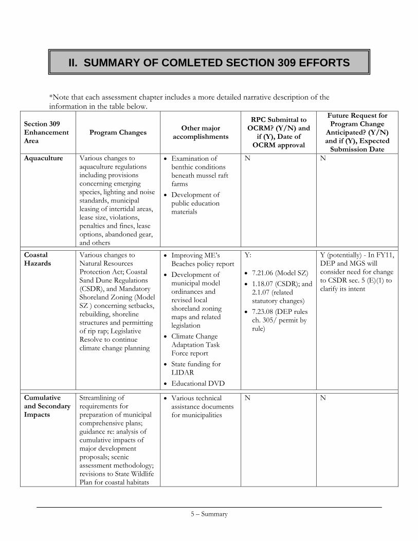
*Note that each assessment chapter includes a more detailed narrative description of the information in the table below.
Program Changes Other major accomplishments
RPC Submittal to OCRM? (Y/N) and
if (Y), Date of OCRM approval
Future Request for Program Change
Anticipated? (Y/N) and if (Y), Expected
Submission Date
Section 309 Enhancement Area
Various changes to aquaculture regulations including provisions concerning emerging species, lighting and noise standards, municipal leasing of intertidal areas, lease size, violations, penalties and fines, lease options, abandoned gear, and others
Examination of benthic conditions beneath mussel raft farms
Development of public education materials
N N Aquaculture
Various changes to Natural Resources Protection Act; Coastal Sand Dune Regulations (CSDR), and Mandatory Shoreland Zoning (Model SZ ) concerning setbacks, rebuilding, shoreline structures and permitting of rip rap; Legislative Resolve to continue climate change planning
Improving ME’s Beaches policy report
Development of municipal model ordinances and revised local shoreland zoning maps and related legislation
Climate Change Adaptation Task Force report
State funding for LIDAR
Educational DVD
Y: 7.21.06 (Model SZ) 1.18.07 (CSDR); and
2.1.07 (related statutory changes)
7.23.08 (DEP rules ch. 305/ permit by rule)
Y (potentially) - In FY11, DEP and MGS will consider need for change to CSDR sec. 5 (E)(1) to clarify its intent
Coastal Hazards
Streamlining of requirements for preparation of municipal comprehensive plans; guidance re: analysis of cumulative impacts of major development proposals; scenic assessment methodology; revisions to State Wildlife Plan for coastal habitats
Various technical assistance documents for municipalities
N N Cumulative and Secondary Impacts
II. SUMMARY OF COMLETED SECTION 309 EFFORTS
5 – Summary
6 – Summary
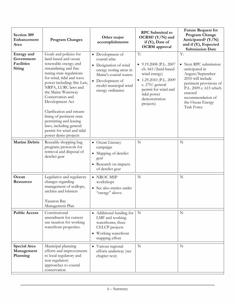
Section 309 Enhancement Area
Program Changes Other major accomplishments
RPC Submittal to OCRM? (Y/N) and
if (Y), Date of OCRM approval
Future Request for Program Change
Anticipated? (Y/N) and if (Y), Expected
Submission Date Energy and Government Facilities Siting
Goals and policies for land-based and ocean renewable energy; and streamlining and fine tuning state regulations for wind, tidal and wave power including: Site Law, NRPA, LURC laws and the Maine Waterway Conservation and Development Act Clarification and stream-lining of pertinent state permitting and leasing laws, including general permit for wind and tidal power demo projects
Development of coastal atlas
Designation of wind energy testing areas in Maine's coastal waters
Development of model municipal wind energy ordinance
Y: 9.19.2008 (P.L. 2007
ch. 661/(land-based wind energy)
1.29.2010 (P.L. 2009 c. 270/ general permit for wind and tidal power demonstration projects)
Y: Next RPC submission
anticipated in August/September 2010 will include pertinent provisions of P.L. 2009 c. 615 which enacted recommendation of the Ocean Energy Task Force
Marine Debris Reusable shopping bag program; protocols for retrieval and disposal of derelict gear
Ocean Literacy campaign
Mapping of derelict gear
Research on impacts of derelict gear
N N
Ocean Resources
Legislative and regulatory changes regarding management of scallops, urchins and lobsters Taunton Bay Management Plan
NROC MSP workshops
See also entries under “energy” above
N N
Public Access Constitutional amendment for current use taxation for working waterfront properties.
Additional funding for LMF and working waterfronts; three CELCP projects
Working waterfront mapping effort
N N
Special Area Management Planning
Municipal planning efforts and improvements to local regulatory and non regulatory approaches to coastal conservation
Various regional efforts underway (see chapter text)
N N
7 – Summary
Section 309 Enhancement Area
Program Changes Other major accomplishments
RPC Submittal to OCRM? (Y/N) and
if (Y), Date of OCRM approval
Future Request for Program Change
Anticipated? (Y/N) and if (Y), Expected
Submission Date Wetlands Changes to NRPA and
implementing regulations re: shorebirds, wading and waterfowl species and vernal pools; wetland monitoring program; creation of in-lieu fee program
Y: 7.21.06 (DEP rules
chs. 335 and 375; DIFW rules ch. 10)
2.7.07 (NRPA) 2.7.08 (NRPA) 7.23.08 (related
changes/DEP rules chs. 305 and 310)
9.19.08 (NRPA) 6.30.09 (DEP rules
chs. 310 and 335)
N

8 – Summary
AQUACULTURE
Section 309 Enhancement Objective
Adoption of procedures and polic ies to evaluate and faci l i tate the si t ing of public and private aquaculture faci l i t ies in the coastal zone, which wil l enable States to formulate, administer , and implement strategic plans for marine aquaculture.
Resource Characterization
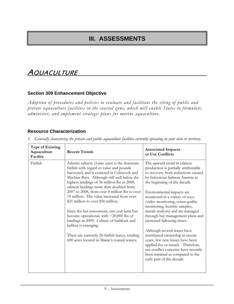
1. Generally characterize the private and public aquaculture facilities currently operating in your state or territory.
Type of Existing Aquaculture Facility
Recent Trends Associated Impacts or Use Conflicts
Finfish Atlantic salmon (Salmo salar) is the dominate finfish with regard to value and pounds harvested, and is centered in Cobscook and Machias Bays. Although still well below the highest landings of 36 million lbs in 2000, salmon landings more than doubled from 2007 to 2008, from over 8 million lbs to over 19 million. The value increased from over $21 million to over $56 million. Since the last assessment, one cod farm has become operational, with ~20,000 lbs of landings in 2009. Culture of haddock and halibut is emerging. There are currently 26 finfish leases, totaling 600 acres located in Maine’s coastal waters.
The upward trend in salmon production is partially attributable to recovery from reductions caused by Infectious Salmon Anemia at the beginning of the decade. Environmental impacts are monitored in a variety of ways (video monitoring, water quality monitoring, benthic samples, metals analysis) and are managed through bay management plans and increased fallowing times. Although several leases have transferred ownership in recent years, few new leases have been applied for or issued. Therefore, use conflict concerns have recently been minimal as compared to the early part of the decade.
III. ASSESSMENTS
9 – Assessments
Shellfish The shellfish sector (primarily American oysters and blue mussels) is centered in the Damariscotta River estuary, where much of the oyster production takes place. Shellfish aquaculture, particularly the oyster industry, continues to develop on a small-scale owner-operator basis. Shellfish growers see enough growth in demand to support their small-scale operations for the next 10-20 yrs., with many planning expansion of production. Production of farm-raised oysters has increased since the last assessment, from 1.94 million pieces in 2005 to over 2.6 million pieces in 2007 and 3.6 million pieces in 2008. Pounds harvested of cultured mussels (bottom and rope) increased from 1.4 million lbs in 2005 to 1.9 million lbs in 2007. There were 13 lease sites producing mussels in 2007. There are currently 77 shellfish leases (including experimental leases), totaling 642 acres
With this expanding industry DMR is aware of increasing interest in the benefits of upper estuary oyster culture. Aquaculturists seek to take advantage of warmer, nutrient rich waters while reducing conflicts with other fisheries (i.e. lobsters, existing lease sites) and navigation. However, expansion within shallow bays and upper estuaries has the potential to encroach upon sea grass beds. One such species, Zostera marina or eelgrass, is an important nursery habitat for many species of fish and invertebrates; it also plays a role in sediment stabilization. Potential impacts on eelgrass are little understood. The lease process is designed to minimize use conflicts to the degree possible. Now, scoping sessions are held prior to the submission of the lease application so that there is an opportunity for the public to provide advice with regard to lease location and configuration, to minimize impacts on other uses.
Management Characterization
1. For each of the management categories below, indicate if the approach is employed by the state or territory and if significant changes have occurred since the last assessment:
Management categories Employed by State Significant change Aquaculture regulations Y Y Aquaculture policies Y N Aquaculture program guidance Y N Research, assessment, monitoring Y Y Mapping Y N Aquaculture education & outreach Y Y
Aquaculture Regulations
In 2009, The Department of Marine Resources revised its Chapter 24 Regulations: Importation of Live Marine Organisms to address pathogen concerns related to the emerging culture of cod (Gadus morhua), haddock (Melanogrammus aeglefinus) and halibut (Hippoglossus hippoglossus). The revised
10 – Assessments
regulations specify disease testing and movement requirements for cultured species of Gadids and Pleuronectids. Summaries of laws enacted since 2006.
Public Law 2005, chapter 92 allowed an aquaculture lease to continue beyond its expiration date until the commissioner makes a decision regarding lease renewal if a renewal application has been submitted. It provided the same restitution provisions for intentionally damaging approved aquaculture gear on standard leases and limited-purpose leases as currently exist for limited-purpose licenses, and it eliminated the $500 upper limit of a fine on the civil violation for intentionally damaging approved aquaculture gear on a limited-purpose license. It exempted an individual who holds a limited-purpose aquaculture license from any requirements regarding time of taking or possessing and minimum or maximum size for organisms cultivated on the individual’s lease areas. The law eliminated the authority of the Commissioner of Marine Resources to establish by rule a fee schedule for the production of shellfish on a lease site. It amended the purpose of the Aquaculture Advisory Council to make recommendations on expenditures from the Aquaculture Management Fund, as well as other matters of interest to the aquaculture industry.
Resolve 2005, chapter 58 approved Chapter 2: Aquaculture Lease Regulations - Lighting Standards and Noise Standards, a major substantive rule of the Department of Marine Resources.
Public Law 2005, chapter 535 increased the number of acres that can be actively used for aquaculture from an aggregate of 300 acres to an aggregate of 500 acres, and authorized the Commissioner of Marine Resources to extend the 500-acre limit by rule but limited the total acreage to 1,500 acres per person. It deleted the 12-month minimum fallowing time so that fallows may be of any duration and gave the Commissioner of Marine Resources the discretion to require a person in aquaculture to submit a fallowing plan and reassessment schedule. Prior to Public Law 2005, chapter 535, a person could be authorized to have up to 500 acres in aquaculture as long as at least 200 acres were fallowed and that person submitted a fallowing plan to the Commissioner of Marine Resources. Finally, it redefined “fallow” to allow gear at the lease site.
Public Law 2007, chapter 212 provided a more specific definition for “intertidal zone” for the Maine Revised Statutes, Title 12, chapter 605, subchapter 2. It also allowed a limited-purpose aquaculture license to be issued to a municipal shellfish committee. It prohibited a person from marking or designating an area as a sea farm or aquaculture lease unless the area is currently leased for aquaculture or is under consideration for leasing through the aquaculture lease process. It also provided that information obtained from other state, federal or foreign government agencies about aquaculture operations in their jurisdictions that is designated as confidential must be kept confidential by the Department of Marine Resources.
Public Law 2009, chapter 229 made the following changes to Maine’s aquaculture laws.
1) Currently, aquaculture leases that are terminated or revoked are permanently lost and there is no option for a new lessee to continue under the same terms and conditions. This law created a mechanism for the Commissioner of Marine Resources to solicit proposals for continued operations at the site for the remainder of the original lease term and under the same terms and conditions and to choose the most suitable proposal. A 2-week public comment period is provided, and fees, not to exceed $5,000, are set in rule.
11 – Assessments
2) It shortened the public comment period for transfer applications and removed the option of a hearing. The application fee was eliminated and a fee for transferring the lease was created in the case of a successful application
3) It increased the limit on the size of an experimental lease from 2 acres to 4 acres.
4) It eliminated the prohibition on limited-purpose aquaculture licenses in intertidal waters as long as permission of the landowner is obtained and creates a nonresident limited-purpose aquaculture license. It established a $300 annual fee for nonresident limited-purpose aquaculture license.
5) It allowed a person to possess cultured marine organisms that do not meet the size or season requirements that wild product must meet. Appropriate documentation must be maintained and made available upon request of the Department of Marine Resources.
6) It eliminated a duplicative notice requirement regarding an aquaculture facility’s use of antibiotics.
7) It created a mechanism to assign lease options, which allow the holder to have first priority in applying for a lease in a particular location. Some other coastal users such as local fishermen or adjacent landowners are still be able to claim preference under the law and nullify the option, but the option prevents other potential applicants that are not specifically given priority in law from moving forward with a lease application in the area until the option has expired. The department must assess whether the application for the option is in good faith and whether it will likely result in an aquaculture application in the area. Fees are charged per acre and are capped at $500 for the first acre and $50 for each additional acre.
8) It authorized the commissioner to refuse to issue or renew a marine resources license, such as a fishing or wholesale license, to the holder of an aquaculture lease or license who has not paid legally required fees.
9) It authorizes the commissioner to require a license for the land-based culture of marine organisms and allows the commissioner to set the fee at not more than $1,000.
10) It authorized the department to remove and sell abandoned aquaculture gear or stock after the lease or license holder and anyone who has previously claimed ownership of the gear or stock has been notified and has failed to remove the gear or stock.
11) It authorized marine patrol officers to inspect aquaculture leases and associated vehicles, watercraft and buildings, except for residences.
12) It allowed municipalities that choose to issue aquaculture permits to charge an application fee that reflects their costs. Public Law 2009, chapter 229 clarified the total acreage allowed under all permits in a municipality, required municipalities to adopt ordinances to prevent speculative holding of permits, updated the maximum rental fee to match the department’s lease fee and clarified that it is an annual rental fee and requires municipalities to submit an annual report to the department.
13) It added aquaculture lease and license holders to the group of persons that the department may authorize to take green crabs without a commercial license.
12 – Assessments
Research, assessment, monitoring
Investigation of benthic conditions under mussel‐raft farms.
After examining the sea floor under several operating mussel-raft farms, Maine Department of Marine Resource Staff questioned the potential nature and extent of environmental degradation caused by organic loading. This project was completed in 2008 to evaluate the extent of organic loading under mussel raft farms and the resulting response of the benthic infaunal community. Funding for this project was provided by the CZM program.
Aquaculture education & outreach
In 2006 the Maine Department of Marine Resources and Maine Sea Grant produced a color brochure outlining the opportunities for public participation during the aquaculture leasing process, Marine Aquaculture in Maine: How the public can participate in the leasing process. The brochure was created to help alleviate misconceptions that the public has no input with regard to the issuance of aquaculture leases in Maine. Since its creation this brochure has served as an excellent resource for members of the public wishing to understand the progression from application to lease issuance or denial and the opportunities along the way for input. Funding for this project was provided by CZM program.
Priority Needs and Information Gaps
Using the table below, identify major gaps or needs (regulatory, policy, data, training, capacity, communication and outreach) in addressing each of the enhancement area objectives that could be addressed through the CMP and partners (not limited to those items to be addressed through the Section 309 Strategy). If necessary, additional narrative can be provided below to describe major gaps or needs.
Type of Gap or Need Level of Priority (H,M,L)
Gap or Need Description
Baseline shellfish pathogen occurrence in wild and farmed populations: initial baseline study and long-term monitoring of sentinel populations
Data High
Updated Chapter 24 Regulations to address shellfish health concerns Regulatory High
Pathologist (staff or consultant) to address current and future fish/shellfish health issues Capacity High
Shellfish Aquaculture Regulatory Handbook/Guide to consolidate the many rules and laws relating to shellfish aquaculture and public health
Communication & Outreach Medium
Effects of suspended oyster aquaculture on eelgrass Data Medium
13 – Assessments
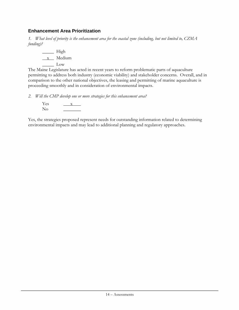
Enhancement Area Prioritization
1. What level of priority is the enhancement area for the coastal zone (including, but not limited to, CZMA funding)?
High x Medium Low
The Maine Legislature has acted in recent years to reform problematic parts of aquaculture permitting to address both industry (economic viability) and stakeholder concerns. Overall, and in comparison to the other national objectives, the leasing and permitting of marine aquaculture is proceeding smoothly and in consideration of environmental impacts. 2. Will the CMP develop one or more strategies for this enhancement area?
Yes x No
Yes, the strategies proposed represent needs for outstanding information related to determining environmental impacts and may lead to additional planning and regulatory approaches.
14 – Assessments
COASTAL HAZARDS
Section 309 Enhancement Objectives
Prevent or signi f icantly reduce threats to li fe and property by eliminating development and redevelopment in high-hazard areas, managing development in other hazard areas, and anticipating and managing the e f fects of potential sea level r ise and Great Lakes level change
Resource Characterization
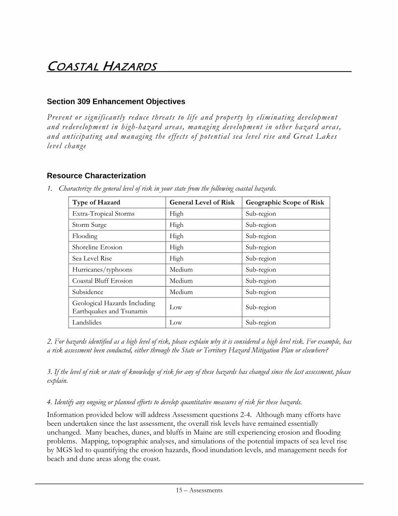
1. Characterize the general level of risk in your state from the following coastal hazards.
Type of Hazard General Level of Risk Geographic Scope of Risk
Extra-Tropical Storms High Sub-region
Storm Surge High Sub-region
Flooding High Sub-region
Shoreline Erosion High Sub-region
Sea Level Rise High Sub-region
Hurricanes/typhoons Medium Sub-region
Coastal Bluff Erosion Medium Sub-region
Subsidence Medium Sub-region
Geological Hazards Including Earthquakes and Tsunamis Low Sub-region
Landslides Low Sub-region 2. For hazards identified as a high level of risk, please explain why it is considered a high level risk. For example, has a risk assessment been conducted, either through the State or Territory Hazard Mitigation Plan or elsewhere?
3. If the level of risk or state of knowledge of risk for any of these hazards has changed since the last assessment, please explain.
4. Identify any ongoing or planned efforts to develop quantitative measures of risk for these hazards.
Information provided below will address Assessment questions 2-4. Although many efforts have been undertaken since the last assessment, the overall risk levels have remained essentially unchanged. Many beaches, dunes, and bluffs in Maine are still experiencing erosion and flooding problems. Mapping, topographic analyses, and simulations of the potential impacts of sea level rise by MGS led to quantifying the erosion hazards, flood inundation levels, and management needs for beach and dune areas along the coast.
15 – Assessments
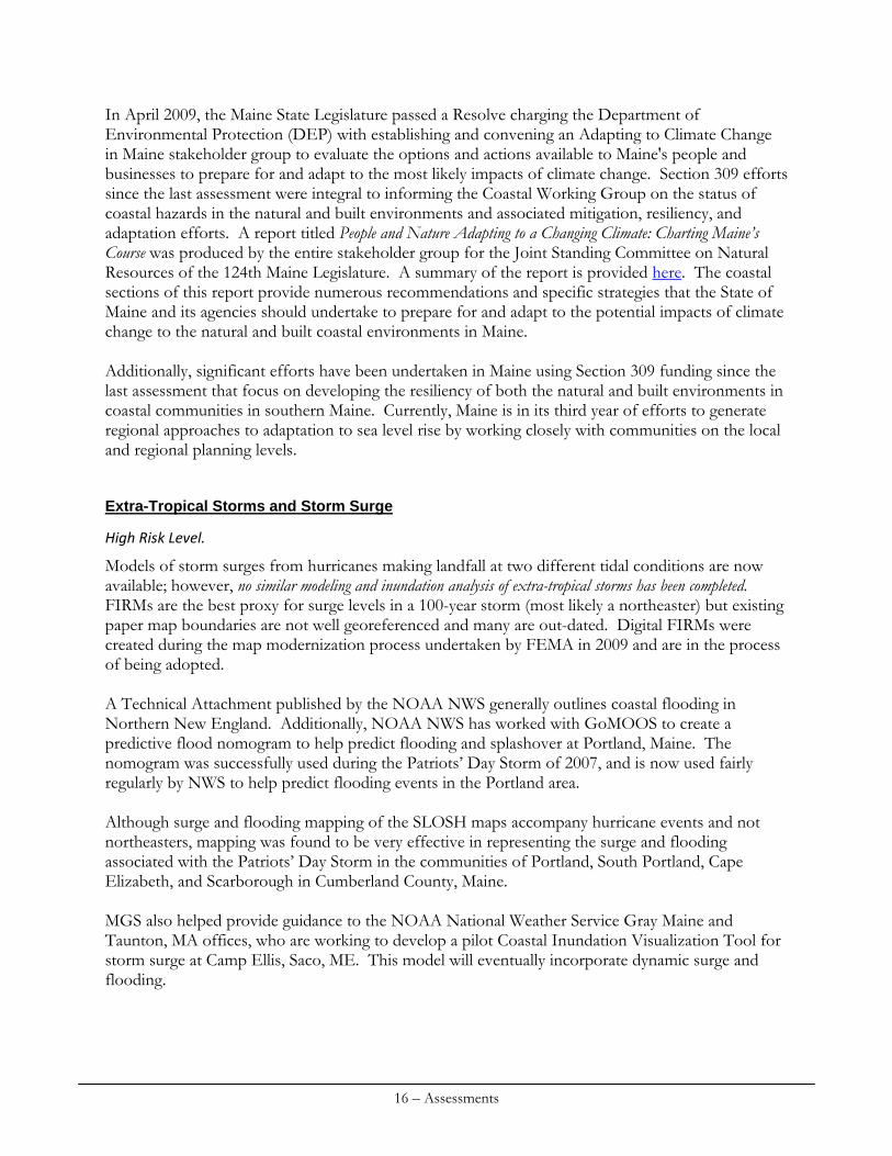
In April 2009, the Maine State Legislature passed a Resolve charging the Department of Environmental Protection (DEP) with establishing and convening an Adapting to Climate Change in Maine stakeholder group to evaluate the options and actions available to Maine's people and businesses to prepare for and adapt to the most likely impacts of climate change. Section 309 efforts since the last assessment were integral to informing the Coastal Working Group on the status of coastal hazards in the natural and built environments and associated mitigation, resiliency, and adaptation efforts. A report titled People and Nature Adapting to a Changing Climate: Charting Maine’s Course was produced by the entire stakeholder group for the Joint Standing Committee on Natural Resources of the 124th Maine Legislature. A summary of the report is provided here. The coastal sections of this report provide numerous recommendations and specific strategies that the State of Maine and its agencies should undertake to prepare for and adapt to the potential impacts of climate change to the natural and built coastal environments in Maine. Additionally, significant efforts have been undertaken in Maine using Section 309 funding since the last assessment that focus on developing the resiliency of both the natural and built environments in coastal communities in southern Maine. Currently, Maine is in its third year of efforts to generate regional approaches to adaptation to sea level rise by working closely with communities on the local and regional planning levels.
Extra-Tropical Storms and Storm Surge
High Risk Level.
Models of storm surges from hurricanes making landfall at two different tidal conditions are now available; however, no similar modeling and inundation analysis of extra-tropical storms has been completed. FIRMs are the best proxy for surge levels in a 100-year storm (most likely a northeaster) but existing paper map boundaries are not well georeferenced and many are out-dated. Digital FIRMs were created during the map modernization process undertaken by FEMA in 2009 and are in the process of being adopted. A Technical Attachment published by the NOAA NWS generally outlines coastal flooding in Northern New England. Additionally, NOAA NWS has worked with GoMOOS to create a predictive flood nomogram to help predict flooding and splashover at Portland, Maine. The nomogram was successfully used during the Patriots’ Day Storm of 2007, and is now used fairly regularly by NWS to help predict flooding events in the Portland area. Although surge and flooding mapping of the SLOSH maps accompany hurricane events and not northeasters, mapping was found to be very effective in representing the surge and flooding associated with the Patriots’ Day Storm in the communities of Portland, South Portland, Cape Elizabeth, and Scarborough in Cumberland County, Maine. MGS also helped provide guidance to the NOAA National Weather Service Gray Maine and Taunton, MA offices, who are working to develop a pilot Coastal Inundation Visualization Tool for storm surge at Camp Ellis, Saco, ME. This model will eventually incorporate dynamic surge and flooding.
16 – Assessments
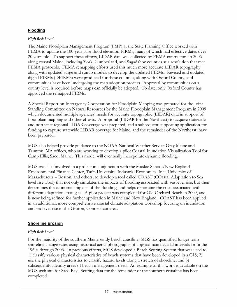
Flooding
High Risk Level.
The Maine Floodplain Management Program (FMP) at the State Planning Office worked with FEMA to update the 100-year base flood elevation FIRMs, many of which had effective dates over 20 years old. To support these efforts, LIDAR data was collected by FEMA contractors in 2006 along coastal Maine, including York, Cumberland, and Sagadahoc counties at a resolution that met FEMA protocols. FEMA remapping efforts used this much more accurate LIDAR topography along with updated surge and runup models to develop the updated FIRMs. Revised and updated digital FIRMs (DFIRMs) were produced for these counties, along with Oxford County, and communities have been undergoing the map adoption process. Approval by communities on a county level is required before maps can officially be adopted. To date, only Oxford County has approved the remapped FIRMs. A Special Report on Interagency Cooperation for Floodplain Mapping was prepared for the Joint Standing Committee on Natural Resources by the Maine Floodplain Management Program in 2009 which documented multiple agencies’ needs for accurate topographic (LIDAR) data in support of floodplain mapping and other efforts. A proposal (LIDAR for the Northeast) to acquire statewide and northeast regional LIDAR coverage was prepared, and a subsequent supporting application for funding to capture statewide LIDAR coverage for Maine, and the remainder of the Northeast, have been prepared. MGS also helped provide guidance to the NOAA National Weather Service Gray Maine and Taunton, MA offices, who are working to develop a pilot Coastal Inundation Visualization Tool for Camp Ellis, Saco, Maine. This model will eventually incorporate dynamic flooding. MGS was also involved in a project in conjunction with the Muskie School/New England Environmental Finance Center, Tufts University, Industrial Economics, Inc., University of Massachusetts – Boston, and others, to develop a tool called COAST (COastal Adaptation to Sea level rise Tool) that not only simulates the impacts of flooding associated with sea level rise, but then determines the economic impacts of the flooding, and helps determine the costs associated with different adaptation strategies. A pilot project was completed for Old Orchard Beach in 2009, and is now being refined for further application in Maine and New England. COAST has been applied in an additional, more comprehensive coastal climate adaptation workshop focusing on inundation and sea level rise in the Groton, Connecticut area.
Shoreline Erosion
High Risk Level.
For the majority of the southern Maine sandy beach coastline, MGS has quantified longer term shoreline change rates using historical aerial photographs of approximate decadal intervals from the 1960s through 2003. In previous efforts, MGS developed a Beach Scoring System that was used to: 1) classify various physical characteristics of beach systems that have been developed in a GIS; 2) use the physical characteristics to classify hazard levels along a stretch of shoreline; and 3) subsequently identify areas of beach management need. An example of this work is available on the MGS web site for Saco Bay. Scoring data for the remainder of the southern coastline has been completed.
17 – Assessments
The Maine Beach Profile Monitoring Program (MBPMP), a volunteer-based Sea-Grant funded initiative involving Sea Grant, the University of Maine, and the MGS, continues to collect monthly beach profile data at 15 southern Maine beaches. Conferences dedicated to reviewing the results of the collected SMBPP data with the general public and interested parties were organized and held in 2007 and 2009. The 2007 Conference focused on the impacts of the Patriots’ Day Storm event on southern Maine beaches. The 2009 Conference focused on the economics of beaches. Detailed reports summarizing beach changes prepared by MGS titled the State of Maine’s Beaches, were also released in 2007 and 2009 in support of the conferences. MGS continues to implement the Maine Beach Monitoring Program (MBMaP). The Program uses high precision RTK-GPS to monitor longshore shoreline characteristics such as the visible high water mark and seaward edge of dune vegetation of Maine’s larger sandy beach systems. Shoreline data has been collected as part of MBMaP on, at a minimum, an annual basis, and in many locations, several times a year, since 2005. Due to the fact that the MGS Marine Geology Division has only two individuals on staff to support these monitoring efforts, for the past 4 years, MGS has been employing a summer intern to aid in data collection supporting MBMaP. MBMaP has been used to monitor shoreline changes at erosional hot spots and dune restoration projects at Ferry Beach, Saco, and also to monitor the success of beach nourishment projects such as Western Beach, Scarborough. As part of these efforts, MGS has also used LIDAR data from different years to determine shoreline changes and beach elevation changes along several different beaches in southern Maine. An assessment was completed for Crescent Beach State Park, Cape Elizabeth and Goochs Beach, Kennebunk.
Sea Level Rise
High Risk Level.
In 2005, MGS completed a pilot study (with NOAA 309 funds) on a small area within the Wells National Estuarine Research Reserve that investigated the impacts of sea level rise on floodplains and coastal wetlands. Subsequently, MGS completed similar simulations for areas of coastal southern Maine that had appropriate 2004 NOAA LIDAR. These studies examined the potential impacts of 2 feet of sea level rise on not only built infrastructure, but also on existing coastal wetland habitats. MGS also completed an analysis of 2006 FEMA LIDAR data in the Casco Bay area to determine whether or not newer FEMA LIDAR was accurate enough for representing existing both low and high marshes. MGS then conducted inundation simulations for 2 feet of sea level rise on several selected marsh areas. Studies found that Maine’s marsh systems and built coastal environment will likely be significantly impacted by sea level rise. MGS, in conjunction with the Southern Maine Regional Planning Commission (SMRPC) is currently in the 3rd year of an overall effort to develop regional approaches to coastal resiliency of select partner communities. These communities include:
Scarborough, Old Orchard Beach, Saco, and Biddeford (in Saco Bay) Kennebunk and York
18 – Assessments
A large focus of this effort includes informing communities on coastal hazards – specifically investigating potential impacts of sea level rise – and developing subsequent planning, mitigation, and adaptation techniques for implementation on a regional basis. The project has consisted of education, outreach, and partnership of working closely with communities to identify existing and potential future problems, and develop appropriate adaptation techniques (e.g., ordinances, capital planning efforts, etc.) that can be implemented on a community-by-community and regional basis. In the Saco Bay area, a steering committee for a Sea Level Adaptation Working Group (SLAWG) has been formed to work on coastal hazards, management, and adaptation on a bay-wide, regional basis. Efforts include working to develop a regional floodplain ordinance and potential future coastal wetland ordinance (or similar) that takes into account future sea level rise. To support SLAWG and resiliency efforts, MGS has developed GIS data showing the impacts of 2 feet of sea level rise in low lying coastal areas of these communities, and SMRPC is working to develop model, transferable ordinances dealing with sea level rise impacts on the coastal floodplain and coastal wetlands under Maine’s Shoreland Zoning Act. MGS also is currently working with the Maine Natural Areas Program (MNAP) to analyze existing LIDAR data for additional sea level rise simulation work. The goal of this project is to identify low-lying uplands and freshwater marsh habitats that are contiguous to large Additional simulations of the effects of a static sea-level rise on different areas of the Maine coastline are currently being undertaken in conjunction with and the Nature Conservancy to identify potential areas of wetland transgression, future flood-prone areas and to adjust emergency routes. This project builds on a previous effort by MGS, funded through the USEPA and the Casco Bay Estuary Partnership, which analyzed LIDAR data in areas of Casco Bay for additional sea level rise simulations. The final report was titled Assessment of LIDAR for Simulating Existing and Potential Future Marsh Conditions in Casco Bay.
Hurricanes/Typhoons
Medium Risk Level.
Just prior to the previous assessment in 2005, the US Army Corps of Engineers (USACE) and National Hurricane Center released Hurricane Storm Surge Inundation Maps for mean tide and high-tide hurricane landfalls based on SLOSH modeling. These maps and subsequent supporting GIS data allowed Maine to refine its state and county emergency management plans in terms of evacuation routes and hurricane response planning. The Maine State Hazard Mitigation Plan was last revised in 2007 and includes the risk of flooding in hurricanes based on mean-tide landfalls from available SLOSH maps. These maps have been used by the Maine Emergency Management Agency (MEMA) and by County Emergency Management Agencies as a disaster response-planning tool. SLOSH maps have been used by the Cumberland County Emergency Management Agency, in conjunction with MEMA and the Greater Portland Council of Governments (GPCOG), to develop hurricane evacuation plans for Portland, Maine
19 – Assessments
Coastal Bluff Erosion and Landslide Hazards
Medium and Low Risk Levels.
The MGS continued to map coastal bluffs and landslide hazards along the Maine coast since the last assessment with support from the MEMA and MCP. At least 1,400 miles (40%) of Maine’s 3,478 miles of tidally influenced shoreline between Kittery and Machias have bluffs and are thus prone to erosion under accelerated rates of sea level rise. Two companion maps, Coastal Bluffs and Coastal Landslide Hazards, have been distributed to municipalities and DEP. Revised in 2005, the MGS web site now includes bluff information, guidance for development and remediation and allows access to view or download the bluff or landslide maps.
Geologic Hazards
Low Risk Level.
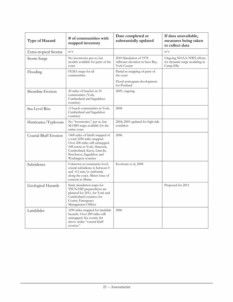
After the December 2004 tsunami struck Indonesia, MGS conducted some research on past and possible future tsunami activity within the Atlantic Ocean and the Gulf of Maine. MGS completed an informational “web site of the month” for January 2005 which discussed past (and future) tsunami activity. This information was used in 2005 for the State Hazard Mitigation Plan. Previous work completed by NOAA animated the resulting tsunami from an earthquake event in the Puerto Rico trench, one of the most likely sources for tsunamis along the east coast of the United States. This simulation resulted in potential offshore stillwater tsunami wave elevations at the -10 m contour elevation; the effort was limited to assumptions of a “cliffed coast” shoreline at the -10 m contour by coarse bathymetric DEM data. Subsequently, in 2008, NOAA has developed a more accurate, 1/3 arc-second DEM for southern Maine for tsunami modeling efforts. MGS is currently working with the Maine Emergency Management Agency and NOAA to develop a much more accurate model that would simulate the potential inundation and runup impacts of a large event triggered by an earthquake in the Puerto Rico Trench using this improved coastal bathymetric dataset. 5. Use the table below to identify the number of communities in the coastal zone that have a mapped inventory of areas affected by the following coastal hazards. If data is not available to report for this contextual measure, please describe below actions the CMP is taking to develop a mechanism to collect the requested data.
20 – Assessments
# of communities with mapped inventory
Date completed or substantially updated
If data unavailable, measures being taken to collect data
Type of Hazard
Extra-tropical Storms n/a n/a
Storm Surge No inventories per se, but models available for parts of the coast
2010 Simulation of 1978 stillwater elevation in Saco Bay, York County
Ongoing NOAA/NWS efforts for dynamic surge modeling in Camp Ellis
Flooding FEMA maps for all communities
Partial re-mapping of parts of the coast
Flood nomogram development for Portland
Shoreline Erosion 20 miles of beaches in 10 communities (York, Cumberland and Sagadahoc counties)
2009, ongoing
Sea Level Rise 13 beach communities in York, Cumberland and Sagadahoc counties)
2008
Hurricanes/Typhoons No “inventories,” per se, but SLOSH maps available for the entire coast
2004; 2005 updated for high-tide condition
Coastal Bluff Erosion 1408 miles of bluffs mapped of a total 3290 miles mapped. Over 200 miles still unmapped. 108 towns in York, Hancock, Cumberland, Knox, Lincoln, Penobscot, Sagadahoc and Washington counties
2006
Subsidence Unknown at community level; crustal subsidence is between 0 and -0.5 mm/yr uniformly along the coast. Minor issue of concern in Maine.
Koohzare et al, 2008
Geological Hazards Static inundation maps for TSUNAMI preparedness are planned for 2011, for York and Cumberland counties; for County Emergency Management Offices
Proposed for 2011
Landslides 3290 miles mapped for landslide hazards. Over 200 miles still unmapped. See county list above under “coastal bluff erosion.”
2006
21 – Assessments
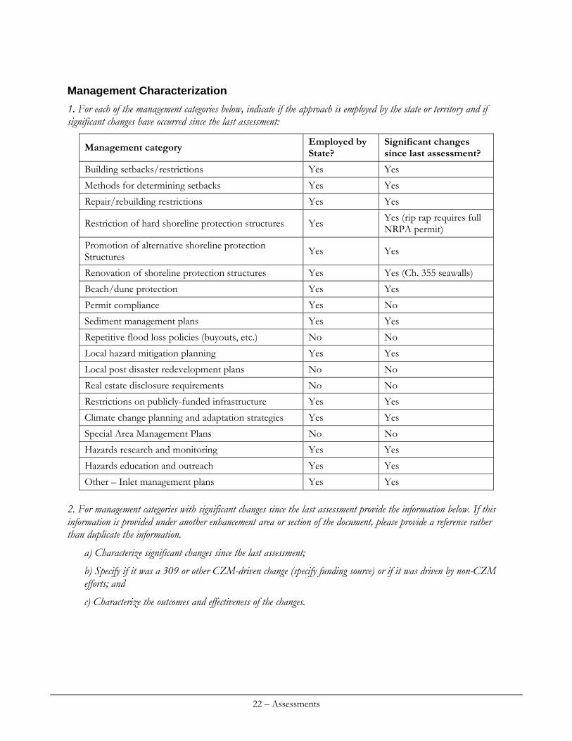
Management Characterization
1. For each of the management categories below, indicate if the approach is employed by the state or territory and if significant changes have occurred since the last assessment:
Employed by State?
Significant changes since last assessment? Management category
Building setbacks/restrictions Yes Yes
Methods for determining setbacks Yes Yes
Repair/rebuilding restrictions Yes Yes
Yes Yes (rip rap requires full NRPA permit) Restriction of hard shoreline protection structures
Promotion of alternative shoreline protection Structures Yes Yes
Renovation of shoreline protection structures Yes Yes (Ch. 355 seawalls)
Beach/dune protection Yes Yes
Permit compliance Yes No
Sediment management plans Yes Yes
Repetitive flood loss policies (buyouts, etc.) No No
Local hazard mitigation planning Yes Yes
Local post disaster redevelopment plans No No
Real estate disclosure requirements No No
Restrictions on publicly-funded infrastructure Yes Yes
Climate change planning and adaptation strategies Yes Yes
Special Area Management Plans No No
Hazards research and monitoring Yes Yes
Hazards education and outreach Yes Yes
Other – Inlet management plans Yes Yes 2. For management categories with significant changes since the last assessment provide the information below. If this information is provided under another enhancement area or section of the document, please provide a reference rather than duplicate the information.
a) Characterize significant changes since the last assessment;
b) Specify if it was a 309 or other CZM-driven change (specify funding source) or if it was driven by non-CZM efforts; and
c) Characterize the outcomes and effectiveness of the changes.
22 – Assessments
Building setbacks/restrictions
Previously, a Section 309 supported study by J.M. Knisel (2003, Hazardous Beach-System Development in Maine and Some Outcomes of the Sand Dune Rules, M.S. Thesis in Marine Policy, University of Maine, Orono, 71 p.) determined that repetitive losses from flooding in Maine’s coastal sand dunes were avoided by the 1988 Coastal Sand Dune Rules (CSDR, Chapter 355 of the Maine Natural Resources Protection Act) and that hazard avoidance was accomplished by the regulations. The study also indicated that non-conforming development was subject to repetitive losses in high hazard locations of the frontal dune that was also either in the V-zone or AO-zone flood hazard areas. The CSDR went through a substantive revision process which was underway during the last assessment. A Beach Stakeholder Group, comprised of state agencies, met over a 2 year period (2004-2006) to revise the previous CSDR at the request of the Maine Legislature. As a result, the Group worked to revise the previous rules. The State officially adopted the revised Coastal Sand Dune Rules (CSDR; Chapter 355 of the Natural Resources Protection Act) in 2006. Revisions to the CSDR were developed by a legislatively approved Coastal Sand Dunes Stakeholder Group comprised of State agencies, NGOs, and local community stakeholder organizations. Changes included: a new definition of future Erosion Hazard Areas, within which all development must be adequately elevated (i.e., on posts) to account for future flooding and erosion; shoreline changes within 100-years; reconstruction standards for buildings damaged (and not damaged) by wave action from an ocean storm, which require moving structures as far landward as practicable; and requirements of increasing sand and water movement. The CSDR also regulate development densities and provides specific requirements for frontal dune vs. back dune projects. These changes were driven by 309-led efforts to codify an Erosion Hazard Area and by pre-existing CSDR restrictions on rebuilding storm-damaged structures. Grant awards from 309 were NA04NOS4190041 (FY05), NA05NOS4191071 (FY06), NA06NOS4190188 (FY07). Additional matching state General Funds were expended simultaneously by DEP and MGS for the stakeholder process facilitated by DEP. In addition to the CSDR changes, the effort led to stronger trust and improved communication among stakeholders, and the creation of a joint report, titled Protecting Maine’s Beaches for the Future. New setbacks from coastal bluffs were established in a 2005 revision to the Mandatory Shoreland Zoning Act (Ch. 1000) administered by DEP. Based on map units in MGS Coastal Bluffs maps, the setback for new development is now determined by the position of the top of an Unstable or Highly Unstable bluff rather than from the shoreline which usually coincides with the base of a bluff. Updated shoreland zoning regulations and maps were adopted by communities in 2009 as part of the Comprehensive Plan update process. Grant award NA04NOS4190041 (FY05) along with financial assistance from MEMA helped release maps and provide Code Enforcement Officer Training through DEP. Old Orchard Beach (as part of the Coastal Resiliency Project with SMRPC and MGS) examined using LIDAR to accurately define the upper limits of the coastal wetland, from which all Shoreland Zoning setbacks are referenced. Previous maps used shorelines from 1:24,000 scale 7.5’ USGS topographic quadrangles as the reference point for the upper limit of the coastal wetland. The use of LIDAR was significantly more accurate and led to substantial horizontal changes in the Shoreland
23 – Assessments
Zone boundaries in Old Orchard Beach. Revised Shoreland Zoning boundaries are currently being reviewed by the Town for potential adoption. Resiliency efforts were initially driven by 309 project funds from grants NA07NOS4190082 (FY08), NA08NOS4190424 (FY09) and NA09NOS4190081 (FY10). Beginning in FY10 some municipalities began to provide supplemental funding to SMRPC.
Methodologies for determining setbacks
The revised CSDR do not permit new construction within the frontal dune aside from certain minor exceptions and “infill” development at a limited number of lots along the coast. The newly defined EHA is used as a setback by locating areas of the back dune system that may become a coastal wetland after a combination of short- and long-term erosion, and sea-level rise. The EHA helps define areas where construction/reconstruction must be elevated to allow for natural movement of sediment and flooding. However, the legal interpretation of the EHA definition, as worded does not meet its original regulatory intent. The EHA is defined as: Any portion of the coastal sand dune system that can reasonably be expected to become part of a coastal wetland in the next 100 years due to cumulative and collective changes in the shoreline from:
Historical long-term erosion; Short-term erosion resulting from a 100-year storm; or Flooding in a 100-year storm after a two-foot rise in sea level, or any portion of the coastal sand dune system that is mapped as an AO flood zone by the effective FEMA
Flood Insurance Rate Map, which is presumed to be located in an Erosion Hazard Area unless the applicant demonstrates based upon site-specific information, as determined by the department, that a coastal wetland will not result from either (1), (2), or (3) occurring on an applicant's lot given the expectation that an AO-Zone, particularly if located immediately behind a frontal dune, is likely to become a V-Zone after 2 feet of sea level rise in 100 years.
By its regulatory definition, coastal wetland includes areas subject to tidal action during the maximum spring tide level as identified in tide tables published by the National Ocean Service (38 M.R.S.A. Sec. 480-B). Thus, based on the current EHA definition, all areas which may become a coastal wetland after 2 feet of sea level rise would be part of an EHA. The original intent of the definition was to pinpoint and place stricter regulations on areas of the back dune considered to be at risk due to coastal flooding or dynamic erosion from the ocean, not to include static flooding from the back marsh, which it currently does. As it is currently worded, the EHA definition is too restrictive and does not meet its original regulatory intent. Thus, MGS and DEP are working to rewrite the definition of an EHA. Mapping of the EHA was funded jointly by DEP in FY07 and with 309 grants in FY04-06. The revised CSDR requires movement of structures landward, as far as practicable, or at a minimum, reconstruction within the same footprint. To facilitate permitting and disclosure of the setback, in October 2005 MGS released on-line versions of the Beach and Dune Geology air photos. MGS used LIDAR and newer aerial photographs (2003) to update the boundaries of the Coastal Sand Dunes. This data has been supplied to partner Resiliency communities, and was also made available in GIS format to the Maine DEP to facilitate permit reviews. Regulatory boundaries of the dune system were remapped with a 309 grant in FY07 with additional MGS match with state General Funds.
24 – Assessments
Areas mapped as Unstable or Highly Unstable Bluffs now have a new setback measured from the top of the bluff (rather than a more seaward tidal shoreline) under the state Mandatory Shoreland Zoning Ordinance (Ch. 1000) adopted in 2006 and administered locally with oversight by DEP. Funding in FY05 with a 309 grant and the state General Fund helped MGS assist DEP with implementing the new ordinance. The outcome has been the widespread use of increased setbacks where there are coastal bluff hazards.
Repair/rebuilding restrictions
The CSDR incorporate a revised definition of the V-zone (which now uses the effective FIRM or LOMA from FEMA) and provides revised guidelines for construction and reconstruction after storm damage within the V-zone. The CSDR have been revised in order to accommodate safer development practices along the shoreline, while at the same time limiting some previously allowed rebuilding activities within the coastal sand dune system. The new CSDR do provide several provisions that allow an applicant to apply for a variance from certain standards. Rebuilding on unstable dunes (non V-zone) in Saco, Maine was tested after the April 2007 Patriots’ Day Storm. Owners of two residential beach homes, destroyed by more than half their appraised value, sought to rebuild with stronger foundations and elevated above the dune. Permits were obtained that included pile-driven foundations to a depth of at least 20 feet and clearance over the dune of 3 feet or more above base flood elevation. In February 2010 a major storm tested the foundation designs which held and prevented additional building damage – thus meeting the 2006 CSDR standard for rebuilding on unstable dunes in the short term. MGS reviews of this precedent-setting activity were supported by the General Fund and 309 FY08 funding. The rule prohibiting rebuilding on such a site after more than 50% damage (i.e. “two strikes”) has not yet been tested in Maine.
Restriction of hard shoreline protection structures
The CSDR were revised by the stakeholder group to clarify which temporary and permanent emergency actions are allowed without a permit under a proposed revision to 38 M.R.S.A. § 480-W. Changes to both the CSDR and to the text of the Natural Resources Protection Act (38 M.R.S.A. Sec. 480-W) were implemented. MGS inventoried shoreline engineering structures with 309 funds in FY08. These data in GIS have the potential to be used for permit compliance cases and in the Beach Scoring System used for resiliency-building efforts at the municipal level.
Promotion of alternative shoreline stabilization methodologies
The revised CSDR includes a new section providing regulatory guidance on the use of beach nourishment and dune restoration. New text in the CSDR also allows a homeowner to move a seawall landward to minimize impacts on the coastal sand dune system. Beach nourishment policies were developed with 309 funding in FY05 and MGS General Funds. The policies were reviewed by the Beach Stakeholder group and adopted in the 2006 Coastal Sand Dune Rules. Beach nourishment and scraping projects have been implemented successfully under these rules in Scarborough, Saco, and Wells. In 2008, a seawall at Higgins Beach, Scarborough, ME was
25 – Assessments
reconstructed in a position and using different materials that were determined to be less damaging to the coastal sand dune system under the revised CSDR.
Renovation of shoreline protection structures
See the preceding two sections above with reference to new text in CSDR and proposed 480-W. Existing shoreline protection structures can be repaired/replaced in their existing position and in their existing dimensions through a DEP Permit-by-Rule. With a permit from the DEP, structures can be changed in their overall shape (but not higher or more seaward than the pre-existing structure) if they are shown to be less damaging to the coastal sand dune system ((5.E. (1)). This new clause in the CSDR was recently challenged when a permit for replacement of a vertical wooden bulkhead with a much larger fitted rip-rap structure was denied based on the increased size of the footprint of the structure; the denial went to the Board of Environmental Protection where it was upheld. The original intent of 5.E.(1) was to allow for vertical structures with existing engineering footprints or existing development directly landward of the wall to be replaced with a sloped-back revetment or similar structure, using the existing development or engineering footprint landward of the wall. It was not the intent of the original clause to allow sloped walls to be built in existing, undeveloped or natural sections of the coastal sand dune system. MGS and DEP will be revisiting this portion of the CSDR in FY11 to see if improvements can be made to the rules. Support for this landmark case was funded at MGS by the General Fund and the 309 FY10 grant. Rulemaking could lead to either (a) continued limits on existing seawalls that allow them to “retreat” in developed areas or (b) modified engineering structures with the ability to withstand larger storms or higher flood levels affording greater property protection at the expense of the beach and dune environment (and contrary to the longstanding prohibition of new seawalls in Maine).
Beach/dune protection
The 2nd Regular Session of the 121st, Maine Legislature passed PL 2003, Resolve 130 directing the formation of a stakeholder group to work together to improve the management and stewardship of Maine’s beaches. The “Framework Agreement on Sand Dunes and Coastal Management in Maine” had eight signatories, including SPO, DEP, DOC and five stakeholder organizations. Protecting Maine’s Beaches for the Future: A Proposal to Create an Integrated Beach Management Program was adopted by the Joint Standing Committee on Natural Resources in February, 2006. Aside from the rule and statute changes discussed in other sections of this management characterization, the Legislature has not funded nor implemented other provisions of the report. No specific implementation plan or funding strategy for state agencies and others has been developed by either the Executive or Legislative branches of Maine government.
Permit compliance
In a 2003 analysis for a University of Maine M.S. Thesis in Marine Policy entitled Hazardous Beach-System Development in Maine and some Outcomes of the Sand Dune Rules, Julia M. Knisel concluded that Ch. 355 was effective in preventing repetitive flood damage claims in coastal flood high hazard areas in Maine’s dunes. This study supported both the rules and mapping of hazardous areas for regulations and concluded that hazards to development in the dunes were being avoided or minimized by the regulations.
26 – Assessments
Sediment management plans
MGS has been involved with planning associated with the regional management of sediment. Beach nourishment was undertaken at Western Beach, Scarborough as the beneficial reuse of dredged material associated with a US Army Corps of Engineers dredging project at the adjacent Scarborough River in the end of 2004. MGS helped the Corps and Scarborough decide on appropriate dredged sediment placement and the resulting beach profile shape. Subsequently, MGS has monitored the fate of the beach nourishment project over the past 5 years. MGS and MCP have also been involved in the Saco Bay Implementation Team (SBIT) which helps oversee the process for involving the US Army Corps in properly mitigating (as part of Section 111 of the Rivers and Harbors Act) for erosion at Camp Ellis, Saco, ME. As part of these efforts, MGS has continually advocated for both the Scarborough and Saco river channels, maintained by the Corps, to be included in the Corps’ Regional Sediment Management (RSM) program. MGS also aided the Department of Conservation in managing inlet migration and sediment response at Popham Beach State Park in Phippsburg, Maine.
Local hazard mitigation planning
MGS has been involved with SMRPC and MCP for three years now on building coastal resiliency within communities in southern Maine. These resiliency efforts tie directly into hazard mitigation planning at the local level. Substantial additions to local ordinances will include those that address future floodplains and coastal wetlands in response to sea level rise, and regional planning efforts for managing local hazards that cross community boundaries, such as installation and management of strategic tide gates or culvert management.
Restrictions on publicly funded infrastructure
The revised CSDR include a clause on the use of publicly funded beach nourishment related to this:
If beach nourishment is funded, in whole or in part with State funds, the portions of the beach nourished with State funds must be placed either into permanent public ownership or under legally binding agreements, such as but not limited to easements that preclude any development and that allow public access for recreational activities.(Chapter 355, 8E).
No significant changes to the last assessment have been undertaken relating to the Coastal Barrier Resources Act.
Climate change planning and adaptation strategies
Significant changes have occurred since the last assessment. First, community-based planning efforts since 2007 with MGS and SMRPC have been underway to develop regional approaches to adaptation to sea level rise as part of a larger coastal resiliency effort. MGS and SMRPC have been working with the communities in Saco Bay (Scarborough, Old Orchard Beach, Saco and Biddeford) in addition to Kennebunk and York to identify the potential impacts of sea level rise on the built
27 – Assessments
and natural environments within the communities, and help the communities adapt to changes using forward-thinking ordinances, capital planning efforts, and regional coordination. Secondly, In April, 2009, the Maine State Legislature passed a Resolve charging the Department of Environmental Protection (DEP) with establishing and convening an Adapting to Climate Change in Maine stakeholder group to evaluate the options and actions available to Maine's people and businesses to prepare for and adapt to the most likely impacts of climate change. Section 309 efforts since the last assessment were integral to informing the Coastal Working Group (of which MCP, MGS, DEP, DMR, and SMRPC were part) on the status of coastal hazards in the natural and built environments and associated mitigation, resiliency, and adaptation efforts. A report titled People and Nature Adapting to a Changing Climate: Charting Maine’s Course was produced by the entire stakeholder group for the Joint Standing Committee on Natural Resources of the 124th Maine Legislature. A summary of the report is provided here. The coastal sections of this report provide numerous recommendations and specific strategies that the State of Maine and its agencies should undertake to prepare for and adapt to the potential impacts of climate change to the natural and built coastal environments in Maine.
Special area management plans
There are currently no SAMPs for coastal hazards in Maine. The Sea Level Adaptation Working Group (SLAWG) formed in 2010 may result in the development of a special area management plan for the four towns bordering Saco Bay.
Hazards research and monitoring
MGS has continued to research and monitor coastal hazards along the Maine coastline since the last assessment, and has made significant strides. These efforts are best summarized under each individual hazard type (see specific sections under the Resource Characterization Section), but research and monitoring has been either continued or undertaken for:
MBMAP (longshore shoreline changes and elevations) MBMP (beach profiles) Sea Level Rise impacts to built and natural environments Coastal Bluff and Landslides Coastal Inundation impacts
Hazards education and outreach
In this assessment period, MGS significantly added to the educational and outreach aspects of its web site containing new content and products on coastal geology and hazards. These changes include the frequently used 309 (FY05) report Impacts of Future Sea Level Rise on the Coastal Floodplain. Reports on The State of Maine’s Beaches in 2007 and 2009 are posted along with content from the Maine Beaches Conference. Frequently asked questions and site-specific reports on coastal areas are plentiful. Information and maps of Coastal Bluffs and Landslide Hazards as well as access to digital GIS data are on the MGS web site.
28 – Assessments
The Maine Coastal Program continues to be a supporter of the Maine Beaches Conference, held biannually in southern Maine. The 2007 and 2009 conferences attracted over 200 homeowners, other interested members of the public, regulators and policy developers. The conference showcased the latest information on coastal hazards data, informs the public about regulatory changes and provides information about what homeowners can do to decrease their risk of property damage from coastal hazards. MGS General Funds provide conference support and MGS provides program planning and content. Maine Sea Grant and other sponsors offer a diverse program for education, outreach, and networking. In 2009, MGS also worked with Maine Sea Grant and the Coastal Program to create a DVD titled Building a Resilient Coast: Maine Confronts Climate Change for the purpose of educating the general public, coastal property owners, managers, and others about coastal resiliency and climate change impacts to the Maine coastline. In 2010, MGS contracted with Maine Sea Grant to develop a Maine Coastal Property Owner Hazard Guide: A Guide to the What, Where, and Why of coastal Maine Hazards, Mitigation, and Adaptation to help educate coastal property owners on identification of coastal hazards, and outline different strategies to address those hazards. MGS and SMRPC continue widespread efforts to further the concept of coastal resiliency within partner communities throughout southern and mid-coast Maine. Multiple meetings have been held with concerned citizens and local managers from the communities of Scarborough, Old Orchard Beach, Saco, Biddeford, Kennebunk, and York. Additional efforts have been made in the Town of Georgetown. Television outreach efforts with local television channels supporting the SLAWG project in Saco Bay have been recorded as well. Additional efforts are needed to release many of the generated GIS layers that MGS has developed over the years to the general public and local managers in an easy to use format. MGS proposes to do this by converting many GIS files depicting different coastal characteristics and hazards into KML format for ease in display in universally available Google Earth application, similar to data for Maine’s mineral resources. Other (Inlet management plans). MGS provides ongoing consultation with the US Army Corps of Engineers (Corps) for the management of federal channels, inlets, and harbors. Evaluation by MGS includes analysis of environmental impacts of dredging on surrounding shorelines and abutting properties in the sand dune system and in the vicinity of coastal bluffs. Shoreline monitoring for MBMAP was extremely valuable in 2009 as the tidal inlet of the Morse River in Phippsburg (mid-coast), Maine threatened to undermine a new $600,000 bath house at Popham Beach State Park. Despite a delineation of the Erosion Hazard Area and over 50 years of shoreline positions, the river migrated unpredictably into the back dunes at the state park and came to within 75 feet of the bath house. MGS devised a temporary “green” use of fallen back dune pitch pine trees from the beach into rope bundles against the dune scarp to slow the river currents and reduce winter storm waves and flooding. In February a channel avulsion (switch) in the Morse River ended the erosion cycle at the state park. Monitoring data gathered with MGS General Funds and 309 funds from FY05-10 were critical in assessing the erosion cycle, where the park would be eroded next, and what type of short-term options could be used. MGS worked with the Department of Conservation, Bureau of Parks and Recreation on a weekly basis through the winter
29 – Assessments
of 2009-2010 to establish a solution. Over the last few years MGS developed four educational web pages on this dynamic inlet system. Lessons learned from extreme and difficult to predict natural cycles can be applied to future management policies for coastal inlets. The Saco River inlet and federal jetty system is the most significant inlet management area in the state. The Saco Bay Implementation Team (SBIT), chaired and led by the MGS, is convened regularly as information and results become available from the Corps on their studies, engineering designs, and alternatives analysis. The SBIT has been very influential with the Corps and City of Saco with analysis and scientific scrutiny of the Corps' work and proposals. In a parallel track, Maine's Congressional Delegation authorized $26 million for a Section 111 project in Saco. The Water Resources Development Act that would appropriate the funds must come through Congress and the Corps must also obtain external technical reviews as well as state permits. MGS has advocated for both the Scarborough and Saco river channels, maintained by the Corps, to be included in the Corps’ Regional Sediment Management program. 3. (CM) Use the appropriate table below to report the number of communities in the coastal zone that use setbacks, buffers, or land use policies to direct development away from areas vulnerable to coastal hazards. If data is not available to report for this contextual measure, please describe below actions the CMP is taking to develop a mechanism to collect the requested data.
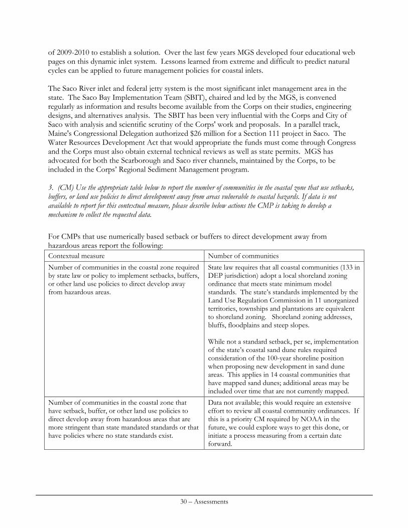
For CMPs that use numerically based setback or buffers to direct development away from hazardous areas report the following: Contextual measure Number of communities
Number of communities in the coastal zone required by state law or policy to implement setbacks, buffers, or other land use policies to direct develop away from hazardous areas.
State law requires that all coastal communities (133 in DEP jurisdiction) adopt a local shoreland zoning ordinance that meets state minimum model standards. The state’s standards implemented by the Land Use Regulation Commission in 11 unorganized territories, townships and plantations are equivalent to shoreland zoning. Shoreland zoning addresses, bluffs, floodplains and steep slopes. While not a standard setback, per se, implementation of the state’s coastal sand dune rules required consideration of the 100-year shoreline position when proposing new development in sand dune areas. This applies in 14 coastal communities that have mapped sand dunes; additional areas may be included over time that are not currently mapped.
Number of communities in the coastal zone that have setback, buffer, or other land use policies to direct develop away from hazardous areas that are more stringent than state mandated standards or that have policies where no state standards exist.
Data not available; this would require an extensive effort to review all coastal community ordinances. If this is a priority CM required by NOAA in the future, we could explore ways to get this done, or initiate a process measuring from a certain date forward.
30 – Assessments
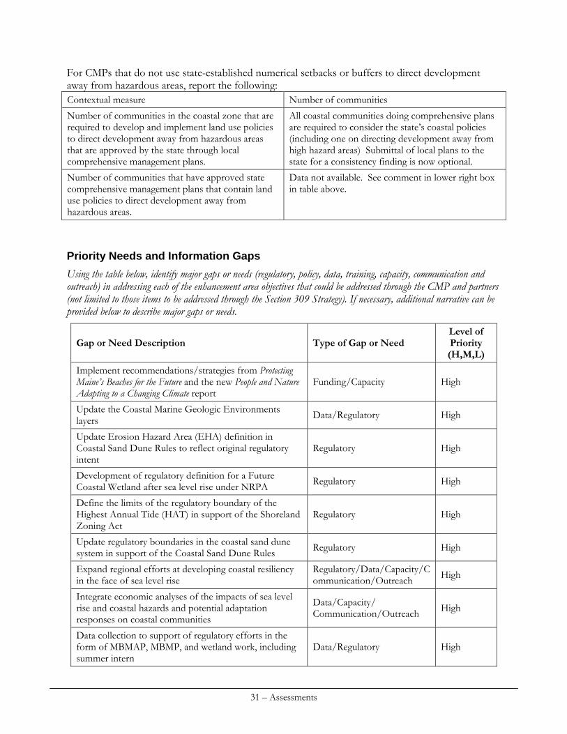
For CMPs that do not use state-established numerical setbacks or buffers to direct development away from hazardous areas, report the following: Contextual measure Number of communities
Number of communities in the coastal zone that are required to develop and implement land use policies to direct development away from hazardous areas that are approved by the state through local comprehensive management plans.
All coastal communities doing comprehensive plans are required to consider the state’s coastal policies (including one on directing development away from high hazard areas) Submittal of local plans to the state for a consistency finding is now optional.
Number of communities that have approved state comprehensive management plans that contain land use policies to direct development away from hazardous areas.
Data not available. See comment in lower right box in table above.
Priority Needs and Information Gaps
Using the table below, identify major gaps or needs (regulatory, policy, data, training, capacity, communication and outreach) in addressing each of the enhancement area objectives that could be addressed through the CMP and partners (not limited to those items to be addressed through the Section 309 Strategy). If necessary, additional narrative can be provided below to describe major gaps or needs.
Type of Gap or Need Level of Priority (H,M,L)
Gap or Need Description
Implement recommendations/strategies from Protecting Maine’s Beaches for the Future and the new People and Nature Adapting to a Changing Climate report
Funding/Capacity High
Update the Coastal Marine Geologic Environments layers Data/Regulatory High
Update Erosion Hazard Area (EHA) definition in Coastal Sand Dune Rules to reflect original regulatory intent
Regulatory High
Development of regulatory definition for a Future Coastal Wetland after sea level rise under NRPA Regulatory High
Define the limits of the regulatory boundary of the Highest Annual Tide (HAT) in support of the Shoreland Zoning Act
Regulatory High
Update regulatory boundaries in the coastal sand dune system in support of the Coastal Sand Dune Rules Regulatory High
Expand regional efforts at developing coastal resiliency in the face of sea level rise
Regulatory/Data/Capacity/Communication/Outreach High
Integrate economic analyses of the impacts of sea level rise and coastal hazards and potential adaptation responses on coastal communities
Data/Capacity/ Communication/Outreach High
Data collection to support of regulatory efforts in the form of MBMAP, MBMP, and wetland work, including summer intern
Data/Regulatory High
31 – Assessments
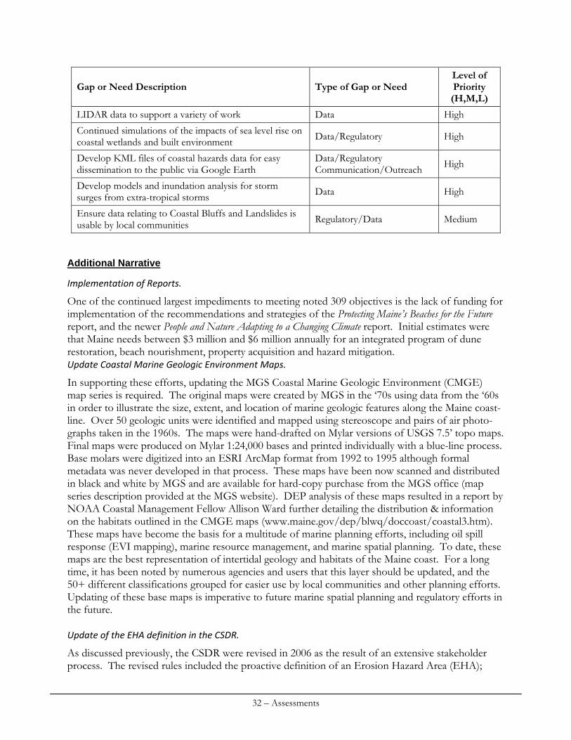
32 – Assessments
Gap or Need Description Type of Gap or Need Level of Priority (H,M,L)
LIDAR data to support a variety of work Data High
Continued simulations of the impacts of sea level rise on coastal wetlands and built environment Data/Regulatory High
Develop KML files of coastal hazards data for easy dissemination to the public via Google Earth
Data/Regulatory Communication/Outreach High
Develop models and inundation analysis for storm surges from extra-tropical storms Data High
Ensure data relating to Coastal Bluffs and Landslides is usable by local communities Regulatory/Data Medium
Additional Narrative
Implementation of Reports.
One of the continued largest impediments to meeting noted 309 objectives is the lack of funding for implementation of the recommendations and strategies of the Protecting Maine’s Beaches for the Future report, and the newer People and Nature Adapting to a Changing Climate report. Initial estimates were that Maine needs between $3 million and $6 million annually for an integrated program of dune restoration, beach nourishment, property acquisition and hazard mitigation. Update Coastal Marine Geologic Environment Maps.
In supporting these efforts, updating the MGS Coastal Marine Geologic Environment (CMGE) map series is required. The original maps were created by MGS in the ‘70s using data from the ‘60s in order to illustrate the size, extent, and location of marine geologic features along the Maine coast-line. Over 50 geologic units were identified and mapped using stereoscope and pairs of air photo-graphs taken in the 1960s. The maps were hand-drafted on Mylar versions of USGS 7.5’ topo maps. Final maps were produced on Mylar 1:24,000 bases and printed individually with a blue-line process. Base molars were digitized into an ESRI ArcMap format from 1992 to 1995 although formal metadata was never developed in that process. These maps have been now scanned and distributed in black and white by MGS and are available for hard-copy purchase from the MGS office (map series description provided at the MGS website). DEP analysis of these maps resulted in a report by NOAA Coastal Management Fellow Allison Ward further detailing the distribution & information on the habitats outlined in the CMGE maps (www.maine.gov/dep/blwq/doccoast/coastal3.htm). These maps have become the basis for a multitude of marine planning efforts, including oil spill response (EVI mapping), marine resource management, and marine spatial planning. To date, these maps are the best representation of intertidal geology and habitats of the Maine coast. For a long time, it has been noted by numerous agencies and users that this layer should be updated, and the 50+ different classifications grouped for easier use by local communities and other planning efforts. Updating of these base maps is imperative to future marine spatial planning and regulatory efforts in the future. Update of the EHA definition in the CSDR.
As discussed previously, the CSDR were revised in 2006 as the result of an extensive stakeholder process. The revised rules included the proactive definition of an Erosion Hazard Area (EHA);
however, implementation of the definition, as written, proved to be difficult due to wording that did not reflect the EHA’s original regulatory intent. Therefore, substantive rulemaking and rewording of the definition is required. Develop a regulatory definition of a Future Coastal Wetland.
Previous 309 efforts by MGS to simulate the impacts of sea level rise on the coastal wetlands show that low-lying uplands will likely become areas of future coastal wetland after 2 feet of sea level rise. Maine recognizes that protection of the natural environment by allowing natural processes to occur through regulatory structure is vital, and thus identifies the need for a new regulatory definition for a future coastal wetland be developed. Define the limits of HAT for the Shoreland Zoning Act.
Maine’s Shoreland Zoning Act focuses on local implementation of specific regulations concerning activities within the shoreland zone. Areas falling within the shoreland zone are defined by a distance from the highest annual tide in coastal communities. However, the limits of highest water are generally defined using outdated sources, such as USGS 7.5’ quadrangles from the 1970s. This boundary can now be accurately delineated using LIDAR data, and will make the boundaries of the shoreland zone in communities much more accurate. Expand regional efforts at developing coastal resiliency in the face of sea level rise.
Ongoing efforts related to developing coastal resiliency at the local and regional level have been undertaken by MGS, MCP, and SMRPC. Expansion of these efforts to other areas of the Maine coast, and involving other regional and state collaborators, is required for continued efficiency of developing appropriate adaptation responses to sea level rise from the regulatory, planning, and capital development standpoints. Integrate economic analyses of the impacts of sea level rise and coastal hazards and potential adaptation responses on coastal communities.
Efforts such as the COAST pilot in Old Orchard Beach and continued integration of science, regulation, and economics in dealing with approaches to sea level rise as demonstrated in the ICLEI pilot project in Groton, CT demonstrate that including economic analyses into local decision-making is vital to understanding hazard impacts and the costs of potential adaptation strategies. Regional efforts that incorporate economic analyses tools, such as COAST, along with collaboration amongst agencies, communities, and regional groups, are needed. Data collection in support of MBMAP, MBMP, and wetland work.
Availability of a uniform and comprehensive data set of geological information for hazard identification and regulatory use is another major impediment. Sound scientific data that meets CSDR standards are essential to support MGS project analyses for DEP, for environmental gain, to avoid siting new development in hazardous locations, and for municipal beach management. Impediments include lack of funding for staff and steady revenue for ongoing data collection and shoreline monitoring. The MBMP provides temporally (monthly) adequate data for determining short-term shoreline change. However this program is experiencing funding shortfalls and perhaps discontinuation at some locations in 2011. Impediments include continued funding for MBMP and MGS data collection for MBMAP. Over time these data are critical to updating the regulatory
33 – Assessments
boundaries of the Erosion Hazard Area and to monitoring the effects of climate variability (storminess, flooding, erosion rates) on the state’s most vulnerable shoreline areas. These data will be necessary to drive policy decisions related to increases in sea level, tides, and coastal floodplains. MGS needs a regular intern to help implement the MBMAP data collection in support of these other efforts.
LIDAR data to support a variety of work efforts.
Although Maine has LIDAR data from 2000, 2004, 2006, and 2007, the geographic scope of the data has been constrained to within a limited distance of the coastline, and only for southern Maine. This topographic data is the basis for much of the simulation and work efforts that have been undertaken for coastal hazard mapping and coastal resiliency development within communities. Additional LIDAR data of sufficient accuracy is required for the remainder of the Maine coastline (and extending inland of adequate distance to simulate impacts of sea level rise to coastal wetland systems) to support expansion of these efforts. Continued simulations of the impacts of sea level rise on coastal wetlands and built environment.
Coastal resiliency project efforts, in addition to other 309 pilot and project efforts, resulted in substantial work simulating the impacts of sea level rise on the coastal wetlands of Maine and the built environment. This data is vital to local decision-making, rule-making, and development of ordinances. This effort includes identifying low-lying uplands that will likely become coastal wetlands after sea level rise, and identifying existing infrastructure (public and private, vital to communities and region) that would be inundated. Additional simulation is needed for areas of the Maine coast that have not been mapped using LIDAR. Develop KML files of coastal hazard data.
With the growth in use of Google Earth and the ease of serving up GIS data into Google Earth for extensive public usage, MGS will continue public outreach and education efforts by converting its coastal hazards GIS files into KML format for use in Google Earth, consistent with what has been developed for Maine’s mineral resources. Develop models and inundation analysis for storm surges from extra‐tropical storms.
There is a documented need for detailed models that simulate dynamic inundation of problematic areas of the Maine coast from storm surge from extra-tropical storms. SLOSH data exists for tropical storms, but no inundation models have been developed for the much more common, and greater impacting, northeast storms that hit the Maine coast. Initial efforts with the NOAA NWS in Saco, ME for developing a Coastal Inundation Visualization Tool should be taken to the next level by developing a dynamic model incorporating surge and wave impacts. Ensure data relating to Coastal Bluffs and Landslides is usable by local communities.
Several impediments or developments arose in establishing bluff setbacks. The first is due to the lack of technical mapping (geographic information systems) capacity at the local level. While the GIS data are free to download from the state, some municipalities do not have the in-house ability to generate Shoreland Zoning maps. In addition, some towns have limited budgets to contract out mapping services. Second, citizens in the Town of York voted down the use of the Coastal Bluff
34 – Assessments
Maps because a legal disclaimer on the map legend said the maps should not be used as the “sole source” of information for determining a setback. Third, other towns (led by Belfast) considered whether or not to allow new coastal engineering to “stabilize” an Unstable or Highly Unstable bluff and thus return the setback to the tidal shoreline position. Fourth, the Town of Yarmouth has raised concerns that the field mapping is now a decade old and that some of the bluff shorelines have changes and have sought assistance on remapping sections of the shoreline. Fifth, due to lack of funds from any source, some sections of the coast remain unmapped so there are municipalities (mostly in Washington County such as Lubec and Eastport) that do not have coastal bluff data to implement the Shoreland Zoning standards of Ch. 1000.
Enhancement Area Prioritization
1. What level of priority is the enhancement area for the coastal zone (including, but not limited to, CZMA funding)?
x High Medium Low
Coastal hazards analysis, identification, and avoidance continue to be high management priorities in Maine. The coastal population has continued to grow in southern Maine and the density and value of coastal development has held value in southern Maine despite the deep recession and its national impact on property values. Population and economic trends are expected to continue to require greater technical expertise at the state level and outreach to manage development in high hazard areas, to protect fragile coastal resources, and to adapt to climate change. Continued coastal growth places additional strain on already limited State resources. While Maine government recognizes the importance of its sandy beaches for their numerous environmental and economic benefits, state revenue shortfalls constrain staff and program growth. Continuing to address coastal hazards in a proactive way through 309 funding will enable Maine to support and improve new CSDR, to provide the basis for future wetland conservation, and to advance adaptation measures to preserve vital coastal resources impacted by accelerated sea level rise. 2. Will the CMP develop one or more strategies for this enhancement area?
Yes x No
Significant efforts will be made to develop specific 309 strategies to address the needs and gaps identified as part of this latest assessment. Strategies are outlined in the next section.
35 – Assessments
CUMULATIVE & SECONDARY IMPACTS
Section 309 Enhancement Objective
Development and adoption of procedures to assess, consider, and control cumulative and secondary impacts of coastal growth and development, including the col lective e f fec t on various individual uses or act ivit ies on coastal resources, such as coastal wetlands and f ishery resources.
Resource Characterization
Maine’s coastal towns continue to experience development pressure although the economic downturn of the last several years has temporarily slowed that pressure somewhat. Currently, over 40% of the state’s population lives in coastal towns. From 2000 to 2008 the population of coastal towns grew 2.36% to 574,144. Consequently, there were approximately 5,600 more housing units in coastal Maine in 2008 than in 2000, based on an average of 2.35 people per household as reported by the US Census. The highest rates of growth along the coast are occurring in towns located in southern Maine. Coastal towns in York County grew by 21% between 1990 and 2008 and are expected to grow another 7.5% by 2013. While Maine’s growth Management Act encourages towns to identify targeted growth and rural areas, much of the growth is occurring outside of the designated growth areas. This results in fragmentation of the outlying rural areas and the resulting diminishment of habitat, working rural landscapes, and natural character within the coastal zone. Additional growth also results in increased amounts of impervious surface, increasing amounts of run-off and increasing non-point source pollution, degrading both the physical and biological characteristics of the coastal zone. 1. Identify areas in the coastal zone where rapid growth or changes in land use require improved management of cumulative and secondary impacts (CSI) since the last assessment. Provide the following information for each area:
Type of growth or change in land use
Rate of growth or change in land use (% change, average acres converted, H,M,L)
Types of CSI Geographic area
Residential and commercial
M Increasing levels of development, impervious surface, NPS, habitat fragmentation, loss of rural character
Southern, mid-coast, Downeast
36 – Assessments
2. Identify sensitive resources in the coastal zone (e.g., wetlands, waterbodies, fish and wildlife habitats, critical habitat for threatened and endangered species) that require a greater degree of protection from the cumulative or secondary impacts of growth and development. If necessary, additional narrative can be provided below to describe threats.
Sensitive resources CSI threats description Level of threat (H,M,L)
Coastal wetlands Hardening of the upland edge; sea level rise; invasive species; increased NPS; habitat fragmentation
H
Coastal BwH Focus Areas Habitat fragmentation H/M
Riparian buffers Fragmentation from development M
Coastal Rivers Lack of connectivity H
Impaired coastal waters Marine water quality in Maine continues to be high with 94% of state waters deemed as meeting state water quality standards excepting the advisory on lobster tomalley consumption due to legacy PCB contamination. This percentage of attainment is almost identical to that assessed in 2006. The principal source of impairments in those remaining 6% of state waters is from legacy pollutants such as PAH’s or other toxics and bacterial contamination, either from combined sewer overflows or nonpoint source pollution including septic systems, agricultural operations, or stormwater runoff.
M
Management Characterization
1. For each of the management categories below, indicate if the approach is employed by the state or territory and if significant changes have occurred since the last assessment:
Employed by state/territory (Y or N)
Significant changes since last assessment (Y or N) Management Categories
Y Y comprehensive plan rule Regulations
Policies Y N
Y
Y Natural Resources Protection Act (NRPA) cumulative impact assessment methodology
Guidance
Management Plans N N
37 – Assessments
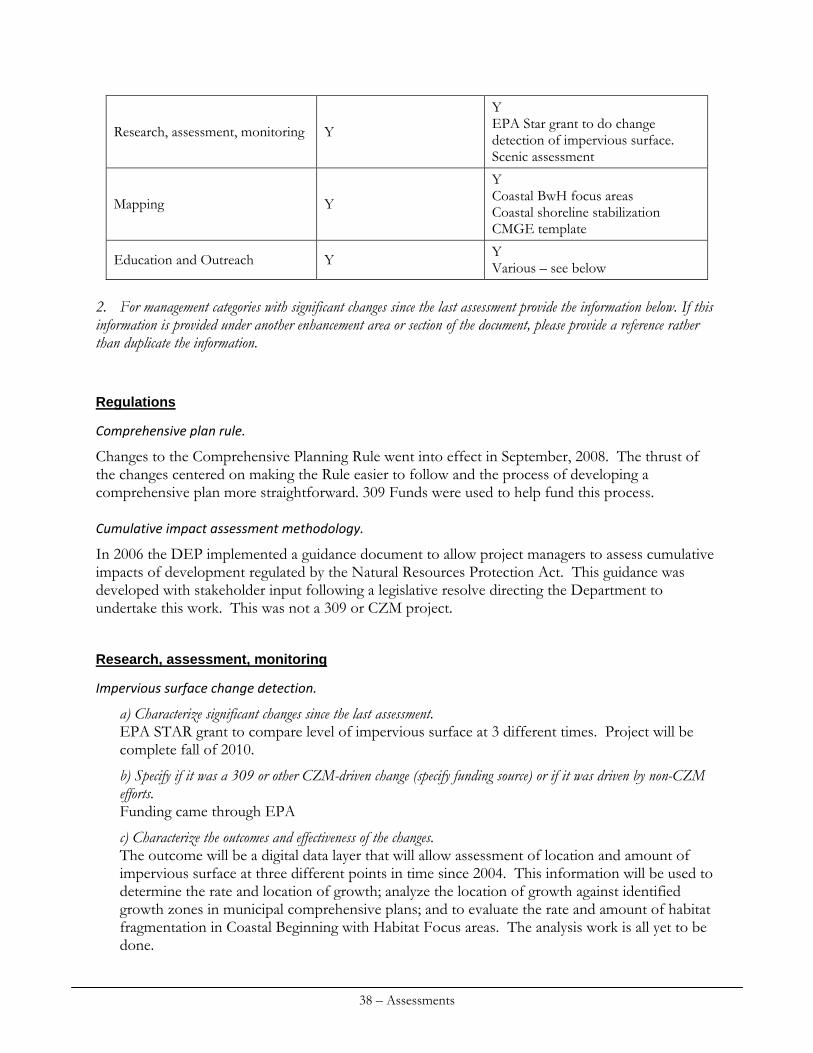
Y
Y EPA Star grant to do change detection of impervious surface. Scenic assessment
Research, assessment, monitoring
Y
Y Coastal BwH focus areas Coastal shoreline stabilization CMGE template
Mapping
Y Y Various – see below Education and Outreach
2. For management categories with significant changes since the last assessment provide the information below. If this information is provided under another enhancement area or section of the document, please provide a reference rather than duplicate the information.
Regulations
Comprehensive plan rule.
Changes to the Comprehensive Planning Rule went into effect in September, 2008. The thrust of the changes centered on making the Rule easier to follow and the process of developing a comprehensive plan more straightforward. 309 Funds were used to help fund this process. Cumulative impact assessment methodology.
In 2006 the DEP implemented a guidance document to allow project managers to assess cumulative impacts of development regulated by the Natural Resources Protection Act. This guidance was developed with stakeholder input following a legislative resolve directing the Department to undertake this work. This was not a 309 or CZM project.
Research, assessment, monitoring
Impervious surface change detection.
a) Characterize significant changes since the last assessment. EPA STAR grant to compare level of impervious surface at 3 different times. Project will be complete fall of 2010.
b) Specify if it was a 309 or other CZM-driven change (specify funding source) or if it was driven by non-CZM efforts. Funding came through EPA
c) Characterize the outcomes and effectiveness of the changes. The outcome will be a digital data layer that will allow assessment of location and amount of impervious surface at three different points in time since 2004. This information will be used to determine the rate and location of growth; analyze the location of growth against identified growth zones in municipal comprehensive plans; and to evaluate the rate and amount of habitat fragmentation in Coastal Beginning with Habitat Focus areas. The analysis work is all yet to be done.
38 – Assessments

Scenic Assessment Methodology & Downeast Inventory.
a) Characterize significant changes since the last assessment. Existing scenic assessment methodology was updated to use GIS to identify scenic views within the coastal zone. The methodology was adapted as a rule by SPO in 2009.
b) Specify if it was a 309 or other CZM-driven change (specify funding source) or if it was driven by non-CZM efforts. This was a CZM Section 309 funded project.
c) Characterize the outcomes and effectiveness of the changes. Scenic inventories were conducted in Hancock and Washington counties filling a gap and completing the inventory series for the entire coast. This recent work is available digitally making it much more accessible and user-friendly. Converting the previous inventories to digitized format will be accomplished with CZM 306 funds.
Mapping
Coastal Beginning with Habitat Focus Areas.
a) Characterize significant changes since the last assessment. Coastal focus areas were adopted into the State Wildlife Action Plan in January 2009.
b) Specify if it was a 309 or other CZM-driven change (specify funding source) or if it was driven by non-CZM efforts. CZM supported this effort through staff time and funding.
c) Characterize the outcomes and effectiveness of the changes. Coastal Focus Areas were delineated (based on coastal and terrestrial resources) for the entire coast.
Coastal Shoreline Stabilization.
a) Characterize significant changes since the last assessment. MGS and MCP worked with a GIS student on an evaluation of coastal shoreline stabilization performed under the Maine DEP permit by rule (PBR) process in a selected number of towns along the Maine coast. This study identifies where and how many stabilization projects were constructed, and what coastal marine habitats were impacted. A GIS model was developed using DEP PBR data for 2000-2009, coastal hazards bluffs armoring data and coastal marine geological environments definitions. The model maps the adjacency of projects to each other and existing armoring and the distance from coastal marine habitats.
b) Specify if it was a 309 or other CZM-driven change (specify funding source) or if it was driven by non-CZM efforts. CZM supported this effort through staff time and funding (Section 306).
c) Characterize the outcomes and effectiveness of the changes. The report identifies several issues that, if changed, would make assessment and analysis of this data richer and more meaningful. The issues identified include changes to the application requiring better information on the location, length and type of shoreline armoring taking place.
39 – Assessments
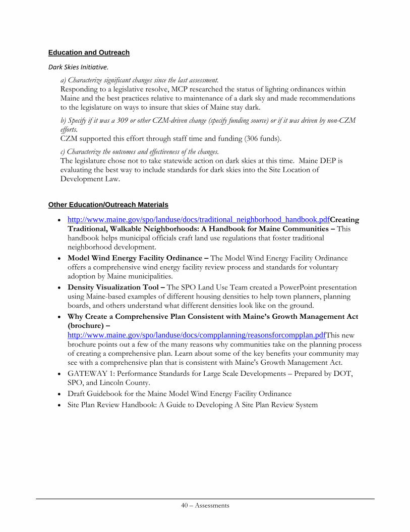
Education and Outreach
Dark Skies Initiative.
a) Characterize significant changes since the last assessment. Responding to a legislative resolve, MCP researched the status of lighting ordinances within Maine and the best practices relative to maintenance of a dark sky and made recommendations to the legislature on ways to insure that skies of Maine stay dark.
b) Specify if it was a 309 or other CZM-driven change (specify funding source) or if it was driven by non-CZM efforts. CZM supported this effort through staff time and funding (306 funds).
c) Characterize the outcomes and effectiveness of the changes. The legislature chose not to take statewide action on dark skies at this time. Maine DEP is evaluating the best way to include standards for dark skies into the Site Location of Development Law.
Other Education/Outreach Materials
http://www.maine.gov/spo/landuse/docs/traditional_neighborhood_handbook.pdfCreating Traditional, Walkable Neighborhoods: A Handbook for Maine Communities – This handbook helps municipal officials craft land use regulations that foster traditional neighborhood development.
Model Wind Energy Facility Ordinance – The Model Wind Energy Facility Ordinance offers a comprehensive wind energy facility review process and standards for voluntary adoption by Maine municipalities.
Density Visualization Tool – The SPO Land Use Team created a PowerPoint presentation using Maine-based examples of different housing densities to help town planners, planning boards, and others understand what different densities look like on the ground.
Why Create a Comprehensive Plan Consistent with Maine’s Growth Management Act (brochure) – http://www.maine.gov/spo/landuse/docs/compplanning/reasonsforcompplan.pdfThis new brochure points out a few of the many reasons why communities take on the planning process of creating a comprehensive plan. Learn about some of the key benefits your community may see with a comprehensive plan that is consistent with Maine's Growth Management Act.
GATEWAY 1: Performance Standards for Large Scale Developments – Prepared by DOT, SPO, and Lincoln County.
Draft Guidebook for the Maine Model Wind Energy Facility Ordinance Site Plan Review Handbook: A Guide to Developing A Site Plan Review System
40 – Assessments
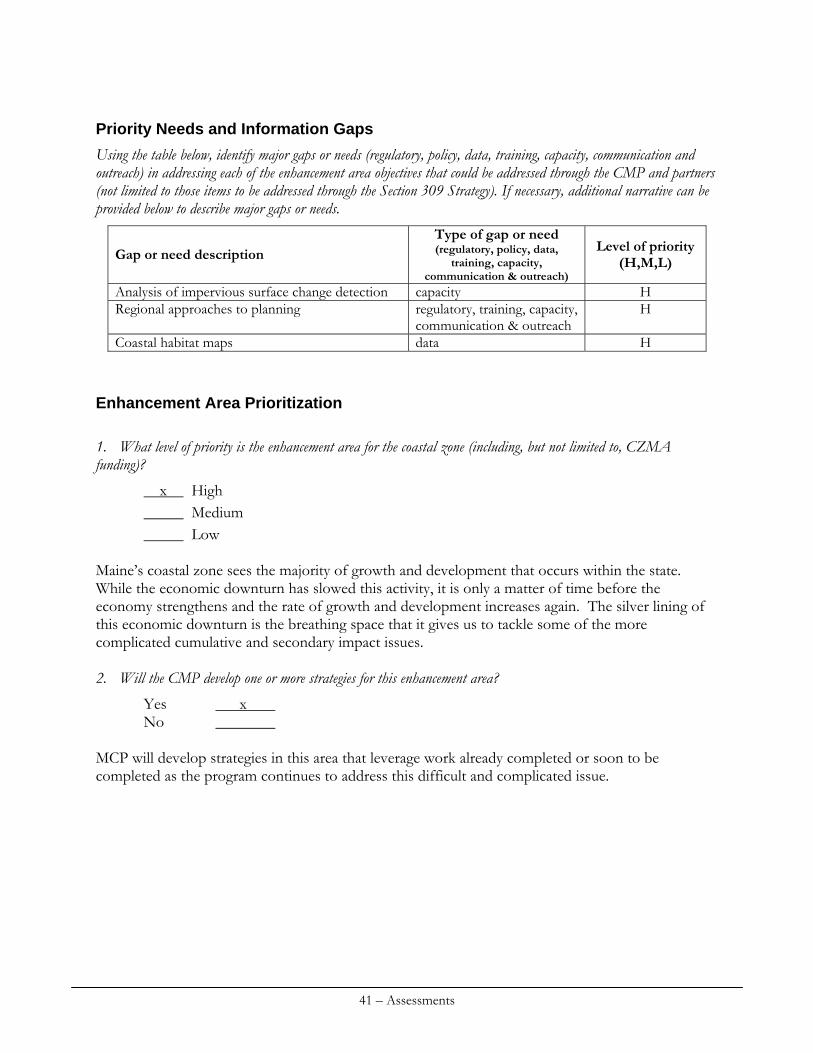
Priority Needs and Information Gaps
Using the table below, identify major gaps or needs (regulatory, policy, data, training, capacity, communication and outreach) in addressing each of the enhancement area objectives that could be addressed through the CMP and partners (not limited to those items to be addressed through the Section 309 Strategy). If necessary, additional narrative can be provided below to describe major gaps or needs.
Type of gap or need (regulatory, policy, data,
training, capacity, communication & outreach)
Level of priority (H,M,L) Gap or need description
Analysis of impervious surface change detection capacity H Regional approaches to planning regulatory, training, capacity,
communication & outreach H
Coastal habitat maps data H
Enhancement Area Prioritization
1. What level of priority is the enhancement area for the coastal zone (including, but not limited to, CZMA funding)?
x High Medium Low
Maine’s coastal zone sees the majority of growth and development that occurs within the state. While the economic downturn has slowed this activity, it is only a matter of time before the economy strengthens and the rate of growth and development increases again. The silver lining of this economic downturn is the breathing space that it gives us to tackle some of the more complicated cumulative and secondary impact issues. 2. Will the CMP develop one or more strategies for this enhancement area?
Yes x No
MCP will develop strategies in this area that leverage work already completed or soon to be completed as the program continues to address this difficult and complicated issue.
41 – Assessments
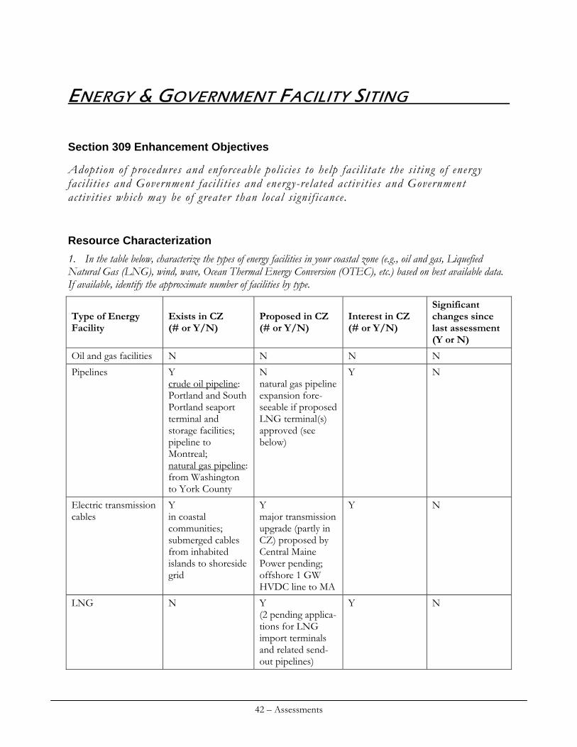
ENERGY & GOVERNMENT FACILITY SITING
Section 309 Enhancement Objectives
Adoption of procedures and enforceable polic ies to help faci l i tate the si t ing of energy faci l i t ies and Government faci l i t ies and energy-related activit ies and Government act ivit ies which may be of greater than local s ignif icance.
Resource Characterization
1. In the table below, characterize the types of energy facilities in your coastal zone (e.g., oil and gas, Liquefied Natural Gas (LNG), wind, wave, Ocean Thermal Energy Conversion (OTEC), etc.) based on best available data. If available, identify the approximate number of facilities by type.
Exists in CZ (# or Y/N)
Proposed in CZ (# or Y/N)
Interest in CZ (# or Y/N)
Significant changes since last assessment (Y or N)
Type of Energy Facility
Oil and gas facilities N N N N
Pipelines Y crude oil pipeline: Portland and South Portland seaport terminal and storage facilities; pipeline to Montreal; natural gas pipeline: from Washington to York County
N natural gas pipeline expansion fore-seeable if proposed LNG terminal(s) approved (see below)
Y N
Y in coastal communities; submerged cables from inhabited islands to shoreside grid
Y major transmission upgrade (partly in CZ) proposed by Central Maine Power pending; offshore 1 GW HVDC line to MA
Y N Electric transmission cables
LNG N Y (2 pending applica-tions for LNG import terminals and related send-out pipelines)
Y N
42 – Assessments
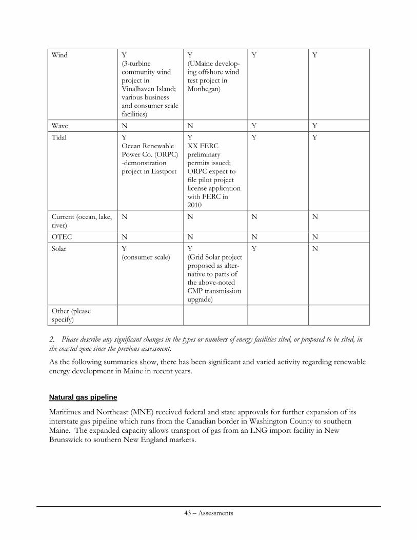
Wind Y (3-turbine community wind project in Vinalhaven Island; various business and consumer scale facilities)
Y (UMaine develop-ing offshore wind test project in Monhegan)
Y Y
Wave N N Y Y
Tidal Y Ocean Renewable Power Co. (ORPC) -demonstration project in Eastport
Y XX FERC preliminary permits issued; ORPC expect to file pilot project license application with FERC in 2010
Y Y
N N N N Current (ocean, lake, river)
OTEC N N N N
Solar Y (consumer scale)
Y (Grid Solar project proposed as alter-native to parts of the above-noted CMP transmission upgrade)
Y N
Other (please specify)
2. Please describe any significant changes in the types or numbers of energy facilities sited, or proposed to be sited, in the coastal zone since the previous assessment.
As the following summaries show, there has been significant and varied activity regarding renewable energy development in Maine in recent years.
Natural gas pipeline
Maritimes and Northeast (MNE) received federal and state approvals for further expansion of its interstate gas pipeline which runs from the Canadian border in Washington County to southern Maine. The expanded capacity allows transport of gas from an LNG import facility in New Brunswick to southern New England markets.
43 – Assessments
LNG
FERC dismissed without prejudice Quoddy Bay LNG’s application to build an LNG terminal and associated natural gas pipeline in Washington County when the company’s efforts to address regulatory process requirements stalled. Downeast LNG withdrew its CZMA certification, water quality certification, and related state license and permit applications for its proposed LNG terminal and pipeline in Washington County, citing needs for redesign of project elements necessitated by its inability to secure rights of way through the Moosehorn National Wildlife Refuge needed for its proposed send out pipeline route. Downeast is expected to reapply for requisite state approvals after, potentially in 2010, FERC issues the FEIS for its proposal. A third developer, Calais LNG, proposed an LNG terminal and send-out pipeline in Washington County. Its proposal is now under active consideration by the State and FERC.
Wind
Commercial facilities.
Fox Island Electrical Cooperative (Co-op), which is a consumer-owned utility that serves Vinalhaven, Maine, has constructed a three-turbine wind power project on the Island. Project-generated power is used to meet on-island customer needs; surplus power is sold to the grid, under Maine’s net-billing law, to help finance the project. The Co-op has initiated a test project to create off-peak demand for project-generated power for home heating and vehicles. Although Maine is by far New England's largest producer of wind energy, with the exception of the Fox Island project, all the wind power generating facilities in the state are located outside the coastal zone in mountainous areas. Test facilities.
Maine is positioned to be the nation's leader in deep-water wind energy technology and development, due in part to pioneering work at the University of Maine (UMaine) in advance composite materials, engineering and design and related development and policy initiatives. UMaine is in the process of developing a deep-water wind technology test proposal for siting off Monhegan Island. This project would be the first permitted under Maine’s innovative and recently adopted (see below) law establishing an adaptive management-oriented general permit for qualified offshore wind energy test projects.
Pumped storage hydro
Riverbank Hydro is proposing to develop a 1 gigawatt pumped storage facility on the Sheepscot River in Wiscasset, Maine. The project calls for excavation of massive storage caverns deep below the earth alongside the river. As it falls from the river into the storage caverns, the water would turn turbines to produce electricity at peak demand times when market prices are high; off-peak, when prices are low, water would be pumped up from the storage caverns and returned to the river. The applicant has cited the project’s potential to serve as a wind power “battery” (providing a market for wind power generated off-peak) as a synergistic benefit supportive of Maine’s offshore wind power goals.
44 – Assessments
Tidal
Following completion and publication of the Electric Power Research Institute’s (EPRI) study assessing the potential of Maine’s wave and tidal power resources noted in Maine prior 309 proposal, FERC has received numerous applications for preliminary permits for tidal power development at sites ranging along the entire length of Maine’s coast. The tidal in-stream energy conversion project proposed by Ocean Renewable Power Corporation (ORPC) in Eastport, Maine, has made the most progress toward commercial development. ORPC has built and operated a small-scale test project. In 2010, ORPC is expected to file for a FERC pilot project license and related Maine general permit (see below) for its 5 MW pilot tidal power project. FERC dismissed the application for the Half-Moon Cove Project in Washington County when the applicant did not provide information the Commission required for regulatory review. The applicant’s proposal involved construction of a tidal barrage.
Transmission infrastructure
The Maine Express project is a proposed build a 1 gigawatt offshore, underwater high-voltage DC (HVDC) power line to transport energy produced in Maine to southern New England markets. This submerged merchant line would connect to the landside grid in Wiscasset, Maine, and, buried in the seafloor, run beneath state and federal waters to land in the Boston area. 3. Does the state have estimates of existing in-state capacity and demand for natural gas and electric generation? Does the state have projections of future capacity? Please discuss.
Information compiled in Maine’s Energy Plan indicates that in 2008 Maine consumed 50,000 million cubic feet of natural gas. Much of this was used for electric power generation. ISO-New England projects increased demand in natural gas use in Maine and elsewhere in the New England region. The price of natural gas effectively sets the price of electricity in Maine and elsewhere in the ISO-NE region. Data from 2006 show that there are 3.456 MW of electric power generating capacity in Maine. Maine is currently a net exporter of electric power. ISO-NE estimates that in 2016 2000 MW of generating capacity will be needed to meet demand in Maine. 4. Does the state have any specific programs for alternative energy development? If yes, please describe including any numerical objectives for the development of alternative energy sources. Please also specify any offshore or coastal components of these programs.
Maine has a renewable portfolio standard (RPS). The following summary prepared by the Union of Concerned Scientists (see http://www.ucsusa.org/assets/documents/clean_energy/maine.pdf) provides a useful summary of Maine’s RPS:
“Originally passed as part of Maine’s restructuring law, the renewable portfolio standard (RPS) requires that 30 percent of the generation sold in the state come from eligible renewable resources by 2000. This is the highest percent requirement of any state standard, but the RPS did not support new renewable energy development as Maine already generated about half of its power from existing biomass and hydroelectric resources. In June 2007, Maine passed legislation (P.L. 2007, ch. 403)
45 – Assessments
that requires the development of new renewable resources, beginning at 1 percent in 2008, and increasing 1 percent annually to 10 percent in 2017, and thereafter. Compliance is achieved through the acquisition of renewable energy certificates that are issued and tracked through the New England Generation Information System (NE-GIS). In addition, P.L. 2007, ch. 403 allows competitive electric providers to fulfill their annual requirements by making alternative compliance payments to a Renewable Resource Fund, which will be used to support new renewable energy development.”
Maine’s Wind Energy Act (MWEA) sets ambitious goals that reflect the State’s national leadership on this issue, particularly as concerns deep-water offshore wind energy. As recently amended, MWEA calls for siting of eight gigawatts of wind energy generation capacity by 2030. P.L. 2009, ch. 615, which stems from recommendations made by Governor Baldacci’s Ocean Energy Task Force, makes it the State’s goal to generate five of the these eight gigawatts from offshore sources. The State has placed particular emphasis on deep-water wind given the world-class wind resource in OCS areas adjoining state waters. These goals are intended to reflect Maine’s ability and commitment as a national leader on deep-water ocean wind development to make a significant contribution to the national wind power goal of producing 20% of the nation’s electricity with wind power by 2030. 5. If there have been any significant changes in the types or number of government facilities sited in the coastal zone since the previous assessment, please describe.
Pursuant to recommendations of the federal Base Closure and Realignment Commission (BRAC), the Brunswick Naval Air Station is in the final stages of base closure. The Navy has consulted with the MCP and otherwise worked closely with the State and local communities in developing and implementing closure plans, which include transfer of base property for redevelopment. With the benefit of federal stimulus funds, the Navy has been making a host of improvements to the Portsmouth Naval Shipyard's facilities. Review of these actions has been a major part of the work of DEP’s southern Maine office's federal consistency-oriented work, particularly over the past year or so.
Management Characterization
1. Does the state have enforceable policies specifically related to energy facilities? If yes, please provide a brief summary, including a summary of any energy policies that are applicable to only a certain type of energy facility.
Select state land use and environmental statutes and their implementing regulations provide the enforceable policies of Maine’s coastal program. With a couple of notable exceptions, Maine does not have enforceable policies specifically related to energy facilities. Those exceptions are the Wind Energy Act, implemented through the Site Location of Development Act (Site Law), Natural Resources Protection Act (NRPA), and land use and zoning laws administered by the Land Use Regulation Commission (LURC) and the Maine Waterway Development and Conservation Act, which governs hydropower development, including tidal and wave power. In recent years, each of the above-noted laws has been amended to streamline and fine tune state regulation of wind, tidal and wave power. The State intends to submit the most recent of these
46 – Assessments
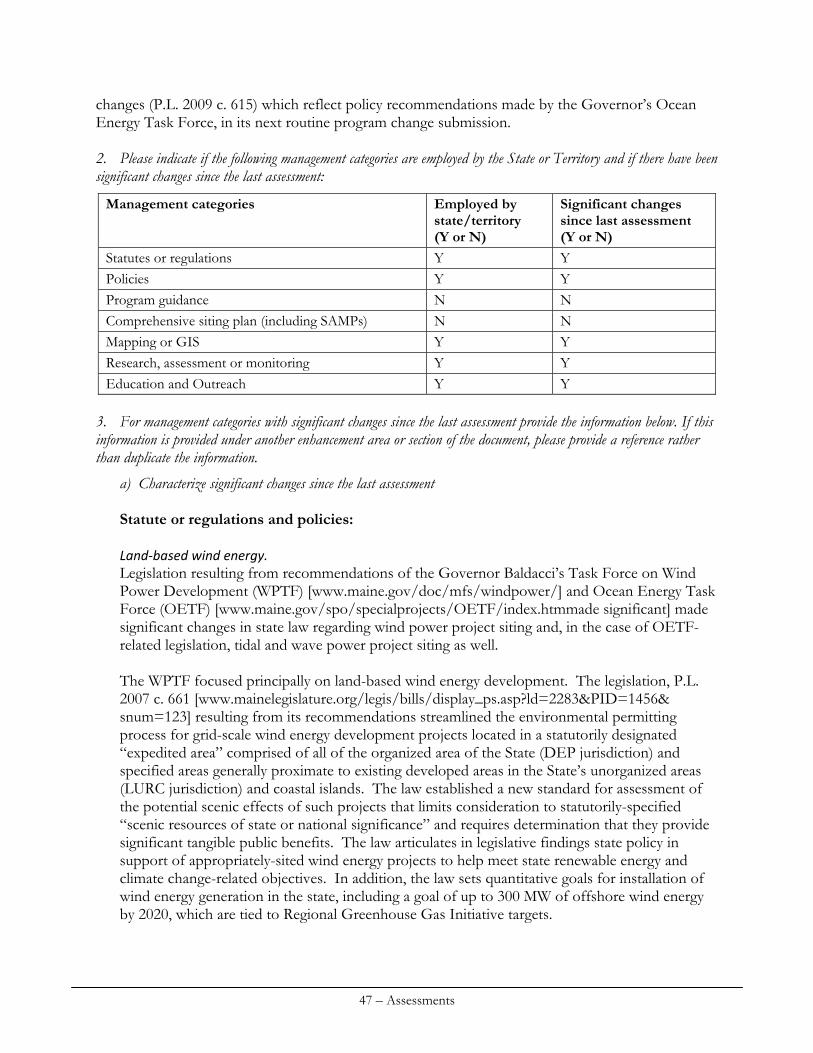
changes (P.L. 2009 c. 615) which reflect policy recommendations made by the Governor’s Ocean Energy Task Force, in its next routine program change submission. 2. Please indicate if the following management categories are employed by the State or Territory and if there have been significant changes since the last assessment:
Management categories Employed by state/territory (Y or N)
Significant changes since last assessment (Y or N)
Statutes or regulations Y Y Policies Y Y Program guidance N N Comprehensive siting plan (including SAMPs) N N Mapping or GIS Y Y Research, assessment or monitoring Y Y Education and Outreach Y Y
3. For management categories with significant changes since the last assessment provide the information below. If this information is provided under another enhancement area or section of the document, please provide a reference rather than duplicate the information.
a) Characterize significant changes since the last assessment Statute or regulations and policies: Land‐based wind energy. Legislation resulting from recommendations of the Governor Baldacci’s Task Force on Wind Power Development (WPTF) [www.maine.gov/doc/mfs/windpower/] and Ocean Energy Task Force (OETF) [www.maine.gov/spo/specialprojects/OETF/index.htmmade significant] made significant changes in state law regarding wind power project siting and, in the case of OETF-related legislation, tidal and wave power project siting as well. The WPTF focused principally on land-based wind energy development. The legislation, P.L. 2007 c. 661 [www.mainelegislature.org/legis/bills/display_ps.asp?ld=2283&PID=1456& snum=123] resulting from its recommendations streamlined the environmental permitting process for grid-scale wind energy development projects located in a statutorily designated “expedited area” comprised of all of the organized area of the State (DEP jurisdiction) and specified areas generally proximate to existing developed areas in the State’s unorganized areas (LURC jurisdiction) and coastal islands. The law established a new standard for assessment of the potential scenic effects of such projects that limits consideration to statutorily-specified “scenic resources of state or national significance” and requires determination that they provide significant tangible public benefits. The law articulates in legislative findings state policy in support of appropriately-sited wind energy projects to help meet state renewable energy and climate change-related objectives. In addition, the law sets quantitative goals for installation of wind energy generation in the state, including a goal of up to 300 MW of offshore wind energy by 2020, which are tied to Regional Greenhouse Gas Initiative targets.
47 – Assessments
P.L. 2009 c. 642 reflects DEP and LURC experience implementing the above-described land-based wind power siting laws. Overall, this law clarifies and further details the requirement that expedited wind energy projects provide significant tangible public benefits; makes DEP and LURC processes more consistent; and clarifies and refines current provisions regarding judicial review of LURC permitting decisions and assessment of fees for permit review. SPO developed a model wind energy ordinance and a companion guide for Maine as technical assistance for municipalities’ use and consideration [www.maine.gov/spo/landuse/index.htm]. Renewable ocean energy. Legislation stemming from recommendations of Governor Baldacci’s Ocean Energy Task Force (OETF) (P.L. 2009, ch. 270 and P.L. 2009, ch. 615) focused on streamlining and facilitating promising renewable ocean energy resources in state and adjoining federal ocean waters. P.L. 2009, ch. 270 [www.mainelegislature.org/ros/LOM/LOM124th/124R1/PUBLIC270.asp] creates state general permits for testing offshore wind energy technologies in designated places in Maine’s coastal waters and for tidal power technologies eligible for approval under FERC’s permit process for hydrokinetic pilot projects. In December 2009, DOC, in consultation with SPO, designated three such ocean test sites in Maine’s coastal waters. The law also gives DEP statewide permitting jurisdiction pursuant to the Maine Waterway Development and Conservation Act (MWDCA) over tidal power projects and harmonizes state permitting and submerged lands leasing requirements regarding qualified wind and tidal power test projects. P.L. 2009, ch. 615 [www.mainelegislature.org/ros/LOM/LOM124th/124R2/PUBLIC615.asp] implements recommendations of the Governor’s Ocean Energy Task Force. In pertinent part, the law amends current Maine Coastal Program core laws and other related state laws to clarify and streamline how ocean energy development activities are regulated. Such are activities were subject to state environmental permitting prior to enactment of these amendments, which reflect on-going program improvement in keeping with state policy to facilitate renewable energy development. Pertinent provisions will be submitted as routine program changes in the State’s next RPC submission. The following summarizes the law’s siting-related highlights: amends MWDCA to articulate state policy in support of both tidal and wave power development at appropriate locations; amends laws administered by LURC to define approval criteria for a “community-based offshore wind energy project,” which the law makes the only type of offshore wind energy development subject LURC review and approval; harmonize LURC permitting and state submerged lands leasing requirements; and make DEP and LURC approval criteria for offshore and land-based wind power projects more consistent; makes changes to offshore wind energy-related laws administered by DEP to further streamline the approval process for wind and tidal power test projects eligible for a general permit under P.L. 2007 c. 270; clarifies applicability of the Site Law to offshore wind power projects; harmonize DEP permitting and state submerged lands leasing requirements; and make DEP and LURC approval criteria for offshore and land-based wind power development proposals more consistent; amends MWDCA to provide that DEP has statewide jurisdiction over wave power projects under that law (as noted above, P.L. 2009 c. 270 gave DEP statewide authority under the MWDCA over tidal power); and clarifies local zoning and permitting authority regarding renewable ocean energy projects.
48 – Assessments
The law includes legislative policy statements that clarify that state public trust submerged lands and waters may be used for renewable ocean energy projects. The law directs the Bureau of Parks and Lands (BPL) to amend its submerged lands leasing rules to establish a fee schedule for leasing submerged lands for renewable ocean energy projects “that balances state goals of assurance of fair compensation for use and mitigation of potential adverse effects on or conflict with existing uses of state-owned submerged lands that are held in trust for the people of the State with state renewable ocean energy-related goals. . . .” The law also amends the Wind Energy Act to set an ambitious goal, noted above, for installed wind energy capacity – a total of 8 GW, including 5 GW of offshore wind energy, which the OETF deemed commensurate with the potential of deep-water wind energy resources in the Gulf of Maine and well-aligned with national wind energy goals. The law directs the Maine Public Utilities Commission to issue a solicitation in the fall of 2009 for a long-term contract for up to 25 MW of deep-water wind energy and 5 MW of tidal power, subject to a statutorily-set price cap. Tidal power MOUs. The State has developed memoranda of understanding with FERC and with the Province of Nova Scotia. These MOUs reflect the administration’s policy support for well-sited tidal power development in Maine’s coastal zone and recognition of the benefits of cooperation with other jurisdictions to facilitate such development. The FERC-State MOU aligns Maine’s above-described general permit for tidal power permitting with FERC’s process for tidal in-stream energy conversion pilot projects. The Nova Scotia-Maine MOU focuses on information sharing and other cooperation on tidal energy-related matters of mutual interest. Federal R&D funding. Maine’s clear articulation of policies supporting renewable ocean energy has also helped researchers secure significant U.S. DOE funding for both tidal and offshore wind research and development initiatives in the state. In addition, EDA has provided about $1.5 million to a partnership that includes Washington County and the City of Eastport to establish a marine energy manufacturing center to help improve the state’s renewable ocean energy manufacturing supply chain. Mapping/GIS: See ocean resources management section of this document re: Coastal Atlas. Research, assessment and monitoring: See ocean resources management section of this document.
b) Specify if it was a 309 or other CZM-driven change (specify funding source) or if it was driven by non-CZM efforts CZMA Section 309 supported MCP SPO staff efforts to support two task forces formed by Governor Baldacci to establish policies, regulatory reform and other methods for advancement of land- based wind and ocean based renewable energy. CZMA Section 309 funds also supported outreach efforts associated with the designation of ocean energy demonstration sites, purchase of fishing data and equipment to assess fishing effort and establishment of the coastal atlas.
49 – Assessments
c) Characterize the outcomes and effectiveness of the changes. DEP and LURC have both approved land-based grid-scale wind energy projects pursuant to the above-described expedited permitting process and related standards. Accordingly, the State is making notable progress toward legislatively-set wind energy and related policy goals. Maine is New England’s leader in terms of installed wind energy capacity. Some members of the public, particularly in communities where grid-scale wind energy projects have been proposed, have expressed concerns about the expedited permitting process. These concerns have focused principally on applicable noise control and scenic review standards, impacts on community character, and the unique and streamlined administrative and judicial review processes that the law established for these projects. To date, courts have upheld appeals of DEP and LURC permitting decisions raising these and related issues. Other appeals are pending. At the direction of the Legislature, the Office of Energy Independence and Security is undertaking a review to inform state policy decisions regarding the efficacy and potential need for revision of pertinent state noise control standards. It is reasonably foreseeable that agency or legislative action stemming from consideration of the results of this review or related information, or possibly from court decisions, may result in further refinement of state law and policy regarding terrestrial wind power development. Overall, it is premature to assess the effectiveness of the renewable ocean energy siting related changes described above. To date, no projects have been proposed and reviewed under the above-described ocean wind energy laws, although the University of Maine is actively engaged in developing a wind energy test demonstration project for consideration under the general permit created by P.L. 2009 c. 270. Ocean Renewable Power Corporation (ORPC) is advancing through the federal and state approval process for its commercial-scale tidal power project in Eastport. ORPC’s project is the project slated for consideration under the above-described MWDCA general permit for tidal power development. The State continues to be actively engaged in renewable ocean energy related policy efforts in furtherance of the OETF’s recommendations. For example, the State is working with BOEMRE to initiate a Maine Task Force to consider deep-water wind energy development opportunities on OCS areas in the Gulf of Maine proximate to Maine and working with NROC to shape and advance regional coastal and marine spatial planning.
50 – Assessments
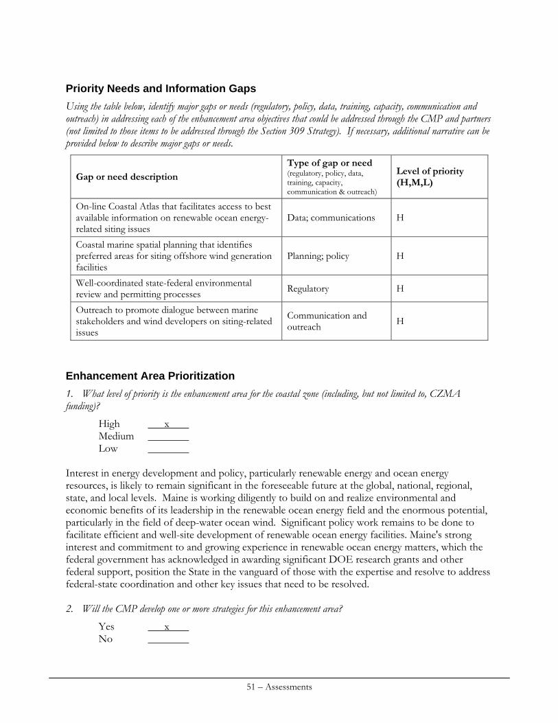
Priority Needs and Information Gaps
Using the table below, identify major gaps or needs (regulatory, policy, data, training, capacity, communication and outreach) in addressing each of the enhancement area objectives that could be addressed through the CMP and partners (not limited to those items to be addressed through the Section 309 Strategy). If necessary, additional narrative can be provided below to describe major gaps or needs.
Type of gap or need (regulatory, policy, data, training, capacity, communication & outreach)
Level of priority (H,M,L) Gap or need description
On-line Coastal Atlas that facilitates access to best available information on renewable ocean energy-related siting issues
Data; communications H
Coastal marine spatial planning that identifies preferred areas for siting offshore wind generation facilities
Planning; policy H
Well-coordinated state-federal environmental review and permitting processes Regulatory H
Outreach to promote dialogue between marine stakeholders and wind developers on siting-related issues
Communication and outreach H
Enhancement Area Prioritization
1. What level of priority is the enhancement area for the coastal zone (including, but not limited to, CZMA funding)?
High x Medium Low
Interest in energy development and policy, particularly renewable energy and ocean energy resources, is likely to remain significant in the foreseeable future at the global, national, regional, state, and local levels. Maine is working diligently to build on and realize environmental and economic benefits of its leadership in the renewable ocean energy field and the enormous potential, particularly in the field of deep-water ocean wind. Significant policy work remains to be done to facilitate efficient and well-site development of renewable ocean energy facilities. Maine's strong interest and commitment to and growing experience in renewable ocean energy matters, which the federal government has acknowledged in awarding significant DOE research grants and other federal support, position the State in the vanguard of those with the expertise and resolve to address federal-state coordination and other key issues that need to be resolved. 2. Will the CMP develop one or more strategies for this enhancement area?
Yes x No
51 – Assessments
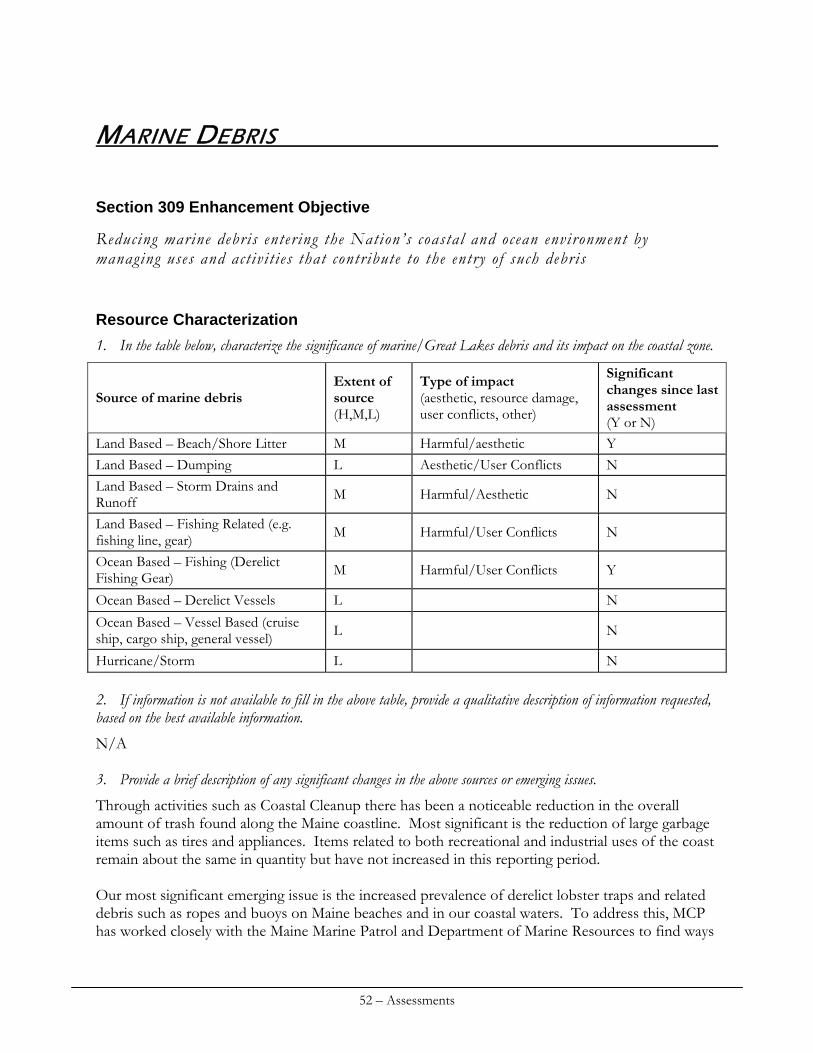
MARINE DEBRIS
Section 309 Enhancement Objective
Reducing marine debris entering the Nation’s coastal and ocean environment by managing uses and activit ies that contribute to the entry of such debris
Resource Characterization
1. In the table below, characterize the significance of marine/Great Lakes debris and its impact on the coastal zone.
Extent of source (H,M,L)
Type of impact (aesthetic, resource damage, user conflicts, other)
Significant changes since last assessment (Y or N)
Source of marine debris
Land Based – Beach/Shore Litter M Harmful/aesthetic Y Land Based – Dumping L Aesthetic/User Conflicts N Land Based – Storm Drains and Runoff M Harmful/Aesthetic N
Land Based – Fishing Related (e.g. fishing line, gear) M Harmful/User Conflicts N
Ocean Based – Fishing (Derelict Fishing Gear) M Harmful/User Conflicts Y
Ocean Based – Derelict Vessels L N Ocean Based – Vessel Based (cruise ship, cargo ship, general vessel) L N
Hurricane/Storm L N 2. If information is not available to fill in the above table, provide a qualitative description of information requested, based on the best available information.
N/A 3. Provide a brief description of any significant changes in the above sources or emerging issues.
Through activities such as Coastal Cleanup there has been a noticeable reduction in the overall amount of trash found along the Maine coastline. Most significant is the reduction of large garbage items such as tires and appliances. Items related to both recreational and industrial uses of the coast remain about the same in quantity but have not increased in this reporting period. Our most significant emerging issue is the increased prevalence of derelict lobster traps and related debris such as ropes and buoys on Maine beaches and in our coastal waters. To address this, MCP has worked closely with the Maine Marine Patrol and Department of Marine Resources to find ways
52 – Assessments
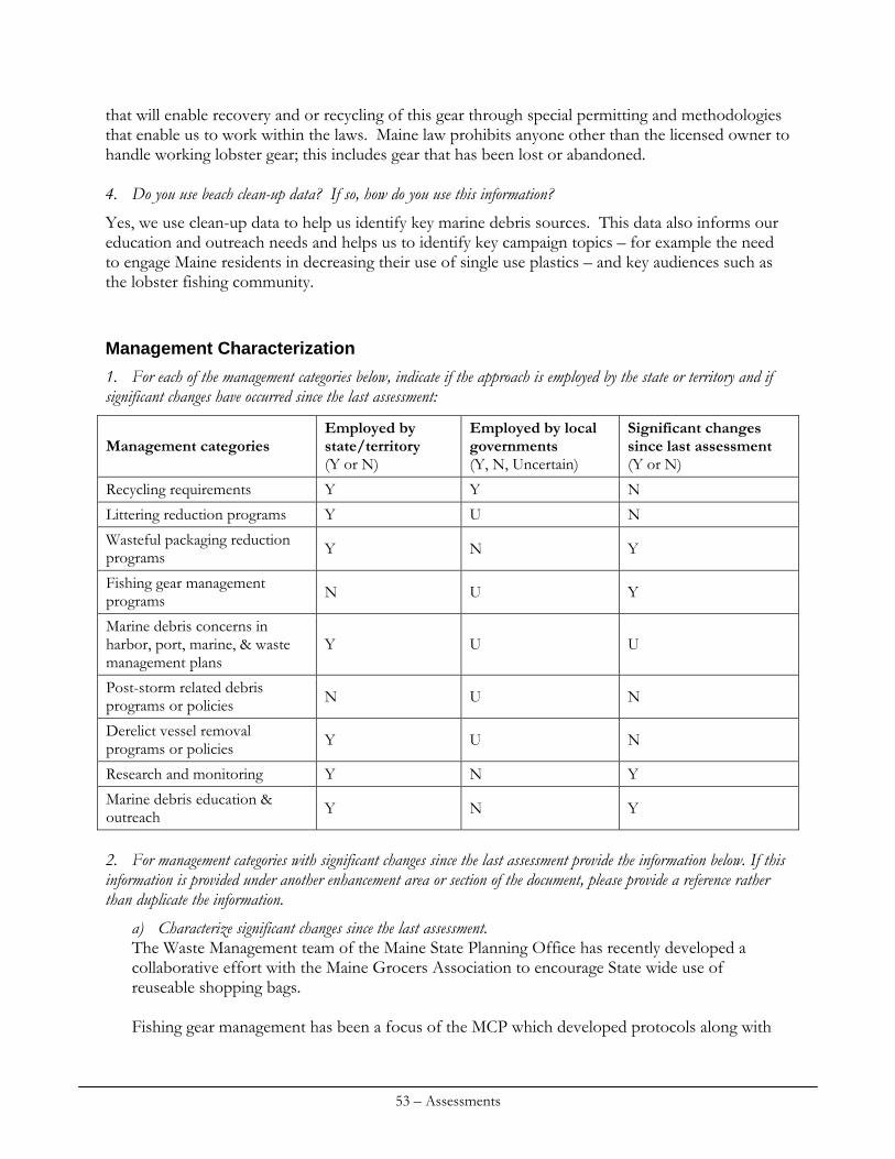
that will enable recovery and or recycling of this gear through special permitting and methodologies that enable us to work within the laws. Maine law prohibits anyone other than the licensed owner to handle working lobster gear; this includes gear that has been lost or abandoned. 4. Do you use beach clean-up data? If so, how do you use this information?
Yes, we use clean-up data to help us identify key marine debris sources. This data also informs our education and outreach needs and helps us to identify key campaign topics – for example the need to engage Maine residents in decreasing their use of single use plastics – and key audiences such as the lobster fishing community.
Management Characterization
1. For each of the management categories below, indicate if the approach is employed by the state or territory and if significant changes have occurred since the last assessment:
Employed by state/territory (Y or N)
Employed by local governments (Y, N, Uncertain)
Significant changes since last assessment (Y or N)
Management categories
Recycling requirements Y Y N
Littering reduction programs Y U N
Wasteful packaging reduction programs Y N Y
Fishing gear management programs N U Y
Marine debris concerns in harbor, port, marine, & waste management plans
Y U U
Post-storm related debris programs or policies N U N
Derelict vessel removal programs or policies Y U N
Research and monitoring Y N Y
Marine debris education & outreach Y N Y
2. For management categories with significant changes since the last assessment provide the information below. If this information is provided under another enhancement area or section of the document, please provide a reference rather than duplicate the information.
a) Characterize significant changes since the last assessment. The Waste Management team of the Maine State Planning Office has recently developed a collaborative effort with the Maine Grocers Association to encourage State wide use of reuseable shopping bags. Fishing gear management has been a focus of the MCP which developed protocols along with
53 – Assessments
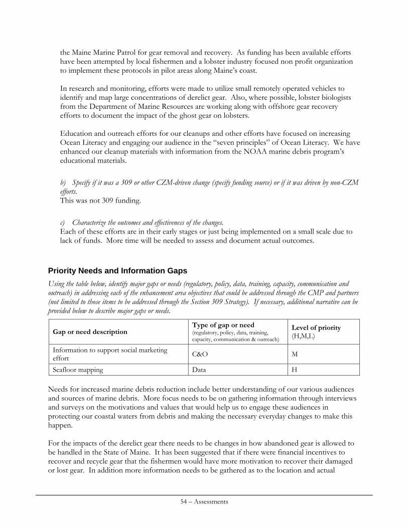
the Maine Marine Patrol for gear removal and recovery. As funding has been available efforts have been attempted by local fishermen and a lobster industry focused non profit organization to implement these protocols in pilot areas along Maine’s coast. In research and monitoring, efforts were made to utilize small remotely operated vehicles to identify and map large concentrations of derelict gear. Also, where possible, lobster biologists from the Department of Marine Resources are working along with offshore gear recovery efforts to document the impact of the ghost gear on lobsters. Education and outreach efforts for our cleanups and other efforts have focused on increasing Ocean Literacy and engaging our audience in the “seven principles” of Ocean Literacy. We have enhanced our cleanup materials with information from the NOAA marine debris program’s educational materials.
b) Specify if it was a 309 or other CZM-driven change (specify funding source) or if it was driven by non-CZM efforts. This was not 309 funding.
c) Characterize the outcomes and effectiveness of the changes. Each of these efforts are in their early stages or just being implemented on a small scale due to lack of funds. More time will be needed to assess and document actual outcomes.
Priority Needs and Information Gaps
Using the table below, identify major gaps or needs (regulatory, policy, data, training, capacity, communication and outreach) in addressing each of the enhancement area objectives that could be addressed through the CMP and partners (not limited to those items to be addressed through the Section 309 Strategy). If necessary, additional narrative can be provided below to describe major gaps or needs.
Type of gap or need (regulatory, policy, data, training, capacity, communication & outreach)
Level of priority (H,M,L) Gap or need description
Information to support social marketing effort C&O M
Seafloor mapping Data H Needs for increased marine debris reduction include better understanding of our various audiences and sources of marine debris. More focus needs to be on gathering information through interviews and surveys on the motivations and values that would help us to engage these audiences in protecting our coastal waters from debris and making the necessary everyday changes to make this happen. For the impacts of the derelict gear there needs to be changes in how abandoned gear is allowed to be handled in the State of Maine. It has been suggested that if there were financial incentives to recover and recycle gear that the fishermen would have more motivation to recover their damaged or lost gear. In addition more information needs to be gathered as to the location and actual
54 – Assessments
amount of gear that is currently in Maine coastal waters. Mapping of the sea floor would be helpful in gaining this needed information.
Enhancement Area Prioritization
1. What level of priority is the enhancement area for the coastal zone (including, but not limited to, CZMA funding)?
High Medium x Low
Marine debris, although problematic is not a widespread and persistent problem in Maine and can be addressed through existing programs and level of effort. 2. Will the CMP develop one or more strategies for this enhancement area?
Yes No x
MCP activities regarding marine debris are funded with Section 306 funds. MCP will continue to seek grants for land-based and underwater removal of derelict fishing gears. A project to further examine selected beaches where derelict gear gathers after storms and to conduct outreach to fishermen who work in that vicinity may be launched with Section 306 funds, in collaboration with the Maine Department of Marine Resources (DMR). DMR has indicated that regulatory solutions or new fees on fishing gear will stand a poor chance of passage in the current regulatory requirement, thus MCP’s reliance on education, voluntary stewardship and clean-ups.
55 – Assessments
56 – Assessments
OCEAN RESOURCES: 2
Section 309 Programmatic Objectives (from NOAA)
I. Develop and enhance regulations, plans and government coordination to provide for e f fec tive ocean resource management and ef f ic i ent decision-making.
II. Develop strategies and plans to balance the use and development of ocean resources; coordinate exist ing authorit ies ; and minimize use confl ic ts . Ocean management strategies should consider, where appropriate, the e f fects of act ivi t ies and uses on threatened and endangered species and their habitats. The designation of speci f i c marine protected areas should be considered.
Resource Characterization
The following section characterizes Maine’s ocean resources, identifies issues and uses of state concern, and specifies existing and anticipated threats or use conflicts.
Resource or Use Threat or Conflict
Degree of Threat High/Med/Low
Anticipated, Future Threat or Conflict
Marine Fisheries Some fisheries have been over harvested, and although significant reductions in effort have been achieved, the potential for rebuilding is not yet known. The lobster fishery is an anomaly, with continued record landings; however, the level of effort in the fishery remains a concern biologically, socially, and economically.
High Continued decline in fisheries threatens the structure and function of the Gulf of Maine ecosystem and the economic vitality of coastal communities. If rebuilding of depleted stocks is achieved, the challenge will be to limit future harvest to sustainable levels. For healthy fisheries, taking proactive steps is politically difficult. Coastal development will continue to impact water quality and fish habitat.
2 “Ocean resources” is a broad term encompassing all the living and non-living “public trust” resources that are held by
the state and managed on behalf of Maine citizens.
Research and monitoring programs target a small number of the marine species. Factors such as funding availability and source, resource status, management jurisdiction, value of the fishery, legislative mandates, and constituent interests determine the focus of state-sponsored research programs. Lack of information about marine resources delays/ inhibits the efficiency and accuracy of permitting decisions.
High Resource harvesters, environmental groups and others continue to call for “area-based” and “community-based” management of marine resources. New and better data and information and additional staff resources will be needed to implement this type of approach. Implementation of ecosystem-based management approaches will require retooling & new information. To facilitate marine spatial planning in Maine, additional resources will be needed to assess migration, biomass, habitat, and other critical species information to aid in stock health and decrease use conflict.
Ecological knowledge; monitoring and research
Use Conflicts Continued negative ecological impacts result from both land and water-based activities. Negative social impacts occur when two or more user groups want to use the same space and/or when there are competing ideas about appropriate uses of the marine environment. Additionally, confusion surrounding maritime boundaries – including federal, state, and municipal continue to create problems of taxation and jurisdiction.
High Competition between users is likely to increase as recreational and commercial markets expand. For example, rising recreational boat traffic may conflict with other uses such as aquaculture and commercial fishing. Large-scale energy & other projects may disrupt fixed gear locations, mobile gear tracts, and restrict or ban harvesting.
Dredging times of operation and duration
Coastal dredging may has the potential to have adverse effects on habitat and fisheries. To avoid and minimize the potential for adverse effects,
Medium
As federal resources available for maintenance of federal navigation projects decrease and the competitive nature of these funds increases,
57 – Assessments
Ocean Disposal of Dredged Materials
regulatory approvals identify times within which dredging may occur. These environmental dredging windows increase project-related cost by restricting times of operation and duration. The interim approval of the Cape Arundel Disposal Site (CADS) expired in 2010. There are no designated sites in Maine’s more easterly waters. Case by case designation of disposal sites or beneficial use options can be time consuming and controversial. Ocean disposal is precluded or limited when dredged material is contaminated with pollutants such as PAHs, PCBs, and metals.
Medium
some projects, particularly of a smaller nature will have difficulty getting any funding. The lack of established alternative(s) to CADS could increase the cost for or to both public and private dredging projects in southern Maine and New Hampshire. Federal agencies’ discretion regarding the appropriate testing for safe ocean disposal may create economic incentives to use sites in state waters, resulting in increased potential for local controversy.
Estuarine and Marine Habitats
A variety of human activities alter marine and estuarine habitats (e.g., docks and piers, shoreline alteration, nonpoint source pollution, fishing practices, cable and pipeline development, etc.). While Maine’s marine resources laws include the authority to implement harvesting closures and temporary closures for fisheries management, Maine lacks specific enabling legislation to enact broad-based marine protected areas.
High There will likely be an increase in the intensity and complexity of pro-posals for development involving marine & near-shore habitat alteration. Conservation groups, the federal government and others will continue to call for the establishment of a network of marine protected areas as a method to conserve important habitats and rebuild fish stocks. Maine’s proposed Integrated Beach Management Program proposes the use of beach nourishment as an erosion mitigation tool. Additional pressure on offshore sources of sand and gravel may result.
58 – Assessments
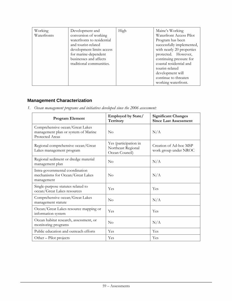
Development and conversion of working waterfronts to residential and tourist-related development limits access for marine-dependent businesses and affects traditional communities.
High Maine’s Working Waterfront Access Pilot Program has been successfully implemented, with nearly 20 properties protected. However, continuing pressure for coastal residential and tourist-related development will continue to threaten working waterfront.
Working Waterfronts
Management Characterization
1. Ocean management programs and initiatives developed since the 2006 assessment:
Employed by State/ Territory
Significant Changes Since Last Assessment Program Element
Comprehensive ocean/Great Lakes management plan or system of Marine Protected Areas
No N/A
Yes (participation in Northeast Regional Ocean Council)
Creation of Ad-hoc MSP work group under NROC
Regional comprehensive ocean/Great Lakes management program
Regional sediment or dredge material management plan No N/A
Intra-governmental coordination mechanisms for Ocean/Great Lakes management
No N/A
Single-purpose statutes related to ocean/Great Lakes resources Yes Yes
Comprehensive ocean/Great Lakes management statute No N/A
Ocean/Great Lakes resource mapping or information system Yes Yes
Ocean habitat research, assessment, or monitoring programs No N/A
Public education and outreach efforts Yes Yes
Other – Pilot projects Yes Yes
59 – Assessments
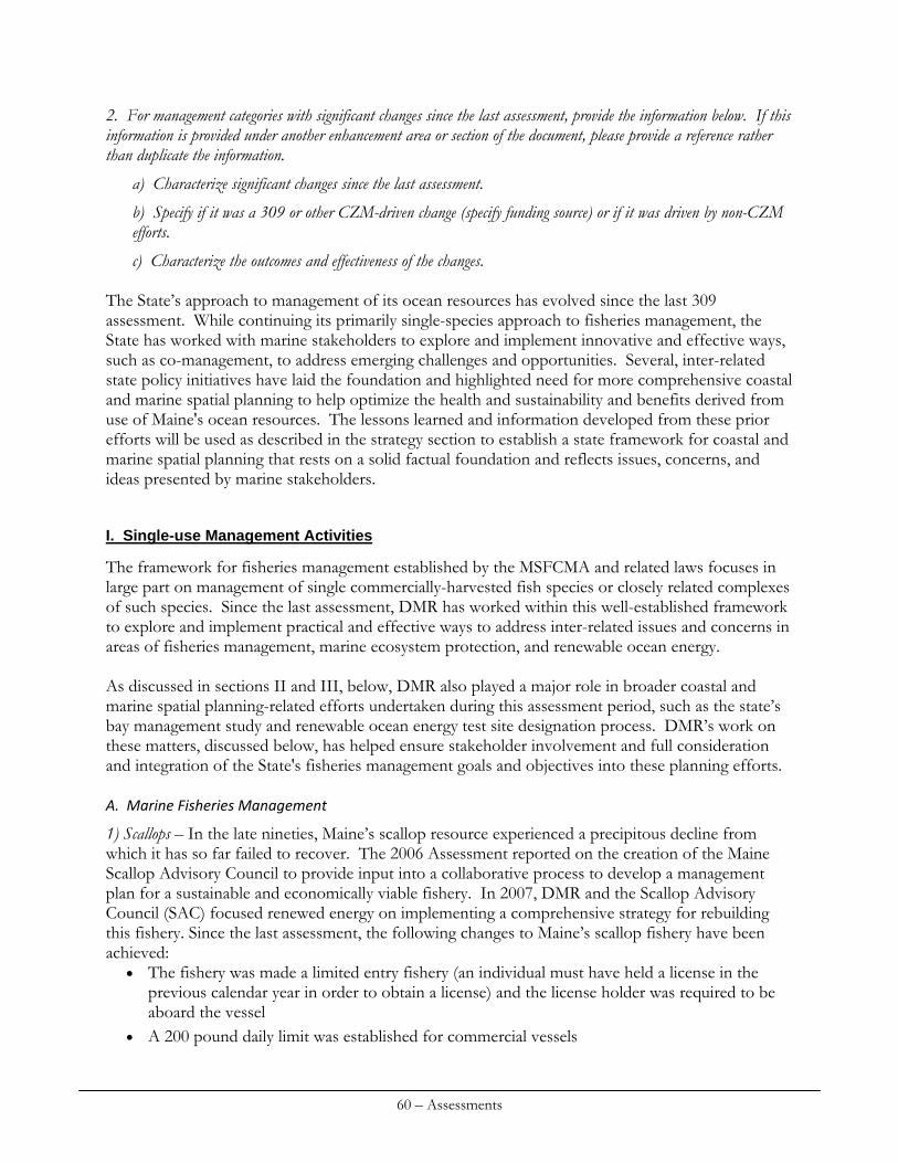
2. For management categories with significant changes since the last assessment, provide the information below. If this information is provided under another enhancement area or section of the document, please provide a reference rather than duplicate the information.
a) Characterize significant changes since the last assessment.
b) Specify if it was a 309 or other CZM-driven change (specify funding source) or if it was driven by non-CZM efforts.
c) Characterize the outcomes and effectiveness of the changes. The State’s approach to management of its ocean resources has evolved since the last 309 assessment. While continuing its primarily single-species approach to fisheries management, the State has worked with marine stakeholders to explore and implement innovative and effective ways, such as co-management, to address emerging challenges and opportunities. Several, inter-related state policy initiatives have laid the foundation and highlighted need for more comprehensive coastal and marine spatial planning to help optimize the health and sustainability and benefits derived from use of Maine's ocean resources. The lessons learned and information developed from these prior efforts will be used as described in the strategy section to establish a state framework for coastal and marine spatial planning that rests on a solid factual foundation and reflects issues, concerns, and ideas presented by marine stakeholders.
I. Single-use Management Activities
The framework for fisheries management established by the MSFCMA and related laws focuses in large part on management of single commercially-harvested fish species or closely related complexes of such species. Since the last assessment, DMR has worked within this well-established framework to explore and implement practical and effective ways to address inter-related issues and concerns in areas of fisheries management, marine ecosystem protection, and renewable ocean energy. As discussed in sections II and III, below, DMR also played a major role in broader coastal and marine spatial planning-related efforts undertaken during this assessment period, such as the state’s bay management study and renewable ocean energy test site designation process. DMR’s work on these matters, discussed below, has helped ensure stakeholder involvement and full consideration and integration of the State's fisheries management goals and objectives into these planning efforts. A. Marine Fisheries Management
1) Scallops – In the late nineties, Maine’s scallop resource experienced a precipitous decline from which it has so far failed to recover. The 2006 Assessment reported on the creation of the Maine Scallop Advisory Council to provide input into a collaborative process to develop a management plan for a sustainable and economically viable fishery. In 2007, DMR and the Scallop Advisory Council (SAC) focused renewed energy on implementing a comprehensive strategy for rebuilding this fishery. Since the last assessment, the following changes to Maine’s scallop fishery have been achieved:
The fishery was made a limited entry fishery (an individual must have held a license in the previous calendar year in order to obtain a license) and the license holder was required to be aboard the vessel
A 200 pound daily limit was established for commercial vessels
60 – Assessments
The season was reduced from 136 days to 70 days The minimum (drag) ring size was increased to 4 inches (from 3.5) Mandatory harvester reporting was implemented The non-commercial limit was decreased from one gallon to one half gallon of meats Ten three-year conservation closed areas were established Fines for violations of scallop conservation laws were increased significantly
These changes were enacted through both legislative and regulatory changes, and many stakeholders took part in the associated public hearings and community meetings. 2) Sea Urchins – Despite the dramatic season length reduction occurring in 2004 (from a statewide 90-day season to a 45-day season in Eastern Maine and a 10-day season in Western Maine), and reported in the 2006 Assessment, Maine’s urchin fishery has failed to recover. The reduction in the season was contentious, and attempts were made shortly after to circumvent the cuts made by DMR through rule-making by pursuing an expansion of the season through the Legislative process. DMR was able to prevent the passage of this bill, and has made incremental progress in the management of the fishery:
The composition of the Sea Urchin Zone Council was legislatively amended to reduce the number of Council members and to provide for the election of 7 of the 15 members by the industry
A 2-year conservation closed area was established in Cobscook Bay Rule-making for more detailed harvester reporting in Zone 1 has been initiated
3) Lobster – Since the 2006 Assessment, lobster landings have continued to increase, with record landings achieved in 2009. However, an essential collapse of the boat price in 2008 has many industry members concerned about future participation in the fishery. At the same time, increasing costs of fuel, further reductions in bait availability, and an unknown future with regard to reducing impacts on whales have added further stress, ensuring that the discussion of ways to ensure that the social and economic viability of the fishery will continue. Statutory and regulatory changes implemented since the last assessment include:
Legislative action to grant the Commissioner of DMR additional rule-making authority to regulate the use of alternative baits in the fishery, prompted by concerns that bait limitations would cause fishermen to seek new products that may pose risks to the lobster resource, the ecosystem, or public health and supporting regulations.
Legislative action to grant additional authorities to the lobster management policy councils to propose zone-specific rules to increase the enrollment period of the apprenticeship program, to require the sponsor of an apprentice to apprentice to have held a lobster license for at least 5 years and to limit entry to a zone to persons who have apprenticed in the zone and supporting regulations.
Legislative action to dramatically amend the laws governing entry into the fishery including making 17 the youngest age at which one can obtain a Class I, II or III commercial lobster and crab fishing license; creating a new lobster management policy council authority that would allow a zone to consider whether or not to create a separate waiting list for young people's entry into that zone; and changing the method for calculating a zone's exit-to-entry
61 – Assessments
ratio from lobster licenses not renewed to trap tags retired in the previous year and supporting regulations.
Legislative action to create a framework for island-specific limited entry programs, to address concerns raised about the impacts of license reductions on island communities.
Legislative action to increase the penalties for violations of lobster conservation laws. In addition to the co-management process that resulted in these successful legislative changes, a lengthy process to explore the feasibility of amending the license structure of the lobster fishery to account for different levels of individual effort was undertaken by the Lobster Advisory Council and DMR. The concepts developed were the subject of a series of Zone Council meetings during the summer of 2009, but failed to result in a legislative proposal. In 2008, the Governor created a Task Force on the Economic Sustainability of Maine’s Lobster Industry, which identified the potential for improved economic opportunity through a variety of strategies. Continued communication and outreach to the industry to build support for the Task Force recommendations is ongoing and likely to result in a legislative initiative in January 2011. The scallop, urchin, and lobster fisheries management strategies were supported by 309 funds. B. Marine Protected Areas
Growing understanding of the marine environment has broadened recognition that certain ocean areas, such a deep-water corals in the Gulf of Maine, host unique or uniquely productive ecosystems that may merit special management consideration and protection as marine protected areas. DMR Commissioner Lapointe served on the Marine Protected Areas Federal Advisory Committee (MPAFAC) since its inception in 2003, representing the interests of state resource management. During the 2006-10 assessment period, the MPAFAC met nine times and developed the recommendations for the implementation of a National System of Marine Protected Areas. The National System of MPAs provides coherence to the network of MPAs, to promote sustainable marine resource harvest, ecological integrity of marine systems, and the protection of marine cultural heritage. The National System also provides the foundation for future additions. Commissioner Lapointe served as co-chair of the Subcommittee on Incentives and Implementation, which addressed the importance of providing incentives for states to participate in the National System. States are critical partners in the effort to develop the National System, as nearly 80% of the nation’s marine managed areas are managed by states. Commissioner Lapointe’s service on the MPAFAC concluded in spring 2010. DMR’s work on the MPAFAC did not result in changes in coastal program laws and policies. This work did lay important ground work for linking subsequent Maine initiatives regarding marine protected areas with national ones, and initiated dialogue with stakeholders on ocean habitats of unique significance in Maine and the Gulf of Maine region and MPA-oriented approaches management of them. In addition, these preliminary considerations of MPAs as a management tool reinforced the importance of ensuring that designation and management of MPAs is assessed a broader planning contest that considers potential effects on commercial fishing and other existing uses.
62 – Assessments
II. Planning to Accommodate Potentially Competing Uses of Public Waters
A. Bay Management Study ‐ Intra‐state Regional Planning
The State’s 309-funded bay management study initiative was an outgrowth of the prior state aquaculture siting study. The aquaculture 309-funded study was a response to community concerns about siting net pens and other aquaculture facilities in near shore locations, particularly Blue Hill Bay in the Penobscot Bay region. Participants in the aquaculture study, which focused on issues and opportunities regarding a single-use (aquaculture) recognized the potential benefit of looking at how to manage coastal bays more holistically. Legislation enacted in response to recommendations from the aquaculture study (P.L. 2003 c. 660) included a directive to State’s Land and Water Resources Council (LWRC) to conduct a study of how to management bays in Maine in ways that minimized potential conflicts among users, and to submit a final report and recommendations in January 2007 to the Legislature’s Joint Standing Committee on Marine Resources. Following a roughly two-year study process, which included a series of meetings with stakeholders along the coast, the LWRC developed and submitted its final bay management report whose core recommendations were the following:
Encourage and support regional initiatives by providing:
o limited state support (e.g., workshop design and facilitation; data collection and interpretation; writing a management plan);
o funding or sustained support for specific projects; and
o encouraging inter-local agreements among municipalities and possibly state agencies to coordinate management of coastal resources and uses;
Increase the quality, quantity, and public accessibility of nearshore data and information by:
o creating and implement a long-term coastal marine science plan to identify and acquire needed data; and
o enhancing information exchange and marine geographic information systems;
Strengthen the framework for nearshore management as needed to achieve Maine’s coastal
vision and support regional initiatives by:
o implementing interagency coastal strategic planning;
o establishing a policy-level oversight committee; improving outreach; and
o conducting ongoing evaluation of nearshore management;
Increase the amount and diversity of funding sources for coastal and marine planning and
management; and
Support the implementation of the recommendations by maintaining current funding for existing priorities.
63 – Assessments
Overall, the bay management study highlighted importance and need for: local stakeholder involvement and related outreach and public education efforts to inform and
advance coastal resource planning; additional data and information, in a readily available format for public and private decision-
makers, to address gaps on key coastal and marine resources issues; planning at a scale appropriate to the issues under consideration and resources available, and
related difficulties in using individual coastal bays as the unit for state-level coastal and marine resources management and planning;
the reality of state funding constraints as a factor in determining the nature and scope of state coastal and marine resources management and planning; and
the value of coastal and marine spatial planning tools (e.g., use of maps and other graphical depictions of available information) for public engagement and decision-making focused on avoiding and minimizing conflicts among users and optimizing benefits to Maine of shared use of its marine environment.
In retrospect, these lessons-learned reveal that the bay management was the State’s first detailed effort to explore options for and first foray into the field of coastal and marine spatial planning (a term and concept not then widely discussed). In many ways, ocean resources strategies outlined below aim at addressing key issues, problems, and opportunities identified in the bay management study, with the objective of ensuring program improvements needed to integrate coastal and marine spatial planning in a manner well-suited to Maine. B. Taunton Bay Comprehensive Management Plan ‐ Local‐level scale; pilot projects
The State’s bay management study included two pilot projects (selected through an RFP process) aimed at modeling different ways to approach locally-driven regional planning regarding marine resources and related human uses in the State’s coastal bays. Then on-going community efforts to address conflict among uses and related community values (e.g., habitat conservation and urchin and seaweed harvesting) led to selection of the Taunton Bay pilot project, which illustrated the benefits and challenges of state-supported locally-driven coastal and marine planning and management. With considerable staff support provided by the DMR, the Taunton Bay Comprehensive Management Plan was completed in July 2007 and implemented soon after. DMR enacted rules to allow for a place-based system of user-defined individual quotas regarding several harvestable species within the Bay, including urchins, scallops, and mussels. DMR based these quotas on surveys conducted by harvesters under DMR’s oversight. Once these harvestable biomass assessments and harvester quotas were in place, the moratorium in Taunton Bay was lifted and commercial fishing resumed under the new parameters. DMR has undertaken several new studies in the Bay, including mussel seed assessments, eelgrass observations, and a water quality monitoring program. The above mentioned rules are scheduled to expire in December 2010. The Taunton Bay Advisory Group, an offshoot of the Management Plan, is currently devising a post-mandate strategy. Section 309 funds have supported the full range of the group's activities. The group’s final report will describe principles and lessons learned that may help bay or community-based ecosystem management elsewhere in Maine. The group is actively seeking new, self-sustaining sources of funding to continue its work.
64 – Assessments
Overall, state experience with this pilot project highlights: the funding and other challenges as well as the benefits of working at the local level; the potential, with adequate investment of time and money and detailed, place-specific
information, to develop more place-specific, ecosystem-oriented management criteria; and the importance of maintaining state perspective and authority regarding public trust resources.
C. Renewable ocean energy facilities siting – Designating Renewable Ocean Energy Demonstration Sites in Maine's Coastal Waters
In 2009, as required by P.L. 2009 chapter 270, DOC and SPO designated three areas in Maine’s coastal waters as ocean energy technology testing areas within which a qualified renewable ocean energy technology demonstration project could be sited, built, and operated under a DEP-administered general permit also created by the law. As a threshold step, DOC and SPO used existing data and spatial analysis tools to identify potential test areas that appeared to be technically suitable and to have minimal conflicts with or adverse effects on existing uses or resources. DOC and SPO then held over 30 small-scale, public scoping meetings with relevant stakeholders (harvesters, municipal officials, NGO’s, and pertinent federal agencies) to learn more about the areas and any concerns about their use as test areas. The agencies also held five regional meetings in coastal communities to inform the public about potential effects, siting processes, and related topics concerning the intended use of designated test areas and renewable ocean energy development generally. Establishment of these test areas directly supports and facilitates testing of renewable ocean energy technology and related growth of this emerging industry in Maine. This spatial analysis-based siting process has also given the MCP significant, real-world experience in use of spatial analysis as a coastal management tool and a template for public outreach and education that may be adapted to coastal and marine spatial planning at other scales. This initiative demonstrated the promise of spatial analysis, informed by best available data and information, including that provided by resource users and other stakeholders, as a tool for minimizing potential conflicts among and thus shared use of the marine environment. D. Regional‐scale coastal and marine planning ‐ NROC
The Gulf of Maine is large, complex ecosystem whose resources are shared among a diversifying host of traditional and emerging uses. There is broad and growing recognition of the need and potential benefit of addressing issues and resources of a regional nature from a regional perspective. For example, research needed to advance understanding of bird and bat migration through the Gulf of Maine touches on the interests of multiple states and stakeholders, including the nascent offshore wind industry, and may require action at scale or in areas beyond reach of a single state. At the same time, given the nature of our federalist system and related lack of well-established multi-state, regional governance institutions, it is clear that the effectiveness regional planning and management must depend in part on implementation at the state or more local level. During the assessment period, the MCP participated actively in regional coastal and marine resource management forums, chiefly the Northeast Regional Ocean Council (NROC), as a vehicle for addressing Gulf of Maine-wide concerns linked to Maine's coastal policies and related objectives.
65 – Assessments
1) Northeast Regional Ocean Council (NROC) – Created by the New England Governors in 2005, the Northeast Regional Ocean Council (NROC) facilitates progress and interstate cooperation on regional ocean concerns. NROC receives staff support from the National Ocean Service and in-kind staff time from its member organizations. NROC’s work supports three regional priorities: healthy ocean ecosystems; balanced ocean energy development; and storm-resilient coastal communities. Since the previous assessment, NROC has focused intently on regional marine spatial planning initiatives including increased collaboration on energy siting issues, coordinated research efforts, and significant efforts to understand the underlying coastal and marine ecosystems. NROC has received both regional and national attention for aligning its efforts with the goals and objectives articulated in the final report of the Council on Environmental Quality-led Interagency Ocean Policy Task Force and President Obama’s July 2010 Executive Order regarding implementation of its coastal and marine spatial planning-oriented recommendations. NROC is well-positioned to be a national leader in efforts to advance these recommendations. Consequently, NROC can continue to serve as a key tool in addressing regional aspects of Maine's coastal and marine planning.
III. Addressing data gaps - building a foundation for future planning and management
The data needs assessment in the LWRC’s bay management report detailed and highlighted the need to address gaps in key data as a foundation for sound planning and on-going improvement of the MCP’s policies and programs. Since the last assessment, the State has initiated efforts to address this need and thus provide the necessary foundation for its proposed CMSP strategy. A. Maine Coastal and Marine Atlas
Coastal management efforts since the last assessment, including designating ocean areas for testing emerging offshore wind technologies, have underscored the importance of the making the best available information available to inform public and private decisions regarding uses of the marine environment. The MCP is developing the Coastal Atlas for this fundamental purpose. The MCP assembled a comprehensive geospatial database of all existing and relevant coastal and marine spatial data as a key step in designation of renewable ocean energy test areas (see above). As outlined in the strategy section, below, this information will be supplemented, maintained, and made publicly available through an online data portal as the Maine Coastal and Marine Atlas. The Atlas and related data collection and research efforts provide a scientific foundation and powerful outreach and education tool for and are thus a key component of the MCP’s overall coastal and marine spatial planning strategy. B. Data collection and research to address key data gaps: Mapping benthic habitat
The MCP’s work on designation of renewable ocean energy test sites highlighted the lack of benthic mapping as a significant gap in existing information about Maine’s coastal waters and adjoining federal waters. This information is significant both from an engineering perspective concerned with construction-related site characteristics as well as a habitat conservation perspective. Recently, DMR and SPO used American Reinvestment and Recovery Act funds to purchase an OLEX multi-beam sonar mapping system. As outlined in the strategy section, this system will be used to gather information that will significantly enhance understanding of the benthic habitat in the Gulf of Maine
66 – Assessments
and thus aid in a variety of coastal management and planning efforts, including fisheries management and energy facilities siting. This data collection effort is also designed to develop protocols for working with marine harvesters to gather data that will be used to refine program policies.
IV. Summary
As Maine’s approach to management of its coastal resources has evolved since the last assessment, the MCP has developed tools and experience that position the state well to move forward with the set of inter-related coastal and marine spatial planning strategies outlined below. Lessons-learned since the last assessment highlight the importance of the following as key elements of effective coastal and marine spatial planning:
addressing key data and information gaps and making the best available information available to public and private decision makers;
involving well-informed harvesters and other stakeholders directly in making coastal management decisions;
minimizing potential conflicts and facilitating shared use of ocean waters areas to the extent practicable; and
planning at a scale appropriate to the issues under consideration. Strategy aimed at addressing these core issues and building on information compiled, lessons learned, and partnerships forged as the State’s approach to ocean resources management has evolved in complexity and scope since the last 309 assessment. New uses, particularly ocean energy and related infrastructure development, are driving the need for coastal and marine spatial planning in Maine. The national coastal and marine spatial planning initiative complements NRO’s pre-existing regional planning and management efforts and promises to provide a policy framework for state CMSP strategies outlined below.
Enhancement Area Prioritization
1. What level of priority is the enhancement area for the coastal zone (including, but not limited to, CZMA funding)?
x High Medium Low
Ocean resources management continues to be a high priority for the Maine Coastal Program due to increased user conflicts, emerging new uses, recently enacted legislation establishing state ocean energy policy, and closely related regional and national CMSP efforts. 2. Will the CMP develop one or more strategies for this enhancement area?
Yes x No
67 – Assessments
Coastal and marine spatial planning and fisheries co-management are the focus of the strategies included in this area.
68 – Assessments
PUBLIC ACCESS
Section 309 Enhancement Objective
Attain increased opportunities for public access, taking into account current and future public access needs, to coastal areas of recreational, historical , aesthetic , ecological , or cultural value.
Resource Characterization
Purpose: To determine the extent to which problems and opportunities exist with regard to the enhancement objective. 1. Characterize threats and conflicts to creating and maintaining public access in the coastal zone.
Degree of threat (H,M,L)
Describe trends or provide other statistics to characterize the threat and impact on access
Type(s) of access affected
Type of threat or conflict causing loss of access
H In general, coastal development and population growth in coastal towns outpaces that of inland towns.
Continual/ongoing disputes about public access to intertidal areas and trespass over upland beaches.
Traditional recreational and fishing access/ across private property
Private residential development (including conversion of public facilities to private)
H 20 miles of prime water dependent access still exists; trend towards loosening of water-dependent use zoning laws in some municipalities (Portland).
Commercial access Non-water dependent commercial/industrial uses of the waterfront (existing or conversion)
Erosion M Less than 40 miles of sandy beaches in Maine; 10% of beaches are highly susceptible to erosion; 50% are moderately susceptible to erosion.
Dry sand recreation area, beach access ramps and ROWs
Sea level rise/ Great Lake level change
H Limited analysis of additional 2 ft rise in sea level has potential for widespread inundation along sand beaches in southern and midcoast Maine.
Dry sand recrea-tion area. Infra-structure degrada-tion (docks, piers, boat launches) inundation of existing ROW’s and easements/ facilities.
69 – Assessments
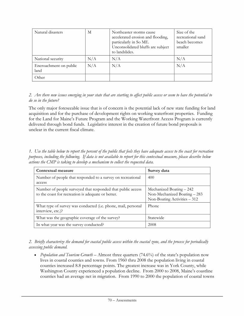
Natural disasters M Northeaster storms cause accelerated erosion and flooding, particularly in So ME. Unconsolidated bluffs are subject to landslides.
Size of the recreational sand beach becomes smaller
National security N/A N/A N/A
N/A N/A N/A Encroachment on public land
Other 2. Are there new issues emerging in your state that are starting to affect public access or seem to have the potential to do so in the future?
The only major foreseeable issue that is of concern is the potential lack of new state funding for land acquisition and for the purchase of development rights on working waterfront properties. Funding for the Land for Maine’s Future Program and the Working Waterfront Access Program is currently delivered through bond funds. Legislative interest in the creation of future bond proposals is unclear in the current fiscal climate. 1. Use the table below to report the percent of the public that feels they have adequate access to the coast for recreation purposes, including the following. If data is not available to report for this contextual measure, please describe below actions the CMP is taking to develop a mechanism to collect the requested data.
Contextual measure Survey data
400 Number of people that responded to a survey on recreational access
Mechanized Boating – 242 Non-Mechanized Boating – 283 Non-Boating Activities – 312
Number of people surveyed that responded that public access to the coast for recreation is adequate or better.
Phone What type of survey was conducted (i.e. phone, mail, personal interview, etc.)?
What was the geographic coverage of the survey? Statewide
In what year was the survey conducted? 2008 2. Briefly characterize the demand for coastal public access within the coastal zone, and the process for periodically assessing public demand.
Population and Tourism Growth – Almost three quarters (74.6%) of the state’s population now lives in coastal counties and towns. From 1960 thru 2008 the population living in coastal counties increased 8.8 percentage points. The greatest increase was in York County, while Washington County experienced a population decline. From 2000 to 2008, Maine’s coastline counties had an average net in migration. From 1990 to 2000 the population of coastal towns
70 – Assessments
grew approximately 6% to 565,645. Coastal population is expected to increase another 9% by the year 2015. The Maine coast is also a major draw for visitors. According to the Maine Office of Tourism, visitors made 15.4 million overnight trips and 16.5 million day visits to Maine in 2008. Of the overnight trips, 32% were to the southern Maine coast and 11% to Greater Portland/Casco Bay. In terms of day trips to these areas, the percentages are 27% and 16% respectively. Areas that consistently receive a large number of visitors include the southern coast and Mt. Desert Island (Acadia National Park.) While tourism growth fluctuates with national economic conditions, the Tourism Office expects that the number of visitors to the coast will rise over time.
Growth in Recreational Activities – The recreational use of coastal waters is still strong. According to surveys conducted by the Maine Department of Marine Resources and the National Marine Fisheries Service, the number of saltwater anglers in Maine reached 310,016 (120,842 were Maine residents) in 2008, then declined in 2010 to 290,357 (121,846). For example, in 2009, when there were approximately 453,318 saltwater anglers in Maine. These numbers fluctuate yearly, depending on the economy, weather and fishing interest, but sports fishermen remain substantial users of water access facilities.
Kayaking/Canoe Access – Maine’s long coastline and numerous islands continue to be an attraction for resident and nonresident kayak and canoe paddlers. A 2006 survey found that there were approximately 54,000 kayaking clients enjoying the services of sea kayaking guides. The 4,000 or so members of the Maine Island Trail Association have new destinations to look forward to as the Trail added six new sites in 2010.
Commercial Fishing – Commercial fishing continues to be a mainstay of the coastal economy. In 2004, the total number of licensed fishermen was 16,200 and the total value of landings was approximately $405 million (Department of Marine Resources).
Boat Registrations – While the number of registered boats in Maine fluctuates each year with the economy and the weather, registrations for 2010 is 96,461 recreational and commercial craft. An estimated 30% of these boaters use both inland and coastal waters.
Commercial and Recreational Boat Anchorage and Berthing Facilities – In a 2004 tracking survey of the 25 coastal communities originally surveyed in 2002, CEI found that the number of anchorages, berths, slips and tie-ups that support commercial fishing and recreational boating increased by 6% between 2002 and 2003. This tracking devise has not been applied since.
Recreational Survey Details and Update Process – MCP intends to complete a similar survey with questions geared towards assessment of the use of sites and document the findings in the proposed MCP Coastal Access Guide (planned release in 2012).
71 – Assessments
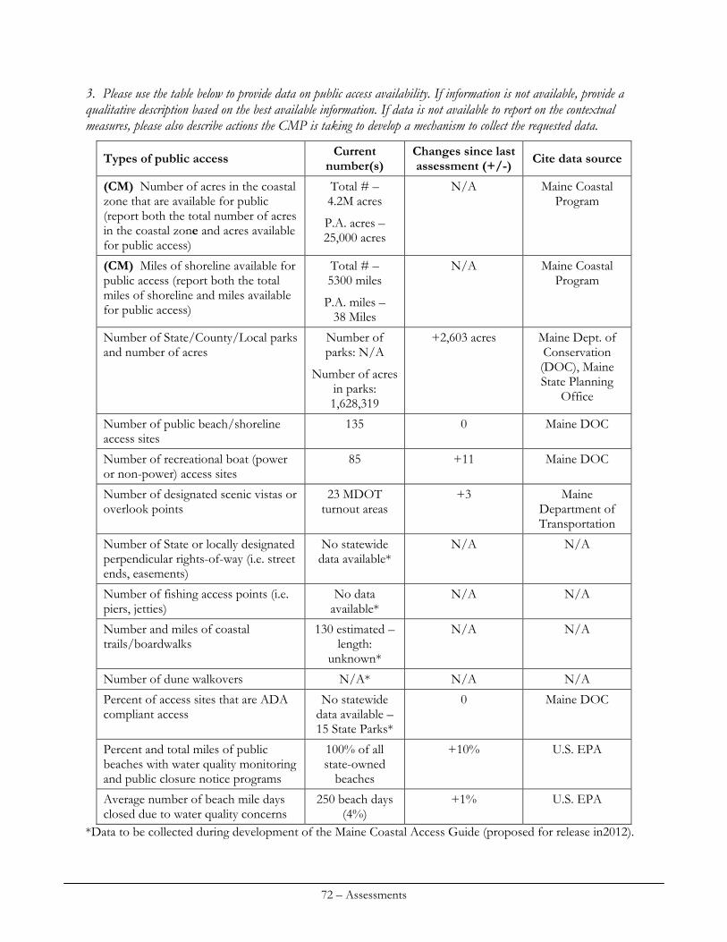
3. Please use the table below to provide data on public access availability. If information is not available, provide a qualitative description based on the best available information. If data is not available to report on the contextual measures, please also describe actions the CMP is taking to develop a mechanism to collect the requested data.
Current number(s)
Changes since last assessment (+/-) Cite data sourceTypes of public access
Total # – 4.2M acres
P.A. acres – 25,000 acres
N/A Maine Coastal Program
(CM) Number of acres in the coastal zone that are available for public (report both the total number of acres in the coastal zone and acres available for public access)
Total # – 5300 miles
P.A. miles – 38 Miles
N/A Maine Coastal Program
(CM) Miles of shoreline available for public access (report both the total miles of shoreline and miles available for public access)
Number of parks: N/A
Number of acres in parks: 1,628,319
+2,603 acres Maine Dept. of Conservation (DOC), Maine State Planning
Office
Number of State/County/Local parks and number of acres
135 0 Maine DOC Number of public beach/shoreline access sites
85 +11 Maine DOC Number of recreational boat (power or non-power) access sites
23 MDOT turnout areas
+3 Maine Department of Transportation
Number of designated scenic vistas or overlook points
No statewide data available*
N/A N/A Number of State or locally designated perpendicular rights-of-way (i.e. street ends, easements)
No data available*
N/A N/A Number of fishing access points (i.e. piers, jetties)
130 estimated – length:
unknown*
N/A N/A Number and miles of coastal trails/boardwalks
Number of dune walkovers N/A* N/A N/A
No statewide data available – 15 State Parks*
0 Maine DOC Percent of access sites that are ADA compliant access
100% of all state-owned
beaches
+10% U.S. EPA Percent and total miles of public beaches with water quality monitoring and public closure notice programs
250 beach days (4%)
+1% U.S. EPA Average number of beach mile days closed due to water quality concerns
*Data to be collected during development of the Maine Coastal Access Guide (proposed for release in2012).
72 – Assessments
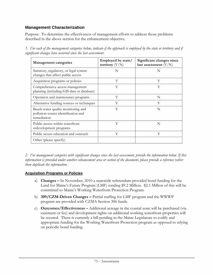
Management Characterization
Purpose: To determine the effectiveness of management efforts to address those problems described in the above section for the enhancement objective. 1. For each of the management categories below, indicate if the approach is employed by the state or territory and if significant changes have occurred since the last assessment:
Employed by state/ territory (Y/N)
Significant changes since last assessment (Y/N) Management categories
N N Statutory, regulatory, or legal system changes that affect public access
Acquisition programs or policies Y Y
Y Y Comprehensive access management planning (including GIS data or database)
Operation and maintenance programs Y N
Alternative funding sources or techniques Y Y
Y N Beach water quality monitoring and pollution source identification and remediation
Y N Public access within waterfront redevelopment programs
Public access education and outreach Y Y
Other (please specify) 2. For management categories with significant changes since the last assessment, provide the information below. If this information is provided under another enhancement area or section of the document, please provide a reference rather than duplicate the information.
Acquisition Programs or Policies
a) Changes – In November, 2010 a statewide referendum provided bond funding for the Land for Maine’s Future Program (LMF) totaling $9.2 Million. $2.1 Million of this will be committed to Maine’s Working Waterfront Protection Program.
b) 309/CZM-Driven Changes – Partial staffing for LMF program and the WWWP program are provided with CZMA Section 306 funds.
c) Outcomes/Effectiveness – Additional acreage in the coastal zone will be purchased (via easement or fee) and development rights on additional working waterfront properties will be secured. There is currently a bill pending in the Maine Legislature to codify and appropriate funding for the Working Waterfront Protection program as opposed to relying on periodic bond funding.
73 – Assessments
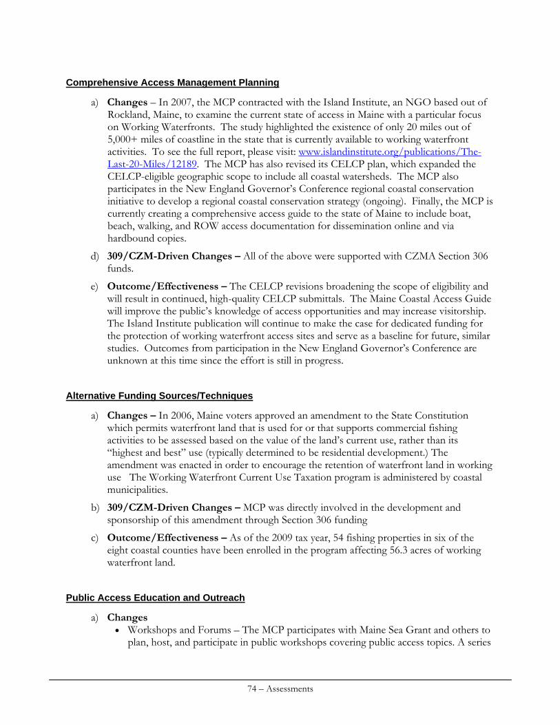
Comprehensive Access Management Planning
a) Changes – In 2007, the MCP contracted with the Island Institute, an NGO based out of Rockland, Maine, to examine the current state of access in Maine with a particular focus on Working Waterfronts. The study highlighted the existence of only 20 miles out of 5,000+ miles of coastline in the state that is currently available to working waterfront activities. To see the full report, please visit: www.islandinstitute.org/publications/The-Last-20-Miles/12189. The MCP has also revised its CELCP plan, which expanded the CELCP-eligible geographic scope to include all coastal watersheds. The MCP also participates in the New England Governor’s Conference regional coastal conservation initiative to develop a regional coastal conservation strategy (ongoing). Finally, the MCP is currently creating a comprehensive access guide to the state of Maine to include boat, beach, walking, and ROW access documentation for dissemination online and via hardbound copies.
d) 309/CZM-Driven Changes – All of the above were supported with CZMA Section 306 funds.
e) Outcome/Effectiveness – The CELCP revisions broadening the scope of eligibility and will result in continued, high-quality CELCP submittals. The Maine Coastal Access Guide will improve the public’s knowledge of access opportunities and may increase visitorship. The Island Institute publication will continue to make the case for dedicated funding for the protection of working waterfront access sites and serve as a baseline for future, similar studies. Outcomes from participation in the New England Governor’s Conference are unknown at this time since the effort is still in progress.
Alternative Funding Sources/Techniques
a) Changes – In 2006, Maine voters approved an amendment to the State Constitution which permits waterfront land that is used for or that supports commercial fishing activities to be assessed based on the value of the land’s current use, rather than its “highest and best” use (typically determined to be residential development.) The amendment was enacted in order to encourage the retention of waterfront land in working use The Working Waterfront Current Use Taxation program is administered by coastal municipalities.
b) 309/CZM-Driven Changes – MCP was directly involved in the development and sponsorship of this amendment through Section 306 funding
c) Outcome/Effectiveness – As of the 2009 tax year, 54 fishing properties in six of the eight coastal counties have been enrolled in the program affecting 56.3 acres of working waterfront land.
Public Access Education and Outreach
a) Changes Workshops and Forums – The MCP participates with Maine Sea Grant and others to
plan, host, and participate in public workshops covering public access topics. A series
74 – Assessments
of regional workshops covered the implementation of the working waterfront current use tax program and the working waterfront access protection pilot program.
Accessing the Maine Coast Website – Funded by a competitive grant from the National Sea Grant Law Center and lead by Maine Sea Grant in partnership with the Maine Coastal Program, The Center for Law and Innovation of the University of Maine School of law, and the Island Institute, a new website was created as a portal for information about the laws, programs, and information sources related to public access to the Maine coast.
Tax Policy and Working Access – Funded by another successful competitive grant from the National Sea Grant Law Center and lead by Maine Sea Grant in partnership with the Maine Coastal Program, The Center for Law and Innovation of the University of Maine School of Law, the Island Institute, and law firm of Bernstein Shur, this project is exploring the role of state and federal tax policies as an influence on protecting working access to the coast. Information will be incorporated into the Accessing the Maine Coast Website.
Working Waterfront Coalition – The Maine Coastal Program continues to be a vital part of the Working Waterfront Coalition, an informal coalition of 100 members comprised of agencies, NGOs, advocates, political leaders, fishermen, and others concerned about working access to the coast. The MCP represents the broad interests of the coalition in presentations, testimony before Congress, at national workshops, and other appropriate venues.
Maine Beaches Conference – Public access to beaches, intertidal rights, and working access to the coast were topics at the biennial conference, last held in 2009. Access to and use of Maine beaches continues to be a key public issue for coastal residents.
b) 309/CZM-Driven Changes – MCP staff and funding continue to support all of these initiatives, either through direct funding or through in-kind staff participation.
c) Outcomes/Effectiveness Workshops and Forums – Regional public access conferences provided information
to coastal residents about public access rights (and landowner rights): public laws, policies, and programs related to access, and a forum to identify and discuss emerging issues.
Accessing the Maine Coast Website – Viewed as a national model for state coastal access information.
Working Waterfront Coalition – Education about the need for the Working Waterfront program has resulted in funding appropriations. The Coalition MCP actively is currently working with members on the creation of a national coalition.
3. Indicate if your state of territory has a printed public access guide or website. How current is the publication and/or how frequently is the website updated? Please list any regional or statewide public access guide or websites.
Maine does not have a comprehensive, up-to-date guide or website for public access to the coast. Information about public access to the coast is scattered across agencies and organizations (and their publications and websites) and presented in the context of the individual program or otherwise reflects a particular organization’s mission. The MCP will be undertaking the development and publication of a comprehensive Access Guide to the coast of Maine, to be available in both hardcopy and online as both a PDF and as a data layer for the Maine Coastal Atlas. This guide will
75 – Assessments
document federal, state, local, and land trust coastal access sites throughout the state and provide facilities information for each site. Work is currently underway on the Guide and a tentative completion date is early 2012.
Priority Needs and Information Gaps
Using the table below, identify major gaps or needs (regulatory, policy, data, training, capacity, communication and outreach) in addressing each of the enhancement area objectives that could be addressed through the CMP and partners (not limited to those items to be addressed through the Section 309 Strategy). If necessary, additional narrative can be provided below to describe major gaps or needs.
Type of gap or need (regulatory, policy, data, training, capacity, communication & outreach)
Level of priority (H,M,L) Gap or need description
Data/Communications and Outreach H Conservation Lands and Access Database/Public Access Guide
N/A; (judicial) M Clarification of rights and needs in the intertidal and as they relate to recreational access
Progress has been made in compiling a statewide conservation lands data layer using GIS, however, the information does not include municipal and NGO lands and does not include information about access opportunities access infrastructure. An up-to-date and well-maintained public access and conservation lands inventory is essential to guide the efficient use of resources to insure adequate public access within the coastal zone. This data gap also makes it difficult to accurately report on the public access indicators for the National Coastal Management Performance Measurement System. The project described earlier in the section, The Maine Coastal Access Guide, will build on and enhance the conservation lands database. In the face of the increasing demands for waterfront properties, reliance on the traditional custom of passage over private lands to gain access to state waters is not an effective policy to ensure widespread public access to the shore. There is a need for more public access sites and facilities to meet public needs, a clarification of public trust rights in intertidal lands, and a need to work more closely with program partners to acquire priority lands that will provide boating access for recreation and commercial marine activities.
Enhancement Area Prioritization
1. What level of priority is the enhancement area for the coastal zone (including, but not limited to, CZMA funding)?
High Medium x Low
76 – Assessments
Briefly explain the level of priority given for this enhancement area. Absent the ability to develop new funding mechanisms for coastal access, in light of current fiscal priorities and given the success of existing access programs, coastal access is rated as a medium priority for the MCP in this assessment. 2. Will the CMP develop one or more strategies for this enhancement area?
Yes No x
Briefly explain why a strategy will or will not be developed for this enhancement area. Maine’s strategies for increasing public access do not, at this time, meet the criteria for Section 309 funding. See the strategies section of this document for further discussion.
77 – Assessments
78 – Assessments
SPECIAL AREA MANAGEMENT PLANNING
Section 309 Enhancement Objective
Preparing and implementing special area management plans 3 for important coastal areas
Resource Characterization
1. Identify geographic areas in the coastal zone subject to use conflicts that can be addressed through special area management plans (SAMP). Also include areas where SAMP have already been developed, but new issues or conflicts have developed that are not addressed through the current plan. If necessary, additional narrative can be provided below.
Geographic Area Major conflicts Is this an emerging or a long-standing conflict?
Maine state waters and adjacent federal OCS
Ocean energy siting Recent and emerging
All shorelands, but in particular sand beaches and wetlands
Impacts of climate change, sea level rise and coastal erosion; inadequate state and municipal adaptation planning and regulatory mechanisms.
Recent and emerging
Coastal Habitat Focus Areas Cumulative impacts of development
Long-standing
Priority Estuaries and shellfish growing areas
Land use practices degrade coastal water quality
Long-standing
3 The Coastal Zone Management Act (CZMA) defines a Special Area Management Plan (SAMP) as “a comprehensive plan providing for natural resource protection and reasonable coastal-dependent economic growth containing a detailed and comprehensive statement of policies; standards and criteria to guide public and private uses of lands and waters; and mechanisms for timely implementation in specific geographic areas within the coastal zone. In addition, SAMPs provide for increased specificity in protecting natural resources, reasonable coastal-dependent economic growth, improved protection of life and property in hazardous areas, including those areas likely to be affected by land subsidence, sea level rise, or fluctuating water levels of the Great Lakes, and improved predictability in governmental decision making.”
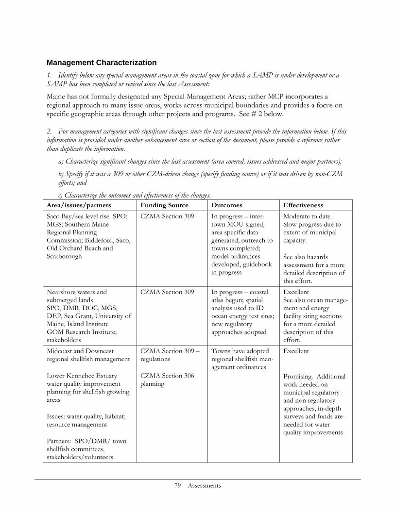
Management Characterization
1. Identify below any special management areas in the coastal zone for which a SAMP is under development or a SAMP has been completed or revised since the last Assessment:
Maine has not formally designated any Special Management Areas; rather MCP incorporates a regional approach to many issue areas, works across municipal boundaries and provides a focus on specific geographic areas through other projects and programs. See # 2 below. 2. For management categories with significant changes since the last assessment provide the information below. If this information is provided under another enhancement area or section of the document, please provide a reference rather than duplicate the information.
a) Characterize significant changes since the last assessment (area covered, issues addressed and major partners);
b) Specify if it was a 309 or other CZM-driven change (specify funding source) or if it was driven by non-CZM efforts; and
c) Characterize the outcomes and effectiveness of the changes. Area/issues/partners Funding Source Outcomes Effectiveness
CZMA Section 309 In progress – inter-town MOU signed; area specific data generated; outreach to towns completed; model ordinances developed, guidebook in progress
Moderate to date. Slow progress due to extent of municipal capacity. See also hazards assessment for a more detailed description of this effort.
Saco Bay/sea level rise SPO; MGS; Southern Maine Regional Planning Commission; Biddeford, Saco, Old Orchard Beach and Scarborough
Nearshore waters and submerged lands SPO, DMR, DOC, MGS, DEP, Sea Grant, University of Maine, Island Institute GOM Research Institute; stakeholders
CZMA Section 309 In progress – coastal atlas begun; spatial analysis used to ID ocean energy test sites; new regulatory approaches adopted
Excellent See also ocean manage-ment and energy facility siting sections for a more detailed description of this effort.
Midcoast and Downeast regional shellfish management Lower Kennebec Estuary water quality improvement planning for shellfish growing areas Issues: water quality, habitat; resource management Partners: SPO/DMR/ town shellfish committees, stakeholders/volunteers
CZMA Section 309 – regulations CZMA Section 306 planning
Towns have adopted regional shellfish man-agement ordinances
Excellent Promising. Additional work needed on municipal regulatory and non regulatory approaches, in-depth surveys and funds are needed for water quality improvements
79 – Assessments
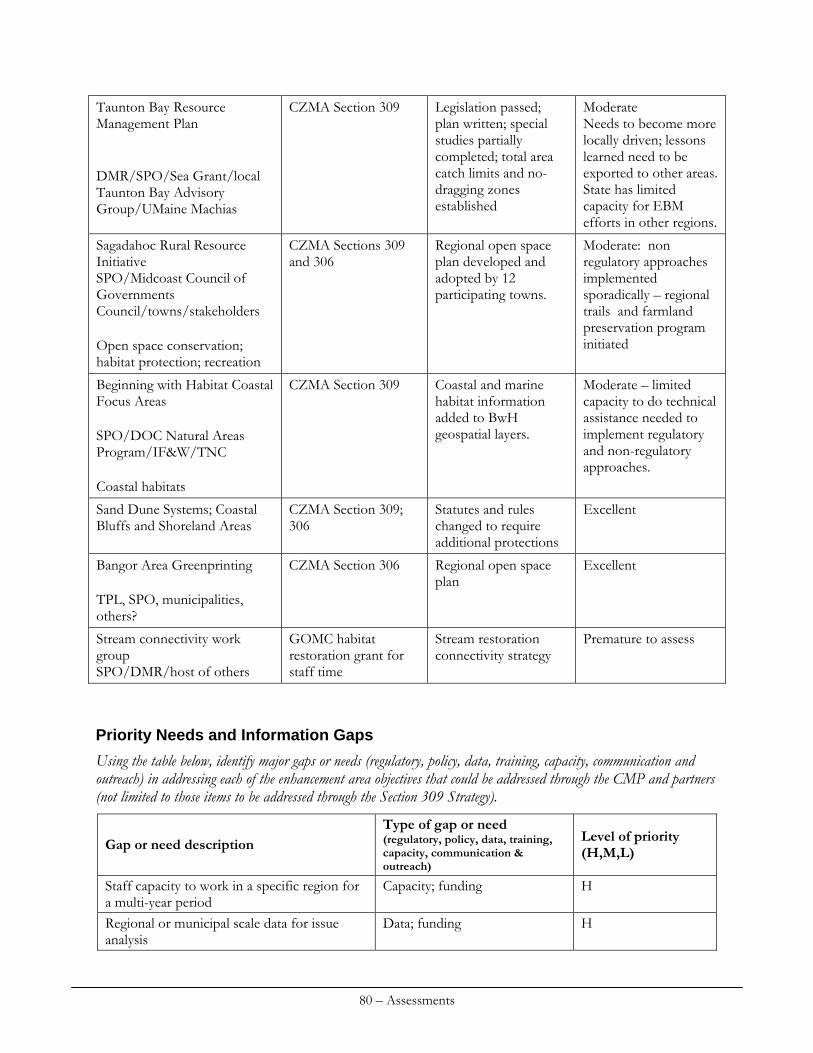
Taunton Bay Resource Management Plan DMR/SPO/Sea Grant/local Taunton Bay Advisory Group/UMaine Machias
CZMA Section 309 Legislation passed; plan written; special studies partially completed; total area catch limits and no-dragging zones established
Moderate Needs to become more locally driven; lessons learned need to be exported to other areas. State has limited capacity for EBM efforts in other regions.
Sagadahoc Rural Resource Initiative SPO/Midcoast Council of Governments Council/towns/stakeholders Open space conservation; habitat protection; recreation
CZMA Sections 309 and 306
Regional open space plan developed and adopted by 12 participating towns.
Moderate: non regulatory approaches implemented sporadically – regional trails and farmland preservation program initiated
Beginning with Habitat Coastal Focus Areas SPO/DOC Natural Areas Program/IF&W/TNC Coastal habitats
CZMA Section 309 Coastal and marine habitat information added to BwH geospatial layers.
Moderate – limited capacity to do technical assistance needed to implement regulatory and non-regulatory approaches.
CZMA Section 309; 306
Statutes and rules changed to require additional protections
Excellent Sand Dune Systems; Coastal Bluffs and Shoreland Areas
Bangor Area Greenprinting TPL, SPO, municipalities, others?
CZMA Section 306 Regional open space plan
Excellent
Stream connectivity work group SPO/DMR/host of others
GOMC habitat restoration grant for staff time
Stream restoration connectivity strategy
Premature to assess
Priority Needs and Information Gaps
Using the table below, identify major gaps or needs (regulatory, policy, data, training, capacity, communication and outreach) in addressing each of the enhancement area objectives that could be addressed through the CMP and partners (not limited to those items to be addressed through the Section 309 Strategy).
Type of gap or need (regulatory, policy, data, training, capacity, communication & outreach)
Level of priority (H,M,L) Gap or need description
Capacity; funding H Staff capacity to work in a specific region for a multi-year period Regional or municipal scale data for issue analysis
Data; funding H
80 – Assessments
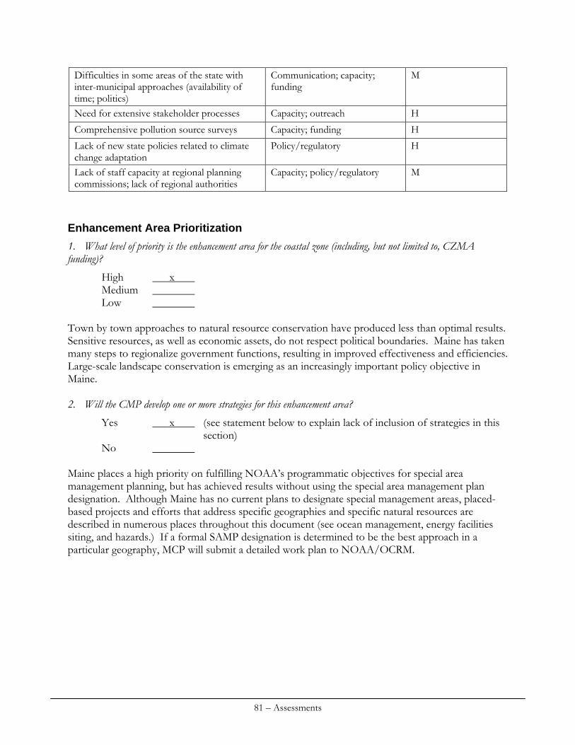
Communication; capacity; funding
M Difficulties in some areas of the state with inter-municipal approaches (availability of time; politics) Need for extensive stakeholder processes Capacity; outreach H
Comprehensive pollution source surveys Capacity; funding H
Policy/regulatory H Lack of new state policies related to climate change adaptation
Capacity; policy/regulatory M Lack of staff capacity at regional planning commissions; lack of regional authorities
Enhancement Area Prioritization
1. What level of priority is the enhancement area for the coastal zone (including, but not limited to, CZMA funding)?
High x Medium Low
Town by town approaches to natural resource conservation have produced less than optimal results. Sensitive resources, as well as economic assets, do not respect political boundaries. Maine has taken many steps to regionalize government functions, resulting in improved effectiveness and efficiencies. Large-scale landscape conservation is emerging as an increasingly important policy objective in Maine. 2. Will the CMP develop one or more strategies for this enhancement area?
Yes x (see statement below to explain lack of inclusion of strategies in this section) No
Maine places a high priority on fulfilling NOAA’s programmatic objectives for special area management planning, but has achieved results without using the special area management plan designation. Although Maine has no current plans to designate special management areas, placed-based projects and efforts that address specific geographies and specific natural resources are described in numerous places throughout this document (see ocean management, energy facilities siting, and hazards.) If a formal SAMP designation is determined to be the best approach in a particular geography, MCP will submit a detailed work plan to NOAA/OCRM.
81 – Assessments
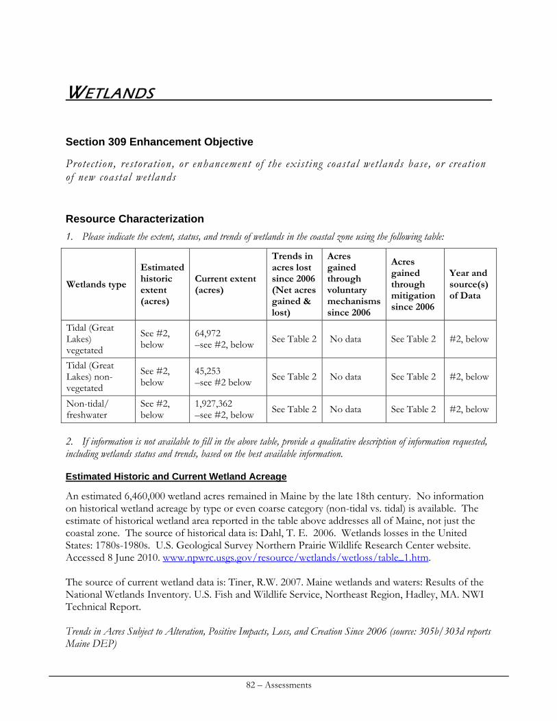
WETLANDS
Section 309 Enhancement Objective
Protect ion, restoration, or enhancement of the exist ing coastal wetlands base, or creation of new coastal wetlands
Resource Characterization
1. Please indicate the extent, status, and trends of wetlands in the coastal zone using the following table:
Estimated historic extent (acres)
Current extent (acres)
Trends in acres lost since 2006 (Net acres gained & lost)
Acres gained through voluntary mechanisms since 2006
Acres gained through mitigation since 2006
Year and source(s) of Data
Wetlands type
Tidal (Great Lakes) vegetated
See #2, below
64,972 –see #2, below See Table 2 No data See Table 2 #2, below
Tidal (Great Lakes) non-vegetated
See #2, below
45,253 –see #2 below See Table 2 No data See Table 2 #2, below
See #2, below
1,927,362 –see #2, below See Table 2 No data See Table 2 #2, below Non-tidal/
freshwater 2. If information is not available to fill in the above table, provide a qualitative description of information requested, including wetlands status and trends, based on the best available information.
Estimated Historic and Current Wetland Acreage
An estimated 6,460,000 wetland acres remained in Maine by the late 18th century. No information on historical wetland acreage by type or even coarse category (non-tidal vs. tidal) is available. The estimate of historical wetland area reported in the table above addresses all of Maine, not just the coastal zone. The source of historical data is: Dahl, T. E. 2006. Wetlands losses in the United States: 1780s-1980s. U.S. Geological Survey Northern Prairie Wildlife Research Center website. Accessed 8 June 2010. www.npwrc.usgs.gov/resource/wetlands/wetloss/table_1.htm. The source of current wetland data is: Tiner, R.W. 2007. Maine wetlands and waters: Results of the National Wetlands Inventory. U.S. Fish and Wildlife Service, Northeast Region, Hadley, MA. NWI Technical Report. Trends in Acres Subject to Alteration, Positive Impacts, Loss, and Creation Since 2006 (source: 305b/303d reports Maine DEP)
82 – Assessments
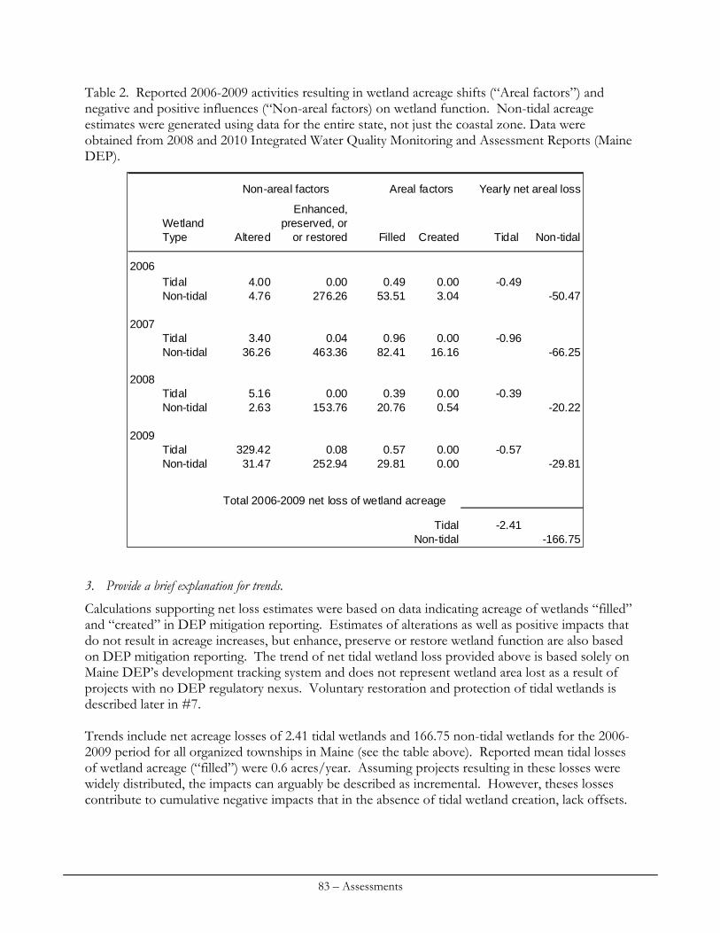
Table 2. Reported 2006-2009 activities resulting in wetland acreage shifts (“Areal factors”) and negative and positive influences (“Non-areal factors) on wetland function. Non-tidal acreage estimates were generated using data for the entire state, not just the coastal zone. Data were obtained from 2008 and 2010 Integrated Water Quality Monitoring and Assessment Reports (Maine DEP).
Enhanced,Wetland preserved, orType Altered or restored Filled Created Tidal Non-tidal
2006Tidal 4.00 0.00 0.49 0.00 -0.49Non-tidal 4.76 276.26 53.51 3.04 -50.47
2007Tidal 3.40 0.04 0.96 0.00 -0.96Non-tidal 36.26 463.36 82.41 16.16 -66.25
2008Tidal 5.16 0.00 0.39 0.00 -0.39Non-tidal 2.63 153.76 20.76 0.54 -20.22
2009Tidal 329.42 0.08 0.57 0.00 -0.57Non-tidal 31.47 252.94 29.81 0.00 -29.81
Total 2006-2009 net loss of wetland acreage
Tidal -2.41Non-tidal -166.75
Non-areal factors Areal factors Yearly net areal loss 3. Provide a brief explanation for trends.
Calculations supporting net loss estimates were based on data indicating acreage of wetlands “filled” and “created” in DEP mitigation reporting. Estimates of alterations as well as positive impacts that do not result in acreage increases, but enhance, preserve or restore wetland function are also based on DEP mitigation reporting. The trend of net tidal wetland loss provided above is based solely on Maine DEP’s development tracking system and does not represent wetland area lost as a result of projects with no DEP regulatory nexus. Voluntary restoration and protection of tidal wetlands is described later in #7. Trends include net acreage losses of 2.41 tidal wetlands and 166.75 non-tidal wetlands for the 2006-2009 period for all organized townships in Maine (see the table above). Reported mean tidal losses of wetland acreage (“filled”) were 0.6 acres/year. Assuming projects resulting in these losses were widely distributed, the impacts can arguably be described as incremental. However, theses losses contribute to cumulative negative impacts that in the absence of tidal wetland creation, lack offsets.
83 – Assessments
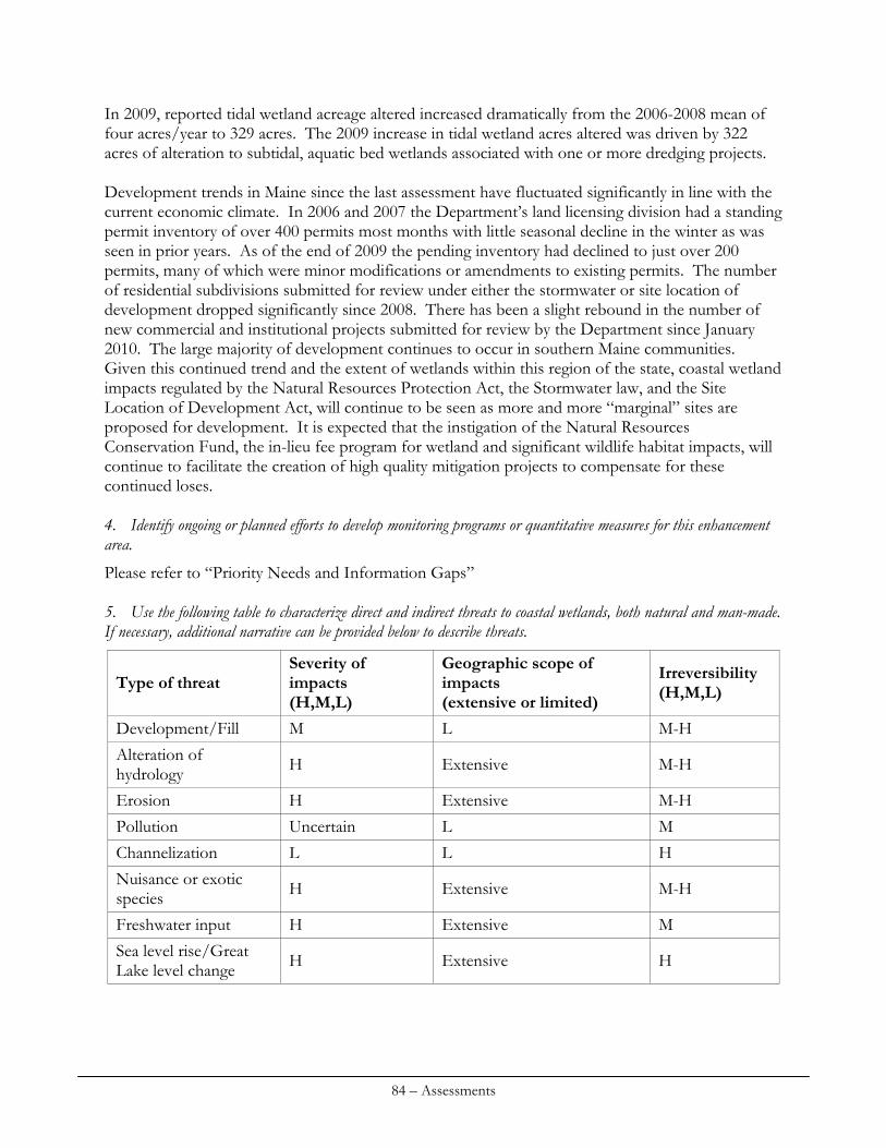
In 2009, reported tidal wetland acreage altered increased dramatically from the 2006-2008 mean of four acres/year to 329 acres. The 2009 increase in tidal wetland acres altered was driven by 322 acres of alteration to subtidal, aquatic bed wetlands associated with one or more dredging projects. Development trends in Maine since the last assessment have fluctuated significantly in line with the current economic climate. In 2006 and 2007 the Department’s land licensing division had a standing permit inventory of over 400 permits most months with little seasonal decline in the winter as was seen in prior years. As of the end of 2009 the pending inventory had declined to just over 200 permits, many of which were minor modifications or amendments to existing permits. The number of residential subdivisions submitted for review under either the stormwater or site location of development dropped significantly since 2008. There has been a slight rebound in the number of new commercial and institutional projects submitted for review by the Department since January 2010. The large majority of development continues to occur in southern Maine communities. Given this continued trend and the extent of wetlands within this region of the state, coastal wetland impacts regulated by the Natural Resources Protection Act, the Stormwater law, and the Site Location of Development Act, will continue to be seen as more and more “marginal” sites are proposed for development. It is expected that the instigation of the Natural Resources Conservation Fund, the in-lieu fee program for wetland and significant wildlife habitat impacts, will continue to facilitate the creation of high quality mitigation projects to compensate for these continued loses. 4. Identify ongoing or planned efforts to develop monitoring programs or quantitative measures for this enhancement area.
Please refer to “Priority Needs and Information Gaps” 5. Use the following table to characterize direct and indirect threats to coastal wetlands, both natural and man-made. If necessary, additional narrative can be provided below to describe threats.
Severity of impacts (H,M,L)
Geographic scope of impacts (extensive or limited)
Irreversibility (H,M,L)
Type of threat
Development/Fill M L M-H
Alteration of hydrology
H Extensive M-H
Erosion H Extensive M-H
Pollution Uncertain L M
Channelization L L H
Nuisance or exotic species
H Extensive M-H
Freshwater input H Extensive M
Sea level rise/Great Lake level change
H Extensive H
84 – Assessments
Development/Alteration of Hydrology.
A significant majority of threats to coastal wetlands originate from historic environmental impacts including wetland filling, channelization, and alteration of hydrology. Current wetland regulations have more stringent thresholds that prevent, mitigate, or compensate impacts to coastal wetlands. As a result, development activities such as wetland filling or alterations to hydrology are far less common that in the past - certainly in terms of magnitude. However, the legacy impacts associated with these previous activities are ongoing and in some cases (such as where causeways were constructed across wetlands) highly irreversible, which threatens the resilience of these systems to increased development and environmental shifts associated with climate change. At the many other sites of impaired flow in Maine’s coastal wetlands that would benefit greatly from even moderately restored flow regimes, there is little capacity to implement these corrections. Erosion.
Despite decades of diligent effort resulting in considerable progress, ongoing erosion and transport of fine sediments that accumulate in estuaries and reduce water clarity remains an issue warranting intervention. Additionally, historically-deposited sediments, which are subject to resuspension, may represent an ongoing legacy impact to water quality in shallow estuaries. It is also likely that increased run-off associated anticipated as a result of more frequent and intense precipitation events will lead to increased erosion, unless stormwater control efforts successfully meet this emerging challenge. Pollution.
The State of Maine has a unique biological monitoring program for wetlands and is currently in its first year of attainment of water quality standards under its administration of the Clean Water Act. However, biomonitoring criteria for estuarine waters are still in development, so the impacts of pollution from nutrient loading in these waters have not been adequately assessed. Programs to assess and monitor toxic pollutants have been subject to dramatic cuts in capacity, further limiting the ability to adequately characterize the effects of pollution. Nuisance and Exotic Species/Freshwater Input.
This threat is particularly high although the irreversibility varies. For invasive plants such as Phragmites, action can be taken to reverse conditions favorable to monopolization of existing marsh acreage. Freshwater inputs, which are projected as an increasing threat in the coming decades, are notably implicated in nuisance plant infestations such as represented by Phragmites, so efforts to reverse or slow the spread of these plants will in part rely on effective stormwater measures. Likewise, restoration or improvement of tidal flow is another important element of invasive plant management on marshes. Consequently, the rate of projects intending to restore tidal flow, which is currently hindered by low capacity, must be increased to compliment growing effectiveness of stormwater management if resiliency of coastal wetlands is to be enhanced. Marine invasives, including several highly invasive colonial tunicate species and the Asian shore crab represent high threats to coastal systems. At this time, it appears there are no effective methods for controlling the spread of these invasives.
85 – Assessments
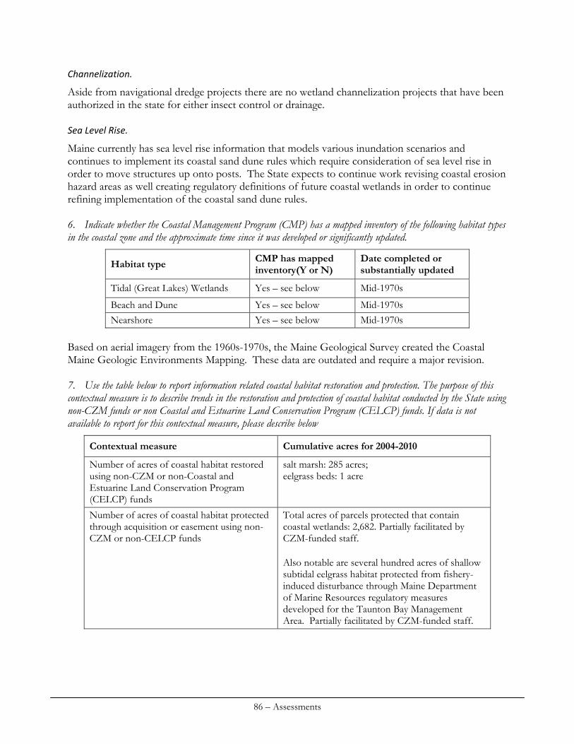
Channelization.
Aside from navigational dredge projects there are no wetland channelization projects that have been authorized in the state for either insect control or drainage. Sea Level Rise.
Maine currently has sea level rise information that models various inundation scenarios and continues to implement its coastal sand dune rules which require consideration of sea level rise in order to move structures up onto posts. The State expects to continue work revising coastal erosion hazard areas as well creating regulatory definitions of future coastal wetlands in order to continue refining implementation of the coastal sand dune rules. 6. Indicate whether the Coastal Management Program (CMP) has a mapped inventory of the following habitat types in the coastal zone and the approximate time since it was developed or significantly updated.
CMP has mapped inventory(Y or N)
Date completed or substantially updated Habitat type
Tidal (Great Lakes) Wetlands Yes – see below Mid-1970s
Beach and Dune Yes – see below Mid-1970s Nearshore Yes – see below Mid-1970s
Based on aerial imagery from the 1960s-1970s, the Maine Geological Survey created the Coastal Maine Geologic Environments Mapping. These data are outdated and require a major revision. 7. Use the table below to report information related coastal habitat restoration and protection. The purpose of this contextual measure is to describe trends in the restoration and protection of coastal habitat conducted by the State using non-CZM funds or non Coastal and Estuarine Land Conservation Program (CELCP) funds. If data is not available to report for this contextual measure, please describe below
Contextual measure Cumulative acres for 2004-2010
salt marsh: 285 acres; eelgrass beds: 1 acre
Number of acres of coastal habitat restored using non-CZM or non-Coastal and Estuarine Land Conservation Program (CELCP) funds Number of acres of coastal habitat protected through acquisition or easement using non-CZM or non-CELCP funds
Total acres of parcels protected that contain coastal wetlands: 2,682. Partially facilitated by CZM-funded staff. Also notable are several hundred acres of shallow subtidal eelgrass habitat protected from fishery-induced disturbance through Maine Department of Marine Resources regulatory measures developed for the Taunton Bay Management Area. Partially facilitated by CZM-funded staff.
86 – Assessments
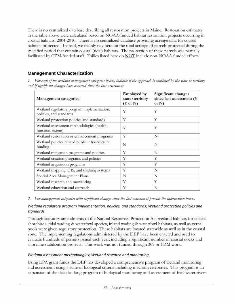
There is no centralized database describing all restoration projects in Maine. Restoration estimates in the table above were calculated based on NOAA-funded habitat restoration projects occurring in coastal habitats, 2004-2010. There is no centralized database providing acreage data for coastal habitats protected. Instead, we mainly rely here on the total acreage of parcels protected during the specified period that contain coastal (tidal) habitats. The protection of these parcels was partially facilitated by CZM-funded staff. Tallies listed here do NOT include non-NOAA funded efforts.
Management Characterization
1. For each of the wetland management categories below, indicate if the approach is employed by the state or territory and if significant changes have occurred since the last assessment:
Employed by state/territory (Y or N)
Significant changes since last assessment (Y or N)
Management categories
Wetland regulatory program implementation, policies, and standards Y Y
Wetland protection policies and standards Y Y Wetland assessment methodologies (health, function, extent) Y Y
Wetland restoration or enhancement programs Y N Wetland policies related public infrastructure funding N N
Wetland mitigation programs and policies Y N Wetland creation programs and policies Y Y Wetland acquisition programs Y Y Wetland mapping, GIS, and tracking systems Y N Special Area Management Plans N N Wetland research and monitoring Y Y Wetland education and outreach Y N
2. For management categories with significant changes since the last assessment provide the information below.
Wetland regulatory program implementation, policies, and standards; Wetland protection policies and standards.
Through statutory amendments to the Natural Resources Protection Act wetland habitats for coastal shorebirds, tidal wading & waterfowl species, inland wading & waterfowl habitats, as well as vernal pools were given regulatory protection. These habitats are located statewide as well as in the coastal zone. The implementing regulations administered by the DEP have been enacted and used to evaluate hundreds of permits issued each year, including a significant number of coastal docks and shoreline stabilization projects. This work was not funded through 309 or CZM work. Wetland assessment methodologies; Wetland research and monitoring.
Using EPA grant funds the DEP has developed a comprehensive program of wetland monitoring and assessment using a suite of biological criteria including macroinvertebrates. This program is an expansion of the decades-long program of biological monitoring and assessment of freshwater rivers
87 – Assessments
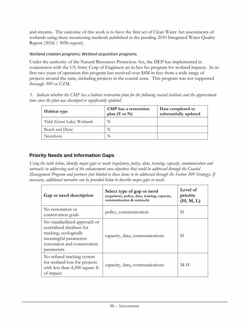
and streams. The outcome of this work is to have the first set of Clean Water Act assessments of wetlands using these monitoring methods published in the pending 2010 Integrated Water Quality Report (303d / 305b report). Wetland creation programs; Wetland acquisition programs.
Under the authority of the Natural Resources Protection Act, the DEP has implemented in conjunction with the US Army Corp of Engineers an in-lieu fee program for wetland impacts. In its first two years of operation this program has received over $4M in fees from a wide range of projects around the state, including projects in the coastal zone. This program was not supported through 309 or CZM. 3. Indicate whether the CMP has a habitat restoration plan for the following coastal habitats and the approximate time since the plan was developed or significantly updated.
CMP has a restoration plan (Y or N)
Date completed or substantially updated Habitat type
Tidal (Great Lake) Wetlands N
Beach and Dune N Nearshore N
Priority Needs and Information Gaps
Using the table below, identify major gaps or needs (regulatory, policy, data, training, capacity, communication and outreach) in addressing each of the enhancement area objectives that could be addressed through the Coastal Management Program and partners (not limited to those items to be addressed through the Section 309 Strategy). If necessary, additional narrative can be provided below to describe major gaps or needs.
Select type of gap or need (regulatory, policy, data, training, capacity, communication & outreach)
Level of priority (H, M, L)
Gap or need description
No restoration or conservation goals
policy, communication H
No standardized approach or centralized database for tracking, ecologically meaningful parameters restoration and conservation parameters
capacity, data, communications H
No refined tracking system for wetland loss for projects with less than 4,300 square ft of impact
capacity, data, communications M-H
88 – Assessments
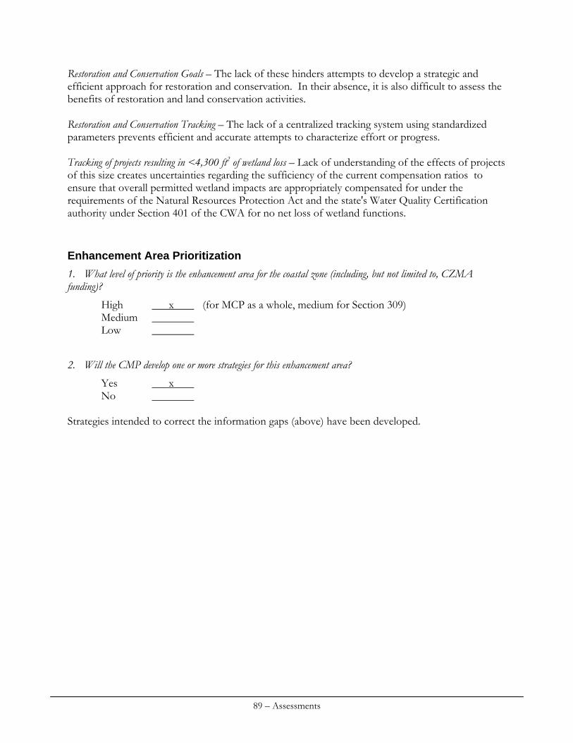
Restoration and Conservation Goals – The lack of these hinders attempts to develop a strategic and efficient approach for restoration and conservation. In their absence, it is also difficult to assess the benefits of restoration and land conservation activities. Restoration and Conservation Tracking – The lack of a centralized tracking system using standardized parameters prevents efficient and accurate attempts to characterize effort or progress. Tracking of projects resulting in <4,300 ft2 of wetland loss – Lack of understanding of the effects of projects of this size creates uncertainties regarding the sufficiency of the current compensation ratios to ensure that overall permitted wetland impacts are appropriately compensated for under the requirements of the Natural Resources Protection Act and the state's Water Quality Certification authority under Section 401 of the CWA for no net loss of wetland functions.
Enhancement Area Prioritization
1. What level of priority is the enhancement area for the coastal zone (including, but not limited to, CZMA funding)?
High x (for MCP as a whole, medium for Section 309) Medium Low
2. Will the CMP develop one or more strategies for this enhancement area?
Yes x No
Strategies intended to correct the information gaps (above) have been developed.
89 – Assessments

90 – Assessments
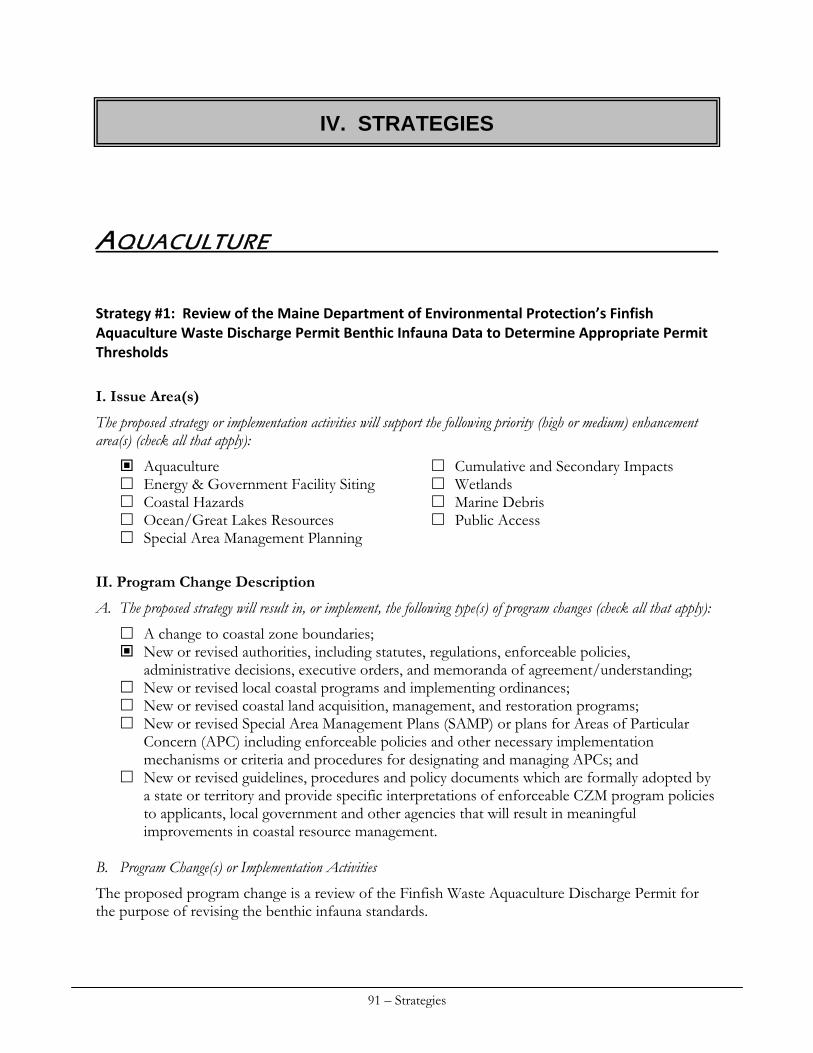
IV. STRATEGIES
AQUACULTURE
Strategy #1: Review of the Maine Department of Environmental Protection’s Finfish Aquaculture Waste Discharge Permit Benthic Infauna Data to Determine Appropriate Permit Thresholds
I. Issue Area(s)
The proposed strategy or implementation activities will support the following priority (high or medium) enhancement area(s) (check all that apply):
Aquaculture Cumulative and Secondary Impacts Energy & Government Facility Siting Wetlands Coastal Hazards Marine Debris Ocean/Great Lakes Resources Public Access Special Area Management Planning
II. Program Change Description
A. The proposed strategy will result in, or implement, the following type(s) of program changes (check all that apply):
A change to coastal zone boundaries; New or revised authorities, including statutes, regulations, enforceable policies,
administrative decisions, executive orders, and memoranda of agreement/understanding; New or revised local coastal programs and implementing ordinances; New or revised coastal land acquisition, management, and restoration programs; New or revised Special Area Management Plans (SAMP) or plans for Areas of Particular
Concern (APC) including enforceable policies and other necessary implementation mechanisms or criteria and procedures for designating and managing APCs; and
New or revised guidelines, procedures and policy documents which are formally adopted by a state or territory and provide specific interpretations of enforceable CZM program policies to applicants, local government and other agencies that will result in meaningful improvements in coastal resource management.
B. Program Change(s) or Implementation Activities
The proposed program change is a review of the Finfish Waste Aquaculture Discharge Permit for the purpose of revising the benthic infauna standards.
91 – Strategies
III. Need(s) and Gap(s) Addressed
This strategy addresses the priority need to review the Finfish Aquaculture Waste Discharge Permit for scientific validity and regulatory efficacy. The initial permit standards were put into place in 2003 with four monitoring parameters and permit thresholds. In 2008, those permit standards were modified where any single exceedance of a parameter was deemed a violation and some permit thresholds were reduced. Field sampling was conducted under this permit for the first time in the fall of 2009. All farms sampled in the fall of 2009 were found to be in violation of at least one of the 2008 permit standards and hence deemed to be in violation of their MePDES permits. Some farms deemed to be in violation appeared to be in more than acceptable environmental condition based on underwater video review, abundant epibenthic fauna and sediment chemistries. The benthic infauna sampling was the sole driver of permit violations. Subsequent review of historic infauna sampling showed that of the 44 sampling events from 2003 to 2009, all would have been in violation of their permit had the 2008 standards been in place. Worse, some baseline sampling of locations where farms were merely proposed but not yet permitted or installed (ambient natural conditions) also would have failed. Clearly the 2008 permit standards are not realistic.
IV. Benefit(s) to Coastal Management
This will ensure that finfish aquaculture is managed with standards that protect the marine environment while providing aquaculture opportunities in Maine.
V. Likelihood of Success
Examination of past farm practices and conditions, comparing historical benthic infauna data with potential permit thresholds and reaching consensus on what constitutes acceptable farm conditions should lead to a much improved permit. As currently written, the 2008 permit defines all sites (farmed and natural) as unacceptable. The likelihood of success in developing an improved (if still imperfect) permit is almost certain.
VI. Strategy Work Plan
Total Years: 1 Total Budget: $20,000 Final Outcome(s) and Products: Revised permit standards Year: 1 Description of activities: Staff will conduct meetings and perform data analysis to identify meaningful and acceptable permit levels for benthic infauna samples. Outside experts in benthic ecology may need to be consulted. Outcome(s): Revised permit standards Budget: $20,000
92 – Strategies
VII. Fiscal and Technical Needs
A. Fiscal Needs:
Considerable investment has been made over the years supporting the Finfish Aquaculture Monitoring Program. Initially, the program was funded by a penny/pound tax paid by aquaculturists to support the monitoring work. Now, aquaculturists are responsible for providing data requested to the State’s specifications. This strategy is a supplementary effort to refine the permitting process with appropriate standards. B. Technical Needs:
The State may need to consult with outside experts in benthic ecology to carry out this strategy. Strategy #2: Assessing the Impacts of Suspended Oyster Aquaculture Methods on Eelgrass (Zostera marina) Beds (shading, nutrient enrichment, etc.)
I. Issue Area(s)
The proposed strategy or implementation activities will support the following priority (high or medium) enhancement area(s) (check all that apply):
Aquaculture Cumulative and Secondary Impacts Energy & Government Facility Siting Wetlands Coastal Hazards Marine Debris Ocean/Great Lakes Resources Public Access Special Area Management Planning
II. Program Change Description
A. The proposed strategy will result in, or implement, the following type(s) of program changes (check all that apply):
A change to coastal zone boundaries; New or revised authorities, including statutes, regulations, enforceable policies,
administrative decisions, executive orders, and memoranda of agreement/understanding; New or revised local coastal programs and implementing ordinances; New or revised coastal land acquisition, management, and restoration programs; New or revised Special Area Management Plans (SAMP) or plans for Areas of Particular
Concern (APC) including enforceable policies and other necessary implementation mechanisms or criteria and procedures for designating and managing APCs; and
New or revised guidelines, procedures and policy documents which are formally adopted by a state or territory and provide specific interpretations of enforceable CZM program policies to applicants, local government and other agencies that will result in meaningful improvements in coastal resource management.
B. Program Changes(s) or Implementation Activities
The proposed program change is to improve the siting guidelines for oyster aquaculture, amending the existing leasing process as appropriate. The data collected will also assist environmental assessment staff in projecting the likely impacts of future shellfish lease applications. Siting
93 – Strategies
guidelines will be adopted by the Department of Marine Resources and used in conjunction with aquaculture leasing criteria regarding ecological effects. Enforceable leases will include guidelines as lease conditions.
III. Need(s) and Gap(s) Addressed
Oyster aquaculture continues to be a growing industry in Maine, especially along the midcoast region. In 2008 more than 3.6 million farm raised oysters were harvested from Maine waters. With this expanding industry DMR is aware of increasing interest in the benefits of upper estuary oyster culture. Aquaculturists seek to take advantage of warmer, nutrient rich waters while reducing conflicts with other fisheries (i.e. lobsters, existing lease sites) and navigation. However, expansion within shallow bays and upper estuaries has the potential to encroach upon sea grass beds. One such species, Zostera marina or eelgrass, is an important nursery habitat for many species of fish and invertebrates. It also plays a role in sediment stabilization. Currently the Department prohibits the siting of aquaculture leases in areas where established eelgrass beds are present. In addition, the Army Corps of Engineers has a standard 25 foot buffer requirement for gear placement around eelgrass beds because of concerns that surface gear will negatively impact eelgrass survival and growth due to shading and/or increased sedimentation. But in contrast to the potential negative effects of shading and sedimentation, oyster culture has the potential to positively impact eelgrass beds via nutrient enrichment and water clarification. There are limited data available on the direct effects of floating oyster gear (bags and trays) on eelgrass beds. Much of the current state of knowledge about these topics is a result of anecdotal information and published literature from locations other than Maine. Empirical evaluation of the negative effects of shading and sedimentation, versus the positive effects of water filtration and nutrient enrichment would provide information for Maine waters and Maine oyster farming practices.
IV. Benefit(s) to Coastal Management
A direct study of the impacts of suspended oyster aquaculture on eelgrass at a greater spatial and temporal scale would aid in the development of more precise policies, regulations and/or Best Management Practices (i.e. appropriate buffers, spacing between bags, etc). This program change should result in better protection of the marine environment from individual and cumulative impacts posed by shellfish aquaculture while allowing for the continued growth of this important industry.
V. Likelihood of Success
This investigation is simple, inexpensive, and straightforward so the likelihood of success is high. Results of this investigation would not resolve these issues fully nor at all locations, however it would allow for an enhanced understanding of appropriate farm siting.
VI. Strategy Work Plan
Total Years: 2 Total Budget: $5,000 Final Outcome(s) and Products: New siting guidelines and/or best management practices implemented for oyster aquaculture.
94 – Strategies
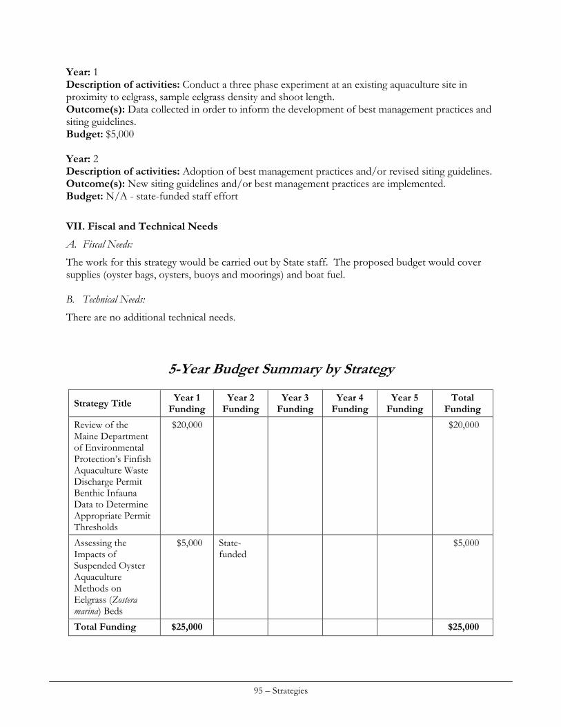
Year: 1 Description of activities: Conduct a three phase experiment at an existing aquaculture site in proximity to eelgrass, sample eelgrass density and shoot length. Outcome(s): Data collected in order to inform the development of best management practices and siting guidelines. Budget: $5,000 Year: 2 Description of activities: Adoption of best management practices and/or revised siting guidelines. Outcome(s): New siting guidelines and/or best management practices are implemented. Budget: N/A - state-funded staff effort
VII. Fiscal and Technical Needs
A. Fiscal Needs:
The work for this strategy would be carried out by State staff. The proposed budget would cover supplies (oyster bags, oysters, buoys and moorings) and boat fuel. B. Technical Needs:
There are no additional technical needs.
5-Year Budget Summary by Strategy
Year 1 Funding
Year 2 Funding
Year 3 Funding
Year 4 Funding
Year 5 Funding
Total Funding Strategy Title
$20,000 $20,000 Review of the Maine Department of Environmental Protection’s Finfish Aquaculture Waste Discharge Permit Benthic Infauna Data to Determine Appropriate Permit Thresholds
$5,000 State-funded
$5,000 Assessing the Impacts of Suspended Oyster Aquaculture Methods on Eelgrass (Zostera marina) Beds
Total Funding $25,000 $25,000
95 – Strategies
COASTAL HAZARDS
Introduction
The coastal hazards strategies contained in this chapter propose important new data collection and mapping efforts and potential regulatory changes towards the goal of improving the protection of critical resources of state significance, reducing risk to private property and assisting communities in addressing climate variability. The regulated community along Maine’s shoreline, especially in coastal sand dune regions, represents a critical constituency who has been highly involved in planning and regulatory reform efforts over the years. Other constituencies including recreationalists, wildlife interests and others have also been key stakeholders in these efforts. These constituencies may want to pursue additional reforms to existing regulations in addition to those contained in this chapter. These ideas need to emerge as a complement to the strategies contained in this chapter. Mapping efforts in particular are of keen interest to affected stakeholders and governmental mapping efforts are often improved when credible local knowledge is taken into consideration. Additionally, some topic areas, such as climate variability and the level of threat proposed by accelerated sea level rise are still controversial and represent an area of disagreement with some constituents. State staff benefit from collaborative relationship with stakeholders interested in Maine’s beaches and shorelines that have been developed over the years via official task forces and informal communication. The Maine Coastal Program recognizes the importance of early and continuous outreach to interested parties and the role that stakeholders play in providing key knowledge about local conditions. We intend to work with stakeholders as the strategies contained in this chapter are undertaken. The success of the efforts described in this section will ultimately depend on proactive and continuous citizen involvement. Strategy #1. Coastal Resiliency at the Local Level: continue to pursue coastal resiliency with partner communities, support SLAWG steering committee and group efforts in Saco Bay, and work to expand resiliency efforts to include other communities and planning locations.
I. Issue Area(s)
The proposed strategy or implementation activities will support the following priority (high or medium enhancement area(s) (check all that apply):
Aquaculture Cumulative and Secondary Impacts Energy & Government Facility Siting Wetlands Coastal Hazards Marine Debris Ocean/Great Lakes Resources Public Access Special Area Management Planning
96 – Strategies
II. Program Change Description
A. The proposed strategy will result in, or implement, the following type(s) of program changes (check all that apply):
A change to coastal zone boundaries; New or revised authorities, including statutes, regulations, enforceable policies,
administrative decisions, executive orders, and memoranda of agreement/understanding; New or revised local coastal programs and implementing ordinances; New or revised coastal land acquisition, management, and restoration programs; New or revised Special Area Management Plans (SAMP) or plans for Areas of Particular
Concern (APC) including enforceable policies and other necessary implementation mechanisms or criteria and procedures for designating and managing APCs; and
New or revised guidelines, procedures and policy documents which are formally adopted by a state or territory and provide specific interpretations of enforceable CZM program policies to applicants, local government and other agencies that will result in meaningful improvements in coastal resource management.
B. Program Changes(s) or Implementation Activities
Building on the efforts and lessons learned of previously funded Section 309 work by the Maine Geological Survey (MGS) and the Southern Maine Regional Planning Commission (SMRPC), this strategy proposes to increase partnerships with local communities and working groups, and expand the coastal resiliency project efforts to other areas of the southern Maine coastline. Between 2007 and 2010, MGS and SMRPC have worked with the communities of Scarborough, Old Orchard Beach, Saco, Biddeford to introduce the concept of coastal resiliency and regional adaptation. This project built on numerous other MGS 309 funding projects, including the Maine Beach Mapping Program (MBMAP), Maine Beach Scoring System, and simulation efforts to illustrate the impacts of sea level rise on the future coastal floodplain, coastal wetlands, and shoreline erosion. Education and outreach workshops were held in each community to illustrate the types of datasets compiled by MGS on coastal hazards and potential impacts of sea level rise, and how that data could be utilized by the communities to develop local and regional adaptation strategies dealing with the potential impacts of sea level rise to the built and natural environments. Sea level rise and coastal hazard impacts are mostly felt at the local and regional levels, and it is at these levels that forward-looking ordinances, adaptation and management programs, and capital improvement efforts must be undertaken. The project has evolved to working closely with partner communities to identify existing and potential future problems, and identify workable local and regional adaptation strategies that require inter-community coordination and planning efforts. These strategies include: identification of low-lying uplands that will likely convert to wetlands due to sea level rise; identification of at-risk private and public infrastructure; development of forward-thinking local ordinances dealing with coastal floodplains and coastal wetlands; and development of regional approaches to dealing with and funding adaptation solutions. In 2009-2010, the project was expanded to include the Towns of Kennebunk and York in York County. In 2010, the project underwent a significant expansion in the formation of a Sea Level
97 – Strategies
Adaptation Working Group (SLAWG) steering committee in the Saco Bay area. Each partner community committed funding (both cash and in-kind) and designated 2 individuals to partake in the steering committee. The steering committee has been tasked with developing an organizational structure and a regional work plan for SLAWG that includes a variety of issues relating to sea level rise, including but not limited to:
Commenting on federal or state beach nourishment/erosion control efforts that affect more than one community, including management or deposition of dredged materials.
Identifying infrastructure vulnerable to storms and sea level rise such as culverts, storm drains, bridges or tide gates; using regional approaches to plan for improvements; and obtaining grants or appropriations for construction projects on a regional basis, or supporting individual municipal grant or appropriation requests for such projects.
Recommending the standardizing of floodplain management standards and building code interpretations across jurisdictions to improve resiliency of individual private structures.
Recommending standardizing of ordinance review standards affecting the shoreland adjacent to Saco Bay, as well as standardizing review and controls for water activities across jurisdictions, for structures and activities affected by sea level rise or coastal storms. Such water activities may or may not include land-based development, and could include aquaculture, marina, or green energy production projects.
Providing non-binding comments on various applications for development review affecting Saco Bay that may be vulnerable to sea level rise or coastal storms, to those individual review authorities having jurisdiction.
SLAWG’s steering committee planning efforts started in June 2010 and will continue through December, 2010. At the end of this time, formal acceptance of SLAWG and agreements with local town and city councils will be received for official SLAWG working group formation. The proposed strategy will support resiliency efforts in partner communities, including providing significant technical and regulatory support to SLAWG, as needed, and propose to expand resiliency efforts in the Greater Portland area, including Cape Elizabeth, South Portland, and Portland, and implement adaptation techniques in partner communities. This strategy will also work to involve economic analyses on the impacts of coastal hazards and sea level rise, including potential adaptation responses. This will require partnership with the New England Environmental Finance Center (NEEFC), that has worked to develop a tool called COAST, which has been piloted in Old Orchard Beach, Maine, and is currently undergoing revision and further testing in Groton, Connecticut as part of a climate change workshop approach to dealing with coastal resiliency. Bringing this approach into SLAWG’s efforts and regional efforts in Saco Bay will allow for a community-based understanding of the costs associated with sea level rise and different adaptation techniques, which are vital to overall local decision-making efforts. This strategy is consistent with the recommendations of the recently released report from a legislatively-appointed working group dealing with climate change in Maine. The report, entitled People and Nature Adapting to a Changing Climate: Charting Maine’s Course, provided specific recommendations to the Maine Legislature on climate change adaptation in including:
98 – Strategies
III. Need(s) and Gap(s) Addressed
This strategy addresses the need that local and regional strategies for adaptation to sea level rise are required in order to be most effective in Maine, a “home rule” state. Partnerships between local communities, SMRPC, and MGS bring together a local, regional, and state approach to developing coastal resiliency. This methodology, although tedious due to local disagreements, represents a holistic, regional, approach that has not been undertaken before. The agreements and regional approach of the project, including the SLAWG formation, provides a transferable model that can be used in other geographic regions within the State of Maine for furthering local and regional community coastal resiliency. An identified need and gap is the existence of local ordinances, such as those associated with the Mandatory Shoreland Zoning Act, that specifically relate to the potential impacts of sea level rise on both the built and natural environments on a regional basis, including economic impacts and adaptation strategy costs. This need will be addressed through the expansion of coastal resiliency efforts. The proposed strategy is to: expand the resiliency project to include other areas to other areas where local communities will work together to address coastal hazards and sea level rise on a regional level. The area proposed to be focused on as part of this strategy involves island communities of Casco Bay and the urban setting of the Greater Portland area.
IV. Benefit(s) to Coastal Management
Past resiliency efforts undertaken by MGS and SMRPC in Saco Bay have resulted in a coordinated, regional effort in the formation of the SLAWG steering committee in FY2010. Once the steering committee finalizes an organizational structure, work plan, and receives acceptance from the partner communities, SLAWG regional planning efforts will be commenced. These efforts will require technical support vital to local and regional coastal management efforts. The development of forward-looking, regionally based ordinances that are agreed upon by communities sharing geopolitical boundaries (and thus hazards and resources), as proposed by the project and SLAWG, significantly strengthen local and regional coastal management efforts. At the same time, this project has provided a baseline, transferable model for other locations that share regional resources and hazards. Expansion of these efforts into other regions would highly benefit coastal management efforts in Maine through a tested, integrated, and regional approach to education, outreach, and partner development in dealing with coastal resiliency. Continued and expanded resiliency efforts would result in local and regional programmatic coastal management changes relating to local ordinances, and coordinated regional strategies and adaptation efforts for dealing with sea level rise impacts to natural and built environments.
V. Likelihood of Success
Although the current efforts in Saco Bay have taken 3 years to bring to fruition culminating in the formation of SLAWG in FY2010, the lessons learned from the project to-date are quite transferable for continued and expansion of coastal resiliency efforts. It is clear that the project team has learned to gain initial perspectives on sea level rise impacts and develop clear goals with partner
99 – Strategies
communities early in the project planning process. This can be achieved by conducting social science keypad polling, which was done successfully with Kennebunk and York, in order to better understand and bridge the differences between communities. Because of the experience of MGS and SMRPC in previous efforts, the likelihood of success is considered to be moderate to high. Expansion of efforts will pull in not only other communities sharing regional boundaries, resources and hazards, but other regional planning organizations such as the Greater Portland Council of Governments (GPCOG), the Wells National Estuarine Research Reserve, other State agencies, and potential non-profit environmental organizations such as The Nature Conservancy and Casco Bay Estuary Partnership to help facilitate the development of regional approaches to dealing with sea level rise issues.
VI. Strategy Work Plan
Total Years: 5 Total Budget: $186,900 Final Outcome(s) and Products: Adoption of coastal resiliency practices in partner communities. Year(s): FY2011 Description of activities: Support resiliency efforts with partner communities of Scarborough, Old Orchard Beach, Saco and Biddeford, including supporting SLAWG efforts to implement the work plan developed by the SLAWG steering committee in FY2010. Support Kennebunk and York to continue ongoing efforts at local resiliency. Expand resiliency efforts in the Greater Portland area based on initial outreach completed in 2010. Create new resiliency efforts with additional project partners and begin implementation of adaptation techniques. Work to introduce the concept of regional resiliency approaches to new potential project partners. Hold planning meeting with NEEFC to determine approach for incorporation of COAST into SLAWG and Saco Bay regional planning efforts. Outcome(s): Support efforts with existing communities. Establish of a partnership with other coordinating agencies and groups for project expansion. Provide baseline information to new partner communities. Commence planning efforts with NEEFC on COAST tool integration. Budget: $35,200 Year(s): FY2012 Description of activities: Continue implementation of the SLAWG working plan on a regional basis in Saco Bay. Report on SLAWG to other partner communities. Continue extensive coordination relating to ordinance development and identification of regional strategies in new partner communities. Begin implementation of strategies, as applicable. Outcome(s): Implementation of SLAWG working plan. Ordinance development and identification of regional strategies in partner communities. Partnership with NEEFC for beginning of implementation of COAST in Saco Bay communities. Budget: $35,900
100 – Strategies
Year(s): FY2013-2015 Description of activities: Full implementation of ordinances, strategies, and adaptation techniques in all partner communities. Generation of a white paper outlining all efforts undertaken and the results for transferability to communities in Maine and New England. Outcome(s): Implementation of strategies and development of paper model for transferability of resiliency process. Completion of COAST economic analyses for adaptation strategies costs. Budget: FY2013: $37,400 FY2014: $38,600 FY2015: $39,800
VII. Fiscal and Technical Needs
A. Fiscal Needs:
Local and regional matching funds (in-cash and in-kind) will be clearly needed, and will be sought from partner communities at the start of the planning process. B. Technical Needs:
MGS, SPO, SMRPC, and GPCOG have the technical capabilities to bring the continued efforts, and expanded efforts, to fruition. Additional coordination will likely be required with partner communities, the NEEFC, and other organizations such as the Casco Bay Estuary Partnership, the Nature Conservancy, and potentially other regional and State partners as project expansion continues. Strategy #2. Coastal Hazard Data Collection and Mapping: Efforts to support various regulatory programs at the local to State levels.
I. Issue Area(s)
The proposed strategy or implementation activities will support the following priority (high or medium enhancement area(s) (check all that apply):
Aquaculture Cumulative and Secondary Impacts Energy & Government Facility Siting Wetlands Coastal Hazards Marine Debris Ocean/Great Lakes Resources Public Access Special Area Management Planning
II. Program Change Description
A. The proposed strategy will result in, or implement, the following type(s) of program changes (check all that apply):
A change to coastal zone boundaries; New or revised authorities, including statutes, regulations, enforceable policies,
administrative decisions, executive orders, and memoranda of agreement/understanding; New or revised local coastal programs and implementing ordinances; New or revised coastal land acquisition, management, and restoration programs;
101 – Strategies
New or revised Special Area Management Plans (SAMP) or plans for Areas of Particular Concern (APC) including enforceable policies and other necessary implementation mechanisms or criteria and procedures for designating and managing APCs; and
New or revised guidelines, procedures and policy documents which are formally adopted by a state or territory and provide specific interpretations of enforceable CZM program policies to applicants, local government and other agencies that will result in meaningful improvements in coastal resource management.
B. Program Changes(s) or Implementation Activities
Delineation of the upper limits of the regulatory coastal wetland in support of Maine’s Shoreland Zoning Program using LIDAR data;
Monitoring shoreline changes on an annual basis using the Maine Beach Mapping Program (MBMAP) in support of the Coastal Sand Dune Rules;
Analyzing collected data using GIS and updating regulatory boundaries of the Coastal Sand Dune Rules on a regular interval;
Revise and add new Google Earth KML data layers from collected coastal hazards data to support local, regional, and State-level regulations and decision-making.
Delineation of Wetland Boundary in Support of the Shoreland Zoning Program
Maine’s Mandatory Shoreland Zoning Act requires all municipalities to adopt, administer, and enforce ordinances which regulate land use activities within 250 feet of great ponds, rivers, freshwater and coastal wetlands, including all tidal waters; and within 75 feet of streams as defined. In coastal areas, the 250 foot buffer included in Shoreland Zoning ordinances is determined based on a distance from the upper, landward limits of the coastal wetland. NRPA defines a coastal wetland as areas subject to tidal action during the highest tide level for each year in which an activity is proposed as identified in tide tables published by the National Ocean Service. However, most coastal communities have developed and adopted Shoreland Zoning Maps that inadequately portray the boundaries of the shoreland zone. Many of these maps use outdated and inaccurate data to show the highest tide level since they use the shoreline extracted from 1:24,000 scale USGS 7.5’ topographic quadrangle maps, many of which were created in the 1970s. Accurate delineation of this boundary is required to create accurate resource management ordinances associated with the Mandatory Shoreland Zoning Act for Maine’s coastal communities. This effort will revise a pilot template for using high-resolution LIDAR data in a geographic information system (GIS) to more accurately define the limits of the highest annual tide that was completed with 309 funds in FY2010. Subsequent efforts will work toward external verification and DEP adoption of approved methods to support the regulatory definition. Lastly, MGS will create new, revised and much more accurate shoreland zoning boundaries for communities to use in municipal maps required by the Mandatory Shoreland Zoning Act. This effort is consistent with the recommendations of the report People and Nature Adapting to a Changing Climate: Charting Maine’s Course prepared by a legislatively-appointed stakeholder group in 2010.
102 – Strategies
Maine Beach Mapping Program (MBMAP)
MGS data has helps support regulatory decision-making at the State level by Maine DEP, supports science by MGS, and helps local communities better understand the impacts of coastal hazards. Data collected is typically analyzed and released biannually to the public as part of the State of Maine’s Beaches conference. This data also supplements the data collected by the State of Maine Beach Profiling Project (SMBPP), which uses trained volunteers to collect monthly beach profiles at select locations. However, the SMBPP data is not of an accuracy that supports regulatory decision-making, while MBMAP data is highly accurate (on the order of several centimeters). This specific effort would focus on collection of alongshore beach characteristic data that is needed to understand the impacts of storm events, short-and-long term erosion, along southern Maine’s beaches, in support of Maine’s Coastal Sand Dune Rules. Additionally, this portion of the strategy is consistent with the recommendation from the 2010 Climate Change Adaptation Plan Stakeholder Group report, titled People and Nature Adapting to a Changing Climate: Charting Maine’s Course, which specifically states:
Recommendation A.2.1.1 Identify existing monitoring systems relevant to climate change adaptation and policy initiatives; determine the accessibility of their climate change related data; identify monitoring systems that could fill voids in critical information and implementation strategies; and improve the integration of monitoring data in support of climate change decision making. Those ecosystems most vulnerable to climate change impacts, such as….coastal salt marshes and beaches …
Analyzing collected data and updating regulatory boundaries on a regular interval
MGS’s data is integral to maintaining up-to-date regulatory boundaries as part of the Coastal Sand Dune Rules (Chapter 355, NRPA). The Maine Beach Mapping Program (MBMAP), in conjunction with other efforts such as LIDAR data collection and aerial photography, regulatory boundaries can and need to be updated as conditions change. MGS will use collected data to re-analyze existing regulatory boundaries associated with the coastal sand dune system at an interval of approximately every 5 years in order to ensure that the most up-to-date information is used to support the location of regulatory boundaries in the coastal sand dunes. This effort is consistent with recommendation from the report People and Nature Adapting to a Changing Climate: Charting Maine’s Course:
Recommendation B.4.3.2 The Maine Geological Survey should periodically evaluate the adequacy of current setback requirements for beaches and bluffs, and recommend updates to existing policies.
Revise and develop new Google Earth KML data layers from collected coastal hazards data to support local, regional, and State-level regulations and decision-making
MGS generates a variety of GIS data relating to mapping and characterization of coastal hazards along the southern Maine coastline. Much of this information has not been released to the public
103 – Strategies
aside from inclusion in the biennial State of Maine’s Beaches conference and reports in 2007 and 2009. This effort would focus on revising and creating new Google Earth KML data by creating new or maintaining updated, readily downloadable and easily useable Google Earth data layers from the different GIS data layers that have been generated by MGS. The effort would continue the release of layers to the general public through the MGS website similar to what was done for Maine’s Mineral Resources.
III. Need(s) and Gap(s) Addressed
Delineation of Wetland Boundary in Support of the Shoreland Zoning Program
Accurately delineating the upland limits of the highest tide level for each year (highest annual tide, HAT) using NOS tide table data is an existing requirement for Maine’s Mandatory Shoreland Zoning Act. Although tide tables are published each year by MGS, communities have adopted Shoreland Zoning Maps based on shoreland zone setbacks that use old and outdated shorelines to represent the HAT. Thus, communities are implementing shoreland zoning ordinances using an outdated and inaccurate baseline. Using recently acquired (or soon to be flown) LIDAR data to accurately define the limits of the HAT using tidal data within coastal communities addresses the priority need of ensuring the use of the best, most accurate, and most recently available data to support local and regional planning, decision-making, and regulation of natural resources under Maine’s Mandatory Shoreland Zoning Act. The need to utilize accurate, best available information to support these programs was listed in the current Assessment.
Maine Beach Mapping Program (MBMAP)
There is a need to collect data to help understand the response of Maine’s beaches to storm events, and to characterize short and long-term erosion of Maine’s beaches in order to support a multitude of regulatory and planning purposes. Data collection as part of MBMAP directly relates to Maine’s Coastal Sand Dune Rules (Chapter 355, NRPA), which specifically relate to understanding both short and long-term erosion rates along Maine’s beaches for defining setbacks such as the Erosion Hazard Area or projecting where the shoreline might be in the future. This effort addresses the vital need of providing up-to-date, highly accurate, beach change data to support state, regional, and local decision-making relating to coastal hazards and implementation of Maine’s Coastal Sand Dune Rules.
Analyzing collected data and updating regulatory boundaries on a regular interval
It is imperative that the most recent, most highly accurate data is used to support the location of regulatory boundaries. It is also imperative that regulatory boundaries be updated at a regular interval in order to reflect the most recent changes in the beach system taking into account coastal erosion and sea level rise changes.
104 – Strategies
To this end, MGS proposes to use the best and most accurate up-to-date information to update the regulatory boundaries of the Coastal Sand Dune System, including the locations of the mapped frontal dune (D1), back dune (D2), and Erosion Hazard Areas (EHAs) on an approximate 5-year interval. The last remapping was completed in 2006. This effort addresses the vital need of documenting highly accurate regulatory boundaries that reflect dynamic beach changes at a regular interval.
Revise and develop Google Earth KML data layers from collected coastal hazards data
Creating and maintaining up-to-date and easily distributable coastal hazard data layers for the general public increases the public’s accessibility to GIS data without needing extensive GIS software for viewing data. This effort addresses the continued vital need of providing the general public, along with local and regional managers with recent, important yet easily accessible data that supports local decision-making relating to coastal hazards.
IV. Benefit(s) to Coastal Management
Delineation of Wetland Boundary in Support of the Shoreland Zoning Program
The accurate delineation of HAT boundaries would provide Maine DEP and local communities with an updated, much more accurate baseline boundary with which to establish the required shoreland zoning setbacks as required under the Shoreland Zoning Act. This, in turn, will allow for much more accurate and better delineation of different shoreland zones for better resource protection and community planning and regulation efforts. From a coastal management standpoint, the delineation of an accurate HAT would have significant benefits to planning, resource protection, and additional regulatory efforts for many parties from the local to state level, including but not limited to:
local planning boards and communities; regional planning organizations; Maine Department of Environmental Protection (NRPA, Shoreland Zoning); Maine Department of Marine Resources; Maine State Planning Office (Coastal Program, Land Use Program).
Maine Beach Mapping Program (MBMAP)
This effort will aid the State in maintaining beach change data that is required to support parts of Maine’s coastal regulatory structure. Data collected by MBMAP will include:
Alongshore position of the high water mark (or wrack/debris line) Alongshore position of the seaward edge of dune vegetation Elevations of the beach and toe of dune
This data is vital to understanding beach response to storm events, to monitor changes in the beaches, in order to provide better coastal management for Maine’s beach systems. Supporting a
105 – Strategies
good beach monitoring program was identified by the Beach Stakeholder Group in its report to the Maine Legislature, Protecting Maine’s Beaches for the Future: A Proposal to Create an Integrated Beach Management Program, as vital to ensuring proper management of Maine’s beaches. The highly accurate data is collected by a summer intern using a Real Time Kinematic (RTK) GPS and has horizontal and vertical accuracies of several centimeters. This type of accuracy is required for decision-making in the coastal zone. In support of regulatory accuracy, data needs to be collected once per year at most beaches and several times a year at key locations. Data collected as part of MBMAP is used by the following coastal managers for local and regional planning, resource protection, and additional regulatory efforts, including but not limited to:
local planning boards and communities; regional planning organizations; private businesses and environmental consultants; non-profit environmental organizations; other Maine State agencies or federal agencies; the general public.
Collection of MBMAP data supports the following State efforts:
Chapter 355, Coastal Sand Dune Rules Defining the upper edge of the Coastal Wetland using Highest Annual Tide (NRPA and SZ) Monitoring marsh elevations in relation to mapped LIDAR elevations Beach habitat management for rare and endangered migratory birds Design of beach nourishment projects Guiding design of dune restoration projects
Analyzing collected data and updating regulatory boundaries on a regular interval
This effort will aid the State in ensuring that its regulatory boundaries in the Coastal Sand Dune System reflect recent, up-to-date data. Maintaining these regulatory boundaries in such a dynamic setting has significant implications to regional planning, resource protection, and additional regulatory efforts by coastal managers, including but not limited to:
Maine DEP implementation of the Coastal Sand Dune Rules (Chapter 355); local planning boards and communities; regional planning organizations; private businesses and environmental consultants; non-profit environmental organizations; the general public
Development of Google Earth KML data layers from collected coastal hazards data
This effort will continue the State’s distribution of collected coastal hazard data to local and regional managers, federal agencies, and the general public. A limitation has always been the complexity with
106 – Strategies
distributing and viewing GIS data for the general public, when the public does not have GIS viewing resources. This is no longer an issue with the advent of the Google Earth platform. Some of the data that could be released includes but is not limited to:
Coastal Bluff and Landslide Hazard layers (sheltered coast erosion) Coastal Marine Geologic Environment layers (intertidal habitats) Short- and long-term shoreline erosion rates and shoreline position data layers Shoreline characterization layers (dry beach width, seawalls, dune elevations) Beach scoring system data layers (dune restoration, beach nourishment needs) LIDAR data coverage Potential impacts of sea level rise data layers (inundation maps)
From a coastal management standpoint, making data compatible with Google Earth for general use will have significant benefits to local and regional planning, resource protection, and additional regulatory efforts, including but not limited to:
local planning boards and communities; regional planning organizations; private businesses and environmental consultants; non-profit environmental organizations; other Maine State agencies or federal agencies; the general public.
Generation of these data layers would also feed into the Maine Coastal Atlas data portal, which is currently in preliminary phases of development with the Maine Coastal Program, MGS, and the Gulf of Maine Research Institute.
V. Likelihood of Success
Delineation of Wetland Boundary in Support of the Shoreland Zoning Program
The likelihood of success in creating a defined HAT boundary in Maine’s coastal communities to support Shoreland Zoning mapping efforts is high. New and much more accurate data is (or will be soon) available to aid in the process to support the efforts. LIDAR data (from 2004, 2006, and 2007) is available for the southern and portions of mid-coastal Maine and ongoing efforts to acquire data for the entire coastal zone by 2011 are underway. This topographic data is critical for accurately defining the HAT. A pilot effort to remap the upper boundary of the highest annual tide was undertaken in the community of Old Orchard Beach, ME (one of the partner communities working on coastal resiliency and a member of the SLAWG organizing committee) by the Southern Maine Regional Planning Commission. The community was impressed with the accuracy of the newly defined boundary in creating its required setbacks when compared with the inaccuracies of the old boundary derived from USGS 7.5’ topographic quadrangle shorelines.
107 – Strategies
Support for this strategy exists within the Maine DEP, and from individual coastal communities that want to accurately define their shoreland zones using the best available data at minimal expense. Support will be solicited early in the process through development of a survey to first gauge existing perceptions on the accuracy or inaccuracy of the defined boundaries, and potential requirements and uses of the revised maps as a result of the update. As the process evolves, local communities (partner SLAWG communities), regional Planning Commissions, and Maine DEP will be requested to partake in the updating process in terms of providing feedback on the pilot template in Year 1 (see Strategy Work Plan), and will be integral to the process in subsequent years.
Maine Beach Mapping Program (MBMAP)
The likelihood of success in continuing MBMAP is moderate. Since the Marine Geology Division at MGS only includes two geologists, it is difficult to complete the required beach monitoring without the help of a summer intern. Without the intern, it is likely that not all beaches in southern Maine could be successfully mapped each season. Substantial data gaps would likely result and adversely affect calculations of beach erosion rates and subsequent local, regional, and state decision-making and implementation of existing regulations in Maine.
Analyzing collected data and updating regulatory boundaries on a regular interval
The likelihood of success in providing an update to the Coastal Sand Dune System’s regulatory boundaries is moderate. The last update was undertaken in 2006 as part of substantive rule-making associated with the Beach Stakeholder Group’s efforts at revising the Coastal Sand Dune Rules (Chapter 355). It is likely that remapping efforts in terms of updating the dune boundaries may require additional rule-making if the changes are deemed to be substantive.
Develop Google Earth KML data layers from collected coastal hazards data
The likelihood of success in generating new or updated Google Earth data layers for MGS GIS coastal hazards data is high. ArcGIS software has made the conversion of such layers an easier process, and MGS has the in-house capabilities to perform such work.
VI. Strategy Work Plan
Total Years: 5 Total Budget: $265,500 Final Outcome(s) and Products: The final outcomes of this strategy will be multiple efforts and data that can be used to support Maine’s existing regulatory programs and decision making, from the local to state levels. These outcomes and products will include:
Updated, highly accurate Highest Annual Tide GIS map layer that can be used by coastal communities to create revised, more accurate Shoreland Zoning maps in support of the Mandatory Shoreland Zoning Act.
Documentation of beach changes as part of MBMAP, with dedicated funds to support a yearly summer intern and associated field and travel expenses. New GIS data layers of shorelines for erosion rate calculations and recreational beach width for beach management and use in biannual State of Maine’s Beaches reports.
108 – Strategies
Updated regulatory boundaries for support of the Coastal Sand Dune Rules (Chapter 355) at approximately a 5 year interval.
Distribution of Google Earth compatible data layers of coastal hazard GIS information compiled by MGS over the past decade.
Delineation of Wetland Boundary in Support of the Shoreland Zoning Program
Year: FY2011 Description of activities: Year 1 of the project will further refine a “pilot” effort. The HAT template will be edited and reviewed, as needed. Pilot work will include:
solicit review from the pilot community Shoreland Zoning map users from the communities of Biddeford, Saco, Old Orchard Beach, and Scarborough (partner SLAWG communities), the Southern Maine Regional Planning Commission, and Maine DEP Shoreland Zoning Program for feedback on the boundary creation process;
refine the GIS template that was developed in order to update the Shoreland Zoning HAT boundary and subsequent 250 foot buffers.
directly engage partner SLAWG communities, regional planning organizations, and State agencies;
determine potential criteria and methodology for mandatory remapping of Shoreland Zones in the future;
Outcome: a refined “draft” Shoreland Zoning HAT boundary and Shoreland Zone buffer template for SLAWG communities, based on input from solicited users. Budget: $18,100 Year: FY2012-2015 Description of activities: Updating of Shoreland Zoning base map (HAT and 250 foot buffer) layers based on the map template created and refined with significant end-user input. This will entail receipt of new LIDAR data for the remainder of the Maine coastline by 2013. Creation of the final end-product maps in digital format, online downloadable format, etc. for distribution to the general public and use by a variety of end-point users from the local to regional and state levels. Outcome: finalized revised, updated Shoreland Zoning base map layers (HAT and 250 foot buffer) for use by local communities to create updated Shoreland Zoning Maps. Budget: FY2012: $12,600 FY2013: $13100 FY2014: $26,900 FY2015: $27,900
Maine Beach Mapping Program (MBMAP)
Year: FY2011-2015 Description of activities: MGS will implement the MBMAP project with a dedicated summer intern and dedicated travel funds to support mapping efforts. Outcome: Collection of MBMAP beach data and conversion of collected data into GIS format for ease of analysis and use in beach management plans, regulatory programs, and municipal resiliency efforts. Budget: FY2011: $26,400
109 – Strategies
FY2012: $25,900 FY2013: $26,900 FY2014: $27,800 FY2015: $28,700
Analyzing collected data and updating regulatory boundaries on a regular interval
Year: FY2012-2013 Description of activities: MGS will update the locations of the regulatory boundaries of the Coastal Sand Dune Rules, notably the location of the frontal dune, back dune, and the Erosion Hazard Area, based on the most recently available information. This information will include most recently collected LIDAR topographic data and aerial photography, analysis of short and long-term erosion trends, and changes in sea level rise rates. Outcome: Updated regulatory boundaries for the Coastal Sand Dune Rules at an approximate 5 year interval. Budget: FY2012: $12,600 FY2013: $13,100
Development of Google Earth KML data layers from collected coastal hazards data
Year: FY2011 Description of activities: Creation of new data layers, as needed and updating of layers as required. Uploading of data layers so that they can easily be distributed to the public through the MGS website. Outcome: Google Earth data layers of MGS collected coastal hazard information. Budget: $5,500
VII. Fiscal and Technical Needs
A. Fiscal Needs:
Delineation of Wetland Boundary in Support of the Shoreland Zoning Program
After the development of a DEP Shoreland Zoning-approved mapping process, MGS will be in a position to assist the state and municipalities in their development of maps potentially through revenue sharing and interagency agreements.
Maine Beach Mapping Program (MBMAP)
309 funding is sufficient to carry out this strategy with oversight by MGS staff.
110 – Strategies
Analyzing collected data and updating regulatory boundaries on a regular interval
MGS will provide in-kind staff support from the General Fund to assist with this effort through geological analysis, field work, and peer review. DEP will provide financial support for rulemaking to adopt the revised regulatory boundaries.
Development of Google Earth KML data layers from collected coastal hazards data
MGS will provide in-kind support and services for web site management and distribution of digital data layers through its web site or the Maine Office of GIS. B. Technical Needs:
The Maine Geological Survey has the technical knowledge, skills, and equipment to complete the efforts associated with this overall strategy. Additional technical support needs are as noted, below.
Delineation of Wetland Boundary in Support of the Shoreland Zoning Program
This effort will require support and coordination with Maine DEP (Shoreland Zoning) and local communities. MGS is also capable of generating versions of the Highest Annual Tide map for use in Google Earth format that either MGS or DEP can then provide via state web pages.
Analyzing collected data and updating regulatory boundaries on a regular interval
This effort will require significant support from and coordination with the Maine DEP in terms of review and substantive rulemaking, as required. Strategy #3. Revising and Creating Coastal Hazard and Climate Change Regulation and Statutory Language
I. Issue Area(s)
The proposed strategy or implementation activities will support the following priority (high or medium enhancement area(s) (check all that apply):
Aquaculture Cumulative and Secondary Impacts Energy & Government Facility Siting Wetlands Coastal Hazards Marine Debris Ocean/Great Lakes Resources Public Access Special Area Management Planning
111 – Strategies
II. Program Change Description
A. The proposed strategy will result in, or implement, the following type(s) of program changes (check all that apply):
A change to coastal zone boundaries; New or revised authorities, including statutes, regulations, enforceable policies,
administrative decisions, executive orders, and memoranda of agreement/understanding; New or revised local coastal programs and implementing ordinances; New or revised coastal land acquisition, management, and restoration programs; New or revised Special Area Management Plans (SAMP) or plans for Areas of Particular
Concern (APC) including enforceable policies and other necessary implementation mechanisms or criteria and procedures for designating and managing APCs; and
New or revised guidelines, procedures and policy documents which are formally adopted by a state or territory and provide specific interpretations of enforceable CZM program policies to applicants, local government and other agencies that will result in meaningful improvements in coastal resource management.
B. Program Changes(s) or Implementation Activities
This strategy is to address documented deficiencies with existing Maine regulation and policy. The strategy is broken into two regulatory efforts, including:
Revise an existing regulatory definition of an Erosion Hazard Area in the Coastal Sand Dune Rules, and
Creation of a new statutory definition in NRPA for a Future Coastal Wetland.
Revise the definition of an Erosion Hazard Area in the Coastal Sand Dune Rules
As part of Maine’s Coastal Sand Dune Rules (Chapter 355, NRPA), an Erosion Hazard Area (EHA) is currently defined as
Any portion of the coastal sand dune system that can reasonably be expected to become part of a coastal wetland in the next 100 years due to cumulative and collective changes in the shoreline from:
1) Historical long-term erosion;
2) Short-term erosion resulting from a 100-year storm; or
3) Flooding in a 100-year storm after a two-foot rise in sea level,
or any portion of the coastal sand dune system that is mapped as an AO flood zone by the effective FEMA Flood Insurance Rate Map, which is presumed to be located in an Erosion Hazard Area unless the applicant demonstrates based upon site-specific information, as determined by the department, that a coastal wetland will not result from either (1), (2), or (3) occurring on an applicant's lot given the expectation that an AO-Zone, particularly if located immediately behind a frontal dune, is likely to become a V-Zone after 2 feet of sea level rise in 100 years.
Maine recognizes that sea level is rising. A 2-year stakeholder process from 2004-2006 involving Maine state agencies, consultants and property owner’s groups, resulted in agreement on, and substantial revision of the Maine Coastal Sand Dune Rules (Chapter 355), including the definition
112 – Strategies
for an EHA, as stated above. This same stakeholder group also created the Protecting Maine’s Beaches for the Future: A Proposal to Create an Integrated Beach Management Program report. During implementation of this definition since 2006, Maine DEP and MGS identified that specific wording of the definition was not meeting its original regulatory intent to pinpoint only those areas of the back dunes (D2 according to the Beach and Dune Geology Aerial Photos) which might be eroded or undergo coastal flooding due to either a large storm in the future when taking into account sea level rise, or slower, long-term erosion when taking into account sea level rise. Instead, the definition was also capturing areas of the back dune that would become a portion of a coastal wetland simply due to static flooding. Thus, a revised definition of the Erosion Hazard Area in the Coastal Sand Dune Rules is required to meet its original regulatory intent. This definition will supplement the creation of a definition of a Future Coastal Wetland that takes into account sea level rise (also in this Strategy).
Develop a statutory definition for a Future Coastal Wetland for inclusion in the Natural Resources Protection Act
Maine’s Natural Resources Protection Act (NRPA) defines a coastal wetland as all tidal and subtidal lands; all areas with vegetation present that is tolerant of salt water and occurs primarily in a salt water or estuarine habitat; and any swamp, marsh, bog, beach, flat or other contiguous lowland that is subject to tidal action during the highest tide level for the year in which an activity is proposed as identified in tide tables published by the National Ocean Service (Title 38, §480-B) As part of Maine’s Coastal Sand Dune Rules (Chapter 355, NRPA), Maine recognizes that sea level is rising, and coastal projects located in the sand dune system should plan for an projected 2 feet of sea level rise over the next 100 years. It is clear that sea level will also be impacting Maine’s natural resources, including coastal wetlands. Maine’s existing definition of coastal wetlands relates to a tidal elevation (the highest tide level, or highest annual tide). In support of this, each year MGS creates a table describing the highest tide level for each year using NOS data for locations along the Maine coastline. However, the statutory definition does not take into account any impacts of sea level rise in its regulatory context, even though 2 feet of sea level rise over the next 100 years is specifically referenced in the Coastal Sand Dune Rules. A new, expanded, or revised statutory definition of a Future Coastal Wetland that takes into account sea level rise is required. This effort will focus on developing a draft State regulatory definition for a Future Coastal Wetland and the methodology that should be used to delineate and support the definition, based on the results of work efforts to develop a pilot definition for inclusion by partner SLAWG communities into local ordinances. This has significant regulatory and resource protection recourse in the NRPA, and will require substantive legislation followed by rulemaking. The efforts associated with this strategy is consistent with recommended strategies from the report People and Nature Adapting to a Changing Climate: Charting Maine’s Course, prepared by a Legislatively appointed stakeholder group in 2010, including:
113 – Strategies
Strategy B.4.3 Coastal Adaptation: Establish a Continuing State-Level Effort to Develop Policy, Prepare for, and Create Resilience to, the Most Likely Foreseeable Impacts of Climate Change on the Maine Coast
III. Need(s) and Gap(s) Addressed
Revise the definition of an Erosion Hazard Area in the Coastal Sand Dune Rules
Maine’s 2010 Assessment identified that the definition of an Erosion Hazard Area as part of the existing Coastal Sand Dune Rules does not meet its regulatory intent. The original intent of the EHA definition was to pinpoint unstable areas outside of the frontal dune (i.e., areas of the mapped “back dune”, designated as D2 areas on the Beach and Dune Geology Aerial Photos) which might be eroded or undergo coastal flooding due to either a large storm in the future when taking into account sea level rise, or slower, long-term erosion when taking into account sea level rise. In support of the new definition, MGS and DEP worked to remap the existing boundaries of the coastal sand dune system using newer (2003) aerial photographs and 2004 topographic LIDAR data (the original aerials used 1986 stereo-photographs only). As part of this, MGS also established the boundary for the EHA. However, it was discovered that the definition, as worded did not meet its regulatory intent in identifying only those areas of the back dune that may be subject to coastal erosion or dynamic flooding. Instead, the definition was including low-lying areas adjacent to back-barrier marshes that would become part of a coastal wetland after 2 feet of sea level rise – these areas are clearly not Erosion Hazard Areas based on the regulatory intent of the definition. A revised definition of an Erosion Hazard area is thus clearly needed in order to support the regulatory intent of the original definition, and to support the mapping efforts to delineate EHAs in Maine’s Coastal Sand Dune System.
Develop a statutory definition for a Future Coastal Wetland for inclusion in the Natural Resources Protection Act
Parts of Maine’s 2010 Assessment identified that its regulations need to more strongly prepare the built and natural environments for the potential impacts of sea level rise. Maine’s existing Coastal Sand Dune Rules do take into account 2 feet of sea level rise over the next 100 years for planning development in the sand dune system; however, no regulatory language is in-place currently to address the potential impacts of sea level rise on existing natural environments, such as the coastal wetland, which already has an existing, flexible definition relating to tidal elevations. An expanded, more flexible regulatory definition (and support methodology for defining these areas) is needed to identify, regulate, and conserve areas that will likely become coastal wetlands in the future in response to sea level rise. These areas are typically low-lying uplands, both developed and undeveloped, or freshwater wetlands. Identification of these areas is vital to a long-term approach for resource management and allowing coastal wetlands to transgress naturally in response to sea level rise.
114 – Strategies
IV. Benefit(s) to Coastal Management
This overall strategy will aid the State in its efforts to protect and conserve its vital natural resources in coastal sand dunes and coastal wetlands, will clarify regulatory intent of existing rules, and help local communities and planning organizations take into account the influence of sea level rise on the natural as well as the built environments. This strategy will aid the State in successful implementation of its Natural Resources Protection Act, which guides development in the Coastal Sand Dune System and other areas in order to protect and conserve vital natural resources. From a coastal management standpoint, revising the definition of the Erosion Hazard Area and supplementing it with the creation of a defined Future Coastal Wetland that takes into account sea level rise will clarify the regulatory intent and have significant benefits to planning, resource protection, and additional regulatory efforts relating to sea level rise for many parties from the local to state level, including but not limited to:
local planning boards and communities; regional planning organizations; non-profit environmental organizations and land trusts; Maine Department of Environmental Protection (NRPA, Shoreland Zoning) Maine Department of Marine Resources Maine State Planning Office (Coastal Program, Land Use Program);
V. Likelihood of Success
The likelihood of success in revising the definition of an Erosion Hazard Area under the Coastal Sand Dune Rules and Maine NRPA is high. A strong partnership between the Coastal Program, MGS, and Maine DEP already exists. This proposed strategy would create the groundwork for substantive rule-making that is required by the Maine DEP in order to add to or revise a regulatory definition in the NRPA. MGS has already been working with Maine DEP to properly delineate the EHA for inclusion on maps, as per its regulatory intent using existing LIDAR data, sea level rise, and erosion rates. At the same time, Maine DEP has been interpreting the existing EHA definition based on its original regulatory intent. Therefore, mechanisms are already in place for implementation of changes to the wording of the rule. MGS and DEP will work to revise the definition of an EHA to meet its original intent, and undergo substantive rulemaking and approval by the Maine Legislative. The likelihood of success in creating a new or expanded definition of a Future Coastal Wetland under the Maine NRPA is moderate to high. A strong partnership between the Coastal Program, MGS, and Maine DEP already exists through previous efforts in supporting rule-making and stakeholder groups. This proposed strategy would create the groundwork for substantive legislative initiatives by DEP and subsequent rulemaking that is required to add to or revise Maine statutes that builds on the experiences with local communities on implementing such a definition. MGS works with existing LIDAR data to show partner SLAWG communities the potential for coastal wetland expansion in low-lying uplands. Newer, much more accurate data is (or will be
115 – Strategies
soon) available to aid in the process to support the efforts. LIDAR data (from 2004, 2006, and 2007) is available for the southern and portions of mid-coastal Maine and ongoing efforts to acquire data for the entire state by 2011 are underway. This topographic data would be critical for supporting the efforts to accurately map areas of coastal Maine that might become part of a future coastal wetland. MGS plans to bring the concept of a future coastal wetland to partner SLAWG communities (Old Orchard Beach, Scarborough, Biddeford, and Saco) in FY2010 in an effort to work to develop the pilot definition on a local level for inclusion in local ordinances, for further enhancement into a state NRPA regulatory definition. Support for this strategy already exists within the MGS, the Coastal Program and Maine DEP. As the process evolves, local communities (partner SLAWG communities), regional Planning Commissions, and Maine DEP will be requested to partake in the process to fully develop the pilot definition for substantive rule-making and Legislative approval.
VI. Strategy Work Plan
Total Years: 5 Total Budget: $86,600 Final Outcome(s) and Products: The final outcomes of this strategy will be multiple and will include:
Revised definition for an Erosion Hazard Area to meet the original regulatory intent of the existing definition, to be incorporated into NRPA.
New statutory definition for a Future Coastal Wetland, with support methodology for delineation, to be incorporated into NRPA or other statutes related to climate change and adaptation.
Revised Definition of an Erosion Hazard Area
Year: FY2011-2012 Description of activities: Work with Maine DEP and Attorney General to develop a revised definition of an Erosion Hazard Area. Further refine the EHA definition and commence rulemaking with Maine DEP in Chapter 355. Timing may precede legislative efforts for the Future Coastal Wetland into Maine statutes. Outcome: Working definition, with support science and methodology, for and Erosion Hazard Area. Incorporation of the revised definition of EHA into the Coastal Sand Dune Rules, NRPA Chapter 355. Budget: FY2011: $8,200 FY2012: $10,000
New Statutory Definition for a Future Coastal Wetland
Year: FY2011 Description of activities: Year 1 of the project will work with Maine DEP and Southern Maine Regional Planning Commission to further develop the pilot definition for a Future Coastal Wetland that was created for partner SLAWG communities. Based on the pilot language created on the local level, the definition will be refined, as needed, into a working definition to be incorporated into the
116 – Strategies
Maine NRPA. The working definition will be used for subsequent rule-making efforts in Year 2. Pilot work will include:
Review of the pilot Future Coastal Wetland definition created with input from SLAWG communities;
solicit feedback on definition creation process; further develop the methodology and science to support the proposed changes or new
definition. Outcome: Working State definition, with support science and methodology, for a Future Coastal Wetland. Budget: $8,200 Year: FY2012-2014 Description of activities: Further refinement of the definition of a Future Coastal Wetland, as needed, and an initial draft of legislation to incorporate a new or revised definition into Maine statutes. Participation in interagency and stakeholder meetings to build consensus for the initiative. Outcome: Plans to introduce a bill to the Maine Legislature including a new policy for Future Coastal Wetlands Budget: FY2012: $6,700 FY2013: $17,300 FY2014: $17,800 Year: FY2015 Description of activities: Introduction of a bill in the Maine Legislature. Outcome: Passage of a new law through the legislature and signed by the governor. Revision of Maine’s Core Laws and programmatic approval by NOAA under the Coastal Zone Management Act. Budget: $18,400
VII. Fiscal and Technical Needs
A. Fiscal Needs:
MGS secured funds from DEP through an interagency agreement to map the EHA and to create GIS data for use in revised MGS maps used in regulation of the Coastal Sand Dune System. These products will be influential in showing the need to revise the EHA definition. Financial support for public rulemaking will be provided by DEP through this process. Supplemental state General Funds will be provided in-kind by state resource agencies to develop the Future Coastal Wetland policy, convene stakeholder meetings, and participate in the legislative process. This effort will most likely be part of climate change adaptation efforts underway by the resource agencies. B. Technical Needs:
The Maine Geological Survey has already delineated the boundaries of the EHA based on its original regulatory intent. Maine DEP has been interpreting the regulations based on the original intent. With the two combined capacities, the technical knowledge and skills to work on revising the EHA definition currently exist.
117 – Strategies
The Maine Geological Survey has the technical knowledge and skills to work on methodology and science behind defining a Future Coastal Wetland. MGS has been working with this concept with partner SLAWG communities for a year now. The strategy will require regulatory support and coordination with Maine DEP, local communities, Regional Planning Commission, and the Maine Coastal Program. Strategy #4. Expansion of Coastal Sand Dune boundary mapping to include the remainder of the Maine coastline in support of Chapter 355, Coastal Sand Dune Rules and CBRA.
I. Issue Area(s)
The proposed strategy or implementation activities will support the following priority (high or medium enhancement area(s) (check all that apply):
Aquaculture Cumulative and Secondary Impacts Energy & Government Facility Siting Wetlands Coastal Hazards Marine Debris Ocean/Great Lakes Resources Public Access Special Area Management Planning
II. Program Change Description
A. The proposed strategy will result in, or implement, the following type(s) of program changes (check all that apply):
A change to coastal zone boundaries; New or revised authorities, including statutes, regulations, enforceable policies,
administrative decisions, executive orders, and memoranda of agreement/understanding; New or revised local coastal programs and implementing ordinances; New or revised coastal land acquisition, management, and restoration programs; New or revised Special Area Management Plans (SAMP) or plans for Areas of Particular
Concern (APC) including enforceable policies and other necessary implementation mechanisms or criteria and procedures for designating and managing APCs; and
New or revised guidelines, procedures and policy documents which are formally adopted by a state or territory and provide specific interpretations of enforceable CZM program policies to applicants, local government and other agencies that will result in meaningful improvements in coastal resource management.
B. Program Changes(s) or Implementation Activities
The Maine Natural Resources Protection Act (NRPA: Title 38 M.R.S.A., Chapter 3, Section 480D, 2000) requires that new coastal development will not unreasonably (1) interfere with the natural supply or movement of sand within or to the sand dune system; (2) increase the erosion hazard to the sand dune system; (3) cause or increase the flooding of the dunes or adjacent properties; (4) interfere with the natural flow of any surface or subsurface waters; (5) inhibit the natural transfer of soil from the terrestrial to marine environments; (6) harm any significant wildlife habitat, threatened or endangered plant habitat, travel corridor, freshwater, estuarine or marine life; or (7) interfere with existing scenic, aesthetic, recreational, or navigational uses.
118 – Strategies
The Coastal Sand Dune Rules (Chapter 355) clarify the criteria for obtaining a permit under NRPA in regard to activities within Maine’s coastal sand dune systems. Maine is somewhat unique in that it regulates its shoreline development adjacent to beaches using the geologic boundaries between the frontal dune and back dune areas of the dune system. To support these regulations, in 2001, the Maine Geological Survey created a series of maps using aerial photographs depicting the boundaries of the Coastal Sand Dune System, including both front and back dunes, for the majority of Maine’s southern beaches. This original map series, titled Beach and Dune Geology Aerial Photographs (Dickson, 2001) used aerial photographs from 1986 and mapped approximately 2,000 acres of coastal sand dunes, about ¼ of which were defined as “frontal dunes”. Mapping efforts were completed for larger beach and dune areas in York, Cumberland, and Sagadahoc counties, where about 30 miles of Maine’s estimated total 75 miles of beaches is located. A 2-year stakeholder process from 2004-2006, initiated by the Maine Legislature, resulted in substantial revision of the Maine Coastal Sand Dune Rules (Chapter 355). This same stakeholder group also created the Protecting Maine’s Beaches for the Future: A Proposal to Create an Integrated Beach Management Program report. As a result of the revisions to the Rules, MGS worked to revise the coastal sand dune system regulatory boundaries using much more accurate topographic data (2004 NOAA LiDAR) and a much more recent (2003) series of aerial photographs in order to better constrain the boundaries. These mapping efforts also included delineation of an Erosion Hazard Area (see Coastal Hazard Strategy #3). New regulatory boundaries were created in GIS format and are used by Maine DEP in enforcement of the Coastal Sand Dune Rules. However, the map boundaries for the coastal sand dunes within the state were only revised, not expanded as part of that effort. MGS estimates that an additional 1,000-2,000 acres of unmapped (and hence, basically unregulated), coastal sand dunes exist in association with the estimated remaining 40-45 miles of sand, gravel and cobble beaches within the mid-coast and downeast portions of the Maine coastline in Lincoln, Knox, Waldo, Hancock, and Washington Counties. This constitutes a substantial portion of the existing resource which is currently unmapped, and basically unregulated. The proposed strategy will utilize Maine’s existing Coastal Marine Geologic Environment (CMGE) maps, in conjunction with available, recent, aerial photography and newly collected (Fall 2010) LiDAR data from the ARRA-funded LiDAR for the Northeast data collection project, as a basis for mapping the boundaries of the coastal sand dune system in the mid-coast and downeast portions of the Maine coastline.
III. Need(s) and Gap(s) Addressed
In 38 MRSA, Section 480-A the Maine Legislature declared that …
the State's …coastal sand dune systems are resources of state significance. These resources have great scenic beauty and unique characteristics, unsurpassed recreational, cultural, historical and environmental value of present and future benefit to the citizens of the State and that uses are causing the rapid degradation and, in some cases, the destruction of these critical resources, producing significant adverse economic and environmental impacts and threatening the health, safety and general welfare of the citizens of the State.
However, only about half of Maine’s coastal sand dune systems have been accurately defined and mapped by MGS under the Coastal Sand Dune Rules (Chapter 355), mostly within southern Maine. An estimated 1,000-2,000 acres of unmapped coastal sand dunes remain along the mid-coast and
119 – Strategies
downeast portions of the Maine coastline. There is a clear, identified need to expand the maps to include these areas. Additionally, this project will provide detailed information that can be used to expand the Coastal Barrier Resources System (CBRS) in Maine. Maine’s Coastal Barrier Resources System (38 M.R.S.A. Ch. 21, Sec. 1901-1905) limits state expenditures and development in these dynamic and high-hazard areas through a policy nearly identical to the federal Coastal Barrier Resources Act. Maine’s CBRS law is one of the NOAA-approved core laws of the Maine Coastal Program. However, Maine law only recognizes 32 coastal barrier units, while Duffy et al. (1989) identified over 200 individual beach-dune-lagoon systems, many of which might qualify for inclusion in the state law if they have minimal coastal development. This project could also support improvements in the federal Coastal Barrier Resources Act of 1982.
IV. Benefit(s) to Coastal Management
This strategy will aid the State in successful implementation of its Natural Resources Protection Act, which guides development in the Coastal Sand Dune System and other areas in order to protect and conserve vital natural resources. Identification and subsequent mapping of previously unmapped coastal sand dunes will help to implement existing rules and help clarify regulated areas and permissible activities within the coastal sand dune system, in Maine counties that have not undergone the mapping process. This mapping effort will also provide the Maine Legislature with the information necessary to expand Maine’s existing CBRA areas through an amendment to Section 1904 of Maine’s Coastal Barrier Resources System. From a coastal management standpoint, expanding the geographic scope of mapped coastal sand dunes will have significant benefits to planning, resource protection, and additional regulatory efforts relating to Maine’s coastline for many parties from the local to state level, including but not limited to:
local planning boards and communities; regional planning organizations; non-profit environmental organizations and land trusts; federal agencies (U.S. Fish and Wildlife Service, CBRA); Maine Department of Environmental Protection (NRPA, Shoreland Zoning); Maine Department of Marine Resources Maine State Planning Office (Coastal Program, Land Use Program); University nearshore and marine researchers; private and non-profit environmental organizations or businesses; Maine citizens.
V. Likelihood of Success
The likelihood of success in identifying and mapping new areas of the coast that qualify as coastal sand dunes under Chapter 355 or the CBRA is extremely high. Unlike other efforts, this strategy requires no new (or significant changes to) existing rules or regulations; instead, it proposes to use proven methods to expand existing regulations to areas along 50% of the coastline that have not yet been mapped. Success of this effort will depend on upfront outreach to the landowners within the
120 – Strategies
new mapped area. Data required to pursue this effort is available or will be available in 2011. The existing Coastal Marine Geologic Environments (CMGE) GIS data layer, which already exists in GIS format, will be used to first identify potential coastal sand dune systems along the mid-coast and downeast Maine coastlines. Supporting high precision and recent (2004-2009) orthophotography is available from the Maine Office of GIS for delineation of coastal geology. By spring 2011 newly acquired fall 2010 LiDAR data resulting from ARRA funding will be available to complete high-resolution topographic mapping of the Coastal Sand Dune System.
VI. Strategy Work Plan
Total Years: 5 Total Budget: $174,000 Final Outcome(s) and Products: Updated, expanded coastal sand dune boundaries that delineate the frontal dune, back dune, and refined Erosion Hazard Area (from Strategy Task 3) for the entire remaining Maine coastline, including Lincoln, Knox, Waldo, Hancock, and Washington Counties. These boundaries will complete the Coastal Sand Dune System boundary mapping for Chapter 355 Furthermore, a subset of the beach and dune systems mapped will qualify as CBRA areas and be the basis of new state (and possibly federal) legislation to expand protection of the CBRS in Maine. Successful outreach to newly regulated community. Year: FY2011 Description of activities: Year 1 of the project will entail initial review of potential coastal sand dune areas for future mapping using the CMGE GIS layer. This will allow a first round approach to identifying potentially mapable areas along the coastline. Once preliminary areas are identified, available aerial orthophotographs will be inspected to confirm the presence/absence of beaches and potential dune systems. High resolution aerial photography data layers that will inform this process include:
MEDMR low tide aerial photographs (2004) – Lincoln, Knox, Waldo Counties MEDMR low tide aerial photographs (2008) – Hancock County MEDMR low tide aerial photographs (2009) – Washington County USDA NAIP imagery (2006, 2007, 2009) – Lincoln, Knox, Waldo, Hancock, Washington
Counties GeoLibrary 2 ft (2003-2005) – Knox, Waldo, Hancock, Washington Counties GeoLibrary 1ft (2003-2005) – Lincoln and Knox Counties
Efforts during FY 2011will focus on identification of potential dune areas under Chapter 355 and the CBRA. Actual delineation of dune boundaries and refinement will occur within FY 2012-2015, once LiDAR data will be fully available and the EHA definition refined. Outcome: Preliminary assessment and report of the number, length, acreage, and geographic distribution of new areas to include in the Coastal Sand Dune System and Maine Coastal Barrier Resources System. Budget: $32,700 Years: FY2012-2015 Description of activities: Processing of LiDAR data, as applicable. Digitization of coastal sand dune boundaries using aerial photography and available LiDAR topographic data. During this time
121 – Strategies
period, the revised definition for an Erosion Hazard Area (resulting from Task #3) will be implemented and mapped in new areas using the new definition.
Work will proceed northwards along the Maine coastline, with Lincoln, Knox, and Waldo Counties being completed first, during FY 2012-2013. Hancock and Washington Counties will be completed in FY 2013-2014. These steps will include mapping of the revised Erosion Hazard Area definition. Final refinement of digitized GIS layers, polygon creation, and subsequent map QA/QC and production will be completed in 2015 and include outreach to affected landowners. This will include the final end-product maps in digital format, online downloadable format, etc. for distribution to the Maine Department of Environmental Protection, state and federal resource agencies, municipal governments, and the public. Outcome: Expanded coastal sand dune boundaries that include Lincoln, Knox, Waldo, Hancock, and Washington Counties in digital (GIS) and printable electronic map format series for use by all end-users. Delineated boundaries will support Chapter 355, Coastal Sand Dune Rules, and Maine CBRA mapping. FY2012: $33,900 FY2013: $34,700 FY2014: $35,800 FY2015: $36,900
VII. Fiscal and Technical Needs
A. Fiscal Needs:
MGS secured funds from DEP through an interagency agreement to map the EHA and to create GIS data for use in revised MGS maps used in regulation of the Coastal Sand Dune System in 2006 for Cumberland, York, and Sagadahoc Counties. These products, and the process to create these products, guide the current strategy and are acceptable for regulatory use. Supplemental state General Funds will be provided in-kind by state resource agencies to review and distribute the newly created dune maps. B. Technical Needs:
The Maine Geological Survey has the technical knowledge, skills, and facilities to complete map expansion and updating.
122 – Strategies
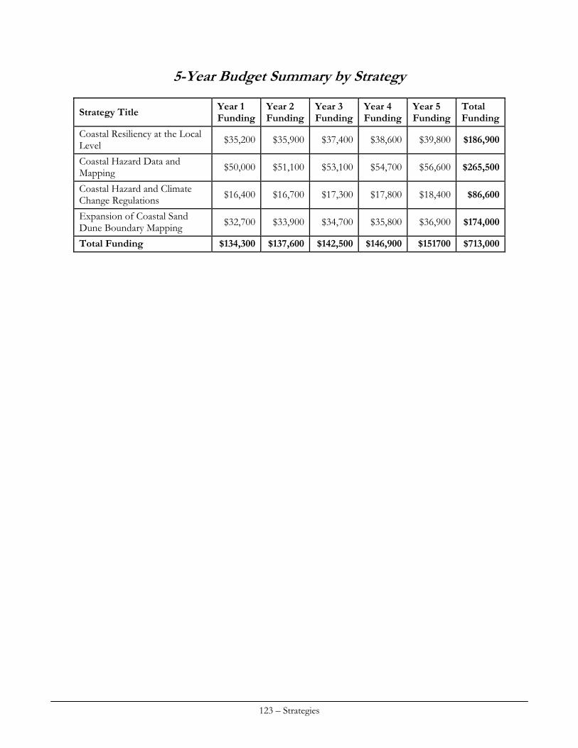
5-Year Budget Summary by Strategy
Year 1 Funding
Year 2 Funding
Year 3 Funding
Year 4 Funding
Year 5 Funding
Total Funding
Strategy Title
Coastal Resiliency at the Local Level $35,200 $35,900 $37,400 $38,600 $39,800 $186,900
Coastal Hazard Data and Mapping $50,000 $51,100 $53,100 $54,700 $56,600 $265,500
Coastal Hazard and Climate Change Regulations $16,400 $16,700 $17,300 $17,800 $18,400 $86,600
Expansion of Coastal Sand Dune Boundary Mapping $32,700 $33,900 $34,700 $35,800 $36,900 $174,000
Total Funding $134,300 $137,600 $142,500 $146,900 $151700 $713,000
123 – Strategies

CUMULATIVE & SECONDARY IMPACTS
Strategy #1: Developing data in support of low impact development and compact mixed use development.
I. Issue Area(s)
The proposed strategy or implementation activities will support the following priority (high or medium) enhancement area(s) (check all that apply):
Aquaculture Cumulative and Secondary Impacts Energy & Government Facility Siting Wetlands Coastal Hazards Marine Debris Ocean/Great Lakes Resources Public Access Special Area Management Planning
II. Program Change Description
A. The proposed strategy will result in, or implement, the following type(s) of program changes (check all that apply):
A change to coastal zone boundaries; New or revised authorities, including statutes, regulations, enforceable policies,
administrative decisions, executive orders, and memoranda of agreement/understanding; New or revised local coastal programs and implementing ordinances; New or revised coastal land acquisition, management, and restoration programs; New or revised Special Area Management Plans (SAMP) or plans for Areas of Particular
Concern (APC) including enforceable policies and other necessary implementation mechanisms or criteria and procedures for designating and managing APCs; and
New or revised guidelines, procedures and policy documents which are formally adopted by a state or territory and provide specific interpretations of enforceable CZM program policies to applicants, local government and other agencies that will result in meaningful improvements in coastal resource management.
B. Program Changes(s) or Implementation Activities
Analysis of the levels of impervious surface coverage throughout the coastal zone will provide the basis of new guidelines promoting adoption of Low Impact Development (LID) techniques and compact mixed use development in designated growth zones to mitigate coastal hazards and protect natural, human resources. New guidelines will be adopted by coastal municipalities.
III. Need(s) and Gap(s) Addressed
This strategy addresses cumulative and secondary impacts, wetlands, and coastal hazards. Information that quantifies the change in impervious surface over time is necessary to measure the success of current programs such as Beginning with Habitat and the Growth Management Act and to develop guidelines for future implementation of these programs. There is currently no consistent
124 – Strategies
method to measure the level and pace of development in the coastal zone; this strategy will provide that method and will build on work already underway through EPA funding. Since major land use decisions and policies are implemented at the local level it is essential to be able to provide data at that same level for consideration in municipal decision-making.
IV. Benefit(s) to Coastal Management
The MCP is hampered in its abilities to promote LID and other resource protection techniques at the municipal level by the lack of municipal level data on the pace and location of development and the impact of that development on both the natural and human ecosystems. Through this strategy, coastal municipalities will be able to more clearly see the value of adopting LID techniques and more effective resource protection strategies in their comprehensive plans and ordinances.
V. Likelihood of Success
Maine is a home rule state and as such it is very difficult to predict what will happen in the municipal arena. However, one of the elements of this strategy is to evaluate the pace and location of development within Beginning with Habitat Focus Areas and this program has enormous support throughout the state at all levels. Many towns are currently updating existing or developing new comprehensive plans even though there are no longer funds from the State to help with the cost of that process – towns clearly see the value of this type of planning and any additional data that can be provided to help towns understand the trends of development and the impacts of that development within their communities will support implementation strategies that address those impacts – such as LID, compact growth areas, cluster subdivision ordinances, tighter shoreland zoning ordinances. MCP will develop technical assistance for towns which connects the level and type of development with impacts to natural and human resources. This assistance will be provided through several different media and many different levels of organization including the regional planning councils, the Maine Association of Planners, code enforcement officers, conservation commissions., comprehensive planning committees.
VI. Strategy Work Plan
Total Years: 5 Total Budget: $78,000 Final Outcome(s) and Products: Technical assistance materials promoting the adoption of LID techniques, compact development and other resource protective strategies in the coastal zone which are incorporated into the Beginning with Habitat toolbox, Code Enforcement Officer Training, comprehensive planning guidance and MCP web page, along with other relevant distribution mechanisms. Year(s): 1-2 Description of activities: 1) MCP land use planners will organize steering committee; 2) GIS analysis of impervious surface data showing change over time relative to municipal growth zones, BwH Focus Areas, water quality designations and other elements identified by the Steering Committee. This analysis will be undertaken by a contractor who will be overseen by a MCP land use planner.
125 – Strategies
Outcome(s): GIS analysis that tell the story of how development and related impacts have proceeded within the coastal zone. Budget: $25,000 Year(s): 2-3 Description of activities: MCP land use planner will work with the Steering Committee to translate the impervious analysis into specific technical assistance materials which are easily understood and meaningful at both the regional and local levels. Outcome(s): Outreach materials Budget: $18,000 Year: 3 Description of activities: MCP land use planner will work with relevant agencies to insure incorporation of analysis results and technical materials into existing programs such as Beginning with Habitat, NEMO, Code Enforcement Officer training, comprehensive planning. Outcome(s): Existing programs deliver consistent messaging around development and impacts to resources along with methods to mitigate those impacts. Budget: $10,000 Year(s): 4-5 Description of activities: Delivery of technical assistance to towns by regional councils and MCP. MCP will track the number of comprehensive plans and ordinances which are revised as a result of this technical assistance. This will be accomplished through grants with the coastal regional councils. Outcome(s): Towns understand and adopt LID techniques, compact and mixed use development zones, and resource protection techniques. Data is collected to help populate one of the currently required CZMPMS Indicators. Budget: $25,000
VII. Fiscal and Technical Needs
A. Fiscal Needs:
A LID model ordinance was prepared by state-funded staff. Proposed section 309 funds, plus 306 funded staff time will be sufficient for this project. B. Technical Needs:
MCP does not have the technical capacity to carry out the GIS analysis of the impervious surface data. State resources beyond consultation are extremely limited due to sustained budget cuts over the last three years. Strategy #2: Evaluating Shoreline Armoring Locations and Impacts
I. Issue Area(s)
The proposed strategy or implementation activities will support the following priority (high or medium) enhancement area(s) (check all that apply):
126 – Strategies
Aquaculture Cumulative and Secondary Impacts Energy & Government Facility Siting Wetlands Coastal Hazards Marine Debris Ocean/Great Lakes Resources Public Access Special Area Management Planning
II. Program Change Description
A. The proposed strategy will result in, or implement, the following type(s) of program changes (check all that apply):
A change to coastal zone boundaries;
New or revised authorities, including statutes, regulations, enforceable policies, administrative decisions, executive orders, and memoranda of agreement/understanding;
New or revised local coastal programs and implementing ordinances;
New or revised coastal land acquisition, management, and restoration programs;
New or revised Special Area Management Plans (SAMP) or plans for Areas of Particular Concern (APC) including enforceable policies and other necessary implementation mechanisms or criteria and procedures for designating and managing APCs; and
New or revised guidelines, procedures and policy documents which are formally adopted by a state or territory and provide specific interpretations of enforceable CZM program policies to applicants, local government and other agencies that will result in meaningful improvements in coastal resource management.
B. Proposed program change(s) or implementation activities
Recent changes to the Natural Resources Protection Act require a full permit for shoreline armoring projects. Previously some projects could proceed via Permit by Rule. This strategy proposes to use a new analysis of past shoreline stabilization projects to more fully understand habitat impacts from current practices. Changes to statutes or regulation and development of new guidance are proposed.
III. Need(s) and Gap(s) Addressed
This strategy will be part of a series of actions which address the need for more complete information on coastal habitats, subsequent analysis of impacts and potential changes to regulations, rules and guidance. This strategy responds to a need identified during NOAA’s review of the Maine Coastal Program.
IV. Benefit(s) to Coastal Management
More complete understanding of how shoreline armoring is affecting coastal habitats and coastal resilience; changes to statutes, regulations or guidance resulting in increased habitat protection/ resilience.
V. Likelihood of Success
Moderate likelihood of success
127 – Strategies
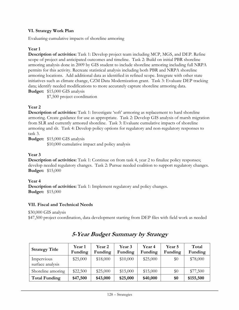
VI. Strategy Work Plan
Evaluating cumulative impacts of shoreline armoring Year 1 Description of activities: Task 1: Develop project team including MCP, MGS, and DEP. Refine scope of project and anticipated outcomes and timeline. Task 2: Build on initial PBR shoreline armoring analysis done in 2009 by GIS student to include shoreline armoring including full NRPA permits for this activity. Recreate statistical analysis including both PBR and NRPA shoreline armoring locations. Add additional data as identified in refined scope. Integrate with other state initiatives such as climate change, CZM Data Modernization grant. Task 3: Evaluate DEP tracking data; identify needed modifications to more accurately capture shoreline armoring data. Budget: $15,000 GIS analysis $7,500 project coordination Year 2 Description of activities: Task 1: Investigate ‘soft’ armoring as replacement to hard shoreline armoring. Create guidance for use as appropriate. Task 2: Develop GIS analysis of marsh migration from SLR and currently armored shoreline. Task 3: Evaluate cumulative impacts of shoreline armoring and slr. Task 4: Develop policy options for regulatory and non-regulatory responses to task 3. Budget: $15,000 GIS analysis $10,000 cumulative impact and policy analysis Year 3 Description of activities: Task 1: Continue on from task 4, year 2 to finalize policy responses; develop needed regulatory changes. Task 2: Pursue needed coalition to support regulatory changes. Budget: $15,000 Year 4 Description of activities: Task 1: Implement regulatory and policy changes. Budget: $15,000
VII. Fiscal and Technical Needs
$30,000 GIS analysis $47,500 project coordination, data development starting from DEP files with field work as needed
5-Year Budget Summary by Strategy
Year 1 Funding
Year 2 Funding
Year 3 Funding
Year 4 Funding
Year 5 Funding
Total Funding
Strategy Title
Impervious surface analysis
$25,000 $18,000 $10,000 $25,000 $0 $78,000
Shoreline amoring $22,500 $25,000 $15,000 $15,000 $0 $77,500
Total Funding $47,500 $43,000 $25,000 $40,000 $0 $155,500
128 – Strategies
ENERGY & GOVERNMENT FACILITY SITING
I. Issue Area(s)
The proposed strategy or implementation activities will support the following priority (high or medium) enhancement area(s) (check all that apply):
Aquaculture Cumulative and Secondary Impacts Energy & Government Facility Siting Wetlands Coastal Hazards Marine Debris Ocean/Great Lakes Resources Public Access Special Area Management Planning
II. Program Change Description
A. The proposed strategy will result in, or implement, the following type(s) of program changes (check all that apply):
A change to coastal zone boundaries; New or revised authorities, including statutes, regulations, enforceable policies,
administrative decisions, executive orders, and memoranda of agreement/understanding; New or revised local coastal programs and implementing ordinances; New or revised coastal land acquisition, management, and restoration programs; New or revised Special Area Management Plans (SAMP) or plans for Areas of Particular
Concern (APC) including enforceable policies and other necessary implementation mechanisms or criteria and procedures for designating and managing APCs; and
New or revised guidelines, procedures and policy documents which are formally adopted by a state or territory and provide specific interpretations of enforceable CZM program policies to applicants, local government and other agencies that will result in meaningful improvements in coastal resource management.
B. Program Changes(s) or Implementation Activities
This strategy involves in part on-going work to implement state laws (P.L. 2009, ch. 270 and P.L. 2009, ch. 615) which stemmed from legislation submitted by Governor Baldacci based on recommendations of his Ocean Energy Task Force. In pertinent part, P.L. 2009, ch. 270 creates state general permits for testing offshore wind energy technologies in designated places in Maine’s coastal waters and tidal power technologies eligible for approval under FERC’s permit process for hydrokinetic pilot projects. P.L. 2009 ch. 615, which focused on state goals, policies, and regulatory streamlining to facilitate siting of commercial scale offshore wind and other renewable ocean energy projects, in pertinent part directs the Bureau of Parks and Lands (BPL) to amend its submerged lands leasing rules to establish a fee schedule for leasing submerged lands for renewable ocean energy projects “that balances state goals of assurance of fair compensation for use and mitigation of potential adverse effects on or conflict with existing uses of state-owned submerged lands that are held in trust for the people of the State with state renewable ocean energy-related goals. . . .”
129 – Strategies
In 2009, NOAA approved the pertinent general permit-related provisions of P.L. 2009, ch. 270 as routine program changes (RPC). The State intends to include pertinent provisions of P.L. 2009, ch. 615 in its next RPC submission. Described below as elements of the work plan, these implementation activities involve:
Subject to available funding and in the context of related coastal and marine spatial planning efforts, multi-beam sonar mapping, benthic habitat modeling and substrate ground-truthing, and creation of baseline biological information for one or more areas in the Gulf of Maine potentially suitable for deep-water wind energy generation, and dissemination this data through a publicly available online portal;
Monitoring and assessment of the efficacy of the FERC-State MOU regarding environmental review of tidal power projects; and
On-going participation by coastal staff at SPO and DMR and SPO natural resources economists in BPL rulemaking under P.L. 2009, ch. 615 (if not completed prior to commencement of this 309 period) to establish submerged lands lease fees for renewable ocean energy projects that ensure balanced consideration of public trust issues, in part by appropriately accounting for and addressing fisheries-related issues.
In each case, the implementation activities outlined will help ensure achievement of the core objective of these program changes: facilitate siting of renewable ocean energy test projects as a critical step in the process for securing the renewable energy, economic development-related, climate change-related and other environmental benefits of this industry for the State.
III. Need(s) and Gap(s) Addressed
This strategy, along with closely related elements in the Ocean Resources section, directly responds to and proposes specific actions that target the following high-priority needs identified in this report’s Assessment:
Establishment of an on-line Coastal Atlas that facilitates access to the best available information on renewable ocean energy-related siting issues - a key tool to address data and related communications needs;
Active engagement of Maine with other states in the region, federal agencies, and stakeholders to advance coastal marine spatial planning that identifies preferred areas for siting offshore wind generation facilities - a key tool for making optimal use of the marine environment and avoiding and minimizing potential use conflicts and adverse effects on natural resources values;
Improvement in the existing governance framework for offshore wind energy through well-coordinated state-federal environmental review and resulting streamlining of leasing and permitting processes - process improvements widely seen as essential to the timely and efficient development of the renewable ocean energy industry and realization of its many potential environmental and economic benefits; and
Active outreach to and engagement with marine stakeholders and wind developers to promote dialogue, mutual understanding - a foundation for identifying opportunities for minimizing conflicts and promoting well-informed and efficient siting processes and decisions.
130 – Strategies
IV. Benefit(s) to Coastal Management
As noted in the foregoing Assessment, renewable ocean energy development is a subject of significant interest in Maine and elsewhere, and is likely to remain so in the foreseeable future at the global, national, regional, state, and local levels. Building on Maine’s leadership in the renewable ocean energy field, the State’s public and private sectors are each striving, in part through collaborative, public-private partnerships, to realize the enormous potential benefits of deep-water ocean wind, tidal, and in time perhaps other emerging ocean renewable energy technologies. Maine’s OETF, the offshore wind industry, academics, and others have emphasized the need for significant public policy work, focused on improvement of governance systems and development of information needed to inform public and private decisions on siting issues, to facilitate efficient and well-site development of renewable ocean energy facilities. This strategy and the work plan elements it details aim squarely at addressing key problems, a number of which require attention and action at the regional and national levels. Assurance that renewable ocean energy projects may be sited efficiently, with appropriate consideration to existing uses of the marine environment and avoidance, minimization, and compensation for undue adverse effects, has many potential benefits for the environment, stakeholders, and coastal managers. Timely and efficient siting of deep-water wind projects, through needed improvements in decision making processes and related data and information resources, has significant potential to support achievement of national and state carbon dioxide emissions-related energy goals, as well as transition, over time, to use of electric power to address transportation and heating needs, which comprise by far the largest share of the energy budget of Maine households. Coastal and marine spatial planning has great potential to identify potential conflicts and opportunities for optimal resolution of them in ways that facilitate siting in a balanced manner that respects and supports traditional, existing marine uses and natural resources values. Better information, shared understanding of opportunities and constraints, and improved decision making processes, built on enhanced federal-state cooperation, each have notable value for coastal managers faced with appropriately balancing development and conservation goals with appropriate consideration for regional and national as well as state needs and objectives.
V. Likelihood of Success
Governor Baldacci’s establishment of the OETF, tasked with developing a strategy to make Maine an leader in the renewable ocean energy field; the work of the task force itself, which featured inter-agency cooperation and significant problem solving-oriented contributions from its members, drawn from both the public and private sector, as well as the public; and resulting legislation aimed at advancing the renewable ocean energy through testing in state waters, regulatory streamlining, and establishment of ambitious, quantitative offshore wind energy generation goals (cite); and Maine voters’ recent approval of a $26.5 bond to energy independence and efficiency efforts, including the University of Maine’s on-going deep-water wind energy testing and development initiatives, all evidence Maine’s strong interest and commitment to and growing experience in renewable ocean energy matters. Community support for and direct involvement with the Ocean Renewable Power Company’s (ORPC) commercial tidal power development project in Eastport, Maine, reflects Maine’s abiding interest in and position in the vanguard concerning in-stream tidal power development. Significant federal grant awards and other federal support for the University of Maine’s deep-water wind and other renewable ocean energy-related research and for ORPC’s tidal
131 – Strategies
power project, reflect national recognition that there tremendous potential in Maine for nationally significant advances in the field of renewable ocean energy development, as well as the expertise, leadership, and commitment needed to realize that potential. SPO intends to keep the Governor, Legislature, and other state decision-makers well informed on renewable ocean energy policy developments, through the natural resources subcabinet and Land and Water Resources Council, for example, and to assist in their identification of issues and development of state policy to address them. The State’s statutory goals for offshore wind energy development, and related provisions in the P.L. 2009, ch. 615 and recommendations of the OETF, provide a foundation for on-going state efforts. SPO intends that envisioned coastal and marine spatial planning and other work regarding potential siting of wind energy facilities on the OCS will involve significant outreach to and dialogue with marine stakeholders. The complete success of this strategy depends in part on federal funding in addition to that available under Section 309 is needed, particularly as concerns data and information needs. Affirmative steps by federal agencies, and potentially related changes in federal law, rules, or policies, that better coordinate their work among themselves and with coastal states are also needed. Achievement of these elements of the strategy is outside Maine’s sole control. Recognizing this challenge, on-going, active engagement with other coastal states in the region and federal agencies, at the regional and national level, regarding data and information needs and needed improvements in the federal governance framework is a central feature of this strategy.
VI. Strategy Work Plan
Total Years: 5 Total Budget: $164,500 Final Outcome(s) and Products: Year(s): 1-5 Description of activities: Active involvement in national, regional, and consequent and related state development initiatives aimed at close coordination, streamlining, and enhanced predictability of federal leasing and permitting decisions and related NEPA and other environmental reviews of offshore wind and other renewable ocean energy development proposals.
Maine’s Ocean Energy Task Force (OETF) (link to the OETF’s final report at www.maine.gov/spo/specialprojects/OETF/index.htm) identified enhancement of regulatory certainty and streamlining of federal leasing and environmental review and approval processes as essential to the timely and orderly growth of the renewable ocean energy industry. Active involvement of coastal states is needed to ensure that the need for targeted improvements at the federal level is well-articulated in relation to and appropriately coordinated with state renewable energy policy, environmental, and economic development policies. In accordance with Maine’s acknowledged leadership in this area, particularly as concerns advanced deep-water wind energy technology, SPO coastal staff, in cooperation with the Governor’s office as appropriate, will continue to participate actively in pertinent national and regional as well state-level policy forums to ensure these perspectives are considered.
132 – Strategies
Principal forums for on-going involvement in key policy development initiatives include: the Northeast Regional Oceans Conference (NROC) and its energy subcommittee; the DOI-sponsored Atlantic Offshore Wind Energy Consortium (AOWEC) (link to pertinent
MOU among, MMS and Maine and other East Coast states – www.mms.gov/ooc/PDFs/AtlanticConsortiumMOU.pdf), and related subcommittees and projects; and
the National Ocean Council (NOC).
In particular, coastal staff at SPO, through NROC and other appropriate vehicles, will coordinate Maine’s policy-level work on Gulf of Maine-oriented coastal and marine spatial planning (CMSP) pursuant to the terms of NOC’s anticipated final National Ocean Plan and related agenda. SPO anticipates that key elements of policy development initiatives will include:
review of current state and federal laws, policies, and guidelines regarding siting renewable ocean energy development;
development and implementation of proposals to clarify, coordinate, and streamline as appropriate leasing and permitting decision making requirements; and
through consultation with MMS and other pertinent state and federal agencies and Indian tribes, identification to the extent practicable of one or more OCS areas proximate to Maine that are well-suited to development of commercial scale deep-water wind energy generation facilities with minimal adverse effects on other natural resources values and existing marine uses.
In the context of these national and regional policy development initiatives, the State plans to continue its efforts, in cooperation with the University of Maine and others, to:
identify gaps in data and information needed to inform public and private decisions on siting-related issues and development and implementation of proposals those knowledge gaps; and
develop a Coastal Atlas, available via an on-line public portal, to facilitate dissemination and use of the best available information for siting-related decisions.
See Ocean Resources section for a description of this data collection and analysis, and related CMSP actions.
In addition, in conjunction with related CMSP efforts and work on national and regional governance issues described above, the State will explore the efficacy of and opportunities for development of a Special Area Management Plan (SAMP) designed to facilitate siting of deep-water wind energy generation facilities on federal OCS areas adjacent to Maine. Outcome(s):
Regionally-oriented and streamlined federal-state processes for leasing and permitting offshore wind energy development, potentially pursuant to an Memorandum of Understanding or comparable mechanism;
Maine Coastal Atlas which provides improved information resources and guidance to inform siting decisions and is appropriately integrated with pertinent regional and national information resources; and
Identification of one or more locations on the federal OCS proximate to Maine suitable for deep-water offshore wind energy development and, potentially, development of a SAMP to facilitate siting of deep-water wind energy in those area(s).
Budget: SPO staff (see Ocean Resources section for budget re: data and information and related CMSP actions)
133 – Strategies
Year: 1 Description of activities: Review and update as appropriate federal consistency review provisions as applied to renewable ocean energy projects.
In consultation with DEP and other state agencies, and OCRM and other federal agencies as appropriate, coastal staff at SPO will review current Maine coastal program provisions as applied to federal leasing and permitting of offshore wind and other renewable ocean energy projects and propose routine program changes, if any, needed to ensure efficient and effective review in light of pertinent state renewable ocean energy goals, OETF policy recommendations, and pertinent federal law, including MMS’s OCS renewable energy project leasing rules. Outcome(s): Submission to NOAA/OCRM of a routine program change to revise, if and as deemed appropriate, the Maine Coastal Program's federal consistency review provisions regarding renewable ocean energy projects. Budget: SPO staff time Year: 1 Description of activities: Develop information for the Bureau of Parks and Lands’ consideration (BPL) in rulemaking to establish a lease fee schedule for offshore wind and other renewable ocean energy projects.
In conjunction with DMR and SPO natural resources economists, coastal staff at SPO will continue as necessary efforts to develop economics-oriented information for consideration by the BPL in its rulemaking under P.L. 2009, ch. 615, to establish submerged lands lease fees for renewable ocean energy projects to ensure balanced consideration of Public Trust issues, including assurance that lease fees appropriately account for and address fisheries effects. Outcome(s): A submerged lands lease fee schedule that appropriately balance state interests in renewable ocean energy development and traditional Public Trust uses of state-owned submerged lands, as per P.L. 2009, ch. 615. Budget: SPO and DMR staff time Year(s): 1-2 Description of activities: Assessing efficacy of program changes regarding tidal, wave, and other renewable ocean energy development activities.
In consultation with DEP, coastal staff at SPO will monitor implementation of the FERC-State MOU regarding tidal in-stream energy conversion (TISEC) projects and identify, propose, and negotiate with FERC and other agencies as appropriate for changes necessary to facilitate streamlined and environmentally-sound review and approval of TISEC projects in Maine.
In addition, in consultation with DEP and other state agencies, coastal staff at SPO will monitor development of wave energy conversion and other renewable ocean energy technologies to determine need for and develop as appropriate a DEP-administered general permit to facilitate test projects. Outcome(s): Policy recommendations and amended MOU, as appropriate. Budget: SPO staff time $2,500 - meeting facilitation re: potential MOU changes
134 – Strategies
Year(s): 1-3 Description of activities: Investigate and develop policy recommendations regarding the role of insurance in facilitating or hindering shared use of the ocean by renewable ocean energy and commercial fishing and other existing human uses.
Integration of renewable ocean energy development with traditional, existing uses of the ocean environment presents significant challenges to policy makers and developers alike. A full-scale commercial offshore wind energy development requires some degree of occupation and control of a large, contiguous ocean area. In accordance with the Public Trust Doctrine, both state submerged lands and federal Outer Continental Shelf lands are held in trust and managed accordingly through issuance of leases, permits, and other approvals that in various ways necessitate avoidance and minimization and in some instances compensation for potential adverse effects on existing uses, such as commercial fishing. If a commercial fisherman or other marine user has used the geographic space that an offshore wind facility proposes to lease, develop, and occupy the potential for real or perceived conflict is evident. Public processes regarding OCS leasing and related federal and state permitting provide forums in which potential use conflicts may be addressed.
One aspect of the question of potential conflicts between offshore wind development and commercial fishing and other existing uses concerns the economic risks related to collision and other accidents that these activities may pose for one another if conducted in the same area. Businesses typically manage these kinds of risks through various forms of insurance. The lack of insurance, if required, to obtain a required license or permit or lease, to secure project financing, or to maintain and continue existing activities in an area may limit or affect how renewable ocean energy development and traditional uses share the ocean.
This strategy is focused on developing a white paper that explores the potential for insurance-related requirements to affect the siting of renewable ocean energy projects in relation to other traditional uses of the marine environment and that provides related policy recommendations. The white paper would address the following core questions and related matters:
Are there any documented instances of damage to offshore wind energy facilities and/or commercial fishing vessels? If so, what types of vessels, fishing gear, and wind machines and infrastructure were involved? Were any such incidents followed by changes in fishing or wind project operations intended to avoid future problems?
Is there documented information on insurance requirements or related risk management measures (e.g., exclusion of fishing around turbines or cables) for European offshore wind facilities? How are these issues addressed for the Cape Wind project, for example?
Has the fishing community or a resource management agency(ies) developed any suggestions (best practices) for minimizing potential risks and use conflicts?
Which, if any, federal or state laws applicable to offshore wind energy development require the developer to obtain liability or other insurance as condition of a required license, permit, or other approval? Please provide citations for and a summary of any such requirements. Are there federal or state laws that require liability or other insurance for commercial fishing, shipping, or other marine business activity that may be expected to occur in or around an offshore wind energy facility?
Regardless of legal requirements to do so, under standard business practices and financing arrangements, what type of insurance would be needed for offshore wind energy development and existing marine activities, respectively, is located in the same area?
135 – Strategies
Would additional or different insurance be required for existing marine activities that would be conducted in or around an offshore wind energy facility? Based on the experience with Europe's offshore wind industry and other pertinent information, what might be the cost of such insurance and to what extent would it add to existing activities' otherwise applicable insurance costs?
Is there information that suggests that insurance providers may require restriction of activities around offshore wind energy facilities as a condition of providing coverage for an offshore wind energy facility? Conversely, is there information that providers of insurance for commercial fishing activities might limit or charge an enhanced premium for coverage regarding activities in or around an offshore wind energy facility? If so, what types of restrictions (e.g., exclusion zone) have been required by insurance providers and what was the basis for determining the nature, extent and duration of such restrictions?
Outcome(s): White paper(s) detailing research findings; and Workshop meeting, for presentation of research findings and discussion to inform
development of policy recommendations, among key industry representatives (offshore wind, commercial fishing, shipping/cruise boat, and insurance sectors) and pertinent federal and state decision-making agencies; and
Policy recommendations, including legislation as appropriate, for presentation to and consideration by the appropriate forum(s).
Budget: SPO staff time $5,000 – contract for legal research (consultant, intern, or law student) $10,000 – contract for investigation of insurance and related financing requirements applicable to offshore wind industry in Europe and United States $1,000 – workshop (room rental and related expenses; facilitator)
Year(s): 1-3 Description of activities: Clarify the nature and scope of Maine municipalities’ authority to regulate and tax renewable ocean energy development.
As emphasized by the OETF in its final report, the location and reach into Maine’s coastal waters of Maine municipalities’ boundaries, which are set for each municipality by its individual legislative charter, are not clear and consistent, or well-understood. Municipalities’ taxation and regulatory authority are directly related to activities’ occurrence within their boundaries. Consequently, ambiguity, confusion, or dispute regarding such boundaries may lead directly to disputes over regulatory and taxation authority that impede the orderly growth and development of Maine’s renewable ocean energy industry while embroiling municipalities, developers, and the State in costly and time-consuming administrative and legal proceedings.
In consultation and collaboration with the Maine Municipal Association (MMA), the State Bureau of Taxation and other agencies and experts, coastal staff at SPO will develop policy recommendations aimed at addressing identified ambiguities or inconsistencies regarding Maine municipalities’ maritime boundaries and related regulatory and taxation authorities in an equitable manner that appropriately reflects Maine’s “home rule” tradition and enhances the predictability of the state regulatory and taxation framework. The effort has the following major elements:
136 – Strategies
MMA review of municipal charters to identify potential ambiguities and inconsistencies; Consideration of analysis presented to the Legislature by the Bureau of Revenue Services
pursuant to P.L. 2009, c. 615, section C-1, regarding whether and under what circumstances renewable ocean energy-generating machinery, equipment and related components that are in transit to be located in, on or above state submerged lands are covered by existing state tax exemptions related to goods in transit;
Subsequent MMA-SPO meetings to discuss potential ambiguities and inconsistencies identified and identify key issues and a range of options to address them;
One or more facilitated meetings of MMA and SPO to identify mutually agreeable options to address and resolve key issues; and
Collaborative development of policy recommendations, including legislation as appropriate, for presentation of mutually agreeable options in appropriate the forum(s).
Outcome(s): Development of an article for publication in the Maine Townsman, an MMA-published
periodical that informs and guides Maine municipalities on policy issues, that outlines the marine boundary issue, its implications, and optimal means to address key related issues; and
Policy recommendations, including legislation as appropriate. Budget: SPO staff time $5,000 – contract for facilitator
VII. Fiscal and Technical Needs
A. Fiscal Needs:
Section 309 funding is not adequate to implement all aspects of the above-described strategy which incorporates by reference data collection, assessment, and publication needs detailed in the Ocean Resources section. SPO’s efforts, in cooperation with DMR, the University of Maine, and others, to obtain these additional necessary funds are outlined in the Ocean Resources section. B. Technical Needs:
With limited exceptions, the State has the technical knowledge, skills, and equipment necessary to execute the proposed strategy. As described above, the strategy calls for a small amount of funding for focused legal and related research regarding the relationship between potential use-related conflicts in sting renewable ocean energy projects and insurance requirements, as well as meeting facilitation assistance.
137 – Strategies
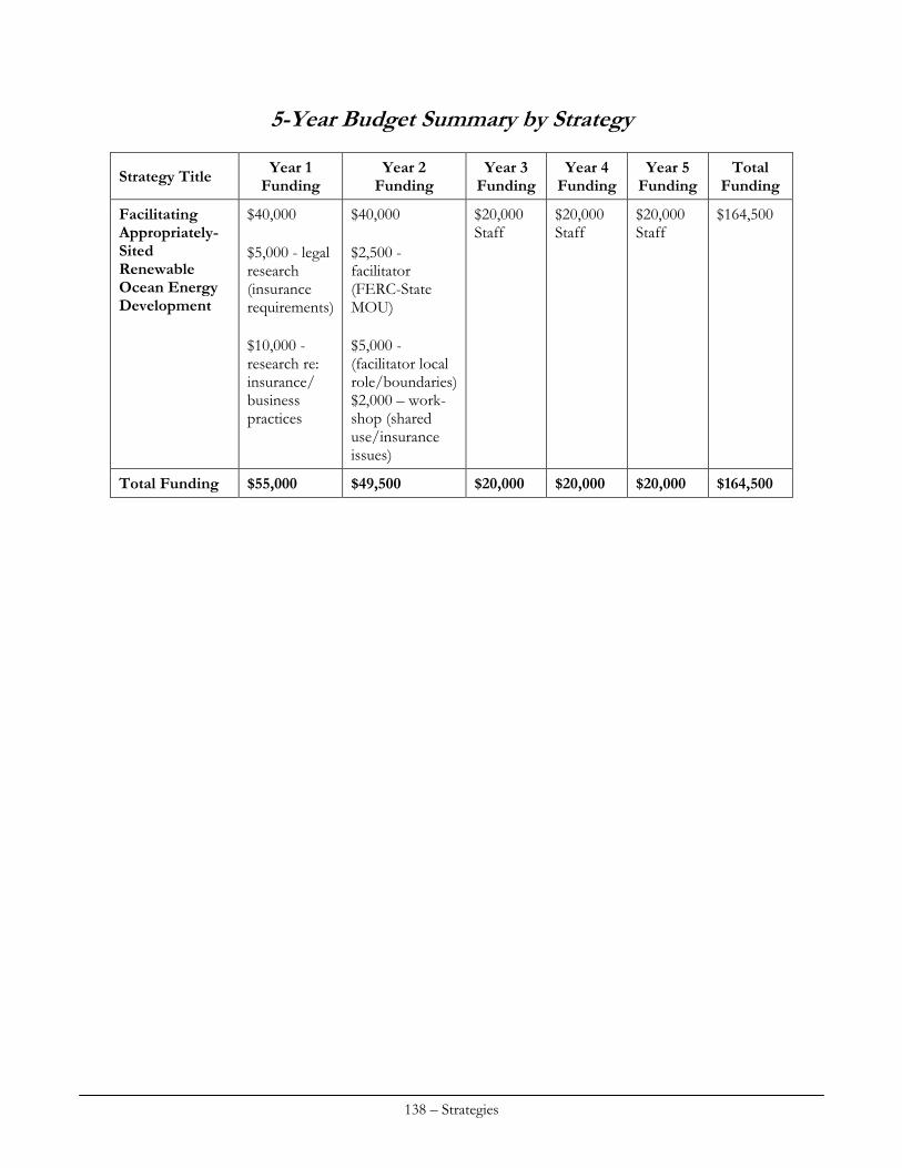
5-Year Budget Summary by Strategy
Year 1 Funding
Year 2 Funding
Year 3 Funding
Year 4 Funding
Year 5 Funding
Total Funding Strategy Title
$40,000 $5,000 - legal research (insurance requirements) $10,000 - research re: insurance/ business practices
$40,000 $2,500 - facilitator (FERC-State MOU) $5,000 - (facilitator local role/boundaries) $2,000 – work-shop (shared use/insurance issues)
$20,000 Staff
$20,000 Staff
$20,000 Staff
$164,500 Facilitating Appropriately-Sited Renewable Ocean Energy Development
Total Funding $55,000 $49,500 $20,000 $20,000 $20,000 $164,500
138 – Strategies
OCEAN RESOURCES
Strategy #1: Secure High‐level Policy Directive regarding Coastal and Marine Spatial Planning (CMSP) Coastal staff at SPO will work with new administration (next Maine Governor takes office in January 2011) to develop a directive (executive order or proposed bill) for SPO and DMR to jointly lead and complete by a date certain an inter-agency CMSP initiative that, building on the work of the bay management study and Ocean Energy Task Force, and related efforts, has the following main elements:
Coordination of agency efforts to collect and address gaps in data and information identified as integral to effective CMSP;
Development, implementation, and maintenance of an on-line tool (Maine Coastal and Marine Atlas) to make the best available and continually improving coastal and marine resource data available to public and private decisions makers and provide the foundation for state CMSP efforts;
Public engagement to address data gaps regarding existing coastal uses, identify shareholder priorities, values, and concerns, facilitate informed public participation in CMSP efforts;
Development of policy recommendations, informed by data and related spatial analysis and stakeholder and advisory groups, for program improvements, including potentially changes in core laws and regulations, needed to facilitate achievement of state renewable ocean energy goals, ensure appropriate management of uniquely productive or unique coastal and marine habitats, and address other articulated CMSP-related policy goals aimed at balancing conservation and development;
Coordination of state-focused CMSP efforts with regionally-oriented CMSP through continued active participation in the NROC and related efforts; and
Development of a Maine Ocean Plan that, informed by spatial analysis of the best available information, including input from marine harvesters and other public stakeholders, articulates Maine ocean policy, directs state agencies to review and recommend changes in laws and rules that they administer need to conform to and advance that policy, and identifies for public and private sector planning and decision making purposes:
o potential constraints and opportunities for development of renewable ocean energy facilities and related infrastructure in Maine's coastal waters and adjoining federal waters;
o unique and uniquely productive coastal and marine habitat and fisheries; and
o other significant resources and related uses.
139 – Strategies
I. Issue Area(s)
The proposed strategy or implementation activities will support the following priority (high or medium) enhancement area(s) (check all that apply):
Aquaculture Cumulative and Secondary Impacts Energy & Government Facility Siting Wetlands Coastal Hazards Marine Debris Ocean/Great Lakes Resources Public Access Special Area Management Planning
II. Program Change Description
A. The proposed strategy will result in, or implement, the following type(s) of program changes (check all that apply):
A change to coastal zone boundaries; New or revised authorities, including statutes, regulations, enforceable policies,
administrative decisions, executive orders, and memoranda of agreement/understanding; New or revised local coastal programs and implementing ordinances; New or revised coastal land acquisition, management, and restoration programs; New or revised Special Area Management Plans (SAMP) or plans for Areas of Particular
Concern (APC) including enforceable policies and other necessary implementation mechanisms or criteria and procedures for designating and managing APCs; and
New or revised guidelines, procedures and policy documents which are formally adopted by a state or territory and provide specific interpretations of enforceable CZM program policies to applicants, local government and other agencies that will result in meaningful improvements in coastal resource management.
B. Program Changes(s) or Implementation Activities
The State would request inclusion of legislation enacting a CMSP directive among the core laws of its coastal program. Like several other core law authorities, such as the State’s Coastal Management Policies Act, it would not itself provide enforceable policies but articulate state policies to be addressed through enforceable polices under state environmental laws and program activities. As envisioned, such a legislative mandate (or executive order) would direct pertinent state agencies to review the laws and regulations they implement and develop recommended changes to implement stated Maine ocean policies.
III. Need(s) and Gap(s) Addressed
Governor Baldacci’s Ocean Energy Task Force recommended that the State create “an on-line Coastal Atlas to make the best available and continually improving project planning-related information available to public and private decision makers” and pursue “funding opportunities to engage in marine spatial planning in selected state and federal waters that appear promising for offshore wind development.” However, there is no state law or executive order that directs SPO or other MCP agencies to undertake these actions. Colleagues with the Massachusetts CZM program have advised that clear direction from the Governor and Legislature was a major factor underlying the successful development of the Massachusetts Ocean Plan. Enactment of a Maine law or executive order that provided a CMSP mandate would fill this gap in policy-level CMSP direction at the state level.
140 – Strategies
IV. Benefit(s) to Coastal Management
While not essential, clear articulation of state CMSP goals and objectives in state law or an executive order would assist state agencies in prioritizing and making necessary resources available and provide agencies and stakeholders alike a framework to guide planning efforts and implementation actions in relation to state statutory renewable ocean energy development and other goals.
V. Likelihood of Success
Major Maine businesses and industries, University of Maine researchers, non-profit conservation and community organizations, and state policy makers have all, from diverse perspectives, expressed support for continued growth and development of Maine’s emerging renewable ocean energy industry. Likewise, there is broad recognition that CMSP can be a powerful tool for facilitating renewable ocean energy development and advancing other conservation and development objectives in a well-balanced manner. The Governor and Legislature, as appropriate, may reasonably be expected to consider these interests, among others, in deciding whether to provide a CMSP mandate. Accordingly, this strategy appears to have a reasonable likelihood of success.
VI. Strategy Work Plan
Total Years: 1 Total Budget: $20,000 Final Outcome(s) and Products: State law or executive order, as described above, directing SPO and DMR to jointly undertake and manage a state CMSP initiative and develop the resulting Maine Ocean plan Year: 1 Description of activities: Meetings with senior, policy level state officials and stakeholders; preparing draft executive order and/or legislation; participation in legislative process (potential) Budget: $20,000 Strategy #2: Development of Data Protocols to Inform the Maine Ocean Plan As discussed above, gaps in key data and information present obstacles and challenges to effective coastal and marine spatial planning. Improved understanding of sea floor characteristics is needed to inform energy facility siting, fisheries management, marine conservation, and other CMSP-related decisions. This strategy addresses this gap through an innovative, pilot approach to benthic habitat characterization that involves resource harvesters in data collection efforts. The pilot has potential to inform and result in program changes, if any, needed to support a comparable approach to other marine resources data collection and assessment efforts.
141 – Strategies
I. Issue Area(s)
The proposed strategy or implementation activities will support the following priority (high or medium) enhancement area(s) (check all that apply):
Aquaculture Cumulative and Secondary Impacts Energy & Government Facility Siting Wetlands Coastal Hazards Marine Debris Ocean/Great Lakes Resources Public Access Special Area Management Planning
II. Program Change Description
A. The proposed strategy will result in, or implement, the following type(s) of program changes (check all that apply):
A change to coastal zone boundaries; New or revised authorities, including statutes, regulations, enforceable policies,
administrative decisions, executive orders, and memoranda of agreement/understanding; New or revised local coastal programs and implementing ordinances; New or revised coastal land acquisition, management, and restoration programs; New or revised Special Area Management Plans (SAMP) or plans for Areas of Particular
Concern (APC) including enforceable policies and other necessary implementation mechanisms or criteria and procedures for designating and managing APCs; and
New or revised guidelines, procedures and policy documents which are formally adopted by a state or territory and provide specific interpretations of enforceable CZM program policies to applicants, local government and other agencies that will result in meaningful improvements in coastal resource management.
B. Program Changes(s) or Implementation Activities
This pilot project involves development of protocols for collection and assessment of benthic habitat-related data and information in cooperation with Maine-licensed marine harvesters and development of a standard model for benthic habitat characterization. DMR, DEP, BPL, and LURC will participate in the development of and formally adopt the protocols and standard model for habitat characterization as rules or agency guidance, as applicable, and review and recommend related necessary changes to its regulations and statutory authorizations, if any, that are needed to use protocols and model for planning and management purposes. Information gathered and assessed under these protocols will inform and enhance current fisheries management efforts and provide key information for use in developing the Maine Ocean Plan. The activities proposed under this strategy involve the creation of a joint DMR-SPO research and analysis program to facilitate the collection, standardization, and the synthesis of collected benthic data. The proposed program would initiate the collection of multi-beam sonar mapping data and benthic and substrate ground-truthing data using equipment recently purchased by DMR and SPO. DMR and SPO would jointly adopt, in consultation with DEP, LURC, and BPL, protocols regarding training, methods, and provisions of funding to employ Maine-licensed marine harvesters and other coastal stakeholders to collect this data using a transferable data collection harness to supplement data that will be collected by the DMR on its own vessels. This program is designed to provide harvesters an opportunity for direct involvement in collecting key data to inform CMSP and
142 – Strategies
related resource management decisions. This collaboration would foster transfer of knowledge and experience among coastal users and coastal managers and facilitate subsequent dialogue on CMSP-related issues. In addition, this strategy would fund the synthesis of prior pertinent benthic habitat modeling. An advisory group of academics, state and federal coastal managers, representatives of pertinent non-profit organizations, and other relevant experts would identify or develop a scientifically rigorous standard model for benthic habitat classification. This advisory group would also identify priority areas for benthic mapping and ground-truthing.
III. Need(s) and Gap(s) Addressed
This strategy will address several significant information and information assessment gaps regarding coastal and marine habitat management and planning. There is no standard benthic habitat classification model for in the Gulf of Maine. Although there are several publications that outline a methodology for such modeling, these publications are out-of-date (some are more than 30 years old) and not entirely consistent. This lack of an agreed-upon model makes fisheries management, coastal and marine habitat management and protection, and related coastal and marine planning efforts difficult and potentially inaccurate. The proposed pilot multi-beam sonar seabed mapping and development of protocols for related data collection and an agreed-upon benthic habitat classification model will directly address this problem while providing approaches potentially transferable to other data collection efforts.
IV. Benefit(s) to Coastal Management
Establishment of benthic habitat identification methodologies and protocols will contribute to increased scientifically rigorous methods used in fisheries management and regulatory decisions, as well as more informed decisions about siting ocean development. This strategy will also aid in the identification of baseline data for several species through progress in completing a multi-beam sonar mosaic of the Gulf of Maine. Improved understanding of benthic habitat conditions is critical for coastal and marine spatial planning for the Maine Ocean Plan. Implementation of this strategy will also foster cooperation and collaboration among harvesters and state resource managers and lay the foundation for forge continued mutually beneficial collaboration on CMSP-related efforts. In addition, this information will aid in public and private decision making on navigation, marine safety, energy facilities siting, and other coastal and marine issues.
V. Likelihood of Success
The likelihood of this program succeeding is high. DMR and SPO have jointly purchased the necessary multi-beam sonar equipment. The strategy’s proposed contractual and pilot area mapping steps will be relatively simple to accomplish. Interpretation of the data, establishment of the benthic habitat methodologies and protocols, and synthesis of both existing literature and expert knowledge pose more significant, though not insurmountable, challenges. Marine harvesters concerned with how CMSP and related resource management efforts may affect their livelihood may reasonably be expected to take advantage of the opportunities for involvement provided by this strategy.
143 – Strategies
VI. Strategy Work Plan
Total Years: 3 Total Budget: $250,000 Final Outcome(s) and Products: Benthic habitat data collection methods and protocols; standardized benthic habitat models. Year: 1 Description of activities: 1) Development by DMR and SPO, in consultation with DEP, LURC, and BPL (state agencies with permitting and leasing authority in the marine environment), of data collection protocols. The protocols will be designed to optimize the utility of the data for CMSP, as well as regulatory, scientific research, and other public purposes. 2) Formation of collaborative research advisory group to begin synthesis of benthic habitat literature and knowledge and to make recommendations on a standard methodology for benthic habitat characterization and specific ocean areas for multi-beam sonar mapping and related ground-truthing. 3) Review by DMR, DEP, LURC, and BPL of pertinent laws and rules they administer and recommendation of changes, if any, needed to formally adopt the protocols and model; and formal adoption of protocols and model, as applicable. Outcome(s): Formation of a Benthic Habitat Advisory Committee, identification of pilot mapping areas, completion of literature and knowledge synthesis; benthic habitat data collection protocols; agreed-upon draft benthic habitat characterization model; and recommendations for related changes, if any, in DMR, DEP, LURC, and BPL laws or rules. Budget: $50,000 Year: 2 Description of activities: Collaborative mapping and ground-truthing of pilot areas selected in consultation with the Benthic Habitat Advisory Committee; additional work to complete development of the benthic habitat characterization model; proposed rulemaking or legislation to make needed changes, if any, in DMR, DEP, LURC, and/or BPL laws or rules. Outcome(s): Partial completion of mapping and benthic habitat characterization models for select areas; and literature synthesis complete. Budget: $100,000 Year: 3 Description of activities: Collaborative mapping and ground-truthing of pilot areas; application of the model to data collected from multi-beam sonar mapping. Outcome(s): Completion of pilot area mapping project and overlay of models based on ground-truth data and sonar data on spatial map of the Gulf of Maine. Budget: $100,000
VII. Fiscal and Technical Needs
A. Fiscal Needs:
The 309 funds requested are not solely sufficient to fully implement this strategy. SPO and DMR are seeking additional funds for necessary field work and data analysis from a variety of sources. B. Technical Needs:
Contractors and technical advisory team members will supplement state agency staff.
144 – Strategies
Strategy #3: Maine Coastal and Marine Atlas: Development of an On‐line Tool as Foundation for the Maine Ocean Plan
I. Issue Area(s)
The proposed strategy or implementation activities will support the following priority (high or medium) enhancement area(s) (check all that apply):
Aquaculture Cumulative and Secondary Impacts Energy & Government Facility Siting Wetlands Coastal Hazards Marine Debris Ocean/Great Lakes Resources Public Access Special Area Management Planning
II. Program Change Description
A. The proposed strategy will result in, or implement, the following type(s) of program changes (check all that apply):
A change to coastal zone boundaries; New or revised authorities, including statutes, regulations, enforceable policies,
administrative decisions, executive orders, and memoranda of agreement/understanding; New or revised local coastal programs and implementing ordinances; New or revised coastal land acquisition, management, and restoration programs; New or revised Special Area Management Plans (SAMP) or plans for Areas of Particular
Concern (APC) including enforceable policies and other necessary implementation mechanisms or criteria and procedures for designating and managing APCs; and
New or revised guidelines, procedures and policy documents which are formally adopted by a state or territory and provide specific interpretations of enforceable CZM program policies to applicants, local government and other agencies that will result in meaningful improvements in coastal resource management.
B. Program Changes(s) or Implementation Activities
This strategy involves creation of an on-line data portal, the Maine Coastal and Marine Atlas (Atlas) that will provide the foundation for public engagement, spatial analysis, and other vital steps toward development of the Maine Ocean Plan. This strategy involves implementation of existing 309-supported policies, including those developed by the Ocean Energy Task Force (OETF) and resulting legislation. PL 2009 c. 615 calls for siting of 5 GW of offshore wind power by 2030 and made changes in state law designed to facilitate development of well-site offshore wind energy facilities. In its final report, the OETF recommended development of a Maine coastal atlas as a tool to inform facilities siting and other public and private decisions regarding renewable ocean energy development. Accordingly, this strategy proposed limited, two-year funding for completion of the Atlas. The proposed Atlas will facilitate dissemination of the best available data and information on coastal and marine resources related human uses in a spatial, map-based format. This tool will greatly assist local, state, tribal, and federal officials in assessing and developing a shared understanding of constraints and opportunities for siting renewable ocean energy development, location of unique
145 – Strategies
and uniquely productive habitats, and other features of the ocean environment and factual foundation for collaborative CMSP efforts. Making this powerful tool available to the public on-line at no cost will promote transparency and foster informed public participation in CMSP efforts as well as specific siting decisions. The Atlas will also provide a repository for future spatial data. Accordingly, the MCP considers the Atlas a critical piece of its CMSP efforts and an essential and central feature of the Maine Ocean Plan. Creation of the Atlas will also advance regional and national CMSP initiatives, the details of which are still under development pursuant to President Obama’s above-noted July 2010 Executive Order. Key implementation actions proposed under this strategy include the collection and synthesis of stakeholder input regarding existing human uses of the ocean environment and development of related spatial data; final development and roll-out of the data portal for the Atlas, and development and publication of public education-oriented guidance materials regarding resource constraints and opportunities.
III. Need(s) and Gap(s) Addressed
In 2009, pursuant to P.L. 2009 ch. 270, DOC designated three sites in Maine’s coastal water suitable for testing ocean energy generation technology. This site designation effort involved compilation and use of a comprehensive geographic information systems data base coupled with significant outreach activities. SPO/MCP provided this data compilation and spatial analysis and helped plan and carry out extensive related public education and outreach activities. This experience underscored the utility of spatial analysis as a tool for facilitating agency decision making and informed stakeholder involvement. Accordingly, this strategy aims at building on this effort to create the on-line Maine Coastal Atlas as a tool available for a wider range of public and private decision making as well as the State's own CMSP initiatives. The process for siting the above-noted test areas also highlighted significant gaps in data regarding living resources and human uses relevant to siting and development of renewable ocean energy. By providing a central point for disseminating and managing the best available spatial data as well as related guidance on identification, avoidance, and minimization of potential adverse effects and use conflicts, the Atlas will be a powerful tool and foundation for the State's CMSP efforts. SPO has been actively raising funds needed in addition to requested 309 funds to complete the Atlas. Later in 2010, SPO intends to publish a prototype developed in consultation with public and private partners for public testing and comment. This strategy requests funding to complete development, programming, and roll out of the final Atlas.
IV. Benefit(s) to Coastal Management
The Maine Coastal and Marine Atlas will support environmentally-sound permitting and siting decisions regarding ocean development; serve as a dynamic and innovative new tool for stakeholders interested in state and federal permitting processes; provide a central repository for coastal and marine spatial data sought for a variety of purposes; aid developers interested in identifying constraints and opportunities in the marine environment; and further align Maine’s CMSP efforts with national guidelines for such data portals anticipated pursuant to the above noted CMSP-related Executive Order.
146 – Strategies
V. Likelihood of Success
This strategy has a high likelihood of success. Initial phases of development of the Atlas have been completed or are funded and underway. There is strong interest in renewable ocean energy development in both public and private sector and related recognition that CMSP may be a tool to facilitate well-sited development. This strategy involves development of guidance materials in consultation with relevant state and federal resource agencies and species-specific and human use councils established under Strategy 3, below, to supplement the Atlas’s spatial data. The likelihood of these guidelines being developed as proposed is also high.
VI. Strategy Work Plan
Total Years: 2 Total Budget: $40,000 Final Outcome(s) and Products: Final distribution of coastal and marine spatial data and relevant siting, permitting and regulatory guidelines through an online, coastal and marine data portal, the Maine Coastal and Marine Atlas. Year: 1 Description of activities: Synthesize relevant comments from identified primary audience participants regarding the Atlas prototype and begin final programming and role out of final product. Outcome(s): Online coastal and marine spatial planning data portal. Budget: $30,000 Year: 2 Description of activities: Synthesize and produce guidance materials following consultation with the advisory councils and outreach activities described in Strategies 2 and 4 and publish on web pages available through the Atlas. Outcome(s): Maine Coastal and Marine Atlas, an on-line, spatial planning tool (data portal with map viewer and related guidance documents) Budget: $10,000
VII. Fiscal and Technical Needs
A. Fiscal Needs:
SPO is pursuing a variety identified sources of funds needed in addition to requested 309 support. B. Technical Needs:
Working in collaboration with a variety of partners, the MCP has the technical capacity to execute this strategy successfully.
147 – Strategies
Strategy #4: Development of the Maine Ocean Plan In Maine, as elsewhere, natural resources and land use-related planning is often associated with and assumed to involve zoning and similar methods by which government predetermines what activities may occur where. The Maine Ocean Plan is something different. The Plan is envisioned as a dynamic work plan comprised of inter-related, on-going activities focused on the following core elements:
Articulation of Maine's coastal and marine resource management-related policies that are developed in conjunction with and effectively communicated to coastal and marine stakeholders;
Periodic review and assessment of need for revision of coastal and marine laws to advance those policies;
Collection and dissemination of the best available and continually improving information regarding coastal and marine resources and uses;
Identification of constraints and opportunities for renewable ocean energy development and other ocean uses based on the best available information; and
Development of guidance aimed at identifying, avoiding and minimizing potentially conflicts among uses of the ocean environment.
The Maine Ocean Plan will be the product of and its details informed by outcomes of the other Ocean Resources strategies discussed in this section as well as CMSP issues and opportunities that arise at the regional level as the inter-related work of the National Ocean Council and NROC takes shape. The Plan is intended to outline a framework for collaborative actions by state and federal agencies, non-governmental organizations, and stakeholders on the core elements described above. A key feature of the strategy is effective stakeholder input and user participation in the development of the Plan. Advisory groups will help develop guidance on identification, avoidance, and minimization of potential adverse effects and use conflicts regarding ocean development and recommended improvements to law and regulations regarding environmental review and leasing and permitting approval of renewable ocean energy and other offshore development activities. These groups will focus on impacts related to marine mammals, avifauna, and fisheries. Proposed program improvements would be presented to pertinent agencies’ for their consideration and action, potentially pursuant to the CMSP mandate outlined in Strategy 1.
I. Issue Area(s)
The proposed strategy or implementation activities will support the following priority (high or medium) enhancement area(s) (check all that apply):
Aquaculture Cumulative and Secondary Impacts Energy & Government Facility Siting Wetlands Coastal Hazards Marine Debris Ocean/Great Lakes Resources Public Access Special Area Management Planning
148 – Strategies
II. Program Change Description
A. The proposed strategy will result in, or implement, the following type(s) of program changes (check all that apply):
A change to coastal zone boundaries; New or revised authorities, including statutes, regulations, enforceable policies,
administrative decisions, executive orders, and memoranda of agreement/understanding; New or revised local coastal programs and implementing ordinances; New or revised coastal land acquisition, management, and restoration programs; New or revised Special Area Management Plans (SAMP) or plans for Areas of Particular
Concern (APC) including enforceable policies and other necessary implementation mechanisms or criteria and procedures for designating and managing APCs; and
New or revised guidelines, procedures and policy documents which are formally adopted by a state or territory and provide specific interpretations of enforceable CZM program policies to applicants, local government and other agencies that will result in meaningful improvements in coastal resource management.
B. Program Changes(s) or Implementation Activities
As outlined in Strategy 1, legislation (or potentially an executive order) enacting a CMSP directive, including provision for development of the Maine Ocean Plan, would be proposed for inclusion among the MCP’s core laws. Not itself an enforceable policy, it would direct pertinent state agencies to review the laws and regulations they implement, including those that provide the MCP’s enforceable policies, and develop recommended changes to implement stated Maine ocean policies. This directive would be a core element of the Plan.
III. Need(s) and Gap(s) Addressed
As detailed above, there is currently no legislative or comparable mandate that directs state agencies to employ a comprehensive, CMSP-based approach to management of the State’s ocean resources. The Plan would stem from such a mandate and be the vehicle for its achievement. There is limited biological and human use data about the existing coastal and marine environment and an almost complete lack of impact-related data regarding offshore wind turbines and other ocean development. Accordingly, consultation with advisory groups comprised of persons with expertise on pertinent biological resources and human uses of the ocean environment will greatly assist in assessing the efficacy of current laws and regulations as applied to ocean development, identifying potential adverse impacts and use conflicts, and developing both potential program changes and guidance to address and further public understanding of key issues. As designed, execution of this strategy will also address the need for public education and outreach regarding potential effects of renewable ocean energy and other ocean energy development. Activities under this strategy include facilitated, public advisory council meetings, as well as stakeholder meetings held in conjunction with coastal and marine-related non-governmental organizations, and broad-reaching education and outreach tools including surveys and accompanying educational materials intended to identify questions and issues.
149 – Strategies
IV. Benefit(s) to Coastal Management
The Maine ocean planning process will improve understanding of natural resources impacts and potential use conflicts that may emerge as renewable ocean energy development in furtherance of state ocean energy policy proceeds. These discussions would serve to identify ways to capture and address these potential impacts and conflicts in spatial planning and to develop recommended improvements in laws and regulations to address adverse impacts and use conflicts.
V. Likelihood of Success
This strategy has a high to moderate probability of success. As noted above, there is currently strong interest in the State in CMSP that is motivated in part by interest renewable ocean energy development. The success of this strategy is dependent on success of other strategies in this section which will produce the policies and proposed actions that will form the Plan's substance. It is difficult to predict the success on any multi-year effort. Confusion of CMSP with ocean zoning has potential to complicate and compromise the ultimate success of this strategy.
VI. Strategy Work Plan
Total Years: 5 Total Budget: $600,000 Final Outcome(s) and Products: Maine Ocean Plan - published on-line and made available via the Maine Coastal and Marine Atlas’s web portal. Recommendations to relevant permitting and regulatory agencies regarding changes to existing or new statutory or rule provisions that are needed to appropriately balance state interests in renewable ocean energy development with those in natural resources conservation and protection and enhancement of existing productive human uses of the marine environment. Textual information for dissemination through the Maine Coastal Atlas as guidance on potential environmental impacts and use conflicts regarding ocean development; statutory and rule changes, if any, needed to make agreed-upon improvement to the State’s regulatory and leasing framework as applies to ocean development. Year: 1 Description of activities: Research of CMSP initiatives in other states and regions; focus of research is to identify and assess model(s) for the action-oriented, dynamic approach envisioned for the Maine Ocean Plan; organization/initiation of a public outreach program involving relevant state agencies and NGOs to identify key CMSP-related issues, concerns, and information needs. Establish expert advisory councils; develop the advisory groups’ work plans and mission statements. Outcome(s): White paper outlining policy options; public outreach plan for use in developing Maine Ocean Plan; functioning advisory councils. Budget: $150,000 Year: 2 Description of activities: Public outreach to identify key issues and concerns as related to existing statutory policies regarding renewable ocean energy development, marine conservation and related matters; synthesis of work of advisory groups, agencies’ review of legal authorities, and information gathered via outreach program. Advisory councils develop recommended changes to state permitting and leasing laws regarding the siting and permitting of ocean development and data collection protocols.
150 – Strategies
Outcome(s): Identification of key issues, including core law and rule changes, to be addressed through actions outlined in the draft Maine Ocean Plan. Final report of the advisory committees’ proceedings and recommendations is prepared and issued to relevant permitting and siting agencies; agencies review recommendations and develop proposed rule or statutory changes, if any, deemed appropriate. Budget: $150,000 Year: 3 Description of activities: Using synthesis developed in year two, develop and publication of draft (distributed for public comment); web-based publication of final Maine Ocean Plan. Outcome(s): final version of Maine Ocean Plan Budget: $100,000 Years: 4 and 5 Description of activities: Implementation of the Maine Ocean Plan. Details to be determined based on plan elements, outcomes and roles determined to be appropriate for MCP staff and partners. Outcome(s): Plan implementation Budget: $100,000 for each of two years
VII. Fiscal and Technical Needs
A. Fiscal Needs:
SPO is seeking funds in addition to 309 support needed to execute this strategy from a variety sources. B. Technical Needs:
MCP will augment its technical expertise with that of advisory committee members and other parties. Strategy #5: Co‐Management of Maine’s Fisheries The State will continue and further refine its co-management oriented approach to management of key fisheries. In addition, through its integral involvement in CMSP-related strategies described above, DMR will ensure that fisheries management issues and opportunities are thoroughly considered and appropriately addressed.
151 – Strategies
I. Issue Area(s)
The proposed strategy or implementation activities will support the following priority (high or medium) enhancement area(s) (check all that apply):
Aquaculture Cumulative and Secondary Impacts Energy & Government Facility Siting Wetlands Coastal Hazards Marine Debris Ocean/Great Lakes Resources Public Access Special Area Management Planning
II. Program Change Description
A. The proposed strategy will result in, or implement, the following type(s) of program changes (check all that apply):
A change to coastal zone boundaries; New or revised authorities, including statutes, regulations, enforceable policies,
administrative decisions, executive orders, and memoranda of agreement/understanding; New or revised local coastal programs and implementing ordinances; New or revised coastal land acquisition, management, and restoration programs; New or revised Special Area Management Plans (SAMP) or plans for Areas of Particular
Concern (APC) including enforceable policies and other necessary implementation mechanisms or criteria and procedures for designating and managing APCs; and
New or revised guidelines, procedures and policy documents which are formally adopted by a state or territory and provide specific interpretations of enforceable CZM program policies to applicants, local government and other agencies that will result in meaningful improvements in coastal resource management.
B. Program Changes(s) or Implementation Activities
The proposed program changes are statutory and regulatory amendments to the management of scallops, urchins, and lobsters in Maine. In scallops, the statutory and regulatory amendments will be developed through a new process designed to better incorporate local knowledge into reopening plans for areas currently closed, and the selection of future closed areas. Further, regulatory amendments are needed to implement a limited entry system into this currently closed fishery, as required by the Legislature. In urchins, the existing Sea Urchin Zone Council will be used to determine if finer scale management could increase flexibility for fishermen who are constrained by already very limited seasons, while still allowing the best opportunity for continued resource recovery. The experience of the scallop industry with closed areas may lead to interest in either overlapping or distinct closures for urchins. For lobster, it has been recognized as a shortcoming of the management of the fishery by the interstate management authority (Atlantic States Marine Fisheries Commission) and an independent review, that there are not currently well defined harvest control rules that will ensure that the exploitation rate is reduced as limit reference points are approached. For compliance with interstate management, these will need to be developed in consultation with industry and adopted during the next five years.
III. Need(s) and Gap(s) Addressed
The priority need addressed by this strategy is outreach and consultation for the purpose of the collection of information from industry members needed to develop future management measures
152 – Strategies
in the fisheries in which they are engaged. For scallops, the immediate task at hand is to manage the reopening of areas currently closed to scallop harvesting in ways that are tailored to meet local needs without creating undue burdens for mobile fishermen, enforcement or administration. A significantly expanded outreach process is envisioned, facilitating meetings in at least nine areas along the coast, to receive local input for consider by the existing statewide Scallop Advisory Council and the Department. Additional management measures for the closed areas may include:
Further limiting season length (openings should occur simultaneously, but season end dates may vary by area)
Reduced daily limits A limit on the number of individuals authorized to harvest an area (endorsement requirement) Statewide or area-specific meat counts Continued closure of all or part of an existing area, if appropriate Designation of new closures
In urchins and lobster, co-management structures (the Sea Urchin Zone Council and the Lobster Zone Councils and Lobster Advisory Council) will be used to develop solutions to the issues in these fisheries noted under the program change.
IV. Benefit(s) to Coastal Management
Several years of concerted attention on scallop management have resulted in the successful implementation of significant areas closed to scallop harvesting, totaling approximately one-third of the Maine coast. These areas are closed for a period of three years. The Department has committed to ensuring that a management plan is developed in the interim that ensures that a sustainable harvest regime is in place before the re-openings occur. This is likely to involve the designation of additional closed areas when the original closures are reopened. The scallop fishery was a once important component of the traditional seasonal rotation of fisheries, but has been marginal for over a decade. A recovered resource, sustainably managed into the future, could provide important diversification to coastal communities currently heavily dependent on lobster. While the urchin fishery is much smaller than at its start in the late 90’s, there is a small core group of harvesters that continue to rely on this fishery and would like to see future opportunity expanded. Lobster remains the cornerstone of the coastal economy, and maximizing the value of the fishery and ensuring its continued productivity remains a priority.
V. Likelihood of Success
The Department and the Scallop Advisory Council share a common goal of ensuring that whatever gains may be achieved through the closures are not immediately erased upon reopening. The strategy of improving local input into the management plans is strongly supported by industry broadly, and we expect good participation. The likelihood of success in achieving the program change is high. The challenge will be in balancing the ability to accommodate very specific local ideas into a statewide management framework that is enforceable, administrable, and does not eliminate the traditional mobile component of the fishery. The success of implementing further changes in the urchin fishery hinges on identifying measures that the industry can support that may provide greater flexibility without adversely impacting the still recovering resource and are not too
153 – Strategies
resource-intensive to administer. The success of implementing program changes in the lobster fishery is high, given the established co-management bodies and the essential mandate by ASMFC.
VI. Strategy Work Plan
Total Years: 5 Total Budget: $550,000 Final Outcome(s) and Products: Closed area management plans for scallops developed and implemented; urchin management changes implemented through regulation or statute, harvest control rules adopted for the lobster fishery, other management changes in lobster as necessary. Year: 1 Description of activities: Resource assessment of scallop closed areas, 1-2 rounds of meetings in 9 areas held and outcomes delivered to Scallop Advisory Council; ongoing consultation with Sea Urchin Zone Council regarding alternative management measures, ongoing consultation with Lobster Zone Councils and Lobster Advisory Council. Outcome(s): Harvestable biomass of scallops in closed areas determined, framework for rules developed Budget: $110,000 Year: 2 Description of activities: Rulemaking conducted to implement final reopening plans and close new areas for scallops; ongoing consultation with Sea Urchin Zone Council regarding alternative management measures, ongoing consultation with Lobster Zone Councils and Lobster Advisory Council Outcome(s): Scallop rules adopted, regulatory and statutory changes for urchins and lobsters as needed Budget: $110,000 Year: 3 Description of activities: Work with Scallop Advisory Council and ad hoc area committees as necessary to refine management plans for closed areas, develop measures for next round of openings; Development of harvest control rules with lobster industry, ongoing work with Sea Urchin Zone Council Outcome(s): regulatory and statutory changes as needed Budget: $110,000 Year: 4 Description of activities: Work with Scallop Advisory Council, ad hoc area committees as necessary, Sea Urchin Zone Council, Lobster Zone Councils, and Lobster Advisory Council Outcome(s): regulatory and statutory changes as needed Budget: $110,000 Year: 5 Description of activities: Work with Scallop Advisory Council, ad hoc area committees as necessary, Sea Urchin Zone Council, Lobster Zone Councils, and Lobster Advisory Council Outcome(s): regulatory and statutory changes as needed Budget: $110,000
154 – Strategies
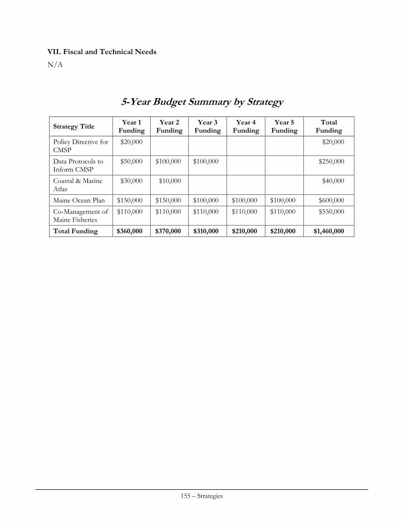
VII. Fiscal and Technical Needs
N/A
5-Year Budget Summary by Strategy
Year 1 Funding
Year 2 Funding
Year 3 Funding
Year 4 Funding
Year 5 Funding
Total Funding Strategy Title
$20,000 $20,000 Policy Directive for CMSP
$50,000 $100,000 $100,000 $250,000 Data Protocols to Inform CMSP
$30,000 $10,000 $40,000 Coastal & Marine Atlas
Maine Ocean Plan $150,000 $150,000 $100,000 $100,000 $100,000 $600,000
$110,000 $110,000 $110,000 $110,000 $110,000 $550,000 Co-Management of Maine Fisheries
Total Funding $360,000 $370,000 $310,000 $210,000 $210,000 $1,460,000
155 – Strategies
PUBLIC ACCESS
Maine has a fairly well developed infrastructure of public agency programs and private non-profit organizations in place and slowly making progress in securing, enhancing, and expanding public access to the Maine coast. Greater emphasis is needed on prioritizing access needs to tidal waters, with more attention given to coordination and collaboration across programs to yield greater results. These efforts will be bolstered by updated and new GIS based inventories and data bases, as well as a renewed analysis of access needs and prioritization of efforts.
Strategies to be funded by CZMA Section 306 monies
Create products and conduct studies that make the public aware of coastal water access issues and current opportunities to enhance and expand public access, and contribute to a change in recognized public trust rights in the intertidal zone. Strategy #1. Comprehensive Geographic Information System (GIS) Database MCP will partner with other agencies to develop a complete and up-to-date GIS layer of public access sites and conserved lands. One aspect of this database will be a water access data layer incorporating new inventory data being collected by the Island Institute, projects funded by LMF and other state and municipal efforts. An online and hard copy version of an access atlas will be developed. This strategy also supports the CZM Performance Measurement System by developing a means to quantify, characterize and track changes in the extent and type of public access points on the Maine coast. MCP will work with state agencies to identify existing data and data gaps, develop a format for this GIS application, and develop a process for regularly updating the data. Strategy #2. Public access program coordination in the Coastal Zone An SPO/MCP initiative to exert leadership and program coordination for recreational boating access programs in Maine’s coastal waters. There is an opportunity to take advantage of the state directive to the next administration to combine the state boating access programs (to achieve cost savings, enhance public investments and coordinate access site development and management) in a way that materially improves public access coordination.
156 – Strategies
Strategy #3. Coastal Water Access Needs Assessment and Prioritization With GIS data support, work with the Departments of Conservation and Inland Fisheries & Wildlife to update the State’s boating access program plan, including the results of a coastal access needs assessment and prioritization plan. Strategy #4. NEGC Land Conservation Initiative Participate in the NEGC Land Conservation Initiative as needed to represent New England coastal program interests and contribute to the regional demonstration project.
157 – Strategies

WETLANDS
Strategy #1: Development of a Standardized Tracking System for Wetland Loss, Restoration, and Conservation Actions
I. Issue Area(s)
The proposed strategy or implementation activities will support the following priority (high or medium) enhancement area(s) (check all that apply):
Aquaculture Cumulative and Secondary Impacts Energy & Government Facility Siting Wetlands Coastal Hazards Marine Debris Ocean/Great Lakes Resources Public Access Special Area Management Planning
II. Program Change Description
A. The proposed strategy will result in, or implement, the following type(s) of program changes (check all that apply):
A change to coastal zone boundaries; New or revised authorities, including statutes, regulations, enforceable policies,
administrative decisions, executive orders, and memoranda of agreement/understanding; New or revised local coastal programs and implementing ordinances; New or revised coastal land acquisition, management, and restoration programs; New or revised Special Area Management Plans (SAMP) or plans for Areas of Particular
Concern (APC) including enforceable policies and other necessary implementation mechanisms or criteria and procedures for designating and managing APCs; and
New or revised guidelines, procedures and policy documents which are formally adopted by a state or territory and provide specific interpretations of enforceable CZM program policies to applicants, local government and other agencies that will result in meaningful improvements in coastal resource management.
B. Program Changes(s) or Implementation Activities
The DEP, in conjunction with state and federal partners, has implemented an in-lieu fee compensation program which provides for compensation projects for wetland impacts statewide, including the coastal zone. This program substantially modified the existing wetland compensation program and has begun to demonstrate the creation of substantially higher quality compensation projects from those undertaken solely by a permittee. The development of a comprehensive tracking system for wetland loss and mitigation will allow for a review of the underlying compensation and mitigation ratios to ensure that there is not a net loss of wetland acreage statewide, including the coastal zone. This potential revision to the compensation and mitigation ratios would be the program change enacted by this enhancement.
158 – Strategies
III. Need(s) and Gap(s) Addressed
There is not currently an accurate tally of wetland loss, restoration, or conservation due to three principal factors – lack of data being collected in some instances, insufficient resolution of the data in order to distinguish data located within the coastal zone, and insufficient breakdown of information by wetland type and function to meet Section 309 requirements. One large data gap is the lack of information on the extent of wetland impacts that are less than 4,300 square feet in size as they are exempt from regulation. While some estimates can be made about the aggregate impact of these small wetland fills, to date none have been done systematically.
IV. Benefit(s) to Coastal Management
Better information will allow for better policy in regard to how to maintain no net loss of wetlands. It is difficult to manage coast, not to mention, state-wide policy on wetland loss when there is not sufficiently refined information.
V. Likelihood of Success
The underlying work to implement this strategy is straightforward and technical with regard to tracking systems and database changes. Implementation by end users will be ensured due to existing reporting requirements for wetland loss tracking.
VI. Strategy Work Plan
Total Years: 2 Total Budget: $22,000 Final Outcome(s) and Products: Revised wetland loss and compensation tracking system for the DEP and LURC for coastal wetlands. Year: 1 Description of activities:
Convene agency working group of representatives of SPO, DEP, and LURC. Refine list of specific wetland impacts, conservation and restoration metrics to be tracked by
each Agency. Identify and compare existing tracking procedures and database systems at DEP and LURC. Identify needed changes in procedures at both agencies in order to track needed data. Identify how the coastal zone definition is to be used as a screening filter to extract that
wetland data needed just for 309 Assessment that is otherwise to be collected on a statewide basis.
Identify all needed database changes at both agencies and complete all needed software coding and system development.
For exempt wetland impacts not tracked by permitting decisions, develop a methodology to use existing remote sensing imagery and an appropriately designed statistical sample of plots in both LURC and DEP jurisdiction that will allow for a representative calculation of the amount of exempt wetland fill.
Outcome(s): Unified tracking and reporting system.
159 – Strategies
Budget: $15,500 (AmeriCorp staffer PS & AO expenses) $6,500 (Computer programming support, Maine OIT)
DEP expects to contribute .10 FTE of a GIS Coordinator toward this project to assist in development analysis tools for exempt wetland fill.
Year: 2 Description of activities:
Convene interagency group to evaluate 5 year trends in wetland loss and data collected on exempt fill.
Evaluate trend data and determine how current compensation & mitigation ratios work to meet no net loss.
Develop recommendations for DEP consideration Draft revisions to rules as needed to amend ratios Conduct rulemaking
VII. Fiscal and Technical Needs A. Fiscal Needs:
There will be staff support provided from several state agencies to complete this project. B. Technical Needs:
This project will engage the necessary expertise represented by multiple state agencies. Strategy #2: Developing & Implementing Goals to Guide Restoration and Land Conservation Investments for Maine’s Coastal Habitats
I. Issue Area(s)
The proposed strategy or implementation activities will support the following priority (high or medium) enhancement area(s) (check all that apply):
Aquaculture Cumulative and Secondary Impacts Energy & Government Facility Siting Wetlands Coastal Hazards Marine Debris Ocean/Great Lakes Resources Public Access Special Area Management Planning
II. Program Change Description
A. The proposed strategy will result in, or implement, the following type(s) of program changes (check all that apply):
A change to coastal zone boundaries; New or revised authorities, including statutes, regulations, enforceable policies,
administrative decisions, executive orders, and memoranda of agreement/understanding; New or revised local coastal programs and implementing ordinances; New or revised coastal land acquisition, management, and restoration programs;
160 – Strategies
New or revised Special Area Management Plans (SAMP) or plans for Areas of Particular Concern (APC) including enforceable policies and other necessary implementation mechanisms or criteria and procedures for designating and managing APCs; and
New or revised guidelines, procedures and policy documents which are formally adopted by a state or territory and provide specific interpretations of enforceable CZM program policies to applicants, local government and other agencies that will result in meaningful improvements in coastal resource management.
B. Program Changes(s) or Implementation Activities
Creation of a new Maine Habitat Restoration Program that has, as its foundation, a comprehensive, in-depth, watershed-based prioritization. Adoption of the prioritization plan by existing funding programs (such as Maine’s in-lieu fee program) via memoranda of understanding between state agencies and between state and federal agencies, and development of one or more new funding sources.
III. Need(s) and Gap(s) Addressed
There is currently no program dedicated to coordinating the many disparate efforts by government agencies and other organizations engaged in restoration and conservation of habitats or natural community types in Maine. Lacking a state program devoted to coordinating, tracking progress, or developing guidelines for restoration and conservation, fundamental strategic needs have gone unaddressed. Principal among these are the need to determine a successful rate or total amount of restoration/conservation sought for natural community or habitat types of relevance. Lacking these benchmarks of success, there are few if any measures by which to credibly assess our progress toward preserving those ecosystem elements that remain functional and rehabilitating those that do not. Current restoration programs struggle to find matching dollars and Maine’s ability to compete for restoration dollars is hampered by lack of a state source of matching funds.
IV. Benefit(s) to Coastal Management
One intent and anticipated outcome of developing restoration and conservation goals will be to provide the basis for a strategic approach. The needs assessment that will inform the identification of goals will infuse restoration and conservation in Maine with efficiency and efficacy by directing limited investments when and where they are likely to address the most urgent priorities. The actual development of goals that follows the needs assessment will provide measures of success for ongoing investments and contribute to the coastal management performance measurement system. Maine’s advantage in competitive grant programs will be increased given this new strategic focus and aided by a state source of matching funds.
V. Likelihood of Success
The likelihood of success for identification of restoration and conservation needs and goals is high, given that this is an area that is widely recognized as warranting attention. Periodic convening of a technical and policy group will be required to evaluate progress toward established goals and update goals, but interest in pursuing objectives of this project is already high. However, our ability to establish a new funding source for restoration will be a challenge given current economic conditions but an approach that focuses on cost savings to the state and towns (i.e. restoring ecosystem
161 – Strategies
functions and reducing infrastructure maintenance costs) and the enhancement of a “green jobs” sector may prove successful.
VI. Strategy Work Plan
Total Years: 4 Total Budget: $343,700 Final Outcome(s) and Products: Regionally or watershed-defined, integrative coastal habitat recovery and conservation goals for the state of Maine. This new policy approach will be summarized in a report that provides the ecological basis for assessed needs, the rational for identified goals based on needs and other factors, and the list of goals by natural community/habitat type or broader category where that approach is warranted. Where appropriate, goals will identify differing rates of restoration (for some natural communities the level of urgency is higher than others) and measures indicating the total amount of recovery sought. Parameters types for goals are likely to include some combination of areal and linear habitat measurements and also ecological end-points, such as the following examples:
areal (e.g. acres of salt marsh area with re-established flow) areal (e.g. acres of low-lying topography to accommodate transgression of intertidal systems
resulting from sea level rise) linear (e.g. miles of stream with re-established access for diadromous fish) acres or miles for each of the above/year (for rate of progress) abundance of diadromous fish of a given species using a given drainage
The recommendations will include sample MOUs for formalization of the new policy approach and recommendations for implementation funding. Year(s): 1-2 Description of activities:
Convene a technical working group representing relevant areas of restoration and conservation expertise
Develop a conceptual approach for assessing need to the extent possible, based on examples of efforts outside of Maine
Use the working group to refine/revise the needs assessment approach
Develop a workplan for the needs assessment and identification of goals Perform and document results of the needs assessment Identify goals based on the needs assessment and other relevant factors Identify current and future funding requirements and develop capacity-building approaches Draft a final, fully-vetted report documenting relevant phases of the project providing the
watershed, regional and statewide restoration goals for habitat or natural community types and recommendations for funding
Adoption the report as state policy, development and execution of MOUs and creation of implementation plan
162 – Strategies
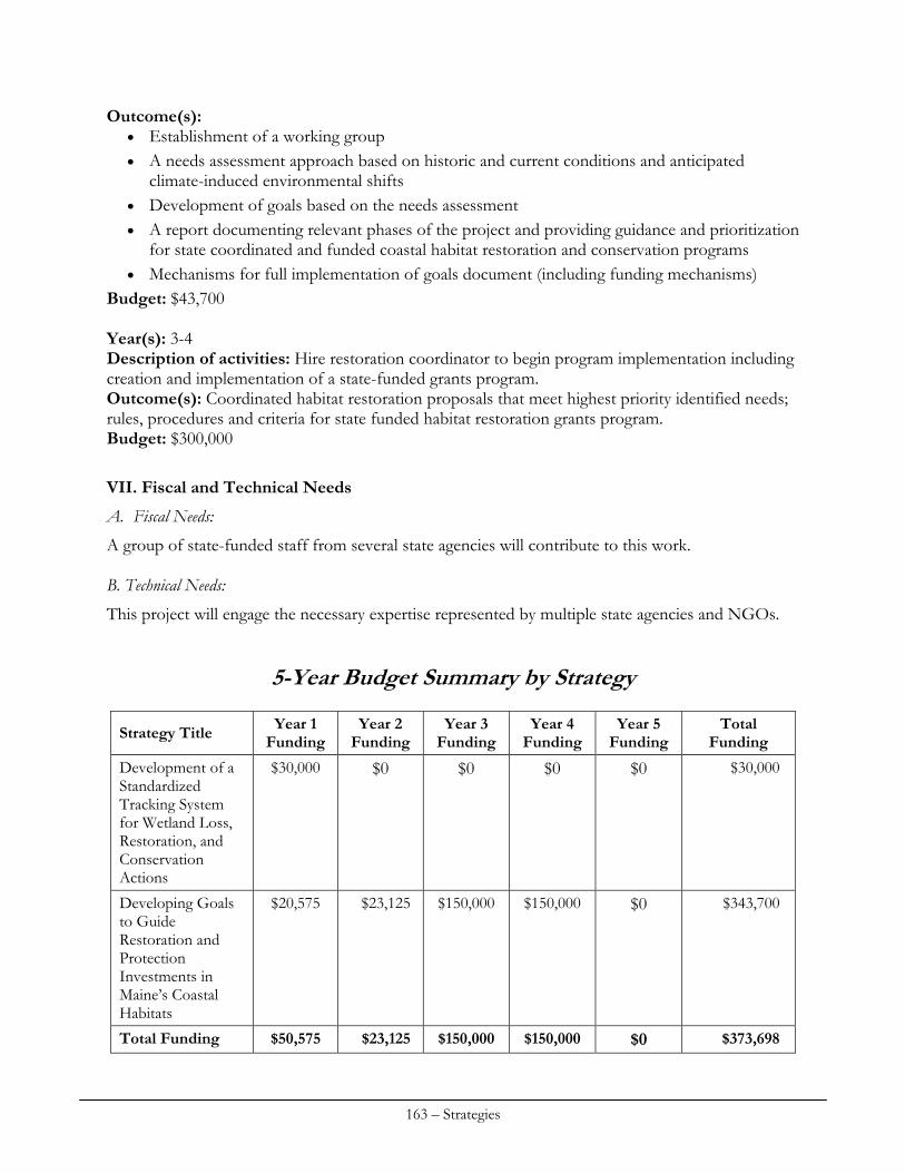
Outcome(s): Establishment of a working group A needs assessment approach based on historic and current conditions and anticipated
climate-induced environmental shifts Development of goals based on the needs assessment A report documenting relevant phases of the project and providing guidance and prioritization
for state coordinated and funded coastal habitat restoration and conservation programs Mechanisms for full implementation of goals document (including funding mechanisms)
Budget: $43,700 Year(s): 3-4 Description of activities: Hire restoration coordinator to begin program implementation including creation and implementation of a state-funded grants program. Outcome(s): Coordinated habitat restoration proposals that meet highest priority identified needs; rules, procedures and criteria for state funded habitat restoration grants program. Budget: $300,000
VII. Fiscal and Technical Needs
A. Fiscal Needs:
A group of state-funded staff from several state agencies will contribute to this work. B. Technical Needs:
This project will engage the necessary expertise represented by multiple state agencies and NGOs.
5-Year Budget Summary by Strategy
Year 1 Funding
Year 2 Funding
Year 3 Funding
Year 4 Funding
Year 5 Funding
Total Funding Strategy Title
$30,000 $0 $0 $0 $0 $30,000 Development of a Standardized Tracking System for Wetland Loss, Restoration, and Conservation Actions
$20,575 $23,125 $150,000 $150,000 $0 $343,700 Developing Goals to Guide Restoration and Protection Investments in Maine’s Coastal Habitats
Total Funding $50,575 $23,125 $150,000 $150,000 $0 $373,698
163 – Strategies

164 – Strategies
Appendix
Public Comments & MCP Staff Responses


Maine Coastal Program staff appreciate the thoughtful comments provided on the draft version of this document. All comments helped us to revise the document. Thanks to all readers who helped us improve and clarify our approaches. We welcome additional thoughts and involvement as we work to implement this strategy.
* * * * * * * * * * * * * * * * W. Donald Hudson, Jr., Ph.D. I’ve read through the very interesting draft assessment of the Maine Coastal Program, and I must say that it is a very thorough presentation. The many issues (and opportunities!) facing us along the coast and in the near ocean appear a bit daunting when seen altogether. However, I believe that the presentation and relative ranking of such things as Public Access, Coastal Hazards, Ocean Resources, Cumulative and Secondary Impacts, Special Area Management Planning, Wetlands, Aquaculture, Energy and Government Facility Siting, and Marine Debris is complete and fair. In particular, an issue like public access is not something addressed in a vacuum. It requires community and individual ‘buy-in’ and a genuine understanding of need in order to surface genuine opportunities for action. Energy and government facility siting related to renewable energy – wind and tidal, primarily – in the coastal zone (and near ocean) has clearly moved to the front burner in Maine and the region. I sometimes worry that such big issues that present immediate and pressing need for response put a drain on overall effort. There are only 24 hours in a day! The sort of planning represented by this Draft Assessment and Strategy will go a long way in helping you folks in the Maine State Planning Office to keep a handle on all priorities. Warm regards, Don Maine Coastal Program staff response: MCP agrees with Mr. Hudson’s observation about the need for public involvement in the area of public access. Community and landowner outreach is consistently employed in MCP’s public access programming.
* * * * * * * * * * * * * * * * Robert Foley Save Our Shores-Maine I wish to submit the following comments regarding the Maine Coastal Program 2010 Draft Assessment and Strategy: My comments refer to the Coastal Hazard Sections of the report. Please accept these comments as constructive attempts to improve our Maine Coastal Strategies for which I am very passionate. I mean no disrespect in any criticisms put forth.
First, it is disappointing to see that all the strategies and proposed action plans going forward do not include a Stake Holders Group process, which worked so well to formulate many of the proposals cited in the Assessment. Any changes to the CSDR should involve this group in order to maintain landowner support and the relationships of trust that the process built between the diverse groups. I see Section 5 (E)(1), Seawall Provisions, is being considered for changes by DEP and MGS. This particular area was very divisive in the reworking of the 2006 version of the CSDR and requires property owner group involvement in any discussions if support for changes are to be accepted. There are other sections of the 2006 CSDR that require review and modification from our standpoint. I would suggest a comprehensive review by the stakeholders group to further clarify or modify other sections, such as the maintenance and repair provisions, beach nourishment section, and other areas that groups, outside of the state agency review process, may want reviewed. The second area of concern is that there is no strategy to address the lack of support by landowners and municipal officials for the state’s sea level rise initiatives. There continues to be a healthy skepticism by many outside of the state agency force for these proposals. I think failure to include similar stakeholders task force group processes that were used in the development of the 2006 CSDR, Piping Plover Management Agreements and the State of Beaches Report helped foster support or buy in by the folks most impacted. Strategies going forward will be difficult to implement while this skepticism remains. The recent withdrawal of the FEMA flood remapping for coastal southern Maine hasn’t helped the overall low confidence in the governmental process. Involving stakeholders and listening to their concerns and input is essential if you want support for these strategies going forward. Finally, it is disappointing to see that none of the initiatives recommended by the Beach Task Force that developed the State of Maine Beaches Report and Policy have been initiated. While economic times have been restrictive, nothing has been done to even initiate any of the simple steps recommended to improve Maine’s beaches. A proposal to nourish Wells and Drakes Island Beaches, in conjunction with a dredge of a nearby harbor, has languished in bureaucratic red tape for over three years, with the local community spending over $100,000 in permitting costs to date. If we indeed want to improve our coastal habitats, we need a better, more supportive process than that which has been evidenced thus far in this process. It seems that all the state and federal review agencies are content with the lack of process. All of the MOA’s and Beach Management strategies have been pushed aside and gridlock has replaced common sense. We need a better process than this if we are to improve our beaches. All the reports in the world, sitting on various shelves, haven’t accomplished a thing; action plans and real implementation proposals are required. Thanks you for allowing me to comment. Respectfully submitted, Robert Foley Save Our Shores-Maine Maine Coastal Program staff response: Mr. Foley correctly pointed out that collaborative work with coastal stakeholders (landowners and municipal officials) is key towards improving Maine’s regulatory (and non-regulatory) approaches to conservation of Maine’s beach communities. MCP staff agrees that the success of each of the coastal hazards strategies contained in the Plan is dependent on early and steady communication and
active involvement by coastal stakeholders. We have added references to stakeholder engagement in the Hazards strategy section. The introduction to the hazards strategy section explains our intent to involve stakeholders in any future efforts. Mr. Foley also noted the limited implementation of the recommendations of the 309-funded Improving Maine’s Beaches report. Implementation of the recommendations largely depends on new funding. MCP has on two occasions developed bond proposals to fund beach restoration that have not been forwarded to the Legislature by the current Administration. MCP provides updates to the Joint Standing Committee on Natural Resources about the Improving report, which includes a State of Maine’s Beaches report, co-sponsors a semi-annual conference for homeowners and town officials, completed an economic analysis of the value of Maine’s beaches, and invests in ongoing mapping and data collection by the Maine Geological Survey. A meeting of the group named to oversee implementation of the report will be held in 2011. Regarding beach nourishment and dredging – state agencies continue to place a priority on beneficial use of dredge material on beaches. The Maine DOT also submits an annual dredging priorities ranking to the Army Corps of Engineers and the Maine Congressional delegation.
* * * * * * * * * * * * * * * * John Ferland Ocean Renewable Power Company The document reflects a lot of good work. Congratulations! I’m not sure if these comments are what you’re looking for, but I thought I’d pass on a few thoughts for you and your team: Page 40: A small nit: The pipeline to Montreal is a crude oil pipeline, not to be confused with the heating oil pipeline heading. Page 43: You might consider mentioning the special training/education facility designation that FERC has provided to the Tidal Energy Device Evaluation Center at Maine Maritime Academy (a good story about it in a recent Bangor Daily News). Pages 45-48: In this section you may want to reference the tidal energy MOUs between the State of Maine and FERC and the State of Maine and the Province of Nova Scotia. These illustrate strong and high level policy support for renewable development within the coastal zone and how state leadership is reaching out to other jurisdictions to inspire collaboration, both at the federal/state level and at an international cross border level. You might also cite that because Maine has been clear about its renewable energy preferences in the coastal zone, much collaboration has occurred to enable a high level of US DOE funding support for both tidal and offshore wind projects in Maine. Additionally, the EDA has provided nearly $1.5 million to a partnership that includes Washington County and the City of Eastport to support creation of a marine energy manufacturing center that would support development of a Maine ocean energy manufacturing supply chain. Thanks for the opportunity to comment and good luck putting together the final report. Regards, John
Maine Coastal Program staff response: Suggested additions and corrections provided by ORPC were incorporated into the assessment portion of the Energy and Government Facilities Siting section of the Plan.
* * * * * * * * * * * * * * * * Susan Olcott Ocean Conservancy Thank you for the opportunity to comment on the Maine Coastal Program’s 2010 Draft Assessment and Strategy. In general, it is our opinion that the prioritization of the nine areas to be addressed is accurate and reflects the areas of highest urgency for coastal planning in Maine. We would like to comment on a few specific assessments, the strategies proposed to address the problems identified, and to suggest some potential partnerships to maximize the effectiveness of these strategies. We understand that marine debris is not a high priority at the moment, given other more pressing coastal issues, but we would still like to stress the importance of this issue, particularly the impact of derelict gear. We are pleased to see that the state has placed a high priority on seafloor mapping to identify areas of high concentrations of such gear. However, the complicated regulatory framework that currently exists prevents coastal clean-up groups, which have the volunteer manpower to remove and dispose of this gear, from doing so. We suggest continuing to improve the system used to permit gear removal in order to facilitate its cleanup through partnerships with organizations who conduct coastal clean-ups. We are pleased to see that one of the needs identified for aquaculture is to improve environmental assessment techniques. Specifically, we support the review of current benthic discharge limits for finfish operations and the assessment of impacts of shellfish culture on sensitive habitats such as eelgrass beds. Energy siting that balances responsible development with adequate habitat protections and avoids undue user conflicts is a pressing issue in Maine. We are pleased to see the state’s recognition of coastal and marine spatial planning as an important tool which can be used to achieve these goals, and one that has already been utilized to identify wind energy test sites in the state. We are supportive of the development of the Coastal Atlas as a planning tool and as a means of consolidate existing data and identifying existing data gaps. We suggest coordination across state and international boundary lines in development of this tool in order to standardize, to the greatest extent possible, the way data are presented and formatted, and also to utilize data sets that cross jurisdictional boundaries. We support the formation of Biological Advisory Councils to assess natural resource impacts from offshore renewable development and to identify incompatible human and ecological uses. Finally, we support the prioritization of stakeholder outreach in the process in order to craft a viable plan that is both economically and ecologically sustainable and also the improvement in the existing governance framework for offshore wind energy through well-coordinated state-federal environmental review.
Special Area Management Planning is another important tool for coastal planning. We are pleased to see that the Taunton Bay pilot project will be finishing this year and look forward to its assessment and review. As mentioned above, we are also supportive of the state’s efforts to compile and map existing data through the Coastal Atlas and to expand this data set through projects such as sonar mapping of benthic habitats. Finally, we are optimistic that, through the establishment of the National Ocean Council and a framework for national coastal and marine spatial planning, many of these issues can be addressed not just on a state level, but in coordination with regional ocean councils and with federal support. Thank you for taking the time to review these comments and we will look forward to continuing to work with you on coastal planning issues. Please feel free to contact me with further questions or if I can be of help in providing any useful resources. Sincerely, Susan Little Olcott Maine Coastal Program staff response: MCP plans to continue partnering with the Department of Marine Resources (policy staff, scientists and Marine Patrol) and non-governmental organizations on the collection, recycling and disposal of derelict fishing gear.
* * * * * * * * * * * * * * * * Kermit Smyth Brunswick Conservation Commission The Maine coastline is renowned worldwide for its natural beauty and its healthy plant and animal communities. Such areas are biologically diverse and are also resilient in the face of coming changes, whether these be man-made or environmental in nature – for example, effects due to climate change. Today the biodiversity of natural areas faces two primary threats: (1) human development, such as new housing and roads, and (2) invasive plants. The Maine Coastal Plan addresses the first threat on multiple fronts but is woefully inadequate in recognizing the devastation to marsh and wetland communities posed by invasive plants. Phragmites australis In recent years The Nature Conservancy of Maine has tracked three invasive species along local waterways – Purple Loosestrife, Japanese Knotweed, and Phragmites. Of these, Phragmites poses the largest threat by far. Extensive stands have appeared in recent decades in Maine, such as in Scarborough Marsh, coastal areas near Gisland Farm in Falmouth, and in the New Meadows embayment. Exotic Phragmites was likely introduced to America ca. 1800 via trans-Atlantic shipping from Europe using soil as ballast - just as purple loosestrife arrived. This soil was dumped in coastal marshes near the major northeastern port cities. Phragmites expansion appears to have accelerated in the last thirty years. Large, monocultural stands of invasive Phragmites have a striking impact upon wetland communities. Plant biodiversity is sharply reduced due to shading and reduced
germination rates. In many instances Phragmites chokes out all other vegetation and thus reduces the value of wetland habitat to most wildlife. Invasive phragmites can affect the nitrogen cycle, alter sedimentation rates, limit the exchange of energy between trophic levels, and may lower the water table due to high transpiration rates. Along the North Atlantic coastline Phragmites has become the signature of wetland alteration, i.e., the symbol of “biological pollution. Maine Coastal Plan “Invasive species” are mentioned only twice in this draft plan (pp. 35 and 80). I examined three of the nine sections where controlling invasives, especially Phragmites, would seem to be most relevant, i.e., Cumulative and Secondary Impacts (pp.34-39 and 116-124). One of the Priority Needs identified on p. 39 is “Coastal habitat maps”, and Strategy #2 (pp. 118-122) involves updating Maine Geological Survey maps from 1960’s aerial photography. These updates should include the mapping of Phragmites stands, which will undoubtedly show the rapid expansion of this invasive. Indeed, such aerial surveys have documented aggressive Phragmites expansion in the New Meadows “lake”. Special Area Management (pp. 74-77). Goals include the protection of natural resources and critical habitats, yet Maine has designated no Special Management Areas! Stands of invasive Phragmites should be so designated - for removal as quickly as possible. Wetlands (pp. 75-85 and 150-155). Exotic species is listed as a high-impact threat, extensive, and moderate-to-highly irreversible on p. 80. Phragmites is specifically mentioned. Strategies (pp. 150-155) include (1) Develop tracking system for wetland loss, restoration, and conservation, and (2) Develop goals to guide restoration and land conservation. Tracking and removing invasive plants should clearly be included here. Maine Coastal Program staff response: MCP staff acknowledges the threats posed to Maine’s coastal wetlands by invasive species, as stated in the Wetlands and Cumulative Impacts assessment chapters. No initiatives related to invasive plants are included in the strategies section of the document because such efforts are not eligible as “program changes” under CZMA Section 309 (i.e. development and implementation of “enforceable policies”). Past examples of MCP’s work in the area of invasive plants includes previous grants to the Friends of the Scarborough Marsh, staff support provided to the New Meadows estuary effort, staff support provided to the Gulf of Maine Restoration Plan effort and staff support provided to two working groups on invasive species. Any future assessments of Maine’s coastal wetlands will assuredly note the status of invasive plants and restoration strategies will also note opportunities for control of invasives.