Embed Size (px)
Citation preview
Filiz Özdem (İstanbul, 1965) After graduating from the Italian High School she studied philosophy at Istanbul University and went on to take a master’s degree in the same department. Her translations, poems, articles and essays on art have been published in a number of magazines and newspapers, and her essays have been included in several anthologies. She translated the works of Pier Paolo Pasolini, Luigi Malerba, Carlo Collodi, Edmondo de Amicis, Italo Calvino, Gianni Rodari and Lucia Tumiati. She has written numerous catalogue texts for exhibitions at Maltepe Art Gallery, Milli Reasürans Art Gallery, Sevimce Art Gallery and Artisan Art Gallery. She has also prepared monographies of several Turkish cities for Yapı Kredi Publications: Uygarlıklar Kapısı Urfa (2002), Bitek Kent: Balıkesir (2003), Sırtı Dağ, Yüzü Deniz: Mersin (2004), Taşın Belleği: Mardin (2005), Kars: “Beyaz, Uykusuz, Uzakta” (2006), Karaların ve Denizlerin Sultanı İstanbul (2009), Dağların Gazeli Maraş (2010), Denizli: Tanrıların Kutsadığı Vadi (2011) and Aşklar, Savaşlar, Kahramanlar ve Çanakkale [City of Legends and Epics: Çanakkale] (2012); Erciyes’in Rüyası: Kayseri [City of the Caesars: Kayseri] (2013).
Publications: Saydam ve Seyirci (poems), Maltepe Art Gallery, 1999; Korku Benim Sahibim (novel), Yapı Kredi Publications, 2007; Düş Hırkası (novel), Yapı Kredi Publications, 2009; Yalan Sureleri (novel), Yapı Kredi Publications, 2010; Rüya Bekleyen Adam (novel), Yapı Kredi Publications, 2013. Beside her novels she is one of the prominent writers in children literature.
Ali Konyalı (Istanbul, b. 1960) studied graphic art at Mimar Sinan University and began working as a professional photographer during the same period. He produced multivision shows for the 1985 Anatolian Civilisations exhibition, and these were followed by audiovisual presentations, books and other publications. In 1993 he went to the USA, where alongside his studies he organised pho-tography exhibitions about Turkey as well. Since he returned to Turkey in 1999 he has been working on documentary photography projects in the field of culture and art for exhibitions, books and multivision.
Books illustrated by Ali Konyalı: Topkapı Sarayı, Akbank; Türk İslam Eserleri Museum, Akbank; İstanbul Arkeoloji Museum, Akbank; Martıların İstanbul’u, Türkiye İş Bank; Mavi Uygarlık, Türkiye İş Bank; Kubad Abad Sarayı ve Çinileri, Türkiye İş Bank; Hasankeyf, Tür-kiye İş Bank; Menderes’in Surlarında “Didim-Milet-Priene”, Yaşar Holding; Doğu Karadeniz’de Kırsal Mimari, Milli Reasürans; İstanbul Topografyaları, Zeytinburnu, Istanbul Metropolitan Municipality; Antik Çağ Anadolu Takıları, Akbank; Bulutların Altındaki Uygarlık An-adolu, Türkiye İş Bank; Bellek ve Ölçek – Modern Türk Heykelinin 15 Sanatçısı, İstanbul Modern; Soyut Boyut, Türkiye İş Bank; İmoga – İstanbul Grafik Sanatlar Museum, Beşiktaş Municipality; Cumhuriyet’in İlk Ressamları, Türkiye İş Bank; Bin Çeşit İstanbul ve Boğaziçi Yalıları, Ak Yayınları; Çağdaşlar, Türkiye İş Bank; Rahmi Koç Endüstri Museum, YKY; EU. Museum With No Frontiers, Virtual Museum; EU. Discover İslamic Art, Virtual Museum; Türk Seramik Sanatı, Mimar Sinan University of Fine Arts; Kent Belleği, Mekânsal Süreklilikler-İstanbul, Istan-bul Metropolitan Municipality; Türkan Şoray Beyazperdeden Kostümler, Turkish Ministry of Foreign Affairs; Bir İmparatorluk İki Saray, YKY; İstanbul Experience, Istanbul Metropolitan Municipality; İstanbul Uygarlıklar Beşiği, Istanbul Metropolitan Municipality; Gravür-lerle İstanbul, Istanbul Chamber of Trade; Anadolu’da Farklı Kültürlerde Güzeli Arayış, HSBC Bank; Kuzeydoğu Anadolu’da Mimari, Milli Reasürans Art Gallery; Labranda, Milli Reasürans Art Gallery; Denizli: Tanrıların Kutsadığı Vadi, YKY; Lâle: Doğada, Tarihte, Sanatta, YKY.
Photography Exhibitions: “Two Cultures One Story”, Hagia Eirene Museum; “Hidden Treasures”, Museum of Turkish and Islamic Art; “Sorrowful Icons”, Museum of Turkish and Islamic Art; “Heritage of Cultures Traced in Walls and Water”, Beykent University; “Alien – Diary of a Stranger”, Maçka Art Gallery; “Rural Architecture in Turkey’s Eastern Black Sea Region”, Milli Reasürans Art Gal-lery, Istanbul - Bilge Akın Art Gallery, Bodrum - Tarık Akıltopu Art Gallery, Antalya – Sarajevo Turkish Cultural Centre, Bosnia and Herzegovina - Ljubljana University Faculty of Architecture and Ljubljana Architecture Museum, Ljubljana, Slovenia - ARCI Gallery, Tif lis, Georgia - Batum Art Museum, Georgia - Kars Art Gallery, Kars – Karadeniz Technical University Faculty of Architecture Art Gallery, Trabzon - Lendava Castle, Slovenia - Diyarbakır Art Centre, Diyarbakır - İzmir State Museum of Fine Arts, İzmir - Kızıltepe Cultural and Art Centre, Mardin - Pirnat Art Gallery, Slovenia - Helsinki Museum of Finnish Architecture, Finlandiya - Medelhavs Museum, Stockholm, Sweden - Copenhagen Royal Academy of Contemporary Art and Architecture, Denmark; “Taş ve Işık”, Istan-bul Archaeological Museum; “İstanbul Ports”, Venice Architecture Biennale, Palermo; “Hinter Den Stadtmauern Von İstanbul” - Berlin, KunstBureau Berlin EU; “Colour of Women”, Macedonian Cultural Centre, Istanbul; “Türkan Şoray’s Costumes for the Silver Screen”, Ankara Palas; “Architecture of Northeastern Turkey”, Milli Reasürans Art Gallery.
Tarkan Kutlu (1971, Sivas) graduated from Istanbul University, Department of Tourism Business Management and in 2001 he began to work as an assistant photographer. He worked together with Ali Konyalı on many cultural and artistic projects including rural architecture in the eastern Black Sea, northeast Anatolia, Milas and Labranda as well as producing YKY’s Istanbul and Denizli monographs. At present he is working on his own projects which include portraits of children in Anatolia and architectural decora-tive details.
Merete Çakmak (Copenhagen, 1953) has worked as a freelance translator for the past 15 years. She has translated various magazines including Skylife, Istanbul City Magazine and Jetlife as well as exhibition catalogues for Dolmabahçe Palace and Topkapı Palace among others. She has also translated numerous articles mainly on history, art history, culture and culinary culture. She has translated Turkish fiction into English and Danish and books from German into English and Turkish. She has compiled and published a Turkish-English dictionary of bird names.
AmasyaMaid of the Mountains

EditorFiliz Özdem
PhotographsAli Konyalı - Tarkan Kutlu
TranslationMerete Çakmak
AmasyaMaid of the Mountains
Filiz Özdem • Amasya, Maid of the Mountains • 7
Şevket Dönmez • The Ancient City of Amaseia • 9
E. Emine Naza Dönmez • Amasya Harşena Castle and Kızlar Sarayı Excavations • 29
Şevket Dönmez - Aslıhan Yurtsever Beyazıt • Oluz Höyük: A Multicultural Settlement in
Pontic Cappadocia • 51
Muzaffer Doğanbaş • Past and Present Belief Systems and Sacred Architecture in Amasya • 73
E. Emine Naza Dönmez • The Development of Turkish Architecture in Amasya • 141
Muzaffer Doğanbaş • Wood Craft in Amasya • 201
İ. Hakkı Göztaş • Historical Development and Civil Architecture in Amasya • 249
Contents
Ya pı Kre di Ya yın la rı - 4267City Monographies - 26
Amasya, Maid of the Mountains
Editor: Filiz ÖzdemTranslation: Merete Çakmak
Photographs: Ali Konyalı - Tarkan Kutlu
Graphic design: Arzu Yaraş
Archives photographs:The Castle Excavation ArchiveOluz Höyük Excavation ArchiveMuzaffer Doğanbaş
Proofreading: Darmin Hadzibegovic
Print: Mas Matbaacılık San ve Tic. A.Ş. Hamidiye Mah. Soğuksu Cad. No: 3 Kağıthane-IstanbulPhone: (0 212) 294 10 00 e-mail: [email protected] Number: 12055
1st print: Istanbul, November 2014ISBN 978-975-08-3082-2
Responsibility for the essays in this book lies with the authors.
© Ya pı Kre di Kül tür Sa nat Ya yın cı lık Ti ca ret ve Sa na yi A.Ş., 2014Certificate Number: 12334All rights reserved.Apart from short extracts no part of this book may be reproducedin any form without written permission from the publishers.
Ya pı Kre di Kül tür Sa nat Ya yın cı lık Ti ca ret ve Sa na yi A.Ş.İstiklal Caddesi No: 142 Odakule İş Merkezi Kat: 3 Beyoğlu 34430 İstanbulPhone: (0 212) 252 47 00 (pbx) Fax: (0 212) 293 07 23http://www.ykykul tur.com.tre-mail: ykykul tur@ykykul tur.com.trInternet sales address: http://alisveris.yapikredi.com.tr
7
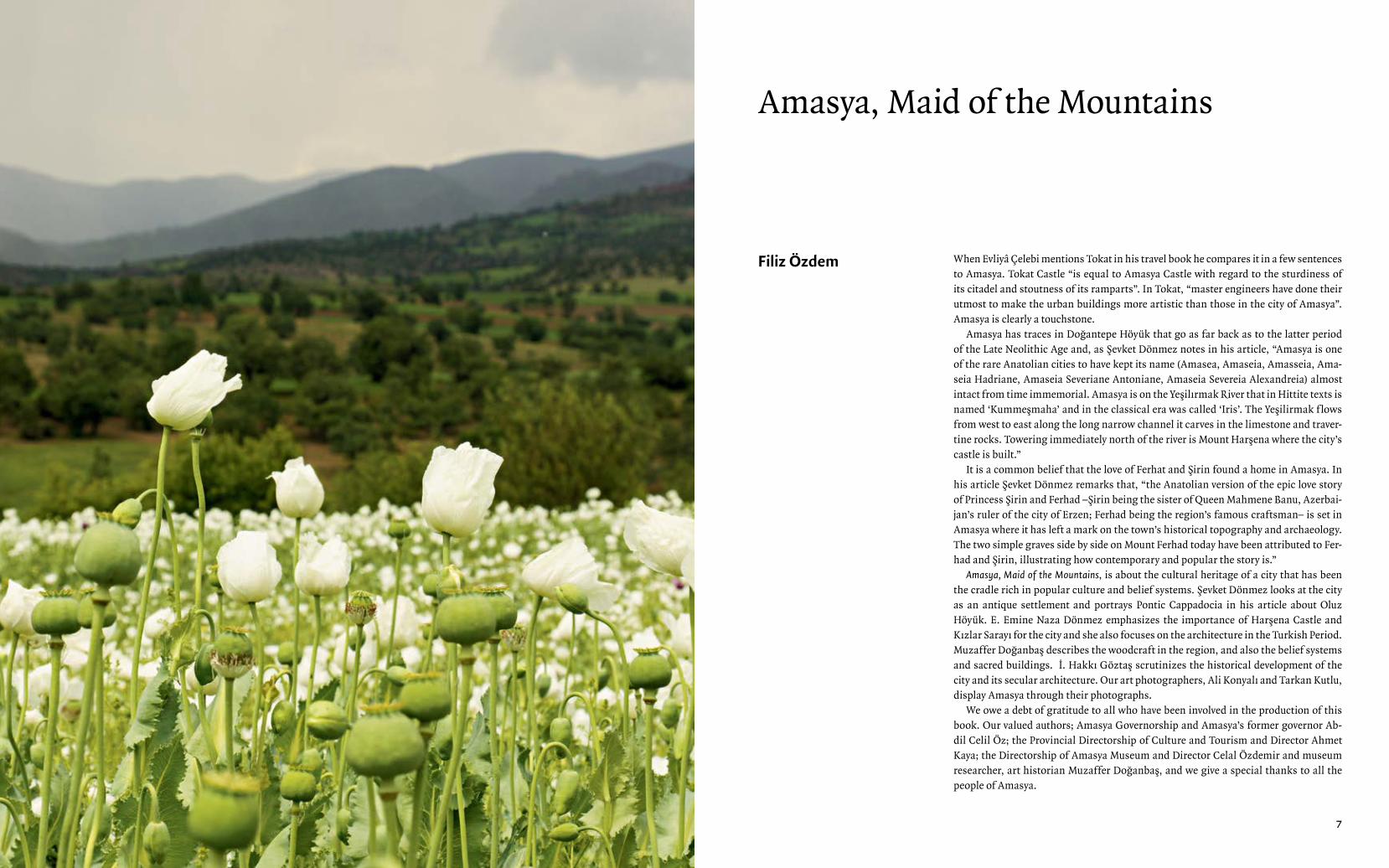
When Evliyâ Çelebi mentions Tokat in his travel book he compares it in a few sentences to Amasya. Tokat Castle “is equal to Amasya Castle with regard to the sturdiness of its citadel and stoutness of its ramparts”. In Tokat, “master engineers have done their utmost to make the urban buildings more artistic than those in the city of Amasya”. Amasya is clearly a touchstone.
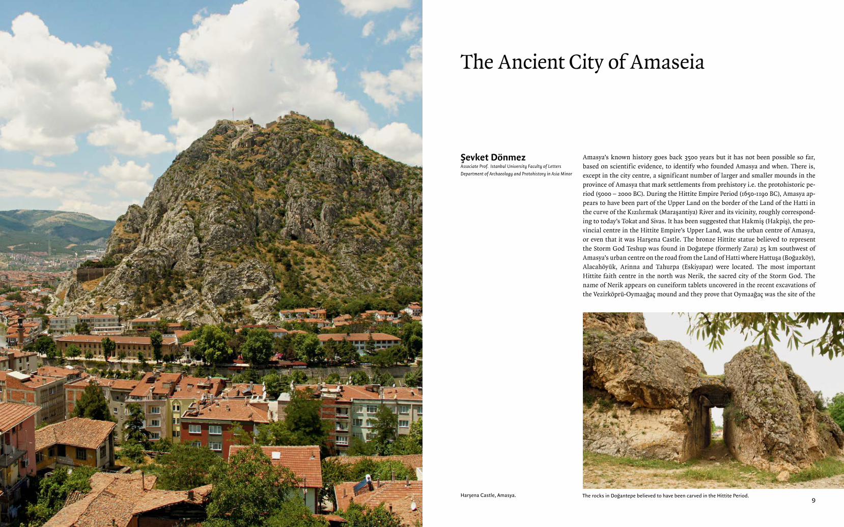
Amasya has traces in Doğantepe Höyük that go as far back as to the latter period of the Late Neolithic Age and, as Şevket Dönmez notes in his article, “Amasya is one of the rare Anatolian cities to have kept its name (Amasea, Amaseia, Amasseia, Ama-seia Hadriane, Amaseia Severiane Antoniane, Amaseia Severeia Alexandreia) almost intact from time immemorial. Amasya is on the Yeşilırmak River that in Hittite texts is named ‘Kummeşmaha’ and in the classical era was called ‘Iris’. The Yeşilirmak f lows from west to east along the long narrow channel it carves in the limestone and traver-tine rocks. Towering immediately north of the river is Mount Harşena where the city’s castle is built.”
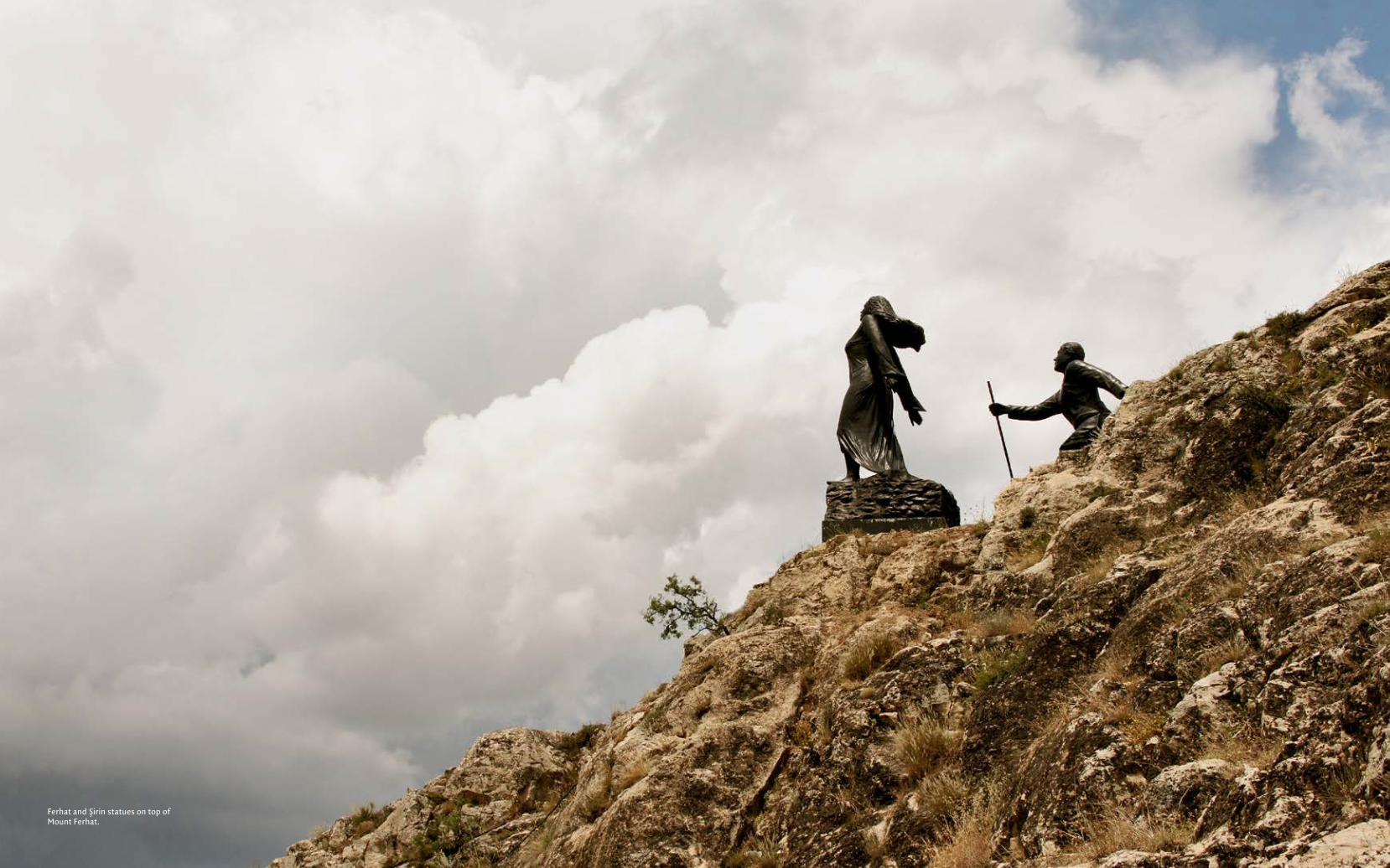
It is a common belief that the love of Ferhat and Şirin found a home in Amasya. In his article Şevket Dönmez remarks that, “the Anatolian version of the epic love story of Princess Şirin and Ferhad –Şirin being the sister of Queen Mahmene Banu, Azerbai-jan’s ruler of the city of Erzen; Ferhad being the region’s famous craftsman– is set in Amasya where it has left a mark on the town’s historical topography and archaeology. The two simple graves side by side on Mount Ferhad today have been attributed to Fer-had and Şirin, illustrating how contemporary and popular the story is.”
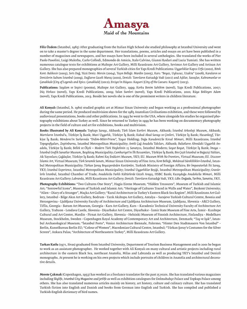
Amasya, Maid of the Mountains, is about the cultural heritage of a city that has been the cradle rich in popular culture and belief systems. Şevket Dönmez looks at the city as an antique settlement and portrays Pontic Cappadocia in his article about Oluz Höyük. E. Emine Naza Dönmez emphasizes the importance of Harşena Castle and Kızlar Sarayı for the city and she also focuses on the architecture in the Turkish Period. Muzaffer Doğanbaş describes the woodcraft in the region, and also the belief systems and sacred buildings. İ. Hakkı Göztaş scrutinizes the historical development of the city and its secular architecture. Our art photographers, Ali Konyalı and Tarkan Kutlu, display Amasya through their photographs.
We owe a debt of gratitude to all who have been involved in the production of this book. Our valued authors; Amasya Governorship and Amasya’s former governor Ab-dil Celil Öz; the Provincial Directorship of Culture and Tourism and Director Ahmet Kaya; the Directorship of Amasya Museum and Director Celal Özdemir and museum researcher, art historian Muzaffer Doğanbaş, and we give a special thanks to all the people of Amasya.
Amasya, Maid of the Mountains
Filiz Özdem
9
Amasya’s known history goes back 3500 years but it has not been possible so far, based on scientific evidence, to identify who founded Amasya and when. There is, except in the city centre, a significant number of larger and smaller mounds in the province of Amasya that mark settlements from prehistory i.e. the protohistoric pe-riod (5000 – 2000 BC). During the Hittite Empire Period (1650-1190 BC), Amasya ap-pears to have been part of the Upper Land on the border of the Land of the Hatti in the curve of the Kızılırmak (Maraşantiya) River and its vicinity, roughly correspond-ing to today’s Tokat and Sivas. It has been suggested that Hakmiş (Hakpiş), the pro-vincial centre in the Hittite Empire’s Upper Land, was the urban centre of Amasya, or even that it was Harşena Castle. The bronze Hittite statue believed to represent the Storm God Teshup was found in Doğatepe (formerly Zara) 25 km southwest of Amasya’s urban centre on the road from the Land of Hatti where Hattuşa (Boğazköy), Alacahöyük, Arinna and Tahurpa (Eskiyapar) were located. The most important Hittite faith centre in the north was Nerik, the sacred city of the Storm God. The name of Nerik appears on cuneiform tablets uncovered in the recent excavations of the Vezirköprü-Oymaağaç mound and they prove that Oymaağaç was the site of the
The Ancient City of Amaseia
Şevket DönmezAssociate Prof. Istanbul University Faculty of Letters
Department of Archaeology and Protohistory in Asia Minor
Harşena Castle, Amasya. The rocks in Doğantepe believed to have been carved in the Hittite Period.
Amasya, Maıd of the Mountaıns The Ancıent Cıt y of Ama seıa
11
sacred city. Nerik was captured by the tribal Kaskians, the en-emies of the Hittites on the Black Sea coast during the reign of King Hantili II (1490-1480 BC). The cult of the Storm God therefore had to be moved to Hakmiş in order to secure its perpetuation. The hypothesis that Hakmiş was Amasya’s predecessor has not been supported by any ruins or other re-mains of Hittite origin in the Harşena Castle. More impor-tantly, from a scientific point of view the theory is dubious because the topography of Mount Harşena does not conform to typical Hittite settlements. It is, however, highly likely that the Teshup statue relates to the Storm God that was moved from Nerik. The historical documentation and archaeologi-cal artefacts actually make the Doğantepe-Hakmiş connec-tion seem plausible.
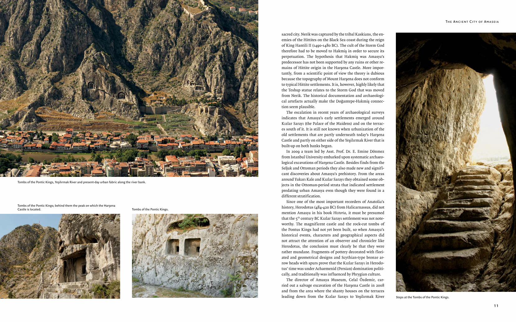
The escalation in recent years of archaeological surveys indicates that Amasya’s early settlements emerged around Kızlar Sarayı (the Palace of the Maidens) and on the terrac-es south of it. It is still not known when urbanization of the old settlements that are partly underneath today’s Harşena Castle and partly on either side of the Yeşilırmak River that is built-up on both banks began.
In 2009 a team led by Asst. Prof. Dr. E. Emine Dönmez from Istanbul University embarked upon systematic archaeo-logical excavations of Harşena Castle. Besides finds from the Seljuk and Ottoman periods they also made new and signifi-cant discoveries about Amasya’s prehistory. From the areas around Yukarı Kale and Kızlar Sarayı they obtained some ob-jects in the Ottoman-period strata that indicated settlement predating urban Amasya even though they were found in a different stratification.
Since one of the most important recorders of Anatolia’s history, Herodotus (484-420 BC) from Halicarnassus, did not mention Amasya in his book Historia, it must be presumed that the 5th century BC Kızlar Sarayı settlement was not note-worthy. The magnificent castle and the rock-cut tombs of the Pontus Kings had not yet been built, so when Amasya’s historical events, characters and geographical aspects did not attract the attention of an observer and chronicler like Herodotus, the conclusion must clearly be that they were rather mundane. Fragments of pottery decorated with f lori-ated and geometrical designs and Scythian-type bronze ar-row heads with spurs prove that the Kızlar Sarayı in Herodo-tus’ time was under Achaemenid (Persian) domination politi-cally, and traditionally was influenced by Phrygian culture.
The director of Amasya Museum, Celal Özdemir, car-ried out a salvage excavation of the Harşena Castle in 2008 and from the area where the shanty houses on the terraces leading down from the Kızlar Sarayı to Yeşilırmak River
Tombs of the Pontic Kings, Yeşilırmak River and present-day urban fabric along the river bank.
Tombs of the Pontic Kings; behind them the peak on which the Harşena Castle is located. Tombs of the Pontic Kings.
Steps at the Tombs of the Pontic Kings.
Amasya, Maıd of the Mountaıns The Ancıent Cıt y of Ama seıa
12 13Ferhat and Şirin statues on top of Mount Ferhat.
Amasya, Maıd of the Mountaıns The Ancıent Cıt y of Ama seıa
14 15
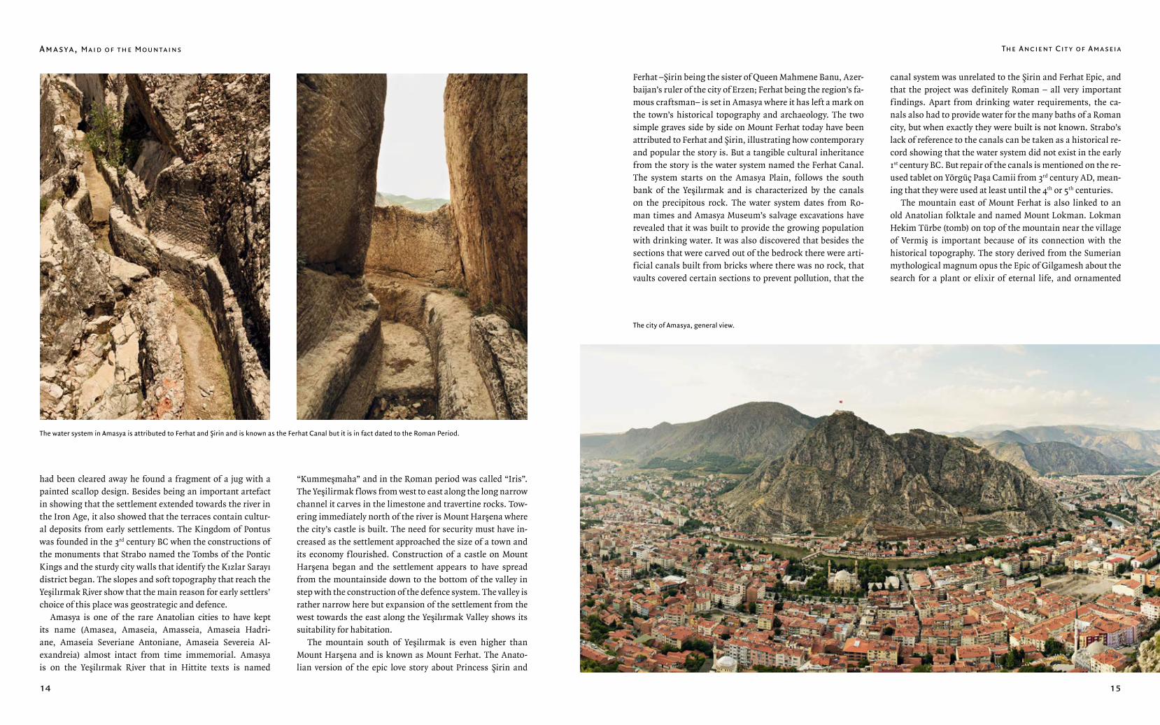
Ferhat –Şirin being the sister of Queen Mahmene Banu, Azer-baijan’s ruler of the city of Erzen; Ferhat being the region’s fa-mous craftsman– is set in Amasya where it has left a mark on the town’s historical topography and archaeology. The two simple graves side by side on Mount Ferhat today have been attributed to Ferhat and Şirin, illustrating how contemporary and popular the story is. But a tangible cultural inheritance from the story is the water system named the Ferhat Canal. The system starts on the Amasya Plain, follows the south bank of the Yeşilırmak and is characterized by the canals on the precipitous rock. The water system dates from Ro-man times and Amasya Museum’s salvage excavations have revealed that it was built to provide the growing population with drinking water. It was also discovered that besides the sections that were carved out of the bedrock there were arti-ficial canals built from bricks where there was no rock, that vaults covered certain sections to prevent pollution, that the
canal system was unrelated to the Şirin and Ferhat Epic, and that the project was definitely Roman – all very important findings. Apart from drinking water requirements, the ca-nals also had to provide water for the many baths of a Roman city, but when exactly they were built is not known. Strabo’s lack of reference to the canals can be taken as a historical re-cord showing that the water system did not exist in the early 1st century BC. But repair of the canals is mentioned on the re-used tablet on Yörgüç Paşa Camii from 3rd century AD, mean-ing that they were used at least until the 4th or 5th centuries.
The mountain east of Mount Ferhat is also linked to an old Anatolian folktale and named Mount Lokman. Lokman Hekim Türbe (tomb) on top of the mountain near the village of Vermiş is important because of its connection with the historical topography. The story derived from the Sumerian mythological magnum opus the Epic of Gilgamesh about the search for a plant or elixir of eternal life, and ornamented
had been cleared away he found a fragment of a jug with a painted scallop design. Besides being an important artefact in showing that the settlement extended towards the river in the Iron Age, it also showed that the terraces contain cultur-al deposits from early settlements. The Kingdom of Pontus was founded in the 3rd century BC when the constructions of the monuments that Strabo named the Tombs of the Pontic Kings and the sturdy city walls that identify the Kızlar Sarayı district began. The slopes and soft topography that reach the Yeşilırmak River show that the main reason for early settlers’ choice of this place was geostrategic and defence.
Amasya is one of the rare Anatolian cities to have kept its name (Amasea, Amaseia, Amasseia, Amaseia Hadri-ane, Amaseia Severiane Antoniane, Amaseia Severeia Al-exandreia) almost intact from time immemorial. Amasya is on the Yeşilırmak River that in Hittite texts is named
“Kummeşmaha” and in the Roman period was called “Iris”. The Yeşilirmak f lows from west to east along the long narrow channel it carves in the limestone and travertine rocks. Tow-ering immediately north of the river is Mount Harşena where the city’s castle is built. The need for security must have in-creased as the settlement approached the size of a town and its economy flourished. Construction of a castle on Mount Harşena began and the settlement appears to have spread from the mountainside down to the bottom of the valley in step with the construction of the defence system. The valley is rather narrow here but expansion of the settlement from the west towards the east along the Yeşilırmak Valley shows its suitability for habitation.
The mountain south of Yeşilırmak is even higher than Mount Harşena and is known as Mount Ferhat. The Anato-lian version of the epic love story about Princess Şirin and
The water system in Amasya is attributed to Ferhat and Şirin and is known as the Ferhat Canal but it is in fact dated to the Roman Period.
The city of Amasya, general view.
Amasya, Maıd of the Mountaıns The Ancıent Cıt y of Ama seıa
16 17
with Anatolian Islamic motifs, it became the story of Lok-man Hekim.
Amasya was an important city in Pontic Cappadocia and can be traced in ancient sources through its old names. The fact that it was founded on the great river Yeşilırmak has al-ways made Amasya an attractive place to live. Agriculture in the fertile land of Khiliokomon (Bin Köylü Ova; today’s Su-luova-Merzifon), Diakopene (Gümüşhacıköy) and Gazakene (Amasya Plain) provided Amasya with a good income.
The most comprehensive and detailed information about Amasya is relayed by Anatolia’s famous geographer Strabo (64-21 BC) who was born here. When Strabo describes Ama-seia he speaks with pride about his own hometown, about human enterprise and the natural beauty that made the city so alluring. According to Strabo Amaseia’s strongest defence was the citadel on top of the sheer cliffs above the Iris and the city walls that went right down to the river. The city walls extended out along the left (north) bank of the Iris and en-closed the city. Strabo noted that the city was linked by one
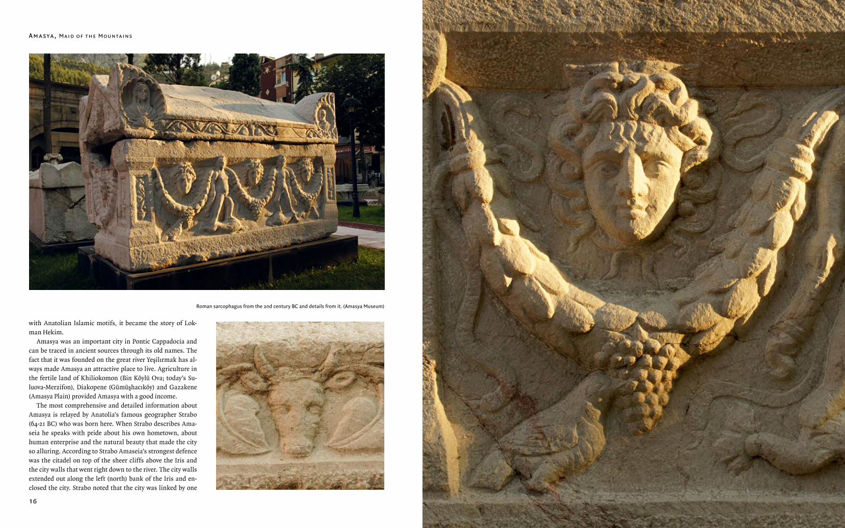
Roman sarcophagus from the 2nd century BC and details from it. (Amasya Museum)
Amasya, Maıd of the Mountaıns The Ancıent Cıt y of Ama seıa
18 19
was called Cappadocia Pontica. Therefore it is just as correct and scientific to name the Yeşilırmak Basin as Pontic Cap-padocia and the state that was founded subsequently as the Kingdom of Northern Cappadocia as the term the Kingdom of Pontus is.
Due to very scant records and few archaeological findings from the early periods of the Kingdom of Pontus it is very dif-ficult to trace Amasya’s urban development. The Yeşilırmak Basin was the heart of the state founded by the first king, Mithradates I (Ktistes, 301-206 BC) after his conquest of Amaseia, Gaziura (Turnal) and Zela (Zile). As a way to mani-fest his power Mithradates I (Ktistes) established a mint in Amaseia and the first coins minted in the Kingdom of Pontus were in gold and depict Athena. Mithradates I (Ktistes) was followed by Ariobarzanes (266-250 BC) who was followed by Mithradates (250-220 BC). The Galatian (Celtic) Trokmi Tribe came to Anatolia as mercenaries in 278-277 BC and their in-terest in the land provoked the Kingdom of Pontus. This led to a battle from which Mithradates II emerged as the victor. After the death of Mithradates II, Mithradates III (220-198 BC) acceded to the throne and the first coin with a portrait of the king was minted during his reign. This was a strong symbol of Amaseia’s power and prestige and a significant historical development. Pharnakes I (197-160), who acceded to the throne after Mithradates III, did not believe that the Yeşilırmak Basin held the future of the kingdom, so he turned to Paphlagonia on the Western Black Sea coast. His military force vanquished Sinope (now Sinop) and he made it the capi-tal in 183 BC. As the first political administrative centre of the Kingdom of Pontus, Amaseia was not affected by Sinope becoming the new capital. The city continued as the financial centre in the Yeşilırmak Basin as can be concluded from the coins that continued to be minted in the city by Mithradates VI (Eupator) and later by the Romans.
Amaseia was no longer the political centre but by virtue of being the founding- and first capital city of the Kingdom of Pontus it continued to receive respect and regard along with investments during the reigns of the last four kings: Mithri-dates IV (160-150 BC), Mithridates V (150-120 BC), Mithridates VI (120-63 BC) and Pharnakes II (63-47 BC).
The ancient cults played a very significant role in Pon-tic Cappadocia. Amaseia, Zela (Zile) and Comana Pontica (Gümenek) were the three major faith centres in the region. Zela and Comana were temple-states ruled by priests and Amaseia had the Ahura Mazda cult and altar, probably due to the Persian roots of Amaseia’s kings. Not much is known about the Ahura Mazda cult in the Kingdom of Pontus. Im-portant archaeological discoveries, however, reveal the cult’s
existence in Roman times. A coin minted in AD 224 features the portrait of Emperor Severus Alexander (AD 222-235) on the obverse and Amaseia Castle and the Kızlar Sarayı in relief on the reverse. It depicts high city walls and towers surround-ing a magnificent castle rising high above them. The coin provides very valuable visual information about the fabric of Amaseia city, its entities and important buildings in the 3rd century AD. There is a relief at the bottom of the coin show-ing the front of a tetrastyle temple on a podium with a tri-angular pediment and a saddle roof where the Seljuk Period bath is in today’s Kızlar Sarayı district. At the top of the coin is a portrayal of the peak of Mount Haşena where the castle now is. At the centre of the area is a temple with a triangular pediment and two columns at the front. On the right side of the temple on a plinth is a cylindrical fire altar depicted with huge f lames. The temple near the fire altar must be linked to the main god of the Zoroaster religion Ahura Mazda. This religion’s most powerful element of ritual is the fire cult and it seems to have produced an architectural dimension to the religious practices of Amaseia’s population in Roman times. During the salvage excavation carried out in Harşena Castle in 2007 by Amasya Museum it was observed that the position of the temple and the fire altar coincided with the uncovered Yıldırım Han Mosque. This site that has had a temple tradi-tion since the Hellenistic period with many faiths and cults would, as Amaseia became Turkified, eventually and natu-rally acquire a mosque in the Ottoman Period.
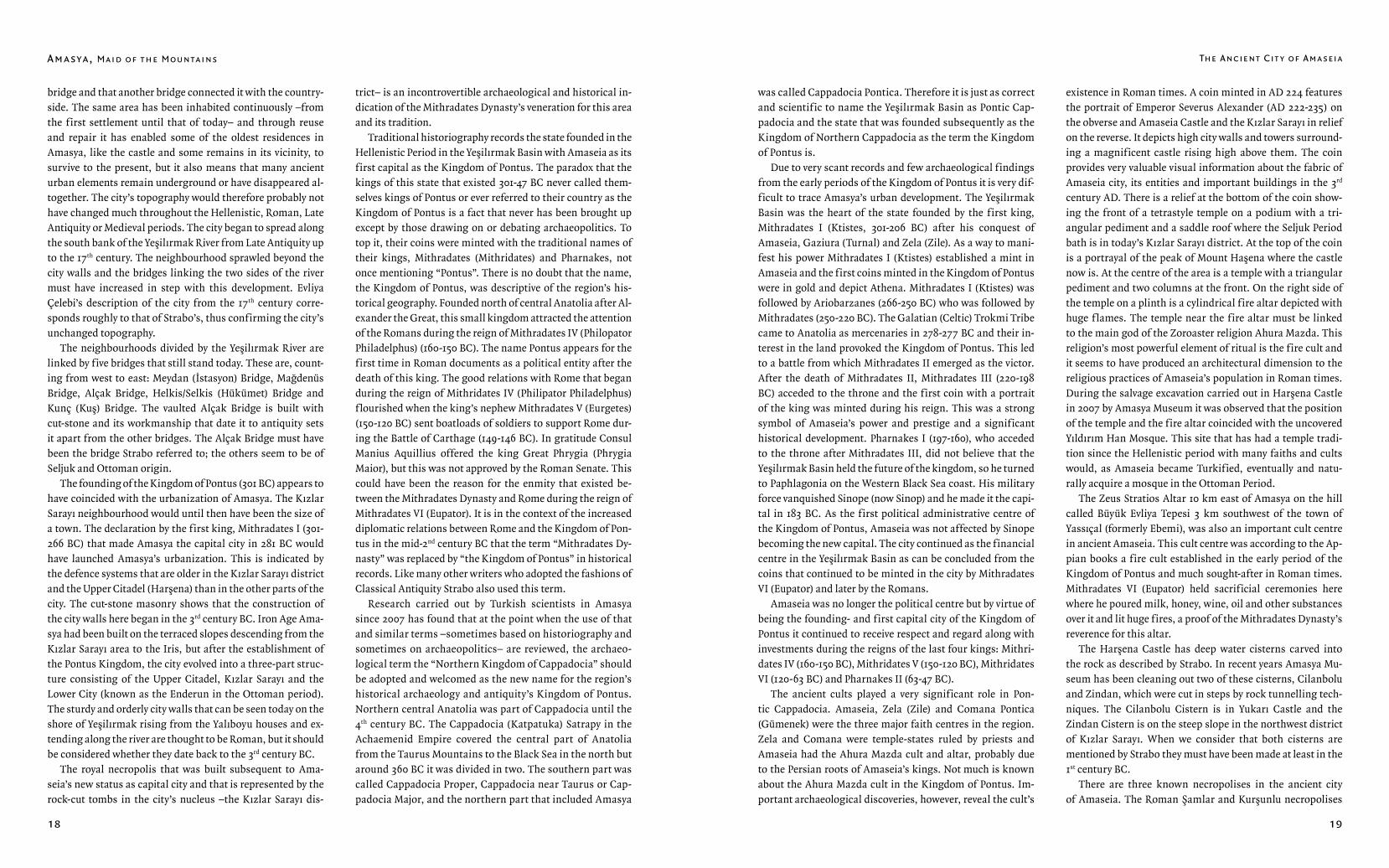
The Zeus Stratios Altar 10 km east of Amasya on the hill called Büyük Evliya Tepesi 3 km southwest of the town of Yassıçal (formerly Ebemi), was also an important cult centre in ancient Amaseia. This cult centre was according to the Ap-pian books a fire cult established in the early period of the Kingdom of Pontus and much sought-after in Roman times. Mithradates VI (Eupator) held sacrificial ceremonies here where he poured milk, honey, wine, oil and other substances over it and lit huge fires, a proof of the Mithradates Dynasty’s reverence for this altar.
The Harşena Castle has deep water cisterns carved into the rock as described by Strabo. In recent years Amasya Mu-seum has been cleaning out two of these cisterns, Cilanbolu and Zindan, which were cut in steps by rock tunnelling tech-niques. The Cilanbolu Cistern is in Yukarı Castle and the Zindan Cistern is on the steep slope in the northwest district of Kızlar Sarayı. When we consider that both cisterns are mentioned by Strabo they must have been made at least in the 1st century BC.
There are three known necropolises in the ancient city of Amaseia. The Roman Şamlar and Kurşunlu necropolises
bridge and that another bridge connected it with the country-side. The same area has been inhabited continuously –from the first settlement until that of today– and through reuse and repair it has enabled some of the oldest residences in Amasya, like the castle and some remains in its vicinity, to survive to the present, but it also means that many ancient urban elements remain underground or have disappeared al-together. The city’s topography would therefore probably not have changed much throughout the Hellenistic, Roman, Late Antiquity or Medieval periods. The city began to spread along the south bank of the Yeşilırmak River from Late Antiquity up to the 17th century. The neighbourhood sprawled beyond the city walls and the bridges linking the two sides of the river must have increased in step with this development. Evliya Çelebi’s description of the city from the 17th century corre-sponds roughly to that of Strabo’s, thus confirming the city’s unchanged topography.
The neighbourhoods divided by the Yeşilırmak River are linked by five bridges that still stand today. These are, count-ing from west to east: Meydan (İstasyon) Bridge, Mağdenüs Bridge, Alçak Bridge, Helkis/Selkis (Hükümet) Bridge and Kunç (Kuş) Bridge. The vaulted Alçak Bridge is built with cut-stone and its workmanship that date it to antiquity sets it apart from the other bridges. The Alçak Bridge must have been the bridge Strabo referred to; the others seem to be of Seljuk and Ottoman origin.
The founding of the Kingdom of Pontus (301 BC) appears to have coincided with the urbanization of Amasya. The Kızlar Sarayı neighbourhood would until then have been the size of a town. The declaration by the first king, Mithradates I (301-266 BC) that made Amasya the capital city in 281 BC would have launched Amasya’s urbanization. This is indicated by the defence systems that are older in the Kızlar Sarayı district and the Upper Citadel (Harşena) than in the other parts of the city. The cut-stone masonry shows that the construction of the city walls here began in the 3rd century BC. Iron Age Ama-sya had been built on the terraced slopes descending from the Kızlar Sarayı area to the Iris, but after the establishment of the Pontus Kingdom, the city evolved into a three-part struc-ture consisting of the Upper Citadel, Kızlar Sarayı and the Lower City (known as the Enderun in the Ottoman period). The sturdy and orderly city walls that can be seen today on the shore of Yeşilırmak rising from the Yalıboyu houses and ex-tending along the river are thought to be Roman, but it should be considered whether they date back to the 3rd century BC.
The royal necropolis that was built subsequent to Ama-seia’s new status as capital city and that is represented by the rock-cut tombs in the city’s nucleus –the Kızlar Sarayı dis-
trict – is an incontrovertible archaeological and historical in-dication of the Mithradates Dynasty’s veneration for this area and its tradition.
Traditional historiography records the state founded in the Hellenistic Period in the Yeşilırmak Basin with Amaseia as its first capital as the Kingdom of Pontus. The paradox that the kings of this state that existed 301-47 BC never called them-selves kings of Pontus or ever referred to their country as the Kingdom of Pontus is a fact that never has been brought up except by those drawing on or debating archaeopolitics. To top it, their coins were minted with the traditional names of their kings, Mithradates (Mithridates) and Pharnakes, not once mentioning “Pontus”. There is no doubt that the name, the Kingdom of Pontus, was descriptive of the region’s his-torical geography. Founded north of central Anatolia after Al-exander the Great, this small kingdom attracted the attention of the Romans during the reign of Mithradates IV (Philopator Philadelphus) (160-150 BC). The name Pontus appears for the first time in Roman documents as a political entity after the death of this king. The good relations with Rome that began during the reign of Mithridates IV (Philipator Philadelphus) f lourished when the king’s nephew Mithradates V (Eurgetes)(150-120 BC) sent boatloads of soldiers to support Rome dur-ing the Battle of Carthage (149-146 BC). In gratitude Consul Manius Aquillius offered the king Great Phrygia (Phrygia Maior), but this was not approved by the Roman Senate. This could have been the reason for the enmity that existed be-tween the Mithradates Dynasty and Rome during the reign of Mithradates VI (Eupator). It is in the context of the increased diplomatic relations between Rome and the Kingdom of Pon-tus in the mid-2nd century BC that the term “Mithradates Dy-nasty” was replaced by “the Kingdom of Pontus” in historical records. Like many other writers who adopted the fashions of Classical Antiquity Strabo also used this term.
Research carried out by Turkish scientists in Amasya since 2007 has found that at the point when the use of that and similar terms –sometimes based on historiography and sometimes on archaeopolitics– are reviewed, the archaeo-logical term the “Northern Kingdom of Cappadocia” should be adopted and welcomed as the new name for the region’s historical archaeology and antiquity’s Kingdom of Pontus. Northern central Anatolia was part of Cappadocia until the 4th century BC. The Cappadocia (Katpatuka) Satrapy in the Achaemenid Empire covered the central part of Anatolia from the Taurus Mountains to the Black Sea in the north but around 360 BC it was divided in two. The southern part was called Cappadocia Proper, Cappadocia near Taurus or Cap-padocia Major, and the northern part that included Amasya
Amasya, Maıd of the Mountaıns The Ancıent Cıt y of Ama seıa
20 21
sarcophagus with its exquisite artistic workmanship came from. The location of the Halifet Gazi Türbe indicates that the sarcophagus could not have come from afar. Considering the Roman past of the Venk graveyard located very near the medrese and the türbe makes it seem likely that this is where it was moved from. The many ancient marble doorjambs in the ruins of the medrese, including one with a Greek inscrip-tion, indicate that the city’s Roman west gate used to be in this area.
There are almost twenty rock-cut tombs in and around the antique city of Amaseia and they are spectacular examples of Anatolian monumental art in Pontic Cappadocia. The five monumental rock-cut tombs are in the Kızlar Sarayı district and the approach to Amaseia from the north is a sight worthy of the capital city of the most important kingdom in North Anatolia that the Hellenistic world had ever seen. The three easterly tombs that researchers have named A, B and C from right to left, and the two tombs in the west coded D and E describe a royal necropolis. The rock-cut tombs confirm that Amaseia is the first and only city in the region where Ana-tolian monumental art is successful. The tombs have been studied many times; the letter coding is based on their ages starting with the earliest tomb on the right followed by the later ones. While there is not much left of the tombs’ original decoration, Robert Fleischer’s research points out that the monumental rock-cut tombs have a distinctly eclectic look. It is thought that the A, B and D tombs had six or four Ionic columns with pediments in the same style. The facades of the C and E tombs with arched pediments but without columns seem to have their roots in old Anatolian architecture rather than in the Ionian tradition.
The hypothesis that these five tombs in the district of the Kızlar Sarayı belonged to the first five Pontic kings and were made when Amaseia was their capital is universally accepted. Yet in the light of what we know today it is rather difficult to determine which grave belongs to which king. It is made even more difficult because, apart from one, they bear no inscriptions nor do they offer any other kind of evidence. Strabo described the Kızlar Sarayı district and the rock-cut tombs as being in the shape of a bowl and said that this was where the kings’ palaces (basileion) and their tombs were. The area Strabo described as being protected by strong walls and having a view over the Iris has so far produced no remains or any other evidence linking it to a palace, but the name of the district, “Kızlar Sarayı” (Palace of the Maidens), must tes-tify to the area having had the same function throughout the Hellenistic, Roman, Late Antiquity, Middle Ages, Seljuk and Ottoman Eras.
The different features of the five rock-cut tombs in the Kızlar Sarayı district and the other two monumental tombs known as Tomb F and the Tomb of the High Priest Tes have been scrutinized by many different researchers.
TOMB A
This is the easternmost tomb of the five. The tomb faces south and is accessed by steps carved into the rock. It has got a rectangular portico with three steps, the first of which has regularly carved hollows. These are believed to have been made for a railing of some kind. It has been suggested that the column traces in front of Tomb A’s facade show that the tomb had six, probably Ionian, columns. There is a door in the facade that leads into the tomb. The exterior moulding is graduated outwards. The door is elevated above the terrace and the recesses and traces of iron clasps on the doorjamb show that the entrance was closed after the in-terment. There are notches and holes for an architectural element such as an altar or a table immediately in front of the door. The burial chamber is rectangular, almost square, and the ceiling is f lat. One step leads down into the cham-ber. A wide platform thought to be for the corpses follows the three walls in the shape of a U. The length of the plat-form suggests that the burial chamber was made for more than one burial. R. Fleischer believes that a corridor was meant to have been carved around the tomb. This, however, was abandoned, probably because of the cracks and fis-sures occurring in the rock. A corridor would have made the rock-tomb look like a free standing monumental tomb. This tomb is believed to be that of Mithradates I (Ktistes). As a king’s mausoleum had to be built while the king was still alive it can be dated to the early 3rd century BC.
TOMB B
Carved steps in the rock lead up from Tomb A to the plat-form of Tomb B and Tomb C. The steps have a line of recess-es. These were most likely made for a grid or a rail. The tomb faces southwest and there are circular marks in the portico that R. Fleischer believes derive from the bases of four no longer existing columns. Small regular holes have been dis-covered on the terrace f loor in front of the door leading into the tomb. The door is elevated from both the portico and the burial chamber. The burial chamber is almost square and the ceiling is vaulted. The tomb is surrounded on three sides
south and southeast of the castle also form the boundary to the settlement in this area of the Roman City. The third large necropolis is on the south bank of the Iris on the slope of the road coming from the west. A Christian graveyard that was later called “Venk” by the Armenians emerged near the graveyard known today as Memi Dede Mezarlığı.
There are not many Roman remains in Amaseia apart from the Alçak Bridge, the city walls rising from Yeşilırmak’s north banks over the Yalıboyu Evleri and the necropolises. Still, the Halifet Gazi Medrese (1209-1210) and the Halifet Gazi Türbe on its southeast corner in today’s Gökmedresi district feature very important spolia that sheds a light on the city’s Roman past. On the upper f loor of the typical Medieval Turkish Hal-
ifet Gazi Türbe (13th century) is a Roman marble sarcophagus that probably has been used for a mummified corpse. A re-used sarcophagus placed in a regular Medieval Turkish Küm-bet (tomb tower), or where the mummies are interred on the ground f loor naturally raises some questions. How a promi-nent figure believed to have Turkish and Islamic roots came to be in a pagan sarcophagus in Medieval Amasya remains a mystery. On top of that, the sarcophagus is not plain but is decorated with reliefs of Eros’s, Medusas and ram’s heads. Whether it was used because of a non-Muslim element in Halifet Gazi’s background or because figurative expression was tolerated in Islamic art in this period is a question that must be answered by experts. Another question is where this
Zeus Stratios Altar, Yassıçal.
The Ancıent Cıt y of Ama seıa
22 23
by a large passage in the shape of a U that has been carved to
separate it from the bedrock. The tomb is thought to belong
to Mithradates II which means that it was built in the late
3rd century BC. R. Fleischer believes that Tomb B must have
been made after Tomb C. Tomb D and Tomb E were carved
further away in the rocks to the west due to lack of space
east of Tomb C.
TOMB C
Tomb C is on the same level as Tomb B and is the western-
most of the eastern group. It is reached by steps carved into
the rock leading from Tomb A and has a rectangular portico
like the other two tombs. There is a pedestal right in front
of the southwest facing portico. Around the pedestal and on
top of it are marks from sockets forming a square and there
are also traces of a small channel. It is believed that this ped-
estal held an altar. On one of the side walls in front of the
tomb are neat rows of grooves, suggesting blocks of stone.
No remains from those stone blocks have been found. The
regular row of holes in front of the door is the same as those
observed in front of Tomb A and Tomb B. They appear to be
linked to architectural ornamentation in bronze or marble.
The tomb is entered through a rectangular door which is el-
evated from the ground like those of Tomb A and Tomb B.
The burial chamber is square and the ceiling is carved like a
vault. The f loor is rather smooth and gives no clue about the
method of the burial. Like Tomb B, there is a corridor carved
into the rock surrounding the tomb. This entirely separates
Tomb C from the bedrock behind it and helps achieve a
monumental character. It is believed that Tomb C is that of
Ariobarzanes. If this is the case, it would have been built in
the early second half of the 3rd century BC. It differs from
Tomb A and Tomb B in not having a triangular pediment or
column traces.
TOMB D
Tomb D and Tomb E are west of the Kızlar Sarayı district. The
facade of Tomb D faces south and the portico has five steps.
The triangular pediment rests on the sidewalls that frame the
portico. R. Fleischer submits that there were four columns
in front of Tomb D. This tomb is also surrounded by a cor-
ridor carved into the rock. The rectangular door opens into
the rectangular burial chamber that has a ceiling carved as a
vault. A very low platform lines the burial chamber on all four
walls. There is no other indication of how the burial was car-
ried out. A large chunk has fallen from the pediment on to the
terrace. This piece provides information about the ornamen-
tation of the triangular pediments on the other tombs. The
top of the pediment has mouldings. The stepped mouldings
f latten out and are followed by a rectangular component that
imitates wooden rafters and more gradual moulding below.
The tomb is believed to be that of Mithradates III. The king is
thought to have died around 190 BC so the tomb can probably
be dated to 2nd century BC.
TOMB E
Like the other tombs Tomb E has three steps and a wide por-
tico at the front. The walls on either side of the facade termi-
nate in an arch. A rectangular door approximately three me-
tres above the ground leads to the burial chamber. The ceil-
ing of the square burial chamber is carved as a vault. Nothing
that can give an insight into how the dead were interred has
survived. We understand that the tomb belongs to Pharnakes
from an inscription nearby. The inscription above the tomb
tells us that Castle Commander (phrourarkhos) Metrodoros
dedicated an altar to the gods on behalf of King Pharnakes.
This dates the tomb to the second quarter of the 2nd century
BC. The tomb has corridors carved on its east and west side.
These unfinished corridors suggest that the tomb was not
completed probably because King Pharnakes moved the capi-
tal from Amaseia to Sinope.
TOMB F
This rock-cut tomb is lower down from Tombs A and E. It has
a rectangular portico like the other tombs and stands on a
podium reached by three steps. The tomb’s facade is rectan-
gular and it has neither a pediment nor an arch. Two piers
rise on either side of the facade from plinths on the terrace
but they are not symmetrical. Like the other tombs, the door
to the burial chamber is elevated from the terrace f loor. A few
steps lead down into the burial chamber where there is a wide
platform on three of the walls. It is believed that the dead
were placed on this platform.
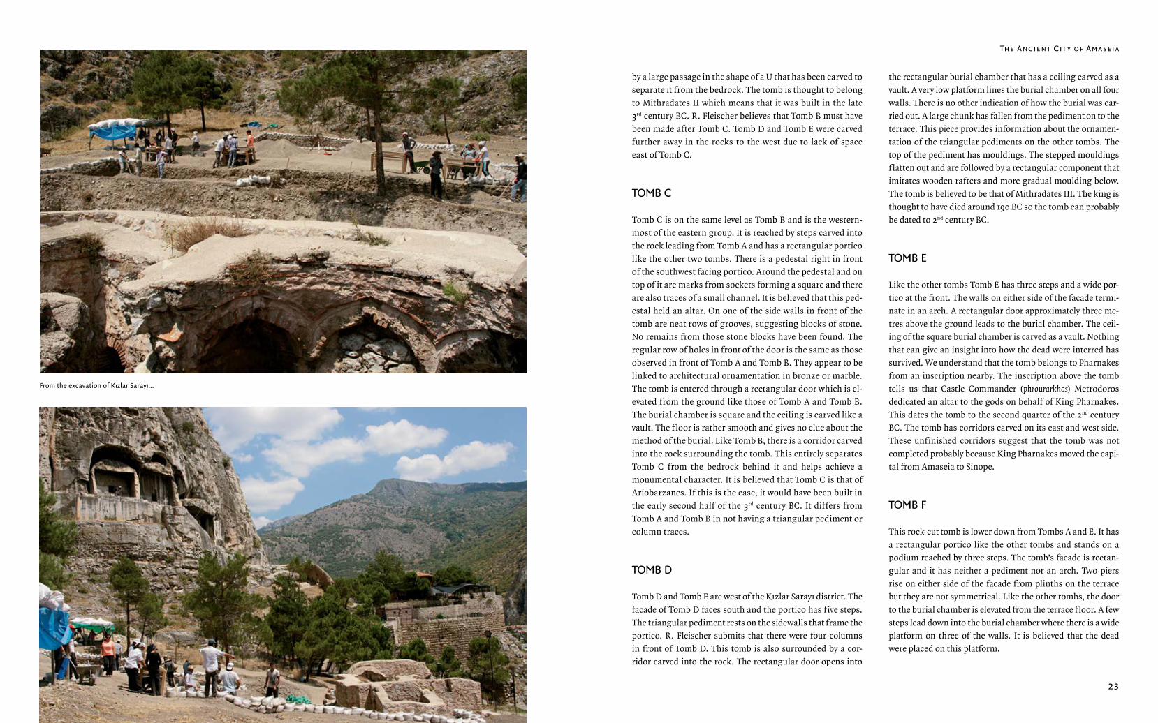
From the excavation of Kızlar Sarayı...
Amasya, Maıd of the Mountaıns The Ancıent Cıt y of Ama seıa
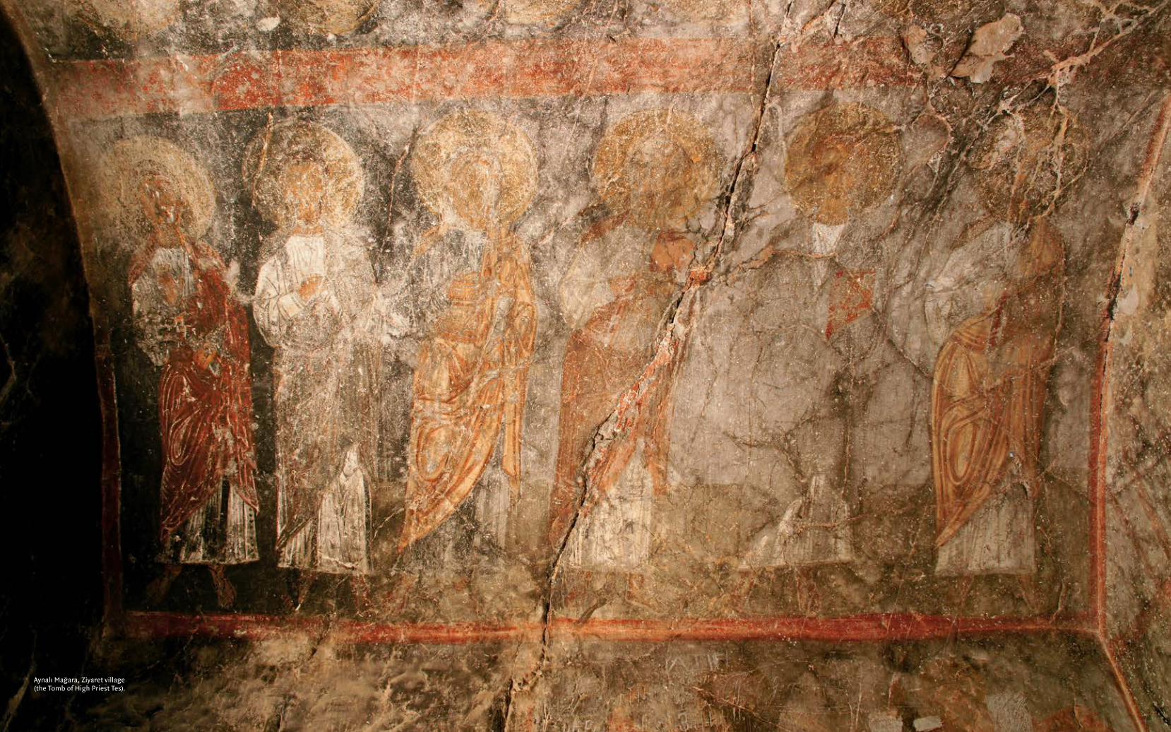
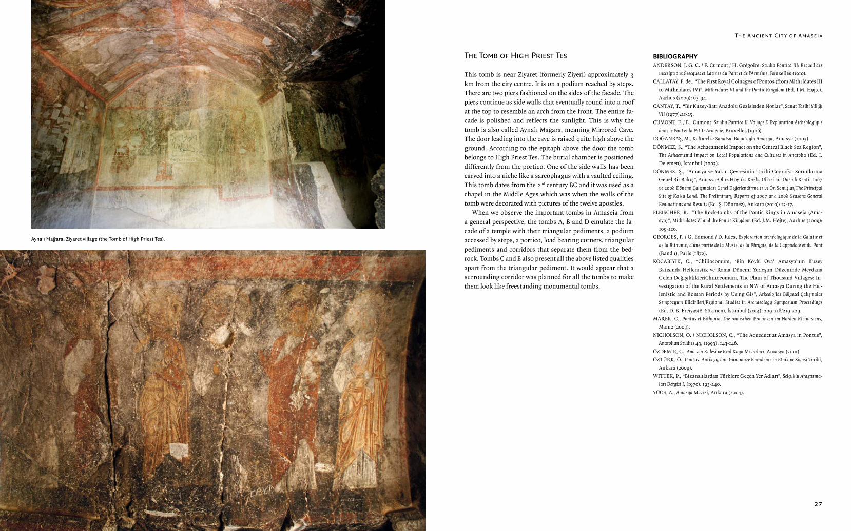
24 25Aynalı Mağara, Ziyaret village (the Tomb of High Priest Tes).
The Ancıent Cıt y of Ama seıa
26 27
The Tomb of Hıgh Prıest Tes
This tomb is near Ziyaret (formerly Ziyeri) approximately 3 km from the city centre. It is on a podium reached by steps. There are two piers fashioned on the sides of the facade. The piers continue as side walls that eventually round into a roof at the top to resemble an arch from the front. The entire fa-cade is polished and reflects the sunlight. This is why the tomb is also called Aynalı Mağara, meaning Mirrored Cave. The door leading into the cave is raised quite high above the ground. According to the epitaph above the door the tomb belongs to High Priest Tes. The burial chamber is positioned differently from the portico. One of the side walls has been carved into a niche like a sarcophagus with a vaulted ceiling. This tomb dates from the 2nd century BC and it was used as a chapel in the Middle Ages which was when the walls of the tomb were decorated with pictures of the twelve apostles.
When we observe the important tombs in Amaseia from a general perspective, the tombs A, B and D emulate the fa-cade of a temple with their triangular pediments, a podium accessed by steps, a portico, load bearing corners, triangular pediments and corridors that separate them from the bed-rock. Tombs C and E also present all the above listed qualities apart from the triangular pediment. It would appear that a surrounding corridor was planned for all the tombs to make them look like freestanding monumental tombs.
BIBLIOGRAPHYANDERSON, J. G. C. / F. Cumont / H. Grégoire, Studia Pontica III: Recueil des
inscriptions Grecques et Latines du Pont et de l’Arménie, Bruxelles (1910).
CALLATAŸ, F. de., “The First Royal Coinages of Pontos (from Mithridates III
to Mithridates IV)”, Mithridates VI and the Pontic Kingdom (Ed. J.M. Højte),
Aarhus (2009): 63-94.
CANTAY, T., “Bir Kuzey-Batı Anadolu Gezisinden Notlar”, Sanat Tarihi Yıllığı
VII (1977):21-25.
CUMONT, F. / E., Cumont, Studia Pontica II. Voyage D’Exploration Archéologique
dans le Pont et la Petite Arménie, Bruxelles (1906).
DOĞANBAŞ, M., Kültürel ve Sanatsal Boyutuyla Amasya, Amasya (2003).
DÖNMEZ, Ş., “The Achaeamenid Impact on the Central Black Sea Region”,
The Achaemenid Impact on Local Populations and Cultures in Anatolia (Ed. İ.
Delemen), İstanbul (2003).
DÖNMEZ, Ş., “Amasya ve Yakın Çevresinin Tarihi Coğrafya Sorunlarına
Genel Bir Bakış”, Amasya-Oluz Höyük. Kašku Ülkesi’nin Önemli Kenti. 2007
ve 2008 Dönemi Çalışmaları Genel Değerlendirmeler ve Ön Sonuçlar/The Principal
Site of Kašku Land. The Preliminary Reports of 2007 and 2008 Seasons General
Evaluations and Results (Ed. Ş. Dönmez), Ankara (2010): 13-17.
FLEISCHER, R., “The Rock-tombs of the Pontic Kings in Amaseia (Ama-
sya)”, Mithridates VI and the Pontic Kingdom (Ed. J.M. Højte), Aarhus (2009):
109-120.
GEORGES, P. / G. Edmond / D. Jules, Exploration archéologique de la Galatie et
de la Bithynie, d‘une partie de la Mysie, de la Phrygie, de la Cappadoce et du Pont
(Band 1), Paris (1872).
KOCABIYIK, C., “Chiliocomum, ‘Bin Köylü Ova’ Amasya’nın Kuzey
Batısında Hellenistik ve Roma Dönemi Yerleşim Düzeninde Meydana
Gelen Değişiklikler/Chiliocomum, The Plain of Thousand Villages: In-
vestigation of the Rural Settlements in NW of Amasya During the Hel-
lenistic and Roman Periods by Using Gis”, Arkeolojide Bölgesel Çalışmalar
Sempozyum Bildirileri/Regional Studies in Archaeology Symposium Proceedings
(Ed. D. B. Erciyas/E. Sökmen), İstanbul (2014): 209-218/219-229.
MAREK, C., Pontus et Bithynia. Die römischen Provinzen im Norden Kleinasiens,
Mainz (2003).
NICHOLSON, O. / NICHOLSON, C., “The Aqueduct at Amasya in Pontus”,
Anatolian Studies 43, (1993): 143-146.
ÖZDEMİR, C., Amasya Kalesi ve Kral Kaya Mezarları, Amasya (2001).
ÖZTÜRK, Ö., Pontus. Antikçağ’dan Günümüze Karadeniz’in Etnik ve Siyasi Tarihi,
Ankara (2009).
WITTEK, P., “Bizanslılardan Türklere Geçen Yer Adları”, Selçuklu Araştırma-
ları Dergisi I, (1970): 193-240.
YÜCE, A., Amasya Müzesi, Ankara (2004).
Aynalı Mağara, Ziyaret village (the Tomb of High Priest Tes).