Embed Size (px)
Citation preview
JOURNAL OF GEOPHYSICAL RESEARCH, VOL. 94, NO. B6, PAGES 7685-7729, JUNE 10, 1989
Magmatism at Rift Zones: The Generation of Volcanic Continental Margins
and Flood Basalts
ROBERT WHITE AND DAN MCKENZIE
Bullard Laboratories, Department of Earth Sciences, Cambridge, Enyland
When continents rift to form new ocean basins, the rifting'is sometimes accompanied by mas- sive igneous activity. We show that the production of magmatically active rifted margins and the effusion of flood basalts onto the adjacent continents can be explained by a simple model of rifting above a thermal anomaly in the underlying mantle. The igneous rocks are generated by decompression melting of hot asthenospheric mantle as it rises passively beneath the stretched and thinned lithosphere. Mantle plumes generate regions beneath the lithosphere typically 2000 km in diameter with temperatures raised 100-200øC above normal. These relatively small mantle temperature increases are sufficient to cause the generation of huge quantities of melt by decom- pression: an increase of 100øC above normal doubles the arnount of melt whilst a 200øC increase can quadruple it. In the first part of this paper we develop our model to predict the effects of melt generation for varying amounts of stretching with a range of mantle temperatures. The melt generated by decompression migrates rapidly upward, until it is either extruded as basalt flows or intruded into or beneath the crust. Addition of large quantities of new igneous rock to the crust considerably modifies the subsidence in rifted regions. Stretching by a factor of 5 above nor- real temperature mantle produces immediate subsidence of more than 2 km in order to maintain isostatic equilibrium. If the mantle is 150øC or more hotter than normal, the same amount of stretching results in uplift above sea level. Melt generated from abnormally hot mantle is more magnesian rich than that produced from normal temperature mantle. This causes an increase in seismic velocity of the igneous rocks eraplaced in the crust, from typically 6.8 km/s for normal mantle temperatures to 7.2 km/s or higher. There is a concomitant density increase. In the second part of the paper we review volcmaic continental margins and flood basalt provinces globally and show that they are always related to the thermal anomaly created by a nearby mantle plume. Our model of melt generation in passively upwelling mantle beneath rifting continental lithosphere can explain all the major rift-related igneous provinces. These include the Tertiary igneons provinces of Britain and Greenland and the associated volcanic continental maxgins caused by opening of the North Atlantic in the presence of the Iceland plume; the Paran& and parts of the Karoo flood basalts together with volcanic continental margins generated when the South Atlantic opened; the Deccan flood basalts of India and the Seychelles-Saya da Malha volcanic province created when the Seychelles split off India above the l•union hot spot; the Ethiopian and Yemen Traps created by rifling of the Red Sea and Gulf of Aden region above the Afar hot spot; and the oldest and probably originally the largest flood basalt province of the Karoo produced when Gondwana split apart. New continental splits do not always occur above thermal anomalies in the mantle caused by plumes, but when they do, huge quantities of igneous materiM are added to the continental crust. This is an important method of increasing the volume of the continental crust through geologic time.
Massive outbursts of igneous activity sometimes ac- company the rifting of continents as they are stretched prior to breaking to form new oceanic basins. Much of the evidence for this is now deeply buried on conti- nental margins under thick piles of sediment and, fur- thermore, is hidden underwater. In some places, huge areas of flood basalts were extruded onto the surface of
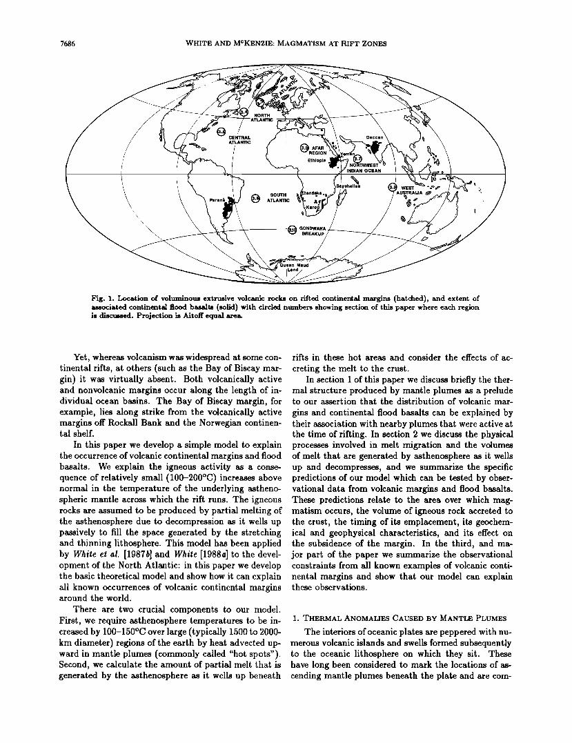
the adjacent continental areas at the same time as the continents were breaking apart: examples include the Deccan of India, the Karoo of southern Africa, and the Paran• of South America (Figure 1).
Copyright 1989 by the American Geophysical Up_ion.
Paper number 88JB03912. 0! 48-022 7/89/88 JB-03912505.00
Not only were huge quantities of igneous rock gen- erated when some continents rifted, but it appears that the bulk of it in any one area was emplaced in rather short periods of time. For example, when the north- ern North Atlantic opened during the early Tertiary, up to 10 million krn a of igneous rock was produced on the rifted margins in as little as 2-3 m.y. [White et al., 1987b]. The bulk of the Deccan Volcanic Province of 1-2.5 milhon km 3, to cite a continental flood basalt example, was extruded in probably only 0.5 m.y. [Cour- tillot and Cisowski, 1987]. These two examples are not insignificant: they are amongst the two largest volcanic events on Earth that have occurred since 200 Ma. They may as a consequence have had considerable effect on the biosphere, and may have been contributory factors to mass extinctions.
7685
7686 WHITE AND MCKENZIE: MAGMATISM AT RIFT ZONES
NORTH
CENTRAL ATLANTIC
Ethiopia
SOUTH ATLANTIC
(•GONDWANA BREAKUP
INDIAN OCEAN
iil•ea WEST • o •=,• )'=• t
Maud
Fig. 1. Location of voluminous extrusive volcanic rocks on rifted continental margins (hatched), and extent of associated continental flood basalts (solid) with circled numbers showing section of this paper where each region is discussed. Projection is Airoff equal are•
Yet, whereas volcanism was widespread at some con- tinental rifts, at others (such as the Bay of Biscay mar- gin) it was virtually absent. Both volcanically active and nonvolcanic margins occur along the length of in- dividual ocean basins. The Bay of Biscay margin, for example, lies along strike from the volcanically active margins off Rockall Bank and the Norwegian continen- tal shelf.
In this paper we develop a simple model to explain the occurrence of volcanic continental margins and flood basalts. We explain the igneous activity as a conse- quence of relatively small (100-200øC) increases above normal in ,•_A ß ...... ß ..... t,•_ J • ß UI bll• unuenyir, g astheno- bll• b•lllp•[i•l,b UI-•
spheric mantle across which the rift runs. The igneous rocks are assumed to be produced by partial melting of the asthenosphere due to decompression as it wells up passively to fill the space generated by the stretching and thinning lithosphere. This model has been applied by White et al. [1987b] and White [1988a] to the devel- opment of the North Atlantic: in this paper we develop the basic theoretical model and show how it can explain all known occurrences of volcanic continental margins around the world.
There are two crucial components to our model. First, we require asthenosphere temperatures to be in- creased by 100-150øC over large (typically 1500 to 2000- km diameter) regions of the earth by heat advected up- ward in mantle plumes (commonly called "hot spots"). Second, we calculate the amount of partial melt that is generated by the asthenosphere as it wells up beneath
riffs in these hot areas and consider the effects of ac-
creting the melt to the crust. In section 1 of this paper we discuss briefly the ther-
mal structure produced by mantle plumes as a prelude to our assertion that the distribution of volcanic mar-
gins and continental flood basalts can be explained by their association with nearby plumes that were active at the time of rifling. In section 2 we discuss the physical processes involved in melt migration and the volumes of melt that are generated by asthenosphere as it wells up and decompresses, and we summarize the specific predictions of our model which can be tested by obser- vational data from volcanic margins and flood basalts. These predictions relate to the area over which mag- matism occurs, the volume of igneous rock accreted to the crust, the timing of its emplacement, its geochem- ical and geophysical characteristics, and its effect on the subsidence of the margin. In the third, and ma- jor part of the paper we summarize the observational constraints from all known examples of volcanic conti- nental margins and show that our model can explain these observations.
1. THERMAL ANOMALIES CAUSED BY MANTLE PLUMES
The interiors of oceanic plates are peppered with nu- merous volcanic islands and swells formed subsequently to the oceanic lithosphere on which they sit. These have long been considered to mark the locations of as- cending mantle plumes beneath the plate and are com-
WHITE AND MCKENZIE: MAGMATISM AT RIFT ZONES 7687
TABLE 1. Oceanic Swells
Swell Crustal Age, Residual Depth Anomaly Width of Swell, Source at Center,*
]Via m km
Bermuda 110 1000 800 Derrick et al. [1986] Cape Verde 125 1900 1550 Costthey and White [1986] Cook- Austral 46 650 1250 Crough [1978] Crozet 67 ~ 800 ) 1000 Coatthey and Recq [1986] Hawaii 90 1200 1200 •on Herzen et al. [1982] Iceland 0 ~ 2000 2000 this study Marquests 45 ~ 800 ~ 1500 Crough and Jarrard [1981] Reunion 67 1050 Croagh [1978] Society 70 1100 Crough [1978]
*Residual depth anomaly with respect to normal oceanic depth [from Parsons and Sclater, 1977] attributed to thermal uplift.
monly called hot spots [Wilson, 1963, 1965; Morgan, 1971, 1981]. Recent heat flow measurements across the Hawaiian swell Iron Hersen et al., 1982], the Bermuda swell [Deirick et al., 1986], and the Cape Verde swell [Courthey and White, 1986] have confirmed that they do indeed have a deep thermal origin. The heat flow across the Cape Verde swell, for example, reaches 25% above normal at the center compared with that through lithosphere of the same age away from the swell.
Although mantle plumes undoubtedly exist under continents too, we shall for the moment consider those under oceanic lithosphere because the thermal struc- ture of the oceanic lithosphere is more straightforward to predict than that under old continents and the distri- bution of suboceanic plumes can be mapped using satel- lite altimetry. Furthermore, seafloor elevations caused by hot spot uplift are generally preserved underwater because there is little erosion. Since the age of oceanic crust is easy to determine using seafloor spreading mag- netic anomalies and the seafloor depth increases mono- tonically with age in a well-known manner as the litho-
sphere cools [e.g., Parsons and Sclater, 1977], we can readily determine the depth anomaly above an oceanic plume. By contrast, on land the effects of subaerial erosion quickly modify the uplift caused by underlying plumes, and a variety of other causes can produce ele- vation anomalies. It is harder therefore to identify the position and size of a sub continental hot plume.
The effect of suboceanic mantle plumes is to uplift the existing seafloor by typically 1000-2000 m at the center. The seafloor is elevated over a 1000 to 2000-km-
diameter region. The swells that cover the largest area tend to exhibit the greatest uplift. In Table I we show a compilation of hot spot swell statistics drawn from a number of different sources to show their typical di- mensions. All these swells also exhibit prominent geoid anomalies and are caused by deep thermal anomalies.
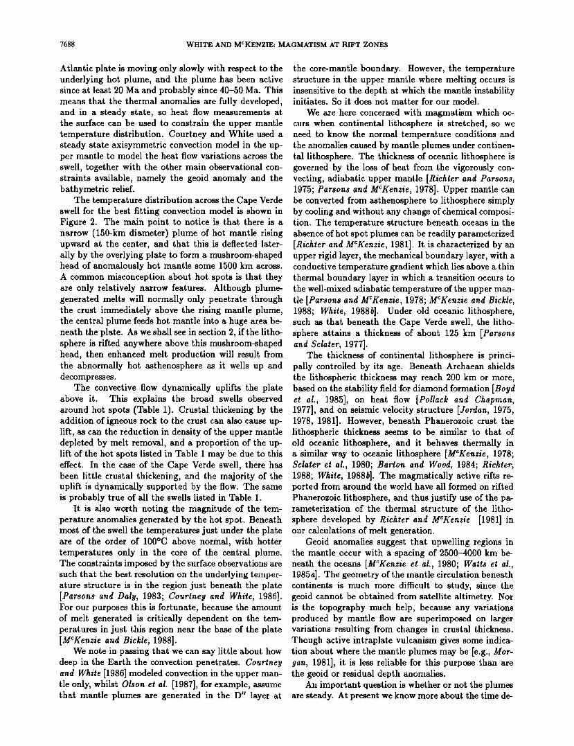
The way in which a mantle plume modifies the up- per mantle temperatures is well displayed by studies of the Cape Verde swell published by Courtney and White [1986], so we use this as an example. The Cape Verde swell is a good example to model because the overlying
_/,.•-•oo •---'------'•oo •oo • -•oo---• _ 200 -200
km _ km thenosphere
400 - 400
600- __ -600
500 km I •
Fig. 2. Temperature variations seen in cross-section through the Cape Verde swell from the best fitting axisymmet- ric convection model of Courthey and White [1986]. Temperature anomalies are labeled in degrees Celsius with respect to the mean asthenosphere temperature. Note the narrow central rising plume and the broad mushroom- shaped head of hot material deflected laterally by the overlying plate.
7688 WHITE AND MCKENZIE: MAGMATISM AT RIFT ZONES
Atlantic plate is moving only slowly with respect to the underlying hot plume, and the plume has been active since at least 20 Ma and probably since 40-50 Ma. This means that the thermal anomalies are fully developed, and in a steady state, so heat flow measurements at the surface can be used to constrain the upper mantle temperature distribution. Courtney and White used a steady state axisymmetric convection model in the up- per mantle to model the heat flow variations across the swell, together with the other main observational con- straints available, namely the geoid anomaly and the bathymetric relief.
The temperature distribution across the Cape Verde swell for the best fitting convection model is shown in Figure 2. The main point to notice is that there is a narrow (150-km diameter) plume of hot mantle rising upward at the center, and that this is deflected later- ally by the overlying plate to form a mushroom-shaped head of anomalously hot mantle some 1500 km across. A common misconception about hot spots is that they are only relatively narrow features. Although plume- generated melts will normally only penetrate through the crust immediately above the rising mantle plume, the central plume feeds hot mantle into a huge area be- neath the plate. As we shall see in section 2, if the litho- sphere is rifted anywhere above this mushroom-shaped head, then enhanced melt production will result from the abnormally hot asthenosphere as it wells up and decompresses.
The convective flow dynamically uplifts the plate above it. This explains the broad swells observed around hot spots (Table 1). Crustal thickening by the addition of igneous rock to the crust can also cause up- lift, as can the reduction in density of the upper mantle depleted by melt removal, and a proportion of the up- lift of the hot spots listed in Table I may be due to this effect. In the case of the Cape Verde swell, there has been little crustal thickening, and the majority of the uplift is dynamically supported by the flow. The same is probably true of all the swells listed in Table 1.
It is also worth noting the magnitude of the tem- perature anomalies generated by the hot spot. Beneath most of the swell the temperatures just under the plate are of the order of 100øC above normal, with hotter temperatures only in the core of the central plume. The constraints imposed by the surface observations are such that the best resolution on the underlying temper- ature structure is in the region just beneath the plate [Parsons and Daly, 1983; Courlney and While, 1986]. For our purposes this is fortunate, because the amount of melt generated is critically dependent on the tem- peratures in just this region near the base of the plate [MCKenzie and Bickle, 1988].
We note in passing that we can say little about how deep in the Earth the convection penetrates. Courlney and While [1986] modeled convection in the upper man- tle only, whilst Olson el al. [1987], for example, assume that mantle plumes are generated in the D • layer at
the core-mantle boundary. However, the temperature structure in the upper mantle where melting occurs is insensitive to the depth at which the mantle instability initiates. So it does not matter for our model.
We are here concerned with magmatism which oc- curs when continental lithosphere is stretched, so we need to know the normal temperature conditions and the anomalies caused by mantle plumes under continen- tal lithosphere. The thickness of oceanic lithosphere is governed by the loss of heat from the vigorously con- vecting, adiabatic upper mantle [Richter and Parsons, 1975; Parsons and MCKenzie, 1978]. Upper mantle can be converted from asthenosphere to lithosphere simply by cooling and without any change of chemical composi- tion. The temperature structure beneath oceans in the absence of hot spot plumes can be readily parameterized [Richter and MCKenzie, 1981]. It is characterized by an upper rigid layer, the mechanical boundary layer, with a conductive temperature gradient which lies above a thin thermal boundary layer in which a transition occurs to the well-mixed adiabatic temperature of the upper man- tle [Parsons and MCKenzie, 1978; MCKenzie and Bickle, 1988; White, 1988b]. Under old oceanic lithosphere, such as that beneath the Cape Verde swell, the litho- sphere attains a thickness of about 125 km [Parsons and Sclater, 1977].
The thickness of continental lithosphere is princi- pally controlled by its age. Beneath Archaean shields the lithospheric thickness may reach 200 km or more, based on the stability field for diamond formation [Boyd et al., 1985], on heat flow [Pollack and Chapman, 1977], and on seismic velocity structure [Jordan, 1975, 1978, 1981]. However, beneath Phanerozoic crust the lithospheric thickness seems to be similar to that of old oceanic lithosphere, and it behaves thermally in a similar way to oceanic lithosphere [MCKenzie, 1978; Sclater et al., 1980; Barton and Wood, 1984; Richter, 1988; White, 1988b]. The magmatically active rifts re- ported from around the world have all formed on rifted Phanerozoic lithosphere, and thus justify use of the pa- rameterization of the thermal structure of the litho-
sphere developed by Richter and MCKenzie [1981] in our calculations of melt generation.
Geoid anomalies suggest that upwelling regions in the mantle occur with a spacing of 2500-4000 km be- neath the oceans [MCKenzie et al., 1980; Watts et al., 1985a]. The geometry of the mantle circulation beneath continents is much more difficult to study, since the geoid cannot be obtained from satellite altimetry. Nor is the topography much help, because any variations produced by mantle flow are superimposed on larger variations resulting from changes in crustal thickness. Though active intraplate vulcanism gives some indica- tion about where the mantle plumes may be [e.g., Mor- gan, 1981], it is less reliable for this purpose than are the geoid or residual depth anomalies.
An important question is whether or not the plumes are steady. At present we know more about the time de-
WHITE AND MCKENZIE: MAGMATISM AT RIFT ZONES 7689
pendence of two-dimensional numerical convection than we do about that of the mantle. Vigorously convecting systems show various forms of time dependence in three dimensions. Most studies have been concerned with
constant viscosity fluids heated from below. When the Rayleigh number is large (larger than about 105 ) the convective planform consists of hot and cold vertical sheets radiating from points. The flow becomes time dependent when hot and cold blobs are carried round the cells. The planform of mantle circulation more often consists of plumes than of sheets, probably because the viscosity of the material depends so strongly on tem- perature.
When constant viscosity fluids are heated inter- nally, the planform consists of narrow sinking plumes in three dimensions..[Whilehead and Chen, 1970; Craig and MCKenzie, 1987]; or sinking sheets if the flow is re- stricted to two dimensions [MCKenzie el al., 1973]. Such circulations become time dependent in a different way. Existing plumes slowly approach each other and then join suddenly. As this process reduces the number of plumes, and therefore the heat transport, new plumes must form. They do so through boundary layer instabil- ities at places which are furthest from existing plumes. A similar process has recently been described in two- dimensional convection heated from below [Jarvis, 1984] at a Rayleigh number of 1.5 x 10⁹ with free boundaries. The necessary Rayleigh number for this process to occur is likely to be lower for three-dimensional circulations, and is likely to be further reduced if one or both of the boundaries is rigid and if the viscosity is temperature dependent. All these effects reduce the stability of the boundary layers. The time scale for plumes to move together is likely to be at least 100 m.y., whereas the time taken for an instability of the boundary layer to develop is unlikely to exceed 10 m.y.
There is as yet little information about the time de- pendence of mantle convection. That of the large-scale flow is controlled by the movement of the large plates. Studies of hot spots [Molnar and Aiwalet, 1973; Molnar and $1ock, 1987; Sager and Bleil, 1987] show that they move relative to each other at rates of 10-30 mm/yr, but do not yet provide evidence that they attract each other in the manner seen in the experiments. The be- ginning of a hot spot has also not been observed, but numerical experiments suggest that the boundary layer instability will produce a roughly spherical blob 100- 200øC hotter than the average interior temperature of the mantle and will contain about 5 x 10⁶ km 3 of ma-
terial. As the blob approaches the upper boundary, its shape is changed into a fiat circular pillow by the stag- nation point flow. This blob will start a mantle plume whose radius will be about half that of the blob. The
rate of heat transport by the blob is likely to be about a factor of 5 greater than the steady heat transport of the plume.
In the absence of direct measurements across a con-
tinental hot spot, because of the difiqculties mentioned
earlier, we use the thermal model developed for the Cape Verde swell as a good analog of conditions prior to rifting above a continental mantle plume. Not only does the Cape Verde swell lie over old oceanic lithosphere which therefore probably has a thermal structure simi- lar to Phanerozoic continental lithosphere, but it is also producing only minor volcanic products, despite its ma- ture age. We therefore take it to be representative of the thermal structure prior to continental rifting and be- fore the production of voluminous melt. We would not expect every mantle plume to be identical in thermal structure to the Cape Verde model. Indeed the range of sizes of the swells listed in Table 1 gives some idea of their variability. But we do expect them to exhibit sev- eral general features in common. We summarize these as follows.
1. Hot spots comprise a narrow (150-200 km wide) central plume of rising mantle with abnormally high temperatures. 2. The convected material spreads out under the plate
to form a mushroom-shaped head of asthenosphere with temperatures raised typically 100-200øC above normal. 3. The lateral extent of the hot asthenosphere in the
mushroom head is 1000-2000 km in diameter.
4. The convecting mantle in the hot spot causes dy- namic uplift which reaches a maximum of 1000-2000 m. 5. The start of a new plume is associated with the
arrival of a large blob containing about 5 x 10⁶ km 3 of material 100-200øC hotter than the mantle interior
temperature at the base of the plate. The rate of mass transport and the temperature of the initial blob are higher than those of the subsequent steady state man- tle plume, providing transient conditions particularly favorable to excess magmatism at the initiation of a new plume.
2. MELT GENERATION BENEATH
RIFTING LITHOSPHERE
When lithosphere is thinned tectonically the under- lying asthenosphere wells up to fill the space. As the asthenosphere decompresses, it partially melts. The amount of melt generated can be calculated readily, provided the upwelling is assumed to occur at constant entropy [MCKenzie, 1984].
In the last few years there has been a great deal of interest in the separation of melt from a partially molten rock. This work has led to a better understanding of the processes involved. Two principal results are of con- cern to this discussion. The first concerns the amount
of melt which fails to separate from the residue. Those who have considered this problem agree that this melt fraction is about 1% or 2% for basalts [Ahem and Tur- cotte, 1975; MCKenzie, 1985], or considerably less than the uncertainties in the melting calculations. M. Chea- die (personal communication, 1988) has recently stud- ied this problem in more detail, and has shown that the earlier calculations have overestimated the quantity of
7690 WHITE AND MCKENZIE: MAGMATISM AT RIFT ZONES
melt that remains behind with the residue. It is there-
fore sufficiently small to be neglected in the present cal- culations.
The second result involves the question of whether melt can flow significant horizontal distances as it sepa- rates from the residual matrix. The extent of horizontal
flow is controlled by the pressure gradient in the matrix, which is in turn controlled by the matrix viscosity. This viscosity is not likely to exceed the value of 102• Pa s used by Spiegelman and MCKenzie[1987], who found a deflection of only 30 km at oceanic ridge axes. Ribe and Smooke [1987] have shown that the influence of the ma- trix viscosity on melt separation from plumes is even smaller, and Scott and Stevenson [1989] have argued that the matrix viscosity is i or 2 orders of magnitude less than 102• Pa s, and therefore deflection of melt as it separates is even less important than Spiegelman and MCKenzie[1987] believed. For our present concerns these arguments are of little interest: all authors are agreed that the horizontal deflection of melt between its source and the surface is no greater than 30 km.
These calculations therefore allow us to assume that
all melt produced by decompression melting separates from its residue and moves directly upward. It is then either erupted at the surface or emplaced in the crust. These assumptions are now soundly based and greatly simplify the calculations.
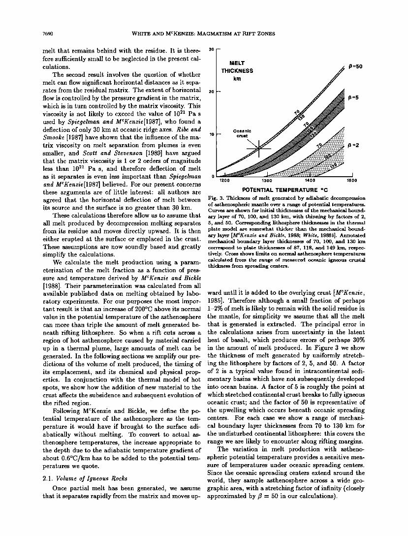
We calculate the melt production using a param- eterization of the melt fraction as a function of pres- sure and temperature derived by MCKenzie and Bickle [1988]. Their parameterization was calculated from all available published data on melting obtained by labo- ratory experiments. For our purposes the most impor- tant result is that an increase of 200øC above its normal
value in the potential temperature of the asthenosphere can more than triple the amount of melt generated be- neath rifting lithosphere. So when a rift cuts across a region of hot asthenosphere caused by material carried up in a thermal plume, large amounts of melt can be generated. In the following sections we amplify our pre- dictions of the volume of melt produced, the timing of its emplacement, and its chemical and physical prop- erties. In conjunction with the thermal model of hot spots, we show how the addition of new material to the crust affects the subsidence and subsequent evolution of the rifted region.
Following MCKenzie and Bickle, we define the po- tential temperature of the asthenosphere as the tem- perature it would have if brought to the surface adi- abatically without melting. To convert to actual as- thenosphere temperatures, the increase appropriate to the depth due to the adiabatic temperature gradient of about 0.6øC/km has to be added to the potential tem- peratures we quote.
2.1. Volume of Igneous Rocks
Once partial melt has been generated, we assume that it separates rapidly from the matrix and moves up-
30 I MELT !THICKNESS ... p=50
km
20
is=5
p=2 ...
1200 1300 1400 1500
POTENTIAL TEMPERATURE *C
Fig. 3. Thickness of melt generated by adiabatic decompression of asthenospheric mantle over a range of potential temperatures. Curves are shown for initial thicknesses of the mechanical bound-
ary layer of 70, 100, and 130 km, with thinning by factors of 2, 5, and 50. Corresponding lithosphere thicknesses in the thermal plate model are somewhat thicker than the mechanical bound- ary layer [MCKenzie and Bickle, 1988; White, 1988b]. Annotated mechanical boundary layer thicknesses of 70, 100, and 130 km correspond to plate thicknesses of 87, 118, and 149 kin, respec- tively. Cross shows limits on normal asthenosphere temperatures calculated from the range of measured oceanic igneous crustal thickness from spreading centers.
ward until it is added to the overlying crust [MCKenzie, 1985]. Therefore although a small fraction of perhaps 1-2% of melt is likely to remain with the solid residue in the mantle, for simplicity we assume that all the melt that is generated is extracted. The principal error in the calculations arises from uncertainty in the latent heat of basalt, which produces errors of perhaps 30% in the amount of melt produced. In Figure 3 we show the thickness of melt generated by uniformly stretch- ing the lithosphere by factors of 2, 5, and 50. A factor of 2 is a typical value found in intracontinental sedi- mentary basins which have not subsequently developed into ocean basins. A factor of 5 is roughly the point at which stretched continental crust breaks to fully igneous oceanic crust; and the factor of 50 is representative of the upwelling which occurs beneath oceanic spreading centers. For each case we show a range of mechani- cal boundary layer thicknesses from 70 to 130 km for the undisturbed continental lithosphere: this covers the range we are likely to encounter along rifting margins.
The variation in melt production with astheno- spheric potential temperature provides a sensitive mea- sure of temperatures under oceanic spreading centers. Since the oceanic spreading centers extend around the world, they sample asthenosphere across a wide geo- graphic area, with a stretching factor of infinity (closely approximated by • = 50 in our calculations).
WHITE AND MCKENZIE: MAGMATISM AT RIFT ZONES 7691
Apart from crustal thickening caused by underplat- ing beneath mantle plumes [e.g., Watts et al., 1985b], and thinning near fracture zones [White et al., 1984], the thickness of the igneous portion of oceanic crust is remarkably consistent the world over. This is true regardless of age or of spreading rate. Compilations based only on travel time inversions of seismic refrac- tion profiles indicate a mean igneous crustal thickness of 6.5 km [Hill, 1957; Raitt, 1963]. More recent de- terminations based on synthetic seismogram modeling provide similar conclusions, suggesting normal oceanic thickness of 6-7 km, with an outer range from 4.5 to 8.5 km [$pudich and Orcutt, 1980; White, 1984]. From this we infer that the normal asthenosphere potential temperature is 1280øC, with a range of q-30øC (shown by a cross in Figure 3). Foucher et al. [1982] came to a similar conclusion: using a simple analytic expression for the degree of partial melting as a function of temper- ature and depth [from Ahem and Turcotte, 1979], they found that the potential temperature of the astheno- sphere required to produce average thickness oceanic crust is between 1262 and 1295øC.
The volume of melt generated depends only on the amount of lithosphere thinning and the temperature of the underlying asthenosphere. Thickest igneous sec- tions are found on rifted continental margins where they have cut across the 'mushroom heads' of abnormally hot mantle brought up in a plume. However, any minor rift- ing above the hot asthenosphere will produce localized igneous activity on a smaller scale, and this explains, for example, the broad occurrence of similarly aged vol- canic rocks across a 2000-km-wide area in the British
Tertiary igneous province. The area over which volcanic rocks are found de-
pends not just on the location of the rift but also on how far the lavas flow. Huge areas of flood basalts are often found on the continents adjacent to rifts. Their outward flow may be assisted by the fact that the rifted region which forms the source is uplifted by typically 1- 2 km (also see section 2.4).
2.2. Timing of Volcanism
Partial melt is generated as the asthenosphere wells up passively beneath the thinning lithosphere. The tim- ing of volcanism seen at the surface thus depends on the time and rate of lithospheric thinning and on the time it takes for the melt to move upward from the zone of melting in the mantle to the surface. The basalts that are formed by asthenosphere decompression sepa- rate out from the matrix very rapidly, and the bulk of the melt will reach the surface in less than I m.y. af- ter its formation [MCKenzie, 1985]. On geological time scales it is essentially simultaneous with the rifting.
When continents break apart, there is often a long precursory period of small-scale rifting, sometimes dis- tributed over a broader region than the final split. This is likely to cause minor volcanism over a broad region for several millions of years prior to the continental sep-
aration. However, once the continents start to separate, they often do so rapidly. It is during this main phase of rifting that the voluminous outburst of magmatism occurs. We expect most of the continental margin vol- canism and continental flood basalt flows to be erupted during a short period contemporaneous with the main rifting.
2.3. Properties of the Igneous Rocks
Even with high asthenosphere temperatures and large amounts of stretching, the degree of partial melt- ing does not exceed about 30%. Infinite stretching with asthenosphere at a normal potential temperature of 1280øC produces melt with the composition of mid- ocean ridge basalts (MORB). As the potential temper- ature of the asthenosphere is increased up to 1480øC, some 200øC above normal, the percentage of MgO in- creases systematically from about 10% to 18%, and the percentage of Na20 simultaneously decreases. Thinning the lithosphere by a factor of 2 above asthenosphere at 1480øC produces alkali basalts passing to tholeiitic basalts as the stretching is increased further.
These systematic chemical changes in the melt are a sensitive indication of the asthenosphere temperature. Thus picritic basalts with a high percentage of MgO found on Disko Island in west Greenland [Clarke, 1970] are indicative of abnormally high asthenosphere tem- peratures. Similarly, the increase in percentage of Na20 of oceanic basalts as one moves away from the hot spot under Iceland [Klein and Langmuir, 1987] is a sensitive measure of decreasing asthenosphere temperature away from the central mantle plume.
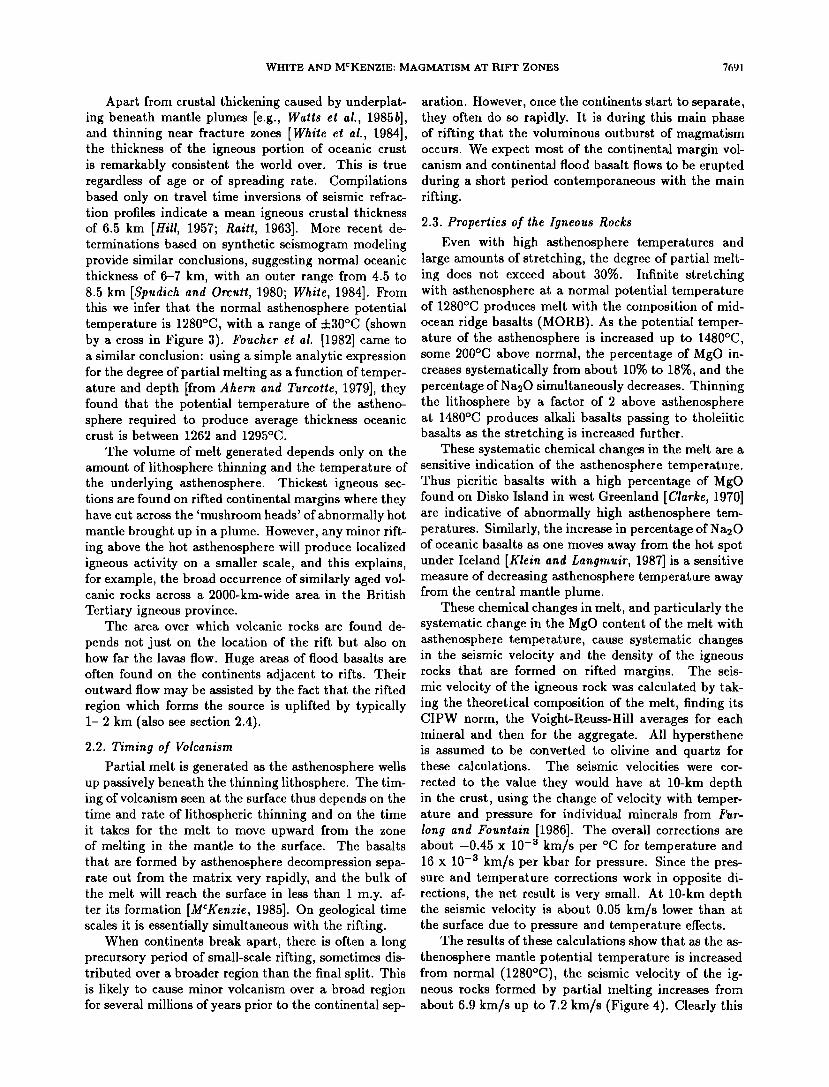
These chemical changes in melt, and particularly the systematic change in the MgO content of the melt with asthenosphere temperature, cause systematic changes in the seismic velocity and the density of the igneous rocks that are formed on rifted margins. The seis- mic velocity of the igneous rock was calculated by tak- ing the theoretical composition of the melt, finding its CIPW norm, the Voight-Reuss-Hill averages for each mineral and then for the aggregate. All hypersthene is assumed to be converted to olivine and quartz for these calculations. The seismic velocities were cor-
rected to the value they would have at 10-km depth in the crust, using the change of velocity with temper- ature and pressure for individual minerals from Fur- long and Fountain [1986]. The overall corrections are about -0.45 x 10 -3 km/ts per øC for temperature and 16 x 10 -3 km/s per kbar for pressure. Since the pres- sure and temperature corrections work in opposite di- rections, the net result is very small. At 10-km depth the seismic velocity is about 0.05 km/s lower than at the surface due to pressure and temperature effects.
The results of these calculations show that as the as-
thenosphere mantle potential temperature is increased from normal (1280øC), the seismic velocity of the ig- neous rocks formed by partial melting increases from about 6.9 km/s up to 7.2 km/s (Figure 4). Clearly this
7692 WHITE AND MCKENZIE: MAGMATISM AT RIFT ZONES
7.5
SEISMIC
VELOCITY
(km/s)
7.0 ß
6.5 I I 1300 1400 1500 1600
POTENTIAL TEMPERATURE oc
Fig. 4. Theoretical compressional wave seismic velocity at a depth of 10 km of igneous rock formed by decompression melting of mantle at a range of potential temperatures (see text for details of calculation).
calculation is only approximate because the precise seis- mic velocity of the rocks in the lower crust will depend on the mineralogy that is present, the actual pressure and temperature, the porosity of the rock caused by cracks, and the degree of alignment of the crystals. But it is sufficient to indicate that the lower crustal layers with seismic velocities of about 7.2 km/s found on conti- nental margins in association with evidence of extrusive volcanic activity probably represent new igneous rock.
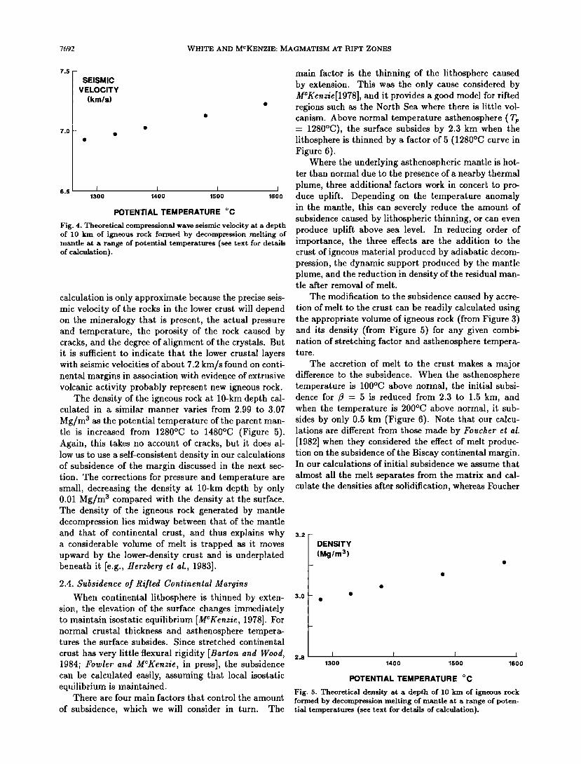
The density of the igneous rock at 10-kin depth cal- culated in a similar manner varies from 2.99 to 3.07
Mg/m 3 as the potential temperature of the parent man- tle is increased from 1280øC to 1480øC (Figure 5). Again, this takes no account of cracks, but it does al- low us to use a self-consistent density in our calculations of subsidence of the margin discussed in the next sec- tion. The corrections for pressure and temperature are small, decreasing the density at 10-km depth by only 0.01 Mg/m 3 compared with the density at the surface. The density of the igneous rock generated by mantle decompression lies midway between that of the mantle and that of continental crust, and thus explains why a considerable volume of melt is trapped as it moves upward by the lower-density crust and is underplated beneath it [e.g., Herzberg et at., 1983].
2.4. Subsidence of Rifted Continental Margins
When continental lithosphere is thinned by exten- sion, the elevation of the surface changes immediately to maintain isostatic equilibrium [MCKenzie, 1978]. For normal crustal thickness and asthenosphere tempera- tures the surface subsides. Since stretched continental
crust has very little flexural rigidity [Barton and Wood, 1984; Fowler and MCKenzie, in press], the subsidence can be calculated easily, assuming that local isostatic equilibrium is maintained.
There are four main factors that control the amount
of subsidence, which we will consider in turn. The
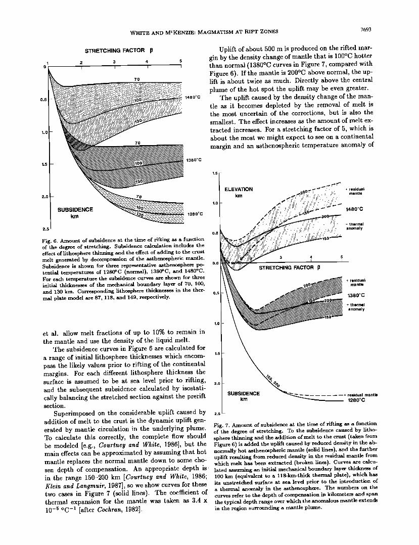
main factor is the thinning of the lithosphere caused by extension. This was the only cause considered by MCKenzie[1978], and it provides a good model for rifted regions such as the North Sea where there is little vol- canism. Above normal temperature asthenosphere (Tp = 1280øC), the surface subsides by 2.3 km when the lithosphere is thinned by a factor of 5 (1280øC curve in Figure 6).
Where the underlying asthenospheric mantle is hot- ter than normal due to the presence of a nearby thermal plume, three additional factors work in concert to pro- duce uplift. Depending on the temperature anomaly in the mantle, this can severely reduce the amount of subsidence caused by lithospheric thinning, or can even produce uplift above sea level. In reducing order of importance, the three effects are the addition to the crust of igneous material produced by adiabatic decom- pression, the dynamic support produced by the mantle plume, and the reduction in density of the residual man- tle after removal of melt.
The modification to the subsidence caused by accre- tion of melt to the crust can be readily calculated using the appropriate volume of igneous rock (from Figure 3) and its density (from Figure 5) for any given combi- nation of stretching factor and asthenosphere tempera- ture.
The accretion of melt to the crust makes a major difference to the subsidence. When the asthenosphere temperature is 100øC above normal, the initial subsi- dence for 1• - 5 is reduced from 2.3 to 1.5 km, and when the temperature is 200øC above normal, it sub- sides by only 0.5 km (Figure 6). Note that our calcu- lations are different from those made by Foucher et al. [1982] when they considered the effect of melt produc- tion on the subsidence of the Biscay continental margin. In our calculations of initial subsidence we assume that
almost all the melt separates from the matrix and cal- culate the densities after solidification, whereas Foucher
3.2
3.0
DENSITY
(Mg/m 3)
1300 1400 1500 1600
POTENTIAL TEMPERATURE Oc
Fig. 5. Theoretical density at a depth of 10 km of igneous rock formed by decompression melting of mantle at a range of poten- tial temperatures (see text for details of calculation).
WHITE AND MCKENZIE: MAGMATISM AT RIFT ZONES 7693
STRETCHING FACTOR p
3 4 5
7O
0.5
1.0
1.5
7O
1480øC
Uplift of about 500 m is produced on the rifted mar- gin by the density change of mantle that is 100øC hotter than normal (1380øC curves in Figure 7, compared with Figure 6). If the mantle is 200øC above normal, the up- lift is about twice as much. Directly above the central plume of the hot spot the uplift may be even greater.
The uplift caused by the density change of the man- tle as it becomes depleted by the removal of melt is the most uncertain of the corrections, but is also the smallest. The effect increases as the amount of melt ex- tracted increases. For a stretching factor of 5, which is about the most we might expect to see on a continental margin and an asthenospheric temperature anomaly of
1380øC
2.0
2.5
70
SUBSIDENCE km 1280øC
,.5[ ELEVATION
km
0.5
Fig. 6. Amount of subsidence at the time of rifting as a function of the degree of stretching. Subsidence calculation includes the effect of lithosphere thinning and the effect of adding to the crust melt generated by decompression of the asthenospheric mantle.
0.0 Subsidence is shown for three representative asthenosphere po- tential temperatures of 1280øC (normal), 1380øC, and 1480øC. For each temperature the subsidence curves are shown for three initial thicknesses of the mechanical boundary layer of 70, 100, and 130 kin. Corresponding lithosphere thicknesses in the ther- 0.s mat plate model are 87, 118, and 149, respectively.
3 4 5
STRETCHING FACTOR
residual
1480øC
+ residual mantle
1380øC
+ thermal
anomaly
et al. allow melt fractions of up to 10% to remain in the mantle and use the density of the liquid melt.
The subsidence curves in Figure 6 are calculated for a range of initial lithosphere thicknesses which encom- pass the likely values prior to rifting of the continental margins. For each different lithosphere thickness the surface is assumed to be at sea level prior to rifting, and the subsequent subsidence calculated by isostati- cally balancing the stretched section against the prerift section.
Superimposed on the considerable uplift caused by addition of melt to the crust is the dynamic uplift gen- erated by mantle circulation in the underlying plume. To calculate this correctly, the complete flow should be modeled [e.g., Courthey and White, 1986], but the main effects can be approximated by assuming that hot mantle replaces the normal mantle down to some cho-
1.0
1.5
2.0
SUBSIDENCE + residual mantle km 1280oc
2.5 --
Fig. 7. Amount of subsidence at the time of rifting as a function of the degree of stretching. To the subsidence caused by litho- sphere thinning and the addition of melt to the crust (taken from Figure 6) is added the uplift caused by reduced density in the ab- normally hot asthenospheric mantle (solid lines), and the further uplift resulting from reduced density in the residual mantle from which melt has been extracted (broken lines). Curves are calcu-
sen depth of compensation. An appropriate depth is, lated assuming an initial mechanical boundary layer thickness of in the range 150-200 km [Courthey and White, 1986; 100 km (equivalent to a 118-km-thick thermal plate), which has Klein and Langmuir, 1987], so we show curves for these its unstretched surface at sea levd prior to the introduction of two cases in Figure 7 (solid lines) The coefficient of a thermal anomaly in the asthenosphere. The numbers on the ' curves refer to the depth of compensation in kilometers and span thermal expansion for the mantle was taken as 3.4 x the typical depth range over which the anomalous mantle extends 10 -s øC-• [after Cochran, 1982]. in the region surrounding a mantle plume.
7694 WHITE AND MCKENZIE: MAGMATISM AT RIFT ZONES
100øC, the additional uplift caused by mantle depletion is about 350 m (broken lines, Figure 7). When the tem- perature anomaly is 200øC, the uplift is about 500 m. For lower amounts of stretching the effect is smaller (Figure 7). In principle it is possible to calculate the composition of the residual mantle left after removal of any desired amount of partial melt, and hence to de- rive the density of the residual mantle [Bickle, 1986]. But in practice the uncertainties in the mineralogy at depth make this an unreliable method for small melt fractions, and we have adopted the simpler method fol- lowed by Klein and Langmuir [1987] of using the den- sity difference between lherzolite and residual harzbur- gite [Oxburgh and Parmentier, 1977] as indicative of the density changes to be expected.
In our subsidence calculations we have ignored the density decrease of the crustal rocks caused by heating from the newly intruded melt. We have also neglected the density decrease of the igneous rocks that results from their initially high temperatures. Both these ef- fects would tend to reduce still further the initial subsi-
dence shown in Figure 7. Elevated temperatures in the lower crust would be lost by conduction on a timescale of a few to 10 million years, so the reduced densities re- sulting from high temperatures would only be effective in the initial stages of rifting.
We conclude that relatively small temperature in- creases in the asthenospheric mantle have a dramatic effect on the initial subsidence of rifted basins and
continental margins. For typical ranges of lithosphere thicknesses and compensation depths, a temperature in- crease of 100-150øC above normal causes the surface to
remain near to or above sea level as the region rifts (Fig- ure 7). Continental uplift has often been reported prior to rifting [e.g., Le Bas, 1971; Kinsman, 1975]. As we shall see in section 3, the majority of the volcanic rocks found on rifted continental margins were erupted sub- aerially. The main rift may be elevated so much that the basalt generated by mantle decompression is able to flow out laterally and downhill over huge regions to generate extensive areas of flood basalts on the adjacent continents.
Once a continental margin has ceased rifting and a new oceanic spreading center has developed, the mar- gin will begin to subside thermally in a normal manner for the amount of stretching as the underlying astheno- sphere cools.
2.5. Pure or Simple Shear?
There has been much debate about the possibility that in extensional regions there may be major detach- ment faults extending through the crust and possibly through the entire lithosphere which allow the upper crust to thin in one location whilst transferring the ma- jor lithospheric thinning laterally to another [e.g., Bally, 1981; Wernicke, 1985]. There are two major conse- quences of this idea: first, the crustal rifting and sub-
sidence may be very different on the two sides of a de- veloping oceanic rift; second, the magmatism caused by decompression of upwelling asthenosphere may be off- set laterally from the main region of crustal thinning [Bosworth, 1987]. The rift basins formed in continen- tal crust are often asymmetric [Bally, 1981; Bosworth, 1985; Klitgord et al., 1988], and detachment faulting has been invoked to explain the asymmetry [Lister et al., 1986], the variabihty in the basins along the East Coast U.S. continental margin [Klitgord et al., 1988], the crustal thinning on the Biscay continental margin [Le Pichon and Barbier, 1987], and the exposure of mantle rocks on the Iberian margin [Boillot et al., 1987].
In our model we assume that stretching the litho- sphere results in uniform thinning (pure shear), and cal- culate the melt produced accordingly. This approach is justified because we are dealing with the large quan- tities of melt generated by extreme thinning of the lithosphere, where the ultimate break to a new oceanic spreading center occurs in the same location as the ma- jor thinning. The minor, but nevertheless widespread syn-rift volcanism that commonly accompanies the ini- tial stages of intra-continental rifting is likely to re- flect localized thinning and asymmetric stretching and may well be asymmetrically distributed [e.g., Bosworth, 1987]. But the large volumes of melt with which we are concerned will be produced close to the location of the ultimate break to fully igneous oceanic crust.
In general, the transition from normal thickness con- tinental crust to oceanic crust occurs over a relatively short distance, typically 50-80 km, on volcanic rifted margins [White et al., 1987b; Mutter et al., 1988]. The transition on nonvolcanic margins such as the Bay of Biscay margin is often over a greater width. We at- tribute this to the weakening effect of large quantities of hot intruded igneous rock: once the lithosphere has started to rift this will weaken it considerably in the re- gion of greatest thinning. We also note in passing that it is difficult to define a precise "continent-ocean bound- ary" in the heavily intruded region of faulted, thinned continental crust, where there are possibly disaggre- gated continental blocks in a matrix of young igneous rock [White, 1987].
2.6. Comparison With Other Models of Riff Magmatism
It may be useful to draw out some of the differ- ences between our model for rift magmatism and some of some of those proposed by others, although this is by no means intended to be a detailed critique of other models.
The model of melt generation by passive astheno- sphere upwelling under rifting continental lithosphere proposed by Foucher et al. [1982] comes closest to our model, although they only considered stretching above normal temperature asthenosphere such as is found on the Biscay margin. They did not consider rifting above
WHITE AND MCKENZIE: MAGMATISM AT RIFT ZONES 7695
abnormally hot asthenosphere which generates volumi- nous magmatism. In detail, they used a simpler an- alytic expression for melt generation as a function of pressure and temperature, and they assumed that up to 10% liquid melt remains in the matrix in their cal- culation of subsidence, in contrast to our belief that almost all of the melt migrates upward rapidly. Fur- long and Fountain [1986] suggested that 10-15 km of crustal underplating could be seen in high seismic ve- locity lower crust, but they argued that the high seismic velocities were caused by phase changes rather than by compositional changes as in our model.
Hot spots have long been considered as a source of weakness in the lithosphere which controls the location of subsequent rifting [e.g., Hyndman, 1973; Kinsman, 1975; Morgan, 1981, 1983]. We have no particular rea- son to believe that the location of oceanic rifts is con-
trolled solely by hot spots as in $pohn and $chubert's [1982] model, or in Sengot and Burke's [1978] "active mantle hypothesis," since there are examples of hot spots without subsequent rifting and many other exam- ples of continental rifting away from the influence of any known hot spots. Nevertheless, if a hot spot is present prior to rifting, it will cause considerable uplift, of the order of i km or more across a 1500 to 2000-km broad
region. This provides significant gravitational potential which will greatly assist rifting across the region. The difference between the contribution from the elevation
and the earlier notions of the effects of hot spots on con- tinental rifting is largely one of scale: the 2000-km-wide thermal anomaly generates stresses across a broad re- gion, whilst earlier authors were thinking only in terms of the localized thermal effects beneath the rift itself.
Sometimes the onset of continental breakup may be caused directly by the initiation of a new mantle plume. In other cases the plume may have existed for some time but rifting may not start until the plate has moved across the plume to a place where the plate can be bro- ken.
Once rifting does occur across the mushroom head thermal anomaly around a mantle plume, then we ex- pect it to modify the continental margins by producing extensive magmatism along the rifted margins with a thick volcanic ridge such as the Iceland-Faeroes Ridge or the Walvis Ridge directly above the central plume itself. Note that our model is different from that pro- posed by Vink [1984], who suggested that not only was the Iceland-Faeroes Ridge produced by melt fed from the central hot spot plume, but also that the marginal Voring Plateau to the north was fed directly from the plume. We do not believe that Vink's suggestion is correct because we can show that passive upwelling of the mushroom head of hot asthenosphere is adequate to explain the igneous section not only under the V0ring Plateau, but also along the entire 2000-km-long vol- canic margin of the northern North Atlantic [White et al., 1987b; White, 1988a]. The central mantle plume is only about 150 km in diameter, and it is not possible
to move melt generated in that central plume laterally 1000 km before extruding it.
A rather different model to explain volcanic conti- nental margins which requires no increase in the tem- perature of the asthenosphere has been proposed by Mutter et al. [1988]. They suggest that small-scale con- vection beneath the rift will locally enhance the melt generation. The controlling factor in their models as to whether or not small-scale convection commences is
the sharpness of the lithosphere break. Beneath the V0ring Plateau they believe that the continental litho- sphere breaks almost vertically and so promotes small- scale convection whilst the broader stretched transition
on the Biscay margin does not trigger small-scale con- vection.
In our model it is unnecessary to propose that small- scale convection occurs to enhance melt production be- cause sufficient melt is produced by passive upwelling of hot asthenosphere, and there is such an obvious correla- tion between magmatism on the rifted margins and the extent of the thermal anomaly in the mantle from ad- jacent mantle plumes. This correlation is documented from rifted margins around the world in the second half of this paper. The relatively sharp break in the conti- nental crust on volcanic margins commented upon by Mutter et al. [1988] may be a natural consequence of the weakening caused by heavy igneous intrusion, rather than a prima facie cause of the magmatism. Several other observations on volcanic margins are also at vari- ance with Mutter et al's model, such as the gross asym- metry of the conjugate Hatton Bank and east Green- land volcanic margins [White et al., 1987b; Larsen and Jakobsdottir, 1988], the extreme rapidity of melt pro- duction documented from some volcanic margins and flood basalts, and the presence of continental crust be- neath the seaward dipping reflectors.
2.7. Summary of the Mantle Plume- Lithosphere Rifling Model
Our model is intended to explain the presence of vo- luminous magmatic activity on some continental mar- gins, producing thick intrusive and extrusive igneous sections on the rifted margins and sometimes extensive flood basalts on the adjacent continents. The main un- certainty in calculating the volume of partial melt that is generated comes from uncertainty in the latent heat of melting, which is taken to be 3.8 x 10⁵ J/kg. This uncertainty may cause errors of up to 20øC in the deter- mination of the asthenosphere temperature. The partial melt calculations are least certain for small melt frac-
tions because not only are experimental data sparse, but the uncertainty in the small amount of melt left in the matrix will affect how much melt reaches the
crust. However, this is not a severe problem because it is unlikely that more than 1% of melt remains in the mantle, and in any case our main objective is to explain the production of massive quantities of melt for which our calculations are reliable.
7696 WHITE AND MCKENZIE: MAGMATISM AT RIFT ZONES
The main events in the development of a volcanic margin are as follows. 1. A mantle plume, which may initiate abruptly, forms
a mushroom-shaped anomMy of hot mantle beneath un- broken continental lithosphere. The thermal anomaly extends across a 1000 to 2000-km diameter region and reaches typically 100-200øC. Dynamic uplift of up to 1000-2000 m accompanies the hot spot. The thermal anomaly is especially large at the onset of a plume. 2. If the continental lithosphere rifts across the thermal anomaly created by the hot spot, passively upwelling asthenosphere generates large quantities of partial melt by decompression as it rises to fill the space created by the thinning lithosphere. The melt segregates quickly and rises upward until is accreted to the overlying crust. Part of the melt penetrates to the surface to produce voluminous basaltic flows; the remainder is accreted be- neath or intruded into the thinned continental crust.
3. As melt is added to the crust and the parent mantle becomes depleted, the uplift of the surface remains large to maintain isostatic equilibrium. Most of the basaltic section is likely to be erupted subaerially from an ele- vated region above the rift and flows laterally away from the rift onto the adjacent continent. 4. Once the continental lithosphere has been thinned
by a factor in excess of about 5, it breaks completely to generate a new oceanic spreading center. If the rift has passed across, or near to the central mantle plume, as often seems to be the case, huge quantities of melt generated in the upwelling mantle plume are fed directly to the surface and create a 15 to 30-km thick igneous ridge across the opening ocean (such as the Iceland- Faeroes Ridge or the Walvis Ridge).
5. Subsequent to breakup, the volcanic continental margins exhibit rates of thermal subsidence that are appropriate for the amount of lithosphere thinning they have undergone as the elevated asthenosphere beneath them cools. However, unlike nonvolcanic margins, their thermal subsidence commences from near or above sea
level rather than from greater depths, so they remain abnormally shallow. 6. The thickness of the oceanic crust not directly above
the mantle plume generated following breakup is often less than the maximum thickness of the igneous section on the adjacent volcanic rifted margins, although it still remains greater than normal. This reduction in igneous production may be attributed partly to a decrease in ex- cess asthenospheric mantle temperature resulting from the enormous loss of heat advected out of the mantle by melt generated in the central plume once breakup has occurred and the melt is able to bleed to the surface.
It may also be due to breakup shortly after the initia- tion of a mantle plume, because transient anomalously high temperatures are produced across a wide area by the initial mantle blob which heralds the onset of a new
plume. The breakup of the North Atlantic, for example, was probably triggered by the initiation of the Iceland plume [White, 1989].
3. VOLCANIC CONTINENTAL MARGINS
AND FLOODBASALTS
3.1. Worldwide Distribution
Thick outpourings of volcanic rock have been iden- tified on rifted continental margins around the world (Figure 1). Minor synrift volcanism has been found on almost all rifted continental margins, but our main in- terest in this paper is in those margins with unusually voluminous magmatism. Many of the regions of exten- sive volcanism on rifted margins were first identified by Hinz [1981]. Others have been added by Mutter et al. [1988] and by numerous other local sources which we discuss further in the context of each individual area.
In the following sections we discuss in detail the de- velopment of the various rift margins where voluminous magmatism has been found. We start with the north- ern North Atlantic, which is perhaps the best exam- ple of the interaction of a developing oceanic rift with the thermal anomaly created by a mantle plume. The North Atlantic is a good example because both margins of the basin have been widely studied on land and at sea, there is little sediment to obscure the deep struc- ture, and the timing of the igneous events is reason- ably well controlled. Other regions we shall discuss are progressively less well documented, sometimes owing to their geographical setting, which means that the for- merly conjugate margin is no longer available for study (vide the west Australian margin), sometimes because the deep structure is obscured by thick overlying sedi- ments, and often because only reconnaissance work has so far been undertaken.
The distribution of voluminous continental flood
basalts will be discussed along with the rift margin which was responsible for the melt generation. In Table 2 we list the major flood basalt provinces, together with their extents and ages. The Columbia River basalts are included for completeness, though rifting has not there continued to develop an oceanic spreading center. The volumes of the extrusive rocks in individual flood basalt
provinces reach 2.5 million km 3. The dating of individ- ual provinces is quite variable for two distinct reasons. First, minor early and late volcanic events tend to cause a wide spread in overall ages of a province and perhaps are preferentially sampled because they tend to be in- teresting petrologically. The volumetrically important basaltic flows are often much less densely sampled in proportion to their volume and so have relatively fewer age determinations. Second, radiometric dating tech- niques are subject to all the well-known sources of er- ror, both from experimental technique and from geo- logical effects such as reheating or loss of one of the radiogenic components. Potassium-argon dating is par- ticularly difficult for these basalts because they contain so little K20. In Table 2 we have tried to give not only the span of dates for each province but also the best estimates, where they exist, of the age and duration of the peak of volcanic activity.

WHITE AND MCKENZIE: MAGMATISM AT RIFT ZONES 7697
TABLE 2. Major Flood Basalts and Continental Breakup
Ocean Basin Onset of Seafloor Igneous Province Spreading, Ma
(Magnetic Chron)
Flood Basalts
Age Span, (Main Age) Duration, Area, (Ma) Ma m.y. x1000 km 2
North Atlantic 58-56 a British Tert. Ig. Prov. 63-52 b (59) c 2-3 d 500 (24r) East Greenland 57-53 e,! ~ 3! 54g
West Greenland 62-53 b (58-54) h 3-4 d 55 i
South Atlantic 130-117 Paran• 130-120 k (~ 120) l '1 to a few 'm 1200 m (M9-M4)J Etendeka 128-113 n (~ 120) ø 2 n 15 p
Indian Ocean- 64 Deccan 67-60 r (66) s • 0.5 s > 1000t, u Seychelles (27r) q
Red Sea- Ethiopian Flood basalts 30-15 (~ 25) v 'most intense at 750" Gulf of Aden Aden and Yemen traps 29-20 (~ 27) w'x earlier time'"
Gondwana Karoo 200-175 (193) y 'a few m.y. 'z > 150 z Breakup Antarctic 179-16288'bv
Columbia River 17-6 cc (17-13.5) cc <3.5 m.y. cc 200 c•
aAnomaly 24r, Berggren et al. [1985] time scale (Hatland et al. [1982] give 56-53 for 24r) time scale. VFrom compilation in Figure 10. CMussett et al. [1988]. dThis paper. ½Noble et al. [1988]. ! Berggren et al. [1985]. • Clarke and Pederson [1976]. hThis paper after Clarke and Upton [1971], Klose et al. [1981], Srivastava [1983], Rolle [1985]. i Clarke and Pedersen [1976]. 3Anomaly identifications from Austin and Uchupi [1982]. M9-M4 time from Hartand et al. [1982] (130-127 Ma); van Hinte [1976] (126-122 Ma), and Larson and Hilde [1975] (121-117 Ma). • Cordant et al. [1980]. l A raaral et al. [1966]. mBellieni et al. [1984]. n128-113 Ma [Siedner and Mitchell, 1976]. OErlank et al. [1984]. P Eales et al. [1984]. q Schlich [1982]. r Courtillot et al. [1986]. s Courtillot and Cisowski [1987]. t Pascoe [1964]. u Deshraukh [1982]. "ohr [1983]. w Civetta ei al. [1978]. x Moseley [1970]. Y Fi•ch and Miller [1984]. ZEales et al. [1984]. aa Scrutton [1973]. bbBehrendt et al. [1980]; Ford and Kistler [1980]. CCHooper [1982].
In general, the main peak of volcanism often occurs near the beginning of a volcanically active period, of- ten just a few million years after the onset of igneous activity. The flood basalts often overlie, are interca- lated with, or are overlain by subaerial or freshwater sediments. This indicates their subaerial origin. There are often indications of regional uplift prior to the ef- fusive volcanism. Where the timing of the start of rapid seafloor spreading is good, it can be seen that the peak of igneous activity is coincident with the on- set of spreading (Table 2; see also section 4). These
relative timings are consistent with our model of melt generation. Details of the relative timing of uplift, of continental separation, and of igneous activity provide a crucial test of our hot spot rifting model, so we dis- cuss the timing in detail in the sections that follow.
3.2. Identification of Igneous Rocks on Seismic Profiles
Before commencing our survey of magmatism on continental margins, we shall discuss the criteria by which we identify extrusive and intrusive igneous rocks
7698 WHITE AND MCKENZIE: MAGMATISM AT RIFT ZONES
on the margins. On land there is little difficulty in map- ping the extent of the volcanic rocks other than in es- timating how much has been lost by erosion, or is ob- scured by sediment or by ice cover. Under water it is quite a different matter, as there has been very little direct sampling and we must rely on indirect methods such as seismic reflection profiling, wide-angle seismic velocity determinations, and gravity or magnetic map- ping.
Although it has been known for a long time that lo- calized synrift volcanism often accompanies the breakup of continents, it is only recently that it has been realized that some margins exhibit very considerable igneous ac- tivity [e.g., Hinz, 1981; Roberts et al., 1984b; White et al., 1987b; White, 1988a]. The presence of large quan- tities of volcanic rocks on some margins was first pos- tulated by Hinz [1981], who suggested that characteris- tic patterns of seaward dipping reflectors seen on many seismic reflection profiles were caused by thick extrusive basaltic flows. Since seismic profiles only give the shape of reflectors and not the composition of the rocks, this conclusion was just one interpretation, and others held that the dipping reflectors were mainly sedimentary deltaic deposits [e.g., Roberts et al., 1979]. However, direct sampling by drilling of seaward dipping reflec- tors on the Rockall and Norwegian margins has shown that they are indeed composed of basaltic rocks as pos- tulated by Hinz [Roberts el al., 1984a, b; Eldholm el al., 1986; ODP Leg 10• Scientific Party, 1986; Parson et al., 1985]. Detailed seismic velocity measurements using wide-angle profiles have confirmed that the dip- ping reflectors exhibit seismic velocities characteristic of volcanic rocks and too high for sedimentary deposits [Mutter et al., 1984; White et al., 1987b; Whirmarsh and Miles, 1987; Spence et al., 1989].
Once it has been accepted that seaward dipping re- flectors are caused by volcanic flows, it is easy to map the distribution of volcanism along continental mar- gins where good seismic profiling exists. Care must still be taken, however, not to interpret automatically any package of reflectors that dips seaward as neces- sarily caused by volcanic flows. For example, Klitgord et al. [1988] show a series of planar dipping reflectors on United States Geological Survey line 28 across the southern Baltimore Canyon Trough on the U.S. con- tinental shelf which are interpreted as volcaniclastic sedimentary wedges. Volcanic flow dipping reflectors, by contrast, generally exhibit convex upward curvature with dips that increase in a seaward direction.
Similar dipping patterns seen in piles of basalt flows on land in Iceland have been explained by Pallmason [1980] as due to the loading effects of flows fed from a retreating vent. By analogy, Mutter et al. [1982] sug- gested that the seaward dipping reflectors on the Norwe- gian margin were formed by "subaerial seafloor spread- ing," a phrase also used by Smythe [1983] in describ- ing similar reflectors on the Faeroes continental margin.
The flow direction of the basalts was toward the land
from vents retreating oceanward which later developed into oceanic spreading centers: thus reflector sequences dipping in the opposite geographic direction should be, and indeed are, found on the conjugate margin which lay on the opposite side of the rift, [e.g., see White et al., 1987b; Larsen and Jakobsdottir, 1988].
The seaward dipping reflectors have often been used as an indication of where the continent-ocean boundary is to be defined. Different authors, however, have de- fined the continent-ocean boundary as lying at a wide range of different positions with respect to the dipping reflector wedge. Definitions range from the landward margin of the wedge, through a position midway be- neath it, to one at the seaward edge. We believe that much (though not all) of the extrusive volcanic wedge is underlain by heavily intruded and stretched pre-existing continental crust. It then becomes a matter of seman-
tics whether to call the isolated blocks of continental
crust in a matrix of new igneous material a "continen- tal" or an "oceanic" crust. It is better not to expect to define a precise point which is the "continent-ocean boundary."
Recent detailed wide-angle seismic experiments on rifted continental margins in the North Atlantic have shown that accompanying the extruded basalts which form the seaward dipping reflectors there is an even greater volume of new underplated or intruded igneous rock in the lower crust [e.g., White et al., 1987b; Mutter et al., 1988]. As we have shown in section 2, we expect these lower crustal igneous rocks to exhibit seismic ve- locities of around 7.2 km/s, and so we should look for velocities of this type on rift margins that we suspect have been affected by a mantle plume. However, al- though high-velocity lower crustal rocks are caused by magmatism related to continental breakup, their pres- ence is not sufficient evidence on its own, since un- stretched continental crust can sometimes exhibit sim-
ilar high seismic velocities [e.g., Meissner, 1986]. It is only where the adjacent unstretched continental crust does not have a high-velocity layer that high velocities developed on the margins can be attributed with confi- dence to igneous accretion.
3.3. The northern North Atlantic and
the Tertiary Igneous Province
This region includes the northern Labrador Sea, the Greenland-Norwegian Basin, and the Iceland Sea, all of which were opened in the early Tertiary by the spread- ing of Greenland away from northwest Europe, and North America away from Greenland. The Tertiary ig- neous province of Britain, northern Ireland, the Faeroes and Greenland was formed at the same time and is also
related to rifting above the thermal anomaly surround- ing the mantle plume which is now beneath Iceland. Rifting during the Mesozoic opened a series of sedimen- tary basins off northwest Europe, such as the More and
WHITE AND MCKENZIE: MAGMATISM AT RIFT ZONES 7699
2000
NORTH ATLANTIC 2øøø
0 500 1000 i
km
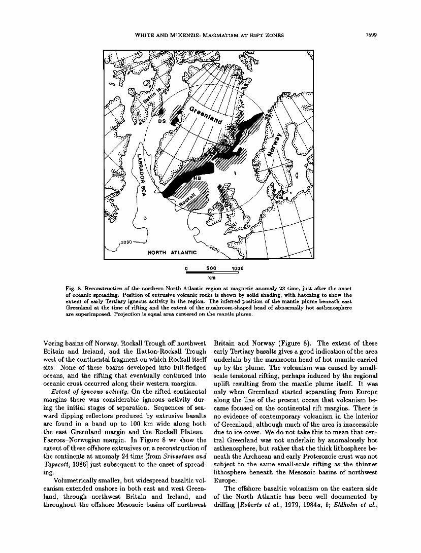
Fig. 8. Reconstruction of the northern North Atlantic region at magnetic anomaly 23 time, just after the onset of oceanic spreading. Position of extrusive volcanic rocks is shown by solid shading, with hatching to show the extent of early Tertiary igneous activity in the region. The inferred position of the mantle plume beneath east Greenland at the time of rifting and the extent of the nmshroom-shaped head of abnormally hot asthenosphere are superimposed. Projection is equal area centered on the mantle plume.
Voring basins off Norway, Rockall Trough off northwest Britain and Ireland, and the Hatton-Rockall Trough west of the continental fragment on which Rockall itself sits. None of these basins developed into full-fledged oceans, and the rifting that eventually continued into oceanic crust occurred along their western margins.
Extent of igneous activity. On the rifted continental margins there was considerable igneous activity dur- ing the initial stages of separation. Sequences of sea- ward dipping reflectors produced by extrusive basalts are found in a band up to 100 km wide along both the east Greenland margin and the Rockall Plateau- Faeroes-Norwegian margin. In Figure 8 we show the extent of these offshore extrusives on a reconstruction of
the continents at anomaly 24 time [from Srivastava and Tapscott, 1986] just subsequent to the onset of spread- ing.
Volumetrically smaller, but widespread basaltic vol- canism extended onshore in both east and west Green-
land, through northwest Britain and Ireland, and throughout the offshore Mesozoic basins off northwest
Britain and Norway (Figure 8). The extent of these early Tertiary basalts gives a good indication of the area underlain by the mushroom head of hot mantle carried up by the plume. The volcanism was caused by small- scale tensional rifting, perhaps induced by the regional uplift resulting from the mantle plume itself. It was only when Greenland started separating from Europe along the line of the present ocean that volcanism be- came focused on the continental rift margins. There is no evidence of contemporary volcanism in the interior of Greenland, although much of the area is inaccessible due to ice cover. We do not take this to mean that cen-
tral Greenland was not underlain by anomalously hot asthenosphere, but rather that the thick lithosphere be- neath the Archaean and early Proterozoic crust was not subject to the same small-scale rifting as the thinner lithosphere beneath the Mesozoic basins of northwest Europe.
The offshore basaltic volcanism on the eastern side
of the North Atlantic has been well documented by drilling [Roberts et al., 1979, 1984a, b; Eldholm et al.,
7700 WHITE AND MCKENZIE: MAGMATISM AT RIFT ZONES
HATTON-ROCKALL HATTON ICELAND LINE BASIN BANK BASIN
SE a 4.0 A B C D E F G H NW 0 I ß water ß ß ß ß ß ß ß ß •- ......... water •:.•:.•::•.!•:•:•...:i:•:i•7•.:.•:.•.:..:::•.•:!•:•?:.•:::•:•..•:•::•:•:•:•:•:::• -• ß ""'•"•' "••...-••'...::':.":'• .... . .5.•. 5.0 -...-. -. - •---•_•wa.•.er
"' s•.'• •' ..... •.•'k' ' ' ': .............. .s._•. .•, • ß ....
?.•s' ' ß . • . ß 6'S •'-:/ • •
20 - •o.o • • . . •/ eo•O 8.07 •' 7.2___•___••
8.1
I HATTON BANK MARGIN 40--
km
VeRING PLATEAU
ROST ESCAR P. NO RW EGIAN
SE 9 SYNCLINE 10 [ 11 12 BASIN 13 NW 0 ß ß ß ß ß ß
I...::.:.:•:::.::..:,...:,:...::..:.::......,...-,..:..:...*.,...-,..:.. ..... ...•.,.,.,...- ......... •.•.......,..,,.....:.• ..................... • , -, ..... ,_.,-.-.,....,.- ...... water '•'"'-'•'-'--"-•-' s-' ., '. ß ...•'•'.'"• "-','•,•,•,•
I: ..•.0":..." ' ..... ' " . ' " ./'•' 7.s- "' ......
20 -
t•o•O
i
J 2 V•RING MARGIN 40 -
0 50 100 V.E. = 2.3x I
km
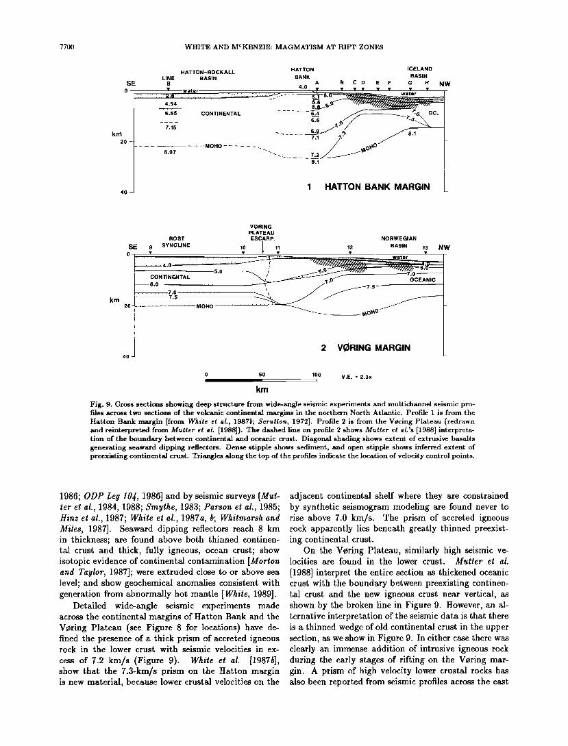
Fig. 9. Cross sections showing deep structure from wide-angle seismic experiments and multichannel seismic pro- files across two sections of the volcanic continental margins in the northern North Atlantic. Profile I is from the Hatton Bank margin [from White et al., 1987b; Scrutton, 1972]. Profile 2 is from the Vcring Plateau (redrawn and reinterpreted from Mutter et aL [1988]). The dashed line on profile 2 shows Mutter et aL's [1988] interpreta- tion of the boundary between continental and oceanic crust. Diagonal shading shows extent of extrusive basalts generating seaward dipping reflectors. Dense stipple shows sediment, and open stipple shows inferred extent of preexisting continental crust. Triangles along the top of the profiles indicate the location of velocity control points.
1986; ODP Leg 10•, 1986] and by seismic surveys [Mul- ler el a!., 1984, 1988; $mylhe, 1983; Parson el a!., 1985; Hinz el a!., 1987; While el a!., 1987a, b; Whilmarsh and Miles, 1987]. Seaward dipping reflectors reach 8 km in thickness; are found above both thinned continen- tal crust and thick, fully igneous, ocean crust; show isotopic evidence of continental contamination [Morton and Taylor, 1987]; were extruded close to or above sea level; and show geochemical anomahes consistent with generation from abnormally hot mantle [While, 1989].
Detailed wide-angle seismic experiments made across the continental margins of Hatton Bank and the V0ring Plateau (see Figure 8 for locations) have de- fined the presence of a thick prism of accreted igneous rock in the lower crust with seismic velocities in ex-
cess of 7.2 km/s (Figure 9). White e! hi. [1987b], show that the 7.3-km/s prism on the Hatton margin is new material, because lower crustal velocities on the
adjacent continental shelf where they are constrained by synthetic seismogram modeling are found never to rise above 7.0 km/s. The prism of accreted igneous rock apparently lies beneath greatly thinned preexist- ing continental crust.
On the Voring Plateau, similarly high seismic ve- locities are found in the lower crust. Muller e! al.
[1988] interpret the entire section as thickened oceanic crust with the boundary between preexisting continen- tal crust and the new igneous crust near vertical, as shown by the broken line in Figure 9. However, an al- ternative interpretation of the seismic data is that there is a thinned wedge of old continental crust in the upper section, as we show in Figure 9. In either case there was clearly an immense addition of intrusive igneous rock during the early stages of rifting on the Voring mar- gin. A prism of high velocity lower crustal rocks has also been reported from seismic profiles across the east
WHITE AND MCKENZIE: MAGMATISM AT RIFT ZONES 7701
Greenland margin [Mutter and Zehnder, 1988], indicat- ing similar igneous additions on the margin conjugate to the V•ring Plateau.
If a wedge of intrusive igneous rock underlies the ex- trusive basalts found elsewhere all along the northern North Atlantic margins, as seems likely, then an enor- mous volume of melt must have been generated during the early rifting stages. We estimate the total volume as up to 10 million km •.
On the east Greenland margin, seaward dipping reflectors are found from the southern tip of Green- land northward along the entire coast [Larsen, 1984; Roberts ½t al., 1984a; Parson et al., 1985; Hinz et al., 1987; Uruski and Parson, 1985]. Offshore the extru- sive basalts attain similar thicknesses to those found
on the conjugate European margin [Larsen and Jakob- sdottir, 1988]. The onshore tholeiitic plateau basalts reach 6 to 7-km in thickness in the vicinity of Kangerd- lugssuaq [Larsen, 1984]. They thin landward and were extruded from sources to seaward that were parallel to the present coast [Noble et al., 1988]: this coincides with the axis of continental rifting. Gabbroic plutons in Skaergaard, in Kap Edvard Holm, and farther south in the Kialineq complex continue the earlier tholeiitic basic magmatism. The onshore basalts were extruded over shallow marine and freshwater sediments and re-
mained above sea level during most of their formation [Larsen, 1984].
Along the west Greenland coast, no evidence is found of extensive volcanism associated with the rift-
ing of the southern Labrador Sea, until one is as far north as the Davis Strait. There is then a large area of basaltic volcanism covering an area of 55,000 km • on west Greenland around Svartenhuk Halve, Ubekendt Ejland, Nfigssuaq, and Disko Island [Clarke and Peder- sen, 1976], of the same age and of similar composition to that found 700 km away in east Greenland. These basalts reach 8-km thickness in places [Denham, 1974]. They were extruded over shallow-marine or freshwater sediments and extend offshore as seaward dipping layers [Park et al., 1971; Ross and Henderson, 1973]. Almost identical basalts are found on Cape Dyer, Baflin Island on the conjugate margin [Clarke, 1970; Clarke and Up- ton, 1971]. The Cape Dyer basalts were also extruded over terrestrial sediments from an offshore source and
are now tilted seaward. The picritic and olivine-rich compositions [Clarke and Upton, 1971] are typical of melt formed by decompression of anomalously hot thenospheric mantle.
The crust of Baffin Bay, the northward continuation of the Labrador Sea, is oceanic [tfeen and Barrett, 1973] and was formed by continental rifting about the same time as the northern North Atlantic. It is abnormally shallow, as is the northern North Atlantic, again in- dicative of formation in the vicinity of a mantle plume. The shallow Davis Strait has very thick crust reaching 20 km, and could be either heavily intruded stretched
continental crust [Manderscheid, 1980], or abnormally thick oceanic crust [Keen and Barrett, 1973; $rivasiava, 1983]. Both the extensive volcanism and the elevation at the time of rifting can be explained by our model of thinning above anomalously hot asthenosphere pro- duced by the mantle plume then under east Greenland (Figure 8). In contrast, Morgan [1983] postulated the presence of a separate mantle plume centered under the Davis Strait, and $rivasiava [1983] considered that be- cause the lavas of both east and west Greenland thin
toward central Greenland, they could not be caused by the same plume.
We believe that one single plume under east Green- land was responsible for bringing to the base of the plate the hot asthenosphere that caused excessive vol- canism off both east and west Greenland, but that vol- canism only occurred when the overlying lithosphere was actually stretched and thinned. The opening of the Labrador Sea is thus a crucial test of our model. As
we show in the next section, the Labrador Sea com- menced opening in the south at about 75 Ma [$rivas- iava, 1978] when the hot spot was absent. It did not therefore produce any rift-margin volcanism, and the margins and newly formed oceanic crust subsided to normal depths. But as the rift extended northward into Baffin Bay at around 60 Ma, it intersected the hot as- thenosphere mushroom either because the hot spot had migrated southward or, more likely, because the hot spot had only then been initiated. Extensive volcanism was then produced onshore and offshore in the vicinity of the stretched and thinned lithosphere, and the newly formed margins and oceanic crust were formed and re- mained anomalously shallow [Hyndman, 1973, 1975].
The remaining area of excessive volcanism in the North Atlantic is Iceland itself, with its 15-kin-thick crust and the Greenland-Iceland-Faeroes Ridge, where the crustal thickness reaches 35 km [Boli and Gunnars- son, 1980]. The ridge lay above the central mantle plume and so was fed by the considerable quantities of partial melt produced within the upwelling mantle. Lat- erally, the crustal thickness decreases down the spread- ing center of the Reykjanes Ridge, although the pres- ence of abnormally hot asthenosphere is indicated by anomalous seismic velocities in the upper mantle close to Iceland [Ritzerl and jacoby, 1985], by the anoma- lously shallow seafloor [Haigh, 1973], by the rather thicker than normal oceanic crust generated along the Reykjanes Ridge [Bunch and Kennell, 1980; While el al., 1987b] and by geochemical anomalies in the basalts formed at the spreading center [Klein and Langmuir, 1987].
Timing of igneous activity. The timing of basaltic volcanism in the North Atlantic and Baffin Bay regions shows that it is tied closely to the onset of oceanic spreading. There are three distinct methods of dat- ing the volcanism, namely, radiometric dating, identi- fication of magnetic anomaly reversals, and biostrati-
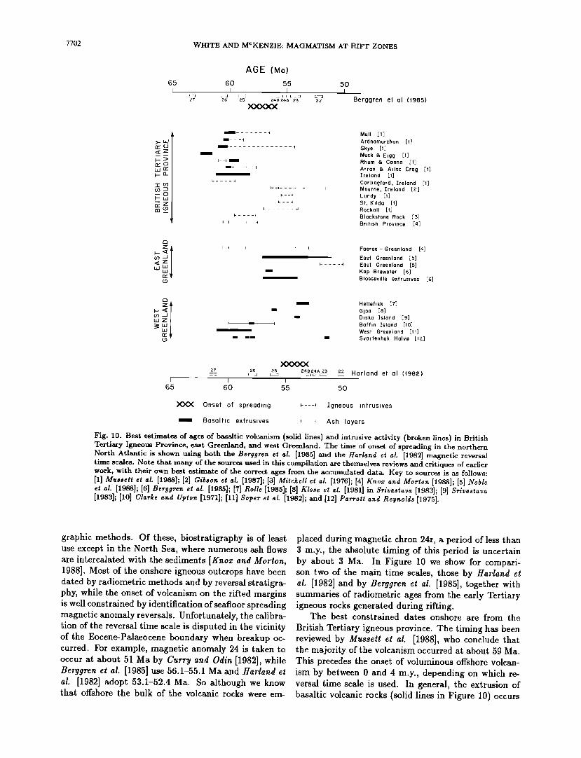
7702 WHITE AND MCKENZIE: MAGMATISM AT RIFT ZONES
65
AGE (Ma)
60 55 50 I I I
26 24B 24A 23 22 Berggren et al (1985)
rr'C)
o• wO• •o_
I .......
I---
I
I--i I
I ..... 4
Mull [1]
Ardnamurchan [1] Skye Muck I• Eigg [1] Rhum I• Canna [1]
Arran I• Alisa Crag [1] Ireland [1]
Carlingford, Ireland [1] Mourne, Ireland [2] Lundy [1] St. KiIda Rockall [t]
Blackstone Rock British Province [4]
Faeroe - Greenland [4]
East Greenland [5] East Greenland [5] Kap Brewster [6] Biosseville extruslves [6]
Helleflsk [7]
Gloa [8] Disko Island [9] Baffln Island [10] West Greenland Svartenhuk Halve [lZ]
27 2G 2L•5 24B24A 2• 22 Harmand et am (1982)
65 60 55 50
XXX Onset of spreading F---• Igneous intrusives
m Basaltic extrusives i .... • Ash layers
Fig. 10. Best estimates of ages of basaltic volcanism (solid lines) and intrusive activity (broken lines) in British Tertiary Igneous Province, east Greenland, and west Greenland. The time of onset of spreading in the northern North Atlantic is shown using both the Berggren et al. [1985] and the Hatland et al. [1982] magnetic reversal time scales. Note that many of the sources used in this compilation are themselves reviews and critiques of earher work, with their own best estimate of the correct ages from the accumulated data. Key to sources is as follows: [1] Musseft et al. [1988]; [2] Gibson et al. [1987]; [3] Mitchell et al. [1976]; [4] Knox and Morton [1988]; [S] Noble et al. [1988]; [6] Berggren et al. [1985]; [7] nolle [1985]; [8] Ix'lose et al. [1981] in Srivastava [1983]; [9] Srivastava [1983]; [10] Clarke and Upton [1971]; [11] Soper et al. [1982]; and [12] Parroft and
graphic methods. Of these, biostratigraphy is of least use except in the North Sea, where numerous ash flows are intercalated with the sediments [Knox and Morton, 1988]. Most of the onshore igneous outcrops have been dated by radiometric methods and by reversal stratigra- phy, while the onset of volcanism on the rifted margins is well constrained by identification of seafloor spreading magnetic anomaly reversals. Unfortunately, the calibra- tion of the reversal time scale is disputed in the vicinity of the Eocene-Palaeocene boundary when breakup oc- curred. For example, magnetic anomaly 24 is taken to occur at about 51 Ma by Curry and Odin [1982], while Berggren et al. [1985] use 56.1-55.1 Ma and Harland et al. [1982] adopt 53.1-52.4 Ma. So although we know that offshore the bulk of the volcanic rocks were em-
placed during magnetic chron 24r, a period of less than 3 m.y., the absolute timing of this period is uncertain by about 3 Ma. In Figure 10 we show for compari- son two of the main time scales, those by Harland et al. [1982] and by Berggren et al. [1985], together with summaries of radiometric ages from the early Tertiary igneous rocks generated during rifting.
The best constrained dates onshore are from the
British Tertiary igneous province. The timing has been reviewed by Musset! e! al. [1988], who conclude that the majority of the volcanism occurred at about 59 Ma. This precedes the onset of voluminous offshore volcan- ism by between 0 and 4 m.y., depending on which re- versal time scale is used. In general, the extrusion of basaltic volcanic rocks (solid lines in Figure 10) occurs
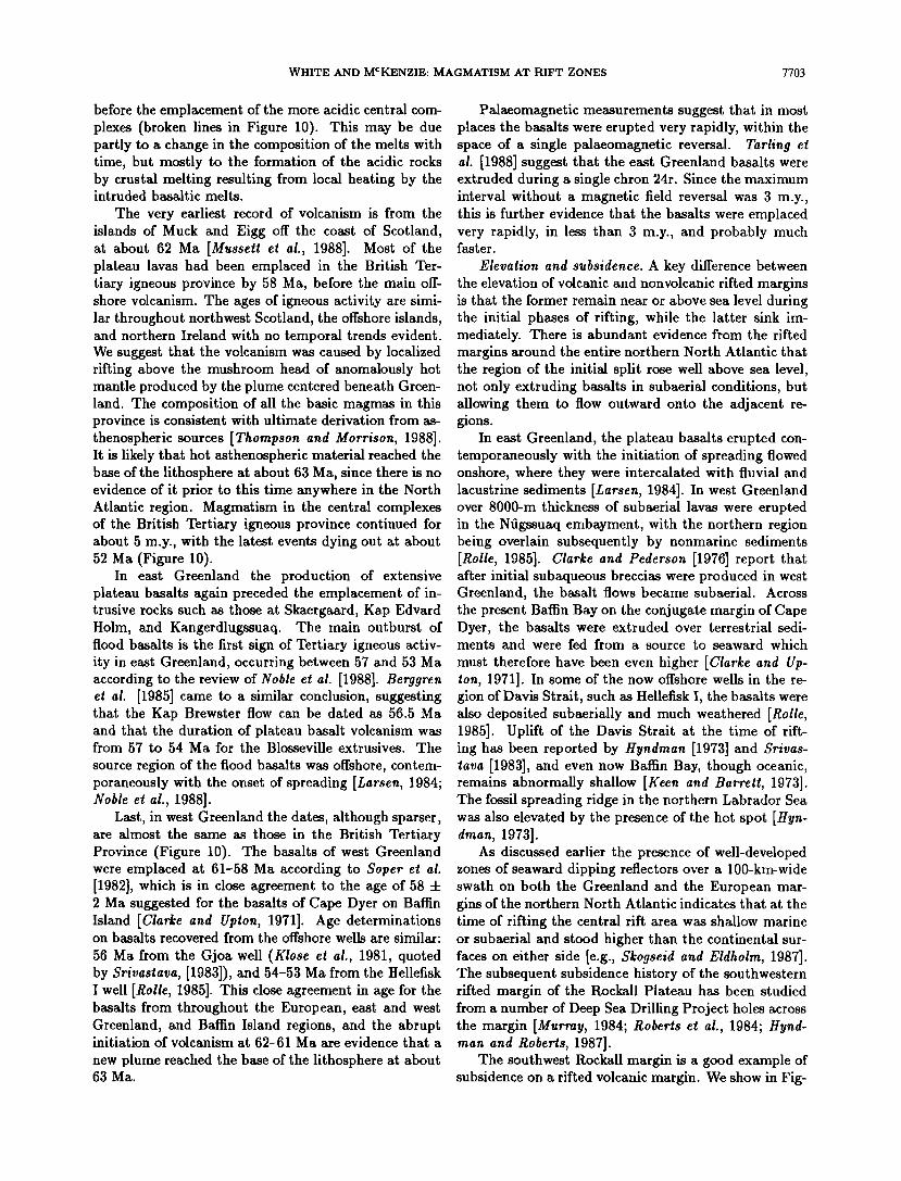
WHITE AND MCKENZIE: MAGMATISM AT RIFT ZONES 7703
before the emplacement of the more acidic central com- plexes (broken lines in Figure 10). This may be due partly to a change in the composition of the melts with time, but mostly to the formation of the acidic rocks by crustal melting resulting from local heating by the intruded basaltic melts.
The very earliest record of volcanism is from the islands of Muck and Eigg off the coast of Scotland, at about 62 Ma [Musseft et al., 1988]. Most of the plateau lavas had been emplaced in the British Ter- tiary igneous province by 58 Ma, before the main off- shore volcanism. The ages of igneous activity are simi- lar throughout northwest Scotland, the offshore islands, and northern Ireland with no temporal trends evident. We suggest that the volcanism was caused by localized rifting above the mushroom head of anomalously hot mantle produced by the plume centered beneath Green- land. The composition of all the basic magmas in this province is consistent with ultimate derivation from as- thenospheric sources [Thompson and Morrison, 1988]. It is likely that hot asthenospheric material reached the base of the lithosphere at about 63 Ma, since there is no evidence of it prior to this time anywhere in the North Atlantic region. Magmatism in the central complexes of the British Tertiary igneous province continued for about 5 m.y., with the latest events dying out at about 52 Ma (Figure 10).
In east Greenland the production of extensive plateau basalts again preceded the emplacement of in- trusive rocks such as those at Skaergaard, Kap Edvard Holm, and Kangerdlugssuaq. The main outburst of flood basalts is the first sign of Tertiary igneous activ- ity in east Greenland, occurring between 57 and 53 Ma according to the review of Noble et al. [1988]. Berggren et al. [1985] came to a similar conclusion, suggesting that the Kap Brewster flow can be dated as 56.5 Ma and that the duration of plateau basalt volcanism was from 57 to 54 Ma for the Biosseville extrusives. The
source region of the flood basalts was offshore, contem- poraneously with the onset of spreading [Larsen, 1984; Noble et al., 1988].
Last, in west Greenland the dates, although sparser, are almost the same as those in the British Tertiary Province (Figure 10). The basalts of west Greenland were emplaced at 61-58 Ma according to Soper et al. [1982], which is in close agreement to the age of 58 4- 2 Ma suggested for the basalts of Cape Dyer on Bariin Island [Clarke and Upton, 1971]. Age determinations on basalts recovered from the offshore wells are similar:
56 Ma from the Gjoa well (Klose et al., 1981, quoted by Srivastava, [1983]), and 54-53 Ma from the Hellefisk I well [Rolle, 1985]. This close agreement in age for the basalts from throughout the European, east and west Greenland, and Bariin Island regions, and the abrupt initiation of volcanism at 62-61 Ma are evidence that a
new plume reached the base of the lithosphere at about 63 Ma.
Palaeomagnetic measurements suggest that in most places the basalts were erupted very rapidly, within the space of a single palaeomagnetic reversal. Tarling et al. [1988] suggest that the east Greenland basalts were extruded during a single chron 24r. Since the maximum interval without a magnetic field reversal was 3 m.y., this is further evidence that the basalts were eraplaced very rapidly, in less than 3 m.y., and probably much faster.
Elevation and subsidence. A key difference between the elevation of volcanic and nonvolcanic rifted margins is that the former remain near or above sea level during the initial phases of rifting, while the latter sink im- mediately. There is abundant evidence from the rifted margins around the entire northern North Atlantic that the region of the initial split rose well above sea level, not only extruding basalts in subaerial conditions, but allowing them to flow outward onto the adjacent re- gions.
In east Greenland, the plateau basalts erupted con- temporaneously with the initiation of spreading flowed onshore, where they were intercalated with fluvial and lacustrine sediments [Larsen, 1984]. In west Greenland over 8000-m thickness of subaerial lavas were erupted in the Nfigssuaq ernbayment, with the northern region being overlain subsequently by nonmarine sediments [ltolle, 1985]. Clarke and Pealerson [1976] report that after initial subaqueous breccias were produced in west Greenland, the basalt flows became subaerial. Across the present Bariin Bay on the conjugate margin of Cape Dyer, the basalts were extruded over terrestrial sedi- ments and were fed from a source to seaward which
must therefore have been even higher [Clarke and Up- ion, 1971]. In some of the now offshore wells in the re- gion of Davis Strait, such as Hellefisk I, the basalts were also deposited subaerially and much weathered [Rolle, 1985]. Uplift of the Davis Strait at the time of rift- ing has been reported by Hyndman [1973] and Srivas- lava [1983], and even now Bariin Bay, though oceanic, remains abnormally shallow [Keen and Barrett, 1973]. The fossil spreading ridge in the northern Labrador Sea was also elevated by the presence of the hot spot [Hyn- dinah, 1973].
As discussed earlier the presence of well-developed zones of seaward dipping reflectors over a 100-kin-wide swath on both the Greenland and the European mar- gins of the northern North Atlantic indicates that at the time of rifting the central rift area was shallow marine or subaerial and stood higher than the continental sur- faces on either side [e.g., $kogseid and Eldholm, 1987]. The subsequent subsidence history of the southwestern rifted margin of the Rockall Plateau has been studied from a number of Deep Sea Drilhng Project holes across the margin [Murray, 1984; Roberts et al., 1984; Hynd- man and Roberts, 1987].
The southwest Rockall margin is a good example of subsidence on a rifted volcanic margin. We show in Fig-
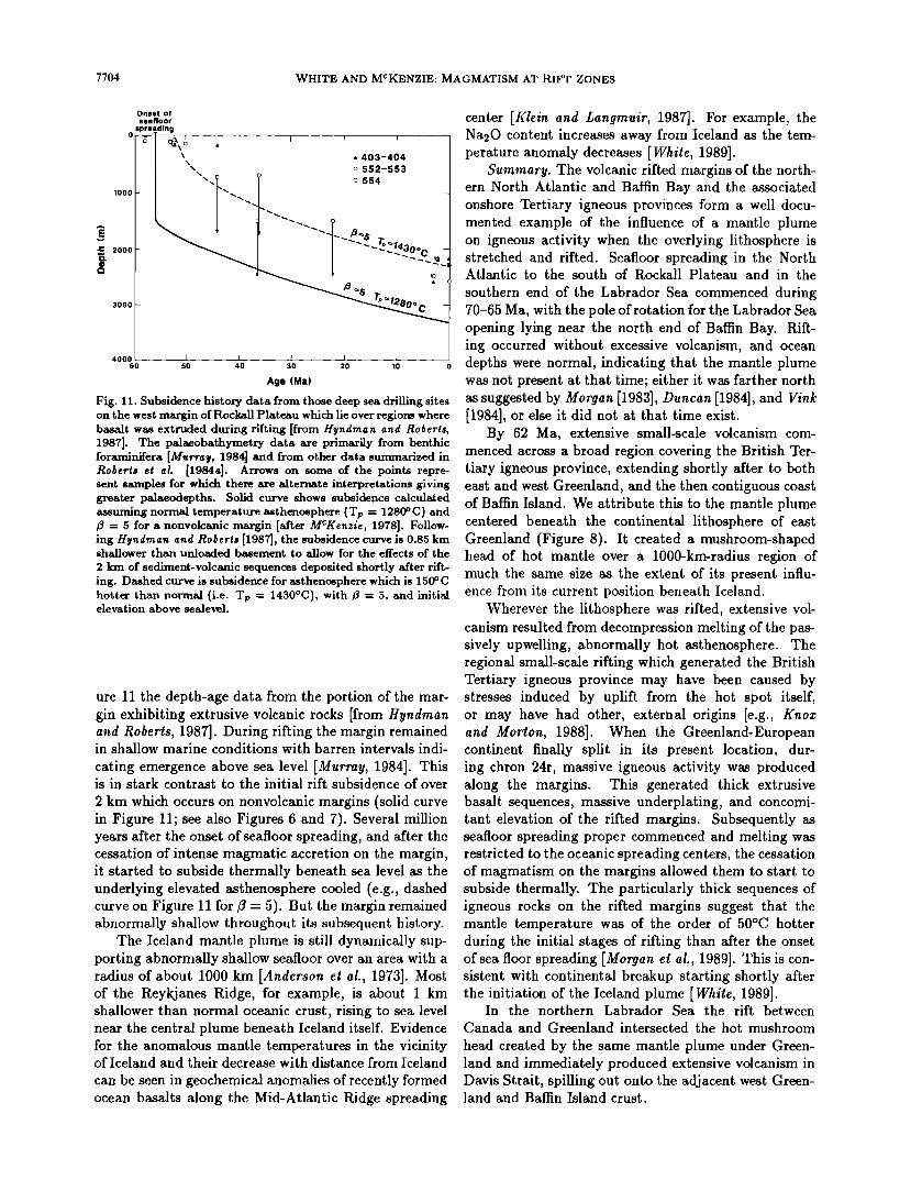
7704 WHITE AND MCKENZIE: MAGMATISM AT RIFT ZONES
Onset of seafloor
sprea_ding
o •l =•=' ß , I I , \• ß 403-404
/ • [] 552-553
/ I
• 2000
3000 -
4000 I I I 60 50 40 30 20 10 0
Age (Ma)
Fig. 11. Subsidence •sto• data from those deep sea drilling sites on the west m•gin of RochH Plat•u whi• lie over regiom where b•t w• ext•ded dgin[ rifting [from Hyn•man 1987]. The p•obathymet• data •e prim•Hy from benthic [or••era [M•rray, 1984] •d from other data su•arized in •04erts et al. [19•a]. Agows on some of the poin• repre- sent s•ples for w• the• ge •te•te inte•retations giving greater pdaeod•ths. So•3 c•ve shows subsidence calculated ass•ng norm• temperathe •th•osph•e (Tp = 128•C) and • = S for a nonvoE•c m•gin [Mt• MCKenzie, 1978]. Follow- ing Hyndman an• R04erts [198?], the subsidence curve is 0.8S km shallower th• •o•e3 b•ement to Eow for the e•ects of the
2 • of se•ment-vo]c•c sequents deposited shortly Mter rift- ing. Dashed cg• is subsidence for •thenmphere whi• is 1S• C hott• th• norad (i.e. Tp = 1430øC), with • = S, and initi• elevation above sewell.
ure 11 the depth-age data from the portion of the mar- gin exhibiting extrusive volcanic rocks [from Hyndman and Roberts, 1987]. During rifting the margin remained in shallow marine conditions with barren intervals indi-
cating emergence above sea level [Murray, 1984]. This is in stark contrast to the initial rift subsidence of over
2 km which occurs on nonvolcanic margins (solid curve in Figure 11; see also Figures 6 and 7). Several million years after the onset of seafloor spreading, and after the cessation of intense magmatic accretion on the margin, it started to subside thermally beneath sea level as the underlying elevated asthenosphere cooled (e.g., dashed curve on Figure 11 for/3 - 5). But the margin remained abnormally shallow throughout its subsequent history.
The Iceland mantle plume is still dynamically sup- porting abnormally shallow seafloor over an area with a radius of about 1000 km [Anderson e! al., 1973]. Most of the Reykjanes Ridge, for example, is about I km shallower than normal oceanic crust, rising to sea level near the central plume beneath Iceland itself. Evidence for the anomalous mantle temperatures in the vicinity of Iceland and their decrease with distance from Iceland
can be seen in geochemical anomalies of recently formed ocean basalts along the Mid-Atlantic Ridge spreading
center [Klein and Langmuir, 1987]. For example, the Na20 content increases away from Iceland as the tem- perature anomaly decreases [White, 1989].
Summary. The volcanic rifted margins of the north- ern North Atlantic and Baffin Bay and the associated onshore Tertiary igneous provinces form a well docu- mented example of the influence of a mantle plume on igneous activity when the overlying lithosphere is stretched and rifted. Seafloor spreading in the North Atlantic to the south of Rockall Plateau and in the
southern end of the Labrador Sea commenced during 70-65 Ma, with the pole of rotation for the Labrador Sea opening lying near the north end of Baffin Bay. Rift- ing occurred without excessive volcanism, and ocean depths were normal, indicating that the mantle plume was not present at that time; either it was farther north as suggested by Morgan [1983], Duncan [1984], and Vink [1984], or else it did not at that time exist.
By 62 Ma, extensive small-scale volcanism com- menced across a broad region covering the British Ter- tiary igneous province, extending shortly after to both east and west Greenland, and the then contiguous coast of Baffin Island. We attribute this to the mantle plume centered beneath the continental lithosphere of east Greenland (Figure 8). It created a mushroom-shaped head of hot mantle over a 1000-krn-radius region of much the same size as the extent of its present influ- ence from its current position beneath Iceland.
Wherever the lithosphere was rifted, extensive vol- canism resulted from decompression melting of the pas- sively upwelling, abnormally hot asthenosphere. The regional small-scale rifting which generated the British Tertiary igneous province may have been caused by stresses induced by uplift from the hot spot itself, or may have had other, external origins [e.g., Knox and Morton, 1988]. When the Greenland-European continent finally split in its present location, dur- ing chron 24r, massive igneous activity was produced along the margins. This generated thick extrusive basalt sequences, massive underplating, and concomi- tant elevation of the rifted margins. Subsequently as seafloor spreading proper commenced and melting was restricted to the oceanic spreading centers, the cessation of magmatism on the margins allowed them to start to subside thermally. The particularly thick sequences of igneous rocks on the rifted margins suggest that the mantle temperature was of the order of 50øC hotter during the initial stages of rifting than after the onset of sea floor spreading [Morgan et al., 1989]. This is con- sistent with continental breakup starting shortly after the initiation of the Iceland plume [White, 1989].
In the northern Labrador Sea the rift between Canada and Greenland intersected the hot mushroom
head created by the same mantle plume under Green- land and immediately produced extensive volcanism in Davis Strait, spilling out onto the adjacent west Green- land and Baffin Island crust.

WHITE AND MCKENZIE: MAGMATISM AT RIFT ZONES 7705
km
ARMORICAN BAY OF
SHELF BISCAY
OBS OBS PUBS PUBS NE L4 JULIE ISIS 2 L2 COB 4 L1 SW
o -. •s..•_•.•. v v v ß v ß -'. ,,., .•;..v ;:-::.::.:::::.•.:'..::.>........
I ß . ß ß .A• .-•' I•1014o .............
•o• 3 BISCAY MARGIN L
w
km
20-
40-
FLEMISH CAP COB GOBAN SPUR E
. ....:... ' •.--:. ': ".•'.'i: .':.:.i.i":':•X.w•..'::i"i'!i. .. '.'i•i'". "' ß " " " '..'.•'•<•'.':'.: • "::" .'.'. •' .'..'.<.'..'.'.'.'-.•:.'.".".•...'..". .'.' " ß ' I ,.._. . .•y w,•, .,-.X ........ < '--". . '-•. . './'. . . ' ' 1.',,'-'-;,' •':. ' :' .......... - ........ '-• ...... '.' '. ß ß '.'.' ...... ./ ' "' '•-•-•--'-'-.- .'.. '.•,.'.'..'.'.'..-•---L .' ß
7-' ß ß ß . '. .' '.' . . '. .' ...... '.'.' _,..•// "x' .'.'.'.' . '.. --.' .' .'.J ' < •.- I %-. ...... / • / •. _ ß '. ' ß '. '. ,• . . . '. ' '.. . . ' ß -•/, x,x...'.'.' .' .•. 'z .L• ..•.' .'..' ,/' - - ß . '._ '•..../ . . :•.'. . :/:./ '4•'• •.' ß •.•-•'.•.•.•.'.:. ' x•._•_'œ ß - ./. •'.' '..' ',' . • 2 •--,//, "-•-- .'. '.-: . . '.'. . : -.
': :' - ':'::': : ':; .... -'-----1 4a Line 85-3 4b WAM L
km
W COB E o
...... "-' ' '••:'""?,•{....,,•.:.... :......,.• ........ ß C0"¾i.,•.'r'^',:'." "':.:•' oc•^.•c ß .
20/. -.-._ ---..•. ' MOHO '.-.•
5 Line 85-2
km
o 50 lOO i
V.E. 2.3x
Fig. 12. Cross sections showing deep structure of the Biscay margin, the Western Approaches margin and New- foundland margins. For locations see Figure 13. Biscay margin (profile 3) is redrawn from Ginzburg et al. [1985]. Western Approaches-Flemish Cap composite llne (profile 4) is redrawn from Keen et al. [1989] Newfoundland margin (profile 5) is from Keen and de Voogd [1988] line 85-2. Key to symbols and scales are the same as for Figure 9.
Once the continental lithosphere had split apart, the melt generated by decompression in the central mantle plume itself was able to extrude freely to the surface to generate the 25- to 35-km-thick igneous crust be- neath the Faeroes Ridge. As the North Atlantic Ocean continued to spread, the central plume generated the ocean-bridging Greenland-Iceland-Faeroes Ridge of ab- normally thick igneous crust. At present the central plume has drifted to a position beneath eastern Iceland where it continues to generate thick igneous crust.
3.4. The Norlh A llanlic
If the archetypal volcanic margins lie in the northern North Atlantic, one of the best examples of a nonvol-
canic rifted margin is found not far to the south, in the Bay of Biscay. The Biscay margin which was formed in the mid-Cretaceous exhibits classic tilted fault blocks
across a broad stretched region [Montaderl el al., 1979]. Across most of the stretched continental margin there is no evidence from the seismic velocity structure or from the deep seismic reflection profiles of any igneous accretion to the lower crust, or volcanic activity in the upper crust [Foucher el al., 1982; Ginzburg el al., 1985; Whdmarsh el al., 1986].
The transition from stretched and thinned continen-
tal crust to fully igneous oceanic crust occurs over a nar- row transition zone (profile 3, Figure 12). Subsidence is rapid at the initial time of rifting and decreases sub-
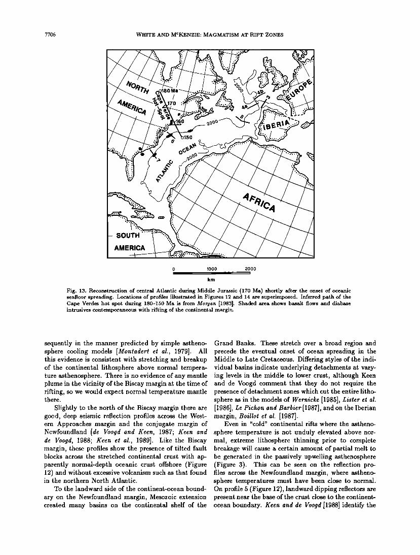
7706 WHITE AND MCKENZIE: MAGMATISM AT RIFT ZONES
SOUTH
AMERICA
o lOOO 2000 -!
km
Fig. 13. Reconstruction of central Atlantic during Middle Jurassic (170 Ma) shortly after the onset of oceanic seafloor spreading. Locations of profiles illustrated in Figures 12 and 14 are superimposed. Inferred path of the Cape Verdes hot spot during 180-150 Ma is from Morgan [1983]. Shaded area shows basalt flows and diabase intrusives contemporaneous with rifting of the continental margin.
sequently in the manner predicted by simple astheno- sphere cooling models [Montader! e! al., 1979]. All this evidence is consistent with stretching and breakup of the continental lithosphere above normal tempera- ture asthenosphere. There is no evidence of any mantle plume in the vicinity of the Biscay margin at the time of rifting, so we would expect normal temperature mantle there.
Slightly to the north of the Biscay margin there are good, deep seismic reflection profiles across the West- ern Approaches margin and the conjugate margin of Newfoundland [de Voogd and Keen, 1987; Keen and de Voogd, 1988; Keen et al., 1989]. Like the Biscay margin, these profiles show the presence of tilted fault blocks across the stretched continental crust with ap- parently normal-depth oceanic crust offshore (Figure 12) and without excessive volcanism such as that found in the northern North Atlantic.
To the landward side of the continent-ocean bound-
ary on the Newfoundland margin, Mesozoic extension created many basins on the continental shelf of the
Grand Banks. These stretch over a broad region and precede the eventual onset of ocean spreading in the Middle to Late Cretaceous. Differing styles of the indi- vidual basins indicate underlying detachments at vary- ing levels in the middle to lower crust, although Keen and de Voogd comment that they do not require the presence of detachment zones which cut the entire litho- sphere as in the models of Wernicke [1985], Lister el al. [1986], Le Pichon and Barbier[1987], and on the Iberian margin, Boillot el al. [1987].
Even in "cold" continental rifts where the astheno-
sphere temperature is not unduly elevated above nor- mal, extreme lithosphere thinning prior to complete breakage will cause a certain amount of partial melt to be generated in the passively upwelling asthenosphere (Figure 3). This can be seen on the reflection pro- files across the Newfoundland margin, where astheno- sphere temperatures must have been close to normal. On profile 5 (Figure 12), landward dipping reflectors are present near the base of the crust close to the continent- ocean boundary. Keen and de Voogd [1988] identify the
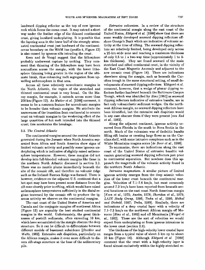
WHITE AND MCKENZIE: MAGMATISM AT RIFT ZONES 7707
landward dipping reflector as the top of new igneous rock which forms the ocean crust. It may extend a short way under the feather edge of the thinned continental crust, giving localized underplating. It is possible that the layering seen in the lower half of the strongly atten- uated continental crust just landward of the continent- ocean boundary on the WAM line (profile 4, Figure 12) is also caused by igneous sills intruding the crust.
Keen and de Voogd suggest that the lithosphere probably underwent rupture by necking. They com- ment that thinning of the lithosphere may have been nonuniform across the margin, with the lower litho- sphere thinning being greater in the region of the ulti- mate break, thus enhancing melt segregation from up- welling asthenosphere in that area.
Across all these relatively nonvolcanic margins in the North Atlantic, the region of the stretched and thinned continental crust is very broad. On the Bis- cay margin, for example, it extends across more than 200 km (Figure 12). As Mutter et at. [1988] comment, it seems to be a common feature for nonvolcanic margins to be broader than volcanic margins. We attribute the narrowness of the transition from continental to oceanic
crust on volcanic margins to the weakening effect of the large quantities of hot melt intruded into the thinned crust; this accelerates the breakage.
3.5. The Central Atlantic
The continental margins around the central Atlantic generated during the Jurassic when North America sep- arated from Africa and South America show signs of limited volcanic activity and possibly some igneous un- derplating which is indicative of slightly raised astheno- sphere temperatures. However, these margins did not develop into full-blooded volcanic margins like those in the northern North Atlantic discussed in section 3.3.
There was no mantle plume immediately beneath the site of the oceanic rift, and therefore no volcanic ridge such as the Iceland-Faeroes Ridge was formed. There is however, evidence on the adjacent U.S. continent that a hot spot may have been present some distance from the rift zone shortly prior to rifting, which would have raised asthenosphere temperatures sufficiently in the distal re- gions traversed by the oceanic rift to produce the ig- neous activity we observe on the continental margins.
The east coast of the United States of America and
Canada and the conjugate margins off northwest Africa (Figure 13) are arguably the best studied continental margins in the world. Unfortunately, the great thick- nesses of postrift sediments, often exceeding 10 km, which have accumulated on the margin obscure the deep structure. So it can be difficult to differentiate between
different models of basement subsidence [$t½ckler and Watts, 1982]. Extensive salt diapirism, particularly on the African margin, makes it even more diflqcult to dis- cern rift-stage structure at the base of the sedimentary pile.
Extrusive volcanism. In a review of the structure
of the continental margin along the east coast of the United States, Klitgord e! al. [1988] show that there are some weakly developed seaward dipping reflectors off- shore George's Bank which are indicative of volcanic ac- tivity at the time of rifting. The seaward dipping reflec- tors are relatively limited, being developed only across a 25-km-wide zone and reaching a maximum thickness of only 0.5 to I s two-way time (approximately I to 3- km thickness). They are found seaward of the main stretched and rifted continental crust, in the vicinity of the East Coast Magnetic Anomaly and adjacent to the new oceanic crust (Figure 14). There are indications elsewhere along the margin, such as beneath the Car- olina trough in the same structural setting, of small de- velopments of seaward dipping reflectors. Klitgord et al. comment, however, that a wedge of planar dipping re- flectors farther landward beneath the Baltimore Canyon Trough, which was identified by Hinz [1981] as seaward dipping reflectors indicative of extrusive basalts, are in fact only volcaniclastic sediment wedges. On the north- west African margin, no seaward dipping reflectors have been identified, but the extensive salt diapirism would in any case obscure them if they were present [von Rad ½t al., 1982].
Along the adjacent continent, igneous activity oc- curred from Florida in the south to Nova Scotia in the
north. Much of the volcanism was of tholeiitic basalts
filling rift basins or creating large flows as on the Car- olina shelf, with some intrusive complexes such as in the White Mountains magma series [de Boer e! al., 1988].
To summarize, there are indications along the east coast of the United States of extrusive basaltic vol-
canism generating seaward dipping reflectors just prior to continental separation. But nowhere does this ap- proach the magnitude of the volcanic activity found in the northern North Atlantic.
Intrusive magmatism. A similar picture of limited igneous activity emerges from the deep seismic veloc- ities of the lower crust beneath the continental mar-
gins. Velocities of 7.1-7.6 km/s, but most commonly around 7.2 km/s have been reported from beneath sev- eral locations on the east coast North American margin [Keen et al., 1975; Ausiin, 1978; Sheridan ½! al., 1979; LASE Study Group, 1986; Trehu et al., 1986; Mirhal and Diebold, 1987; Trehu, 1989]. Similarly, there are indications of a deep crustal layer with a velocity of 7.1-7.3 km/s on the northwest African margin off Mo- rocco [Hinz e! al., 1982] and off Mauritania [ Wetgel e! al., 1982]. These are the sort of velocities we would expect from underplating or from igneous intrusions in the lower crust (section 2.3).
The thickness of the high-velocity lower crustal layer ranges from a typical value of about 5 km up to about 10 km (Figure 14). Although Klitgord e! al. [1988] comment that the crust with a high-velocity layer is found almost exclusively within the highly stretched re-
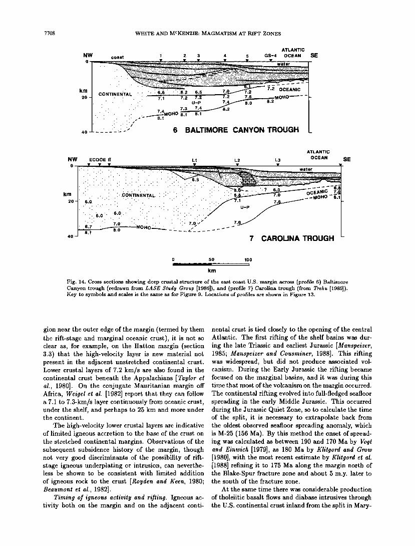
7708 WHITE AND MCKENZIE: MAGMATISM AT RIFT ZONES
ATLANTIC
NW coast 1 2 3 4 5 GS-4 OCEAN SE
' ' ' ..... :':' ........... •..?...:::::::•:•.:•..•.•:;.•:..•:•?::•:...•`:?•.•:•::•?•i•i•::•:•`:i•;•.•ii ........ •' '• -(' "'"' "'. "•:•i:..'•..':.':•:..'•_.'•:'.•;.:;•; ........... . .......... ß 'i ' i" """" ' ' '""":':':::::.:::':::::':.'7.":.::.)::?•!::i:.:::'..>":." ....:.-..•.::•..-.:::.... =============================== .... :..:.::::.:: .... ::.:.v..;: ......
:: CoNklNEN'TAI: ':':' :' :': .:6:6: .: .: .: .6.2. 6.5 ,.?_•.•--'"- 7.z _1 7 2 7.2 /.2 7.5 MOHO•- -I-
:: :: :: i: i: i: i: !: i: i: i: i: .____•_•-.•o.o 7.3 •-4•.2 / .-.' .' .-.-.-.' .-. ß :.:..-" 8.1 8.1 8.1 /
4o ':':':':':':-: :-:>• 6 BALTIMORE CANYON TROUGH L
ATLANTIC
NW ECOOE H L1 L2 L3 OCEAN SE o
km :':':':':':':':':':':':':':':':':':':':':':':':':':':':':-:':':':-:-'..--:<-' "•":':':':':'• 6•_ • ..- ..... 6.8
I.:-.•.'-: .:-:-:-: •.'o.: ::-: :: :_' :' :' :: :: :: :: :: :: :: :: :: •..'oj> • 7.6.•• I l:' :•.7......•0 .... •-•o.o•-;.-::.1.:: -•-C' ....... "- I 4o 8., 7 CAROLINA TROUGH I_
o 50 lOO I
km
Fig. 14. Cross sections showing deep crustal structure of the east coast U.S. margin across (profile 6) Baltimore Canyon trough (redrawn from LASE $•udy Group [1986]), and (profile 7) Carolina trough (from Trehu [1989]). Key to symbols and scales is the same as for Figure 9. Locations of profiles are shown in Figure 13.
gion near the outer edge of the margin (termed by them the rift-stage and marginal oceanic crust), it is not so clear as, for example, on the Hatton margin (section 3.3) that the high-velocity layer is new material not present in the adjacent unstretched continental crust. Lower crustal layers of 7.2 km/s are also found in the continental crust beneath the Appalachians [Taylor et al., 1980]. On the conjugate Mauritanian margin off Africa, Weigel et al. [1982] report that they can follow a 7.1 to 7.3-km/s layer continuously from oceanic crust, under the shelf, and perhaps to 25 km and more under the continent.
The high-velocity lower crustal layers are indicative of limited igneous accretion to the base of the crust on the stretched continental margins. Observations of the subsequent subsidence history of the margin, though not very good discriminants of the possibility of rift- stage igneous underplating or intrusion, can neverthe- less be shown to be consistent with limited addition
of igneous rock to the crust [Royden and Keen, 1980; Beaumont et al., 1982].
Timing of igneous activity and rifling. Igneous ac- tivity both on the margin and on the adjacent conti-
nental crust is tied closely to the opening of the central Atlantic. The first rifting of the shelf basins was dur- ing the late Triassic and earliest Jurassic [Manspeizer, 1985; Manspeizer and Cousininet, 1988]. This rifting was widespread, but did not produce associated vol- canism. During the Early Jurassic the rifting became focused on the marginal basins, and it was during this time that most of the volcanism on the margin occurred. The continental rifting evolved into full-fledged seafloor spreading in the early Middle Jurassic. This occurred during the Jurassic Quiet Zone, so to calculate the time of the split, it is necessary to extrapolate back from the oldest observed seafloor spreading anomaly, which is M-25 (156 Ma). By this method the onset of spread- ing was calculated as between 190 and 170 Ma by Vog! and Einwich [1979], as 180 Ma by Kldgord and Grow [1980], with the most recent estimate by Klitgord e! al. [1988] refining it to 175 Ma along the margin north of the Blake-Spur fracture zone and about 5 m.y. later to the south of the fracture zone.
At the same time there was considerable production of tholeiitic basalt flows and diabase intrusives through the U.S. continental crust inland from the split in Mary-
WHITE AND MCKENZIE: MAGMATISM AT RIFT ZONES 7709
land, Connecticut, New Jersey, and Massachusetts [Sut- ter and Smith, 1979; Puffer et al., 1981; de Boer et al., 1988] (also see Figure 13). The first estimates of the ages of this onshore igneous activity are that there were three main phases, one near 230 Ma, one at 200- 175 Ma, and one at 125-100 Ma [Foland and Faul, 1977; Sutter and Smith, 1979; Sheridan, 1983]. Reevaluation of the geologic sources of imperfect dates, such as ar- gon loss or gain, has led Sutter [1985] to conclude that the most that can be said is that the igneous rocks in the eastern U.S. Mesozoic province appear to have crys- tallized in the general time span of 200-175 Ma. The youngest age igneous rocks, of 125-100 Ma are prob- ably caused by passage beneath New England of the mantle plume which subsequently generated the off- shore chain of New England seamounts [Crough, 1981; Duncan, 1984], and is not of interest to us here, as it postdates continental breakup.
Extensive basalt flows were also produced beneath the present coastal plain and continental shelf landward of the volcanically active Carolina Trough [Behrendt et al., 1983; Hamilton et al., 1983; Schil! et al., 1983]. Their ages are about 185 Ma [Lanphere, 1983], shortly prior to the first seafloor spreading in this area.
The evidence of widespread igneous activity onshore and on the continental shelf during 200-175 Ma over the same time period as the continental margin rifting and volcanism suggests that there was an asthenosphere temperature anomaly across a 1000-km-broad region of the eastern United States. Although igneous activity was widespread, it was not excessive in volume, indi- cating only slightly raised asthenosphere temperatures beneath the site of the continental split. A possible can- didate for a mantle plume which might have generated this broad temperature anomaly is the Cape Verde hot spot. According to Morgan [1983], during 200-175 Ma it would have lain about 1000 km northwest of the east
coast U.S. continental split (Figure 13). We note, how- ever, that this position is not well constrained because Morgan [1983] assumed that different hot spots do not drift with respect to one another, whereas recent work has indicated that they do, albeit at relatively small ve- locities [Molnar and Stock, 1987; Sager and Bleil, 1987]. The large extent of the thermal anomaly surrounding the mantle plume means that the precise location of the plume is not critical to our interpretation, provided it was landward of the present continental margin. Since the rift crossed the distal portion of the mushroom- shaped thermal anomaly, it would cause somewhat en- hanced partial melting in the upwelling asthenosphere beneath stretched lithosphere, but not the massive ig- neous outburst and the volcanic ridges generated in the northern North Atlantic where the split crossed close to the central plume. The widespread broadly contem- poraneous igneous activity indicates the extent of the mantle thermal anomaly. As we predict from our pas- sive asthenosphere upwelling model, most partial melt was generated where the lithosphere was stretched the
most, namely, on the outer edges of the continental mar- gin adjacent to the first oceanic crust.
To summarize, the central North Atlantic margins are an example of a continental split above astheno- sphere that was just a little warmer than normal. The split probably occurred across the distal edge of a re- gion of anomalously hot mantle produced by a distant mantle plume. The resultant magmatism was limited in volume, with most melt being generated in the re- gions adjacent to the ultimate split where lithosphere thinning was greatest.
3.6. The South Atlantic
The opening of the South Atlantic, like that of the northern North Atlantic, is a good example of a con- tinental split which broke right across a mantle plume and its associated thermal anomaly. It generated ex- tensive synrift igneous activity on the conjugate mar- gins of both southern Africa and South America, cre- ated massive volumes of continental flood basalts which
flowed out over the adjacent continents, the Parang in South America which is the most extensive exposed flood basalt in the world (Table 2), and parts of the Karoo in Namibia and southwestern Africa; and built the thick volcanic ridges of the Rio Grande Rise and the Walvis Ridge straddling the ocean basin. The mantle plume responsible for this is still active, at present ly- ing beneath Tristan da Cunha some 300 km east of the Mid-Atlantic Ridge spreading center.
Continental Margins. Seafloor spreading between Africa and South America started in the southern Cape Basin at about the time of anomaly M9 (130 Ma [Harland et al., 1982] 1982 time scale, 126 Ma [van Hinte, 1976] 1976 time scale, or 121 Ma [Larson and Hilde, 1975] 1975 time scale) and propagated northward [Austin and Uchupi, 1982]. Off Walvis Bay, over 1000 km to the north, seafloor spreading did not commence until anomaly M4 time, some 3-5 m.y. later. The onset of seafloor spreading was preceded by a long period of intracontinental rifting of the Precambrian to Permo- Carboniferous granitic, metamorphic, and sedimentary rocks, possibly extending over several tens of millions of years.
Seaward dipping reflectors can be seen on multichan- nel seismic profiles off southwest Africa, reaching thick- nesses in excess of 4 km. They are found in a seaward thickening wedge, which pinches out near the hinge zone at the landward end and extends up to 100 km onto oceanic crust at the seaward end [Austin and Uchupi, 1982]. This wedge of seaward dipping reflectors overlies blocky, probably faulted and rotated continental crust over much of its width. Seaward dipping reflectors have also been reported off the margin of southwest Africa by Hinz [1981] and by Gerrard and Smith [1982], and they probably extend about 1500 km along the eastern margin of the South Atlantic. A large proportion of the Cape Basin dipping reflectors are found landward of anomaly M10 [Hinz, 1981], which suggests that they
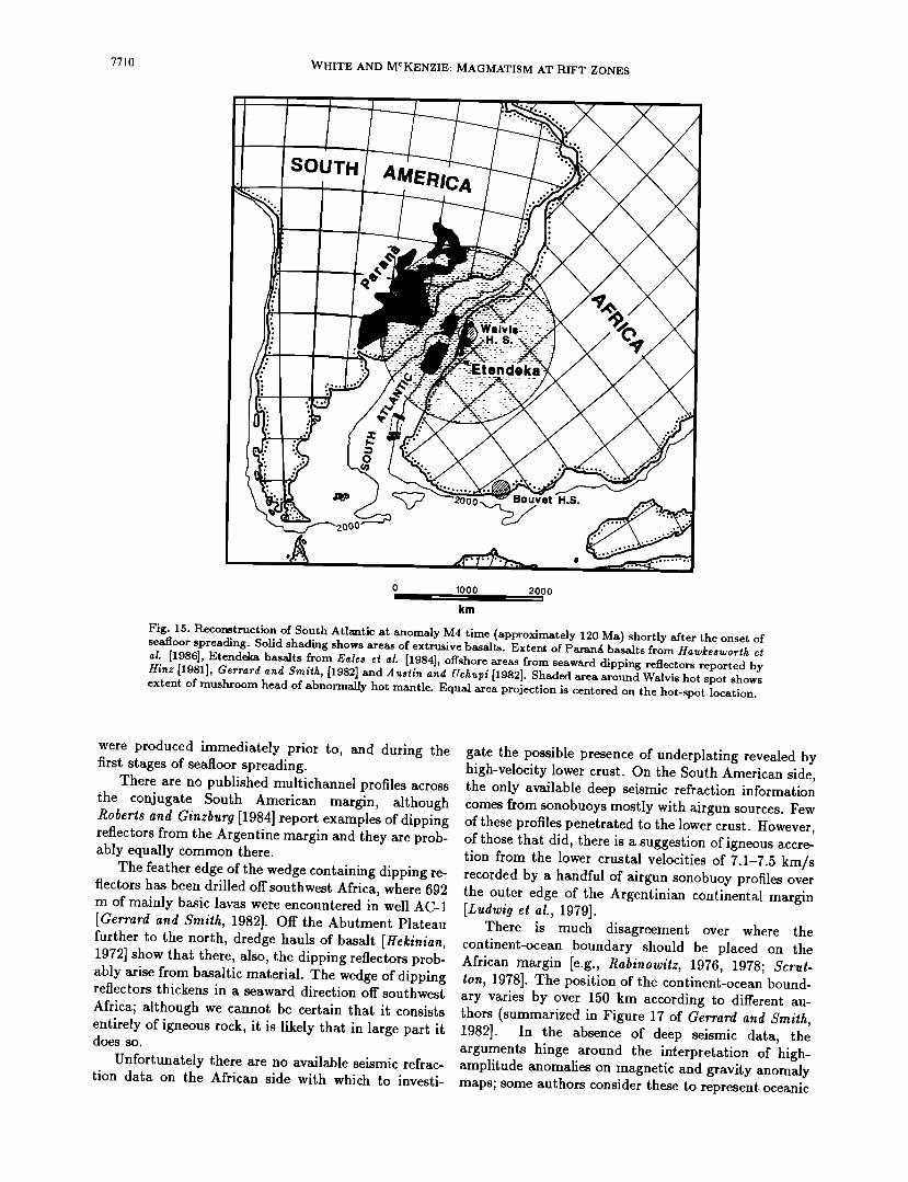
7710 WHITE AND MCKENZIE: MAGMATISM AT RIFT ZONES
SOUTH AMERICA
•Etendeka
uvet H.S.
;)ooo
0 1000 2000
Am
Fig. 15. Reconstruction of South Atlantic at anomaly M4 time (approximately 120 Ma) shortly after the onset of seafloor spreading. Solid shading shows areas of extrusive basalts. Extent of Paran• basalts from Hawkesworth et al. [1986], Etendeka basalts from Eales et al. [1984], off'shore areas from seaward dipping reflectors reported by Hinz [1981], Gerrard and Smith, [1982] and Austin and Uchupi [1982]. Shaded area around Walvis hot spot shows extent of mushroom head of abnormally hot mantle. Equal area projection is centered on the hot-spot location.
were produced immediately prior to, and during the first stages of seafloor spreading.
There are no published multichannel profiles across the conjugate South American margin, although Roberts and Ginzburg [1984] report examples of dipping reflectors from the Argentine margin and they are prob- ably equally common there.
The feather edge of the wedge containing dipping re- flectors has been drilled off southwest Africa, where 692 m of mainly basic lavas were encountered in well AC-1 [Gerrard and Smith, 1982]. Off the Abutment Plateau further to the north, dredge hauls of basalt [Hekinian, 1972] show that there, also, the dipping reflectors prob- ably arise from basaltic material. The wedge of dipping reflectors thickens in a seaward direction off southwest Africa; although we cannot be certain that it consists entirely of igneous rock, it is likely that in large part it does so.
Unfortunately there are no available seismic refrac- tion data on the African side with which to investi-
gate the possible presence of underplating revealed by high-velocity lower crust. On the South American side, the only available deep seismic refraction information comes from sonobuoys mostly with airgun sources. Few of these profiles penetrated to the lower crust. However, of those that did, there is a suggestion of igneous accre- tion from the lower crustal velocities of 7.1-7.5 km/s recorded by a handful of airgun Sohobuoy profiles over the outer edge of the Argentinian continental margin [Ludwig et al., 1979].
There is much disagreement over where the continent-ocean boundary should be placed on the African margin [e.g., Rabinowitz, 1976, 1978; $crut- ton, 1978]. The position of the continent-ocean bound- ary varies by over 150 km according to different au- thors (summarized in Figure 17 of Gerrard and Smith, 1982]. In the absence of deep seismic data, the arguments hinge around the interpretation of high- amplitude anomalies on magnetic and gravity anomaly maps; some authors consider these to represent oceanic
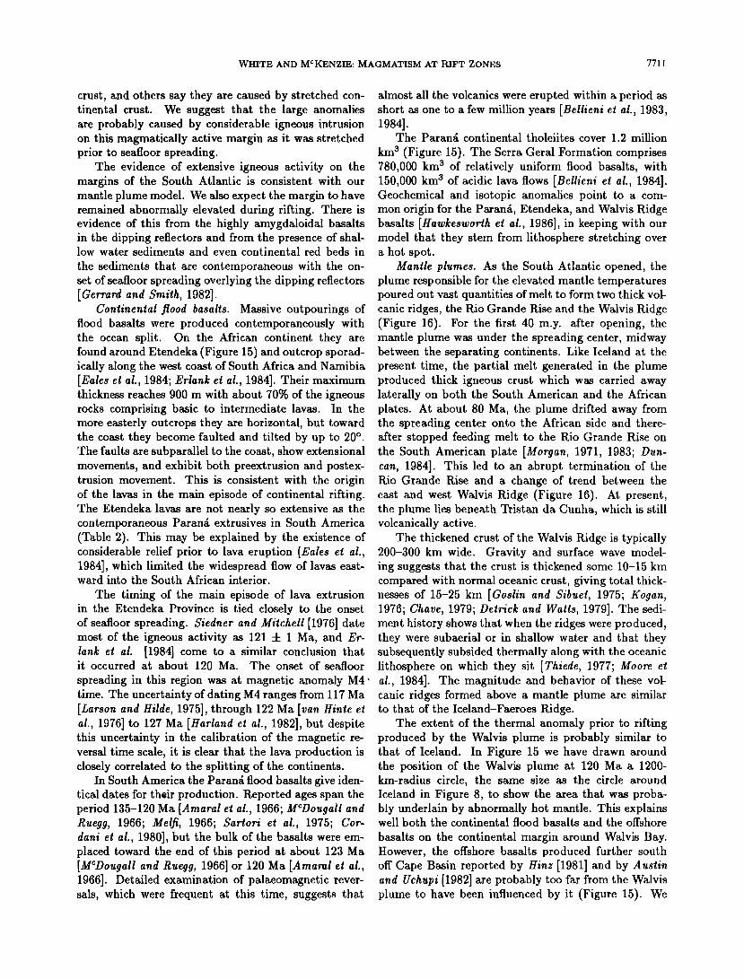
WHITE AND MCKENZIE: MAGMATISM AT RIFT ZONES 77| |
crust, and others say they are caused by stretched con- tinental crust. We suggest that the large anomalies are probably caused by considerable igneous intrusion on this magmatically active margin as it was stretched prior to seafloor spreading.
The evidence of extensive igneous activity on the margins of the South Atlantic is consistent with our mantle plume model. We also expect the margin to have remained abnormally elevated during rifting. There is evidence of this from the highly amygdaloidal basalts in the dipping reflectors and from the presence of shal- low water sediments and even continental red beds in
the sediments that are contemporaneous with the on- set of seafloor spreading overlying the dipping reflectors [Gerrard and Smith, 1982].
Continental flood basalts. Massive outpourings of flood basalts were produced contemporaneously with the ocean split. On the African continent they are found around Etendeka (Figure 15) and outcrop sporad- ically along the west coast of South Africa and Namibia [Eales et al., 1984; Erlank et al., 1984]. Their maximum thickness reaches 900 m with about 70% of the igneous rocks comprising basic to intermediate lavas. In the more easterly outcrops they are horizontal, but toward the coast they become faulted and tilted by up to 20 ø . The faults are subparallel to the coast, show extensional movements, and exhibit both preextrusion and postex- trusion movement. This is consistent with the origin of the lavas in the main episode of continental rifting. The Etendeka lavas are not nearly so extensive as the contemporaneous Parana extrusives in South America (Table 2). This may be explained by the existence of considerable relief prior to lava eruption [Eales et al., 1984], which limited the widespread flow of lavas east- ward into the South African interior.
The timing of the main episode of lava extrusion in the Etendeka Province is tied closely to the onset of seafloor spreading. $iedner and Mitchell [1976] date most of the igneous activity as 121 • i Ma, and Er- lank et al. [1984] come to a similar conclusion that it occurred at about 120 Ma. The onset of seafloor
spreading in this region was at magnetic anomaly M4 ß time. The uncertainty of dating M4 ranges from 117 Ma [Larson and Hilde, 1975], through 122 Ma [van Hinte et al., 1976] to 127 Ma [Harland et al., 1982], but despite this uncertainty in the calibration of the magnetic re- versal time scale, it is clear that the lava production is closely correlated to the splitting of the continents.
In South America the Parana flood basalts give iden- tical dates for their production. Reported ages span the period 135-120 Ma [Amaral et al., 1966; M•Dougall and Ruegg, 1966; Melfi, 1966; Sattort et al., 1975; Cor- dant et al., 1980], but the bulk of the basalts were em- placed toward the end of this period at about 123 Ma [MCDougall and Ruegg, 1966] or 120 Ma [Amaral et al., 1966]. Detailed examination of palaeomagnetic rever- sals, which were frequent at this time, suggests that
almost all the volcanics were erupted within a period as short as one to a few million years [Belltent et al., 1983, 1984].
The Paran• continental tholeiites cover 1.2 million
km a (Figure 15). The Serra Geral Formation comprises 780,000 km a of relatively uniform flood basalts, with 150,000 km s of acidic lava flows [Bellieni et al., 1984]. Geochemical and isotopic anomalies point to a com- mon origin for the Parana, Etendeka, and Walvis Ridge basalts [Hawkesworth et al., 1986], in keeping with our model that they stem from lithosphere stretching over a hot spot.
Mantle plumes. As the South Atlantic opened, the plume responsible for the elevated mantle temperatures poured out vast quantities of melt to form two thick vol- canic ridges, the Rio Grande Rise and the Walvis Ridge (Figure 16). For the first 40 m.y. after opening, the mantle plume was under the spreading center, midway between the separating continents. Like Iceland at the present time, the partial melt generated in the plume produced thick igneous crust which was carried away laterally on both the South American and the African plates. At about 80 Ma, the plume drifted away from the spreading center onto the African side and there- after stopped feeding melt to the Rio Grande Rise on the South American plate [Morgan, 1971, 1983; Dun- can, 1984]. This led to an abrupt termination of the Rio Grande Rise and a change of trend between the east and west Walvis Ridge (Figure 16). At present, the plume lies beneath Tristan da Cunha, which is still volcanically active.
The thickened crust of the Walvis Ridge is typically 200-300 km wide. Gravity and surface wave model- ing suggests that the crust is thickened some 10-15 km compared with normal oceanic crust, giving total thick- nesses of 15-25 km [Goslin and Sibuet, 1975; Kogan, 1976; Chave, 1979; Derrick and Watts, 1979]. The sedi- ment history shows that when the ridges were produced, they were subaerial or in shallow water and that they subsequently subsided thermally along with the oceanic lithosphere on which they sit [Thiede, 1977; Moore e! al., 1984]. The magnitude and behavior of these vol- canic ridges formed above a mantle plume are similar to that of the Iceland-Faeroes Ridge.
The extent of the thermal anomaly prior to rifting produced by the Walvis plume is probably similar to that of Iceland. In Figure 15 we have drawn around the position of the Walvis plume at 120 Ma a 1200- km-radius circle, the same size as the circle around Iceland in Figure 8, to show the area that was proba- bly underlain by abnormally hot mantle. This explains well both the continental flood basalts and the offshore
basalts on the continental margin around Walvis Bay. However, the offshore basalts produced further south off Cape Basin reported by Hinz [1981] and by Austin and Uchupi [1982] are probably too far from the Walvis plume to have been influenced by it (Figure 15). We
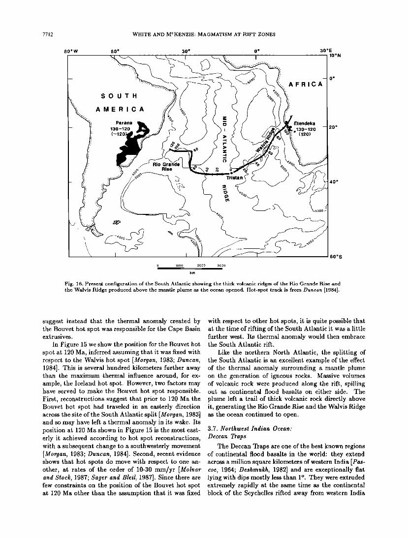
7712 WHITE AND MCKENZIE ß MAGMATISM AT RIFT ZONES
80øW 60 ø 30 ø 0 o
" I I
ß
o, ..
,,,
SOUTH
AMERICA
30øE 10øN
0 o
AFRICA
Parana Etendeka
130-120 o130-120 (---120) (120)
20 ø
Rio Gra
Rise 2 o %0 Tr ista n
0 1000 2000 3000
Am
40"
60øS
Fig. 16. Present configuration of the South Atlantic showing the thick volcanic ridges of the Rio Grande Rise and the Walvis Ridge produced above the mantle plume as the ocean opened. Hot-spot track is from Duncan [1984].
suggest instead that the thermal anomaly created by the Bouvet hot spot was responsible for the Cape Basin extrusives.
In Figure 15 we show the position for the Bouvet hot spot at 120 Ma, inferred assuming that it was fixed with respect to the Walvis hot spot [Morgan, 1983; Duncan, 1984]. This is several hundred kilometers further away than the maximum thermal influence around, for ex- ample, the Iceland hot spot. However, two factors may have served to make the Bouvet hot spot responsible. First, reconstructions suggest that prior to 120 Ma the Bouvet hot spot had traveled in an easterly direction across the site of the South Atlantic split [Morgan, 1983] and so may have left a thermal anomaly in its wake. Its position at 120 Ma shown in Figure 15 is the most east- erly it achieved according to hot spot reconstructions, with a subsequent change to a southwesterly movement [Morgan, 1983; Duncan, 1984]. Second, recent evidence shows that hot spots do move with respect to one an- other, at rates of the order of 10-30 mm/yr [Molnar and Stock, 1987; Sager and Bleil, 1987]. Since there are few constraints on the position of the Bouvet hot spot at 120 Ma other than the assumption that it was fixed
with respect to other hot spots, it is quite possible that at the time of rifting of the South Atlantic it was a little further west. Its thermal anomaly would then embrace the South Atlantic rift.
Like the northern North Atlantic, the splitting of the South Atlantic is an excellent example of the effect of the thermal anomaly surrounding a mantle plume on the generation of igneous rocks. Massive volumes of volcanic rock were produced along the rift, spilling out as continental flood basalts on either side. The
plume left a trail of thick volcanic rock directly above it, generating the Rio Grande Rise and the Walvis Ridge as the ocean continued to open.
3.7. Northwest Indian Ocean:
Deccan Traps
The Deccan Traps are one of the best known regions of continental flood basalts in the world: they extend across a million square kilometers of western India [Pas- coe, 1964; Deshmukh, 1982] and are exceptionally fiat lying with dips mostly less than 1 ø . They were extruded extremely rapidly at the same time as the continental block of the Seychelles rifted away from western India
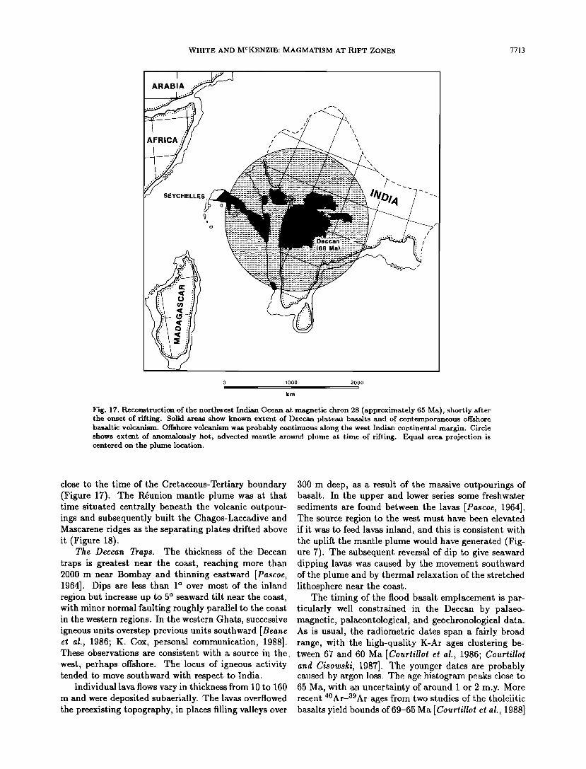
WHITE AND MCKENZIE: MAGMATISM AT RIFT ZONES 7713
I
AFRICA :..• ß
SEYCHELLES
/ \
/ •\ /
•000•
1000 2000
km
Fig. 17. Reconstruction of the northwest Indian Ocean at magnetic chron 28 (approximately 65 Ma), shortly after the onset of rifting. Solid areas show known extent of Deccan plateau basalts and of contemporaneous offshore basaltic volcanism. Offshore volcanism was probably continuous along the west Indian continental margin. Circle shows extent of anomalously hot, advected mantle around plume at time of rifting. Equal area projection is centered on the plume location.
close to the time of the Cretaceous-Tertiary boundary (Figure 17). The l•union mantle plume was at that time situated centrally beneath the volcanic outpour- ings and subsequently built the Chagos-Laccadive and Mascarene ridges as the separating plates drifted above it (Figure 18).
The Deccan Traps. The thickness of the Deccan traps is greatest near the coast, reaching more than 2000 m near Bombay and thinning eastward [Pascoe, 1964]. Dips are less than 1 ø over most of the inland region but increase up to 5 ø seaward tilt near the coast, with minor normal faulting roughly parallel to the coast in the western regions. In the western Ghats, successive igneous units overstep previous units southward [Beane et al., 1986; K. Cox, personal communication, 1988]. These observations are consistent with a source in the
west, perhaps offshore. The locus of igneous activity tended to move southward with respect to India.
Individual lava flows vary in thickness from 10 to 160 m and were deposited subaerially. The lavas overflowed the preexisting topography, in places filling valleys over
300 m deep, as a result of the massive outpourings of basalt. In the upper and lower series some freshwater sediments are found between the lavas [Pascoe, 1964]. The source region to the west must have been elevated if it was to feed lavas inland, and this is consistent with the uplift the mantle plume would have generated (Fig- ure 7). The subsequent reversal of dip to give seaward dipping lavas was caused by the movement southward of the plume and by thermal relaxation of the stretched lithosphere near the coast.
The timing of the flood basalt emplacement is par- ticularly well constrained in the Deccan by palaeo- magnetic, palaeontological, and geochronological data. As is usual, the radiometric dates span a fairly broad range, with the high-quality K-Ar ages clustering be- tween 67 and 60 Ma [Courtillot et al., 1986; Courtillot and Cisowski, 1987]. The younger dates are probably caused by argon loss. The age histogram peaks close to 65 Ma, with an uncertainty of around 1 or 2 m.y. More recent 4øAr-a9Ar ages from two studies of the tholeiitic basalts yield bounds of 69-65 Ma [Courtillot et al., 1988]
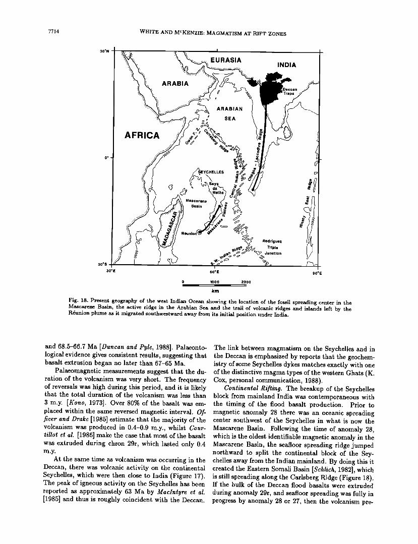
7714 WHITE AND MCKENZIE: MAGMATISM AT RIFT ZONES
30øN
ARABIA
EURASIA INDIA
30øS
30øE
AFRICA
ARABIAN
SEA
Rodriguez
Triple Junction
90øE
0 1000 2000
km
Fig. 18. Present geography of the west Indian Ocean showing the location of the fossil spreading center in the Mascaxene Basin, the active ridge in the Arabian Sea and the trail of volcanic ridges and islands left by the R4union plume as it migrated southwestward away from its initial position under India.
and 68.5-66.7 Ma [Duncan and Pyle, 1988]. Palaeonto- logical evidence gives consistent results, suggesting that basalt extrusion began no later than 67-65 Ma.
Palaeomagnetic measurements suggest that the du- ration of the volcanism was very short. The frequency of reversals was high during this period, and it is likely that the total duration of the volcanism was less than 3 m.y. [Kono, 1973]. Over 80% of the basalt was em- placed within the same reversed magnetic interval. Of- ricer and Drake [1985] estimate that the majority of the volcanism was produced in 0.4-0.9 m.y., whilst Cour- tillot e! ai. [1986] make the case that most of the basalt was extruded during chron 29r, which lasted only 0.4
At the same time as volcanism was occurring in the Deccan, there was volcanic activity on the continental Seychelles, which were then close to India (Figure 17). The peak of igneous activity on the Seychelles has been reported as approximately 63 Ma by MacIntyre et al. [1985] and thus is roughly coincident with the Deccan.
The link between magmatism on the Seychelles and in the Deccan is emphasized by reports that the geochem- istry of some Seychelles dykes matches exactly with one of the distinctive magma types of the western Ghats (K. Cox, personal communication, 1988).
Continental Rifling. The breakup of the Seychelles block from mainland India was contemporaneous with the timing of the flood basalt production. Prior to magnetic anomaly 28 there was an oceanic spreading center southwest of the Seychelles in what is now the Mascarene Basin. Following the time of anomaly 28, which is the oldest identifiable magnetic anomaly in the Mascarene Basin, the seafloor spreading ridge jumped northward to split the continental block of the Sey- chelles away from the Indian mainland. By doing this it created the Eastern Somali Basin [Schlich, 1982], which is still spreading along the Carlsberg Ridge (Figure 18). If the bulk of the Deccan flood basalts were extruded during anomaly 29r, and seafloor spreading was fully in progress by anomaly 28 or 27, then the volcanism pre-
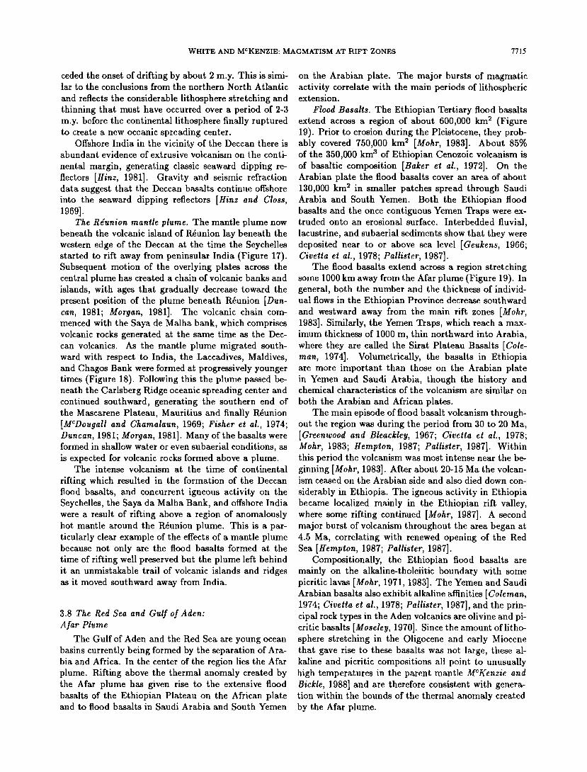
WHITE AND MCKENZIE: MAGMATISM AT RIFT ZONES 7715
ceded the onset of drifting by about 2 m.y. This is simi- lar to the conclusions from the northern North Atlantic
and reflects the considerable lithosphere stretching and thinning that must have occurred over a period of 2-3 m.y. before the continental lithosphere finally ruptured to create a new oceanic spreading center.
Offshore India in the vicinity of the Deccan there is abundant evidence of extrusive volcanism on the conti-
nental margin, generating classic seaward dipping re- flectors [Hinz, 1981]. Gravity and seismic refraction data suggest that the Deccan basalts continue offshore into the seaward dipping reflectors [Hinz and Closs, lOCO].
The Rgunion mantle plume. The mantle plume now beneath the volcanic island of Rdunion lay beneath the western edge of the Deccan at the time the Seychelles started to rift away from peninsular India (Figure 17). Subsequent motion of the overlying plates across the central plume has created a chain of volcanic banks and islands, with ages that gradually decrease toward the present position of the plume beneath R•union [Dun- can, 1981; Morgan, 1981]. The volcanic chain com- menced with the Saya de Malha bank, which comprises volcanic rocks generated at the same time as the Dec- can volcanics. As the mantle plume migrated south- ward with respect to India, the Laccadives, Maidives, and Chagos Bank were formed at progressively younger times (Figure 18). Following this the plume passed be- neath the Carlsberg Ridge oceanic spreading center and continued southward, generating the southern end of the Mascarene Plateau, Mauritius and finally Rdunion [MCDougall and Chamalaun, 1969; Fisher et al., 1974; Duncan, 1981; Morgan, 1981]. Many of the basalts were formed in shallow water or even subaerial conditions, as is expected for volcanic rocks formed above a plume.
The intense volcanism at the time of continental
rifting which resulted in the formation of the Deccan flood basalts, and concurrent igneous activity on the Seychelles, the Saya da Malha Bank, and offshore India were a result of rifting above a region of anomalously hot mantle around the Rdunion plume. This is a par- ticularly clear example of the effects of a mantle plume because not only are the flood basalts formed at the time of rifting well preserved but the plume left behind it an unmistakable trail of volcanic islands and ridges as it moved southward away from India.
3.8 The Red Sea and Gulf of Aden: Afar Plume
The Gulf of Aden and the Red Sea are young ocean basins currently being formed by the separation of Ara- bia and Africa. In the center of the region lies the Afar plume. Rifting above the thermal anomaly created by the Afar plume has given rise to the extensive flood basalts of the Ethiopian Plateau on the African plate and to flood basalts in Saudi Arabia and South Yemen
on the Arabian plate. The major bursts of magmatic activity correlate with the main periods of lithospheric extension.
Flood Basalts. The Ethiopian Tertiary flood basalts extend across a region of about 600,000 km 2 (Figure 19). Prior to erosion during the Pleistocene, they prob- ably covered 750,000 km 2 [Mohr, 1983]. About 85% of the 350,000 km 3 of Ethiopian Cenozoic volcanism is of basaltic composition [Baker et al., 1972]. On the Arabian plate the flood basalts cover an area of about 130,000 km 2 in smaller patches spread through Saudi Arabia and South Yemen. Both the Ethiopian flood basalts and the once contiguous Yemen Traps were ex- truded onto an erosional surface. Interbedded fluvial, lacustrine, and subaerial sediments show that they were deposited near to or above sea level [Geukens, 1966; Civetta et al., 1978; Pallister, 1987].
The flood basalts extend across a region stretching some 1000 km away from the Afar plume (Figure 19). In general, both the number and the thickness of individ- ual flows in the Ethiopian Province decrease southward and westward away from the main rift zones [Mohr, 1983]. Similarly, the Yemen Traps, which reach a max- imum thickness of 1000 m, thin northward into Arabia, where they are called the Sirat Plateau Basalts [Cole- man, 1974]. Volumetrically, the basalts in Ethiopia are more important than those on the Arabian plate in Yemen and Saudi Arabia, though the history and chemical characteristics of the volcanism are similar on
both the Arabian and African plates. The main episode of flood basalt volcanism through-
out the region was during the period from 30 to 20 Ma, [Greenwood and Bleackley, 1967; Civetta e! al., 1978; Mohr, 1983; Hempton, 1987; Pallister, 1987]. Within this period the volcanism was most intense near the be- ginning [Mohr, 1983]. After about 20-15 Ma the volcan- ism ceased on the Arabian side and also died down con-
siderably in Ethiopia. The igneous activity in Ethiopia became localized mainly in the Ethiopian rift valley, where some rifting continued [Mohr, 1987]. A second major burst of volcanism throughout the area began at 4.5 Ma, correlating with renewed opening of the Red Sea [Hempton, 1987; Pallister, 1987].
Compositionally, the Ethiopian flood basalts are mainly on the alkaline-tholeiitic boundary with some picritic lavas [Mohr, 1971, 1983]. The Yemen and Saudi Arabian basalts also exhibit alkaline affinities [Coleman, 1974; Civetta et al., 1978; Pallister, 1987], and the prin- cipal rock types in the Aden volcanics are olivine and pi- critic basalts [Moseley, 1970]. Since the amount of litho- sphere stretching in the Oligocene and early Miocene that gave rise to these basalts was not large, these al- kaline and picritic compositions all point to unusually high temperatures in the parent mantle MCKenzie and Bickle, 1988] and are therefore consistent with genera- tion within the bounds of the thermal anomaly created by the Afar plume.
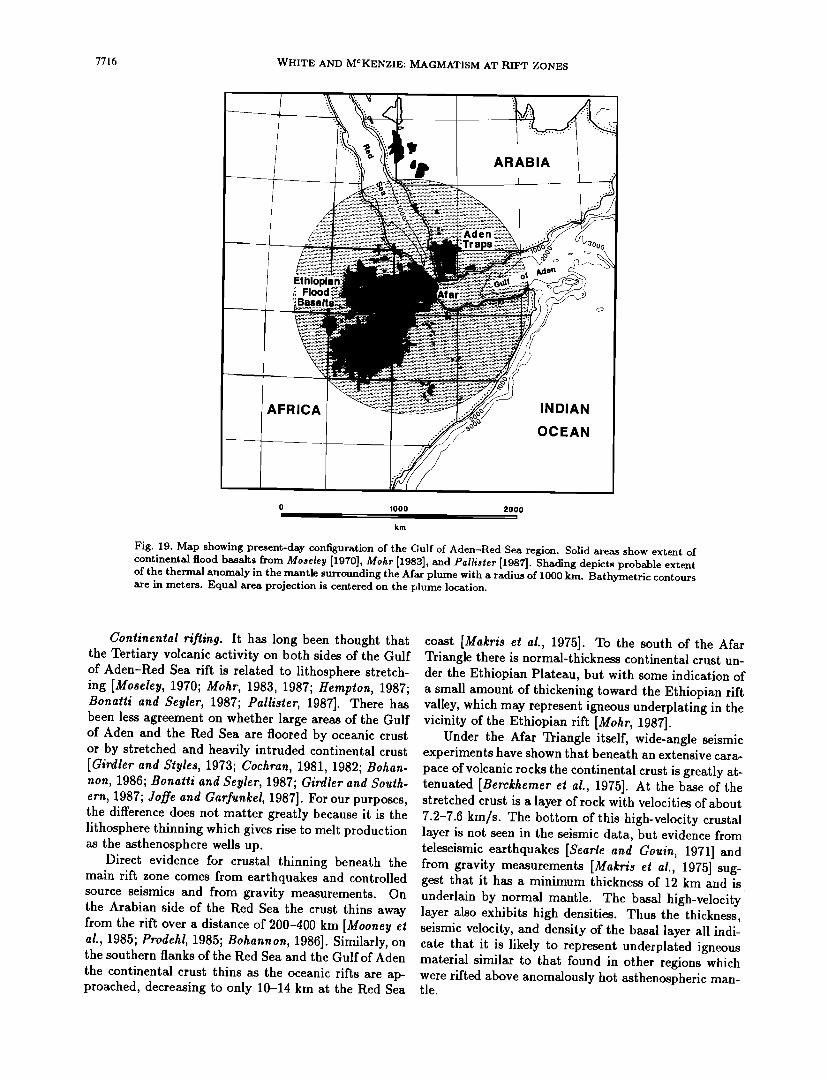
7716 WHITE AND MCKENZIE: MAGMATISM AT RIFT ZONES
ARABIA
AFRICA INDIAN
OCEAN
0 1000 2000
km
Fig. 19. Map showing present-day configuration of the Gulf of Aden-Red Sea region. Solid areas show extent of continental flood basalts from Moseley [1970], Mohr [1983], and Pallister [1987]. Shading depicts probable extent of the thermal anomaly in the mantle surrounding the Afar plume with a radius of 1000 km. Bathymetric contours are in meters. Equal area projection is centered on the plume location.
Continental rifling. It has long been thought that the Tertiary volcanic activity on both sides of the Gulf of Aden-Red Sea rift is related to lithosphere stretch- ing [Moseley, 1970; Mohr, 1983, 1987; Hemplon, 1987; Bonalli and $eyler, 1987; Pallislet, 1987]. There has been less agreement on whether large areas of the Gulf of Aden and the Red Sea are floored by oceanic crust or by stretched and heavily intruded continental crust [Girdler and Slyles, 1973; Cochran, 1981, 1982; Bobart- non, 1986; Bonalli and $eyler, 1987; Girdler and Soulh- em, 1987; Joffe and Gaffunkel, 1987]. For our purposes, the difference does not matter greatly because it is the lithosphere thinning which gives rise to melt production as the asthenosphere wells up.
Direct evidence for crustal thinning beneath the main rift zone comes from earthquakes and controlled source seismics and from gravity measurements. On the Arabian side of the Red Sea the crust thins away from the rift over a distance of 200-400 km [Mooney el al., 1985; Prodehl, 1985; Bohannon, 1986]. Similarly, on the southern flanks of the Red Sea and the Gulf of Aden the continental crust thins as the oceanic rifts are ap- proached, decreasing to only 10-14 km at the Red Sea
coast [Makris el al., 1975]. To the south of the Afar Triangle there is normal-thickness continental crust un- der the Ethiopian Plateau, but with some indication of a small amount of thickening toward the Ethiopian rift valley, which may represent igneous underplating in the vicinity of the Ethiopian rift [Mohr, 1987].
Under the Afar Triangle itself, wide-angle seismic experiments have shown that beneath an extensive cara- pace of volcanic rocks the continental crust is greatly at- tenuated [Berckhemer el al., 1975]. At the base of the stretched crust is a layer of rock with velocities of about 7.2-7.6 km/s. The bottom of this high-velocity crustal layer is not seen in the seismic data, but evidence from teleseismic earthquakes [Searle and Gouin, 1971] and from gravity measurements [Makris el al., 1975] sug- gest that it has a minimum thickness of 12 km and is underlain by normal mantle. The basal high-velocity' layer also exhibits high densities. Thus the thickness, seismic velocity, and density of the basal layer all indi- cate that it is likely to represent underplated igneous material similar to that found in other regions which were rifted above anomalously hot asthenospheric man- tle.
WHITE AND MCKENZIE: MAGMATISM AT RIFT ZONES 7717
The Afar plume. The initiation of volcanism over a broad region around the Afar Triangle at 30 Ma sug- gests that the Afar mantle plume first reached the base of the lithosphere at this time. Over perhaps 10 m.y. prior to this there is evidence of some rifting and block faulting in the Red Sea-Gulf of Aden area with only mi- nor associated volcanism [Hempton, 1987]. The lack of volcanism in the early rifting is evidence that the plume thermal anomaly only impinged on the lithosphere at approximately 30 Ma and only thereafter caused en- hanced volcanism in rifting regions. Dynamic uplift generated by the plume may well have assisted the lithosphere rifting which occurred subsequently. The thermal anomaly generated by a new plume is espe- cially large at the beginning, and this coupled with the relatively small amounts of lithosphere thinning, can explain the production of alkaline basalts and picritic basalts. Stretching continued until approximately 15 Ua.
From about 15 Ma until 4.5 Ma there was little con-
tinental rifting in the Red Sea and only scattered vol- canism. Stretching continued locally in the Wonji fault belt of the Ethiopian rift, causing local volcanism within the rifts. Vigorous extension recommenced in the Gulf of Aden and Red Sea at about 4.5 Ma. In the Gulf of
Aden it has now generated fully oceanic seafloor along a central oceanic spreading center. The renewed drifting at 4.5 Ma can be related to reconfiguration of plate mo- tions elsewhere [Cochran, 1981; Coleman, 1985; Hemp- ton, 1987].
The present position of the Afar mantle plume is in the center of the Afar Triangle (Figure 19) near the triple junction between the three rifts represented by the Gulf of Aden, the Red Sea, and the Ethiopian rift [Schilling, 1973]. It has generated considerable uplift across the region of the thermal anomaly. To the south, the Ethiopian Plateau is elevated more than 2000 In above sea level. Similar elevations have been generated to the north in the Yemen Plateau and along the flank of the Gulf of Aden. Part of this elevation may be attributed to crustal thickening by igneous underplat- ing or intrusion, but most of it must result from dy- namic uplift by the thermal anomaly surrounding the Afar plume.
A clear example of the uplift caused by the thermal anomaly is seen along the fully oceanic spreading center in the Gulf of Aden. Close to the center of the plume at the western end of the Gulf of Aden the spreading center is actually subaerial. Eastward the depth of the spread- ing center increases gradually away from the center of the plume. It only attains normal oceanic depths about 1000 km from the center of the Afar plume (Figure 14). This behavior is the same as that seen along the Reyk- janes Ridge spreading center as one moves away from the mantle plume under Iceland.
It is clear that the timing and extent of the volcan- ism, its chemical characteristics, the degree of crustal
thinning and of igneous underplating, and the uplift of this region are all consistent with rifting occurring above the broad thermal anomaly in the mantle caused by the Afar plume. We note that the Kenyan rift sys- tem is not connected with the Afar plume which we have discussed in this section. The Ethiopian rifts die out southward before the Kenyan rifts commence, and apparently there is no connection at depth between the Ethiopian and Kenyan rifts [Long, 1976]. The elevation and volcanism of the Kenyan rifts and the deep seismic structure are indicative of the influence of an underly- ing thermal anomaly in that region, too, but it must be caused by a different plume.
3.9. The West Australian Margin
Seaward dipping reflectors have been reported from seismic profiles across the northwest Australian conti- nental margin near the Scott Plateau [Hinz, 1981] and in the Cuvier Basin [Mutter et al., 1988]. They are less clear than, for example, in the North Atlantic but nev- ertheless are indicative that this was a volcanically ac- tive margin when it rifted. Unfortunately, unlike all the other volcanic rifted margins that we have considered, the conjugate margin to Australia is no longer available for study, as it has been destroyed in plate collision zones. So we are now unable to identify the nature of the conjugate margin or the track of the mantle plume reponsible for creating the thermal anomaly.
There was considerable magmatism along the west Australian margin at the time of breakup [Veevers and Cotterill, 1978]. Intense volcanism is exhibited on a se- ries of plateaus along the edge of the continental mar- gin, including the Scott Plateau, the northwest corner of the Exmouth Plateau, the Wallaby Plateau, and the Naturaliste Plateau (Figure 20). Seaward dipping re- flectors indicative of extrusive volcanism have been re-
ported from the flanks of the Scott Plateau and the Cuvier Basin. Although no seaward dipping reflectors have been reported from the oceanward flank of the Exmouth Plateau in the intervening region, there is ev- idence there from high seismic velocities in the lower crust for magmatic underplating beneath the stretched continental crust near the continent-ocean transition.
Breakup of the region and the onset of seafloor spreading started at about 150 Ma in the Argo Basin to the north of the region [Veevers and Heirtzler, 1974; Heirtzler et al., 1978], and somewhat later at about 125-120 Ma to the south in the Gascoyne, Cuvier, and Perth basins [Larson et al., 1979; Johnson et al., 1980; von Rad and E•con, 1982]. The volcanism along the margins was associated with this breakup and was caused, we suggest, by a broad thermal anomaly gen- erated by a mantle plume. Prior to the breakup there is a long history of rifting and subsidence in a series of basins along the margin, but with little concomitant volcanism. This provides supportive evidence that no hot plume was present in this area until shortly before
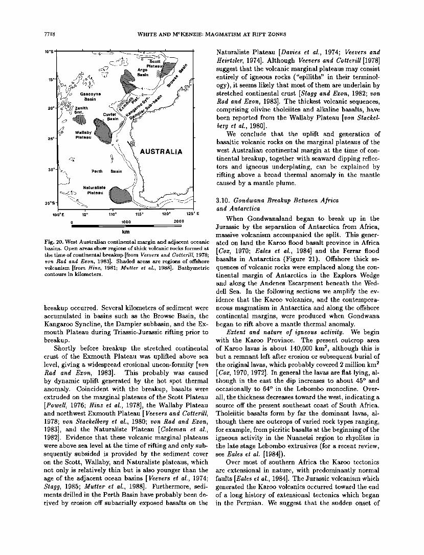
7718 WHITE AND MCKENZIE: MAGMATISM AT RIFT ZONES
10os I • _.}/• Gascoyne •• Basin 20 ø -r•o•/.• zenith
••v(j• Cuvier • Wallaby
25ø• - P•teau 30ø •• Perth Basin
• Naturaliste I• Plateau
100øE 10 ø 110 ø
Plab
Arg ø
sin
AUSTRALIA
115 ø 120 ø 125 ø E
0 1000 2000 !
km
Fig. 20. West Australian continental margin and adjacent oceanic basins. Open areas show regions of thick volcanic rocks formed at the time of continental breakup [from Veevers and Cotterill, 1978; yon Rad and Eaton, 1983]. Shaded areas are regions of offshore volcanism [from Hinz, 1981; Mutter et al., 1988]. Bathymetric contours in kilometers.
breakup occurred. Several kilometers of sediment were accumulated in basins such as the Browse Basin, the Kangaroo Syncline, the Dampier subbasin, and the Ex- mouth Plateau during Triassic-Jurassic rifting prior to breakup.
Shortly before breakup the stretched continental crust of the Exmouth Plateau was uplifted above sea level, giving a widespread erostonal uncon-formity [yon Rad and Exon, 1983]. This probably was caused by dynamic uplift generated by the hot spot thermal anomaly. Coincident with the breakup, basalts were extruded on the marginal plateaus of the Scott Plateau [Powell, 1976; Hinz et al., 1978], the Wallaby Plateau and northwest Exmouth Plateau [Veevers and Cotterill, 1978; yon Stackelberg et al., 1980; yon Rad and Exon, 1983], and the Naturaliste Plateau [Coleman et al., 1982]. Evidence that these volcanic marginal plateaus were above sea level at the time of rifting and only sub- sequently subsided is provided by the sediment cover on the Scott, Wallaby, and Naturaliste plateaus, which not only is relatively thin but is also younger than the age of the adjacent ocean basins [Veevers e! al., 1974; $tagg, 1985; Mutter et al., 1988]. Furthermore, sedi- ments drilled in the Perth Basin have probably been de- rived by erosion off subaerially exposed basalts on the
Naturaliste Plateau [Davies et al., 1974; Veevers and Heirtzler, 1974]. Although Veevers and Cotterill [1978] suggest that the volcanic marginal plateaus may consist entirely of igneous rocks ("epiliths" in their terminol- ogy), it seems likely that most of them are underlain by stretched continental crust [$tagg and Exon, 1982; yon Rad and Exon, 1983]. The thickest volcanic sequences, comprising olivine tholeiites and alkaline basalts, have been reported from the Wallaby Plateau [von Stackel- berg e! al., 1980].
We conclude that the uplift and generation of basaltic volcanic rocks on the marginal plateaus of the west Australian continental margin at the time of con- tinental breakup, together with seaward dipping reflec- tors and igneous underplating, can be explained by rifting above a broad thermal anomaly in the mantle caused by a mantle plume.
3.10. Gondwana Breakup Between Africa and Antarctica
When Gondwanaland began to break up in the Jurassic by the separation of Antarctica from Africa, massive volcanism accompanied the split. This gener- ated on land the Karoo flood basalt province in Africa [Cox, 1970; Eales et al., 1984] and the Ferrar flood basalts in Antarctica (Figure 21). Offshore thick se- quences of volcanic rocks were emplaced along the con- tinental margin of Antarctica in the Explora Wedge and along the Andenes Escarpment beneath the Wed- dell Sea. In the following sections we amplify the ev- idence that the Karoo volcanics, and the contempora- neous magmatism in Antarctica and along the offshore continental margins, were produced when Gondwana began to rift above a mantle thermal anomaly.
Extent and nature of igneous activity. We begin with the Karoo Province. The present outcrop area of Karoo lavas is about 140,000 km 2, although this is but a remnant left after erosion or subsequent burial of the original lavas, which probably covered 2 million km 2 [Cox, 1970, 1972]. In general the lavas are fiat lying, al- though in the east the dip increases to about 45 ø and occasionally to 64 ø in the Lebombo monocline. Over- all, the thickness decreases toward the west, indicating a source off the present southeast coast of South Africa. Tholeiitic basalts form by far the dominant lavas, al- though there are outcrops of varied rock types ranging, for example, from picritic basalts at the beginning of the igneous activity in the Nuanetsi region to rhyolites in the late stage Lebombo extrusives (for a recent review, see Eales e! al. [1984]).
Over most of southern Africa the Karoo tectonics
are extensional in nature, with predominantly normal faults [Eales et al., 1984]. The Jurassic volcanism which generated the Karoo volcanics occurred toward the end of a long history of extensional tectonics which began in the Permian. We suggest that the sudden onset of
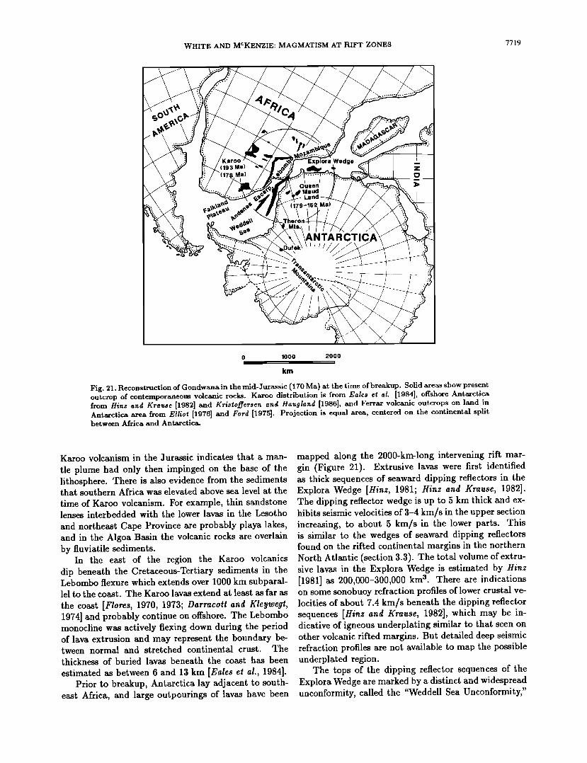
WHITE AND MCKENZIE: MAGMATISM AT RIFT ZONES 7719
( 19 3 Ma) Explora
Queen Maud Land
ANTARCTIC
0 1000 2000
km
Fig. 21. Reconstruction of Gondwana in the mid-Jurassic (170 Ma) at the time of breakup. Solid areas show present outcrop of contemporaneous volcanic rocks. Karoo distribution is from Eales et al. [1984], offshore Antarctica from Hinz and Krause [1982] and Kristoffersen and Haugland [1986], and Ferrar volcanic outcrops on land in Antarctica area from Elliot [1976] and Ford [1975]. Projection is equal area, centered on the continental split between Africa and Antarctica.
Karoo volcanism in the Jurassic indicates that a man- tle plume had only then impinged on the base of the lithosphere. There is also evidence from the sediments that southern Africa was elevated above sea level at the time of Karoo volcanism. For example, thin sandstone lenses interbedded with the lower lavas in the Lesotho and northeast Cape Province are probably playa lakes, and in the Algoa Basin the volcanic rocks are overlain by fiuviatile sediments.
In the east of the region the Karoo volcanics dip beneath the Cretaceous-Tertiary sediments in the Lebombo flexure which extends over 1000 km subparal- lel to the coast. The Karoo lavas extend at least as far as
the coast [Flores, 1970, 1973; Darracott and Kleywegt, 1974] and probably continue on offshore. The Lebombo monocline was actively flexing down during the period of lava extrusion and may represent the boundary be- tween normal and stretched continental crust. The thickness of buried lavas beneath the coast has been estimated as between 6 and 13 km [Eales et al., 1984].
Prior to breakup, Antarctica lay adjacent to south- east Africa, and large outpourings of lavas have been
mapped along the 2000-km-long intervening rift mar- gin (Figure 21). Extrusive lavas were first identified as thick sequences of seaward dipping reflectors in the Explora Wedge [Hinz, 1981; Hinz and Krause, 1982]. The dipping reflector wedge is up to 5 km thick and ex- hibits seismic velocities of 3-4 km/s in the upper section increasing, to about 5 km/s in the lower parts. This is similar to the wedges of seaward dipping reflectors found on the rifted continental margins in the northern North Atlantic (section 3.3). The total volume of extru- sive lavas in the Explora Wedge is estimated by Hinz [1981] as 200,000-300,000 km 3. There are indications on some sonobuoy refraction profiles of lower crustal ve- locities of about 7.4 km/s beneath the dipping reflector sequences [Hinz and Krause, 1982], which may be in- dicative of igneous underplating similar to that seen on other volcanic rifted margins. But detailed deep seismic refraction profiles are not available to map the possible underplated region.
The tops of the dipping reflector sequences of the Explora Wedge are marked by a distinct and widespread unconformity, called the "Weddell Sea Unconformity,"
7720 WHITE AND MCKENZIE: MAGMATISM AT RIFT ZONES
or "U9" by Hinz and Kristoffersen [1987]. It is pre- sumed to be of late Mid-Jurassic age and to be related to onset of separation of Africa and Antarctica.
Southwestward the thick extrusive lavas of the Ex-
plora Wedge continue into a 150-km-wide rift zone be- neath the southern Weddell Sea [Hinz and Krause, 1982]. Though volcanically active, this rift does not mark the site of the break between Africa and Antarc-
tica because that occurred slightly to the north along the 1000-km-long linear Andenes-Explora Escarpment, which was also volcanically active [Kristoffersen and Haugland, 1986] (Figure 21). The southern Weddell Sea rifted before the Andenes-Explora rift and was proba- bly caused by the same set of prebreakup rifting which generated a burst of volcanism in the Karoo prior to separation of Africa and Antarctica. The Andenes- Explora Escarpment marks the boundary between fully oceanic crust to the north and stretched, thinned con- tinental crust of Antarctica to the south [Kristoffersen and Haugland, 1986]. It exhibits its own set of sea- ward dipping reflectors caused by synrift volcanism, and truncates earlier rift structures.
Flood basalt volcanism also occurred on the Antarc-
tic land mass in the Jurassic at the time of the breakup of Gondwana, although the extensive ice cover leaves only patches of it exposed. Jurassic tholeiites are found in exposures throughout Queen Maud Land, and in- trusive dolerites occur in the Theron Mountains (Fig- ure 21). In the Vestfjella chain of nunataks near the Weddell Sea coast, between 1-2 km of mostly tholeiitic basalts were emplaced during the Jurassic in subaerial conditions [Krisioffersen and Haugland, 1986]. Sim- ilarly in northeastern Heimefrontjella, also in Queen Maud Land, at least 300 m of uniform basaltic lavas were extruded subaerially in the Mid-Jurassic [Juckes, 1972]. Elsewhere in Queen Maud Land, Jurassic vol- canics overlie the Beacon Group of sediments in the Kirwan Escarpment, and Jurassic dykes intrude them in the Theron Mountains and the Whichaway Nunataks [Brook, 1972; Hinz and Kristoffersen, 1987]. The com- positions and isotope ratios of the igneous rocks are sim- ilar to those of the Karoo tholeiites, which is consistent with their having a common origin [Ford and Kistler, 1980]. Furthermore, not only the extensive rift-related volcanism but also the elevation of the Antarctic region above sea level are consistent with the presence of a broad thermal anomaly in the mantle caused by a hot spot.
There is also extensive Jurassic volcanism through- out the Transantarctic Mountains (Figure 21) at ap- proximately the same time as the volcanism in Queen Maud Land adjacent to the continental rift between Africa and Antarctica. The Transantarctic volcanism is
generally assigned to the Ferrar Group [Grinalley, 1963]. However, despite being coeval, the Transantarctic ig- neous activity apparently has a different cause to the volcanism we have considered above, and it exhibits
marked differences in the major and minor elemental compositions, and in the strontium isotope and dis- persed element ratios [Brook, 1972; Faure et al., 1972, 1979; Juckes, 1972; Ford and Kistler, 1980]. The bound- ary between the two provinces lies between the massive Dufek intrusives, which are related to the Transantarc- tic Mountain type, and the Theron Mountains, which belong to the Weddell Sea and Queen Maud Land Province Figure 21). We only consider here the vol- canism from the latter province, which is related to the breakup between Africa and Antarctica.
In summary, there is extensive Jurassic volcanism related to the Africa-Antarctic rift, forming thick vol- canic sequences both offshore above the line of the conti- nental rupture and onshore on either side, in both Africa and Antarctica, where large volumes of flood basalts were eraplaced.
Continental Breakup. In a general sense it is clear that the extensive volcanism in Africa and Antarctica is
related to the breakup of Gondwanaland. However, de- tailed reconstructions show that the break did not occur
in a single, clean episode; there were many small con- tinental fragments involved, and there was probably at least one abortive period of rifting and possibly tran- scurrent faulting before a later break to fully oceanic crust occurred in the Mid-Jurassic.
Age determinations on Karoo igneous rocks have re- cently been reviewed by Fitch and Miller [1984], who conclude that there were two main periods of major basalt flood production, one at 193 q- 5 Ma and a sec- ond at 178 q- 5 Ma. There were other periods of minor, mostly intrusive volcanism and a much younger episode of flood basalt production in the Etendeka region at 120 q- 5 Ma. The 120 Ma phase was related to the split of the South Atlantic discussed in section 3.6 and is not
relevant to the Africa-Antarctic separation. The Karoo flood basalts were extruded very rapidly.
Fitch and Miller [1984] comment that the magmatism around 193 Ma "was undoubtedly one of the most sud- den, extensive and important events in the Mesozoic history of Africa." Of the extrusive episode around 178 Ma, they say that it "occurred over a very short time interval" and that in both the 193 and 178 Ma
cases, the "regional eruption rates must have been lit- erally enormous." It is not certain which of the events was dominant; Cox [1988] comments that some of the formations, for example in the Lebombo, that appear to be diachronous from radiometric age determinations appear from field relationships to belong to a single ex- trusive episode.
The Jurassic lavas in the Weddell Sea-Queen Maud Land area of Antarctica all appear to belong to a single igneous phase. None of them is older than about 179 Ma [Ford and Kistler, 1980], which correlates well with the second phase of extrusives in the Karoo discussed above. The tholeiitic basalts in Queen Maud Land are dated as 179-162 q- 6 Ma by Rex [1972], and a whole rock K-
WHITE AND MCKENZIE: MAGMATISM AT RIFT ZONES 7721
Ar age on basalt from Bj0rnnutane in the same region yields 174 4- 7 Ma [Juckes, 1972]. Dolerites intruded into the Theron Mountains yield ages of about 169-154 4. 6 Ma [Rex, 1972], although only a few samples have been dated.
The offshore lavas are not well dated, other than by the widespread overlying Weddell Sea unconformity, which is assumed to have a late Middle Jurassic age (about 170 Ma) by Hinz and Kristoffersen [1987].
The oldest identifiable seafloor spreading anomalies suggest that breakup of Gondwanaland occurred at the earliest at about 170 Ma [Martin and Hartnady, 1986]. Since there was probably a period of rifting prior to the onset of fully developed seafloor spreading, the 178 4. 5 Ma dates of flood basalt volcanism in the Karoo and 179-162 Ma in Antarctica correlate well with the Gond-
wana breakup. The earlier phase of volcanism around 193 Ma in the Karoo, and the formation of the vol- canically active failed rift in the Weddell Sea probably reflect an earlier phase of rifting that did not develop fully into seafloor spreading. As commented earlier, the long phase of extensional rifting in southern Africa that was not accompanied by significant volcanism until the outburst at 193 Ma is indicative that it was only at that time that a mantle plume started to generate anoma- lously hot asthenospheric mantle beneath this region.
We suggest that the most likely location of the thermal plume was beneath the coastal region of the Lebombo monocline. A 1000-km-radius circle, which is the typical extent of the thermal anomaly created by a plume, neatly encompasses the 1700-km-long off- shore volcanically active portion of the continental rift and the volcanics of the Karoo and Antarctica (Figure 21). Supportive evidence for the presence of the plume beneath this area comes from the very thick igneous sequence, which may reach 13-km thickness beneath the coastal region and is either very heavily intruded, stretched continental crust or, like Iceland, consists en- tirely of new igneous material. Considerable uplift of this central region, as would be expected above a man- tle plume, is indicated by the occurrence of continen- tal conglomerates above the volcanic rocks [Martin and Hartnady, 1986]. Marine sediments were not deposited here until the Barremian [Forster, 1975], several tens of millions of years after breakup.
The presence of a thermal plume in this region is also indicated by the subsequent generation of the Madagas- car Ridge as the plume moved northeastward away from Africa. The Madagascar Ridge comprises a 25-km-thick igneous pile formed above a hot spot [Sinha et al., 1981]. The neighboring Mozambique Ridge may similarly be an igneous ridge, particularly as tholeiitic basalts have been drilled from it, although the slop in reconstruc- tion would also allow it to be a dislocated continental
fragment [Martin and Hartnady, 1986]. If a fixed hot spot reference frame is used, Morgan [1981] shows that the hot spot at present beneath Crozet would have lain
near the northern edge of the Karoo volcanic outcrops at the time of Gondwana breakup. However, given that relative motions of 10-30 mm/yr can occur between hot spots, it is likely that the Crozet hot spot could have lain slightly further south in our favored position be- neath the Lebombo monocline at the time Antarctica
broke away from Africa.
4. DISCUSSION
In the first part of this paper we have shown that thermal plumes in the mantle feed mushrooms of ab- normally hot mantle immediately beneath the litho- sphere. Their diameter is typically 1500-2000 km, and the temperature is of the order of 100-150øC above normal. When the lithosphere is thinned by rifting, decompression of the upwelling asthenospheric mantle produces melt which rapidly moves upward to the over- lying crust. The relatively small increase of tempera- ture around mantle plumes dramatically enhances the amount of melt produced by passive upwelling. We ex- plore in detail the predictions of our hot spot rifting model concerning the volume of igneous rocks produced, their geochemical, seismic, and density signatures, the effect on subsidence of rifted margins, and the timing of igneous activity. In the second half of the paper we show how our model can explain all the major volcanic con- tinental margins and associated flood basalts. An iden- tical model can be applied to other considerably older flood basalt provinces such as the 1100 Ma Keweenawan volcanics of the Mid-Continent Rift System, where we deduce an initial potential temperature of 1510-1560øC, some 150-200øC above the ambient mantle temperature at the time of rifting.
The production of voluminous igneous rocks on some rifted continental margins provides a major mech- anism for increasing the volume of the continental crust. With the present number and global distribution of hot spots, we expect that at least one hot spot will pass un- der any point on the Earth every few hundred million years. The hot spot will not always cause continen- tal breakup, nor does continental rifting always occur above hot spots. However, the presence of a hot spot itself causes considerable dynamic uplift and additional tensional forces in the lithosphere. So if the stress field in any given region is such that incipient rifting is likely to occur, then the initiation of a new plume beneath that area, or the passage of the area above an exist- ing plume may well lead to lithosphere rifting. Fur- thermore, if rifting does occur shortly after initiation of a new mantle plume, then the increased temperature anomaly in the blob with which the plume commences will lead to the initial generation of particularly large quantities of melt as the mantle decompresses.
The interplay of continental breakup and hot spot locations over the past 200 m.y. is such that on aver- age a major igneous province is generated once every
7722 WHITE AND MCKENZIE: MAGMATISM AT RIFT ZONES
30 m.y. Those we have discussed in this paper (Fig- ure 1) include the Ethiopian and Yemen regions around Afar at about 30 Ma, the North Atlantic Tertiary ig- neous province, and the Seychelles-Deccan both at ap- proximately 60 Ma, the South Atlantic, Parana, and Etendeka provinces together with the west Australian margin at about 120 Ma, and the Karoo-Antarctic and central Atlantic splits during 190-170 Ma. If each split produced about 10 million km 3 of new igneous crust, as deduced from the North Atlantic Tertiary Province, then we might expect to add about 330 million km 3 of mantle-derived igneous rocks to the continental crust every 1000 m.y.; an average of around 0.3 kmS/yr.
To this minimum estimate we should add the con-
tribution from other volcanically active areas of rift- ing above hot spots which have not progressed fully to an oceanic split. Presently active examples include the Basin and Range Province, where some 3 million km s of igneous material has been added to the crust, the Columbia River flood basalts, and the Kenya rift. We should also take account of the small volume of igneous rock added to the crust along continental margins which have rifted above normal-temperature asthenospheric mantle. Although only 1-2 km of igneous rock may be generated (Figure 3), this nevertheless adds up to a significant volume along the total length of the world's nonvolcanic rifted margins.
We estimate the total rate of growth of the conti- nental crust by melt production above rifted regions as 0.4 kmS/yr. Since much of this material is added or intruded into the base of the crust, we will not see all of it in the surface geology. By comparison, if the conti- nental crust had grown at a constant rate to its present volume of 7.6 x 10⁹ km s [Rayrner and Schubert, 1984] over the 4500-m.y. history of the Earth, the average growth rate would be 1.7 km3/yr. Most authors, how- ever, consider that growth rates were much greater in the early Archaean, and that during the Phanerozoic they have been somewhere between zero and I kmS/yr (for a review of growth rate estimates, see Rayrner and Schubert [1984]).
Our estimation of continental growth rates by ig- neous addition in rifted regions could thus account for the majority of the increase of continental volume dur- ing the Phanerozoic. We note also that our calcula- tion assumes that rates of plate motion and astheno- spheric mantle temperatures have remained the same as at present throughout geologic time. If either were higher during the early history of the Earth, as seems likely, then considerably more melt would have been produced by our mechanism of decompression melting beneath rifted regions.
Another by-product of our model is that it may provide a mechanism for explaining some of the widespread and catastrophic extinctions that have oc- curred through geologic time. The major extinction at the Cretaceous-Tertiary boundary is perhaps the best
known example. Two major mechanisms for extinctions have been proposed, one relying on collision with large extraterrestrial objects, the other suggesting that vol- canism is the cause [e.g., Alvares et al., 1980; Officer and Drake, 1983, 1985; Courtillot and Cisowski, 1987; Hallam, 1987; Hut et al., 1987; Officer et al., 1987].
Both mechanisms rely on large quantities of dust be- ing thrown up into the upper atmosphere and thereby blocking out sunlight with a concomitant sudden change in the temperature of the Earth's surface leading to the death of many organisms. Other factors such as the injection of sulfate aerosols into the atmosphere may also cause potentially damaging environmental conse- quences [Stothers et al., 1986]. Without wishing to enter into the protracted arguments for and against the two hypotheses, it is clear that our model provides a method for generating rapid and intense volcanism as a normal consequence of rifting above hot mantle. At least some of the volcanism is explosive, generating massive ash- falls. In the North Atlantic Tertiary igneous province, for example, over 100 separate ashfalls have been iden- tified in the North Sea sediments [Knox and Morton, 1988]. The interval between major igneous episodes re- sulting from rifting above hot spots is typically of the order of 30 m.y., which falls into the typical timespan between observed major extinctions.
In conclusion, this survey shows that our simple no- tions of rifting above hot spots can explain all the main features of the world's major igneous provinces. It pro- vides a powerful predictive tool for assessing the geolog- ical and subsidence history of rifted regions. There are many detailed studies which can be made to test our model. One field of investigation upon which we have touched only briefly in this paper is the geochemical na- ture and isotopic signature of the igneous rocks, which provide a sensitive indicator of the mantle temperature and conditions under which they were generated. An- other valuable test is to look for geophysical evidence of igneous underplating, or intrusion in the lower crust under rifted regions. Last, classical geological investi- gations of the subsidence history of rifted regions and the precise relationships between tectonic events, mag- matism and the onset of seafloor spreading along rifted continental margins can provide important tests of our model.
Acknowledgments. The bulk of this paper was written while R.S.W. was a Cecil and Ida H. Green Scholar at IGPP, Scripps Institution of Oceanography. He gratefully acknowledges support from the Green Foundation and the provision of facilities, includ- ing an excellent library, and outstandingly beautiful surroundings at Scripps. The following people kindly provided preprints of their work prior to publication, for which we are grateful: Enrico Bonatti, Keith Cox, Roy Hyndman, Charlotte Keen, Kim Klit- gord, Robert Knox, Andy Morton, Alan Mussett, John Mutter, R. H. Noble, Frank Richter, Don Tarling, and Bob Whitmarsh. We thank Phyl Fisher for help with the illustrations and Elaine Blackmore and Barbara Dyson for typing the manuscript. The equal-area reconstructions of the continents were made using a
WHITE AND MCKENZIE: MAGMATISM AT RIFT ZONES 7723
computer program called Atlas developed by Alan Smith at Cam- bridge. Department of Earth Sciences, Cambridge, contribution ES1276.
REFERENCES
Ahern, J. L., and D. L. Turcotte, Magma migration beneath an ocean ridge, Earth Planet. Sci. Lett., .15, 115-122, 1979.
Alvarez, L. W. W. Alvarez, F. Asaro, and H. V. Michel, Extrater- restrial cause for the Cretaceous-Tertiary extinction, Science, 208, 1095-1108, 1980.
Amaral, G., U. G. Cordant, K. Kawashita, and J. H. Reynolds, Potassium-argon dates of basaltic rocks from southern Brazil, Geochim. Cosmochim. Acta, 30, 159-189, 1966.
Anderson, R. N., D. P. MCKenzie, and J. G. Sclater, Gravity, bathymetry, and convection in the Earth, Earth Planet. Sci. Leit., 18, 391-407, 1973.
Austin, J. A., Jr., The geology of the passive margin off New England, Ref. 79-27, 201 pp., Woods Hole Oceanogr. Inst., Woods Hole, Mass., 1978.
Austin, J. A., and E. Uchupi, Continental-oceanic crustal transi- tion off southwest Africa, Am. Assoc. Petrol. Geol. Bull., 66, 1328-1347, 1982.
Baker, B. H., P. Mohr, and L. A. J. Williams, Geology of the eastern rift system of Africa, Spec. Pap. Geol. Soc. Am., 136, 1-67, 1972.
Bally, A. W., Atlantic-type margins, in Geology of Passive Con- tinental Margins, Education Course Notes Set. 19, edited by A. W. Bally, pp. I1-I48, American Association of Petroleum Geologists, Tulsa, Okla., 1981.
Barton, P., and R. Wood, Tectonic evolution of the North Sea Basin: Crustal stretching and subsidence, Geophys. J. R. As- tron. Soc., 79, 987-1022, 1984.
Beane, J. E., C. A. Turner, P. R. Hooper, K. V. Subbarao, and J. N. Walsh, Stratigraphy, composition and form of the Dec- can basalts, Western Ghats, India, Bull. Volcanol., .18, 61-83, 1986.
Beaumont, C., C. E. Keen, and R. Boutliter, On the evolution of rifted continental margins: Comparison of models and obser- vations for the Nova Scottan region, Geophys. J. R. Astron. Soc., 70, 667-716, 1982.
Behrendt, J. C., D. J. Drewry, E. Jankowsky, and M. S. Grim, Aeromagnetic and radio echo ice-sounding measurements show much greater area of the Dufek intrusion, Antarctica, Science, 209, 1014-1017, 1980.
Behrendt, J. C., R. M. Hamilton, H. D. Ackerman, V. J. Henry, and K. C. Bayer, Marine multichannel seismic-reflection ev- idence for Cenozoic faulting and deep crustal structure near Charleston, South Carolina, Studies related to the Charleston, South Carolina earthquake of 1886--tectonics and seismicity, U.S. Geol. Surv. Prof. Pap., 1313, J1-J29, 1983.
Belltent, G., P. Brotzu, P. Comin-Chiaramonti, M. Ernesto, A. J. Melfi, I. G. Pacca, E. M. Piccirillo, and D. Stolfa, Petrolog- ical and paleomagnetic data on the plateau basalt to rhyolite sequences of the southern Paran& Basin (Brazil), Am. Acad. Bras. Cienc., 55, 355-383, 1983.
Belltent, G., P. Brotzu, P. Comin-Chiaramonti, M. Ernesto, A. J. Melfi, I. G. Pacca, and E. M. Piccirillo, Flood basalt to rhyo- lite suites in the southern Paran& Plateau (Brazil): Paleomag- netism, petrogenesis and geodynamic implications, J. Petrol., 25, 579-618, 1984.
Berckhemer, H., B. Baier, H. Bartelson, A. Behle, H. Burkhardt, H. Gebrande, J. Makris, H. Menzel, H. Miller, and R. Vees, Deep soundings in the Afar region and on the highland of Ethiopia, in Afar Depression of Ethiopia, edited by A. Pilger and A. Rosier, pp. 89-113, E. Schweizerbart, Stuttgart, West Germany, 1975.
Berggren, W. A., D. V. Kent, and J. Flynn, Jurassic to Pale- ogene, 2, Paleogene geochronology and chronostratigraphy, in Geochronology and the Geological Record, Mera. 10, edited by
N. Snelling, pp. 141-186, Geological Society of London, Eng- land, 1985.
Bickle, M. J. Implications of melting for stabilisation of the litho- sphere and heat loss in the Archaean, Earth Planet. Sci. Lett., 80, 314-324, 1986.
Bohannon, R. G., How much divergence has occurred between Africa and Arabia as a result of the opening of the Red Sea?, Geology, 1.1, 510-513, 1986.
Boillot, G. M., M. Recq, E. L. Winterer, W. Meyer, J. Ap- plegate, M. Galtuck, J. A. Bergen, and others, Tectonic de- nuclation of the upper mantle along passive margins: a model based on drilling results (ODP Leg 103, western Galicia, Spain), Tectonophysics, 132, 335-342, 1987.
Bonatti, E., and M. Seyler, Crustal underplating and evolution in the Red Sea rift: Uplifted gabbro/gneiss crustal complexes on Zabargad and Brothers islands, J. Geophys. Res., 92, 12,803- 12,821, 1987.
Bosworth, W., Geometry of propagating continental rifts, Nature, 316, 625-627, 1985.
Bosworth, W., Off-axis volcanism in the Gregory rift, east Africa: Implications for models of continental rifting, Geology, 15, 397- 400, 1987.
Bott, M. H. P., and K. Gunnarsson, Crustal structure of the Iceland-Faeroe Ridge, J. Geophys., ,t7, 221-227, 1980.
Boyd, F. R., J. J. Gurney, and S. H. Richardson, Evidence for a 150-200 km thick Archean lithosphere from diamond inclusion thermobarometry, Nature, 315, 387-389, 1985.
Brook, D., Stratigraphy of the Theron Mountains, Br. A ntarct. Surv. Bull., 29, 67-89, 1972.
Bunch, A. W. H., and B. L. N. Kennett, The crustal structure of the Reykjanes Ridge at 59ø30tN, Geophys. J. R. Astron. Soc., 61,141-166, 1980.
Chave, A.D., Lithospheric structure of the Walvis Ridge from Rayleigh wave dispersion, J. Geophys. Res., 8.1, 6840-6848, 1979.
Civetta, L., L. La Volpe, and L. Lirer, K-Ar ages of the Yemen Plateau, J. Volcanol. Geotherra. Res., .1, 307-314, 1978.
Clarke, D. B., Tertiary basalts of B& Bay: Possible primary magma from the mantle, Contrib. Mineral. Petrol., 25, 203, 1970.
Clarke, D. B., and A. K. Pederson, Tertiary volcanic province of west Greenland, in Geology of Greenland, edited by A. Es- cher and W. S. Watt, pp. 365-385, The Geological Survey of Greenland, Copenhagen, 1976.
Clarke, D. B., and B. G. J. Upton, Tertiary basalts of BafFtn Island: Field relations and tectonic setting, Can. J. Earth Sci., 8, 248-258, 1971.
Cochran, J. R., The Gulf of Aden: Structure and evolution of a young ocean basin and continental margin, J. Geophys. Res.; 86, 263-287, 1981.
Cochran, J. R., The magnetic quiet zone in the eastern Gulf of Aden: Implications for the early development of the continental margin, Geophys. J. R. Astron. Soc., 68, 171-201, 1982.
Coleman, P. J., P. J. Michael, and J. C. Mutter, The origin of the Naturaliste Plateau, S.E. Indian Ocean: Implications from dredged basalts, J. Geol. Soc Aust., 29, 457-468, 1982.
Coleman, R. G., Geologic background of the Red Sea, Init. Rep. Deep Sea Drill. Proj., 23, 813-819, 1974.
Coleman, R. G., The Red Sea: A small ocean basin formed by continental extension and sea floor spreading, Int. Geol. Congr. 27th, U23, 93-121, 1985.
Cordant, U. G., P. L. P. Sartori, and K. Kawashita, Geoquimica dos isotopos de estroncio e a evolucao da ativiclade vulcanica na Bacia do Paran& (sul do Brazil) durante o Cretocea, An. A cad. Bras. Cienc., 52, 811-818, 1980.
Courtillot, V. E., and C. Cisowski, The Cretaceous-Tertiary boundary events: External or internal causes?, Eos Trans. A G U, 68, 193-200, 1987.
Courtillot, V., J. Besse, D. Vandamme, R. Montigny, J. J. Jaeger, and H. Cappetta, Deccan flood basalts at the Creta- ceous/Tertiary boundary?, Earth Planet. Sci. Lett., 80, 361- 374, 1986.
7724 WHITE AND MCKENZIE: MAGMATISM AT RIFT ZONES
Courtillot, V., G. F4raud, H. Maluski, D. Vandamme, M. G. Moreau, and J. Besse, Deccan flood basalts and the Creta- ceous/Tertiary boundary, Nature, 333, 843-846, 1988.
Courtney, R. C., and M. Recq, Anomalous heat flow near the Crozet Plateau and mantle convection, Earth Planet. Sci. Lett., 79, 373-384, 1986.
Courtney, R. C., and R. S. White, Anomalous heat flow and geoid across the Cape Verde Rise: evidence for dynamic support from a thermal plume in the mantle, Geophys. J. R. Astron. Soc., 87, 815-867, and microfiche GJ 87/1 1986.
Cox, K. G., Tectonics and vulcanism of the Karroo period and their bearing on the postulated fragmentation of Gondwana- land, in African Magmatism and Tectonics, edited by T. N. Clifford and I. G. Gass, pp. 211-235, Oliver and Boyd, Edin- burgh, 1970.
Cox, K. G., The Karroo volcanic cycle, J. Geol. Soc. London 128, 311-336, 1972.
Cox, K. G., The Karoo Province, in Flood Basalts, edited by J. D. Macdougall, Kluwer Academic Publishers, Hingharn, Mass., 1988.
Craig, C. H., and D. P. MCKenzie, Surface deformation, grav- ity and the geoid from three dimensional convection at low Rayleigh numbers, Earth Planet. Sci. Lett., 83, 123-136, 1987.
Crough, S. T., Thermal origin of mid-plate hot-spot swells, Geo- phys. J. R. Astron. Soc., 55, 451-469, 1978.
Crough, S. T., Mesozoic hotspot epeirogeny in eastern North America, Geology, 9, 2-6, 1981.
Crough, S. T., and R. D. Jarrard, The Marquesas-Line swell, J. Geophys. Res., 86, 11,763-11,771, 1981.
Curry, D., and G. S. Odin, Dating of the Palaeogene, in Numerical Dating in Statigraphy, edited by G. S. Odin, pp. 607-629, John Wiley, New York, 1982.
Darracott, B. W., and R. J. Kleywegt, The structure of the south- ern portion of the Lebombo volcanic belt deduced from gravity data, Trans. Geol. Soc. S. A.•r., 77, 301-308, 1974.
Davies, T. A., B. P. Luyendyk, et al., (Eds.), Initial Rep. Deep Sea Drill. Proj. 26, 1129 pp., 1974.
de Boer, J. Z., J. G. MCHone, J. H. Puffer, P. C. Ragland, and D. Whittington, Mesozoic and Cenozoic magrnatism, in The Geology o.• North America, Vol. I-2, The Atlantic Continental Margin, U.S., edited by R. E. Sheridan and J. A. Grow, pp. 217-241, Geological Society of America, Boulder, Colo., 1988.
Denham, L. R., Offshore geology of northern West Greenland (69 ø to 75øN), Rep. Geol. Surv. Greenland 63, 24 pp., 1974.
Deshmukh, S.S., Volcanological and petrological appraisal on Deccan basalts, Sci. Lecture Set. 1, pp. 30-56, Gondwana Geological Society, India, 1982.
Detrick, R. S., and A. B. Watts, An analysis of isostasy in the world's oceans: Three aseismic ridges, J. Geophys. Res., 84, 3637-3655, 1979.
Detrick, R. S., R. P. yon Herzen, B. Parsons, D. Sandwell, and M. Doughe, Heat flow on the Bermuda Rise and thermal models of mid-plate swells, J. Geophys. Res., 91, 3701-3723, 1986.
de Voogd, B., and C. E. Keen, Lithoprobe east: Results from re- flection profiling of the continental margin: Grand Banks Re- gion, Geophys. J. R. Astron. Soc., 89, 195-200, 1987.
Duncan, R. A., Hot spots in the southern oceans--an absolute frame of reference for motion of the Gondwana continents, Tectonophysics, 74, 29-42, 1981.
Duncan, R. A., Age progressive volcanism in the New England seamounts and the opening of the central Atlantic Ocean, J. Geophys. Res., 89, 9980-9990, 1984.
Duncan, R. A., and D. G. Pyle, Rapid eruption of the Dec- can flood basalts at the Cretaceous/Tertiary boundary, Nature, 333, 841-843, 1988.
Eales, H. V., J. S. Marsh, and K. G. Cox, The Karoo igneous province: An introduction, Petrogenesis of the volcanic rocks of the Karoo Province, Spec. Publ. Geol. Soc. S. A.•r., 13, 1-26, 1984.
Eldholm, O., J. Thiede, and ODP Leg 104 Scientific Party, For- mation of the Norwegian Sea, Nature, 319, 360-361, 1986.
Elliot, D. H., The tectonic setting of the Jurassic Ferrar Group, Antartica, in Proceedings o! the Symposium on Andean and Antarctic Volcanology Problems, Santiago, edited by D. G. Fer- ran, pp. 357-372, International Association of Volcanology and Chemistry of the Earth's Interior, Naples,1976.
Erlank, A. J., J. S. Marsh, A. R. Duncan, R. McG. Miller, C. J. Hawkesworth, P. J. Betton, and D.C. Rex, Geochem- istry and petrogenesis of the Etendelta volcanic rocks from SWA/Namibia, Petrogenesis of the volcanic rocks of the Ka- roo Province, Spec. Publ. geoL Soc. S. A.•r., 13, pp. 195-245, 1984.
Faure, G., R. L. Hill, L. M. Jones, and D. H. Elliot, Isotope com- position of strontium and silica content of Mesozoic basalt and dolerite from Antarctica, in Antarctic Geology and Geophysics, edited by R. J. Adie, pp. 617-624, Universitetsforlaget, Oslo, 1972.
Faure, G., J. R. Bowman, and D. H. Elliott, The initial 87Sr/S6Sr ratios of the Kirwan volcanics of Dronning Maud Land: Com- parison with the Kirkpatrick Basalt, Transantarctic Mountains, Chem. Geok, 26, 77-90, 1979.
Fisher, R. L., and E. T. Bunce et al., (Eds.), Initial Rep. Deep Sea Drill. Proj., 24, 1183 pp., 1974.
Fitch, F. J., and J. A. Miller, Dating Karoo igneous rocks by the conventional K-Ar and 40 Ar/39 Ar age spectrum methods, Petrogenesis of the volcanic rocks of the Karoo Province, Spec. Publ. Geol. Soc. S. A.fr., 13, 1-26, 1984.
Flores, G., Suggested origin of the Mozambique channel, Trans. Geol. Soc. S. A.fr., 73, 1-7, 1970.
Flores, G., The Cretaceous and Tertiary sedimentary basins of Mozambique and Zululand, in Sedimentary Basins o! the A.frican Coasts, Part 2, edited by G. Blant, pp. 81-111, Asso- ciation for African Geological Surveys, Paris, 1973.
Foland, K. A., and M. Faul, Ages of the White Mountain intrusives--New Hampshire, Vermont and Maine, U.S.A., A m. J. Sci., 277, 888-904, 1977.
Ford, A. B., and R. W. Kistler, K-Ar age, composition, and origin of Mesozoic mafic rocks related to Ferrar Group, Pensacola Mountains, Antarctica, N. Z. J. Geol. Geophys., 23, 371-390, 1980.
Forster, R., Geological history of the sedimentary basin of south- ern Mozambique and some aspects of the origin of the Mozam- bique Channel, Palaeogeogr. Palaeoclimatol. Palaeoecol,, 17, 267-287, 1975.
Foucher, J.-P., X. Le Pichon, and J.-C. Sibuet, The ocean- continent transition in the uniform lithospheric stretching model: Role of partial melting in the mantle, Philoz. Trans. R. Soc. London, Set. A, 305, 27-43, 1982.
Fowler, S. R., and D. P. MCKenzie, Gravity studies of the Ex- mouth and Rockall Plateaux using Seasat altimetry, Basin Res., in press, 1989.
Furlong, K. P., and D. M. Fountain, Continental crustal under- plating: Thermal considerations and seismic-petrologic conse- quences, J. Geophys. Res., 91, 8285-8294, 1986.
Gerrard, I., and G. C. Smith, Post-Palaeozoic succession and structure of the southwestern African continental margin, Stud- ies in continental margin geology, Mem. Am. Assoc. Pet. Geol., 34 49-76, 1982.
Geukens, F., Geology of the Arabian Peninsular, Yemen, U.S. Geol. Surv. Prof. Pap., 560-B, 1966.
Gibson, D., A. G. MCCormick, I. G. Meighan, and A. N. Halliday, The British Tertiary Igneous Province: Young Rb-Sr ages for the Mourne Mountains Granite, Scot. J. Geol., 23, 221-225, 1987.
Ginzburg, A., R. B. Whitmarsh, D. G. Roberts, L. Montadert, A. Camus, and F. Avedik, The deep seismic structure of the north- ern continental margin of the Bay of Biscay, Ann. Geophys., 3, 499-510, 1985.
Girdler, R. W., and T. C. Southern, Structure and evolution of the northern Red Sea, Nature, 330, 716-721, 1987.
Girdler, R. W., and P. Styles, Two stage Red Sea floor spreading, Nature, 247, 1-11, 1973.
WHITE AND MCKENZIE: MAGMATISM AT RIFT ZONES 7725
Goslin, J., and J.-C. Sibuet, Geophysical study of the easternmost Walvis Ridge, South Atlantic: Deep structure, Geol. Soc. Am. Bull., 86, 1713-1724, 1975.
Greenwood, J. E.G. W., and D. Bleackley, Geology of the Ara- bian Peninsula Aden Protectorate, U.S. Geol. Surv. Prof. Pap., 560-C, 1967.
Grindley, G. W., The geology of the Queen Alexandra Range, Beardmore Glacier, Ross Dependency, Antarctica, with notes on the correlation of Gondwana sequences, N. Z. J. Geol. Geo- phys., 6, 307-347, 1963.
Haigh, B. I. R., North Atlantic oceanic topography and lateral variations in the upper mantle, Geophys. J. R. Astron. Soc., 33, 405-420, 1973.
Hallam, A., End-Cretaceous mass extinction event: Argument for terrestrial causation, Science, 238, 1237-1242, 1987.
Hamilton, R. M., J. C. Behrendt, and H. D. Ackerman, Land multichannel seismic-reflection evidence for tectonic features
near Charleston, S.C., Studies related to the Charleston, South Carolina earthquake of 1886--Tectonics and seismicity, U.S. Geol. Surv. Prof. Pap., 1313, I1-I18,1983.
Harland, W. B., A. V. Cox, P. G. LleweRyn, C. A. G. Pickton, A. G. Smith, and R. Walters, A Geologic Time Scale, 131 pp., Cambridge University Press, New York, 1982.
Hawkesworth, C. J., M. S. M. Mantovani, P. N. Taylor, and Z. Palacz, Evidence from the Paran& of south Brazil for a con- tinental contribution to Dupal basalts, Nature, 322, 356-359, 1986.
Heirtzler, J. R., P. J. Cameron, P. J. Cook, T. PoweR, H. A. Roeser, S. Sukaxdi, and J. J. Veevers, The Argo abyssal plain, Earth Planet. Sci. Left., 48, 21-31, 1978.
Hekinian, R., Volcanics from the Walvis Ridge, Nature Phys. Sci., 239, 91-93, 1972.
Hempton, M. R., Constraints on Arabian plate motion and ex- tensional history of the Red Sea, Tectonics, 6, 687-705, 1987.
Herzberg, C. J., W. S. Fyfe, and M. J. Cart, Density constraints on the formation of the continental Moho and crust, Contrib. Mineral. Petrol., 84, 1-5, 1983.
Hill, M. N., Recent geophysical exploration of the ocean floor, Phys. Chem. Earth, 2, 129-163, 1957.
Hinz, K., A hypothesis on terrestrial catastrophes: Wedges of very thick oceanward dipping layers beneath passive continen- tal margins, Geol. J., E22, 3-28, 1981.
Hinz, K., and H. Closs, Ergebnisse seismicher Untersuchungen im nordlichen Arabischen Meer, ein Beitrag zur Internationalen In- dischen Ozean Expedition, III, Auswertung und Ergebnisse der seismichen Messungen und ihre geologische Deutung, "Meteor" Forschungsergeb. Reihe C, 2, 9-28, 1969.
Hinz, K., and W. Krause, The continental margin of Queen Maud Land, Antarctica: Seismic sequences, structural elements and geological development, Geol. Jahrb., E23, 17-41, 1982.
Hinz, K., and Y. Kristoffersen, Antarctica: Recent advances in the understanding of the continental shelf, Geol. Jahrb., E37, 3-54, 1987.
Hinz, K., H. Beirsdorf, N. F. Exon, H. A. Roeser, H. M. J. Stagg, and U. yon Stackelberg, Geoscientific investigations from the Scott Plateau off northwest Australia to the Java Trench, BMR J. Aust. Geol. Geophys., 3, 319-340, 1978.
Hinz, K., H. Dostmann, and J. Fritsch, The continental margin of Morocco: Seismic sequences, structural elements and geological development, in Geology of the Northwest African Continental Margin, edited by U. Von Rad, K. Hinz, M. Santhein, and E. Setbold, pp. 34-60, Springer-Verlag, New York, 1982.
Hinz, K., J. C. Mutter, C. M. Zehnder, and the NGT Study Group, Symmetric conjugation of continent-ocean boundary structures along the Norwegian and east Greenland margins, Mar. Petrol. Geol., 4, 166-187, 1987.
Hooper, P. R., The Columbia River basalts, Science, 215, 1463- 1466, 1982.
Hut, P., W. Alvares, W. P. Elder, T. Hansen, E.G. Kauffman, G. Keller, E. M. Shoemaker, and P. R. Weissman, P. R., Comet
showers as a cause of mass extinctions, Nature, 329, 118-126, 1987.
Hyndman, R. D., Evolution of the Labrador Sea, Can. J. Earth Sci., 1 O, 637-664, 1973.
Hyndman, R. D., Marginal basins of the Labrador Sea and the Davis Strait hot spot, Can. J. Earth Sci., 12, 1041-1045, 1975.
Hyndman, R. D., and D. G. Roberts, DSDP heat flow and models of the rifted west Rockall margin, J. Geophys. Res., 92, 9376- 9384, 1987.
Jarvis, G. T., Time dependent convection in the Earth's mantle, Rev. Earth Planet. Inter., 36, 305-327, 1984.
Joffe, S., and Z. Gaffunkel, Plate tectonics of the circum Red Sea--A re-evaluation, Tectonophysics, 141, 15-22, 1987.
Johnson, B. D., C. M. PoweR, and J. J. Veevers, Early spreading history of the Indian Ocean between India and Australia, Earth Planet. Sci. Left., 47, 131-143, 1980.
Jordan, T. H., The continental tectosphere, Rev. Geophys., 13, 1-12, 1975.
Jordan, T. H., Composition and development of the continental tectosphere, Nature, 274, 544-548, 1978.
Jordan, T. H., Continents as a chemical boundary layer, Philos. Trans. R. Soc. London., Set. A, 301,359-373, 1981.
Juckes, L. M., The geology of north-eastern HeimefrontfjeRa, Dronning Maud Land, Brit. Antarct. Surv. Rep., 65, 1972.
Keen, C. E., and D. L. Barrett, Seismic refraction studies in Baflin Bay: An example of a developing ocean basin, Geophys. J. R. Astron. Soc., 30, 253-271, 1973.
Keen, C. E., and B. de Voogd, The continent-ocean boundary at the rifted margin off eastern Canada: New results from deep seismic reflection studies, Tectonics, 7, 107-124, 1988.
Keen, C. E., M. J. Keen, D. L. Barrett, and D. E. Heffier, Some aspects of the ocean-continent transition at the continental margin of eastern North America, Offshore Geology of East- ern Canada, 2, Regional Geology, Geol. Surv. Pap. Geol. Surv. Can., 74-30, 189-197, 1975.
Keen, C. E., C. Peddy, B. de Voogd, and D. Matthews, Conjugate margins of Canada and Europe: Results from deep reflection profiling, Geology, in press, 1989.
Kinsman, D. J. J., Rift valley basins and sedimentary history of trailing continental margins, in Petroleum and Global Tec- tonics, edited by A. G. Fischer and S. Judson, pp. 83-128, Princeton University Press, Princeton, N.J., 1975.
Klein, E. M., and C. H. Langmuir, Global correlations of ocean ridge basalt chemistry with axial depth and crustal thickness, J. Geophys. Res., 92, 8089-8115, 1987.
Klitgord, K. D., and J. A. Grow, Jurassic seismic stratigraphy and basement structure of western North Atlantic magnetic quiet zone, Am. Assoc. Petrol. Geol. Bull., 64, 1658-1680, 1980.
Klitgord, K. D., D. R. Hutchinson, and H. Schouten, U.S. conti- nental margin; structural and tectonic framework, in The Ge- ology of North America, Vol. I-2, The Atlantic Continental Margin, U.S., edited by R. E. Sheridan and J. A. Grow, pp. 19-55, Geological Society of America, Boulder, Colo., 1988.
Klose, G. W., E. Malterre, N.J. MCMillan, and C. G. Zinkan, Petroleum exploration, offshore northern Labrador Sea, paper presented at the Third International Symposium on Arctic Ge- ology, Can. Soc. Petrol. Geol., Calgary, Alberta, 1981.
Knox, R. W. O. B., and A. C. Morton, The record of early Ter- tiary North Atlantic volcanism in sediments of the North Sea Basin, Early Tertiary volcanism and the opening of the NE Atlantic, Spec. Publ. Geol. Soc. London 39, 407-419, 1988.
Kogan, M. G., Gravity field of oceanic block ridges, Izv. Acad. Sci. USSR Phys. Solid Earth, 12, 710-717, 1976.
Kono, M., Geomagnetic polarity changes and the duration of vol- canism in successive lava flows, J. Geophys. Res, 78, 5972- 5982, 1973.
Kristoffersen, Y., and K. Haugland, Evidence for the East Antarc- tic plate boundary in the WeddeR Sea, Nature, 322, 538-541, 1986.
Lanphere, M. A., Ar/Ar ages of basalt from Clubhouse Cross- roads test hole 2 near Charleston, S.C., Studies related to the
7726 WHITE AND MCKENZIE: MAGMATISM AT RIFT ZONES
Charleston, South Carolina earthquake of 1886 - tectonics and seismicity, U.S. Geol. Surv. Prof. Pap., 1313, B1-BS, 1983.
Larsen, H. C., Geology of the east Greenland shelf, in Petroleum Geology of the North European Margin, pp. 329-339, Graham and Trotman, 1984.
Larsen, H. C., and S. Jakobsdottir, Distribution, crustal proper- ties and significance of seaward dipping subbasement reflectors off east Greenland, Early Tertiary volcanism and the opening of the NE Atlantic, Spec. Publ, Geol. Soc. London, 39, 95-114, 1988.
Larson, R. L., and T. W. C. Hilde, A revised timescale of the magnetic reversals for the Early Cretaceous and Late Jurassic, J. Geophys. Res., 80, 2586-2594, 1975.
Larson, R. L., J. C. Mutter, J. B. Diebold, G. B. Carpenter, and P. Symonds, Cuvier Basin: A product of ocean crust formation by early Cretaceous rifting off western Australia, Earth Planet. Sci. Lett., •5, 105-114, 1979.
LASE Study Group, Deep structure of the US East Coast passive margin from large aperture seismic experiments (LASE), Mar. Petrol. Geol., 3, 234-242, 1986.
Le Bas, M. J., Per-alkaline volcanism, crustal swelling, and rifting, Nature Phys. Sci., 230, 85-87, 1971.
Le Pichon, X., and F. Barbier, Passive margin formation by low- angle faulting within the upper crust: The northern Bay of Biscay margin, Tectonics, 6, 133-150, 1987.
Lister, G. S., M. A. Etheridge, and P. A. Symonds, Detachment faulting and the evolution of passive continental margins, Ge- ology, 1•, 246-250, 1986.
Long, R. E., The deep structure of the East African Rift and its relation to Afar, in Afar Between Continental and Oceanic Rifting, edited by A. Pilger and A. Rosler, pp. 130-137, 1976.
Ludwig, W. J., J. I. Ewing, C. C. Windisch, A. G. Lonardi, and F. F. Rios, Structure of Colorado Basin and continent-ocean crust boundary off Bahia Blanca, Argentina, Geological and geophysical investigations of continental margins, Mem. Am. Assoc. Pet. Geol., 29, 113-124, 1979.
MacIntyre, R. M., A. P. Dickin, A. E. Fallick, and A. N. Halliday, An isotopic and geochronologic study of the younger igneous rocks of the Seychelles, Eos Trans. A GU, 66, 1137, 1985.
Makris, J. H. Menzel, J. Zimmerman, and P. Govin, Gravity field and crustal structure of north Ethiopia, in Afar Depression of Ethiopia, edited by A. Pilger and A. Rosler, pp. 135-144, E. Schweizerbart, Stuttgart, West Germany, 1975.
Manderscheid, G., The geology of the offshore sedimentary basin of West Greenland, Facts and Principles of World Oil Occur- rence, Mem. Can. Soc. Pert. Geol., 6, 951-973, 1980.
Manspeizer, W., Early Mesozoic history of the Atlantic passive margin, in Geologic Evolution of the United States Atlantic Margin, edited by C. W. Poag, pp. 1-23, Van Nostrand Rein- hold, New York, 1985.
Manspeizer, W., and H. L. Cousminer, Late Triassic-early Juras- sic synrift basins of the U.S. Atlantic margin, in The Geology of North America, VoL I-2, The Atlantic Continental Margin, U.S., edited by R. E. Sheridan and J. A. Grow, pp. 197-216, Geological Society of America, Boulder, Colo., 1988.
Martin, A. K., and C. J. H. Hartnady, Plate tectonic development of the south-west Indian Ocean: A revised reconstruction of
East Antarctica and Africa, J. Geophys. Res., 91, 4767-4786, 1986.
MCDougall, I., Determination of the age of a basic igneous intru- sion by the potassium-argon method, Nature, 190, 1184-1186, 1961.
MCDougall, I., and F. G. Chamalaun, Isotopic dating and ge- omagnetic polarity studies on volcanic rocks from Mauritius, Indian Ocean, Geol. Soc. Am. Bull,, 80, 1419-1442, 1969.
MCDougall, I., and N. R. Ruegg, Potassium-argon dates on the Serra Geral formation of South America, Geochim. Cos- mochim. Acta., 30, 191-196, 1966.
MCKenzie, D. P., Some remarks on the development of sedimen- tary basins, Earth Planet. Sci. Lett., •(0, 25-32, 1978.
MCKenzie, D. P., The generation and compaction of partially molten rock, J. Petrol., 25, 713-765, 1984.
MCKenzie, D. P., The extraction of magma from the crust and mantle, Earth Planet. Sci. Lett., 7•(, 81-91, 1985.
MCKenzie D., and M. J. Bickle, The volume and composition of melt generated by extension of the lithosphere, J. Petrol., 29, 625-679, 1988.
MCKenzie, D. P., J. Roberts, and N. O. Weiss, Numerical models of convection in the earth's mantle, Tectonophysics, 1 O, 89-103, 1973.
MCKenzie, D., A. Watts, B. Parsons, and M. Roufosse, Planform of mantle convection beneath the Pacific Ocean, Nature, 288, 442-446, 1980.
Meissner, R., The Continental Crust: A Geophysical Approach, Academic, 426 pp., San Diego, Calif.,1986.
Melfi, A. J., Potassium-argon dates for core samples of basaltic rocks from southern Brazil, Geochim. Cosmochim. Acta, 31, 1079-1089, 1966.
Mitchell, J. G., E. J. W. Jones, and G. T. Jones, The composition and age of basalts dredged from the Blackstones igneous centre, western Scotland, Geol. Mag., 113, 525-533, 1976.
Mithal, R., and J. B. Diebold, A method of obtaining a velocity- depth envelope from wide-angle seismic data, Geophys. J. R. Astron. Soc., 89, 965-986, 1987.
Mohr, P. A., Ethiopian rift and plateaus: Some volcanic petro- chemical differences, J. Geophys. Res., 76, 1967-1984, 1971.
Mohr, P. A., Ethiopian flood basalt province, Nature, 303, 577- 584, 1983.
Mohr, P. A., Structural style of continental rifting in Ethiopia: Reverse decollements, Eos Trans. A GU, 68, 721, 729-730, 1987.
Molnar, P. A., and T. Atwater, Relative motion of hot spots in the mantle, Nature, ϥ6, 288-291, 1973.
Molnar P., and J. Stock, Relative motions of hotspots in the Pa- cific, Atlantic and Indian oceans since late Cretaceous time, Nature, 327, 587-591, 1987.
Montadert, L., D. G. Roberts, D. DeCharpal, and P. Guennoc, Rifting and subsidence of the northern continental margin of the Bay of Biscay, Initial Rep. Deep Sea Drill. Proj., •8, 1025-1060, 1979.
Mooney, W. D., M. E. Gettings, H. R. Blank, and J. H. Healy, A travel time interpretation of the 1978 seismic refraction profile in the Kingdom of Saudi Arabia, Tectonophysics, 111,173-246, 1985.
Moore, T. C., Jr., P. D. Rabinowitz, P. E. Borella, N.J. Shackle- ton, and A. Boersma, History of the Walvis Ridge, Initial Rep. Deep Sea Drill. Proj., 7•(, 873-894, 1984.
Morgan, W. J., Convection plumes in the lower mantle, Nature, 230, 42-43, 1971.
Morgan, W. J., Hotspot tracks and the opening of the Atlantic and Indian oceans, in The Sea, vol. 7, edited by C. Emiliani, pp. 443-487, Wiley Interscience, New York, 1981.
Morgan, W. J., Hotspot tracks and the early rifting of the At- lantic, Tectonophysics, 9•, 123-139, 1983.
Morgan, J. V., P. J. Barton, and R. S. White, The Hatton Bank continental margin--III, Structure from wide-angle OBS and multichannel seismic reflection profiles, Geophys. J., in press, 1989.
Morton, A. C., and P. N. Taylor, Lead isotope evidence for the structure of the Rockall dipping-reflector passive margin, Na- ture, 326, 381-383, 1987.
Moseley, F., The Aden Traps of Dhala, Musaymir and Radfan, South Yemen, Bull. VolcanoL, 33, 889-909, 1970.
Murray, J. W., Paleogene and Neogene benthie foraminifers from Rockall Plateau, Initial Rep. Deep Sea Drill. Proj., 81, 503- 534, 1984.
Mussett, A. E., P. Dagley, and R. R. Skelhorn, Time and dura- tion of activity in the British Tertiary Igneous Province, Early Tertiary volcanism and the opening of the NE Atlantic, Spec. Publ. Geol. Soc. London, 39 201-214, 1988.
Mutter, J. C., and C. M. Zelmder, Deep crustal and mag- matic processes: The inception of seafloor spreading in the Norwegian-Greenland sea, Early Tertiary volcanism and the
WHITE AND MCKENZIE: MAGMATISM AT RIFT ZONES 7727
opening of the NE Atlantic, Spec. Publ. Geol. Socl. London, 39, 35-48, 1988.
Mutter, J. C., M. Talwani, and P. L. Stoffa, Origin of seaward dipping reflectors in oceanic crust off the Norwegian margin by "subaerial seafloor spreading," Geology, I O, 353-357, 1982.
Mutter, J. C., M. Talwani, and P. L. Stoffa, Evidence for a thick oceanic crust adjacent to the Norwegian margin, J. Geophys. Res., 89, 483-502, 1984.
Mutter, J. C., W. R. Buck, and C. M. Zehnder, Convective partial melting, I, A model for the formation of thick basaltic sequences during the initiation of spreading, J. Geophys. Res., 93, 1031- 1048, 1988.
Noble, R. H., R. M. Macintyre, and P. E. Brown, Age constraints on Atlantic evolution-timing of magmatic activity along the East Greenland continental margin, Early Tertiary volcanism and the opening of the NE Atlantic, Spec. Publ. Geol. Soc. London, 39, 201-214, 1988.
ODP Leg 104 Scientific Party, Reflector identified, glacial onset seen, Geotimes, 12-14, March 1986.
Officer, C. B., and C. L. Drake, The Cretaceous-Tertiary transi- tion, Science, 219, 1383-1390, 1983.
Officer, C. B., and C. L. Drake, Terminal Cretaceous environ- mental effects, Science, 227, 1161-1167, 1985.
Officer, C. B., A. Hallam, C. L. Drake, and J. D. Devine, Late Cretaceous and paroxysmal Cretaceous/Tertiary extinctions, Nature, 326, 143, 1987.
Olson, P., G. Schubert, and C. Anderson, Plume formation in the D n layer and the roughness of the core-mantle boundary, Nature, 327, 409-413, 1987.
Oxburgh, E. R., and E. M. Parmentier, Compositional and den- sity stratification in oceanic lithosphere--Causes and conse- quences, J. GeoL Soc. London, 133, 343-355, 1977.
Pallister, J. S., Magmatic history of Red Sea rifting: Perspective from the central Saudi Arabian coastal plain, Geol. Soc. Am. Bull., 98, 400-417, 1987.
P&lmason, G., A continuum model of crustal generation in Ice- land: Kinematic aspects, J. Geophys., •7, 7-18, 1980.
Park, I., D. B. Clarke, J. Johnson, and M. J. Keen, Seaward extension of the West Greenland Tertiary volcanic province, Earth Planet. Sci. Left., 10, 235-238, 1971.
Parrott, R. J. E., and P. H. Reynolds, Argon-40/Argon- 39 geochronology: Age determinations of basalts from the Labrador Sea area (abstract), Geol. Soc. Am., 7, 835, 1975.
Parson, L. M., D.G. Masson, P. R. Miles, and C. D. Pelton, Struc- ture and evolution of the Rockall and east Greenland continen-
tal margins, Report of work undertaken by IOS in the period up to April 1985, Rep. 223, 71 pp., Inst. of Oceanogr. Sci., 1985.
Parsons, B., and S. Daly, The relationship between surface to- pography, gravity anomalies and temperature structure of con- vection, J. Geophys. Res., 83, 1129-1144, 1983.
Parsons, B., and D. MCKenzie, Mantle convection and the ther- mal structure of plates, J. Geophys. Res., 83, 4485-4496, 1978.
Parsons, B., and J. G. Sclater, An analysis of the variation of ocean floor bathymetry and heat flow with age, J. Geophys. Res., 82, 803-827, 1977.
Pascoe, E. H., A Manual of the Geology of India and Burma, Government of India, Calcutta, 1964.
Pollack, H. H., and D. S. Chapman, On the regional variation of heat flow, geotherms, and lithospheric thickness, Tectono- physics, 38, 279-296, 1977.
Powell, D. E., The geological evolution and hydrocarbon potential of the continental margin off northwest Australia, APEA J., 16, 13-23, 1976.
Prodehl, C., Interpretation of a seismic-refraction survey across the Arabian Shield in western Saudi Arabia, Tectonophysics, 111, 247-282, 1985.
Puffer, J. H., D. O. Hurtubise, F. J. Geiger, and P. Lechler, Chemical composition and stratigraphic correlation of Mesozoic basalt units of the Newark Basin, New Jersey, and the Hart- ford Basin, Connecticut: Summary, Geol. Soc. Am. Bull., 92, 155-159, 1981.
Rabinowitz, P. D., A geophysical study of the continental margin of southern Africa, Geol. Soc. Am. Bull., 87, 1643-1653, 1976.
Rabinowitz, P. D., Geophysical study of the continental margin of Southern Africa: Reply, Geol. Soc. Am. Bull., 89, 793-796, 1978.
Raitt, R. W., The crustal rocks, in The Sea, vol. 3, edited by M. N. Hill, pp. 85-102, Wiley-Interscience, New York, 1963.
Raymer, A., and Schubert, G., Phanerozoic addition rates to the continental crust and crustal growth, Tectonics, 3, 63-77, 1984.
Rex, D.C., K-Ar age determinations on volcanic and associated rocks from the Antarctic Peninsula and Dronning Maud Land, in Antarctic Geology and Geophysics, edited by R. J. Adie, pp. 133-136, Universitets-forlaget, Oslo, 1972.
Ribe, N.M., and Smooke, M.D., A stagnation point flow model for melt extraction from a mantle plume, J. Geophys. Res., 92, 6437-6443, 1987.
Richter, F., A major change in the thermal state of the Earth at the Archean-Proterozoic boundary: Consequences for the nature and preservation of continental lithosphere, Oceanic and Continental Lithosphere: Similarities and Differences, J. Petrol. Special Lithosphere Issue, 39-52, 1988.
Richter, F. M., and D. MCKenzie, Parameterizations for the hori- zontally averaged temperature of infinite Prandtl numbers con- vection, J. Geophys. Res., 86, 1738-1744, 1981.
Richter, F. M., and B. Parsons, On the interaction of two scales of convection in the mantle, J. Geophys. Res., 80, 2529-2541, 1975.
Ritzert, J., and W. R. Jacoby, On the lithospheric seismic struc- ture of Reykjanes Ridge at 62.5øN, J. Geophys. Res., 90, 10,117-10,128, 1985.
Roberts, D.G., and A. Ginzburg, Deep crustal structure of south- west Rockall Platean, Nature, 308, 435-439, 1984.
Roberts, D.G., L. Montadert, and R. C. Searle, The western Rockall Plateau: Stratigraphy and structural evolution, Initial Rep. Deep Sea Drill. Proj., •8, 1061-1088, 1979.
Roberts, D.G., J. Backman, A. C. Morton, J. W. Murray, and J. B. Keene, Evolution of volcanic rifted margins: Synthesis of Leg 81 results on the west margin of Rockall Plateau, Initial Rep. Deep Sea Drill. Proj., 883-911, 1984a.
Roberts, D.G., A. C. Morton, and J. Backman, Late Paleocene- Eocene volcanic events in the northern North Atlantic Ocean, in Initial Rep. Deep Sea Drill. Proj., 81,913-923, 1984b.
Rolle, F., Late Cretaceous-Tertiary sediments offshore central west Greenland: Lithostratigraphy, sedimentary evolution, and petroleum potential, Can. J. Earth Sci., 22, 1001-1019, 1985.
Ross, D. I., and G. Henderson, New geophysical data on the con- tinental shelf of central and northern West Greenland, Can. J. Earth Sci., I0, 485-497, 1973.
Royden, L., and C. E. Keen, Rifting process and thermal evolu- tion of the continental margin of eastern Canada determined from subsidence curves, Earth Planet. Sci. Left., 51,343-361, 1980.
Sager, W. W., and U. Bleil, Latitudinal shift of Pacific hotspots during the late Cretaceous and early Tertiary, Nature, 326, 488-490, 1987.
Sartori, P. L. P., C. M. Filho, and E. Menegotto, Contribucao ao estudo das rochas vulcanicas da Bacia do Paran& na regiao de Santa Maria, R.S., Rev. Bras. Geoscienc., 5, 141-150, 1975.
Schilling, J.-G., Afar manfig plume: Rare earth evidence, Nature Phys. Sci., 2•2, 2-5, 1973.
Schilt, F. S., L. D. Brown, J. E. Oliver, and S. Kaufman, Sub- surface structure near Charleston, S.C.: Results of COCORP seismic-reflection profiling in the Atlantic coastal plain, Stud- ies related to the Charleston, South Carolina, earthquake of 1886--Tectonics and seismicity, U.S. Geol. Surv. Prof. Pap., 1313, H1-H10, 1983.
Schlich, R., The Indian Ocean: Aseismic ridges, spreading cen- ters, and oceanic basins, in The Ocean Basins and Margins, vol. 6. The Indian Ocean, edited by A. E. M. Nairn and F. G. Stehli, pp. 51-148, Plenum, New York, 1982.
Sclater, J. G., C. Jaupart, and D. Galson, The heat flow through
7728 WHITE AND MCKENZIE: MAGMATISM AT RIFT ZONES
oceanic and continental crust and the heat loss of the Earth, Rev. Geophys., 18, 269-311, 1980.
Scott, D. R., and D. J. Stevenson, A serf-consistent model of melting, magma migration, and buoyancy-driven circulation beneath mid-ocean ridges, J. Geophys. Res., in press, 1989.
Scrutton, R. A., The crustal structure of Rockall P!a•½au micro- continent, Geophys. J. R. Astron. Soc., 27, 259-275, 1972.
Scrutton, R. A., The age relationship of igneous activity and con- tinental break-up, Geol. Mag., 110, 227-234, 1973.
Scrutton, R. A., Geophysical study of the continental margin of southern Africa--Discussion, Geol. Soc. Am. Bull., 89, 791- 793, 1978.
Searle, R. C., and P. Gotfin, An analysis of some local earthquake phases originating near the Afar triple junction, Bull. Seismol. Soc. Am., 61, 1061-1071, 1971.
Sengor, A.M. C., and K. Burke, Relative timing of rifting and vol- canism on Earth and its tectonic implications, Geophys. Res. Lett., 5, 419-421, 1978.
Sheridan, R. E., Phenomena of pulsation tectonics related to the breakup of the eastern North American continental margin, Initial Rep. Deep Sea Drill. Proj., 76, 897-909, 1983.
Sheridan, R. E., J. A. Grow, J. C. Behrendt, and K. C. Bayer, Seismic refraction study of the continental edge off the eastern United States, Tectonophysics, 59, 1-26, 1979.
Siedner, G., and J. G. Mitchell, Episodic Mesozoic volcanism in Namibia and Brazil: A K-Ar isochron study bearing on the opening of the South Atlantic, Earth Planet. Sci. Lett., 30, 292-302, 1976.
Sinha, M. C., K. E. Louden, and B. Parsons, The crustal structure of the Madagascar Ridge, Geophys. J. R. Astron. Soc., 66, 351-377, 1981.
Skogseid, J., and O. Eldholm, Early Cenozoic crust at the Norwe- gian continental margin and the conjugate Jan Mayen Ridge, J. Geophys. Res., 92, 11,471-11,491, 1987.
Smythe, D. K., Faeroe-Shetland escarpment and continental mar- gin north of the Faeroes, in Structure and Development of the Greenland-Scotland Ridge, edited by M. H. P. Bott, S. Saxov, M. Talwani, and J. Thiede, pp. 109-119, Plenum, New York, 1983.
Soper, N.J., P. R. Dawes, and A. K. Higgins, Cretaceous-Tertiary magnetic and tectonic events in North Greenland and the his- tory of adjacent ocean basins, Nares Strait and the Drift of Greenland: A conflict in Plate Tectonics, Geoscience, 8, 205- 220, 1982.
Spence, G. D., R. S. White, G. K. Westbrook, and S. R. Fowler, The Hatton Bank continental margin- I. Shallow structure from two-ship expanding spread seismic profiles, Geophys. J., 9 6, 273-294, 1989.
Spiegelman, M., and D. P. MCKenzie, Simple 2-D models for melt extraction at mid-ocean ridges and island arcs, Earth Planet. Sci. Lett., 83, 137-152, 1987.
Spohn, T., and G. Schubert, Convective thinning of the litho- sphere: A mechanism for the initiation of continental rifting, J. Geophys. Res., 87, 4669-4681, 1982.
Spudich, P., and J. Orcutt, A new look at the seismic velocity structure of the oceanic crust, Rev. Geophys., 18, 627-645, 1980.
Srivastava, S. P., Evolution of the Labrador Sea and its bearing on the early evolution of the North Atlantic, Geophys. J. R. Astron. Soc., 52, 313-357, 1978.
Srivastava, S. P., Davis Strait: Structures, origin and evolution, in Structure and Development of the Greenland-Scotland Ridge, edited by M. H. P. Bott, S. Saxov, M. Talwani, and J. Thiede, pp. 159-189, Plenum, New York, 1983.
Srivastava, S. P., and C. R. Tapscott, Plate kinematics of the North Atlantic, in The Geology of North America, Vol, M, The Western North Atlantic Region, pp. 379-404, Geological. Society of America, Boulder, Colo., 1986.
Stagg, H. M. J., The structure and origin of Prydz Bay and Mac- Robertson Shelf, East Antarctica, Tectonophysics, 114, 315- 340, 1985.
Stagg, H. M. J., and N. F. Exon, Geology of the Scott Plateau and
Rowley Terrace, Bull, Bur. Miner. Resour. GeoL Geophys., 213, 1-47, 1982.
Steckler, M. S., and A. B. Watts, Subsidence history and tectonic evolution of Atlantic-type continental margins, in Dynamics of Passive Margins, Geodyn. Set. 6, edited by R. A. Scrutton, pp. 184-196, AGU, Washington, D.C., 1982.
Stothers, R. B., J. A. Wolf, S. Self, and M. R. Rampino, Basaltic fissure eruptions, plumes and atmospheric aerosols, Geophys. Res. Lett., 13, 725-728, 1986.
Sutter, J. F., Progress on geochronology of Mesozoic disbases and basalts, U.S. Geol. Soc. Circ., 946, 110-114, 1985.
Sutter, J. F., and T. E. Smith, 40 Ar/39 Ar ages of diabase intru- sions from Newark trend basins in Connecticut and Maryland: Initiation of central Atlantic rifting, Am. J. Sci., 279, 808-831, 1979.
Tarling, D. H., E. A. Hailwood, and R. Lzvlie, A palaeomagnetic study of Lower Tertiary lavas in East Greenland and compar- ison with other Lower Tertiary observations in the northern Atlantic, Early Tertiary Volcanism and the Rifting of the NE Atlantic, Specl, Publ. Geol. Soc. London, 39, 215-224, 1988.
Taylor, S. R., M. N. Toksoz, and M.P. Chaplin, Crustal structure of the northeastern United States: Contrasts between Grenville
and Appalachian provinces, Science, 208, 595-597, 1980. Thiede, J., Subsidence of aseismic ridges: Evidence from sedi-
ments on Rio Grande Rise (southwest Atlantic ocean), Am. Assoc. Petrol Geol. BulL, 61, 929-940, 1977.
Thompson, R. N., and M. A. Morrison, Asthenospheric and lower- lithospheric mantle contributions to continental extensional magmatism: An example from the British Tertiary Igneous Province, Chem. Geol., 68, 1-15, 1988.
Trehu, A.M., Crustal structure beneath the Carolina Trough, U.S. Atlantic continental margin, and implications for models of the initiation of seafloor spreading, Geology, in press, 1989.
Trehu, A.M., G. K. Miller, J. F. Gettrust, A. Ballard, L. M. Dorman, and T. Schreiner, Deep crustal structure beneath the Carolina Trough, Eos Trans. A GU, 67, 1103, 1986.
Uruski, C. I., and L. M. Parson, A compilation of geophysical data on the east Greenland continental margin and its use in gravity modelling across the continent-ocean transition, Rep. 214, 53 pp., Inst. of Oceanogr. Sci., Worrnley, England, 1985.
van Hinte, J. E., A Cretaceous time scale, Am. Assoc. Pert. Geol. BulL, 60, 498-516, 1976.
Veevers, J. J., and D. Cotterill, Western margin of Australia: Evolution of a rifted arch system, Geol. Soc. Am. Bull., 89, 337-355, 1978.
Veevers, J. J., and J. R. Heirtzler, Tectonic and paleogeographic synthesis of Leg 27, Initial Rep. Deep Sea Drill. Proj., 27, 1049-1054, 1974.
Veevers, J. J., and J. R. Heirtzler et al. (Eds.), Initial Rep. Deep Sea Drill Proj., 27, 890 pp., 1974.
Vink, G. E., A hotspot model for Iceland and the Vcring Plateau, J. Geophys. Res., 87, 10,677-10,688, 1984.
Vogt, P. R., and A.M. Einwich, Magnetic anomalies and seafloor spreading in the western North Atlantic and a revised cali- bration of the Keathley (M) geomagnetic reversal chronology, Initial Rep. Deep Sea Drill Proj., 43, 857-876, 1979.
yon Herzen, R. P., R. S. Derrick, S. T. Crough, D. Epp, and U. Fehn, Thermal origin of the Hawaiian swell: Heat flow evidence and thermal models, J. Geophys. Res., 87, 6711-6723, 1982.
von Rad, U., and N. F. Exon, Mesozoic-Cenozoic sedimentary and volcanic evolution of the starved passive continental margin off northwest Australia, Studies in continental margin geology, Mere. Am. Assoc. Pet. Geok, 34, 253-282, 1983.
von Rad, U., K. Hinz, M. Sarnthein, and E. Seibold, Geology of the Northwest African Margin, Springer-Verlag, New York, 1982.
yon Stackelberg, U., N. F. Exon, U. yon Rad, P. Qtfilty, S. Shafik, H. Beirsdorf, E. Seibertz, and J. J. Veevers, Geology of the Ex- mouth and Wallaby plateaus off northwest Australia: Sampling and seismic sequences, BMR J. Aust. Geol. Geophys., 5, 113- 140, 1980.
Watts, A. B., Crustal structure, gravity anomalies and flexure of
WHITE AND MCKENZIE: MAGMATISM AT RIFT ZONES 7729
the lithosphere at the Baltimore Canyon Trough, Eos, Trans. A G U, 68, 420, 1987.
Watts, A. B., D. P. MCKenzie, B. E. Parsons, and M. Roufosse, The relationship between gravity and bathymetry in the Pacific Ocean, Geophys. J. R. Astron. Soc., 83, 263-298, 1985a.
Watts, A. B., U.S. ten Brink, P. Buhl, and T. M. Brocher, A multichannel seismic study of lithospheric flexure across the Hawaiian-Emperor seamount chain, Nature, 315, 105-111, 1985b.
Weigel, W., G. Wissmann, and P. Goldflare, Deep seismic struc- ture (Mauritania and central Morocco), in Geology o! the Northwest African Continental Margin, edited by E. Seibold, pp. 132-159, Springer-Verlag, New York, 1982.
•Vernicke, B., Uniform-sense normal simple shear of the continen- tal lithosphere, Can. J. Earth Sci., 22, 108-125, 1985.
White, R. S., Atlantic oceanic crust: Seismic structure of a slow spreading ridge, Ophiolites and Oceanic Lithosphere, Specl. Publ. Geol. Soc. London, 13, 34-44, 1984.
White, R. S., When continents rift, Nature, 327, 191, 1987. White, R. S., A hot-spot model for early Tertiary volcanism in
the N. Atlantic, Early Tertiary volcanism and the opening of the NE Atlantic, Spec. Publ. Geol. Soc. London, 39, 3-13, 1988a.
White, R. S., The Earth's crust and lithosphere, Oceanic and continental lithosphere: Similarities and differences, J. Petrol. Special Lithosphere Issue, 1-10, 1988b.
White, R. S., Initiation of the Iceland plume and opening of the North Atlantic, Extensional tectonics and stratigraphy of the North Atlantic margins, Mere. Am. Assoc. Pet. Geol., in press, 1989.
White, R. S., R. S. Detrick, M. C. Sinlm, and M. H. Cormier, Anomalous seismic crustal structure of oceanic fracture zones, Geophys. J. R. Astron. Soc., 79, 779-79•, 1984.
White, R. S., G. K. Westbrook, A. N. Bowen, S. R. Fowler, G. D. Spence, C. Prescott, P. J. Barton, M. Joppen, J. Morgan, and M. H. P. Bott, Hatton Bank (northwest U.K.) continental margin structure, Geophys. J. R. Astron. Soc., 89, 265-272, 1987a.
White, R. S., G. D. Spence, S. R. Fowler, D. P. MCKenzie, G. K. Westbrook, and A. N. Bowen, Magmatism at rifted continental margins, Nature, 330, 439-444, 1987b.
Whitehead, J. A., and M. M. Chen, Thermal instability and con- vection of a thin fluid layer bounded by a stably stratified re- gion, J. Fluid Mech., 40, 549-576, 1970.
Whitmarsh, R. B., and P. R. Miles, Seismic structure of a sea- ward dipping reflector sequence southwest of Rockall Plateau, Geophys. J. R. Astron. Soc., 90, 731-740, 1987.
Whitmarsh, R. B., F. Avedik, and M. R. Saunders, The seismic structure of thinned continental crust in the northern Bay of Biscay, Geophys. J. R. Astron. Soc., 86, 589-602, 1986.
Wilson, J. T., A possible origin of the Hawaiian Islands, Can. J. Phys., ,il, 863-870, 1963.
Wilson, J. T., Evidence from ocean islands suggesting movement in the Earth, Philos. Trans. R. Soc. London, Set. A, 25, 145-165, 1965.
D. P. MCKenzie and R. S. White, Bullard Laboratories, Department of Earth Sciences, Madingley Road, Cambridge CB3 OEZ, England.
(Received April 7, 1988; revised October 20, 1988; accepted July 11, 1988.)