Embed Size (px)
Citation preview
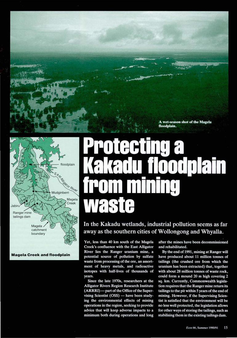
Magela catchment boundary
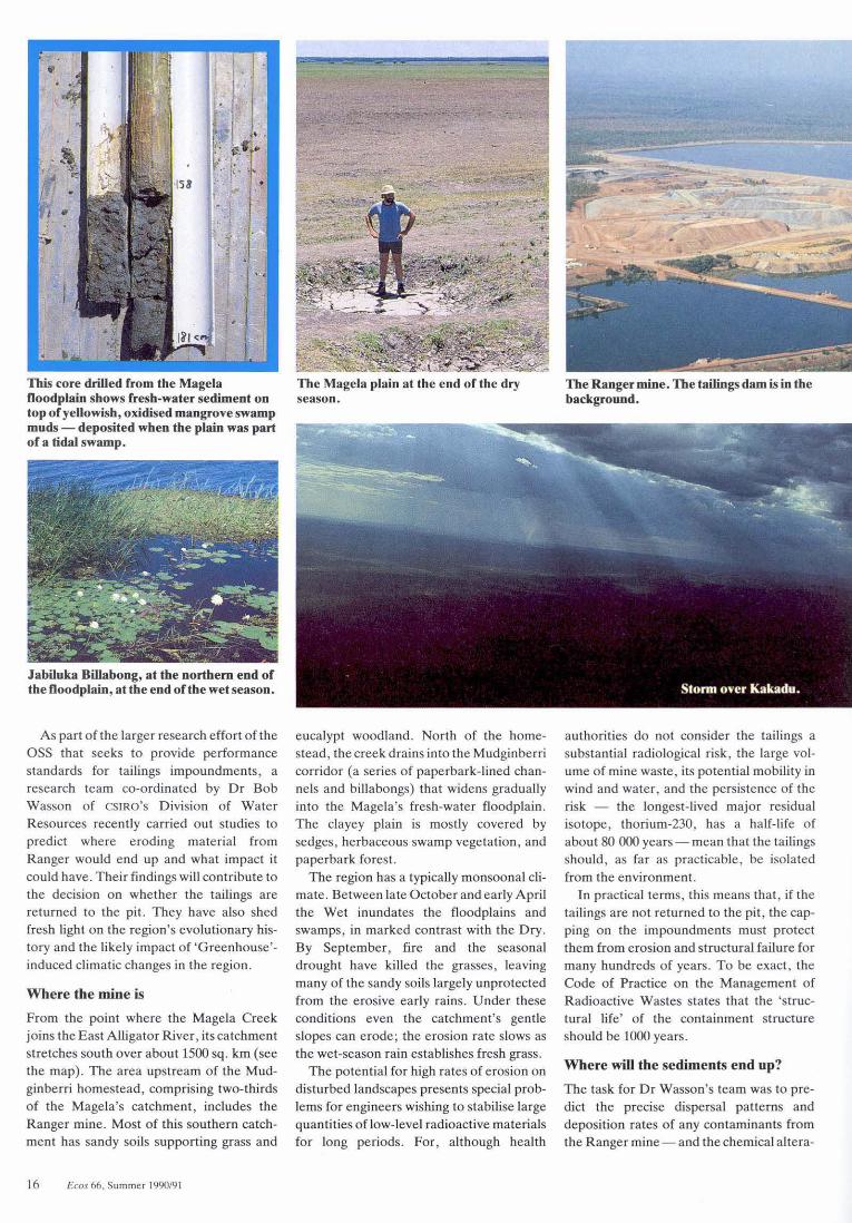
This core drilled from the Magela The Magela plain at the end of the dry Doodplain shows fresh-water sediment on season. top of yeUowish, oxidised mangrove swamp muds- deposited when the plain was part of a tidal swamp.
Jabiluka Billabong, at the northern end of the Doodplain, at the end of the wet season.
As part of the larger research effort of the ass that seeks to provide performance standards for tailings impoundments, a research team co-ordinated by Dr Bob Wasson of CSIRO's Division of Wate r Resources recently carried out studies to predict where eroding material from Ranger would end up and what impact it could have. Their findings will contribute to the decision on whether the tailings are returned to the pit. They have also shed fresh light on the region's evolutionary history and the likely impact of 'Greenhouse'induced climatic changes in the region .
Where the mine is
From the point where the Magela Creek joins the East Alligator River, its catchment stretches south over about 1500 sq . km (see the map). T he area upstream of the Mudginberri homestead , comprising two-thirds of the Magela's catchment, includes the Ranger mine. Most of this southe rn catchment has sandy soils supporting grass and
16 Ecos 66, Summer 1990/91
eucalypt woodland. North of the homestead , the creek drains into the Mudginberri corridor (a series of paperbark-lined channe ls and billabongs) that widens gradually into the Magela's fresh-water floodplain. The clayey plain is mostly covered by sedges, herbaceous swamp vegetation , and paperbark forest.
The region has a typically monsoonal climate. Between la te October and early April the Wet inundates the floodplains and swamps, in marked contrast with the Dry. By September , fire and the seasonal drought have killed the grasses, leaving many of the sandy soils largely unprotected from the erosive early rains. Under these conditions even the catchment's gentle slopes can erode; the erosion rate slows as the wet-season rain establishes fresh grass.
The potential for high rates of erosion on disturbed landscapes presents special problems for engineers wishing to stabilise large quantities of low-level radioactive materials for long periods. For, although heaJth
The Ranger mine. The tailings dam is in the background.
authorities do not conside r the tailings a substantial radiological risk, the large volume of mine waste, its potential mobility in wind and water, and the persistence of the risk - the longest-lived major residual isotope, thorium-230, has a half-life of about 80 000 years- mean that the tailings should, as far as practicable, be isolated from the environment.
In practical terms, this means that , if the tailings are not returned to the pit , the capping on the impoundments must protect them from erosion and structural failure for many hundreds of years. To be exact, the Code of Practice on the Management of Radioactive Wastes states that the 'structural life' of the containment structure should be 1000 years.
Where will the sediments end up?
The task for Dr Wasson's team was to predict the precise dispersal patterns and deposition rates of any contaminants from the Ranger mine-and the chemical altera-
tion of the eroded sediment - not only under today's typical weather patterns but for those climatic changes and extremes that could be expected to occur over the next 1000 years. That's no small job. So how did they set about it?
Dr Wasson has a particular interest in sediments. He has analysed many right across Australia and has shown that they can be valuable not only for revealing environmental histories but also for predicting the future. Unlike meteorolog.ical records that, for remote regions , often reach back a mere decade or two, sediments (if you know what to look for) can tell you what the environmental conditions were like thousands of years ago.
This knowledge of climate variability over the last two or three millennia gives a pretty good guide to what can be expected in the future . If you are an engineer with a brief to design an earthen structure that will last 1000 years in monsoon country, basing the engineering standards on these long-
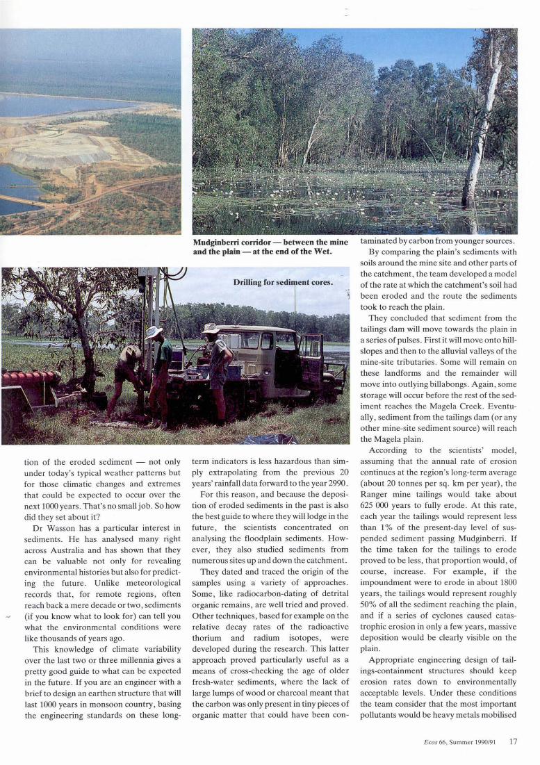
Mudginberri corridor- between tbe mine and tbe plain - at the end of tbe Wet.
term indicators is less hazardous than simply extrapolating from the previous 20 years' rainfall data forward to the year2990.
For this reason, and because the deposition of eroded sediments in the past is also the best guide to where they will lodge in the future, the scientists concentrated on analysing the floodplain sediments. However, they also studied sediments from numerous sites up and down the catchment.
They dated and traced the origin of the samples using a variety of approaches. Some, like radiocarbon-dating of detrital organic remains, are well tried and proved. Other techniques, based for example on the relative decay rates of the radioactive thorium and radium isotopes, were developed during the research. This latter approach proved particularly useful as a means of cross-checking the age of older fresh-water sediments, where the lack of large lumps of wood or charcoal meant that the carbon was only present in tiny pieces of organic matter that could have been con-
taminated by carbon from younger sources. By comparing the plain's sediments with
soils around the mine site and other parts of the catchment , the team developed a model of the rate at which the catchment's soil had been eroded and the route the sediments took to reach the plain.
They concluded that sediment from the tailings dam will move towards the plain in a series of pulses. First it will move onto hillslopes and then to the alluvial valleys of the mine-site tributaries. Some will remain on these landforms and the remainder will move into outlying billabongs. Again , some storage will occur before the rest of the sediment reaches the Magela Creek. Eventually, sediment from the tailings dam (or any other mine-site sediment source) will reach the Magela plain.
According to the scientists' model , assuming that the annual rate of erosion continues at the region's long-term average (about 20 tonnes per sq. km per year), the Ranger mine tai lings would take about 625 000 years to fully erode. At this rate, each year the tailings would represent less than 1% of the present-day level of suspended sediment passing Mudginberri. If the time taken for the tailings to e rode proved to be less, that proportion would , of course, increase. For example, if the impoundment were to erode in about 1800 years, the tailings would represent roughly 50% of all the sediment reaching the plain , and if a series of cyclones caused catastrophic erosion in only a few years, massive deposition would be clearly visible on the plain.
Appropriate engineering design of tailings-containment structures should keep erosion rates down to environmentally acceptable levels. Under these conditions the team consider that the most important pollutants would be heavy metals mobilised
Ecos 66, Summer 1990/91 17

Tailings dam seepage
In addition to possible long-term pollution problems from eroded sediments , any seepage from the Ranger uranium mine tail ings dam could also pollute the region's groundwater.
To test whether this pollution was occurring, Or Brian Gulson, Ms Karen Mizon, and Mr Michael Korsch , of CSIRO's Division of Exploration Geoscience, and Or Barry Noller of the Office of the Supervising Scientist examined the groundwater taken from bores around the dam.
The scientists applied the ' lead isotope fingerpr inting' method. This makes use of the fact that the four isotopes of lead (three are the stable end-products of radioactive decay of uranium and thorium) are found in strikingly different proportions in uranium ore from those in the 1800-million-year-old
(made available to plants) by their contact with saturated soi ls.
With samples of tailings taken from the dam, the scientists studied how the metals reacted when mixed with soil samples from the plain. They fou nd that , at the concentrations of tailings that would reach the plain assuming the natural long-term e rosion rate, only lead and radium-226 would show any increase in the quantity mobilised, and the increase would be very small . But if the total e rosion occurred in one-third of the time, then the additiona l mobilisation would rise substantially and would involve manganese and uranium as well as lead and radium-226. Under those circumstances the increase in available heavy metals may well be sufficient to have some bio logical impact.
In summary , the study indicates that if the taili ngs e rode at the natural denudation rate, the plain's plant and animal life will not be affected. Higher rates may produce a different outcome. Or Wasson and his colleagues believe this is a st rong argument for building the tailings impoundment in a manner that mimics the origina l landscape - concave slopes formed from a natura l grading of particle sizes.
Back to tbe future
With prospects of the greenhouse effect altering weather patte rns and raising sea levels in the next century or so, designing the impoundment to make it robust enough to withstand climatic changes over the next thousand years is obviously a challenge. Fortunately, the plain's sediment history (revealed by combining radionuclide dating with an analysis of pollen), when linked to
18 Ecos 66. Summer 1990/9 1
rocks that surround the deposit. The scientists were able to measure the isotopes in trace amounts of lead (parts per trillion) in water from the tailings dam and from bores surrounding the dam.
Six years after mining commenced they found , apart from a possible minor leak in the southern wall , no movement of heavy metals into the adjacent groundwater.
Recently - 5 years a fter the original measurements- the project was repeated. As Ecos went to press, results were being assessed.
Lead isotopes as seepage indicators around a uranium tailings dam. B.L. Gulson, K.J. Mizon, M.J. Korsch, and B.N. Noller. Environmental Science and Technology, 1989, 23,290-4.
known global patterns of previous climate changes such as the Medieval Warm Period and the Little Ice Age, gives an excellent indication of how the Magela plain has responded to climatic change over the last few thousand years.
The team's major discovery was that , in their current form , the Magela fresh-water wetlands are quite young, first appearing somewhere between 1500 and 1000 years ago. The pollen evidence (and that of populations of estuarine and fresh-water diatoms) shows that, previously, the plain formed part of a large tida l swamp dominated by mangroves. The researchers con-
The research team OSS CSIRO Jon East Gary Hancock Arthur Johnston Patrick McBride Reiner Marten Paul Martin Andrew Murray Barry Noller John Pfitzner
RobinClark JoanGuppy FredLeany Oaphne Mahon BobWasson I an Willet University of Sydney Robin Warner
sider that the reason for the change was the end, about 6000 years ago, of the trend to rising sea levels; fresh-water sedimentation then raised the Magela plain above tidal inundation . The transition appears to have occurred very suddenly, sedime nt cores indicating a sharp dividing line between the past and present ecosystems.
Closely following the change came an increase in the population of Aborigines living in the vicinity, who would have found the wetlands a rich food source. Perhaps, in turn, they influenced the vegetation through the use of fire. The record in the sediment shows that charcoal started appearing about 700-800 years ago.
And the future? As Earth warms with rising C0
2, the sea level will rise- perhaps by
between 30 and 70 cm over the next 100 years. At the same time, the Australian monsooo is likely to intensify and the length of the wet season and its accompanying rainfall will increase. The closest likeness to these conditions, as recorded in the plain 's sediments, is the Medieval Warm Period. Sedimentation rates differed little then from those of coole r periods.
As the evidence shows that the rate of natural sedimentation is not very sensitive to climate change , future global warming is unlikely to have much impact on it , although more frequent and more intense cyclones may deliver tailings to the plain at a faster rate. These pollutants will probably not come into contact with sea water because the predicted rise of less than a metre is un likely to reconnect the sea to the upstream part of the pla in where most oft he tailings would lodge.
David Brett
More about tbe topic
Modern sedimentation and late Quaternary evolution of the Magela Creek Pla in . R.J. Wasson (ed) . Reporuo the Office of Supervising Scientist, 1990.
'Ranger Uranium E nvironmental Inquiry, Second Report. ' (Australian Government Publishing Service: Canberra 1977.)
Erosion times, and tailings in sediment tailings in surface sediments (%) 100 500 -
---------------------------------------------------------------10- 1000
erosion time (years)
10 20 distance along the plain (km)
H Ranger mine tailings erode at the region's long-term average rate they will take more than 600 000 years to fuUy erode and the ta ilings will represent a very small fraction of Doodplain surface sediments. The graph shows the scientists' estimates of how accelerated erosion rates would increase the tailings' presence in the sediments.