Embed Size (px)
Citation preview

M1 Princes Motorway,Mount Ousley InterchangeREF submissions reportRoads and Maritime Services I April 2018

THIS PAGE LEFT INTENTIONALLY BLANK

1 M1 Princes Motorway, Mount Ousley Interchange Submissions Report
Roads and Maritime Services
M1 Princes Motorway, Mount Ousley Interchange Submissions report April 2018
Prepared by Jacobs and Roads and Maritime Services
COPYRIGHT: The concepts and information contained in this document are the property of Roads and Maritime Services NSW (Roads and Maritime). Use or copying of this document in whole or in part without the written permission of Roads and Maritime constitutes an infringement of copyright.

2 M1 Princes Motorway, Mount Ousley Interchange Submissions Report
Document controls
Approval and authorisation
Title M1 Princes Motorway, Mount Ousley Interchange Submissions Report
Accepted on behalf of Roads and Maritime NSW by
Tim Webster Project Development Manager
Signed
Dated 16/03/2018
Document status
Document status Date Prepared by Reviewed by
Rev00 9/2/2018 Stuart Tweedy Tim Colman
Rev01 19/2/2018 Stuart Tweedy Tim Colman
Rev02 2/3/2018 Tim Colman Aaron Bowden
3 M1 Princes Motorway, Mount Ousley Interchange Submissions Report
Executive summary
NSW Roads and Maritime Services propose to upgrade the M1 Princes Motorway and Mount Ousley Road intersection to a grade-separated interchange that would improve road safety, travel times and cater for the efficient movement of future traffic and freight growth. The key features of the proposal include an overpass between Mount Ousley Road, the M1 Princes Motorway and the University of Wollongong including two roundabouts, a heavy vehicle bypass lane and heavy vehicle exit ramp, two heavy vehicle safety ramps, a commuter carpark and active transport connections.
A four week consultation period took place from 16 November to 15 December so that Roads and Maritime could gather feedback on the Review of Environmental Factors (REF) published in November 2017. As a result of this consultation, Roads and Maritime received a total of 130 submissions from 115 people with a total of 267 separate comments. A total of 24 submissions were received by email, 30 via feedback forms (including feedback from residents invited to the noise consultation presentations), two via formal letters, five via phone calls and 69 through the online mapping tool on the Roads and Maritime website.
Consultation sessions and tools included: 1. Information sessions in the Crown Street Mall and Fairy Meadow Community Centre.2. An online mapping tool that allowed stakeholders to submit comments directly onto a
project area map.3. Targeted noise consultation sessions held at TAFE NSW Illawarra campus4. A follow up phone survey with residents who have been identified as eligible for
consideration of additional noise management measures.5. Roads and Maritime project website
Roads and Maritime has reviewed and summarised all of the feedback received, and provided responses to the issues raised in this report. The project team is also using the community and stakeholder feedback as input to further develop the proposal’s design where appropriate.
Summary of key issues In general, the submissions were in support of the proposal or its objectives. The issues raised during the consultation period focussed mostly on the impacts of the proposed design on local traffic and the impacts to the local community during construction.
The main issues raised and their responses are below.
Traffic and road safety Issues related to traffic and road safety were raised in 51 per cent of the submissions. In particular:
The northbound entry ramp from Mount Ousley Road onto the Princes Motorway and interaction with heavy vehicles on the uphill grade.
The northbound entry ramp has its own lane to the top of Mount Ousley, a distance of about five kilometres. This means vehicles are not required to merge at the end of the ramp and have time to select their preferred lane when there are safe gaps in the traffic stream.

4 M1 Princes Motorway, Mount Ousley Interchange Submissions Report
• Safety of heavy vehicles travelling eastbound on Mount Ousley Road and the eastboundapproach speeds to the Gaynor Avenue roundabout.
The concept design has been modified to address this issue as described in the DesignChanges section below. Two new heavy vehicle safety ramps would also be provided at thebase of Mount Ousley to improve safety.
• Usage of the commuter car park by university students.
The commuter car park is proposed for use by commuters who generally arrive early in themorning, around 5 am or earlier, reducing the potential for competition with university students.
• Travel delays on the southbound service road as this new section of road requires vehiclesaccessing the Princes Motorway, from Mount Ousley Road, to travel through the UniversityAvenue interchange rather than merging straight onto the motorway.
The proposed new northern access to the University at the Mount Ousley interchange wouldsubstantially reduce delays at the University Avenue interchange meaning delays forsouthbound motorists to access the motorway would be acceptable.
The proposed southbound service road is designed to improve safety by removing the need forvehicles to weave between traffic when entering and exiting the motorway between MountOusley Road and University Avenue. It would also remove the impact of queuing at UniversityAvenue on the flow of traffic on the motorway.
The combination of these proposed changes would result in an overall improvement to trafficflow at the University Avenue interchange and the M1 Princes Motorway.
Traffic impacts during construction The issue of traffic impacts during construction was raised in 5 per cent of submissions focussing mainly on potential delays and disruptions and communication with road users.
Overall the proposal would have minimal impacts on local roads and access during construction. Construction activities would be staged to minimise impacts on road capacity through the course of construction, with local residents and road users informed of progress via the Roads and Maritime website, through the use of variable message signs and resident notifications as required.
Two lanes of traffic would be kept open in both directions on the M1 Princes Motorway, with the exception of some lane restrictions where required during limited night work.
The right turn from Mount Ousley Road to the Princes Motorway would be restricted for a period of up to three months. The shortest detour route would be via the University Avenue interchange resulting in a total detour distance of 2.6 kilometres.
Design Aspects of the design were raised in 35 per cent of the submissions, with one third of those submissions only offering support of the proposed design. Those that raised issues were concerned about:
• Pedestrians and cyclist safety, in particular the crossing of the southbound service road andconnections to local roads.

5 M1 Princes Motorway, Mount Ousley Interchange Submissions Report
The concept design has been modified to address the crossing of the southbound service road as described in the Design Changes section below. Active transport links on local roads are managed by Wollongong City Council and would be considered when Council updates its bike plan later in 2018.
• Funding should focus on new roads coming from the escarpment into the Illawarra, and theprovision of a third southbound lane.
In accordance with NSW Government strategies, short-term priorities focus on improving theexisting M1 Princes Motorway and Mount Ousley Road, while new roads are long-termpriorities.
The third southbound lane is a separate proposal and will not be built through this project,however the Mount Ousley interchange has been designed to cater for a third southbound lanein the future.
Noise and Vibration Noise issues were raised in 35 per cent of submissions, mainly relating to traffic noise from trucks during normal motorway operations and how this was going to be mitigated. Two submissions raised concerns around the impacts of noise and vibration during construction.
Roads and Maritime is proposing a range of noise mitigation measures including noise walls and at-property treatments.
Based on feedback obtained through the targeted noise consultation, the following noise management strategy is proposed:
• A five metre noise wall along the northern side of the M1 Princes Motorway and thesouthern side of Dumfries Avenue, between the end of the existing noise wall and FoothillsRoad.
• A five metre noise wall along the southern side of the M1 Princes Motorway and thenorthern side of Falder Place, between the mid-way point of Binda Street and the proposedwestern roundabout.
• A 3.5 metre noise wall along the southern side of Mount Ousley Road, between GowanBrae Avenue and the cul-de-sac at the western end, and continuing to the south for about50 metres to shield the properties at the western end of Mount Ousley Road.
• At-property treatments for residential receivers where noise levels are still predicted toexceed road traffic noise criteria.
The final design of noise barriers will be confirmed in the detailed design phase, with consideration to the above issues raised during consultation. At-property treatments will also be determined during the detailed design phase.
• Impact of noise and vibration during construction.The majority of construction would be undertaken during standard day time hours.However, some limited out of hours work would be required. A Noise and VibrationManagement Plan (NVMP) will be prepared and implemented during construction. Thisdocument will include mitigation measures for planned night time or weekend work.

6 M1 Princes Motorway, Mount Ousley Interchange Submissions Report
Loss of habitat, landscaping and urban design Eight per cent of submissions raised issues around landscaping and design, mainly focussing on the amount of clearing required and impacts on amenity.
During construction, the proposal requires clearing of about: • 7.58 hectares of two non-threatened plant community types.• 5.05 hectares of roadside and urban plantings.• One hectare of weed-dominated vegetation.
Offsets or supplementary measures would be provided to manage the impacts of this clearing. The proposal area would also be improved and landscaped with native vegetation unique to the lower Illawarra escarpment and coastal plain once construction has been completed.
Design changes Following consultation with the community, Roads and Maritime will introduce changes to the final concept and detailed design. These are:
• Shortening the heavy vehicle exit-ramp (onto Mount Ousley Road) by connecting it to theeastern roundabout, creating a fifth leg at the roundabout. This would control the speeds ofheavy vehicles travelling eastbound on Mount Ousley Road and improve safety. Thischange would also remove the need for heavy vehicles accessing University Avenue fromthe Princes Motorway southbound to detour via Mount Ousley Road and make a U Turn atGaynor Avenue or Princes Highway. Minor modifications to the Gaynor Avenue roundaboutwould also be made to address current safety concerns with eastbound approach speeds.
• Extending the shared path bridge over Mount Ousley Road to connect with the bridge overthe Princes Motorway, removing the need for pedestrians and cyclists to cross thesouthbound on-ramp.
These design changes are described in detail in Section 3 of this report.
Additional assessment Two issues were raised during the consultation period that required additional assessment. These were the potential impacts on:
• Traffic as a result of the proposed change to the heavy vehicle exit ramp and the easternroundabout. Additional traffic assessment has shown that the eastern roundabout wouldcontinue to operate satisfactorily with the proposed design changes.
• The internal road network at the University of Wollongong as a result of the proposed newnorthern access. Additional traffic assessment has shown that based on travel times, itwould still be quicker to travel via Northfields Avenue and the Princes Motorway, rather thanusing the internal road network of the University to access the proposed interchange.
These two issues are addressed in further detail in Section 4 of this report.
Environmental safeguards The REF proposed several environmental safeguards and no further changes are recommended in order to avoid or minimise any potential impacts associated with the design changes discussed above. However, following consideration of the matters raised in the public submissions and consultation with agencies, one additional environmental safeguard (SE4) has been included in relation to the extension of the University of Wollongong Safe Zone for pedestrians and cyclists.

7 M1 Princes Motorway, Mount Ousley Interchange Submissions Report
An updated consolidated set of environmental safeguards is provided in Table 5.1 of this report.

8 M1 Princes Motorway, Mount Ousley Interchange Submissions Report
Contents
Executive summary ........................................................................................................................ 3
Contents .......................................................................................................................................... 8
1 Introduction and background .................................................................................................. 9
1.1 The proposal ....................................................................................................................... 9
1.2 REF display and consultation ........................................................................................... 13
1.3 Noise consultation ............................................................................................................ 13
1.4 Purpose of the report ........................................................................................................ 14
2 Response to issues ................................................................................................................ 15
2.1 Overview of issues raised ................................................................................................. 15
2.2 Noise ................................................................................................................................ 16
2.3 Traffic and road safety ...................................................................................................... 19
2.4 Design .............................................................................................................................. 31
2.5 Construction impacts ........................................................................................................ 35
2.6 Air quality .......................................................................................................................... 37
2.7 Loss of habitat .................................................................................................................. 37
2.8 Landscape and urban design ........................................................................................... 38
3 Design changes ....................................................................................................................... 40
3.1 Gaynor Avenue roundabout ............................................................................................. 40
3.2 Heavy vehicle off ramp ..................................................................................................... 40
3.3 Pedestrian bridge at eastern roundabout ......................................................................... 41
4 Additional assessment ........................................................................................................... 44
4.1 Additional traffic assessment ............................................................................................ 44
4.2 Impacts on internal campus road network ........................................................................ 45
4.3 Environmental safeguards ................................................................................................ 45
5 Environmental management .................................................................................................. 46
5.1 Environmental management plans (or system) ................................................................ 46
5.2 Summary of safeguards and management measures ...................................................... 47
6 References ............................................................................................................................... 67
Appendix A Flyer notifying REF display Appendix B Respondents

9 M1 Princes Motorway, Mount Ousley Interchange Submissions Report
1 Introduction and background
1.1 The proposal The proposal is located at the base of the Illawarra escarpment at Mount Ousley, where the M1 Princes Motorway enters Wollongong via an existing at-grade intersection with Mount Ousley Road, as shown in Figure 1-1. The key objectives of the proposal are to improve road safety, improve travel time and efficiency, to provide for the growing freight task, and to enhance accessibility to and from the M1 Princes Motorway and the Wollongong CBD.
The main features of the proposal, illustrated in Figure 1-2 include:
• An overpass from Mount Ousley Road to allow northbound traffic to safely access theM1 Princes Motorway.
• A heavy vehicle only bypass lane, to separate heavy vehicles from general southbound trafficon the M1 Princes Motorway and light vehicles exiting at Mount Ousley Road.
• A southbound heavy vehicle only exit ramp to Mount Ousley Road, to separate heavy and lightvehicles exiting the M1 Princes Motorway to Mount Ousley Road.
• A new entry to the University of Wollongong from the M1 Princes Motorway, for bothnorthbound and southbound vehicles, via a new overpass from Mount Ousley Road and a new(northbound) motorway exit ramp.
• A new northbound exit from the University of Wollongong to the M1 Princes Motorway and toMount Ousley Road via the new overpass.
• New roundabouts at Mount Ousley Road, servicing the new entrance to the University ofWollongong and for vehicles exiting the M1 Princes Motorway (from northbound andsouthbound lanes) at Mount Ousley Road.
• A new southbound service road, which would replace the existing southbound access from theM1 Princes Motorway to University Avenue.
• Two new heavy vehicle safety ramps.• A new pedestrian and cyclist bridge over Mount Ousley Road connecting to the bridge over the
M1 Princes Motorway, and a new shared path connecting suburbs to the north with theUniversity of Wollongong and the TAFE NSW Wollongong campus.
• Upgrades to the existing pedestrian bridge over the M1 Princes Motorway atNorthfields Avenue, including extending the bridge span and changes to the eastern accessramp.
• A new commuter car park, relocated to the southern side of the M1 Princes Motorway, withadditional formalised parking spaces and a traffic incident response facility.
• New noise walls along the M1 Princes Motorway and Mount Ousley Road as follows:- A five metre noise wall along the northern side of the M1 Princes Motorway and the
southern side of Dumfries Avenue, between the end of the existing noise wall and FoothillsRoad.
- A five metre noise wall along the southern side of the M1 Princes Motorway and thenorthern side of Falder Place, between the mid-way point of Binda Street and the proposedwestern roundabout.
- A 3.5 metre noise wall along the southern side of Mount Ousley Road, between GowanBrae Avenue and the cul-de-sac at the western end and continuing to the south for about50 metres to shield the properties at the western end of Mount Ousley Road.

10 M1 Princes Motorway, Mount Ousley Interchange Submissions Report
- At-property treatments for residential receivers where noise levels are still predicted toexceed road traffic noise criteria.
A more detailed description of the proposal, including a discussion of the need for the proposal and its objectives, can be found in Chapters 1 and 2 of the M1 Princes Motorway Mount Ousley Interchange Review of Environmental Factors (REF) prepared by Roads and Maritime in November 2017. The REF can be found on the project website: http://www.rms.nsw.gov.au/projects/illawarra/m1-princes-motorway/m1-interchange

11 M1 Princes Motorway, Mount Ousley Interchange Submissions Report
Figure 1.1 | Location of the proposal

12 M1 Princes Motorway, Mount Ousley Interchange Submissions Report
Figure 1.2 | The proposal

13 M1 Princes Motorway, Mount Ousley Interchange Submissions Report
1.2 REF display and consultation Roads and Maritime prepared a REF to assess the environmental impacts of the proposed work. The REF was publicly displayed for four weeks between 16 November and 15 December 2017 at four locations as detailed in Table 1-1. Community information sessions were held where members of the community could discuss the proposal with the project team at three additional locations (also listed in Table 1-1).
The REF was placed on the Roads and Maritime project website and made available for download. The display locations and website link were advertised in the Illawarra Mercury and on the Roads and Maritime Facebook page.
Flyers were delivered to 3,500 households near the proposal area and emails were sent to all registered stakeholders notifying them that the REF was on display and directing them to the project website for further information.
The flyer and the community update that were issued to publicise the REF and its associated public display are attached to this report in Appendix A.
Table 1-1 Display locations
Location Address Dates
University of Wollongong Library
University of Wollongong, Northfields Avenue, Keiraville
Static display (16 November to 15 December)
Wollongong City Council 41 Burelli Street, Wollongong Static display (16 November to 15 December)
Roads and Maritime Services Wollongong office
90 Crown Street, Wollongong Static display (16 November to 15 December)
Service NSW Centre, Wollongong
90 Crown Street, Wollongong Static display (16 November to 15 December)
Crown Street Mall, Friday Markets
Crown Street Mall, Wollongong CBD
Friday 17 November, 10.00 am to 2.00 pm
Fairy Meadow Community Centre
Corner Princes Highway and Cambridge Avenue, Fairy Meadow
Monday 20 November, 4.00 pm to 7.00 pm Saturday 9 December, 10.00 am to 2.00 pm
Wollongong Central Shopping Centre
Keira Street, Wollongong Saturday 2 December, 10.00am to 2.00pm
1.3 Noise consultation Roads and Maritime Services undertook targeted consultation with residents and property owners identified as eligible for consideration for noise management measures. Letters were delivered to the households identified, inviting them to attend a presentation which provided noise simulations of future noise levels with and without a range of noise management measures.

14 M1 Princes Motorway, Mount Ousley Interchange Submissions Report
These presentations offered an opportunity for individual households to provide comment on noise management measures, ask questions and provide Roads and Maritime with a better understanding of what was important to residents in developing a noise management strategy for the proposal. Sound lab sessions were held between 11 and 15 December 2017 at the TAFE NSW Wollongong campus.
A follow up phone survey was completed between 19 and 27 February 2018 to provide the same identified households an additional opportunity to give feedback on the proposed noise management strategy. Those who were unable to attend the noise simulation sessions were also given an opportunity to provide feedback.
1.4 Purpose of the report This submissions report relates to the REF prepared for the M1 Princes Motorway, Mount Ousley Interchange, and should be read in conjunction with that document.
The REF was placed on public display and submissions relating to the proposal and the REF were received by Roads and Maritime. This submissions report summarises the issues raised and provides responses to each issue (Chapter 2). It also details further design work (Chapter 3) and environmental assessment (Chapter 4) that has been completed to address comments received during the consultation period.
15 M1 Princes Motorway, Mount Ousley Interchange Submissions Report
2 Response to issues
During the consultation period (16 November to 15 December 2017), Roads and Maritime received 130 submissions from 115 people and a total of 267 separate comments accepted. A total of 24 submissions were received by email, 30 via feedback forms (including feedback from residents invited to the noise simulation presentations), two via formal letters, five via phone calls, 69 via the online consultation tool on the Roads and Maritime website.
All but three of the submissions received were from individual community members or small groups of community members (such as family/household groups). One submission was received from NSW Ports (corporation; not government-owned), one submission was received from the University of Wollongong and one was received from Neighbourhood Forum 5.
Appendix B itemises the submissions and allocates each a unique submission number. The table also indicates where the issues raised in each submission have been addressed in sections 2.2 to 2.8 of this report.
2.1 Overview of issues raised Each submission has been examined individually to understand the issues being raised. The issues raised in each submission have been identified and collated, and corresponding responses to the issues have been provided. Where similar issues have been raised in different submissions, only one response has been provided. The issues raised, and Roads and Maritime’s response to these issues forms the basis of this chapter.
About 20 per cent of all submissions clearly stated support for the proposal, particularly around the improvements to safety. One business group showed particular support for the proposal of the heavy vehicle bypass lane and heavy vehicle exit ramp at Mount Ousley Road.
There were two submissions objecting to the proposal in its entirety, one on the grounds that upgrading rail access between Wollongong and Sydney would be a better use of public investment, the other giving no specific grounds for objection. The remaining submissions suggested changes or queried one or more elements of the proposal.
Comments raised in the submissions focussed on the following key issues: • Road traffic noise during construction and operations.• Traffic and road safety.• The design of the proposal and how it will guide motorists through the interchange to their
destinations.• Construction impacts.• Air quality.• Loss of habitat.• Landscaping and urban design.
The majority of the comments related to the design of the proposal and to traffic and road safety.
Following sections of this report will discuss these issues in more detail.
16 M1 Princes Motorway, Mount Ousley Interchange Submissions Report
2.2 Noise Noise issues were raised in 35 per cent of submissions, mainly relating to traffic noise from trucks during normal motorway operations and how this was going to be mitigated. Two submissions raised concerns around the impacts of noise and vibration during construction.
2.2.1 Operational noise and noise mitigation
Submission number(s) 3, 5, 9, 10, 12, 24, 29, 34, 40, 51, 52, 57, 59, 64, 69, 70, 84, 96, 100, 103, 110, 113, 114, 116, 117, 118, 119, 121, 122, 123, 124, 126, 127, 128, 129
Issue description • How has operational traffic noise, including truck noise been measured and has the
noise assessment considered growth in traffic?• What measures are being implemented to mitigate operational road noise affecting local
residents particularly with traffic lanes moving closer to residences?
Response In November 2016, Roads and Maritime conducted noise monitoring surveys to measure the current level of noise around the proposal area. This consisted of one week of continuous (day and night) noise measurements at six locations. The noise assessment addressed the impacts of additional traffic from future developments, including growth in freight, once the interchange is built. It also assessed noise impacts from the predicted traffic volumes 10 years after the new interchange opens.
Residential and other sensitive receivers around the proposal currently experience high road traffic noise from the existing M1 Princes Motorway and Mount Ousley Road, including some locations in Falder Place, Dumfries Avenue and Mount Ousley Road where noise levels exceed the acute road traffic noise criteria.
Noise modelling of the proposed design estimates that less than one per cent of receivers in the study area would experience a noticeable increase in noise levels (defined as more than a 2 dB increase in noise levels) before noise mitigation. Roads and Maritime is proposing a range of noise mitigation measures including noise walls and at-property treatments.
Based on feedback obtained through the targeted noise consultation, the following noise management strategy is proposed:
• A five metre noise wall along the northern side of the M1 Princes Motorway and thesouthern side of Dumfries Avenue, between the end of the existing noise wall and FoothillsRoad. Of the 12 respondents affected by this noise wall, seven supported the provision of afive metre noise wall, two preferred a higher noise wall, and three preferred a lower noisewall.
• A five metre noise wall along the southern side of the M1 Princes Motorway and thenorthern side of Falder Place, between the mid-way point of Binda Street and the proposedwestern roundabout. Of the seven respondents affected by this noise wall, five supportedthe provision of a five metre noise wall and two preferred a lower noise wall.
• A 3.5 metre noise wall along the southern side of Mount Ousley Road, between GowanBrae Avenue and the cul-de-sac at the western end, and continuing to the south for about50 metres to shield the properties at the western end of Mount Ousley Road. Of the 11

17 M1 Princes Motorway, Mount Ousley Interchange Submissions Report
respondents affected by this noise wall, eight supported the provision of a 3.5 metre noise wall and three preferred no noise wall.
• At-property treatments for residential receivers where noise levels are still predicted toexceed road traffic noise criteria.
Those who wanted: • A higher noise wall wanted the highest wall possible in order to reduce noise.• A lower noise wall, were more concerned with the visual impacts of a high noise wall
including overshadowing and blocking views.• No noise wall, were concerned with the potential impacts of the noise wall on their property
value and concerned with the potential for graffiti.
The final design of noise barriers will be confirmed in the detailed design phase, with consideration to the above issues raised during consultation. At property treatments will also be determined during the detailed design phase.
A full discussion of construction and operational noise impacts and proposed mitigations is given in section 6.2 of the REF.
Submission number(s) 52, 56
Issue description How will the removal of vegetation impact noise levels for residents?
Response Research has found that 10 to 20 metres of dense trees (tree spacing less than 0.5 metre) can reduce traffic noise by 2 to 3 dB (Peng et al, 2014). Residents in areas with less than this width or density of trees are unlikely to notice any change in noise as a result of vegetation removal.
During construction, the proposal potentially requires clearing about 7.58 hectares of two plant community types (which are not listed as threatened under the Biodiversity Conservation Act 2016), 5.05 hectares of roadside and urban plantings, and one hectare of weed dominated vegetation.
The proposal area would be improved and landscaped with vegetation native to the lower Illawarra escarpment and coastal plain following construction. Noise barriers and at-property treatments would be provided to mitigate noise impacts.
Submission number(s) 37
Issue description What are the expected noise impacts from construction and operation of the proposal at University of Wollongong?
Response Given the large number of buildings at the University of Wollongong campus next to the proposed work area, the potential noise impacts to these buildings are predicted to exceed established noise guidelines when noise intensive work is carried out in close proximity. These buildings are likely to have been constructed with noise attenuating materials, which would minimise the impacts of noise.

18 M1 Princes Motorway, Mount Ousley Interchange Submissions Report
Acoustic properties of these buildings, potential noise impacts and required management measures would be further investigated during the detailed design phase. A Noise and Vibration Management Plan (NVMP) will be prepared and implemented as part of the Construction Environmental Management Plan (CEMP). The NVMP will generally follow the approach in the Interim Construction Noise Guideline (ICNG) (DECC, 2009).
In the operational phase, the proposal is predicted to result in a minor reduction in noise levels for some receivers at the University of Wollongong. This is due to vehicles being moved further away from these receivers, and the construction of the Mount Ousley Road retaining wall creating a barrier against noise generated by the M1 Princes Motorway. Receivers close to the proposed new northern access to the University of Wollongong would however experience a small increase in noise levels.
A full discussion of construction and operational noise impacts and proposed mitigations is available in section 6.2 of the REF.
Submission number(s) 7, 9, 122
Issue description
As part of this project, will Roads and Maritime use noise camera technology to monitor the noise from heavy vehicle exhaust brakes?
Response Roads and Maritime has developed noise camera technology to detect vehicles that emit excessive engine compression brake noise. This technology has been trialled at Mt Ousley on the South Coast and Woolgoolga on the North Coast. A relocatable noise camera system has also been developed and trialled.
Roads and Maritime however has no legal power to issue any fines relating to heavy vehicle noise and vibration levels as there are no regulations limiting exhaust brake noise. Existing signs are advisory only. In response to community concerns, the NSW Government is working on a range of education and enforcement measures to reduce noise from freight vehicles.
Transport for NSW and Roads and Maritime are working closely with other states and territories and the National Transport Commission to implement a national standard for engine brakes. This standard was approved by the Australian Transport Council in 2007 and reviewed by the National Transport Commission in May 2013.
The National Transport Commission may prepare amendments to the National Heavy Vehicle Legislation to provide for regulation of engine brake noise. The NSW Government is following this process closely. A state wide rollout of the noise camera system will be considered to assist in enforcing the new standard when legislation enabling its regulation is in place.
2.2.2 Construction noise
Submission number(s) 36, 40, 120
Issue description How much disruption will be caused to residents outside of standard construction hours?

19 M1 Princes Motorway, Mount Ousley Interchange Submissions Report
Response The majority of construction would be undertaken during standard day time hours.
Some limited out of hours work would however be required. Work during out of hours periods would likely result in high noise impacts at the nearby receivers. This would include work at the northern end of the project, near Dumfries Avenue and Falder Place, where existing noise barriers are required to be removed and relocated to accommodate the work. The southern end of the project near Irvine Street would also require out of hours work where drainage improvements are required at the northbound on-ramp to the Princes Motorway.
Where construction noise is predicted to exceed noise management levels, including planned night time or weekend work, this would be mitigated through construction noise management techniques outlined in an out of hours work procedure prepared in accordance with the Roads and Maritime Construction Noise and Vibration Guideline (2016).
The proposed construction method and sequence, including work that would be conducted outside standard working hours, are described in section 3.3 of the REF.
2.3 Traffic and road safety Traffic and road safety was raised in 51 per cent of the submissions and was the category that had the most responses. Within this category, respondents raised matters relating to:
• Merging and weaving, in particular the potential for conflict between light and heavyvehicles.
• Heavy vehicle safety including transportation of dangerous goods.• Operation of the heavy vehicle bypass.• Impacts on the Gaynor Avenue roundabout.• Car parking including local roads and the commuter car park.• Pedestrians and cyclists.• Changed access to University Avenue including access from Mount Ousley Road to the
Princes Motorway southbound via University Avenue.• Ancillary facilities for emergency and maintenance vehicles.• Operation of the eastern roundabout.• Signage and wayfinding.• Access to and from the University of Wollongong.
2.3.1 Merging and weaving
Submission number(s) 4, 19, 25, 39, 46, 66, 67, 71, 75, 77, 78, 81, 86, 87, 102, 108
Issue description • Will there be conflicts between heavy and light vehicles on the Mount Ousley Road/M1
Prince Motorway northbound on-ramp, where trucks are slowing down due to the uphillgrade?
• One submission suggested the addition of a northbound on-ramp landing in the right handlane of the M1 Princes Motorway.
Response An assessment has been completed using the Highway Capacity Manual (HCM 2010) near motorway entry and exit ramps where weaving would occur. A performance measure for on-ramps

20 M1 Princes Motorway, Mount Ousley Interchange Submissions Report
of a maximum average speed difference of no more than 10 km/h between adjacent lanes has been adopted. Lateral lanes will be long enough to allow for five seconds of travel at the posted speed to allow merging vehicles to find gaps in traffic.
Traffic modelling at this location indicates that trucks in the centre lane would be travelling at 70 km/h while cars would be travelling at 72 km/h, indicating that truck speeds would be similar to car speeds until 200 metres further north, where the grade increases and trucks would start to lose speed.
The proposed northbound on-ramp will join the M1 Princes Motorway as an additional lane rather than a merge. There will be no requirement for vehicles from Mount Ousley Road to merge until the Picton Road interchange, a distance of five kilometres, meaning vehicles entering the motorway would have sufficient time to find gaps in the traffic stream and select an appropriate lane before reaching Picton Road.
Options to construct ramps in the centre of the motorway were considered during the options selection phase and have been avoided due to the increased constructability and work health safety risks of doing major construction for lengthy periods of time in the centre of the motorway at the base of a steep hill. The preferred option has been selected as the majority of work can be constructed separate from the motorway with improved safety and traffic management outcomes.
Submission number(s) 2, 4, 40, 44
Issue description Should the length of the University Avenue on-ramp to the M1 Princes Motorway southbound be increased due to the higher volume of vehicles using this merge?
Response Increasing the length of the existing merge is not proposed as it would not meet design guidelines due to the entry of Memorial Drive lanes, which start 122 metres south of the end of the merge. The existing southbound on-ramp merge length of 158 metres satisfies the design guidelines of 150 metres for a design speed of 90 km/h. The posted speed limit is 80 km/h.
The preferred treatment in accordance with design guidelines is to provide an additional four seconds of parallel travel time prior to the beginning of the merge area, to allow visibility between through traffic and traffic entering from the on-ramp. Existing vegetation between the on-ramp and the M1 Princes Motorway could be removed to maximise visibility to through traffic and improve the operation of this merge.
2.3.2 Heavy vehicles
Submission number(s) 47, 56, 86
Issue description • Heavy vehicles should be removed from Mount Ousley Road east of the Princes Motorway
for safety reasons
Response To improve heavy vehicle safety on Mount Ousley Road, the design has been refined to include two new heavy vehicle safety ramps, curves on the heavy vehicle exit ramp to Mount Ousley Road

21 M1 Princes Motorway, Mount Ousley Interchange Submissions Report
and connection of the heavy vehicle exit ramp to the eastern roundabout to control speed on approach to the residential, commercial and educational area of Mount Ousley Road.
Submission number(s) 25
Issue description
Does the proposal include any heavy vehicle rest areas?
Response A new heavy vehicle rest area was built in 2017 on the Princes Motorway northbound at Clive Bissel Drive four kilometres north of the proposal. No further rest areas or heavy vehicle parking areas are included in the proposal.
2.3.3 Heavy Vehicle Bypass
Submission number(s) 28, 64, 76, 78, 87, 91, 103
Issue description • A third southbound lane would be preferred to a heavy vehicle bypass. Submissions
questioned the need for the heavy vehicle bypass lane and the safety of the heavy vehiclebypass merge back onto the M1 Princes Motorway.
• A submission considered the inclusion of the underpass in the heavy vehicle bypass wouldrequire heavy vehicles to continue slowing down to get under Mount Ousley Road and thenhave to accelerate uphill to re-join the motorway. This would mean heavy vehicles would betravelling slower than light vehicles when merging.
• Submissions considered that the split of light and heavy vehicles at the base of MountOusley was likely to cause accidents where they merged back together.
• Will heavy vehicles carrying dangerous goods be able to use the tunnel/underpass on theheavy vehicle bypass?
• Are the heavy vehicle bypass and exit ramp proposed to be two lanes wide, or one lanewith a shoulder?
Response As southbound heavy vehicles on the M1 Princes Motorway are restricted to the left lane and a 40 km/h speed limit, they tend to form large groups making it difficult for light vehicles, which can travel at 80 km/h, to find safe gaps between heavy vehicles, to exit at Mount Ousley Road. This increases the risk of accidents on approach to this intersection. This issue would be exacerbated as heavy vehicle volumes continue to grow.
The proposal aims to improve safety by addressing conflicting movements and the interaction between light and heavy vehicles. All southbound heavy vehicles would be required to use the heavy vehicle bypass or on-ramp which would exit the motorway (via the bypass) earlier than light vehicles. This will separate heavy vehicles from general southbound traffic on the M1 Princes Motorway and light vehicles exiting at Mount Ousley Road improving safety and efficiency. The design of the proposal includes a heavy vehicle bypass lane and underpass beneath Mount Ousley Road. The heavy vehicle bypass has been designed to cater for a future third southbound lane on the M1 Princes Motorway to the base of Mount Ousley.

22 M1 Princes Motorway, Mount Ousley Interchange Submissions Report
With the proposed design, light vehicles destined for Wollongong, TAFE or the University would no longer weave through heavy vehicles to exit at Mount Ousley Road. All other southbound traffic would stay on the motorway.
Once the heavy vehicle bypass has split from the heavy vehicle exit ramp to Mount Ousley Road, heavy vehicles on the bypass will be able to accelerate to 80 km/h, which will assist with the safety of the downstream merge back onto the motorway. The downhill grade continues on the heavy vehicle bypass until it joins with the motorway, meaning heavy vehicles will not have to accelerate uphill and travel speeds will be similar when merging back with light vehicles. As a substantial proportion of traffic would exit at Mount Ousley Road, heavy vehicles would be merging with a reduced volume of southbound motorway traffic.
The heavy vehicle bypass, which travels beneath Mount Ousley Road is not long enough to be considered a tunnel and does not have the same restrictions on dangerous goods as a tunnel. Therefore, vehicles transporting dangerous goods will be able to use this route.
The heavy vehicle bypass and exit ramp are both designed to be one lane wide with a shoulder.
2.3.4 Gaynor Avenue roundabout
Submission number(s) 2, 4, 38, 59, 60, 69, 75, 78, 86, 98
Issue description Submissions considered that:
• Approach speeds to the Gaynor Avenue roundabout are too high, impacting on safety atthe roundabout.
• Merging the heavy vehicle exit ramp into Mount Ousley Road between the proposedeastern roundabout and the Gaynor Avenue roundabout would impact safety and efficiencyon this section of road. The heavy vehicle exit ramp should connect to the easternroundabout.
Response The design has been refined to increase the length of the central island of the Gaynor Avenue roundabout to slow down approaching eastbound vehicles. The proposed heavy vehicle merge on approach to Gaynor Avenue will also be removed by connecting it to the eastern roundabout. Results from the additional traffic assessment associated with this change are provided in section 4.1 of this report.
Traffic modelling has indicated that the Gaynor Avenue roundabout will operate satisfactorily with minimal delays beyond the future traffic modelling scenario of 2041.
2.3.5 Parking
Submission number(s) 4, 12, 37, 44, 48, 65, 106, 107
Issue description Submission considered:
• Additional parking for students should be provided in the University so that residentialstreets are not impacted.

23 M1 Princes Motorway, Mount Ousley Interchange Submissions Report
• Due to limited availability of parking within the University, the proposed new northernaccess would not be used by university students.
Response The proposed interchange is considered as part of the University of Wollongong Campus Masterplan, including forward planning for additional car parking at the campus. The provision of parking at the University is the responsibility of the University. However, the loss of any parking spaces as a result of the interchange would be replaced as part of property negotiations with the University. Operational impacts, if they arise, on local roads would be managed in consultation with the University and Wollongong City Council with respect to parking strategies.
Traffic modelling indicates that, with the proposal, the majority of southbound vehicles from the M1 Princes Motorway that park in the University and northbound vehicles that previously used the western entrance on Northfields Avenue would divert to the new northern access road due to reduced travel times. The traffic modelling indicates that if the interchange were constructed, up to 740 vehicles would use this northern university access during the morning peak hour. Those vehicles that would park in local streets to the south of the University are likely to still use the University Avenue interchange.
Submission number(s) 70, 80
Issue description Additional commuter car parking should be supplied at North Wollongong Train Station, to reduce impacts on local streets.
Response Provision of commuter parking at railway stations is managed by Transport for NSW and Sydney Trains. On-street parking on local roads is managed by Wollongong City Council. Both issues are considered outside the scope of this project.
2.3.6 Commuter car park
Submission number(s) 12, 37, 47, 53, 69, 79, 84, 88, 104
Issue description How will commuters access the commuter carpark, and what measures are in place to ensure that this car park is not filled with University students?
Response The commuter car park is proposed for use by commuters and is not intended for University of Wollongong students. Operational impacts, if they arise, will be managed in consultation with the University of Wollongong and Wollongong City Council.
Roads and Maritime completed a survey of the commuter car park over ten days in 2016 and found that the majority of commuters arrive at the commuter car park early in the morning (from 4 to 5 am onward). Commuters should have adequate access to the commuter car park well before the normal daily arrival of University students from around 8 am.
The concept design aims to maximise the accessibility of the commuter car park, increase the number of spaces, minimise its visual and amenity impact on local residents. While there is no

24 M1 Princes Motorway, Mount Ousley Interchange Submissions Report
northbound access to the existing commuter car park from the motorway, the proposed new commuter car park would be safely reached via a left-in, left-out only access from all directions, using the new eastern and western roundabouts. This provides for safer access with less possible turn movements in a confined area without affecting the car park’s overall accessibility to and from all adjoining roads.
While the commuter car park is not intended for use by university students, an at-grade two-stage pedestrian crossing with a median refuge is proposed across Mount Ousley Road from the shared path facility at the Western Roundabout.
Parking provision for the University of Wollongong is managed through the University’s Campus Master Plan 2016 – 2036.
2.3.7 Pedestrians and cyclists
Submission number(s) 37, 44, 45, 50, 72, 76, 95
Issue description How will shared path users transition between the project area and local roads, in particular Dumfries Avenue, which has narrow sections?
Response Wollongong City Council is reviewing its bike plan later in 2018. In this review, opportunities to connect Council’s pedestrian and cyclist network with the proposed interchange will be investigated. The proposal provides shared path connections to the local road network that meet Australian design standards. Roads and Maritime will continue to consult with the Council and the University of Wollongong to ensure that their respective pedestrian and cyclist infrastructure provide opportunities to extend a safe and connected active transport network. Directional signage from local roads is managed by Wollongong City Council.
Submission number(s) 59
Issue description The proposed northern access to the University would impact on an informal pedestrian access to the University. Can a new northern pedestrian access be provided into the university from Falder Place?
Response The University of Wollongong has lodged a development application to build an extension to the existing northern P5 car park. As part of this proposal, pedestrian access from Falder Place will be provided to the University.
Submission number(s) 37
Issue description How will pedestrians cross the M1 during construction while the existing pedestrian bridge is being extended?

25 M1 Princes Motorway, Mount Ousley Interchange Submissions Report
Response During construction, pedestrian traffic will be temporarily diverted via the University Avenue overpass. Options to complete this work outside peak student periods will be investigated to minimise disruption.
2.3.8 University Avenue
Submission number(s) 2, 54, 61, 85
Issue description Submissions considered that the University Avenue bridge should be raised to accommodate over height vehicles (vehicles over 4.6 metres).
Response Raising the height of the University Avenue Bridge is outside the scope of this project. The interchange makes allowance for over-height vehicles with a detour via Mount Ousley Road or over the University Avenue Bridge, via the southbound service road.
Submission number(s) 2, 4, 39, 44, 72, 79, 88, 103
Issue description • How will vehicles access the M1 southbound from Mount Ousley Road?• Submissions considered that the proposed southbound access to the motorway from
Mount Ousley Road, which requires vehicles to travel through the University Avenueinterchange, is likely to cause long delays for motorists accessing the motorway.
Response Access to the M1 Princes Motorway southbound is proposed via the southbound service road and existing University Avenue on-ramp. A continuous barrier is proposed between the southbound service road and the M1 Princes Motorway to eliminate the weave between vehicles entering the motorway from Mount Ousley Road, vehicles exiting the motorway to access University Avenue and heavy vehicles merging back onto the motorway from the heavy vehicle bypass. This arrangement also eliminates any queuing at the University Avenue southbound exit ramp impacting on traffic flow on the motorway, improving the safety and efficiency of the motorway.
A breakdown of traffic delays forecasted at the intersection of University Avenue and the M1 Princes Motorway southbound exit ramp in 2021 and 2041 is provided in Table 2-1. Modelled approach delays for this roundabout show that delays on the northern approach (exit ramp from M1) will reduce substantially in the morning and evening peaks with the exception of the 2041 evening peak which shows a slight but acceptable increase. The reduced delay in the evening peak in the ‘do minimum’ scenario in 2041 is due to heavy congestion at the Northfields Avenue and Irvine Street roundabouts which reduces flows and increases gaps at the exit ramp roundabout.

26 M1 Princes Motorway, Mount Ousley Interchange Submissions Report
Table 2-1 Forecast traffic delays at University Avenue roundabout – with and without the proposal, 2021 and 2041
Approach Do Minimum Proposed design
Morning peak delay (s)
Evening peak delay (s)
Morning peak delay (s)
Evening peak delay (s)
2021 Southbound exit ramp
134 55 11 25
2041 Southbound exit ramp
146 23 48 38
Notes: 1. Information presented in the above table is based on average values during the peak periods 2. Forecast volumes are with the proposed southbound service road in operation3. Delay is presented in seconds (s)
A full description of the traffic modelling process and forecasts for the M1 Princes Motorway Mount Ousley interchange, with and without the proposal, is provided in Section 6.1 of the REF.
Submission number(s) 4
Issue description Is the geometry of the University Avenue roundabout suitable for larger heavy vehicles?
Response Modifications to the University Avenue roundabout were made in 2014 to improve its suitability for heavy vehicles as part of work to provide an emergency stopping bay for over height vehicles which have missed the Mount Ousley Road turnoff. Turn paths have been assessed for a 26 metre B-Double travelling through the University Avenue roundabout and the horizontal geometry isconsidered to be suitable. Further survey and design checks will be completed during detaileddesign to assess if there is adequate vertical clearance through the roundabout and to determine ifany further modifications are required to ensure it is an appropriate route for heavy vehicles.
Submission number(s) 44
Issue description The submission considered that traffic signals should be implemented at the University Avenue interchange to halt eastbound traffic from Irvine Street, and reduce delays for southbound motorists.
Response Table 2-1 above shows that the average delay on the southbound approach to this intersection is substantially reduced in the 2041 morning peak to 23 seconds and in the 2041 evening peak in the average delay is 38 seconds. While the evening peak shows a minor increase in delay, this delay is considered acceptable and therefore traffic signals are not considered necessary to manage flows.

27 M1 Princes Motorway, Mount Ousley Interchange Submissions Report
2.3.9 Ancillary facilities
Submission number(s) 16
Issue description Has this project considered or allowed space for an incident response facility, maintenance equipment and material stockpiles?
Response Roads and Maritime will investigate converting part of the proposed commuter car park site for permanent use as a traffic incident response unit which would improve response times to incidents on Mount Ousley and the surrounding area. Upon project completion, a reduced stockpile area would still be available east of the M1 Princes Motorway, accessible from the southbound service road.
2.3.10 Speed Zoning
Submission number(s) 108
Issue description The speed zone on the motorway northbound should be reduced to 80 km/h from Regent Street.
Response Speed limits in NSW, as in other parts of Australia, are determined by a number of factors including the road geometry, surrounding conditions, road usage, adjacent development, vehicle types and volumes, crash history and the number of access points along the route.
Roads and Maritime aims to provide consistent speed limits for motorists on NSW roads, which accurately reflect the road and surrounding environment in line with the NSW Speed Zoning Guidelines.
Roads and Maritime is currently reviewing the speed limits on the M1 Princes Motorway. However, this section of road is outside of the scope of this project. The speed limits within the project area are considered appropriate.
Submission number(s) 74
Issue description A permanent speed camera should be installed on Mount Ousley Road to encourage traffic to slow down when exiting the motorway.
Response A speed camera is not considered necessary to slow traffic down when exiting the Princes Motorway at Mount Ousley Road. The eastern roundabout at the proposed interchange would slow vehicles down when exiting the motorway and entering Mount Ousley Road, providing a clear change from a major road to a minor road indicating to motorists that they should slow down.
Submission number(s) 66, 73, 78

28 M1 Princes Motorway, Mount Ousley Interchange Submissions Report
Issue description The submissions considered that the proposal would shift University Avenue congestion to the proposed interchange, and Wollongong-bound traffic should be able to bypass the eastern roundabout.
Response The proposal redistributes traffic and improves network performance. The new access road into the northern side of the University of Wollongong campus would spread the traffic load and, in particular, would reduce congestion at University Avenue and its impact on the M1 Princes Motorway. A connection from Mount Ousley Road eastbound to the southbound service road that avoids the eastern roundabout has been included in the design to reduce congestion at this location.
A bypass of the eastern roundabout for light vehicles exiting the motorway and continuing to Wollongong is not proposed. Inclusion of this traffic into the roundabout will slow vehicles down when exiting the motorway and entering Mount Ousley Road, making the distinction between the motorway and lower order roads more obvious. Traffic modelling indicates that the eastern roundabout performs satisfactorily with minimal delays in its current design for future scenarios including 2041 (Refer to REF Appendix D Traffic and Transport Assessment, section 4.6.3).
Submission number(s) 61, 76, 92
Issue description • What type of intersection treatment would be provided at the new northern access road
connection to the University ring road?• Would the interchange create congestion at the western roundabout?
Response The intersection of the proposed new northern access to the University and the University ring road will be a T-intersection, with priority given to vehicles entering the university to ensure traffic does not queue back to the motorway or result in congestion at the western roundabout.
2.3.11 Signage
Submission number(s) 20, 26, 55
Issue description • Submissions considered that the design of the interchange would be confusing for users
that are unfamiliar with the area. How will drivers be directed to the correct location throughthe interchange?
• One submission considered that signage should be provided prior to the intersection of theM1 Princes Motorway with New Mount Pleasant Road, to warn drivers on the motorwaythat there may be traffic merging on the left.
Response Directional signage will be provided to advise road users of upcoming exits in advance of all northbound and southbound decision points, including the heavy vehicle bypass, Mount Ousley Road, the eastern and western roundabouts, the southbound service road, and all University of Wollongong access points.

29 M1 Princes Motorway, Mount Ousley Interchange Submissions Report
Signage will include advance warning signs, intersection direction signs, and reassurance direction signs for vehicles that have entered a new traffic stream.
A sign which indicates vehicles merging from the left could be implemented prior to New Mount Pleasant Road to alert motorists on the M1 Princes Motorway of entering vehicles. Standard signage is often difficult to see for motorists in the right hand lane due to the high presence of heavy vehicles in the left hand lane obscuring visibility to the left shoulder. Roads and Maritime is currently considering a signposting strategy for Mount Ousley as a whole. This strategy is being considered separately from the Mount Ousley interchange proposal.
2.3.12 University access
Submission number(s) 28, 37, 41
Issue description There is a concern that the provision of the new northern access to the University will encourage non-University related traffic to travel through the University to access the interchange. What measures will be taken to prevent unnecessary traffic travelling through the University?
Response The proposed design would allow for the use of local roads through University of Wollongong as an alternative route for traffic travelling between the M1 Princes Motorway and Keiraville.
A plot of these alternative routes is provided in Figures 2.1 and 2.2. A summary of the travel times on each of these alternative routes (based on a combination of observed and modelled travel times) is provided in Table 2.2.
Table 2.2 Summary of alternative route travel times (2021)
Route Morning Peak Travel Time
Evening Peak Travel Time
Robsons Road route (northbound) 0:03:01 0:02:24
University internal route (northbound) 0:03:03 0:03:00
M1/Northfields Avenue route (northbound) 0:01:47 0:01:54
Robsons Road route (southbound) 0:03:25 0:03:08
University internal route (southbound) 0:03:55 0:03:41
M1/University Avenue route (southbound) 0:03:01 0:03:02

30 M1 Princes Motorway, Mount Ousley Interchange Submissions Report
Figure 2.1 | Alternative northbound routes through University of Wollongong
Figure 2.2 | Alternative southbound routes through University of Wollongong

31 M1 Princes Motorway, Mount Ousley Interchange Submissions Report
Analysis of the travel times on each of the alternative routes showed that even under the lowest travel time assumptions for routes through the University of Wollongong, travelling via the motorway and Northfields Avenue would still be the fastest route into, and out of, Keiraville once the project is completed.
The new northern access to the University would redistribute traffic and reduce travel times on Northfields Avenue and Irvine Street while also increasing travel times on the University internal road towards the new northern access making it less attractive for general traffic that does not have a destination in the University. The presence of speed humps, tight curves, and high pedestrian activity makes routes through the University slower.
Despite the increased travel times to access the proposed interchange through the University, it is a shorter distance route and therefore may be attractive for some motorists. An additional safeguard TT5 has been proposed as follows:
A Local Area Traffic Management Plan will be prepared in consultation with the University of Wollongong, to manage traffic on the internal road network within the University of Wollongong campus.
2.4 Design
2.4.1 3D model
Submission number(s) 99
Issue description Request for 3D model of the proposal.
Response A 3D model of the proposal was developed and used by Roads and Maritime during the public display events listed in section 1.2 of this report. A 3D video animation of the proposal is available on the Roads and Maritime Mount Ousley Interchange project website: http://www.rms.nsw.gov.au/projects/illawarra/m1-princes-motorway/m1-interchange/animation.html (Roads and Maritime, 2017).
2.4.2 Pedestrians and cyclists
Submission number(s) 27, 37, 44, 51, 55, 56, 63, 69, 72, 76, 79, 82, 94, 101
Issue description Submissions considered:
• A bridge should be provided over the southbound service road connecting the bridges overMount Ousley Road and the M1 Princes Motorway.
• Stairs should be provided to shorten the route where shared paths need to wind down toavoid steep grades.
• The ramp on the western side of the existing pedestrian/cycle bridge over the M1 PrincesMotorway at Northfields Avenue should be upgraded.
• Shared paths should be four metres wide, gradients should be limited to 5 per cent wherepossible, and tight curves and bollards at the bottom of descents should be avoided.

32 M1 Princes Motorway, Mount Ousley Interchange Submissions Report
Response Improvements for pedestrians and cyclists include:
• A shared path connection via a new pedestrian bridge over Mount Ousley Road,connecting Dumfries Avenue, Old Mount Ousley Road, University of Wollongong (south ofthe M1 Princes Motorway) and the existing shared path alongside the TAFE NSWWollongong campus.
• Upgrade and lengthening of the existing pedestrian/cycle bridge across the M1 PrincesMotorway adjacent to Northfields Avenue to accommodate the widened motorwaycarriageway beneath and modifying the shared path access ramp on the eastern side tosuit.
In addition to the above, the design has been refined to include a bridge over the southbound service road connecting the bridges over Mount Ousley Road and the M1 Princes Motorway.
The pedestrian and cyclist facilities in the proposal are designed in accordance with Australian design guidelines, as far as reasonably practicable. A 3 metre wide shared path facility is proposed to cater for anticipated demand and to improve connectivity between University of Wollongong, TAFE and Fairy Meadow. Opportunities to increase this width to 4 metres in unconstrained locations will be investigated during detailed design.
The topography of this site introduces a challenge to provide suitable grades for cyclists and compliance with the Disability Discrimination Act 1992 and provision of direct connections for pedestrians. Further solutions shall be considered and developed during detailed design, including the combination of stairs adjacent to ramps where feasible.
Submission number(s) 44, 51, 94
Issue description What safety measures have been included in the design to protect shared path users?
Response The proposal provides lighting across the extent of shared paths and incorporates CPTED (Crime Prevention Through Environmental Design) principles such as maximising the visibility of pedestrian and shared paths from adjoining residential areas and from the road to provide passive surveillance.
Pedestrians and cyclists are also proposed to be protected from live traffic lanes by the adoption of concrete safety barriers between road shoulders and the shared user path.
Roads and Maritime will work with University of Wollongong and Wollongong City Council to consider the extension of the CCTV network and the University's SafeZone coverage.
Submission number(s) 5, 7, 18
Issue description • Submissions objected to extension of the pedestrian and cycle path adjacent to private
property and raised concerns about the impacts from lighting of the path.• Submissions questioned what the privacy impacts for properties adjacent to new shared
path would be and how have they been considered?

33 M1 Princes Motorway, Mount Ousley Interchange Submissions Report
Response Privacy to residential properties will be considered in the detailed design of the shared path, to achieve a balance between maintaining privacy and CPTED principles, including the safety of shared path users.
Lighting will be designed to minimise light spill into residential properties and sensitive receptors. The lighting design will not impact on any dwellings.
2.4.3 Alternative options
Submission number(s) 21, 22, 26, 34, 56, 62, 66, 102
Issue description The submissions suggested alternative alignments as opposed to upgrading the existing M1 Princes Motorway and Mount Ousley Road interchange. The alternatives suggested included:
• A Mount Kembla Corridor from Clive Bissel Drive to Five Islands Road.• Realigning the M1 Princes Motorway from Bulli Tops to Picton Road and then an alternative
alignment along the foothills of Mount Keira connecting to the existing M1 PrincesMotorway near Mount Keira Road.
• Improvements to Bulli Pass.• Investment in rail upgrades between Wollongong and Sydney, and completion of the
Maldon to Dombarton rail link.• Improved access to Memorial Drive to allow better access for vehicles coming from the
northern suburbs.• Improvements at Bulli Pass would provide much needed improvement and protection for
when traffic incidents cause blockage further north on the motorway.
Response The NSW Long Term Transport Masterplan 2012 and Illawarra Regional Transport Plan 2014 identify, as a short-term priority, continuing “to improve the Princes Motorway (M1), Princes Highway (A1) and Mount Ousley Road to boost capacity, improve travel time, support public transport operations and provide efficient freight connections to Port Kembla.” Projects such as the M1 Princes Motorway – Bulli Tops to Picton Road and the Mt Ousley Interchange align with this priority. As a long-term strategy, Transport for NSW has begun exploring a suitable corridor for an Outer Sydney Orbital to provide a north-south connection for a future motorway, freight rail and, if appropriate, a passenger rail line. This corridor could ultimately link Wollongong, Camden, Badgerys Creek, Penrith, Windsor and the Central Coast. Any future consideration of a new Illawarra escarpment crossing needs to reflect these investigations.
Consistent with the above, the Draft Regional NSW Services and Infrastructure Plan, a supporting plan to the Draft Future Transport Strategy 2056, identifies upgrades to the Princes Motorway and Mount Ousley Road including projects such as the M1 Princes Motorway – Bulli Tops to Picton Road and the Mt Ousley Interchange as 0-10 year priorities and a Mount Ousley Bypass / Illawarra Escarpment Crossing long-term solution as an initiative for investigation subject to business case development in 10-20 years while the Outer Sydney Orbital Stage 2 – Hume Highway to Illawarra is a visionary initiative subject to business case development in 20+ years.
Alternative escarpment crossings are considered long-term priorities as only about 50 per cent of traffic would use them while the remainder of traffic would use the existing motorway to access

34 M1 Princes Motorway, Mount Ousley Interchange Submissions Report
Wollongong and surrounding suburbs via Mount Ousley Road and University Avenue. Traffic would need to grow substantially to justify the investment in alternative routes which would be far more substantial than the short-term priorities.
A Bulli Pass strategic review was completed in October 2015. It identified the following future steps:
• Prepare a corridor strategy for Bulli Pass between George Avenue and Bulli Tops, to definehow travel needs will be managed over the next 20 years.
• Carry out a traffic and safety study of the Princes Highway through Bulli.• Continue maintenance activities on Bulli Pass.
Connections from the Princes Motorway southbound to Memorial Drive northbound are outside the scope of the Mount Ousley interchange proposal. Southbound access from the Princes Motorway to Memorial Drive northbound also has substantial design constraints including local roads such as University Avenue and Foleys Lane and insufficient distance to provide an additional connection to Memorial Drive between the University Avenue on-ramp and the Princes Highway on-ramp.
Roads and Maritime developed the preferred option in response to the following identified issues: • Safety of the at-grade intersection of Mount Ousley Road and the M1 Princes Motorway.• Traffic congestion at University Avenue interchange and flow on impacts to the M1 Princes
Motorway.• Weave conflict between southbound trucks in the kerbside (slow lane) on the M1 Princes
Motorway and vehicles seeking to exit at Mount Ousley Road.• Safety of pedestrian and cyclist connections between the University of Wollongong and
suburbs to the north.• Southbound traffic capacity.
The preferred option was identified through a value management exercise, providing the best overall outcome. More detailed information on the preferred option was displayed in June 2016 and the Concept Design in November 2017. Roads and Maritime will refine the Concept Design further during detailed design.
Submission number(s) 28, 49, 60, 79
Issue description Has the addition of a third southbound lane been considered to improve traffic flow and safety on Mount Ousley?
Response Roads and Maritime is considering a proposal to introduce a third southbound lane dedicated to heavy vehicles from near Picton Road. This is a separate proposal and is subject to funding being made available in the future.
The interchange design is compatible with a future third southbound lane.

35 M1 Princes Motorway, Mount Ousley Interchange Submissions Report
2.4.4 Southbound Service Road
Submission number(s) 86
Issue descriptions What is the purpose of the southbound service road? The proposed interchange should be simplified and its footprint minimised to reduce clearing of vegetation.
Response The design has been developed to prioritise the safe and efficient operation of the interchange and take into consideration the complex mix of topography, varying vehicle speeds, adjacent land uses and connecting roads. The southbound service road has been proposed to reduce congestion at the eastern roundabout of the proposed interchange by bypassing it. Traffic modelling showed that including this traffic in the eastern roundabout would result in queuing extending back onto the Princes Motorway.
The landscaping and revegetation plan is designed to reduce the project’s visual impact over time.
2.5 Construction impacts
2.5.1 Delays and disruption during construction
Submission number(s) 25, 50, 83, 108
Issue description • How will the construction of the project affect drivers who use this section of the M1 Princes
Motorway?• What is the planned duration of construction?
Response Throughout the construction of the proposal, two lanes of traffic would be kept open in both directions on the M1 Princes Motorway with the exception of some lane restrictions where required during limited night work. Construction activities would be staged to minimise impacts on road capacity through the course of construction. Construction impacts on traffic through the proposal area would be minimised through the staging of construction, allowing the existing speed limits to be maintained where feasible.
Overall, the proposal would have minimal impacts on local roads and access in the investigation area during construction. The primary impact would be during Stage 1 of construction when the right turn from Mount Ousley Road to M1 Princes Motorway (northbound) would be closed requiring a temporary detour of 2.6 kilometres via University Avenue. However, the proposed new bridge and northbound motorway on-ramp would be opened to traffic on completion of Stage 1, and hence the northbound through connection would be reinstated.
A full description of the proposed construction method, sequence and scheduling is provided in section 3.3 of the REF. The current proposed construction program duration is about 2.5 years.
Submission number(s) 37

36 M1 Princes Motorway, Mount Ousley Interchange Submissions Report
Issue description How will the construction within the University affect facilities and their users?
Response During construction, a narrow strip of land along the edge of the M1 Princes Motorway, next to the University sports fields, would be used as a construction haul route while Mount Ousley Road and the associated bridge and retaining wall are built. Construction vehicles would use a short section of the University Ring Road, between Northfields Avenue and the playing field, to access the haul road. No other campus roads would be used by construction traffic at any stage of the proposal in order to minimise any safety impacts on the University.
Early discussions have been held with the University and proposed construction traffic routes revised to minimise impacts. Construction access will be further discussed as detailed design progresses and necessary safeguards placed in a construction traffic management plan.
Construction noise and vibration impacts of the proposal, including potential impacts on facilities within the University campus, are addressed in section 6.2 of the REF.
2.5.2 Communication with road users during construction
Submission number(s) 25, 108
Issue description How will residents and road users be made aware of the construction stages that will be undertaken and what are the impacts expected during construction?
Response Prior to construction the Communications and Stakeholder Engagement Plan will be updated so that during construction, local residents and road users will be kept informed of progress. Communication will include but not be limited to construction updates, project page on the Roads and Maritime website, variable message signs, and resident notifications as required.
Construction activities would be staged to minimise impacts on road capacity through the course of construction. Following site establishment, construction of the proposal is proposed to be completed in three stages. The proposed initial stage of construction (Stage 1) would allow all existing traffic flows to remain unchanged, with construction activities taking place offline (separate from roadways). With completion of each consecutive stage, more of the new road infrastructure would be opened to traffic, thus enabling construction of the next stage to commence. A full description of the proposed construction method, sequence and scheduling is provided in section 3.3 of the REF.
Two lanes on the motorway would be kept open at all times throughout construction with the exception of limited night time works. Occasional speed reductions through construction zones would be required, where traffic switches are implemented, or when night work is required. Traffic control may be implemented in these situations. Given the short distance over which the project would be built, speed reductions when required are not considered likely to cause significant travel delays.
The overall construction duration has been estimated at about 2.5 years, including site establishment, all preliminary work, and an allowance for wet weather. Further detail on the construction methodology can be found in section 3.3 of the REF.

37 M1 Princes Motorway, Mount Ousley Interchange Submissions Report
2.5.3 Vibration during construction
Submission number(s) 57
Issue description How will houses in the vicinity of the project be impacted by the project in terms of vibration?
Response A Noise and Vibration Management Plan (NVMP) will be prepared and implemented as part of the CEMP based on Appendix E of the REF.
Building condition surveys would be completed both before and after the work, at all buildings within a certain distance of the construction work, to identify existing damage and any damage due to the work (refer to Appendix E of the Noise and Vibration Impact Assessment Report attached to the REF, for safe working distances and risk of cosmetic damage).
In all cases it is anticipated that vibration impacts would be able to be controlled to avoid cosmetic damage to any structure.
2.6 Air quality Submission number(s) 9, 15
Issue description Submissions considered the smell of engine brakes is unpleasant and queried the potential health effects of brake dust.
Response New ‘regenerative’ braking technology will gradually change the way braking systems work on both trucks and cars. Regenerative braking is an energy recovery system which stores a vehicle’s kinetic energy into a battery. The removal of this kinetic energy slows the vehicle down. As electric vehicles become more common, this will remove the need for current friction based braking.
Regenerative braking is a common technology now making its way into the heavy vehicle fleet, but is unlikely to be the dominant technology until electric vehicles comprise a greater proportion of the overall vehicle fleet.
The extension of noise walls including increased heights, the proposed landscaping strategy, and the provision of a heavy vehicle bypass which would reduce the need for sudden braking by heavy vehicles may assist in reducing impacts from brake dust.
According to a literature review completed by Grigoratis and Martini in 2014 (Grigoratis and Martini 2014; https://www.ncbi.nlm.nih.gov/pmc/articles/PMC4315878/) there are no comprehensive studies linking brake wear by-products with impacts on human health.
2.7 Loss of habitat Submission number(s) 40, 42, 52

38 M1 Princes Motorway, Mount Ousley Interchange Submissions Report
Issue description • How will the clearing of vegetation for the project impact native wildlife and what will be
done to mitigate the impacts?• Will nest boxes be introduced to mitigate the loss of hollow bearing trees?
Response During construction, the proposal requires clearing 7.58 hectares of two non-threatened plant community types, 5.05 hectares of roadside and urban plantings, and one hectare of weed dominated vegetation.
A little over one hectare of habitat in moderate to good condition would be cleared. A biodiversity offset strategy (BOS) will be prepared prior to work commencing and would offset the residual impacts to threatened fauna habitat and threatened flora species at a 3:1 ratio.
In addition to offsets, the proposal area would be improved and landscaped with vegetation native to the lower Illawarra escarpment and coastal plain following construction. Fauna protection measures will include replacement or reinstatement of habitat in accordance with Roads and Maritime biodiversity guidelines, including the use of woody debris, bush rock and nest boxes.
A full discussion of the habitat offsets (amount, type) required for the proposal is given in section 6.3 of the REF.
2.8 Landscape and urban design
2.8.1 Vegetation
Submission number(s) 1, 4, 37, 43, 56, 86, 98
Issue description What are the long-term visual impacts of vegetation removal and how will this be managed?
Response A concept landscaping and urban design strategy has been developed and is illustrated in section 6.4 and Appendix G of the REF. Areas around the Princes Motorway and Mount Ousley Road will be revegetated after construction in accordance with a comprehensive urban design and landscaping plan that will be prepared during detailed design, including the use of native species where a substantial portion of the existing vegetation is exotic and weed dominated. The visual impact of the proposed design has been assessed in the REF as moderate to high, but the impact would be reduced over time as the proposed landscaping and planted vegetation reach maturity. In addition to reducing the overall visual impact, the proposed landscaping and revegetation would also provide an effective visual barrier for surrounding residential areas.
2.8.2 Noise walls
Submission numbers(s) 10, 109, 110, 111, 112, 113, 114, 115, 116, 117, 118, 119, 121, 123, 125, 126, 127, 128, 129
Issue description What is the visual impact of the proposed noise walls?

39 M1 Princes Motorway, Mount Ousley Interchange Submissions Report
Response Noise walls are proposed to comprise partially or wholly transparent panels to minimise the visual impact. Vegetation screening in front of the walls would be provided. However, it would take time to establish and achieve adequate height and canopy density to screen the noise wall.
The final design of noise walls will be developed during detailed design following consultation with the community. Artist’s impressions of the proposed noise walls and landscaping treatments are illustrated in section 6.4 and Appendix G of the REF.

40 M1 Princes Motorway, Mount Ousley Interchange Submissions Report
3 Design changes
In response to the submissions and other feedback received during the REF display period, Roads and Maritime has introduced three changes to the proposed design, to improve safety for road users, pedestrians and cyclists. These are:
• Minor modifications to the Gaynor Avenue roundabout to address current safety concernswith the eastbound approach speed.
• Shortening the heavy vehicle on-ramp (onto Mount Ousley Road) by connecting it to theeastern roundabout, creating a fifth leg at the roundabout.
• Extending the pedestrian/cycle bridge over Mount Ousley Road across the southboundon-ramp, at the eastern roundabout.
All of the proposed design changes would be accommodated within the existing overall proposal footprint, which has already been subject to the environmental impact assessment carried out in preparation of the REF. No new work is proposed to be carried out outside of the REF study area.
3.1 Gaynor Avenue roundabout At the Gaynor Avenue roundabout, the design change would involve minor work to the roundabout, extending the central island north requiring eastbound vehicles to slow down on approach to and through the roundabout. This would also include minor modifications to the pavement, kerbing and guttering, to accommodate all vehicle turning movements.
The work would take place within the existing road corridor, in a zone that is already highly disturbed and of low environmental sensitivity. The existing corridor of Mount Ousley Road is sufficiently wide to accommodate the work without the need to remove any vegetation other than grass within the existing nature strip. No property acquisition would be required in order to construct the work. The design change would not result in changes to traffic such that there would be any measurable change to the assessed noise, air quality, visual or other impacts on nearby receivers.
3.2 Heavy vehicle off ramp The proposed design change involves reducing the length of the heavy vehicle off ramp so that it would no longer merge into Mount Ousley Road before the Gaynor Avenue roundabout. Instead, the bypass would be connected to the eastern roundabout, meaning that heavy vehicles would re-join the main traffic flows at the roundabout instead of merging on approach to Gaynor Avenue.
The design change involves some minor increases to the footprint of the eastern roundabout to accommodate a fifth leg, with suitable pavement geometry to accommodate movement through the roundabout by all heavy vehicles.
The design change would be accommodated within an area already assessed in the REF, and will not require any vegetation clearing in addition to the area identified in the REF. The visual impact of the project in this landscape zone was assessed in the REF as being high and the design change would result in little or no change in the visual impact of the proposal.
The design change to add a fifth leg at the eastern roundabout would not result in any changes to the overall project footprint in the vicinity of properties in Gowan Brae Avenue or Old Mount Ousley

41 M1 Princes Motorway, Mount Ousley Interchange Submissions Report
Road and would not result in any change to the assessment of impacts on those properties in terms of noise, air quality or visual impact. Traffic queues and delays have been assessed in Section 4.1.2 and are acceptable. The proposed design change is shown in Figures 3.1 and 3.2.
3.3 Pedestrian bridge at eastern roundabout The pedestrian bridge over Mount Ousley Road is proposed to be extended across the southbound service road, to reconnect with the shared path on the Mount Ousley Road Bridge over the M1 Princes Motorway. The design change would involve some reconfiguration of the shared path to achieve suitable gradients for pedestrians and cyclists travelling south towards the TAFE campus as shown in Figures 3.1 and 3.2.
The design change would be accommodated within an area already assessed in the REF and will not require any additional vegetation clearing to that which has already been assessed. The extended pedestrian/cycle bridge will be larger and more visually prominent, in particularly when viewed from the motorway. The bridge would be designed in accordance with the overall urban design strategy of other bridges.
The visual impact of the project in this landscape zone was assessed in the REF as being high and the inclusion of a pedestrian bridge is not considered to change that assessment. Views from nearby residences would be shielded by vegetation and proposed noise walls. The improved safety for pedestrians and cyclists crossing the motorway from Dumfries Avenue or Mount Ousley Road is considered a positive outcome and a benefit to the project.

42 M1 Princes Motorway, Mount Ousley Interchange Submissions Report
Figure 3.1 | REF Design (Eastern roundabout and Mount Ousley Road)
Figure 3.2 | Modified Design (Eastern roundabout and Mount Ousley Road)

43 M1 Princes Motorway, Mount Ousley Interchange Submissions Report

44 M1 Princes Motorway, Mount Ousley Interchange Submissions Report
4 Additional assessment
In preparing this submissions report, Roads and Maritime has determined that additional assessment was required in respect of proposed design changes, to ensure that the changes would achieve an overall positive outcome for the proposal, and that the changes would not result in any additional or unforeseen impacts on the environment or on other aspects of the proposal.
4.1 Additional traffic assessment
4.1.1 Issue In response to the 10 submissions discussed in section 2.3.4 of this report, Roads and Maritime has proposed a change to the design of the heavy vehicle exit ramp and the eastern roundabout. The proposed change would result in different traffic movement patterns through the roundabout and potential impacts on traffic flows on the roads that connect to the roundabout. Roads and Maritime has therefore undertaken additional traffic assessment to test the performance of the proposed design change.
4.1.2 Response Roads and Maritime has undertaken additional analysis of the potential traffic impacts of the proposed change to the heavy vehicle exit ramp and the eastern roundabout. The analysis focused on heavy vehicle movements through this part of the interchange and impacts on the overall traffic performance of the eastern roundabout.
Connection of the heavy vehicle bypass into the eastern roundabout would allow more direct access to University Avenue for heavy vehicles via the southbound service road. This would remove the need for heavy vehicles to make a U-turn at Gaynor Avenue roundabout, which the REF design required.
Under a five-leg roundabout scenario, westbound traffic on Mount Ousley Road would be required to give way to vehicles entering the roundabout from this new leg, increasing delays at this intersection when compared with the current design. However, with the additional delays, this intersection would still perform acceptably under 2041 forecast traffic volumes.
The proposed five-leg roundabout would perform better than the “Do Minimum” scenario and comparable to the REF proposal. The worst performing leg on this intersection would be the westbound approach to the eastern roundabout which would have a delay of 47 seconds in the 2041 morning peak, compared with the do minimum scenario which has a delay of over 100 seconds. There would be no queues from exit ramps onto the motorway during morning or evening peak periods.
Overall, the additional traffic assessment found that the realignment of the heavy vehicle exit ramp into the eastern roundabout would result in intersection delays comparable to the concept design. Although the delay would be higher at the eastern roundabout due to the introduction of the fifth roundabout leg, the overall intersection would still achieve a satisfactory level of performance, would assist in reducing vehicle speeds on Mount Ousley Road and would improve accessibility for heavy vehicles to University Avenue.

45 M1 Princes Motorway, Mount Ousley Interchange Submissions Report
4.2 Impacts on internal campus road network
4.2.1 Summary Two submissions raised the need to address operational and safety impacts of the proposal due to the impact of changes in travel behaviour on the University of Wollongong campus ring road and car park operations.
4.2.2 Response The proposed design would allow for the use of local roads through University of Wollongong as an alternative route for traffic travelling between the M1 Princes Motorway and Keiraville.
Analysis of the travel times on each of the alternative routes showed that even under the lowest travel time assumptions for routes through the University of Wollongong, travelling via the motorway would still be the fastest route into and out of Keiraville once the project is completed.
The current proposed design would allow for the use of University of Wollongong ring road as an alternative route for traffic travelling between the M1 Princes Motorway and Keiraville. A plot of these alternative routes is provided in Figures 2.1 and 2.2 in this report. A summary of the travel times on each of these alternative routes (based on a combination of observed and modelled travel times) is provided in Table 2.2.
Analysis of the travel times on each of the alternative routes shows that even under the lowest travel time assumptions for routes through University of Wollongong, travelling via the M1 Princes Motorway would still be the fastest route into and out of Keiraville once the proposal is completed.
4.3 Environmental safeguards In response to the assessments above, and from the discussion of responses to submissions in this report, Roads and Maritime proposes to implement the following safeguards, in addition to those already documented in section 7 of the REF.
In response to issues raised in submissions 37 and 41, Roads and Maritime proposes to consult with the University of Wollongong in relation to development and implementation of a Local Area Traffic Management (LATM) strategy on the internal campus road network. The aim of this safeguard is to discourage motorists from using the campus road network as a through route, and to improve safety for pedestrians and cyclists using the campus roads.
In response to issues raised in submissions 44, 51 and 94, Roads and Maritime is in consultation with the University of Wollongong and Wollongong City Council about extension of the Safe Zone through additional lighting, CCTV and other measures.
An updated consolidated set of environmental safeguards are shown in Table 5.2.

46 M1 Princes Motorway, Mount Ousley Interchange Submissions Report
5 Environmental management
The REF for the M1 Princes Motorway Mount Ousley interchange upgrade identified the framework for environmental management, including safeguards and management measures that would be adopted to avoid or reduce environmental impacts (section 7 of the review of environmental factors).
After consideration of the issues raised in the public submissions and changes to the proposal, the safeguards and management measures have been revised. Two additional safeguards are recommended for adoption as part of the overall proposal. These safeguards will both involve consultation between Roads and Maritime and the University of Wollongong, and are presented in Table 5.1
Table 5.1 Additional proposed safeguards
Impact Environmental safeguards Responsibility Timing Standard / additional safeguard
Traffic and transport
A Local Area Traffic Management Plan will be prepared in consultation with the University of Wollongong, to manage traffic on the internal road network within the University of Wollongong campus.
Roads and Maritime
Detailed design / Pre-construction
Additional
Socio-economic (safety of pedestrians and cyclists)
The shared path will be design in accordance with CPTED principles including the provision of lighting and maximising passive surveillance. Roads and Maritime will consult with the University of Wollongong regarding the potential extension of their SafeZone coverage including the provision of CCTV.
Roads and Maritime (in consultation with University of Wollongong)
Detailed design
Additional
5.1 Environmental management plans (or system) A number of safeguards and management measures have been identified in order to minimise adverse environmental impacts, including social impacts, which could potentially arise as a result of the proposal. Should the proposal proceed, these management measures would be incorporated into the detailed design and applied during the construction and operation of the proposal.
A Project Environmental Management Plan (PEMP) and a Construction Environmental Management Plan (CEMP) will be prepared to describe safeguards and management measures identified. The PEMP and CEMP will provide a framework for establishing how these measures will be implemented and who would be responsible for their implementation.

47 M1 Princes Motorway, Mount Ousley Interchange Submissions Report
The PEMP and CEMP will be prepared prior to construction of the proposal and must be reviewed and certified by Roads and Maritime environment staff prior to the commencement of any on-site work. The CEMP will be a working document, subject to ongoing change and updated as necessary to respond to specific requirements. The PEMP and CEMP would be developed in accordance with the specifications set out in:
• QA Specification G36 – Environmental Protection (Management System). • QA Specification G38 – Soil and Water Management (Soil and Water Plan). • QA Specification G40 – Clearing and Grubbing • QA Specification G10 – Traffic Management.
5.2 Summary of safeguards and management measures The review of environmental factors for the M1 Princes Motorway Mount Ousley interchange identified a range of environmental outcomes and management measures that would be required to avoid or reduce the environmental impacts.
After consideration of the issues raised in the public submissions, the environmental management measures for the project (refer to Chapter 6 of the REF) have been revised. Should the project proceed, the environmental management measures in Table 5. will guide the subsequent phases of the M1 Princes Motorway Mount Ousley interchange development. Additional and/or modified environmental safeguards and management measures to those presented in the REF have been underlined.

M1 Princes Motorway, Mount Ousley Interchange Submissions Report
48
Table 5.2: Summary of environmental safeguards and management measures
No. Impact Environmental safeguards Responsibility Timing
GEN1 General - minimise environmental impacts during construction
A CEMP will be prepared and submitted for review and endorsement of the Roads and Maritime Environment Manager prior to commencement of the activity.
As a minimum, the CEMP will address the following: • any requirements associated with statutory approvals • details of how the project will implement the identified safeguards outlined in the
REF • issue-specific environmental management plans • roles and responsibilities • communication requirements • induction and training requirements • procedures for monitoring and evaluating environmental performance, and for
corrective action • reporting requirements and record-keeping • procedures for emergency and incident management • procedures for audit and review.
The endorsed CEMP will be implemented during the undertaking of the activity.
Contractor / Roads and Maritime project manager
Pre-construction / detailed design
GEN2 General - notification
All businesses, residential properties and other key stakeholders (eg schools, local councils) affected by the activity will be notified at least five days prior to commencement of the activity.
Contractor / Roads and Maritime project manager
Pre-construction
GEN3 General – environmental awareness
All personnel working on site will receive training to ensure awareness of environment protection requirements to be implemented during the project. This will include up-front site induction and regular "toolbox" style briefings.
Site-specific training will be provided to personnel engaged in activities or areas of
Contractor / Roads and Maritime project manager
Pre-construction / detailed design

M1 Princes Motorway, Mount Ousley Interchange Submissions Report
49
No. Impact Environmental safeguards Responsibility Timing
higher risk. These include: • threatened species habitat • adjoining residential areas requiring particular noise management measures • traffic management • soil and water management • community interaction.
Records of training will be maintained by the contractor, including details of staff attending, dates, nature of training provided, and training provider(s) used.
GEN4 General – environmental awareness
Standard construction hours: • Monday to Friday 7.00 am to 6.00 pm • Saturdays 8.00 am to 1.00 pm • No construction on Sundays or Public Holidays.
Work outside standard construction hours (including those detailed within this REF) will be undertaken in accordance with the management and mitigation measures detailed within the Noise and Vibration Management Plan.
Contractor Construction
GEN5 General – environmental awareness
The final locations and configurations of ancillary facilities will be determined by the contractor in consultation with the Roads and Maritime Environmental representative to confirm the suitability of the locations and whether any additional environmental assessment is required.
Stockpile and compound sites will be located and managed in accordance with the Roads and Maritime Services Stockpile Site Management Guideline (EMS-TG-10)
Contractor / Roads and Maritime project manager
Pre-construction / detailed design

M1 Princes Motorway, Mount Ousley Interchange Submissions Report
50
No. Impact Environmental safeguards Responsibility Timing
TT1 Traffic and transport
A Traffic Management Plan (TMP) will be prepared and implemented as part of the CEMP. The TMP will be prepared in accordance with the Roads and Maritime Traffic Control at Work Sites Manual (RTA, 2010) and QA Specification G10 Control of Traffic (Roads and Maritime, 2008). The TMP will (but is not limited to): • Include individual traffic management requirements at each phase of construction• Outline the general principles and procedures for the development of specific
construction Traffic Management Plans (CTMPs)• Ensure safe and continuous traffic movement for construction workers and the
general public• Maintain the capacity of existing roads where possible• Identify the requirements for temporary speed restrictions where traffic may pose
a safety risk to workers• Maintain continuity of access to local roads and properties, particularly along
Mount Ousley Road and University Avenue (may require temporary u-turnfacilities)
• Provide temporary traffic control where necessary• Identify requirements and placement of traffic barriers• Provide appropriate warning and signage for traffic in the vicinity of work areas• Include methods to minimise road user delays such as undertaking work around
live traffic including tie-in and bridge work outside of peak periods• Undertake construction activities off-line where possible to minimise the
requirement to operate temporary traffic control and reduced speed zones• Develop a communication plan to advise local residents and businesses of any
changes to traffic conditions during construction.
Contractor Detailed design / Pre-construction

M1 Princes Motorway, Mount Ousley Interchange Submissions Report
51
No. Impact Environmental safeguards Responsibility Timing
TT2 Traffic and transport
Requirements for any changes to local traffic and access arrangements will be confirmed during detailed design in consultation with Roads and Maritime, Wollongong City Council and any affected landowners, including any temporary alternative access arrangements as required.
Contractor Detailed design
TT3 Traffic and transport
Pedestrian and cyclist access will be maintained throughout construction in its current location where feasible. Where this is not feasible, temporary alternative access arrangements will be provided
Contractor Pre-construction
TT4 Traffic and transport
Access for public transport services will be maintained. The requirements for any temporary changes will be confirmed following consultation with local bus operators and the community.
Contractor Pre-construction
TT5 (New)
Traffic and transport
A Local Area Traffic Management Plan will be prepared in consultation with the University of Wollongong, to manage traffic on the internal road network within the University of Wollongong campus.
Roads and Maritime
Detailed design / pre-construction
NV1 Noise and vibration
A Noise and Vibration Management Plan (NVMP) will be prepared and implemented as part of the CEMP. The NVMP will generally follow the approach in the Interim Construction Noise Guideline (ICNG) (DECC, 2009) and identify: • All potential significant noise and vibration generating activities associated with
the activity • Feasible and reasonable mitigation measures to be implemented, taking into
account Beyond the Pavement: urban design policy, process and principles (Roads and Maritime, 2014).
• A monitoring program to assess performance against relevant noise and vibration criteria
• Arrangements for consultation with affected neighbours and sensitive receivers, including notification and complaint handling procedures
• Contingency measures to be implemented in the event of non-compliance with noise and vibration criteria.
Contractor Detailed design / pre-construction

M1 Princes Motorway, Mount Ousley Interchange Submissions Report
52
No. Impact Environmental safeguards Responsibility Timing
In addition to the above, the NVMP will also consider: • Place as much distance as possible between the plant or equipment and
residences and other sensitive land uses, particularly at site compounds. • Use of temporary site buildings and materials stockpiles as noise barriers where
possible (e.g. on site compounds). • Scheduling construction of any permanent walls so that they can be used as
early as possible as noise barriers where possible. • Where practical, scheduling the use of vibration intensive equipment for less
sensitive times of the day. • Avoid multiple vibration intensive activities occurring at the same time where
possible. • Selection of ancillary sites location shall consider the proximity of the sites to
sensitive receivers. Where compounds are close to residences, additional care shall be taken in layout and utilising structures and stockpiles as noise screens.
• Where possible, work outside of standard construction hours will be planned so that noisier work are carried out in the earlier part of the evening or night time.
• Examining different types of machines that perform the same function and compare the noise level data to select the least noisy machine. For example, rubber wheeled tractors can be less noisy than steel tracked tractors.
• Selecting appropriately sized equipment for the task rather than using large equipment when not necessary.
• Reducing throttle setting and turn off equipment when not being used. • Regularly inspecting and maintaining equipment to ensure it is in good working
order. Also check the condition of mufflers. • Where acceptable from a work health and safety perspective, quieter alternatives
to reversing alarms (such as spotters, closed circuit television monitors and ‘smart’ reversing alarms) will be used particularly during out of hours activities.

M1 Princes Motorway, Mount Ousley Interchange Submissions Report
53
No. Impact Environmental safeguards Responsibility Timing
• Noise monitoring will be undertaken to assess compliance with noisemanagement levels (NMLs) and assess the effectiveness of noise mitigation.
• All noise complaints will be investigated and appropriate mitigation measuresimplemented where practicable to minimise further impacts.
NV2 Noise and vibration
All sensitive receivers (e.g. schools, local residents) likely to be affected will be notified at least five days prior to commencement of any work associated with the activity that may have an adverse noise or vibration impact. The notification will provide details of: • The project• The construction period and construction hours• Contact information for project management staff• Complaint and incident reporting and how to obtain further information.
Contractor Detailed design / pre-construction
NV3 Noise and vibration
Further assessment of reasonable and feasible operational noise mitigation in the form of noise barriers and at-property treatments will be assessed and determined during detailed design. At-property treatments will be determined and implemented in consultation with impacted property owners.
Roads and Maritime Services
Detailed design / pre-construction
NV4 Noise and vibration
Where work is required outside standard construction hours, an out of hours work procedure will be developed in accordance with the Roads and Maritime Construction Noise and Vibration Guideline as an appendix to the NVMP. Construction programming will be developed in consultation with Roads and Maritime to minimise noise impacts – this may include agreement on completing construction in as short a time as possible or implementing time and duration restrictions and respite periods subject to community consultation.
Contractor Pre-construction

M1 Princes Motorway, Mount Ousley Interchange Submissions Report
54
No. Impact Environmental safeguards Responsibility Timing
B1 Biodiversity A Flora and Fauna Management Plan (FFMP) will be prepared and implemented as part of the CEMP. The FFMP will include the following: • Native vegetation removal will be minimised where reasonably practicable
through detailed design. • Pre-clearing surveys will be carried out in accordance with Guide 1: Pre-clearing
process of the Biodiversity Guidelines: Protecting and managing biodiversity on RTA projects (RTA, 2011).
• Vegetation removal will be carried out in accordance with Guide 4: Clearing of vegetation and removal of bushrock of the Biodiversity Guidelines: Protecting and managing biodiversity on RTA projects (RTA, 2011).
• Habitat will be replaced or re-instated in accordance with Guide 5: Re-use of woody debris and bushrock and Guide 8: Nest boxes of the Biodiversity
• Native vegetation will be re-established in accordance with Guide 3: Re-establishment of native vegetation of the Biodiversity Guidelines: Protecting and managing biodiversity on RTA projects (RTA, 2011).
• The unexpected species find procedure will be followed under Biodiversity Guidelines: Protecting and managing biodiversity on RTA projects (RTA, 2011) if threatened ecological communities that have not been assessed in the biodiversity assessment, are identified in the proposal area.
Contractor Detailed design/prior to construction
B2 Biodiversity Exclusion zones will be set up at the limit of clearing in accordance with Guide 2: Exclusion zones of the Biodiversity Guidelines: Protecting and managing biodiversity on RTA projects (RTA, 2011).
The unexpected species find procedure is to be followed under Biodiversity Guidelines: Protecting and managing biodiversity on RTA projects (RTA 2011) if threatened flora species that have not been assessed in the biodiversity assessment, are identified in the proposal area.
Contractor During construction / prior to construction

M1 Princes Motorway, Mount Ousley Interchange Submissions Report
55
No. Impact Environmental safeguards Responsibility Timing
This procedure is important to identify any threatened species that may germinate in disturbed areas during and after construction. Senna acclinis and Solanum celatum may be present as seed in the soil seed bank and as these species are disturbance specialists, the work areas must be monitored to check whether these species germinate in areas of disturbed soil or topsoil stockpiles.
An option that can be considered during the detailed design to reduce the impact to the Syzygium paniculatum plants within the proposal area may be to implement a salvage program. Seed could be harvested from the plants to be removed, grown off site in a nursery, and reused in landscaping required for the proposal. This will retain the genetics of these plants in the habitat and will lead to an overall increase in the size of the local population.
B3 Biodiversity Aquatic habitat will be protected in accordance with Guide 10: Aquatic habitats and riparian zones of the Biodiversity Guidelines: Protecting and managing biodiversity on RTA projects (RTA 2011) and Section 3.35.2 Standard precautions and mitigation measures of the Policy and guidelines for fish habitat conservation and management Update 2013 (DPI (Fisheries NSW, 2013).
Contractor During construction
B4 Biodiversity Interruptions to water flows associated with groundwater dependent ecosystems will be minimised through detailed design where possible.
Contractor Detailed design
B5 Biodiversity Changes to existing surface water flows will be minimised through detailed design where possible.
Contractor Detailed design
B6 Biodiversity Fauna will be managed in accordance with Guide 9: Fauna handling of the Biodiversity Guidelines: Protecting and managing biodiversity on RTA projects (RTA 2011).
Contractor During construction
B7 Biodiversity Weed species will be managed in accordance with Guide 6: Weed management of the Biodiversity Guidelines: Protecting and managing biodiversity on RTA projects (RTA 2011).
Contractor During construction

M1 Princes Motorway, Mount Ousley Interchange Submissions Report
56
No. Impact Environmental safeguards Responsibility Timing
B8 Biodiversity Design of roadside edges shall be done in a manner that reduces potential foraging opportunities for deer (ie limit the amount of grassed areas adjacent to the road). Roads and Maritime will work with the South East Local Land Services Northern Illawarra Wild Deer Management program to determine if the proposal area is suitable for pre-clearing deer control.
Contractor Detailed design During construction
B9 Biodiversity Pathogens will be managed in accordance with Guide 2: Exclusion zones of the Biodiversity Guidelines: Protecting and managing biodiversity on RTA projects (RTA 2011).
Contractor During construction
UD1 Landscape character and visual impact
A UDP will be prepared to support the final detailed project design and implemented as part of the CEMP.
The UDP will present an integrated urban design for the project, providing practical detail on the application of design principles and objectives identified in the environmental assessment. The Plan will include design treatments for: • Location and identification of existing vegetation and proposed landscaped
areas, including species to be used• Built elements including retaining walls, bridges and noise walls• Pedestrian and cyclist elements including footpath location, paving types and
pedestrian crossings• Fixtures such as seating, lighting, fencing and signs• Details of the staging of landscape work taking account of related environmental
controls such as erosion and sedimentation controls and drainage• Procedures for monitoring and maintaining landscaped or rehabilitated areas.
The UDP will be prepared in accordance with relevant guidelines, including:• Beyond the Pavement urban design policy, process and principles (Roads and
Maritime, 2014)• Landscape Guideline (RTA, 2008)• Bridge Aesthetics (Roads and Maritime 2012)• Noise Wall Design Guidelines (RTA, 2006).
Contactor Detailed design / pre-construction

M1 Princes Motorway, Mount Ousley Interchange Submissions Report
57
No. Impact Environmental safeguards Responsibility Timing
UD2 Landscape character and visual impact
The UDP is to provide details on tree planting with an emphasis on reinstating vegetation character, framing views and providing amenity in public open space.
Contractor Detailed design
UD3 Landscape character and visual impact
Bridge design is to include throw screens, transparent fences and safety barriers. Opportunities for views from the bridge along the M1 Princes Motorway and toward the Illawarra Escarpment will be maximised.
Contractor Detailed design
UD4 Landscape character and visual impact
Detailed design solutions to minimise the visual impacts of noise walls will be developed in accordance with the RTA Noise wall design guideline.
Contractor Detailed design
UD5 Landscape character and visual impact
A consistent design for retaining walls, including surface treatment, colour and detailing will be developed.
Contractor Detailed design
UD6 Landscape character and visual impact
Project work sites, including construction areas and supporting facilities (such as storage compounds and offices) will be managed to minimise visual impacts, including appropriate fencing or screening (eg use of shade cloth), storage of equipment, parking, stockpile screening and arrangements for the storage and removal of rubbish and waste materials.
Contractor Construction
UD7 Landscape character and visual impact
Compound and ancillary facilities will be decommissioned and the sites rehabilitated to their existing condition or as otherwise agreed with the landowner on completion of work.
Contractor Construction
UD8 Landscape character and visual impact
Temporary lighting will be sited and designed to avoid light spill into residential properties and identified sensitive receptors.
Contractor Construction
UD9 Landscape character and visual impact
Lighting will be designed to minimise light spill into residential properties and sensitive receptors.
Contractor Detailed design

M1 Princes Motorway, Mount Ousley Interchange Submissions Report
58
No. Impact Environmental safeguards Responsibility Timing
UD10 Landscape character and visual impact
• All reasonable measures shall be taken to minimise the loss of vegetation at and surrounding the interchange, including rationalisation of the requirements for maintenance access
• At locations where higher visual impacts have been identified, the specification and planting of more mature sized shrubs and trees shall be adopted to help reduce the visual impact at opening of the road. Further, early planting shall be considered in relation to construction staging to achieve a greater maturity of plants at opening
• Management of the natural environment will include rehabilitation of any affected areas of important native habitat and creek embankments; use of endemic vegetation in these and other areas where habitat values are important; during the detailed design phase identify and retain as many mature trees as possible; rehabilitate and replace any lost public uses.
Contractor Construction
UD11 Landscape character and visual impact
• The number and location of signage and gantries shall be rationalised to avoid visual clutter and ensure that strategic views are not blocked.
The location of light posts shall be rationalised to ensure integration with other structures such as retaining walls, noise walls, bridges and pedestrian lighting.
Contractor Detailed design
UD12 Landscape character and visual impact
The design development of spill containment basins shall aim to achieve a naturalised form and detailing.
Contractor Detailed design
HF1 Hydrology and flooding
Prior to construction commencing, final flood and hydrology assessments will be undertaken to inform detail design measures to minimise risks to the environment, properties and the project.
Contractor Pre-construction

M1 Princes Motorway, Mount Ousley Interchange Submissions Report
59
No. Impact Environmental safeguards Responsibility Timing
HF2 Hydrology and flooding
Further flood modelling shall be undertaken at detailed design. Floor level surveys shall be conducted at dwellings subject to increased flood levels during the 1% AEP storm event. This will determine if there is any increase in above floor flooding. No new property floor levels will be subject to inundation in the 1% event as a result of the proposal.
Contractor Detailed design
HF3 Hydrology and flooding
Debris control structures are to be designed for inclusion at culvert inlets, to minimise blockages and ensure that drainage structures function effectively
Contractor Detailed design and Construction
HF4 Hydrology and flooding
Scour protection measures shall be considered to protect culvert outlets; and at the base of the retaining wall adjacent to the Dallas Street Branch creek.
Contractor Detailed design and Construction
SGW1 Surface water and groundwater
A Soil and Water Management Plan (SWMP) will be prepared and implemented as part of the CEMP. The SWMP will:
• Identify all reasonably foreseeable risks relating to soil erosion and water pollution and describe how these risks will be addressed during construction.
• Specify the requirements for source controls • Identify that any water collected from the worksite during construction will be
treated and discharged in accordance with The Blue Book – Managing Urban Stormwater (Landcom, 2004) and the Roads and Maritime (2011) Technical Guideline – Environmental Management of Construction Site Dewatering
• Specify the requirements for source controls (such as sediment fences and bunding of chemical storage areas). Where piling, concreting, earthwork, scour protection or other work is required within or adjacent to a waterway, a silt barrier such as a boom, bund or curtain will be installed either downstream of the work site and/or around the piles prior to the commencement of work.
Contractor Detailed design/pre-construction

M1 Princes Motorway, Mount Ousley Interchange Submissions Report
60
No. Impact Environmental safeguards Responsibility Timing
SGW2 Surface water and groundwater
A site specific Erosion and Sediment Control Plan/s (ESCP) will be prepared and implemented as part of the SWMP. The ESCP shall be approved by a registered soil conservationist. The ESCP will include arrangements for managing wet weather events, including monitoring of potential high risk events (such as storms) and specific controls and follow-up measures to be applied in the event of wet weather.
Contractor Detailed design/Pre-construction
SGW3 Surface water and groundwater
An Emergency Spill Plan will be developed and incorporated into the CEMP, which will include measures to avoid spillages of fuels, chemicals, and fluids into any waterways. The storage, handling and use of the materials will be carried out in accordance with the Occupational Health and Safety Act 2000 and SafeWork NSW’s Storage and Handling of Dangerous Goods Code of Practice (Workcover, 2005). Procedures will include: • All fuels, chemicals, and liquids will be stored at least 50 metres away from any
waterways or drainage lines and will be stored in an impervious bunded areawithin the compound site
• Bunded areas for refuelling and washdown• Sediment basins with sufficient storage capacity to capture spills• Spill kits• Training of staff.
Contractor During construction
SGW4 Surface water and groundwater
Permanent water quality controls (spill containment basins and swales) will be incorporated into the design.
Contractor Detailed design
GS1 Geology and soils
The maintenance of established stockpile sites during construction is to be in accordance with the Roads and Maritime Services Stockpile Site Management Guideline (EMS-TG-10)
Contractor Pre-construction/construction
GS2 Geology and soils
Mulching will be excluded from areas likely to be inundated within the proposal area to reduce the risk of tannins pollution entering waterways.
Contractor Construction

M1 Princes Motorway, Mount Ousley Interchange Submissions Report
61
No. Impact Environmental safeguards Responsibility Timing
GS3 Geology and soils
Soil stabilisation will be carried out with materials such as rocks and erosion matting to reduce the risk of tannins pollution entering waterway.
Contractor Construction
GS4 Geology and soils
Management measures for stockpile sites will be incorporated in the Soil and Water Management Plan (SWMP) and Erosion and Sedimentation Control Plans (ESCPs) and will include the following measures: • Stockpile sites will be located away from overland flow paths and areas of high
topography with minimal upstream catchment • Stockpile sites will be maintained in accordance with Roads and Maritime’s
Stockpile Site Management Procedures (Roads and Maritime, 2001) • The number and size of stockpile sites will be minimised throughout the proposal • Indicate the stockpile management measures to be implemented if PASS are
excavated during piling activities • Vehicle movements will be restricted to designated pathways, where feasible.
Contractor Construction
GS5 Geology and soils
If contaminated areas are encountered during construction, a Contaminated Land Management Plan will be prepared in accordance with the Guideline for the Management of Contamination (Roads and Maritime, 2013) and implemented as part of the CEMP. All other work that may impact on the contaminated area will cease until the nature and extent of the contamination has been confirmed and any necessary site-specific controls or further actions identified in consultation with the Roads and Maritime Environment Manager and/or EPA. The CLMP will include, but not be limited to: • capture and management of any surface runoff contaminated by exposure to the
contaminated land • further investigations required to determine the extent, concentration and type of
contamination • management of the remediation and subsequent validation of the contaminated
land, including any certification required • measures to ensure the safety of site personnel and local communities during
construction.
Contractor Detailed design / Pre-construction

M1 Princes Motorway, Mount Ousley Interchange Submissions Report
62
No. Impact Environmental safeguards Responsibility Timing
GS6 Geology and soils
A site specific emergency spill plan will be developed, and include spill management measures in accordance with the Roads and Maritime Code of Practice for Water Management (RTA, 1999) and relevant EPA guidelines. The plan will address measures to be implemented in the event of a spill, including initial response and containment, notification of emergency services and relevant authorities (including Roads and Maritime and EPA officers).
Contractor Detailed design / Pre-construction
GS7 Geology and soils
If potentially contaminated materials are suspected and/or encountered during construction, these will be managed by an unexpected finds protocol incorporated in the CEMP. Disposal of this material will be at an approved waste disposal facility.
Contractor Construction
SE1 Socio-economic All property acquisition will be carried out in accordance with the Land Acquisition Information Guide (Roads and Maritime, 2012) and the Land Acquisition (Just Terms Compensation) Act 1991.
Roads and Maritime project manager
Pre-construction and construction
SE2 Socio-economic A Community and Stakeholder Engagement Plan (CSEP) will be prepared in accordance with the Community Involvement and Communications Resource Manual (RTA, 2008), and implemented as part of the CEMP to help provide timely and accurate information to the community during construction. The CSEP will include (as a minimum): • Mechanisms to provide details and timing of proposed activities to affected
residents, including changed traffic and access conditions • Contact name and number for complaints. • Consultation with potentially affected residents prior to commencement of and
during work in accordance with Roads and Maritime’s Community Involvement and Communications Resource Manual. Consultation will include but is not limited to door knocks, newsletters or letterbox drops providing information on the proposed work, working hours and a contact name and number for more information or to register complaints.
Contactor Pre-construction

M1 Princes Motorway, Mount Ousley Interchange Submissions Report
63
No. Impact Environmental safeguards Responsibility Timing
• Consultation would be undertaken to advise of alternative routes to take during construction.
• Consultation with emergency services to ensure adequate emergency vehicle access is provided and maintained at all times for the duration of construction.
• Consultation with the community and relevant stakeholders will be undertaken to establish the preferred design for new noise walls.
SE3 Socio-economic Heavy vehicle access will be limited near schools and child care centres during drop-off and pick-up times.
Contactor During construction
SE4 (New)
Socio-economic (safety of pedestrians and cyclists)
The shared path will be design in accordance with CPTED principles including the provision of lighting and maximising passive surveillance. Roads and Maritime will consult with the University of Wollongong regarding the potential extension of their SafeZone coverage including the provision of CCTV.
Roads and Maritime (in consultation with University of Wollongong)
Detailed design
A1 Aboriginal heritage
The Standard Management Procedure - Unexpected Heritage Items (Roads and Maritime, 2015) will be followed in the event that an unknown or potential Aboriginal object/s, including skeletal remains, is found during construction. This applies where Roads and Maritime does not have approval to disturb the object/s or where a specific safeguard for managing the disturbance (apart from the Procedure) is not in place. Work will only re-commence once the requirements of that Procedure have been satisfied.
Contractor Construction
H1 Non-Aboriginal heritage
The Standard Management Procedure - Unexpected Heritage Items (Roads and Maritime, 2015) will be followed in the event that any unexpected heritage items, archaeological remains or potential relics of Non-Aboriginal origin are encountered. Work will only re-commence once the requirements of that Procedure have been satisfied.
Contractor Construction

M1 Princes Motorway, Mount Ousley Interchange Submissions Report
64
No. Impact Environmental safeguards Responsibility Timing
AQ1 Air quality An Air Quality Management Plan (AQMP) will be prepared and implemented as part of the CEMP. The AQMP will include, but not be limited to:
• Potential sources of air pollution• air quality management objectives consistent with any relevant Published EPA
and/or OEH guidelines• Mitigation and suppression measures to be implemented• Methods to manage work during strong winds or other adverse weather
conditions• Methods for management of stored materials and excavated materials which are
hazardous and/or exhibit odour• A progressive rehabilitation strategy for exposed surfaces.
Contractor Detailed design / pre-construction
CC1 Sustainability and climate change
During detailed design and construction, the following measures will be considered and implemented where possible:
• Use of LED and low energy equipment for traffic lights and signage• Plant and equipment will be switched off when not in use• Vehicles, plant and construction equipment will be appropriately sized for the
task and properly maintained so as to achieve optimum fuel efficiency• The use of alternative fuels and power sources for construction plant and
equipment will be investigated and implemented, where appropriate.• Energy efficiency and related carbon emissions will be considered when
selecting vehicles and equipment• Vegetation clearing will be reduced as much as feasible, and re-established in
suitable areas when construction is completed• Waste will be reduced and recycled as a preference before disposing to landfill.
Contractor Construction

M1 Princes Motorway, Mount Ousley Interchange Submissions Report
65
No. Impact Environmental safeguards Responsibility Timing
WM1 Waste management
A Resource and Waste Management Plan (RWMP) will be prepared and implemented as part of the CEMP. The RWMP will include the following (as a minimum):
• The type, classification and volume of all materials to be generated and used on site including identification of recyclable and non-recyclable waste in accordance with EPA Waste Classification Guidelines
• Quantity and classification of excavated material generated as a result of the proposal
• Interface strategies for cut and fill on site to ensure re-use where possible • Strategies to ‘avoid’, ‘reduce’, ‘reuse’ and ‘recycle’ materials. • Classification and disposal strategies for each type of material • Destinations for each resource/waste type either for on-site reuse or recycling,
offsite reuse or recycling, or disposal at a licensed waste facility • Details of how material will be stored and treated on-site. • Identification of available recycling facilities on and off site • Identification of suitable methods and routes to transport waste. • Procedures and disposal arrangements for unsuitable excavated material or
contaminated material • Site clean-up for each construction stage. • Provision of appropriate garbage and recycling receptacles. Waste which cannot
be recycled or reused will be disposed regularly at a licensed waste facility.
Construction contractor
Construction
WM2 Waste management
The following resource management hierarchy principles will be followed through the project life cycle:
• Unnecessary resource consumption will be avoided as a priority • Where avoidance is not possible, waste will be processed for resource recovery
(including reuse of materials, reprocessing, recycling and energy recovery)
Construction contractor
Detailed design, pre-construction, construction

M1 Princes Motorway, Mount Ousley Interchange Submissions Report
66
No. Impact Environmental safeguards Responsibility Timing
• Where resource recovery is not possible, waste will be disposed as a last resort at an appropriately licensed waste facility – in accordance with the Waste Avoidance and Resource Recovery Act 2001 and the EPA waste classification guidelines
• Procurement will endeavour to use materials and products with a recycled content, provided that material or product is cost-effective and performance-effective.
WM3 Waste management
All waste will be classified according to the Waste Classification Guidelines Part 1: Classifying Waste (EPA, 2014).
Construction contractor
Construction
CI1 Cumulative impacts
The CEMP will be updated as required to address cumulative impacts as other projects/activities begin. This will include a process to review and update mitigation measures as new work begins or if complaints are received.
Contractor Pre-construction/ Construction

M1 Princes Motorway, Mount Ousley Interchange Submissions Report
67
6 References
Department of Environment and Climate Change NSW (2009) Interim Construction Noise Guideline, available online: http://www.environment.nsw.gov.au/resources/noise/09406cnginfo.pdf
Department of Environment and Conservation NSW (2006) Assessing vibration: a technical guideline
Deutsches Institute für Normung (1999) Structural vibration – Effects of vibration on structures (4150-2)
Grigoratis, T and Martini, G (2014) Brake wear particle emissions: a review; Environmental Science and Pollution Research International, published online October 2014 https://www.ncbi.nlm.nih.gov/pmc/articles/PMC4315878/
Highway Capacity Manual (2010) Available online at: http://hcm.trb.org/?qr=1
Peng, J, Bullen, R and Kean, S (2014) The effects of vegetation on road traffic noise INTER-NOISE and NOISE-CON Congress and Conference Proceedings, Institute of Noise Control Engineering (2014), pp. 600-609. Available online: https://www.acoustics.asn.au/conference_proceedings/INTERNOISE2014/papers/p83.pdf
Roads and Maritime Services (2018) Concept design animation, available online: http://www.rms.nsw.gov.au/projects/illawarra/m1-princes-motorway/m1-interchange/animation.html
Roads and Maritime Services (2017) M1 Princes Motorway Mount Ousley Interchange Review of Environmental Factors – Volume 1
Roads and Maritime Services (2016) Construction Noise and Vibration Guideline, available online: http://www.rms.nsw.gov.au/business-industry/partners-suppliers/documents/guides-manuals/construction-noise-and-vibration-guideline.pdf
Roads and Maritime Services (2015) Bulli Pass Strategic Review
Transport for NSW, December 2014 NSW Long Term Transport Master Plan (2012); Sydney, as updated December 2014.
Transport for NSW, Draft Future Transport Strategy 2056 Sydney, October 2017

M1 Princes Motorway, Mount Ousley Interchange Submissions Report
Appendix A
Flyer notifying REF display
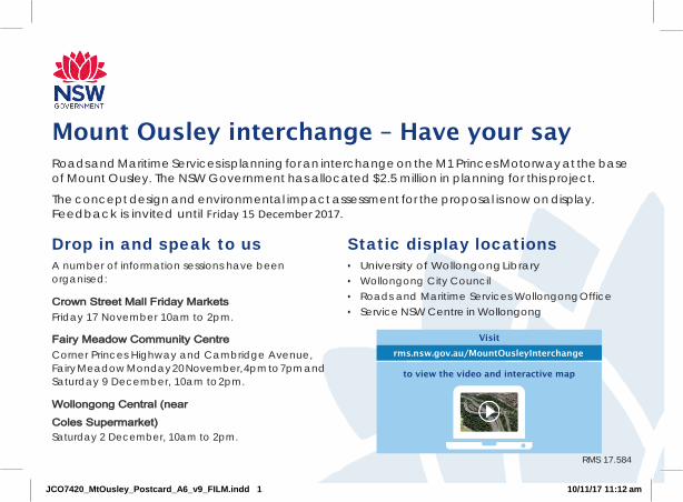
Mount Ousley interchange – Have your say Roads and Maritime Services is planning for an interchange on the M1 Princes Motorway at the base of Mount Ousley. The NSW Government has allocated $2.5 million in planning for this project.
The concept design and environmental impact assessment for the proposal is now on display. Feedback is invited until Friday 15 December 2017.
Drop in and speak to us A number of information sessions have been organised:
Crown Street Mall Friday Markets Friday 17 November 10am to 2pm.
Fairy Meadow Community Centre Corner Princes Highway and Cambridge Avenue, Fairy Meadow Monday 20 November, 4pm to 7pm and Saturday 9 December, 10am to 2pm.
Wollongong Central (near Coles Supermarket) Saturday 2 December, 10am to 2pm.
Static display locations • University of Wollongong Library• Wollongong City Council• Roads and Maritime Services Wollongong Office• Service NSW Centre in Wollongong
RMS 17.584
JCO7420_MtOusley_Postcard_A6_v9_FILM.indd 1 10/11/17 11:12 am
Visit
to view the video and interactive map
rms.nsw.gov.au/MountOusleyInterchange

for people, business and freight
Better and more
Improving trafic flow
Improving
safety
Easing congestion
Improve pedestrian safety
JCO7420_MtOusley_Postcard_A6_v9_FILM.indd 2 10/11/17 11:12 am
reliable trips
Have your say Feedback is invited by Friday 15 December 2017.
To find out more or provide feedback:
rms.nsw.gov.au/MountOusleyInterchange
1800 792 918
Mount Ousley Interchange Roads and Maritime Services PO Box 477, Wollongong NSW 2520

Appendix B
Respondents

Respondent Submission number Section of report where issues are addressed
Community member 1 2.8.1
Community member 2 2.3.1, 2.3.4, 2.3.8
Community member 3 2.2.1
Community member 4 2.3.1, 2.3.4, 2.3.5, 2.3.8, 2.8.1
Community member 5 2.2.1, 2.4.2
Community member 6 Submission in support. No specific section.
Community member 7 2.2.1, 2.4.2
Private corporation 8 Submission in support. No specific section.
Community member 9 2.2.1, 2.6
Community member 10 2.2.1, 2.8.2
Community member 11 Submission in support. No specific section.
Community member 12 2.2.1, 2.3.5, 2.3.6
Community member 13 Submission in support. No specific section.
Community member 14 Submission in support. No specific section.
Community member 15 2.6
Community member 16 2.3.9
Community member 17 Submission in support. No specific section.
Community member 18 2.4.2
Community member 19 2.3.1
Community member 20 2.3.11
Community member 21 2.4.3
Community member 22 2.4.3
Community member 23 Submission in support. No specific section.
Community member 24 2.2.1

Respondent Submission number Section of report where issues are addressed
Community member 25 2.3.1, 2.3.2, 2.5.1, 2.5.2
Community member 26 2.3.11, 2.4.3
Community member 27 2.4.2
Community member 28 2.3.3, 2.4.3, 2.3.12
Community member 29 2.2.1
Community member 30 Submission in support. No specific section.
Community member 31 Submission in support. No specific section.
Community member 32 Submission in support. No specific section.
Community member 33 Submission in support. No specific section.
Community member 34 2.2.1, 2.4.3
Community member 35 Submission in support. No specific section.
Community member 36 2.2.2
Schools / Education 37 2.2.1, 2.3.5, 2.3.6, 2.3.7, 2.3.12, 2.3.13, 2.4.2, 2.5.1, 2.8.1
Community member 38 2.3.4
Community member 39 2.3.1, 2.3.8
Community member 40 2.2.1, 2.2.2, 2.3.1, 2.7
Community member 41 2.3.12
Community member 42 2.7
Community member 43 2.8.1
Community member 44 2.3.1, 2.3.5, 2.3.8, 2.3.7, 2.4.2
Community member 45 2.3.7
Community member 46 2.3.1
Community member 47 2.3.2, 2.3.6
Community member 48 2.3.5
Community member 49 2.4.3
Community member 50 2.3.7, 2.5.1

Respondent Submission number Section of report where issues are addressed
Community member 51 2.2.1, 2.4.2
Community member 52 2.2.1, 2.7
Community member 53 2.3.6
Community member 54 2.3.8
Community member 55 2.3.11, 2.4.2
Community member 56 2.2.1, 2.3.2, 2.4.2, 2.4.3, 2.8.1
Community member 57 2.2.1, 2.5.3
Community member 58 Submission in support. No specific section.
Community member 59 2.2.1, 2.3.4, 2.3.7
Community member 60 2.3.4, 2.4.3
Community member 61 2.3.8, 2.3.10
Community member 62 2.4.3
Community member 63 2.4.2
Community member 64 2.2.1, 2.3.3
Community member 65 2.3.5
Community member 66 2.3.1, 2.3.10, 2.4.3
Community member 67 2.3.1
Community member 68 General submission. No specific matters raised.
Community member 69 2.2.1, 2.3.4, 2.3.6, 2.4.2
Community member 70 2.2.1, 2.3.5
Community member 71 2.3.1
Community member 72 2.3.7, 2.3.8, 2.4.2, 2.4.2
Community member 73 2.3.10
Community member 74 2.3.10
Community member 75 2.3.1, 2.3.4
Community member 76 2.3.3, 2.3.7, 2.3.10, 2.4.2

Respondent Submission number Section of report where issues are addressed
Community member 77 2.3.1
Community member 78 2.3.1, 2.3.3, 2.3.4, 2.3.10
Community member 79 2.4.2, 2.4.3, 2.3.6, 2.3.8
Community member 80 2.3.5
Community member 81 2.3.1
Community member 82 2.4.2
Community member 83 2.5.1
Community member 84 2.2.1, 2.3.6
Community member 85 2.3.8
Community member 86 2.3.1, 2.3.2, 2.3.4, 2.4.4, 2.8.1
Community member 87 2.3.3
Community member 88 2.3.6, 2.3.8
Community member 89 Submission in support. No specific section.
Community member 90 Submission in support. No specific section.
Community member 91 2.3.3
Community member 92 2.3.10
Community member 93 Submission in support. No specific section.
Community member 94 2.4.2
Community member 95 2.3.7
Community member 96 2.2.1
Community member 97 Submission in support. No specific section.
Community member 98 2.3.4, 2.8.1
Community member 99 2.4.1
Community member 100 2.2.1
Community member 101 2.4.2
Community member 102 2.3.1, 2.4.3

Respondent Submission number Section of report where issues are addressed
Community member 103 2.2.1, 2.3.3, 2.3.8
Community member 104 2.3.6
Community member 105 Submission in support. No specific section.
Community member 106 2.3.5
Community member 107 2.3.5
Community member 108 2.3.1, 2.3.10, 2.5.1, 2.5.2
Community member 109 2.8.2
Community member 110 2.2.1, 2.8.2
Community member 111 2.8.2
Community member 112 2.8.2
Community member 113 2.2.1, 2.8.2
Community member 114 2.2.1, 2.8.2
Community member 115 2.8.2
Community member 116 2.2.1, 2.8.2
Community member 117 2.2.1, 2.8.2
Community member 118 2.2.1, 2.8.2
Community member 119 2.2.1, 2.8.2
Community member 120 2.2.2
Community member 121 2.2.1, 2.8.2
Community member 122 2.2.1
Community member 123 2.2.1, 2.8.2
Community member 124 2.2.1
Community member 125 2.8.2
Community member 126 2.2.1, 2.8.2
Community member 127 2.2.1, 2.8.2
Community member 128 2.2.1, 2.8.2

Respondent Submission number Section of report where issues are addressed
Community member 129 2.2.1, 2.8.2
Community interest group 130 Submission in support. No specific section.

rms.nsw.gov.au/MountOusleyInterchange
1800 792 918
Customer feedbackRoads and MaritimePO BOX 477Wollongong NSW 2520
Pub no: RMS.18.773 ISBN: 978-1-925797-09-1


![Smart motorway design guide - Roads and Maritime Services · 2017-04-21 · Smart [1]Motorway Technical Direction and the Smart Motorway Guidelines[2]. 1.2 Smart motorway document](https://img.pdfslide.us/doc/110x75/5e764c607cf5f006800a1c9a/smart-motorway-design-guide-roads-and-maritime-services-2017-04-21-smart-1motorway.jpg)