Embed Size (px)
Citation preview

Highly detailed aerial imagery for project sites is now an affordable option, thanks to advancements in unmanned aircraft systems (UAS) technology and digital photogrammetry. These technological advancements allow for the creation of centimeter pixel resolution imagery with much greater detail than that found in satellite imagery and traditional aerial imagery. In fact, UAS orthoimagery can contain over 10,000 pixels within the space of a single satellite imagery pixel. That means through UAS orthoimagery, actual ground conditions are visible to the naked eye—we can now see things that were not previously distinguishable in satellite imagery.
The USGS definition states: “Orthoimagery data typically are high resolution aerial images that combine the visual attributes of an aerial photograph with the spatial accuracy and reliability of a planimetric map”.
Through orthorectification of UAS aerial imagery a constant scale is generated, where features are displayed in their “true”, or planimetrically correct position. The UAS orthoimage can then be georeferenced to survey data on the ground, resulting in an accurate dataset.
Regulations governing the use of UAS
Commercial operation of small UAS is now regulated by the Federal Aviation Administration (FAA), under Title 14 of CFR, part 107. Brice’s UAS operators carry the necessary FAA remote airmen endorsement, and are familiar with part 107 regulations. Many UAS flight restrictions still exist, but waivers may be obtained as needed.
Saint George Harbor Breakwater Repair, Alaska. This highly complex project involved using mechanical equipment to place over 10,200 cubic yards of 6-12 ton Armor rock on a breakwater.
` Estimated armor rock quantities daily, ensured construction aligned with engineering model
` Assisted stakeholders with decision-making through high resolution imagery when site visits were not possible due to the remote location
` Reduced safety hazard and risk of putting individuals in a dangerous environment when site conditions were not amenable for traditional surveying due to 10-20 foot waves
Alaska Army National Guard, Federal Scout Readiness Center Remedial Investigation, Emmonak, Alaska. Emmonak lies 120 air miles northwest of Bethel and 490 air miles from Anchorage in the remote Yukon Delta National Wildlife Refuge.
` Provided highly accurate and detailed imagery of site for reporting and capturing current site conditions and features not visible in satellite imagery
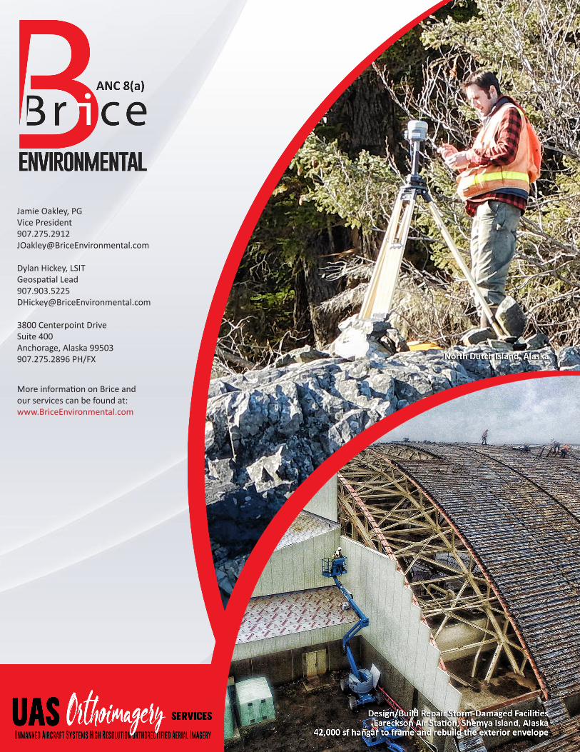
Federal Aviation Administration, North Dutch Island VHF Station Release Investigation and Interim Removal Action, Prince William Sound, Alaska. Removed and disposed of approximately 300 cubic yards of petroleum contaminated soil at North Dutch Island located within the Chugach National Forest, 32 miles east of Whittier in Prince William Sound and northeast of Perry Island.
` Provided very accurate basemap that aligned seamlessly with survey data
` Captured site conditions after demolition and remediation detailing the work completed
Federal Aviation Administration, Infrastructure Removal and Release Investigation, Chirikof Island, Alaska. The project was performed at a site requiring complex mobilization and demobilization logistics by barge only.
` Generated highly detailed topographic and accurate site basemaps capturing features not visible in available satellite or traditional higher-altitude aerial imagery
` Employed surface modeling to estimate soil and debris quantities for removal
Federal Aviation Administration, Bench-Scale Pilot Study and Feasibility Study, Puntilla Lake, Alaska. This is a pilot study of in-situ chemical oxidation at one site and an evaluation of phase-separated product recovery at another site in a remote location with very limited logistical support.
` Generated highly detailed topographic and site basemaps that captured features not visible in available satellite or traditional higher-altitude aerial imagery
` Documented the precise location and detail of a small excavation
Air Force Civil Engineering Center, Wake Island Air Field Repair Water Distribution System,Wake Island Atoll. Wake is one of the most isolated islands in the world, and is primarily used as a mid-Pacific refueling stop and emergency landing area.
` Processed imagery aligned precisely with available as-built maps that enriched the as-built with additional detail and information
High Resolution Aerial Mapping
` Centimeter resolution orthorectified aerial imagery
` High accuracy georeferencing
` Surface modeling and topographic measurements
` Material quantity estimating
Site Documentation
` Oblique photography ` High definition video ` Change detection and site
monitoring ` Remote infrastructure
inspection
FAA Remote Pilot Endorsement
` Multiple pilot endorsements ` Approximately 100 flight
hours with no reportable incidents
While small excavations, fuel storage tanks, pipelines and other key site features may be indistinguishable via satellite imagery UAS technology makes them easily visible.
Why you should incorporate UAS aerial imagery
UAS orthoimagery can add tremendous value for project scoping, planning, and execution, as well as ongoing site monitoring, especially at small remote sites for which very poor historical aerial and satellite imagery currently exists, if at all. With UAS orthoimagery, we can now document site conditions before, during and after fieldwork at minimal cost. Further, orthorectification and georeferencing give you confidence that the image coordinates of a site feature are a true representation of its ground location. Lastly, image processing turnaround time is minimal, allowing you to use the imagery in near real time to track progress and make decisions on a more timely basis.
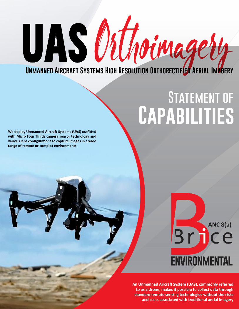
UAS ServicesBrice self-performs UAS orthoimagery with minimal additional project costs. We utilize a large-format, Micro Four Thirds (MFT) 16-megapixel camera on our UAS to capture imagery. Different lenses can be outfitted on the camera, to apply the focal length most suitable to site conditions.
` Orthorectified aerial imagery ` 4k high-definition video and oblique
imagery ` Thermal Infrared imaging and mapping ` Remote inspection of civil infrastructure,
such as towers and bridges ` Digital terrain modeling and volume
estimating ` Project site monitoring
Brice Environmental Services Corporation | Statement of Capabilities Unmanned Aircraft Systems High Resolution Orthorectified Aerial Imagery (UAS Orthoimagery)
Jamie Oakley, PGVice [email protected]
Dylan Hickey, LSITGeospatial [email protected]
3800 Centerpoint DriveSuite 400Anchorage, Alaska 99503907.275.2896 PH/FX
More information on Brice andour services can be found at:www.BriceEnvironmental.com