Embed Size (px)
Citation preview

Lyons Canyon Ranch Draft Environmental Impact Report
September 2006 5.7-1 Cultural Resources
5.7 CULTURAL RESOURCES This section of the EIR evaluates the impacts of the proposed project on historical, archaeological, and paleontological resources. The analysis provided below is based on the proposed project’s Cultural Resources Assessment, performed by BonTerra Consulting (November 2004), which is contained in its entirety in Appendix J. 5.7.1 ENVIRONMENTAL SETTING
BonTerra Consulting conducted a Phase I cultural resources assessment for the proposed project. The overall project site is presently undeveloped but portions have been used previously for ranching or farming, and as a filming locale for television and films. The proposed project is subject to the California Environmental Quality Act (CEQA) Guidelines. Impacts to drainages in the project area will require a Section 404 nationwide permit under the Clean Water Act (CWA) of 1977, which authorizes the U.S. Army Corps of Engineers (ACOE) to issue permits regulating impacts to waters and wetlands of the United States. To issue a Section 404 permit, the ACOE must comply with Section 106 of the National Historic Preservation Act (NHPA) of 1966, as amended, which requires federal agencies to consider the potential of a project to adversely affect cultural resources. In compliance with CEQA and Section 106, therefore, this study was conducted to identify whether any cultural (archaeological or historic) or paleontological (faunal or floral fossil) resources might be adversely affected by the proposed project. LOCATION AND SETTING The project site is located in the unincorporated Stevenson Ranch area near Santa Clarita in northwestern Los Angeles County. The specific location is best described as the northern half of Section 9, southeast quarter of the southwest quarter of Section 4, and southwest quarter of the southeast quarter of Section 4 in Township 3 North, Range 16 West (San Bernardino Base and Meridian), excluding minor portions along the eastern side of this area reduced by the Interstate 5 freeway corridor and The Old Road. The project site appears on the U.S. Geological Survey (USGS) Oat Mountain 7.5’ Quadrangle. The 97-acres within the impact “footprint” include lowland areas as well as hills and ridgelines (refer to Exhibit 5.7-1, Cultural Resource Survey Boundary and Impact Areas). The project site is characterized by hilly topography on either side of the site’s central feature, the east-west trending Lyon Canyon drainage. This and an unnamed drainage just to the north have relatively flat bottoms, while others in the project site are V-shaped, cut by the erosion of steep slopes and sharp ridgelines.

Lyons Canyon Ranch Draft Environmental Impact Report
September 2006 5.7-2 Cultural Resources

Lyons Canyon Ranch Draft Environmental Impact Report
September 2006 5.7-3 Cultural Resources
Elevations in the project site range from about 1,654 feet above mean sea level (msl) at the southwest corner to about 1,300 feet at the northeast corner. Lyon Canyon drains eastward into the South Fork of the Santa Clara River, which leads to the Santa Clara River (proper) 3.75 miles northeast of the project site. Following a wide, flat valley to the Pacific Ocean, the Santa Clara River is chiefly a shallow, multi-channel or “braided” streambed of sand and silt that has been utilized for quarry material and as productive farmland. The Santa Clarita area is situated in the northern Transverse Ranges between the westernmost reaches of the San Gabriel Mountains to the east and Santa Susana Mountains to the west. Geologically, bedrock in this area is composed primarily of the Saugus Formation (non-marine). Within the project site, the Pico Formation (marine) also occurs. Both formations contain fossil materials. Alluvial lowlands in the project site have been disturbed, and vegetation is now dominated by intrusive species such as Slender Wild Oats (Avena barbata), brome grasses (Bromus sp.), pigweed (Amaranthus albus), mustards (Brassica nigra, Hirschfeldia incana), and filarees (Erodium spp.). Canyons burned in recent wildfires exhibit recovering chaparral growth, with Coast Live Oak (Quercus agrifolia var. agrifolia) and a few Valley Oak (Quercus lobata) surviving along the base of slopes. CULTURAL BACKGROUND Prehistoric Background The project’s Cultural Resources Assessment includes a detailed discussion of the history of the Santa Clarita area as relates to cultural resources. However, the most relevant discussion pertains to the most recent Native American residents of the Santa Clarita Valley, the Tataviam. The greatest potential for archaeological resources in the area, including burial sites, would be related to Tataviam settlements in the Valley. The Tataviam were hunter-gatherers that spoke a variant of the indigenous Takic language. Takic-speakers are believed to have migrated into southern California from the Great Basin sometime between 1,000 and 3,000 years ago, an event some archaeologists believe interrupted the long-standing Millingstone way of life. Tataviam subsistence centered upon the seasonal gathering of plant foods (yucca, acorns, sage seeds, and juniper berries) and hunting (rabbit, rodents, deer, and antelope). Acorns, the staple food of most Late Period groups in California, may have been less important to the Tataviam, who utilized yucca more extensively. The plant was roasted in stone-lined earth ovens, often identified archaeologically. With the Santa Clara River Valley and Antelope Valley acting as east-west corridors between the deserts and coast, the Tataviam likely participated in “down the line” long-distance trade. Shell beads found in the western Mojave Desert, for example were acquired by the Takic-speaking Kitanemuk through a trade network in which the Tataviam may have been linked with Hokan-speaking Chumash on the coast. Although the Tataviam and Chumash differed linguistically, some aspects of their material culture, such as ritual objects and pictographs, were quite similar.
Lyons Canyon Ranch Draft Environmental Impact Report
September 2006 5.7-4 Cultural Resources
A number of Tataviam villages have been identified through historic registers at Mission San Fernando, including tsawayung at the original Mexican-era Rancho San Francisco headquarters near Castaic Junction, akure’eng near the spring at the Newhall townsite, and tochonanga southeast of the Newhall townsite. Historic Background Historical accounts of development of the Santa Clarita Valley are most substantial following the California gold rush, during which time ranching and agriculture gave way to railroad development and oil speculation. During the winter of 1861-1862, relentless rains in southern California produced catastrophic floods that washed away buildings, crops, and livestock by the thousands. The floods were followed by two years of catastrophic drought that dealt another crippling blow to crops and livestock. Land values fell dramatically, and most ranchers were forced to sell their holdings. The crisis opened the door to speculators and entrepreneurs from the East Coast who envisioned profitable new developments on cheap land. One of these was Thomas A. Scott of the Pennsylvania Railroad. Scott sent Thomas Bard to California to purchase land in the quest for oil, and Bard purchased Rancho San Francisco in 1865. The enterprise was unsuccessful, and Bard sold Rancho San Francisco to rancher Henry Mayo Newhall in 1875. Oil speculation in the region, however, continued at a brisk pace as discoveries were made in other locations. On 6 September 1876, the Southern Pacific Railroad was completed through Soledad Canyon and crossed Newhall’s Rancho San Francisco along the upper Santa Clara River. The golden spike driven at Lang Station represented a critical link between Los Angeles, northern California, and transcontinental routes to the east. The site of Lang Station is designated California Historical Landmark No. 590. A station aptly named Newhall was established on 28 October 1876, but was renamed Saugus two years later when the original name was transferred to a new station constructed two miles to the south. The earliest attempts to commercialize oil in southern California occurred during the 1850s. The region was already well known to Native Americans and early explorers for tar seeps and petroleum springs, but the first saleable petroleum-based products were lamp fuels such as camphene and kerosene (made to replace the more expensive alternative, whale oil), and lubricants. Crude petroleum for these products was skimmed or dipped from pools on the surface or in pits or shafts. According to Hutchinson, the first “true” oil well in southern California was drilled in 1865 near Piru. Oil speculation in Rancho San Francisco had commenced under Thomas Bard in 1865. However, Henry Mayo Newhall, who had acquired the ranch from Bard ten years later, was not interested in the oil business and concentrated instead on traditional ranching pursuits – raising cattle, sheep, and horses – and agricultural endeavors, such as growing wheat and fruit trees and improving irrigation. Even so, he allowed speculation by “wildcatters” to continue. In 1875, Well No. 4 in Pico Canyon struck oil, becoming the state’s first successful well and establishing the Newhall Field. “Pico No. 4" is designated California Historical Landmark No. 516. All

Lyons Canyon Ranch Draft Environmental Impact Report
September 2006 5.7-5 Cultural Resources
other speculation efforts on the ranch failed, however, and as late as 1934 Newhall’s son William declared that, “there is no indication that this ranch is an oil property.” It wasn’t until 1936 – more than 60 years after the strike at Pico No. 4 – that oil was struck on the ranch again, in Potrero Canyon. By 1940, however, most pools in the Greater Newhall Field had been exhausted, and the majority of operations in the Newhall area were shut down. The Castaic Junction and Honor Rancho fields were discovered in 1950, but did not produce substantial yields. In 1914, construction began on a more direct roadway over the Liebre Mountains between the Newhall-Saugus area and Gorman. Originally a graded dirt surface called the Tejon Route, the road was opened to vehicles in 1915. The roadway was finished with concrete in 1919 and eventually became known as the Ridge Route. To better handle the increasing volume of traffic, the more streamlined Highway 99 was constructed in 1933, now superceded by the modern Interstate 5 freeway. METHODOLOGY Cultural Resources Records Search A cultural resources records search for the Lyons Canyon Ranch project was conducted by staff of the South Central Coastal Information Center (SCCIC) at California State University, Fullerton on 14 October 2004. The SCCIC is the designated branch of the California Historical Resources Information System (CHRIS) maintaining records on archaeological and built-environment resources located in Los Angeles County. The records search provided information on all cultural resources and previous studies that have been recorded within one mile of the project site. The SCCIC reviewed archaeological records, Archaeological Determinations of Eligibility (DOE) listings, historic maps, the California Historic Resources Inventory (HRI) for Santa Clarita and vicinity, and the City of Los Angeles inventory of Historic-Cultural Monuments. The HRI contains listings for the National Register of Historic Places (NRHP), California Register of Historic Resources (CRHR), State Historical Landmarks (SHL), and California Points of Historical Interest (PHI). Section 106 Consultation In compliance with Section 106 of the NHPA, the resource identification effort included consultation with the Native American Heritage Commission (NAHC) in Sacramento regarding the possibility of special Native American sites in the project vicinity. On 13 October 2004, the NAHC reviewed the sacred lands file and prepared a list of local representatives who could be contacted in regard to the project. On 15 October 2004, a Native American representative directly associated with the Santa Clarita area was contacted in regards to the proposed project.

Lyons Canyon Ranch Draft Environmental Impact Report
September 2006 5.7-6 Cultural Resources
Also in compliance with Section 106, the identification effort included consultation with local historical groups regarding the possibility of non-Native American historic-era sites or resources in the vicinity of the project that might not be identified in state or county inventories. The following agencies were also contacted:
♦ Historical Society of Southern California, Los Angeles ♦ San Fernando Valley Historical Society, Mission Hills ♦ Santa Clarita Valley Historical Society, Newhall ♦ William S. Hart County Park and Museum, Newhall
Archaeological Field Survey A systematic archaeological field survey of the project site was conducted by Richard Shepard, M.A. of BonTerra Consulting on 11 and 13 October and 3 November 2004. Mr. Shepard is a Registered Professional Archaeologist (RPA) qualified under CEQA and Secretary of the Interior Standards. The project site was walked in parallel transects averaging 15 meters in width and oriented east-west in flat areas near the mouth of Lyon Canyon and north-south in the canyon’s narrow upper reaches. Ridgelines exhibiting a possibility of retaining archaeological materials were walked according to their axes. Steep slopes were not surveyed because gravity and erosion prevent retention of archaeological materials on such landforms. Ground visibility ranged from good (on ridgelines) to poor (in canyon bottoms) because of variable vegetation. A Magellan Meridian Global Positioning System (GPS) unit was carried to accurately map any resources encountered, and a Canon EOS 2000 35-millimeter camera was used for general-purpose photographs. PALEONTOLOGICAL RESOURCES Records Search and Literature Review To meet additional requirements under CEQA in the general category of Cultural Resources, a paleontological resources records search and literature review for the project site was conducted by Samuel McLeod, Ph.D., a qualified paleontologist in the Vertebrate Paleontology Section of the Natural History Museum of Los Angeles County (NHMLAC) on October 5, 2004. The NHMLAC is the designated repository for records concerning fossil resources and localities in Los Angeles County. The records search and literature review provided data on fossil types and localities recorded within a wide radius of the project.

Lyons Canyon Ranch Draft Environmental Impact Report
September 2006 5.7-7 Cultural Resources
RESULTS OF THE CULTURAL RESOURCES ASSESSMENT Cultural Resources Records Search Results Previous Research The SCCIC reported that at least 16 previous studies have been conducted within one mile of the project site. Six of these consisted of archaeological surveys that covered various portions of the project site, summarized in Table 5.7-1, Previous Surveys Within the Project Site.
Table 5.7-1 Previous Surveys Within the Project Site
SCCIC Report No. Author(s) and Year Total Coverage, Relative Portion of the Current Project
Site, and Resources Identified
LA-23 Nelson (no date) 175 acres (approx.), northernmost edge of the project site, no resources
LA-103 Singer 1975 50 acres (approx.), southeast corner of the project site, no resources
LA-1062 Schliz 1981 470 acres, western and northern areas of the project site, no resources
LA-2950 Peak and Associates 1992 172 acres, eastern edge of the project site, no resources (in the vicinity of the project site)
LA-3000 Simon and Whitley 1993 225 acres, western and northern areas of the project site, unspecified resources
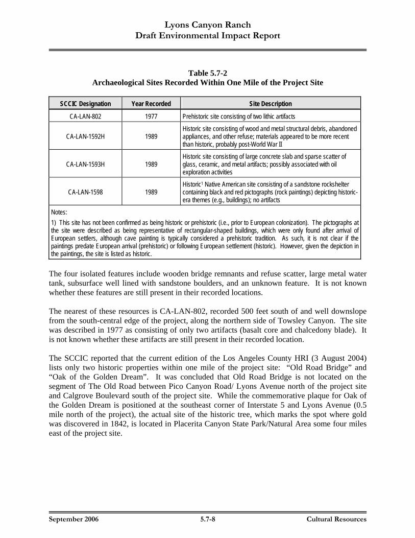
LA-5533 Smith 2000 1 linear mile, eastern side of the project site, no resources The data in Table 5.7-1 show that even though various portions of the project site were examined by a number of previous surveys, no resources were identified within the Lyons Canyon Ranch project area. Based on these results, one would predict that few or no resources would be identified in unsurveyed areas of the project site as a result of this investigation. PREVIOUSLY RECORDED RESOURCES The SCCIC reported that four archaeological sites and four isolated features have been recorded within one mile of the project site, all within Towsley Canyon south of the project site. The four archaeological sites are summarized below in Table 5.7-2, Archaeological Sites Recorded Within One Mile of the Project Site.
Lyons Canyon Ranch Draft Environmental Impact Report
September 2006 5.7-8 Cultural Resources
Table 5.7-2 Archaeological Sites Recorded Within One Mile of the Project Site
SCCIC Designation Year Recorded Site Description
CA-LAN-802 1977 Prehistoric site consisting of two lithic artifacts
CA-LAN-1592H 1989 Historic site consisting of wood and metal structural debris, abandoned appliances, and other refuse; materials appeared to be more recent than historic, probably post-World War II
CA-LAN-1593H 1989 Historic site consisting of large concrete slab and sparse scatter of glass, ceramic, and metal artifacts; possibly associated with oil exploration activities
CA-LAN-1598 1989 Historic1 Native American site consisting of a sandstone rockshelter containing black and red pictographs (rock paintings) depicting historic-era themes (e.g., buildings); no artifacts
Notes: 1) This site has not been confirmed as being historic or prehistoric (i.e., prior to European colonization). The pictographs at the site were described as being representative of rectangular-shaped buildings, which were only found after arrival of European settlers, although cave painting is typically considered a prehistoric tradition. As such, it is not clear if the paintings predate European arrival (prehistoric) or following European settlement (historic). However, given the depiction in the paintings, the site is listed as historic.
The four isolated features include wooden bridge remnants and refuse scatter, large metal water tank, subsurface well lined with sandstone boulders, and an unknown feature. It is not known whether these features are still present in their recorded locations. The nearest of these resources is CA-LAN-802, recorded 500 feet south of and well downslope from the south-central edge of the project, along the northern side of Towsley Canyon. The site was described in 1977 as consisting of only two artifacts (basalt core and chalcedony blade). It is not known whether these artifacts are still present in their recorded location. The SCCIC reported that the current edition of the Los Angeles County HRI (3 August 2004) lists only two historic properties within one mile of the project site: “Old Road Bridge” and “Oak of the Golden Dream”. It was concluded that Old Road Bridge is not located on the segment of The Old Road between Pico Canyon Road/ Lyons Avenue north of the project site and Calgrove Boulevard south of the project site. While the commemorative plaque for Oak of the Golden Dream is positioned at the southeast corner of Interstate 5 and Lyons Avenue (0.5 mile north of the project), the actual site of the historic tree, which marks the spot where gold was discovered in 1842, is located in Placerita Canyon State Park/Natural Area some four miles east of the project site.

Lyons Canyon Ranch Draft Environmental Impact Report
September 2006 5.7-9 Cultural Resources
ARCHIVAL MAPS The following archival maps in which the project area appears were reviewed by the SCCIC and/or BonTerra Consulting for evidence of early development within the site:
♦ 1903 USGS Camulos 30' Quadrangle, surveyed 1893 and 1900-1901 ♦ 1903 USGS Santa Susana 15' Quadrangle, surveyed 1900 ♦ [no date] USGS Newhall 6' Quadrangle, surveyed 1925-1929 (pre-1933 advance sheet) ♦ 1933 USGS Newhall 6' Quadrangle, surveyed 1925-1929 ♦ 1941 USGS Santa Susana 15' Quadrangle, aerial photos 1940-1941 ♦ 1952 USGS Oat Mountain 7.5' Quadrangle, aerial photography 1947 ♦ 1969 USGS Oat Mountain 7.5' Quadrangle, revision of 1952 edition (aerial photos 1969)
The 1903 quadrangles show no circa 1900 development (structures, roads, wells, or other cultural features) within the project site. No roads are shown in or adjacent to the project site, or are there any indications of 19th century oil speculation by Sanford Lyon. The 1933 quadrangle (based on surveys in 1925-1929) shows three structures and a drainage feature within the project site. These include a structure near the confluence of the two main drainages in the project site (SE ¼ of SE ¼ of SE ¼ of SE ¼ of Section 4), two structures roughly 1,400 feet south of that point (SE ¼ NE ¼ of NW ¼ of Section 9), and a small check dam roughly 1,250 feet northwest of the second point (NW ¼ of NE ¼ of NW ¼ of NW ¼ of Section 9), all linked by an unimproved road through Lyon Canyon. U.S. Highway 99, constructed in 1930, is shown as a single-width roadway passing by the eastern side of the project site. The highway is not paralleled in this location by a secondary road where The Old Road is today. The 1941 quadrangle (based on aerial photos taken in 1940-1941) shows the unimproved road within the project site as indicated by the previous quadrangle, but the circa 1925-1929 structures no longer appear. Two different structures are shown next to the western edge of U.S. Highway 99 (single-width roadway) along the eastern periphery of the project site. No secondary road appears next to the highway where The Old Road is today. The 1952 quadrangle (based on aerial photos taken in 1947) shows that the two structures along the eastern periphery of the project site had been removed, probably as a result of improvements to U.S. Highway 99, which had by this time been widened to a divided roadway. Other structures are shown in the approximate locations of those depicted in the 1933 quadrangle, as well as a structure on a hillside near the northeast corner of the project site. Again, no secondary road appears next to the highway where The Old Road is today. The Old Road does not appear in its current alignment next to the project site until revisions to the quadrangle were made in 1969. Several additional structures had appeared within the project site by that time. SECTION 106 CONSULTATION RESULTS

Lyons Canyon Ranch Draft Environmental Impact Report
September 2006 5.7-10 Cultural Resources
The NAHC reported that the sacred lands file did not indicate any special Native American sites or resources in the vicinity of the project site. Local Native American representative John Valenzuela stated that he has general concerns about this and other projects in the Santa Clarita-Canyon Country area, but did not identify any specific sites or resource locations nor indicate that the project would affect any such locations. No responses were received from any of the local historical groups contacted in regard to the possibility of locally important or unrecorded historic-era sites in the project vicinity. FIELD SURVEY RESULTS No archaeological sites or potentially significant resources were identified within the project site during the field survey. No standing buildings are present in the project site. No evidence of prehistoric or historic-era archaeological deposits was observed. Although the check dam shown in the 1933 quadrangle remains in place, no evidence of any early buildings could be identified. The only visible structure-related remains consist of the following:
♦ Generic concrete slabs, small concrete shed, asphalt road surfaces, wire fencing, and power poles (charred by recent wildfires) in the area near the confluence of the two main drainages (SE ¼ of SE ¼ of SE ¼ of Section 4);
♦ Generic wire fencing, livestock watering trough, and power poles (charred by recent
wildfires) in the area south of the first location (SE ¼ of NE ¼ of NW ¼ of Section 9);
♦ Check dam constructed of poured concrete with square steel “re-bar” and a steel outlet valve embossed with WALWORTH, situated in a small V-shaped side canyon (NE ¼ of NW ¼ of NW ¼ of Section 9); and
♦ Graded, asphalt-covered pad and small diameter water pipe in the location of a structure
shown by the 1952 quadrangle on a hillside near the northeast corner of the project site (SE ¼ of NW ¼ of SW ¼ of SE ¼ of Section 4) – probably a pump shed or water tank.
The only observed evidence of early activity in the project site consists of the concrete check dam, which dates to the 1920s according to USGS quadrangles. Lengths of exposed “re-bar” across the top edge indicate that an additional upper portion or tier was present but is now missing. The cavity behind the dam is heavily silted in. The check dam is generic in design and materials and as an incomplete isolated feature is not a potentially significant resource. The Old Road along the eastern side of the project site, by virtue of its name, is suggestive of a historic-era feature, but USGS quadrangles show that it did not exist in its present alignment until after World War II and perhaps not until the 1960s. The name appears to memorialize a road that was built through Weldon Canyon/Gavin Canyon during 1929 as an alternative to “the old road” (San Fernando Road, at the time the main link between Los Angeles, Newhall, and areas to the north). The alternate route was needed because a narrow tunnel on San Fernando

Lyons Canyon Ranch Draft Environmental Impact Report
September 2006 5.7-11 Cultural Resources
Road south of Newhall caused bottleneck traffic congestion. The Weldon Canyon cut-off road, as it was known, was only 20 feet wide and was erased, as indicated by USGS quadrangles, when overlain in 1933 by U.S. Highway 99 (known as the Ridge Alternate because it provided a streamlined alternative to the original Ridge Route of 1915). By 1972, U.S. Highway 99 itself had been overlain in this area by Interstate 5, the Golden State Freeway. Thus, The Old Road adjacent to the project site is a relatively recent feature. PALEONTOLOGICAL RESOURCES Records Search and Literature Review Results According to the NHMLAC, flatlands and canyon floors within the project site are composed primarily of relatively recent alluvium, and these areas, therefore, are not likely to contain significant fossil resources. However, uplifted slopes, ridges, and associated bedrock within the project site are composed of either the non-marine Saugus Formation (roughly the northeastern two-thirds of the project site) or slightly older marine Pico Formation (roughly the southwestern one-third of the project site). Both formations originated during the Pliocene epoch some five million years ago, and both have been known to contain significant vertebrate fossil remains at other nearby sites. The NHMLAC reported that two fossil localities, LACM 6145 and 6146, occur near the southeastern corner of the project site. These localities produced fossilized shark and fish characteristic of the marine Pico Formation, including Bull Shark (Carcharhinus), Basking Shark (Cetorhinus), Guitarfish (Rhinobatos), Sheepshead (Semicossyphus), and Eagle Ray (Myliobatis). Other fossil localities from the Pico and Saugus Formations are also recorded in the general area and are summarized in Table 5.7-3, Fossil Localities Recorded in the Vicinity of the Project Site.
Table 5.7-3 Fossil Localities Recorded in the Vicinity of the Project Site
NHMLAC
Designation General Area of
Discovery Geologic Formation and Description of Fossil(s)
LACM 1931 Santa Susana area Pico Formation: rare Right Whale, Balaenidae
LACM 5456 Brown’s Canyon Pico Formation: Bonito Shark, Isurus planus, White Shark, Carcharocles
LACM 6145 Project site Pico Formation: Bull Shark, Carcharhinus, Basking Shark Cetorhinus, Guitarfish Rhinobatos, Sheepshead Semicossyphus, Eagle Ray, Myliobatis
LACM 6146 Project site Pico Formation: Bull Shark, Carcharhinus, Basking Shark Cetorhinus, Guitarfish Rhinobatos, Sheepshead Semicossyphus, Eagle Ray, Myliobatis
LACM 6601 San Fernando area Saugus Formation: deer and rare tapir, Tapirus merriami (scientific paper)
LACM 6803 Saugus area Saugus Formation: dog, Canidae, horse, Equus, camel, Camelidae
LACM 6804 Saugus area Saugus Formation: dog, Canidae, horse, Equus, camel, Camelidae

Lyons Canyon Ranch Draft Environmental Impact Report
September 2006 5.7-12 Cultural Resources
LACM 6871 Saugus area Saugus Formation: dog, Canidae, horse, Equus, camel, Camelidae The NHMLAC concluded that excavations within the project site in areas other than canyon floors, where relatively recent alluvium predominates, are likely to encounter significant vertebrate fossil resources. DMEC has observed and mapped marine fossil beds onsite. Exhibit 5.7-2, Fossil Beds at Lyons Canyon Ranch, illustrates three specific locations where marine fossil beds were exposed.

Lyons Canyon Ranch Draft Environmental Impact Report
September 2006 5.7-13 Cultural Resources

Lyons Canyon Ranch Draft Environmental Impact Report
September 2006 5.7-14 Cultural Resources
5.7.2 SIGNIFICANCE THRESHOLD CRITERIA
Appendix G of the CEQA Guidelines contains the Initial Study Environmental Checklist form used during preparation of the project Initial Study, which is contained in Appendix A of this EIR. The Initial Study includes questions relating to cultural resources. The issues presented in the Initial Study Checklist have been utilized as thresholds of significance in this Section. Accordingly, a project may create a significant environmental impact if one or more of the following occurs:
♦ Cause a substantial adverse change in the significance of a historical resource as defined in §15064.5;
♦ Cause a substantial adverse change in the significance of an archeological resource
pursuant to §15064.5;
♦ Disturb any human remains, including those interred outside of formal cemeteries; and
♦ Directly or indirectly destroy or impact a unique paleontological resource or site or unique geologic feature.
5.7.3 IMPACTS AND MITIGATION MEASURES HISTORIC RESOURCES
IMPLEMENTATION OF THE PROPOSED PROJECT WOULD HAVE THE POTENTIAL TO ADVERSELY AFFECT THE SIGNIFICANCE OF HISTORIC RESOURCES ON, OR IN THE VICINITY OF, THE PROJECT SITE.
Level of Significance Before Mitigation: Less Than Significant Impact. Impact Analysis: A review of historic USGS quadrangles showed that the earliest constructed features in the project site consisted of three structures and a drainage feature (small check dam) in Lyon Canyon during the 1920s, decades after oil speculation by pioneer Sanford Lyon. All three structures were removed by 1941, with later buildings placed in these areas after World War II. No archaeological sites or potentially significant resources were identified within the project site as a result of the field survey. No standing buildings are present in the project site, and no evidence of historic-era archaeological deposits was observed. No evidence of oil speculation by Sanford Lyon was observed. The small check dam, constructed of poured concrete and reinforced with steel “re-bar”, remains in place but is missing an upper tier. As an incomplete isolated feature that is generic in design and materials, the Cultural Resources Assessment concluded that the check dam does not have a potential to yield important historical information

Lyons Canyon Ranch Draft Environmental Impact Report
September 2006 5.7-15 Cultural Resources
and is therefore not significant as an historical resource according to CEQA. Under CEQA, historical resources are defined as buildings, structures, districts, sites, or objects that are eligible for the California Register of Historic Resources (CEQA Guidelines §§15064.5.a.3, PRC §§5020.1.j, 5024.1.c). The eligibility criteria for the California Register are similar to those for the National Register, under which a resource must be shown to be important in American prehistory or history (i.e. national-level significance). The check dam is not eligible for either the California Register of National Register. Therefore, any project-related impacts to it would not constitute an adverse effect on a significant resource as defined under CEQA or the National Register. According to USGS quadrangles, The Old Road along the eastern side of the project site is not an historic feature, the present alignment dating to after World War II and as late as the 1960s. Therefore, realignment and other project-related improvements to the roadway would not constitute an adverse effect on a significant resource as defined under CEQA or the National Register. Mitigation Measures: No mitigation measures are required. Level of Significance After Mitigation: Less Than Significant Impact. ARCHAEOLOGICAL RESOURCES
IMPLEMENTATION OF THE PROPOSED PROJECT WOULD HAVE THE POTENTIAL TO ADVERSELY AFFECT THE SIGNIFICANCE OF ARCHAEOLOGICAL RESOURCES AT THE PROJECT SITE.
Level of Significance Before Mitigation: Potentially Significant Impact. Impact Analysis: The cultural resources records-search showed that even though portions of the project site were examined during six previous surveys, no resources were identified or recorded within the project site. The NAHC, local Native American representative, and local historical groups consulted did not identify any sites or resources in the immediate vicinity of the project. Grass and leaf cover and recent alluvial soils onsite may be obscuring evidence of prehistoric or early historic activities on the floor of Lyon Canyon. A narrow hillside cleft near the southeast corner of the project site exhibits a buildup of colluvium in front of the natural feature. Such areas have a higher potential to contain previously undiscovered archaeological resources than the remainder of the project site. Nonetheless, the Cultural Resources Assessment recommends monitoring of grading activities to reduce the potential for adverse impacts to any such resources existing onsite to a less than significant level. Mitigation Measures:
CR1 A project archaeologist shall be retained to provide training to construction crew members and onsite monitors. A pre- meeting shall be conducted in which the
Lyons Canyon Ranch Draft Environmental Impact Report
September 2006 5.7-16 Cultural Resources
project archaeologist shall explain the procedures necessary to protect and safely remove potentially significant cultural materials when such resources are found during construction grading, primarily excavation.
CR2 A cultural resource monitoring program shall be instituted during the initial
vegetation clearance and soil disturbance for the project. The purpose of this monitoring program is to determine if any significant deposits not identified during the Phase I cultural resources survey exist within the project boundary. The monitoring shall be limited to the initial vegetation clearance and soil disturbance phases of the construction grading. If cultural deposits are found and meet the significance criteria defined in Public Resources Code Section 21083.2(g), limited data recovery shall be conducted consistent with present financial and research limitations established in CEQA Guidelines. Native Americans shall be actively involved in the monitoring and any subsequent phases of the project mitigation program. Native American participation shall include monitoring of archaeological investigations, construction monitoring, and data analysis. The County shall retain control over the selection and participation of Native Americans in any program required for the project.
Public Resources Code Section 21083.2(i) and implemented in CEQA Guidelines Section 15064.5 make allowances for the evaluation of accidental discovery of archaeological deposits encountered during construction. The recommended procedures involve testing the unexpected remains using conventional archaeological techniques, determining the significance of the deposits, and recommending a mitigation program (or excavation plan, as such programs are referred to in CEQA). The procedure provides a fair and reasonable method for protecting the resources involved while avoiding unnecessary costs and delays which would result from the necessity of reopening a case for environmental and development review. In essence, under the "Discoveries during Construction" portions of Public Resources Code Section 21083.2(i) and CEQA Guidelines Section 15064.5 mandate evaluation of significance and determination of proper mitigation proceeds in an expedited manner (since the project has already been approved) while meeting the intents of the law.
Level of Significance After Mitigation: Less Than Significant Impact.
IMPLEMENTATION OF THE PROPOSED PROJECT WOULD HAVE THE POTENTIAL TO ADVERSELY AFFECT THE SIGNIFICANCE OF UNDISCOVERED HUMAN REMAINS AT THE PROJECT SITE.
Level of Significance Before Mitigation: Potentially Significant Impact. Impact Analysis: Although there is no indication that human remains are interred on the project site, such resources potentially exist that could be disturbed during grading activities.

Lyons Canyon Ranch Draft Environmental Impact Report
September 2006 5.7-17 Cultural Resources
Mitigation Measures:
CR3 If human remains are discovered during grading activities, the Los Angeles County Coroner’s Office shall be notified immediately, per state law, and all activities in the immediate area shall cease, until appropriate and lawful measures have been implemented. If the Coroner determines that the remains are Native American, the NAHC shall also be contacted. The NAHC shall designate a Most Likely Descendent (MLD) who will make recommendations concerning the disposition of the remains in consultation with the property owner and project archaeologist. Those recommendations shall be implemented.
Level of Significance After Mitigation: Less Than Significant Impact. PALEONTOLOGICAL RESOURCES
IMPLEMENTATION OF THE PROPOSED PROJECT WOULD HAVE THE POTENTIAL TO ADVERSELY AFFECT THE SIGNIFICANCE OF PALEONTOLOGICAL RESOURCES AT THE PROJECT SITE.
Level of Significance Before Mitigation: Potentially Significant Impact. Impact Analysis: A paleontological resources records search and literature review showed that the project site is composed of relatively recent alluvium in canyon bottoms and the fossil-bearing Saugus and Pico Formations in adjacent hillsides and ridges. Two fossil localities are recorded in or near the southeast corner of the project site, and significant fossils have been recovered from the Saugus and Pico Formations at other localities in the general vicinity. Fossilized marine shell material is currently visible in some areas of the project site (as shown on Exhibit 5.7-2), particularly in the south. The project site has a relatively high potential to contain paleontological resources. As such, the Cultural Resources Assessment recommends monitoring of grading in hillsides, ridges, and associated bedrock to reduce impacts to significant fossil resources to a less than significant level.
Mitigation Measures:
CR4 A qualified paleontologist shall be designated and retained to conduct training and supervise onsite monitoring. A pre-construction meeting shall be conducted in which the project paleontologist shall explain the procedures necessary to protect and safely remove potentially significant fossil materials for study and curation at the NHMLAC.
CR5 Monitoring of grading activities shall be conducted by a qualified paleontologist,
or monitor(s) supervised by a qualified paleontologist, and shall include periodic screening of sediment samples to identify potential macro and microfossil
Lyons Canyon Ranch Draft Environmental Impact Report
September 2006 5.7-18 Cultural Resources
materials. Sediment samples may be removed in bulk and screened in a designated area onsite to minimize interference with grading operations. The monitoring program shall be directed by a qualified paleontologist and shall consist of the recovery, preparation (to a point of identification), and cataloguing of fossil materials.
CR6 Fossil beds impacted by the proposed project should be excavated by a qualified
paleontologist to gather and record which species of vertebrate and macroinvertebrate fauna existed onsite during the Pliocene. The fossil record should be preserved in an appropriate museum, such as the Natural History Museum of Los Angeles County, and the results published for the benefit of the scientific community and general public.
Level of Significance After Mitigation: Less Than Significant Impact.
5.7.4 CUMULATIVE IMPACTS AND MITIGATION MEASURES
DEVELOPMENT ASSOCIATED WITH THE PROPOSED PROJECT AND OTHER CUMULATIVE PROJECTS COULD RESULT IN CUMULATIVELY CONSIDERABLE IMPACTS TO CULTURAL RESOURCES.
Level of Significance Before Mitigation: Potentially Significant Impact. Impact Analysis: Impacts related to cultural resources are limited to physical changes to such resources on the project site. Accordingly, since cultural resources impacts are site-specific, impacts to resources located offsite could not occur as a result of project implementation. Therefore, impacts resulting from the proposed project and other related projects would not be cumulatively considerable. Mitigation Measures: Refer to mitigation measures CR1 through CR6. No additional mitigation measures are required. Level of Significance After Mitigation: Less Than Significant Impact.