Embed Size (px)
Citation preview
LPFocus June 2018
Issue 7
Is your ECDIS contributing to safe navigation or introducing risk?
Numerous groundings and near misses have occurred on ECDIS-equipped ships that could have been avoided but for failures in the setup and use of ECDIS. Like most of the world’s merchant fleet trading internationally, your ship(s) is most likely equipped with an Electronic Chart System (ECS) or Electronic Chart Display and Information System (ECDIS). Maybe it is fully compliant with the IMO requirements for an ECDIS and therefore the primary means of navigation, or perhaps you are still transitioning towards an approved system. The primary function of ECDIS is to enhance the safety of navigation, but experience is showing that installation and approval alone are not enough to achieve this goal. Comprehensive training, including
type-specific familiarisation, and updated Safety Management System (SMS) procedures are essential to ensure safe ECDIS use without introducing new risk. Furthermore, Port State Control Authorities have reported an increase in deficiencies concerning ECDIS use following Concentrated Inspection Campaigns (CIC) on safe navigation. The age of e-Navigation1 is firmly upon us and the transition to electronic-based navigation is a fundamental shift away from the not-so-distant past where azimuth sights, sextants, and parallel rulers were the indispensable tools of every navigator.
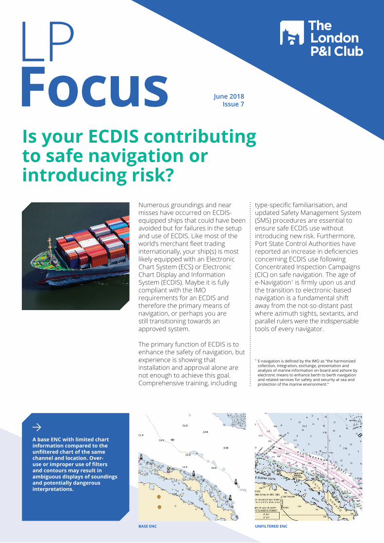
A base ENC with limited chart information compared to the unfiltered chart of the same channel and location. Over-use or improper use of filters and contours may result in ambiguous displays of soundings and potentially dangerous interpretations.
1 E-navigation is defined by the IMO as “the harmonized collection, integration, exchange, presentation and analysis of marine information on board and ashore by electronic means to enhance berth to berth navigation and related services for safety and security at sea and protection of the marine environment.”
UNFILTERED ENCBASE ENC
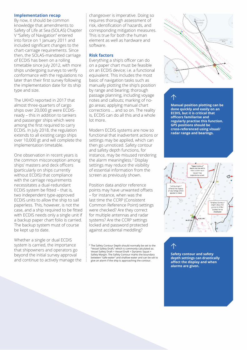
Manual position plotting can be done quickly and easily on an ECDIS, but it is critical that officers familiarise and regularly practise this function. GPS positions should be cross-referenced using visual/radar range and bearings.
Safety contour and safety depth settings can drastically affect the display and when alarms are given.
Implementation recap By now, it should be common knowledge that amendments to Safety of Life at Sea (SOLAS) Chapter V “Safety of Navigation” entered into force on 1 January 2011 and included significant changes to the chart-carriage requirements. Since then, the SOLAS-mandated carriage of ECDIS has been on a rolling timetable since July 2012, with more ships undergoing surveys to verify conformance with the regulations no later than their first survey following the implementation date for its ship type and size.
The UKHO reported in 2017 that almost three-quarters of cargo ships over 20,000 gt were ECDIS-ready – this in addition to tankers and passenger ships which were among the first required to carry ECDIS. In July 2018, the regulation extends to all existing cargo ships over 10,000 gt and will complete the implementation timetable. One observation in recent years is the common misconception among ships’ masters and deck officers (particularly on ships currently without ECDIS) that compliance with the carriage requirements necessitates a dual-redundant ECDIS system be fitted – that is, two independent type-approved ECDIS units to allow the ship to sail paperless. This, however, is not the case, and a ship required to be fitted with ECDIS needs only a single unit if a backup paper chart folio is carried. The backup system must of course be kept up to date. Whether a single or dual ECDIS system is carried, the importance that shipowners and operators go beyond the initial survey approval and continue to actively manage the
changeover is imperative. Doing so requires thorough assessment of risk, identification of hazards, and corresponding mitigation measures. This is true for both the human element as well as hardware and software.
Risk factors Everything a ship’s officer can do on a paper chart must be feasible on an ECDIS device; i.e. a functional equivalent. This includes the most basic of navigation tasks such as manually plotting the ship’s position by range and bearing; thorough passage planning, including voyage notes and callouts; marking of no-go areas; applying manual chart corrections … and so on. The reality is, ECDIS can do all this and a whole lot more.
Modern ECDIS systems are now so functional that inadvertent actions or settings may be applied, which can then go unnoticed. Safety contour and safety depth functions, for instance, may be misused rendering the alarm meaningless.2 Display settings may reduce the visibility of essential information from the screen as previously shown.
Position data and/or reference points may have unwanted offsets – for instance, when was the last time the CCRP (Consistent Common Reference Point) settings were checked? Are they correct for multiple antennas and radar systems? Are the CCRP settings locked and password protected against accidental meddling?
2 The Safety Contour Depth should normally be set to the “Vessel Safety Draft,” which is commonly calculated as: Vessel Safety Draft = Vessel Draft + Dynamic Squat + Safety Margin. The Safety Contour marks the boundary between “safe-water” and shallow water and can be set to give an alarm if the ship is approaching the contour.
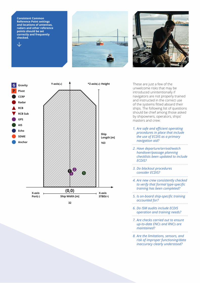
Consistent Common Reference Point settings and locations of antennas, radars and other reference points should be set correctly and frequently checked.
These are just a few of the unwelcome risks that may be introduced unintentionally if navigators are not properly trained and instructed in the correct use of the systems fitted aboard their ships. The following list of questions should be chief among those asked by shipowners, operators, ships’ masters and crew:
1.AresafeandefficientoperatingproceduresinplacethatincludetheuseofECDISasaprimarynavigationaid?
2.Havedeparture/arrival/watchhandover/passageplanningchecklistsbeenupdatedtoincludeECDIS?
3.Doblackoutprocedures considerECDIS?
4.Arenewcrewconsistentlycheckedtoverifythatformaltype-specifictraininghasbeencompleted?
5.Ison-boardship-specifictrainingaccountedfor?
6.DoISMauditsincludeECDISoperationandtrainingneeds?
7.Arecheckscarriedouttoensureup-to-dateENCsandRNCsaremaintained?
8.Arethelimitations,sensors,andriskofimproperfunctioning/datainaccuracyclearlyunderstood?
Y-axis(+) *Z-axis(+): Height
X-axisPort(-)
X-axisSTBD(+)Ship Width [m]
32
(0,0)
ShipLength [m]
163
RCB
RCB Sub
Radar
GPS
AIS
Echo
SDME
Anchor
Gravity
Pivot
CCRP
21 11
When Cross Track Distances are properly set to each leg of a voyage plan then route checking assists in checking for potential obstructions, dangers and insufficient depths.
Common operational mistakesWhen properly operated, ECDIS is an exceptional tool that drastically improves situational awareness and operational efficiency, and can reduce errors. On the other hand, over-reliance or lack of familiarity can lead to calamitous consequences. The term “ECDIS assisted Grounding” has not arisen from nowhere, and based on our experience, recurrent themes often include the following:
Improperuseofcharts:i.e.not
usingorhavingthenecessarychartsfortheintendedvoyageornotapplyingchartupdatesfrequently
andcorrectly.
Notfollowingorbeingawareofthe
manufacturer’ssoftwaremaintenanceupdatesandnotupdatingtheECDIStobecompatiblewiththelatestversionof
theIHOStandards.
Improperuseofsafetysettingsandbuilt-insafeguardssuchasroutecheckingandsafetyalarmsrelated
todepths.
Improperdisplaysettings,filtersandscale.
NotusingtheroutecheckingfunctionatallornotusingitwithanappropriateCross
TrackDistance(XTD).Notvisuallycheckingtherouteatanappropriatescale.
LackoffamiliaritywiththespecificECDIStypeonboard.
Over-relianceonECDISandthedisplayedGPS
position.
Inabilitytouseorlackoffamiliaritywithmanualpositionfixing
functionssuchasrangeandbearings.
Handoverbetweendeck
officersincludingECDIS-relatedinformation.
www.londonpandi.com
Managers A. Bilbrough & Co. Ltd.
GreeceIonion BuildingAkti Miaouli & 2, II Merarchias Street185 35 Piraeus T: +30 210 458 6600F: +30 210 458 6601E: [email protected]
London50 Leman StreetLondon E1 8HQT: +44 20 7772 8000F: +44 20 7772 8200E: [email protected]
Hong KongRoom 1802 Guardian House32 Oi Kwan RoadHong KongT: +852 3761 5678F: +852 2838 2001E: [email protected]
Beyond approval When fitted, ECDIS must be type-approved, conform to the relevant IMO performance standards3, connect to an emergency source of electrical power, and have at least gyrocompass, speed log and GPS receiver inputs. The system must have up-to-date Electronic Nautical Charts (ENC), or Raster Navigation Charts (RNC) where ENCs are not available or of an appropriate scale. All nautical charts for the intended voyage(s) must be installed and maintained to be compatible with the latest applicable International Hydrographic Organization (IHO) chart content and display standards. Backup arrangements must be available, which can be either a secondary type-approved ECDIS or official, up-to-date paper charts.
Beyond the aforesaid general requirements of a SOLAS-compliant ECDIS, shipowners and operators are encouraged to undertake regular risk assessments of ECDIS navigation, including potential over-reliance of the system and improper use of the safety settings.
Periodic evaluation and training of the master and deck officers should highlight the limitations and possible inaccuracies of the ECDIS and its sensors. The need for a proper lookout at all times and by all available means should be emphasised, as well as independent checking of the ship’s position outside of the ECDIS-displayed GPS position. ECDIS is only one of many navigation tools available to the modern navigator, but the dangers of over-reliance are becoming an all too common theme.
For further information on some of the topics discussed here, I recommend the IMO circular: ECDIS – Guidance for Good Practice (MSC.1/Circ.1503/Rev.1).
By Steve CunninghamAssociate Director Shipping Team LeadLondon Offshore Consultants Inc
3 IMO resolution A.817(19), as amended or resolution MSC.232(82), depending on the date of installation.