Embed Size (px)
Citation preview

LP DAAC Web Map Service (WMS)
User Guide Version 1.3
June 13, 2018

2
Table of Contents Introduction ........................................................................................................................................... 3
Service URL .......................................................................................................................................... 3
Available Data Layers .......................................................................................................................... 3
GetCapabilities ...................................................................................................................................... 4
GetMap .................................................................................................................................................. 4
Import WMS layers into a GIS ............................................................................................................ 5
How to add a WMS layers to QGIS ................................................................................................ 5
How to open and browse WMS layers in ArcGIS ........................................................................ 10

3
Introduction The Open Geospatial Consortium (OGC) is an international consortium dedicated to developing
open web service interface standards for geospatial data served over the internet. A web map
service (WMS) is an OGC standard that allows users to remotely access georeferenced map
images via hypertext transfer protocol (HTTP) requests. These images do not transfer raw data
values, but transfer full resolution browse images that are useful as standalone images or as a
base map in a GIS software program. The LP DAAC has made a subset of data products from
the Moderate Resolution Imaging Spectroradiometer (MODIS) collection available as WMS
layers. These layers can be requested and visualized, via HTTP, in an internet browser or in a
program that connects to, and consumes, layers available on a WMS server.
Service URL The service URL is the path to the WMS server that provides the map layers, and is a component
of all WMS requests.
Service URL:
https://lpdaacsvc.cr.usgs.gov/ogc/wms?
Available Data Layers • MOD09A1.006: Terra MODIS, 8-Day, 500 meter, Surface Reflectance, True Color
Composite (Red = band 1, Green = band 4, Blue = band 3)
o Product information
• MOD11A2.006: Terra MODIS, 8-Day, 1,000 meter, Daytime Land Surface Temperature
o Product information
• MOD13Q1.006: Terra MODIS, 16-Day, 250 meter, Normalized Difference Vegetation
Index (NDVI)
o Product information
• MOD14A2.006: Terra MODIS, 8-day, 1,000 meter, Confidence of Fire1
o Product information
• MOD15A2H.006: Terra MODIS, 8-Day, 500 meter, Leaf Area Index
o Product information
• MOD17A2H.006: Terra MODIS, 8-Day, 500 meter, Gross Primary Productivity
o Product information
• MOD44B.006: Terra MODIS, Yearly, 250 meter, Vegetation Continuous Fields
o Product information
1 Areas of fire (combined low, nominal, and high confidence) are displayed in red with NASA’s Blue Marble as the
background layer. Note that there is not a legend for this layer.

4
• MCD12Q1.006: Yearly, 500 meter, Land Cover Type 1: International Geosphere-
Biosphere Programme (IGBP) classification
o Product information
GetCapabilities GetCapabilities requests return information about the WMS service. The information returned
provides the user insight into available map layers, available output formats, supported
coordinate reference systems, and other parameters required to request the map layer from the
WMS server.
GetCapabilities URL:
https://lpdaacsvc.cr.usgs.gov/ogc/wms?service=wms&version=1.3.0&request=GetCapabilities
GetMap GetMap requests retrieve a specified WMS map layer from the WMS server. Below is a series of
GetMap requests. Each link will open a map layer in a web browser window.
• Name: MOD09A1.2018153.006.SurRefl
o GetMap
• Name: MOD11A2.2018153.006.LST_day
o GetMap
• Name: MOD13Q1.2018145.006.NDVI
o GetMap
• Name: MOD14A2.2018153.006.Fire
o GetMap
• Name: MOD15A2H.2018153.006.LAI
o GetMap
• Name: MOD17A2H.2018137.006.GPP
o GetMap
• Name: MOD44B.2016065.006.PTC
o GetMap
• Name: MCD12Q1.2016001.006.LandCover
o GetMap

5
Import WMS layers into a GIS
How to add a WMS layers to QGIS 1. To add a WMS layer to QGIS, go to “Layer” → “Add Layer” → “Add WMS WM(T)S
Layer…” from the standard toolbar in QGIS Desktop.

6
2. Click “New” in the “Add Layer(s) from a WM(T)S Server” window.

7
3. In the “Create a new WMS connection” window, add a name for the new connection and
enter the service URL (https:/lpdaacsvc.cr.usgs.gov/ogc/wms?request=GetCapabilities)
into the appropriate fields. Click “OK”.

8
4. When the “Add Layer(s) from a WM(T)S Server” window is active, click “Connect”.
This will connect to the WMS server and display all available layers. Select your layer of
interest and click “Add”.

9
5. Close the “Add Layer(s) from a WM(T)S Server” window and explore the WMS layer
that has been added to your viewer
10
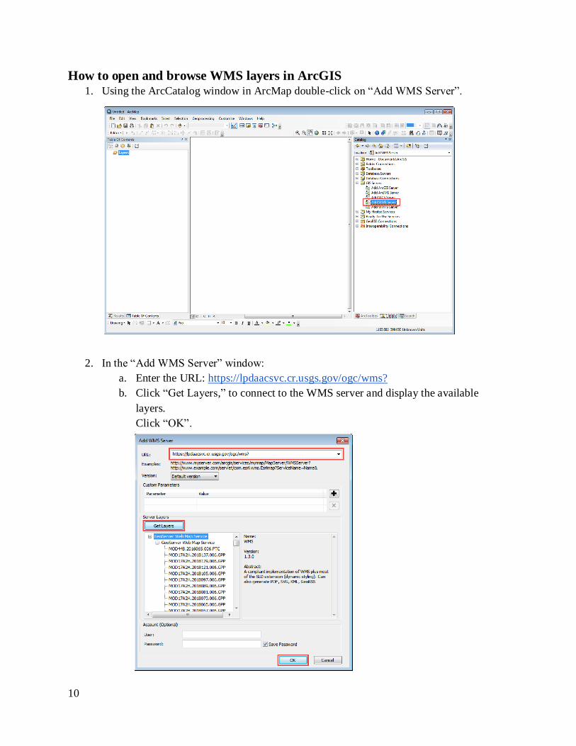
How to open and browse WMS layers in ArcGIS 1. Using the ArcCatalog window in ArcMap double-click on “Add WMS Server”.
2. In the “Add WMS Server” window:
a. Enter the URL: https://lpdaacsvc.cr.usgs.gov/ogc/wms?
b. Click “Get Layers,” to connect to the WMS server and display the available
layers.
Click “OK”.

11
3. Back in the ArcCatalog window in ArcMap:
a. Expand the “GIS Servers” folder and then continue to expand “GeoServer Web
Map Service on lpdaacsvc.cr.usgs.gov” “GeoServer Web Map Service”
“GeoServer Web Map Service”
b. Locate the layer you want to view and drag into the ArcMap display.

12
4. For WMS layers that have an associated legend (e.g. MCD12Q1), the legend can be
added to the map document. To add the WMS Legend to the map:
a. Expand “Geoserver Web Map Service” in the Table of Contents
b. Right click on the layer and click add “WMS Layer to Map.”
c. Right click on the legend and select “Properties” to customize the dimensions of
the legend graphic.