Embed Size (px)
Citation preview
Region 2 serving the people of New Jersey, New York, Puerto Rico and the U.S. Virgin Islands
2/9/2018
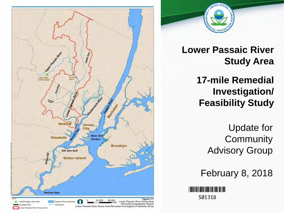
Lower Passaic River Study Area
17-mile Remedial Investigation/
Feasibility Study
Update for Community
Advisory Group
February 8, 2018
.. -~i..., ... - -OD<-•----
Region 2 serving the people of New Jersey, New York, Puerto Rico and the U.S. Virgin Islands
2/9/2018
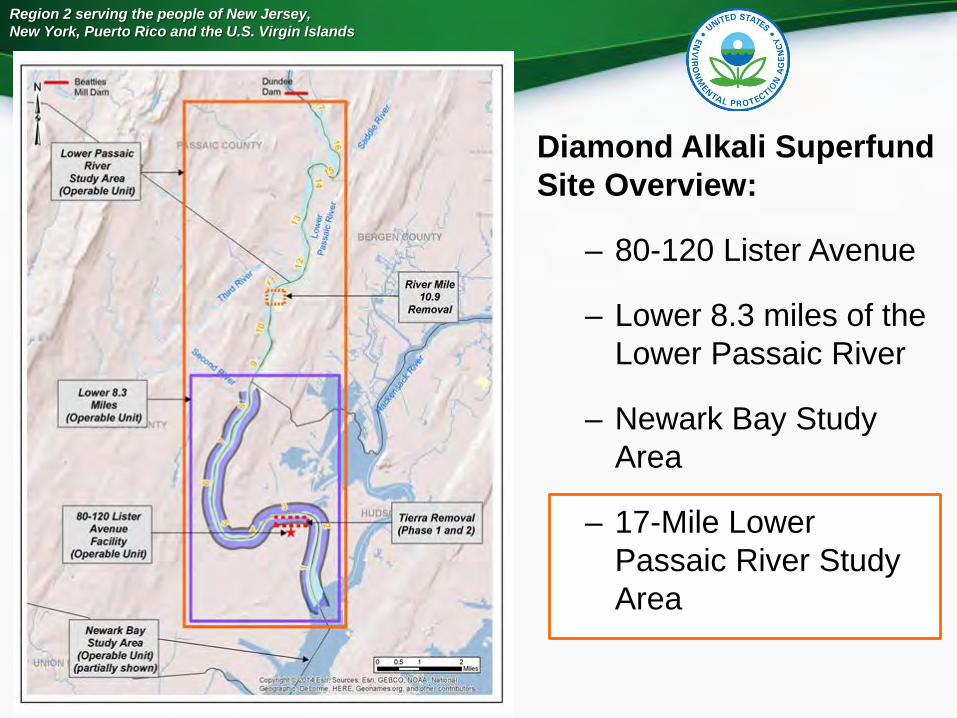
Diamond Alkali Superfund Site Overview:
– 80-120 Lister Avenue
– Lower 8.3 miles of the Lower Passaic River
– Newark Bay Study Area
– 17-Mile Lower Passaic River Study Area
Lower Passaic River
Swd)'Area (Operable Unit)
Lower8.3 Mll&s
(Operable Unit)
80-120 Lister Avenue Facility
(Operable Unit)
Newark Bay Study Area
(Operable Unit) (partially shown)
Region 2 serving the people of New Jersey, New York, Puerto Rico and the U.S. Virgin Islands
2/9/2018
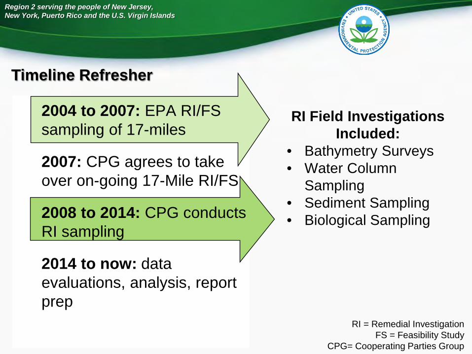
Timeline Refresher
2004 to 2007: EPA RI/FS sampling of 17-miles
2007: CPG agrees to take over on-going 17-Mile RI/FS
2008 to 2014: CPG conducts RI sampling
2014 to now: data evaluations, analysis, report prep
RI Field Investigations Included:
• Bathymetry Surveys• Water Column
Sampling • Sediment Sampling• Biological Sampling
RI = Remedial InvestigationFS = Feasibility Study
CPG= Cooperating Parties Group
imeline e resher
Region 2 serving the people of New Jersey, New York, Puerto Rico and the U.S. Virgin Islands
2/9/2018
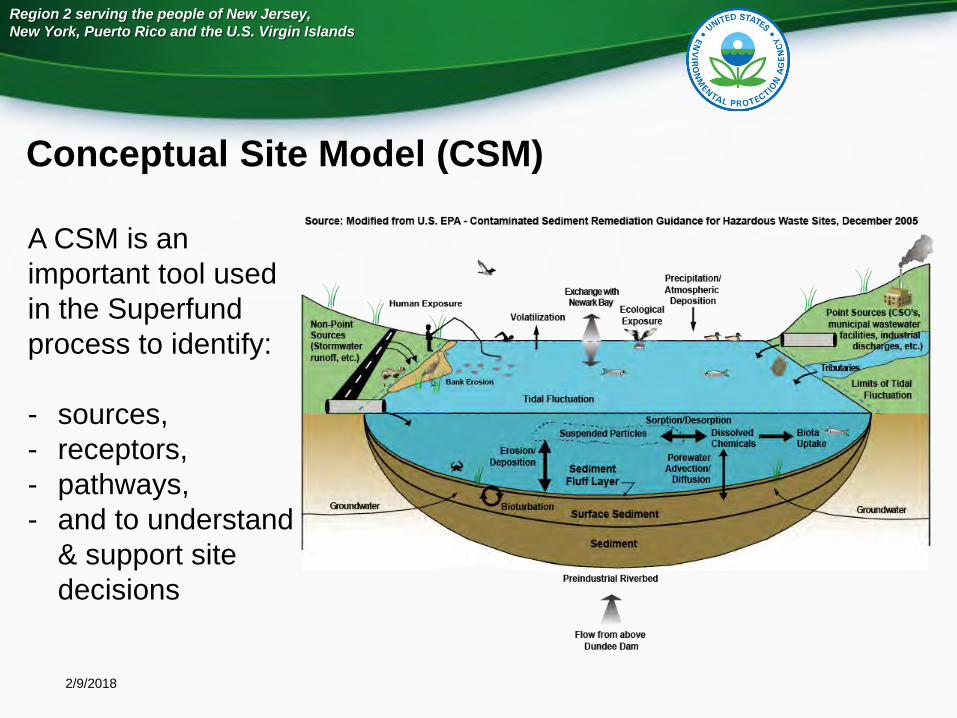
Conceptual Site Model (CSM)
A CSM is an important tool used in the Superfund process to identify:
- sources, - receptors, - pathways, - and to understand
& support site decisions
Source: Modified from U.S. EPA - Contaminated Sediment Remediation Guidance for Hazardous Waste Sites, December 2005
Volatilization
Tidal Fluctuallon
Preindustrial Riverbed
Flow from above Dundee Dam
Precipitation/ Atmospheric
Deposition
!
Gomdwaler
Region 2 serving the people of New Jersey, New York, Puerto Rico and the U.S. Virgin Islands
2/9/2018
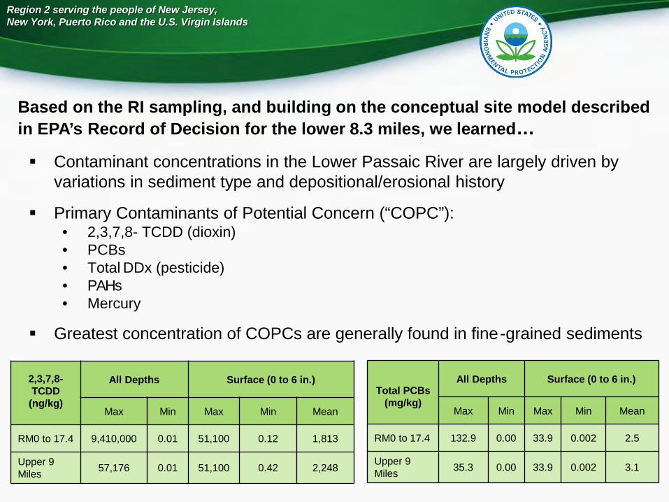
Contaminant concentrations in the Lower Passaic River are largely driven by variations in sediment type and depositional/erosional history
Primary Contaminants of Potential Concern (“COPC”):• 2,3,7,8- TCDD (dioxin)• PCBs• Total DDx (pesticide) • PAHs• Mercury
Greatest concentration of COPCs are generally found in fine-grained sediments
Based on the RI sampling, and building on the conceptual site model described in EPA’s Record of Decision for the lower 8.3 miles, we learned…
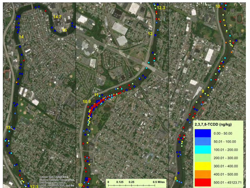
2,3,7,8-TCDD
(ng/kg)
All Depths Surface (0 to 6 in.)
Max Min Max Min Mean
RM0 to 17.4 9,410,000 0.01 51,100 0.12 1,813
Upper 9 Miles 57,176 0.01 51,100 0.42 2,248
Total PCBs(mg/kg)
All Depths Surface (0 to 6 in.)
Max Min Max Min Mean
RM0 to 17.4 132.9 0.00 33.9 0.002 2.5
Upper 9 Miles 35.3 0.00 33.9 0.002 3.1
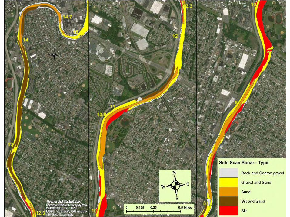
N W+E __ ....,.,.,,, s
Rock and Coarse gravel
Gravel and Sand
Sand
Silt and Sand
Silt
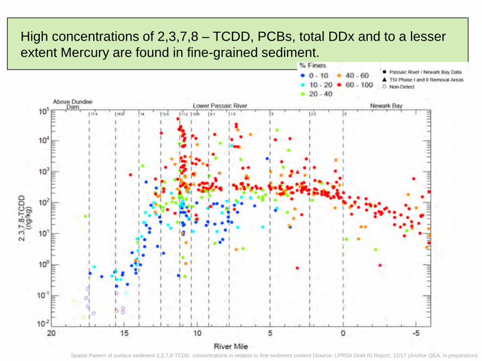
High concentrations of 2,3,7,8 – TCDD, PCBs, total DDx and to a lesser extent Mercury are found in fine-grained sediment.
Spatial Pattern of surface sediment 2,3,7,8-TCDD concentrations in relation to fine sediment content (Source: LPRSA Draft RI Report, 12/17 (Anchor QEA, in preparation)
"'~-· ~----------------------------------- • Pns:s31c R:,vc, / ~ E.:,y o-.i
0 0 o ~ .... "' ' o!!: O) o,
· c: ..... ~ M N
• 0- 10 • 10 - 20 • 20 - 40
Abo\! Oundoo
• 40-60 • 60-100
• T$ P l\ibe I .w,,;J 11 Jllet))Ool.-1 ~
0 Hc:noOW-cl
Lower Po.s.st1tt Rivor N<i-work 10S.,,--,lll!W,.--,,.-, ---,.-.---.-,.-.-,-,,-.,~-,.,.,,-, -,~.r"':::,-.,-", :..:;::,e.,,:.:,_;:::..-,.--.-,--.--.--,-.,,--.---,-,-,--';:,:.:.,::;::.:::~--,--.,
1o'
10'
102
• I
101
I ~· I • 10·1 4 o,
'l ,o
I
~ I
•1 I
\ ~. , . I •
I I • , . , •• • 1 •• I • 1.._ I
• I I • J . I • I I I I I • ll;,i._ .. 1 • 1 • • • • • 1 • 1 1• I • • 6 I • , I • • ~ • • • I • • I
• I • I , I • I .. I • ' • I • el
I • • I" .._ ~ · I -.:'I,,,, l,..Se,: •.t.1 •••• , "'' • I • • l' _ • ..,~. -L• , • • , . , , ~·• •t • • .. ......... ,,,I~.. "" . . ,. ... ;., : . . I • ' , ••
I • • \ ti • ,.., , • I • 2 • • : • I •
• • • .,.. . . " .. ......
I '\, t • • 11, 1f ., . • 'I• I • • • • • I • I 10 19 • • .. • • • •••• • I
"' •i.! • • I> I
b8 I
15
1•• I I • I • •• J • • I I I
• 1 • 1• •• I .c~ I I o 1 SI I I I
I ~ • 1 I I I I I I
• •
River Mile
•
It • I
I • •
• • •
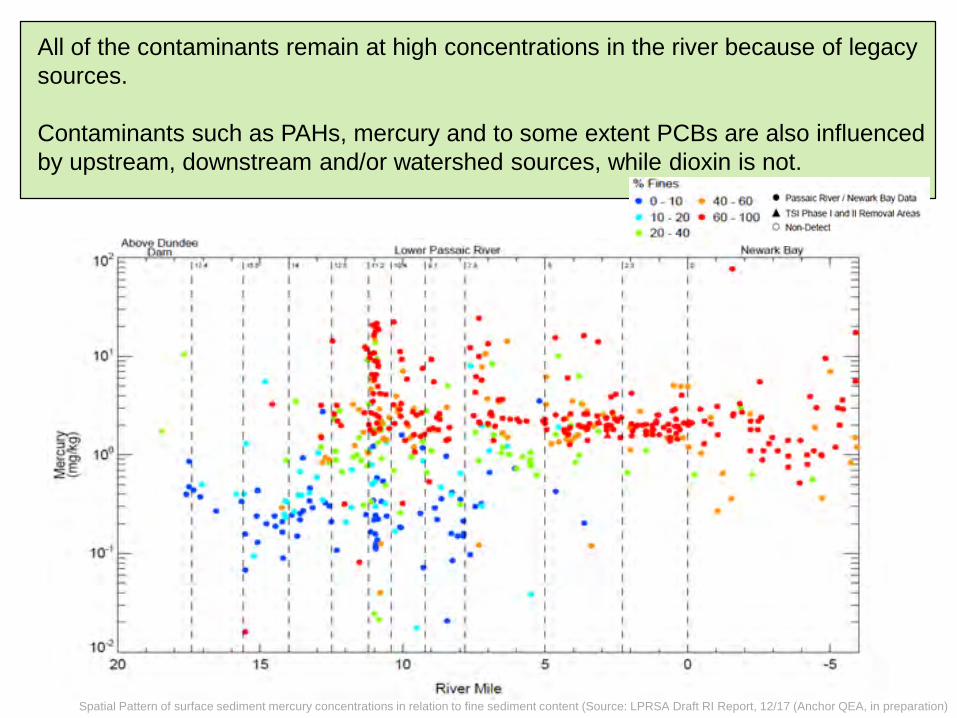
All of the contaminants remain at high concentrations in the river because of legacy sources.
Contaminants such as PAHs, mercury and to some extent PCBs are also influenced by upstream, downstream and/or watershed sources, while dioxin is not.
Spatial Pattern of surface sediment mercury concentrations in relation to fine sediment content (Source: LPRSA Draft RI Report, 12/17 (Anchor QEA, in preparation)
. 1 I I I I I
I
41 1 . ~-I ,.
0-
.. •
r I
• •
,.
•
• •
! ·•-,., •1. I ., I 1: • 1 I I
I I I
i"'
1111 . ,
I ., I
• I
• I • I I I
••• I
I I I •· ..
• .1. 1 • I I
"
• • • • .. .. ~,..,
-ve:r Mile,
I ,., ., •
I •
., I
1 • I
• I I
• •
• 1111
•
I J
I
,. I 1•
I I
ine • 0- 0
10-20 20 - 4-0
I
·:+
• 40- 0 • P-.1~
• G0-100 "
•
• •
!I
1111 • .. , .... Ii
• • I 1• I I •
l • • . ,., -. . . • • ••• • • • . ,.
0.00 - 50.00
50.01 - 100.00
100.01 - 200.00
200.01 - 300 00
300.01 - 400.00
400.01 - 500.00
500.01 - 45123.71

Region 2 serving the people of New Jersey, New York, Puerto Rico and the U.S. Virgin Islands
2/9/2018
Density gradients combined with tides
contribute to residual flow shown
Newark Bay
Dundee Dam
Tidal Exchange with Newark
Bay
Net Transport “In” Near Bottom
Net Transport “Out” Near Surface
Vertical movement and Diffusion
Example of Water Circulation in the Lower Passaic River
> c:::::> -----1t---n---t--------
-- -- ~:--=~--==-- < <-----n
Region 2 serving the people of New Jersey, New York, Puerto Rico and the U.S. Virgin Islands
2/9/2018
We also learned:
• Contaminated sediments may serve as a source to the water column, and therefore other areas of the river, when concentrations in the sediments are higher than the concentrations found on particles in the water column
• Contaminated sediments can be a source through resuspension from tidal influences or high flow events such as storms
Region 2 serving the people of New Jersey, New York, Puerto Rico and the U.S. Virgin Islands
2/9/2018
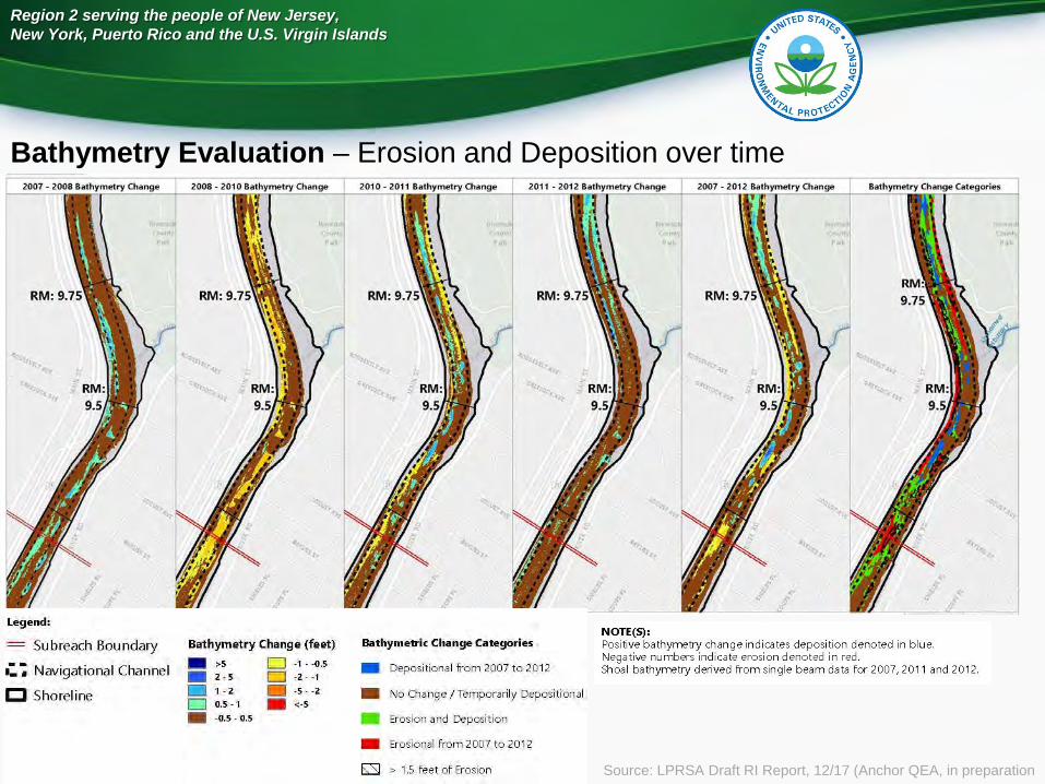
Bathymetry Evaluation – Erosion and Deposition over time
Source: LPRSA Draft RI Report, 12/17 (Anchor QEA, in preparation
, 2007 - 2008 Bathymetry Chong __ • ___ 2_oos • 2010 Bathymelry Change - - - ~r ~
Legend:
- Su breach Boundary Bathymetry Change (feet)
--Navigational Channel ->S D -1 - -0.S ·-. -2 - S D -2 - -1
CJ Shorel ine -1 - 2 --S - -2
D 0.5 - 1 -<-5 --0.S · 0 .5
2011 • 201 2 Bothymetry Change
Bathymetric Change Categories
- Depositional from 2007 to 2012
- No Change/ Temporarily Depositional
- Erosion and Deposi tion
- Erosional from 2007 to 2012
E:SI > 1.5 feet of Erosion
NOTE(S) : Positive bathymetry mange indicates deposition denoted in blue. Negative numbers indicate erosion denoted in red. Shoal bathymetry derived from single beam data for 2007, 2011 and 2012.
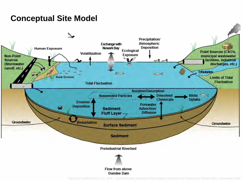
Figure is modified from U.S. EPA – Contaminated Sediment Remediation Guidance for Hazardous Waste Sites, December 2005
Conceptual Site Model
Precipitation/ Exchange will Atmospheric \ I, Newa!l(Bay Deposition }fl
Ecological ! Point Sources (CSO's, Exposure municipal --~ ~ ___'.__:.d..::::L-d-===:J ::,__ _ facilities, in
Tidal Fluctuation
Preindustrial Riverbed
Flow from above Dundee Dam
' • ,, dis , etc.)
, Limits of Tidal ' , Fluctuation
'
Region 2 serving the people of New Jersey, New York, Puerto Rico and the U.S. Virgin Islands
2/9/2018
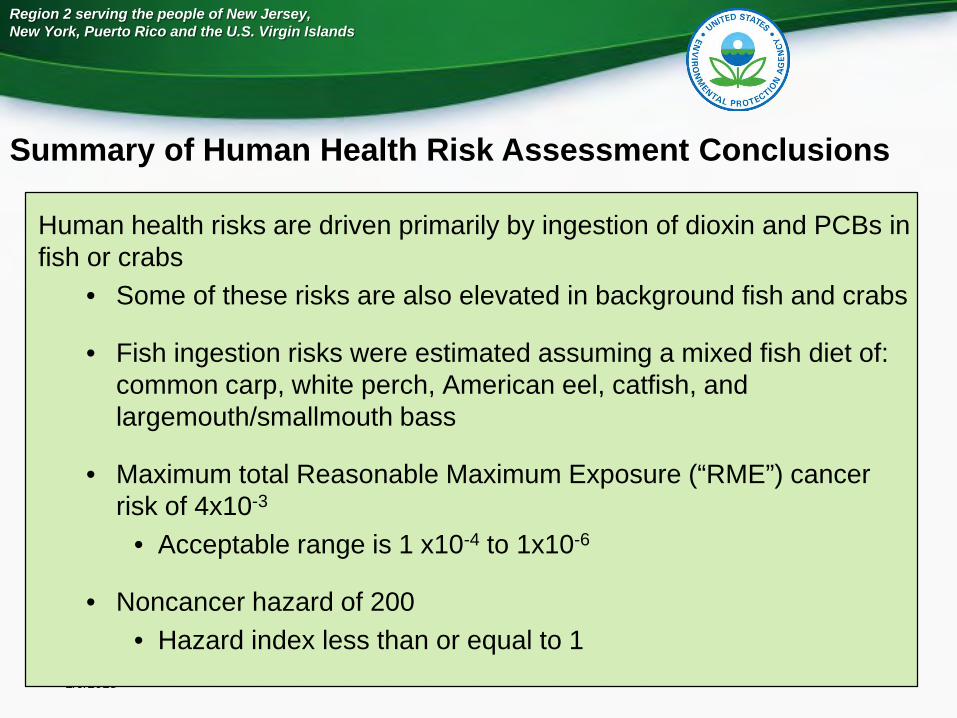
Summary of Human Health Risk Assessment Conclusions
Human health risks are driven primarily by ingestion of dioxin and PCBs in fish or crabs
• Some of these risks are also elevated in background fish and crabs
• Fish ingestion risks were estimated assuming a mixed fish diet of: common carp, white perch, American eel, catfish, and largemouth/smallmouth bass
• Maximum total Reasonable Maximum Exposure (“RME”) cancer risk of 4x10⁻³
• Acceptable range is 1 x10⁻⁴ to 1x10⁻⁶
• Noncancer hazard of 200• Hazard index less than or equal to 1
Region 2 serving the people of New Jersey, New York, Puerto Rico and the U.S. Virgin Islands
2/9/2018
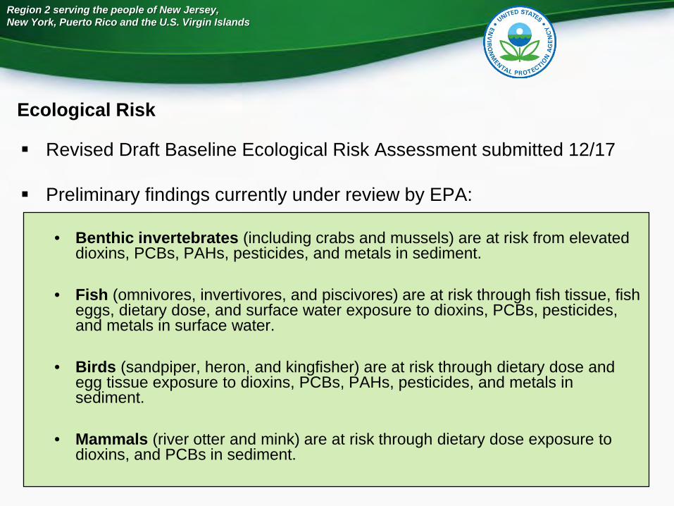
Ecological Risk
Revised Draft Baseline Ecological Risk Assessment submitted 12/17
Preliminary findings currently under review by EPA:
• Benthic invertebrates (including crabs and mussels) are at risk from elevated dioxins, PCBs, PAHs, pesticides, and metals in sediment.
• Fish (omnivores, invertivores, and piscivores) are at risk through fish tissue, fish eggs, dietary dose, and surface water exposure to dioxins, PCBs, pesticides, and metals in surface water.
• Birds (sandpiper, heron, and kingfisher) are at risk through dietary dose and egg tissue exposure to dioxins, PCBs, PAHs, pesticides, and metals in sediment.
• Mammals (river otter and mink) are at risk through dietary dose exposure to dioxins, and PCBs in sediment.
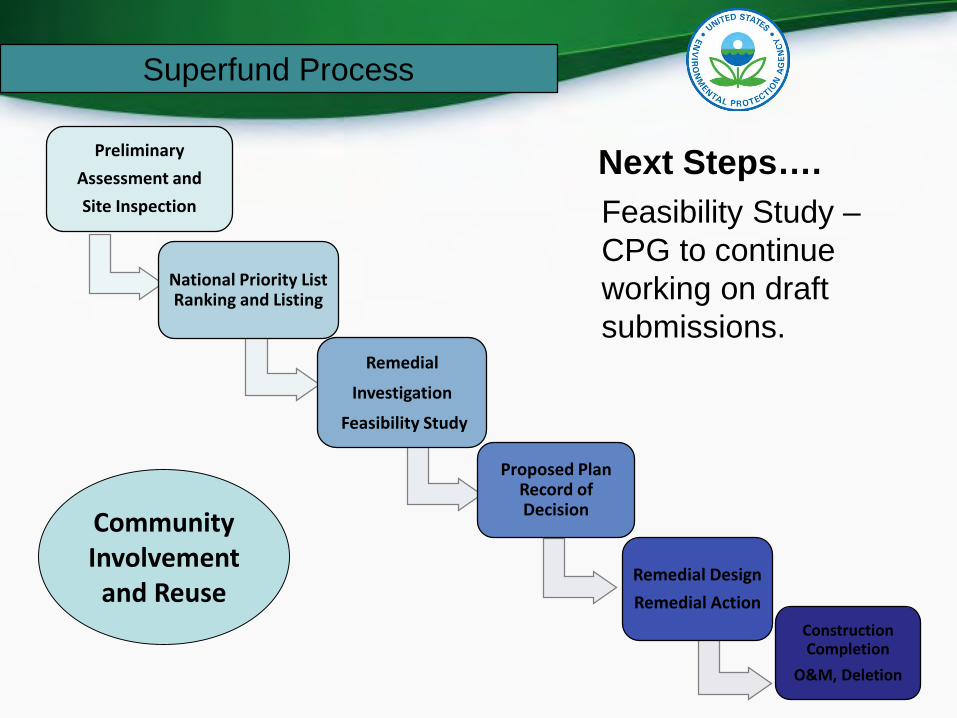
Next Steps….Feasibility Study –CPG to continue working on draft submissions.
Preliminary Assessment andSite Inspection
National Priority List Ranking and Listing
Remedial
Investigation
Feasibility Study
Proposed Plan Record of Decision
Remedial DesignRemedial Action
Construction Completion
O&M, Deletion
CommunityInvolvement
and Reuse
Superfund Process