Embed Size (px)
Citation preview

LLoowweerr OOrraannggee RRiivveerr MMaannaaggeemmeenntt PPllaann Unlocking the Ecotourism Potential of the River
Draft, October 2008
/Ai/Ais-Richtersveld Transfrontier Park ~ Oorgrenspark ~ !Am //Aesa /Guru !Hânab
Joint Management Board ~ Gesamentlike Bestuursraad ~ /Hûbe-ra ≠Gae ≠Gui !Nâns


Lower Orange River Management Plan Unlocking the Ecotourism of the River
Draft, October 2008
Facilitated and Compiled by:
Mapping by:
Funded by:
Compiled for:
/Ai/Ais-Richtersveld Transfrontier Park ~ Oorgrenspark ~ !Am //Aesa /Guru !Hânab
Joint Management Board (JMB) ~ Gesamentlike Bestuursraad ~ /Hûbe-ra ≠Gae ≠Gui !Nâns Copies of this Report can be obtained from: Karl Mutani Aribeb International Coordinator: /Ai/Ais-Richtersveld Transfrontier Park (ARTP) PO Box 98152 Windhoek Namibia Tel: +264 61 217643 Mobile: +264811485578 e-mail: [email protected] Room 116 PZN Building, Ruhr Street, Northern Industrial Area Citation ARTP JMB. 2008. “Lower Orange River Management Plan.” Unlocking the Ecotourism Potential of the River, ix + 181 pp


LORMP – Unlocking the Ecotourism Potential of the River, Draft October 2008
RECOMMENDATIONS AND APPROVALS
Recommendations:
Namibia Chairperson: ARTP JMB South Africa Chairperson: ARTP JMB Date: Date: Chairperson: Permanent Water Commission Date: Approvals: Namibian Minister of Environment and Tourism Date: South African Minister of Environmental Affairs and Tourism Date: Namibian Minister of Agriculture, Water and Forestry Date: South African Minister of Water Affairs and Forestry Date:


LORMP – Unlocking the Ecotourism Potential of the River, Draft October 2008
TABLE OF CONTENTS
Table of Contents............................................................................................................................................ i
List of Maps ................................................................................................................................................... iv
List of Figures ............................................................................................................................................... vi
List of Tables ................................................................................................................................................ vii
Abbreviations/Acronyms............................................................................................................................. vii
Content Summary ......................................................................................................................................... ix
1 ...................................................................................................................................... 3 INTRODUCTION
1.1 .......................................................................................................... 3 Purpose and Aim of Document1.2 .................................................................................................................................... 6 Project Scope1.3 ....................................................................................................................... 10 Participatory Process
2 ............................................................................................................................................ 15 THE PLACE
2.1 ........................................................................................................................ 15 Natural Environment2.1.1 .................................................................................................. 16 Geology and Geomorphology2.1.2 ................................................................................................................................... 19 Elevation2.1.3 ........................................................................................................................................ 19 Slope2.1.4 ..................................................................................................................... 22 River Landscapes2.1.5 ................................................................................................. 31 Riverine and Riparian Ecology2.1.6 ................................................................................................................... 32 Terrestrial Ecology2.1.7 ..................................................................................................................................... 34 Climate
2.1.7.1 .................................................................................................................................. 34 Rainfall2.1.7.2 ......................................................................................................................... 35 Temperature
2.1.8 ........................................................................................................................................ 35 Water2.1.8.1 .............................................................................................................................. 35 Hydrology2.1.8.2 ........................................................................................................................ 39 Water Quality
2.2 ....................................................................................................................... 40 Cultural Environment2.3 ..................................................................................................................... 41 Business Environment
2.3.1 ....................................................................................................... 41 Current Land Use Patterns2.3.1.1 ................................................................................................................................... 43 Mining2.3.1.2 ............................................................................................................................. 43 Agriculture2.3.1.3 ....................................................................................... 44 River-based Operations (Tourism)
2.3.2 .......................................................................................................... 47 Detractors to Ecotourism2.3.2.1 ................................................................................................................................... 47 Mining2.3.2.2 ............................................................................................................................. 47 Agriculture2.3.2.3 ........................................................................................................... 47 General Infrastructure2.3.2.4 .................................................................................................................................. 50 Fishing
2.3.3 ....................................................................................................... 50 Contributors to Ecotourism2.3.3.1 .................................................................................................................... 50 Protected Areas2.3.3.2 ........................................................................................................... 51 Tourism Infrastructure
2.4 ........................................................................................................................ 52 Tenure Environment2.4.1 ......................................................................................................... 52 Land Ownership and Use
2.5 ................................................................................................................ 53 Governance Environment2.5.1 ........................................................................................................................... 53 Administration
2.5.1.1 ........................................................................................................... 53 Cadastral Information2.5.1.2 ....................................................................................................................... 54 Demographics
2.5.2 ...................................................................................................................... 54 Legal Framework2.5.2.1 ................................................................................................... 54 Transfrontier Conservation2.5.2.2 .............................................................................................. 55 Water Resource Management2.5.2.3 .............................................................................................................. 56 Border Demarcation
2.5.3 ........................................................................................................ 57 Institutional Arrangements2.5.3.1 ................................................................................................... 57 Transfrontier Conservation2.5.3.2 .............................................................................................. 57 Water Resource Management
- i -
LORMP – Unlocking the Ecotourism Potential of the River, Draft October 2008
2.5.4 ................................................................................................................ 57 Planning Framework
3 ......................................................................................................................................... 63 THE PEOPLE
3.1 S ....................................................................................................... 63 takeholders and Role Players3.1.1 ................................................................................................................. 63 Resource Managers3.1.2 .............................................................................................................................. 64 Landowners3.1.3 ........................................................................................................................... 65 River Industry3.1.4 .............................................................................................................................. 65 Government
3.2 .................................................................................................................. 66 Needs and Expectations3.2.1 ......................................................................................... 66 Resource Management Community3.2.2 ........................................................................................................... 66 Land Owners and Users3.2.3 ...................................................................................... 67 River Industry (Business Community)3.2.4 .............................................................................................................................. 67 Government
4 .............................................................................................................................................. 71 THE PLAN
4.1 .................................................................................................................. 71 Management Objectives4.1.1 ...................................................................................................................... 71 Overall Objective4.1.2 ................................................................................................................... 71 Specific Objectives
4.2 ....................................................................................................................... 71 Concept Master Plan4.2.1 ..................................................................................................................... 71 Planning Process4.2.2 ............................................................................................. 73 Current Environmental Character4.2.3 ................................................................................................................ 77 Future Desired State
4.3 ............................................................ 78 Concept Master Plan: Detailed River Section Descriptions4.3.1 ..................................................................................................... 80 River Section 1 (Augrabies)
4.3.1.1 ................................................................................................ 80 Integrated Concept Proposal4.3.1.2 ........................................................................................................................... 81 Sensitivities4.3.1.3 ....................................................................................... 82 Concept Development Plan (CDP)4.3.1.4 .................................................................................................................. 83 Requisite Actions
4.3.2 ............................................................................................... 87 River Section 2 (Riemvasmaak)4.3.2.1 ................................................................................................ 87 Integrated Concept Proposal4.3.2.2 ........................................................................................................................... 88 Sensitivities4.3.2.3 ...................................................................................................................................... 89 CDP4.3.2.4 .................................................................................................................. 90 Requisite Actions
4.3.3 ................................................................................................. 94 River Section 3 (Onseepkans)4.3.3.1 ................................................................................................ 94 Integrated Concept Proposal4.3.3.2 ........................................................................................................................... 95 Sensitivities4.3.3.3 ...................................................................................................................................... 96 CDP4.3.3.4 .................................................................................................................. 97 Requisite Actions
4.3.4 ................................................................................................. 102 River Section 4 (Oranjevalle)4.3.4.1 .............................................................................................. 102 Integrated Concept Proposal4.3.4.2 ......................................................................................................................... 103 Sensitivities4.3.4.3 .................................................................................................................................... 104 CDP4.3.4.4 ................................................................................................................ 105 Requisite Actions
4.3.5 ............................................................................................................ 108 River Section 5 (Pella)4.3.5.1 .............................................................................................. 108 Integrated Concept Proposal4.3.5.2 ......................................................................................................................... 109 Sensitivities4.3.5.3 .................................................................................................................................... 110 CDP4.3.5.4 ................................................................................................................ 112 Requisite Actions
4.3.6 ................................................................................................. 118 River Section 6 (Goodhouse)4.3.6.1 .............................................................................................. 118 Integrated Concept Proposal4.3.6.2 ......................................................................................................................... 119 Sensitivities4.3.6.3 .................................................................................................................................... 120 CDP4.3.6.4 ................................................................................................................ 121 Requisite Actions
4.3.7 .................................................................................................... 125 River Section 7 (Vioolsdrift)4.3.7.1 .............................................................................................. 125 Integrated Concept Proposal4.3.7.2 ......................................................................................................................... 126 Sensitivities4.3.7.3 .................................................................................................................................... 126 CDP4.3.7.4 ................................................................................................................ 127 Requisite Actions
4.3.8 ...................................................................................... 129 River Section 8 (Richtersveld WHS)
- ii -

LORMP – Unlocking the Ecotourism Potential of the River, Draft October 2008
4.3.8.1 .............................................................................................. 129 Integrated Concept Proposal4.3.8.2 ......................................................................................................................... 130 Sensitivities4.3.8.3 .................................................................................................................................... 131 CDP4.3.8.4 ................................................................................................................ 132 Requisite Actions
4.3.9 ................................................................................................. 137 River Section 9 (Aussenkehr)4.3.9.1 .............................................................................................. 137 Integrated Concept Proposal4.3.9.2 ......................................................................................................................... 138 Sensitivities4.3.9.3 .................................................................................................................................... 139 CDP4.3.9.4 ................................................................................................................ 139 Requisite Actions
4.3.10 ........................................................................................................ 142 River Section 10 (ARTP)4.3.10.1 .............................................................................................. 142 Integrated Concept Proposal4.3.10.2 ......................................................................................................................... 144 Sensitivities4.3.10.3 .................................................................................................................................... 146 CDP4.3.10.4 ................................................................................................................ 157 Requisite Actions
4.3.11 ............................................................................................... 159 River Section 11 (Sperrgebiet)4.3.11.1 .............................................................................................. 159 Integrated Concept Proposal4.3.11.2 ......................................................................................................................... 160 Sensitivities4.3.11.3 .................................................................................................................................... 161 CDP4.3.11.4 ................................................................................................................ 161 Requisite Actions
4.3.12 .............................................................................................. 164 River Section 12 (Oranjemund)4.3.12.1 .............................................................................................. 164 Integrated Concept Proposal4.3.12.2 ......................................................................................................................... 165 Sensitivities4.3.12.3 .................................................................................................................................... 167 CDP4.3.12.4 ................................................................................................................ 167 Requisite Actions
4.4 ................................................................................................. 170 Proposed Operational Framework4.5 .......................................................................................................................... 180 Institutionalisation
4.5.1 .................................................................................. 181 Conservation Coordination Committee4.5.2 .................................................................................... 181 Landowners Coordination Committee4.5.3 ...................................................................................... 181 Ecotourism Coordination Committee4.5.4 .................................................................................... 182 Government Coordination Committee4.5.5 ................................................................................. 182 International and Country Coordinators
REFERENCES............................................................................................................................................. 183
- iii -

LORMP – Unlocking the Ecotourism Potential of the River, Draft October 2008
LIST OF MAPS
Map 1: ..................... 6 Lower Orange River Management Plan Study Area and Scope – Protected AreasMap 2: ............................................................................................................... 7 Augrabies – OnseepkansMap 3: ........................................................................................................... 8 Onseepkans – NoordoewerMap 4: ............................................................................................... 8 Noordoewer – Orange River MouthMap 5: ................................................................................................................. 9 River Planning SectionsMap 6: ........................................................................................................................................ 16 GeologyMap 7: ...................................................................................................................................... 20 ElevationMap 8: ............................................................................................................................................ 21 SlopeMap 9: ...................................................................................... 24 River Landscape Section 1 (Augrabies)Map 10: ................................................................................ 24 River Landscape Section 2 (Riemvasmaak)Map 11: ................................................................................. 25 River Landscape, Section 3 (Onseepkans)Map 12: ................................................................................... 25 River Landscape, Section 4 (Oranjevalle)Map 13: .............................................................................................. 26 River Landscape, Section 5 (Pella)Map 14: ................................................................................... 26 River Landscape, Section 6 (Goodhouse)Map 15: ...................................................................................... 27 River Landscape, Section 7 (Vioolsdrift)Map 16: .................................................................................. 27 River Landscape, Section 8 (Richtersveld)Map 17: .................................................................................. 28 River Landscape, Section 9 (Aussenkehr)Map 18: .......................................................................................... 28 River Landscape, Section 10 (ARTP)Map 19: ................................................................................. 29 River Landscape, Section 11 (Sperrgebiet)Map 20: ................................................................................ 29 River Landscape, Section 12 (Oranjemund)Map 21: .................................................................................................................................... 33 VegetationMap 22: ......................................................................................... 33 Protection Status of Vegetation (RSA)Map 23: ............................................................................................................................ 34 Rainfall DivisionMap 24: ................................................................................................................ 35 Rainfall per CatchmentMap 25: ................................................................................................................................. 36 TemperatureMap 26: ........................................................................................................................................... 36 RunoffMap 27: ...................................................................................................................... 41 Cultural LandscapeMap 28: ....................................................................................................... 42 Current Land Use – NamibiaMap 29: ................................................................................................. 42 Current Land Use – South AfricaMap 30: ............................................................................................................................. 44 Mining ImpactsMap 31: ........................................................................... 45 Current River Use - Augrabies to OnseepkansMap 32: ....................................................................... 46 Current River Use – Onseepkans to NoordoewerMap 33: ........................................................................ 46 Current River Use – Noordoewer to OranjemundMap 34: ...................... 48 Dam Walls and Weirs (Beenbreek, Yasriviermond, Goodhouse, Henkriesmond)Map 35: ........................................................................... 49 Dam Walls and Weirs (Vioolsdrift, Nooroewer)Map 36: ......................................................................................................... 49 Bridges and Pump StationsMap 37: ........................................................................................................................... 51 Protected AreasMap 38: ............................................................................................................ 52 Land Ownership and UseMap 39: ................................................................................................................... 53 Cadastral InformationMap 40: ............................................................................................................. 58 Scope of Namibian ICDPMap 41: ....................................................................................... 59 Proposed RSA ICDP Land Use ZoningMap 42: ...................................................... 74 Audio-visual Impacts – Cluster 1, Augrabies to OnseepkansMap 43: ............................................................................... 74 CEC – Cluster 1, Augrabies to OnseepkansMap 44: .................................................. 75 Audio-visual Impacts – Cluster 2, Onseepkans to NoordoewerMap 45: ............................................................................ 75 CEC – Cluster 2, Onseepkans to NoordoewerMap 46: ................................................... 76 Audio-visual Impacts – Cluster 3, Noordoewer to OranjemundMap 47: ............................................................................ 76 CEC – Cluster 3, Noordoewer to OranjemundMap 48: .................................................................................................................... 77 Future Desired StateMap 49: ............................................................................................................... 79 River Planning SectionsMap 50: ....................................................................................... 81 Habitat Integrity, Section 1 (Augrabies)Map 51: ......................................................................................................... 84 CDP, Section 1 (Augrabies)Map 52: .................................................... 85 CDP, Section 1 (Augrabies Falls Rest Camp Adventure Hub)Map 53: ...................................................................... 85 CDP, Section 1 (Wabrand Wilderness Camp Site)Map 54: .................................................................................. 86 CDP, Section 1 (Blouputs Adventure Hub)Map 55: ................................................................................ 88 Habitat Integrity, Section 2 (Riemvasmaak)Map 56: .................................................................................................. 91 CDP, Section 2 (Riemvasmaak)
- iv -

LORMP – Unlocking the Ecotourism Potential of the River, Draft October 2008
Map 57: .................................................................................. 92 CDP, Section 2 (Blouputs Adventure Hub)Map 58: ........................................... 92 CDP, Section 2 (Daberas take out point and Biesie se Loop WCS)Map 59: .................................................................................. 93 CDP, Section 2 (Kwaaiputs take out point)Map 60: ................................................................................... 95 Habitat Integrity, Section 3 (Onseepkans)Map 61: ..................................................................................................... 98 CDP, Section 3 (Onseepkans)Map 62: ........................................................................................... 99 CDP, Section 3 (Byna Bo Trailhead)Map 63: ....................................................................... 99 CDP, Section 3 (Skuitdrif Wilderness Camp Site)Map 64: ............................................................... 100 CDP, Section 3 (Rock Island Wilderness Camp Site)Map 65: ................................................................... 100 CDP, Section 3 (Raap-en-Skraap Adventure Hub)Map 66: ................................................................. 101 CDP, Section 3 (Beenbreek Wilderness Camp Site)Map 67: ................................................................................... 101 CDP, Section 3 (Onseepkans Trailhead)Map 68: ................................................................................... 103 Habitat Integrity, Section 4 (Oranjevalle)Map 69: ..................................................................................................... 106 CDP, Section 4 (Oranjevalle)Map 70: .............................................................. 107 CDP, Section 4 (Oranjevalle Wilderness Camp Sites)Map 71: ................................................................................ 107 CDP, Section 4 (Coboop Training Centre)Map 72: ............................................................................................. 110 Habitat Integrity, Section 5 (Pella)Map 73: ............................................................................................................... 113 CDP, Section 5 (Pella)Map 74: ...................................................................................... 114 CDP, Section 5 (Pella Adventure Hub)Map 75: ................................................................ 114 CDP, Section 5 (Kambreek Wilderness Camp Sites)Map 76: ........................................................ 115 CDP, Section 5 (Kum Kum Falls Wilderness Camp Sites)Map 77: .................................................................................... 115 CDP, Section 5 (Houmsrivier Trailhead)Map 78: ............................................................................. 116 CDP, Section 5 (Houmsrivier Desert Camp)Map 79: ................................................. 116 CDP, Section 5 (Grootmelkhoutboom Wilderness Camp Site)Map 80: .................................................................................... 117 CDP, Section 5 (Goodhouse Trailhead)Map 81: ................................................................................... 120 Habitat Integrity, Section 6 (Goodhouse)Map 82: .................................................................................................... 122 CDP, Section 6 (Goodhouse)Map 83: ................................................................................... 123 CDP, Section 6 (Henkries River Camps)Map 84: .................................................................. 123 CDP, Section 6 (Kromrivier Wilderness Camp Site)Map 85: ....................................................................... 124 CDP, Section 6 (Matjies Wilderness Camp Site)Map 86: ........................................................................................ 124 CDP, Section 6 (Vioolsdrif Trailhead)Map 87: ..................................................................................... 126 Habitat Integrity, Section 7 (Vioolsdrift)Map 88: ....................................................................................................... 128 CDP, Section 7 (Vioolsdrift)Map 89: ........................................................................ 131 Habitat Integrity, Section 8 (Richtersveld WHS)Map 90: .......................................................................................... 133 CDP, Section 8 (Richtersveld WHS)Map 91: ..................................................................................... 134 CDP, Section 8 (Modderdrift Trailhead)Map 92: .................................................................. 134 CDP, Section 8 (King Kong Wilderness Camp Site)Map 93: ...................................................................... 135 CDP, Section 8 (Sjambok Emergency Take Out)Map 94: ...................................................... 135 CDP, Section 8 (Witches Hat Area Wilderness Camp Site)Map 95: .............................................................................. 136 CDP, Section 8 (Klipneus Island Trailhead)Map 96: .................................................................................. 138 Habitat Integrity, Section 9 (Aussenkehr)Map 97: .................................................................................................... 140 CDP, Section 9 (Aussenkehr)Map 98: .............................................................................. 141 CDP, Section 9 (Klipneus Island Trailhead)Map 99: .......................................................................................... 145 Habitat Integrity, Section 10 (ARTP)Map 100: ........................................................................................................ 147 CDP, Section 10 (ARTP)Map 101: .................................................................... 149 CDP, Section 10 (ARTP) - Luxury River SafarisMap 102: ......................................................................... 149 CDP, Section 10 (Sendelingsdrift Trailhead)Map 103: ................................................................. 151 CDP, Section 10 (ARTP) - River Adventure TrailsMap 104: .......................................................................... 151 CDP, Section 10 (ARTP) - Fishing ChartersMap 105: .................................................... 153 CDP, Section 10 (ARTP) - Tourism Facility RequirementsMap 106: ........................................................................... 153 CDP, Section 10 (Gamkab Adventure Hub)Map 107: ....................................... 154 CDP, Section 10 (Tattasberg Luxury River Camp and Camp Site)Map 108: ............................................................................. 154 CDP, Section 10 (Boplaats Luxury Camp)Map 109: ..................................................... 155 CDP, Section 10 (Nuab Luxury River and Charter Camp)Map 110: .................................................. 155 CDP, Section 10 (Fish Confluence Wilderness Camp Site)Map 111: .............................................................. 156 CDP, Section 10 (Koukams Wilderness Camp Site)Map 112: ..................................... 157 CDP, Section 10 (ARTP) - Supporting Infrastructure RequirementsMap 113: ........................................................................... 158 CDP, Section 10 (Gamkab Entrance Gate)Map 114: ............................................................................. 160 Habitat Integrity, Section 11 (Sperrgebiet)Map 115: ............................................................................................... 162 CDP, Section 11 (Sperrgebiet)
- v -

LORMP – Unlocking the Ecotourism Potential of the River, Draft October 2008
Map 116: ....................................................................... 163 CDP, Section 11 (Stofbakkies Charter Camp)Map 117: ....................................................................... 163 CDP, Section 11 (Brandkaros Charter Camp)Map 118: ............................................................................ 166 Habitat Integrity, Section 12 (Oranjemund)Map 119: .............................................................................................. 168 CDP, Section 12 (Oranjemund)Map 120: .................................................................. 169 CDP, Section 12 (Orange River Mouth, Namibia)Map 121: ........................................................... 169 CDP, Section 12 (Orange River Mouth, South Africa)
LIST OF FIGURES
Figure 1: ................................................................................................................ 10 Participation ProcessFigure 2: ................................................................................................................ 11 Participation ProcessFigure 3: ............................................................................................. 17 River Profiles – Augrabies GorgeFigure 4: ..................................................................................................... 17 River Profiles – River ValleyFigure 5: .................................................................................................... 18 River Profiles – Open PlainsFigure 6: ................................................................................................... 18 River Profiles – Steep DunesFigure 7: ................................................................................................. 20 River Profiles – Coastal PlainsFigure 8: .......................................................................... 22 Images of Representative River LandscapesFigure 9: ........................................................................ 23 Images of Representative Riparian VegetationFigure 10: ..................................................... 30 Graph indicating Percentages Riparian River LandscapesFigure 11: 30 Graph indicating Percentages Riparian River Landscapes and Associated Vegetation CoverFigure 12: ........................................................................ 31 Graph indicating Percentages Habitat IntegrityFigure 13: ............. 38 Flow-Time Graph (Namibian Border, Vioolsdrift, Brandkaros - 1999) (PWC, 2005b)Figure 14: ........................................................................... 38 Simplified System Schematic (PWC, 2005b)Figure 15: ............................................................................................................ 56 Surveyed Border, 1995Figure 16: ........................................................................................................... 63 Communities of InterestFigure 17: ..................................................................................................................... 72 Planning ProcessFigure 18: ............................................................... 80 Integrated Concept Proposal, Section 1 (Augrabies)Figure 19: ........................................................ 87 Integrated Concept Proposal, Section 2 (Riemvasmaak)Figure 20: ........................................................... 94 Integrated Concept Proposal, Section 3 (Onseepkans)Figure 21: ........................................................... 102 Integrated Concept Proposal, Section 4 (Oranjevalle)Figure 22: ..................................................................... 109 Integrated Concept Proposal, Section 5 (Pella)Figure 23: .......................................................... 118 Integrated Concept Proposal, Section 6 (Goodhouse)Figure 24: ............................................................. 125 Integrated Concept Proposal, Section 7 (Vioolsdrift)Figure 25: ................................................ 130 Integrated Concept Proposal, Section 8 (Richtersveld WHS)Figure 26: .......................................................... 137 Integrated Concept Proposal, Section 9 (Aussenkehr)Figure 27: ........................................ 143 Integrated Concept Proposal, Section 10 (ARTP) – River CampsFigure 28: ...................................... 143 Integrated Concept Proposal, Section 10 (ARTP) – Luxury CampsFigure 29: ................................... 144 Integrated Concept Proposal, Section 10 (ARTP) – Fishing ChartersFigure 30: ........................................................................... 152 Examples of Local Vernacular ArchitectureFigure 31: ........................................................ 159 Integrated Concept Proposal, Section 11 (Sperrgebiet)Figure 32: ....................................................... 165 Integrated Concept Proposal, Section 12 (Oranjemund)Figure 33: .................................................................................... 170 Process Based Management SystemFigure 34: .............................................................................................................. 182 Institutional Proposal
- vi -

LORMP – Unlocking the Ecotourism Potential of the River, Draft October 2008
LIST OF TABLES
Table 1: ........................................................................................................ 83 River Distances (Augrabies)Table 2: .................................................................................................. 90 River Distances (Riemvasmaak)Table 3: ................................................................................... 97 River Distances, Section 3 (Onseepkans)Table 4: ................................................................................... 105 River Distances, Section 4 (Oranjevalle)Table 5: ............................................................................................. 112 River Distances, Section 5 (Pella)Table 6: ................................................................................... 121 River Distances, Section 6 (Goodhouse)Table 7: ..................................................................................... 127 River Distances, Section 7 (Vioolsdrift)Table 8: ........................................................................ 132 River Distances, Section 8 (Richtersveld WHS)Table 9: .................................................................................. 139 River Distances, Section 9 (Aussenkehr)Table 10: ...................................................................................... 156 River Distances, Section 12 (ARTP)Table 11: ............................................................................. 161 River Distances, Section 11 (Sperrgebiet)Table 12: ............................................................................ 167 River Distances, Section 12 (Oranjemund)Table 13: ........................ 171 Operational Framework – Summary of Required Actions for River SectionsTable 14: ....................................................... 179 Operational Framework – Summary of General Actions
ABBREVIATIONS/ACRONYMS
CEC: Current Environmental Character AFNP: Augrabies Falls National Park ANP: Aussenkehr Nature Park APA: African Paddling Association ARTP: /Ai/Ais-Richtersveld Transfrontier Park CDP: Concept Development Plan CPA: Community Property Association CPPP: Community Public Private Partnership DEAT: Department of Environmental Affairs and Tourism DTEC: Department Tourism Environment and Conservation DWAF Department of Water Affairs and Forestry GFRCC: Greater Fish River Canyon Complex ICDP: Integrated Conservation and Development Plan ICP: Initial Concept Proposal JMB: Joint Management Plan KPA: Key Performance Area LOR: Lower Orange River LORMP: Lower Orange River Management Plan MET: Ministry of Environment and Tourism NNR: Nababeep Nature Reserve NWA: National Water Act ORASECOM Orange-Senqu River Commission ORM: Orange River Mouth ORMNR: Orange River Mouth Nature Reserve ORMTRS: Orange River Mouth Transfrontier Ramsar Site PPP: Public Private Partnership PWC: Permanent Water Commission RNP: Richtersveld National Park SADC: Southern African Development Community SANParks: South African National Parks
- vii -

LORMP – Unlocking the Ecotourism Potential of the River, Draft October 2008
SAQA: South African Qualifications Authority TFCA: Transfrontier Conservation Area THETA: Tourism and Hospitality Education and Training Authority WCS: Wilderness Camp Site WHS: World Heritage Site
- viii -

LORMP – Unlocking the Ecotourism Potential of the River, Draft October 2008
CONTENT SUMMARY
The Lower Orange River Management Plan (LORMP) consists of 4 main sections:
• An Introduction (Section 1);
• The Place (Section 2);
• The People (Section 3); and,
• The Plan (Section 4).
In the Introduction-
• Subsection 1.1 addresses the purpose and aim of the document aimed at unlocking the ecotourism potential of the river, and provides insight into the motivational factors that prompted the need to compile the plan, and the principles on which the planning took place;
• Subsection 1.2 discusses the project scope, specifically the viewshed that defines the shared resource area, the target area for the proposed Transfrontier Conservation Area (TFCA) within the Lower Orange River area, the three clusters and the twelve river (12) sections within which the planning takes place; and,
• Subsection 1.3 provides insight into the participatory planning process utilised to ensure active stakeholder engagement, within geographic as well as specific communities of interest.
In The Place-
• Subsection 2.1 addresses the biophysical parameters which influence the initiatives to unlock the ecotourism potential of the river including, inter alia, geology and geomorphology, elevation, slope, river landscapes, riverine and riparian, as well as terrestrial ecology, climate, hydrology and water quality;
• Subsection 2.2 discusses aspects related to the cultural environment within which the planning is taking place, and well as the need to protect and conserve elements of the endemic cultural heritage resources;
• Subsection 2.3 provides insight into the business environment within which the planning is taking place, specifically illustrating aspects such as mining, agriculture, and the existing river based tourism operations and how they detract from, or contribute to high quality ecotourism development;
• Subsection2.4 discusses the tenure environment, addressing aspects such as landownership, restititution and utilisation rights with the two countries; and,
• Subsection 2.5 addresses the governance environment within which the planning has taken places, providing insight into aspects such as demographics, the legal framework form an international and country specific perspective, specifically focusing on aspects such as transfrontier conservation and water resource management and border demarcation, current institutional arrangements and structures between Namibia and South Africa, and the context of this river planning initiative within broader conservation and water management planning initiatives.
In The People-
• Subsection 3.1 identifies the stakeholders who have a role to play in attaining the objectives as envisaged for the area; and,
• Subsection 3.2 summarises the needs and expectations of the various communities of interest participating in the planning process.
- ix -

LORMP – Unlocking the Ecotourism Potential of the River, Draft October 2008
- x -
In ‘The Plan’-
• Subsection 4.1 addresses the overall and specific management objectives as envisaged for the area;
• Subsection 4.2 provides insight into the process used to compile the Concept Master Plan, addressing aspects such as the current environmental character, based on the existing audio-visual intrusions, and the impact that the planning parameters will have on this character, culminating in a future desired state;
• Subsection 4.3 provides details for each river section addressing the Integrated Concept Proposals, the environmental sensitivities affecting the concept, and Concept Development Plans and details for each of the 12 river sections;
• Subsection 4.4 proposes an Operational Framework based on process based management system principles, for addressing the action projects identified during this planning process and the detailed planning of each river section; and,
• Subsection 4.5 proposes an institutional model for managing the relationship between the various role players and stakeholders affected by the LORMP.

LORMP – Unlocking the Ecotourism Potential of the River, Draft October 2008
“We never know the worth of water until the well is dry.” Thomas Fuller
INTRODUCTION
- 1 -

LORMP – Unlocking the Ecotourism Potential of the River, Draft October 2008
- 2 -

LORMP – Unlocking the Ecotourism Potential of the River, Draft October 2008
1 INTRODUCTION
Within this section of the LORMP, the following is addressed:
• Subsection 1.1 addresses the purpose and aim of the document aimed at unlocking the ecotourism potential of the river, and provides insight into the motivational factors that prompted the need to compile the plan, and the principles on which the planning took place;
• Subsection 1.2 discusses the project scope, specifically the viewshed that defines the shared resource area, the target area for the proposed Transfrontier Conservation Area (TFCA) within the Lower Orange River (LOR) area, the three clusters and the twelve river sections within which the planning takes place; and,
• Subsection 1.3 provides insight into the participatory planning process utilized to ensure active stakeholder engagement, within geographic as well as specific communities of interest.
1.1 PURPOSE AND AIM OF DOCUMENT
Emanating from the collective need identified within /Ai/Ais-Richtersveld Transfrontier Park (ARTP) Joint Management Board (JMB), thorough the Water Resource Management Working Group, for a plan to specifically address the river as a shared economic driver within the region, it was decided to compile the Lower Orange River Management Plan (LORMP). It was envisaged that by unlocking the ecotourism potential of the river substantial opportunities for benefits would be provided to the region in a sustainable and equitable manner. Additionally, to ensure judicious, sustainable and co-ordinated management, protection and utilisation of the LOR and to advance the Southern African Development Community (SADC) agenda of regional integration and poverty alleviation, it was imperative that an integrated river management plan for the river and associated aquatic environment be compiled and implemented, acceptable to all stakeholders based on their distinctive needs and requirements. The recreational use of the LOR has gained in intensity over the past twenty years. The rafting and canoeing industry in this remote area has developed into an extremely popular experience – with no real restrictions. At peak seasons thousands of paddlers camp in base camps on both sides of the river – at present a nightmare for immigration authorities. Mining and tourism has opened up long stretches of river front. Goat grazing and bush burning by herders adds to the problem. The environmental impact of all this progressive use is clearly seen in the state of the highly endangered and unique riverine bush. . Since 1994 the LOR has become a sensitive disputed borderline between two friendly countries. A more intensive management strategy to facilitate stakeholder involvement is now of essence. The implementation of the aims and principles contained in relevant protocols such as the SADC Revised Protocol on Shared Watercourses and the SADC Regional Water Policy in respect of joint planning should form the point of departure of any initiative, guiding and advising on planning with regards to river management and use. The LOR is a unique feature of this arid region and is seen as a linear oasis playing an important role in biodiversity and aquatic ecosystem maintenance and water-based tourism. Management of these aspects of the LOR, and specifically within the ARTP is regarded as a joint function and responsibility of the JMB established for the ARTP and has been included as a key performance area in the Joint Management Plan (JMP) of the JMB, a mandate that stems from several articles in the Treaty that guides the JMB in their activities. The project to compile a RMP for the LOR through the ARTP and specifically address the objectives as contained in the terms of reference is a concerted effort from the JMB to implement the requirements of its JMP and address the impacts of current use and form part of a proposed phased approach to develop a comprehensive RMP for the entire LOR as the transfrontier conservation initiative expands.
- 3 -

LORMP – Unlocking the Ecotourism Potential of the River, Draft October 2008
LORMP serves as a planned measure for managing the contact zone (i.e. the river as joint resource) between Namibia and South Africa, i.e. • unlocking the ecotourism potential of the LOR from Augrabies Falls to the Orange River Mouth; and, • addressing conservation imperatives forming part of the TFCA drive. The main motivational factors that prompted the need to compile a LORMP include: • the LOR is a unique feature of the ARTP, however, its conservation and economic value of is
threatened by uncontrolled use and lack of clear management guidelines; • the water resource is a shared resource and is subject to SADC protocol and policy that promote co-
ordinated and integrated environmentally sound development and management as well as harmonisation of legislation and policies;
• the water resource is used for water based tourism and water quality impacts by upstream users can impact negatively on this;
• that there are significant opportunities for benefit flow to the communities that host the resource, communities that currently experience difficulties in accessing the water-based economy of the resource; and,
• the need for clarity regarding institutional relationships will significantly contribute to participation and beneficiation of relevant stakeholders.
The aim of the LORMP is to ensure the sustainable and equitable development, utilisation and management of the LOR by meeting the imperatives of the ARTP Treaty and JMP, the SADC Protocol on Shared Watercourses, and SA’s 2010 Soccer World Cup undertakings for sharing tourism benefits with neighbouring SADC countries. Specific objectives to be achieved include: • maximising the value and benefits which may arise from the ARTP and LOR; • resolving any issues of potential conflict; • achieving inter-state collaboration in the conservation of transboundary eco-systems and their
associated biodiversity, promoting cross-border tourism and sustainable use and development of natural and human resources to improve the quality of life of the peoples of Namibia and South Africa;
• promoting alliances in the management of natural and cultural resources by encouraging social, economic, responsible tourism and other partnerships between the Parties, including the private sector, local communities and non-governmental organisations;
• developing trans-border eco-tourism as a means of fostering regional socio-economic development; • sustainable development and sustainable use requiring the integration of social, economic and
environmental factors in planning, implementation and evaluation to ensure that development and use services present and future generations;
• promoting equitable and effective participation by local communities; and, • accountability to community interests, transparency and access to relevant information use. In compiling the RMP, the principles contained in the SADC Revised Protocol on Shared Watercourses have been applied, as well as the following, that: • planning should take cognisance of all relevant factors and circumstances including:
− TFCA drive; − geographical, hydrographical, hydrological, climatic, ecological and other factors of a natural
character; − the social, economic and environmental needs of the stakeholders concerned; − existing and potential uses of the watercourse; − conservation, protection, development and economy of use of the resources of the shared
watercourse and the costs of measures taken to that effect; − current resource utilisation impacts; and, − the availability of alternatives, of comparable value, to a particular planned or existing use.
• recreation and tourism are recognised as legitimate users of water either consumptive or non-consumptive and need to be allocated water at all levels;
• the focus must be on integrated, people-centred planning;
- 4 -

LORMP – Unlocking the Ecotourism Potential of the River, Draft October 2008
• planning should be undertaken in a holistic and integrated manner, with the involvement of all stakeholders to achieve equitable and effective utilisation;
• planning should be based on the principles of Integrated Water Resource Management and shall take cognisance of the cross-cutting nature of water;
• planning shall be based on a participatory approach, with effective involvement of all stakeholders; • all stakeholders shall be empowered to effectively participate in the planning of the resource; and, • women are recognised as playing a central role in the provision, management and safeguarding of
water and shall be fully involved in the planning process. Numerous opportunities to specifically address poverty through a broadening of alternative livelihoods were identified by stakeholders, as was the need for capacitation and empowerment to increase employment options in the region. These opportunities are directly in line with the SADC Water strategies, as well as the outcomes of the discussions with stakeholders both collectively and individually. Defining ecotourism as “an interactive, participatory, and enlightening travel experience, to environments, both natural and cultural, that ensures the sustainable use, at appropriate levels, of environmental resources and, while producing viable economic opportunities for the tourism industry and host community, makes the use of these resources through sound environmental management beneficial to all tourism role players” (Bewsher, 1999), provides the fundamental principles on which attempts to unlock the ecotourism potential of the LOR should be based. Firstly, it is a travel experience that provides opportunity for guests to interact with guides and local people, participate in activities such as canoeing, rafting, kayaking, fishing and bird watching, and through these interactive and participatory activities gain insight into the unique natural and cultural features of the region and become enlightened. Secondly, the travel experience should produce viable economic opportunities for both the tourism industry and host communities, by utilising innovative partnership and financing models which ensure maximum equity for the host communities without exposing these communities to any unnecessary or undue risks. These risks should resort with the tourism industry, which through their experience and skills can accommodate these as part of their operational procedures. Thirdly, the design and operation of tourism experiences must be based on the environmental sensitivities that are inherent to the resources within a specific area, including, inter alia, biophysical, cultural social, economic, and political. Finally, equitable benefits must accrue to all the role players within an area, and not just to any single sector. To ensure that this can be attained, it is critical that benefit flow mechanisms are discussed and agreed to prior to finalising agreements between all the affected parties, not just between the landowners and operators, but also with the resource managers and host communities. As a region blessed with abundant natural and cultural resources, often of international significance, it is critical that any tourism products enhance the integrity of the resource, and not detract from the inherent value of these resources. This can be done through the use of environmental management strategies, programmes and plans, based on international best practices, yet adapted to local conditions. The existing white water rafting, canoeing and kayaking operations along the LOR provide the platform on which the river utilisation can be based. To regulate and control this use, it is recommended that the various river sections be managed as concessions, enabling formalised relationships between the host community, resource management authorities, and river industry to be established. These formalised relationships can then be used as mechanisms to provide benefits to all the role players in an equitable manner. Many of the concepts which underlie the success of this plan, and the potential success of the proposed TFCA within the LOR area, are complex, necessitating innovative techniques to ensure active stakeholder participation throughout the planning process. These include a strong emphasis on individual rather than collective engagement, and focus on communities of interest rather than geographic areas.
- 5 -

LORMP – Unlocking the Ecotourism Potential of the River, Draft October 2008
1.2 PROJECT SCOPE
Unlocking the ecotourism potential of the LOR is a complex task addressing many aspects, not just the provision and description of potential tourism products. The scope of this report encompasses guidelines to ensure the protection, conservation and sustainable utilisation of natural and cultural resources of the region, the development of interactive, participatory and enlightening experiences for visitors, the creation of viable and sustainable investment and operational opportunities for the tourism industry, and the establishment of representative institutional relationships between relevant role players to ensure that the resources remain protected, that the industry that uses these resources remains viable and accountable, that the guest experience remains at an internationally acceptable level, and the governance issues are transparent and accountable. Throughout this document, these diverse issues will be addressed in a coordinated manner, either separately or collectively, whichever is most relevant, and wherever feasible illustrated spatially. Throughout this plan, reference will be made to the broader Integrated Conservation Development Planning (ICDP) initiatives in both Namibia and South Africa, since these two initiatives provide the planning and institutional context for the LORMP. The LOR is generally described as the area stretching from the Augrabies Falls to the Orange River Mouth (ORM), and includes vegetation types from both the Nama Karoo and the Succulent Karoo. The river forms the lifeline within this arid zone, and has been used by human settlements for more than two millennia, and now forms the interface for transboundary conservation planning between the Republics of Namibia and South Africa. The scope of the River Management Plan for the LOR stretches from the Augrabies Falls to the ORM, mainly focusing on the viewshed, defined as the area visible on both sides of the river when at the river (refer Map 1).
Map 1: Lower Orange River Management Plan Study Area and Scope – Protected Areas
- 6 -

LORMP – Unlocking the Ecotourism Potential of the River, Draft October 2008
As the contact zone between Namibia and South Africa, the river is a shared resource, a resource that includes the entire viewshed from the river and not just the water and associated aquatic ecosystem, and this river section forms part of a wider conservation and development planning initiative within the two countries, aimed at establishing the entire area as a TFCA, stretching from Luderitz in the northwest to Augrabies Falls National Park (AFNP) in the east, and Namaqua National Park in the south, incorporating numerous formally proclaimed protected areas in both countries. Broadly, the LOR can be divided into three sections with the first section being from the Augrabies Falls to Onseepkans, the second from Onseepkans to Noordoewer, and the third from Noordoewer to the ORM. The first section (refer Map 2) is characterised by the erosional nick point created by the Augrabies Falls, resulting in an incised landscaped dominated by a table landscape on the northern side and Orange River Broken Veld on the southern side. This dramatic landscape, worthy of conservation, received some protection with the proclamation of the AFNP. The second section (refer Map 3) is dominated by a superimposed landscaped, with the river carving its way through the mountains stretching from Pella to Warmbad, resulting in a deeply incised gorge. Due to the ruggedness of the terrain, human use of this area has been restricted to the few natural drifts along the river, linking the southern and northern banks. The third section (refer Map 4) is initially dominated by mountains stretching from the Richtersveld to the Hunsberge, which in turn are dissected by the Fish River Canyon, followed by the coastal dunes stretching from the Sperrgebiet in Namibia over the Orange River into South Africa.
Map 2: Augrabies – Onseepkans
- 7 -

LORMP – Unlocking the Ecotourism Potential of the River, Draft October 2008
Map 3: Onseepkans – Noordoewer
Map 4: Noordoewer – Orange River Mouth
- 8 -

LORMP – Unlocking the Ecotourism Potential of the River, Draft October 2008
Beside the three broad river sections, the LOR can be divided into twelve (12) management sections, based on a wide range of factors such as protection status, operational use, landscape types, community of interest, etc. These sections are (refer Map 5): • Augrabies Gorge; • Riemvasmaak; • Onseepkans; • Oranje Valle; • Pella; • Goodhouse; • Vioolsdrift; • Richtersveld World Heritage Site (WHS); • ARTP; • Aussenkehr; • Sperrgebiet; and, • Oranjemund. Within the LORMP variation exists between broad and fine scale plans based on the scope of the project, broad river sections, and detailed river sections.
Map 5: River Planning Sections
- 9 -
LORMP – Unlocking the Ecotourism Potential of the River, Draft October 2008
- 10 -
1.3 PARTICIPATORY PROCESS
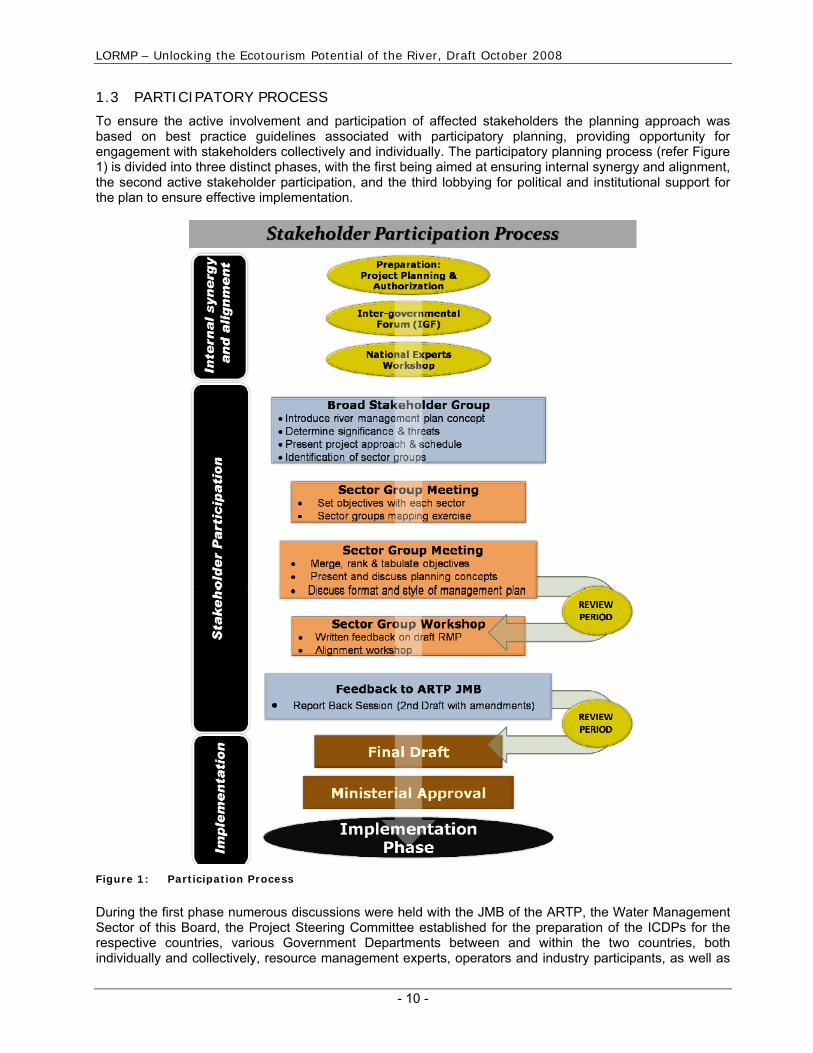
To ensure the active involvement and participation of affected stakeholders the planning approach was based on best practice guidelines associated with participatory planning, providing opportunity for engagement with stakeholders collectively and individually. The participatory planning process (refer Figure 1) is divided into three distinct phases, with the first being aimed at ensuring internal synergy and alignment, the second active stakeholder participation, and the third lobbying for political and institutional support for the plan to ensure effective implementation.
Figure 1: Participation Process
During the first phase numerous discussions were held with the JMB of the ARTP, the Water Management Sector of this Board, the Project Steering Committee established for the preparation of the ICDPs for the respective countries, various Government Departments between and within the two countries, both individually and collectively, resource management experts, operators and industry participants, as well as

LORMP – Unlocking the Ecotourism Potential of the River, Draft October 2008
- 11 -
traditional leadership structures, politicians and knowledgeable individuals. Baseline data was collected and collated for use within the participatory planning phase. The second phase was launched with a Broad Stakeholder Meeting in Kakamas, South Africa. Immediately it became evident that the large area covered by the scope of the project, linked to the level of poverty and immobility of key stakeholders, both within South Africa and Namibia, necessitated direct engagement of stakeholders, within specific sector groups. To enable this it was recommended that an Intergovernmental Forum be established in South Africa to facilitate the engagement of Government Departments at all three spheres of Government, that the intergovernmental relationship created by the Twinning Agreement between the Karas Region in Namibia and the Northern Cape Government in South Africa be utilized to discuss issues of transboundary significance, and that the JMB of the ARTP be used to discuss transfrontier conservation issues at a broader scale. The formalised whitewater rafting, kayaking and canoeing industry represented by the Africa Paddling Association (APA) was requested to incorporate non-affiliated operators in discussions to ensure that this industry speaks with one voice, rather than focusing on divisions as a result of affiliation. Several workshops, planning sessions and discussions were held with these operators regarding the planned interventions and potential solutions to unlocking the ecotourism potential of the river. During discussions with affected communities, it became evident that the historically disadvantaged communities were unwilling to discuss general aspects individually, and preferred to collectively discuss these matters, yet required assistance to attend meetings. Several meetings were held at Richtersveld, Riemvasmaak, Witbank, Noordoewer, Pella, Onseepkans, Warmbad, and Augrabies, while several other meetings pertaining to the ICDPs were held in the region as well (refer Figure 2).
Figure 2: Participation Process

LORMP – Unlocking the Ecotourism Potential of the River, Draft October 2008
Emanating from these interactions with stakeholders valuable insight into the specific problems, nuances, challenges, regional potential, trends, norms and standards have been garnered, and this plan reflects the needs and expectations of stakeholders, effectively giving a collective voice to these communities of interest, often marginalized due to racial discrimination in the past, or due to the low profile that the rafting, canoeing and kayaking industry has as an economic alternative. During the final stage the LORMP will be circulated to all stakeholders, individual and collective discussions held, and the inputs aligned, both regarding the use of the river, and the broader conservation objectives for the TFCA target area. Following this the draft plan will be workshopped collectively, after which the plan will be presented to the ARTP JMB. Following approval by the JMB, the LORMP will be submitted to the relevant ministries within either country. It is envisaged that the final plan will also be submitted to the Permanent Water Commission (PWC) between South Africa and Namibia for approval and implementation as a planned measure according to the guidelines of the SADC Protocol on Shared Water Courses. Undertaken in this way it is believed that both the objectives of the TFCA as well as those regarding the unlocking of the ecotourism potential of the river can be met in an equitable and sustainable manner. This approach represents one of southern Africa’s first integrated and aligned approaches to resource planning and conservation, aimed specifically at redressing inequities of the past, yet remaining environmentally and economically accountable.
- 12 -