Embed Size (px)
Citation preview
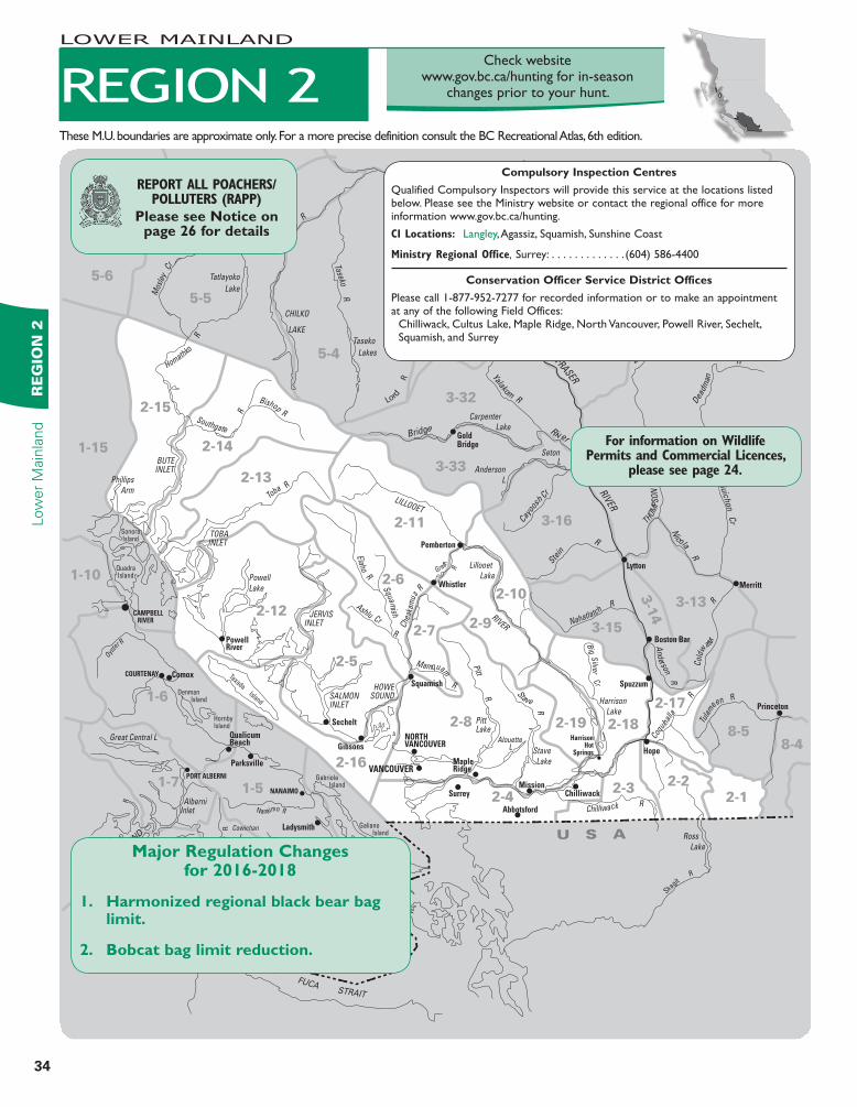
34
Low
er
Main
land
RE
GIO
N 2
Check website www.gov.bc.ca/hunting for in-season
changes prior to your hunt.
5-3
5-4
5-5
5-6
1-41-3
1-51-7
1-6
1-10
1-15
1-2
1-1
8-58-4
3-31
3-17
3-16
3-33
3-32
3-13
3-1
4
3-15
VICTORIA
Sidney
Duncan
Port Renfrew
JordanRiver
Bamfield
Ladysmith
NANAIMO
PORT ALBERNI
COURTENAY
CAMPBELL RIVER
Comox
Parksville
Squamish
Pemberton
Whistler
Surrey
Abbotsford
Mission
Hope
Princeton
Boston Bar
Spuzzum
Lytton
Merritt
Lillooet
GoldBridge
100 Mile House
Cache Creek
KAMLOOPS
Chilliwack
HarrisonHot
SpringsGibsons
Sechelt
QualicumBeach
PowellRiver
VANCOUVER
NORTHVANCOUVER
MapleRidge
Sooke
STRAIT
JUAN
DE
FUCA
BARKLE
Y S
OU
ND
Great Central L
Phillips
Arm
Powell
Lake
Mahood L
Canim
L
Carpenter
Lake
Lillooet
Lake
Harrison
Lake
Stave
Lake
Alouette L
PittLake
Ross
Lake
Bonaparte
L
Kamloops
Lake
Anderson
L
Seton L
AlberniInlet
Gabriola Island
Denman Island
QuadraIsland
SonoraIsland
HornbyIsland
Texada Island
Galiano Island
Saltspring Island
NitinatL
Taseko
Lakes
Tatlayoko
Lake
Cowichan
L
HOWESOUND
JERVISINLET
SALMONINLET
TOBAINLET
BUTEINLET
CHILKO
LAKE
San Juan R
Gor
don R
Nanaimo R
Niti
na
t
R
Leech R
Jo
rd
a n R
Muir C
r
R
Chemainus R
Oyste
r R
Klinakli
ni R
Homathko
R
Mos
ley
Cr
Chilk
o R
Taseko R
Bishop R
Toba R
Southgate
R
Big
C
r
Squa mish
R
Elaho R
Ashlu Cr
LILLOOET
RIVER
Cowichan R
Chilcotin River
Chur
n
Cr
Dog Cr
FRASER
RIVER
Bridge River
Yalakom R
Cayoo
sh C
r Ste
in
R
Nicola R
Gu
ich
on
Cr
Bonaparte
R
Dea
dma
n
R
Nahatlatch R
Col
dw
ater
R
Stave R
Pitt R
Anderson R
Coqu
ihal
la
R
Skagit
R
Big S
ilver Cr
Mamquam
R
Chea
kam
us R
Green
R
THO
MP
SO
N
R
Tula
mee
n R
U S A
Chilliwack R
Lord
R
2-1
2-22-3
2-4
2-8
2-5
2-72-9
2-6
2-19
2-16
2-10
2-12
2-11
2-13
2-14
2-15
2-18
2-17
Compulsory Inspection Centres
Qualified Compulsory Inspectors will provide this service at the locations listed below. Please see the Ministry website or contact the regional office for more information www.gov.bc.ca/hunting.
CI Locations: Langley, Agassiz, Squamish, Sunshine Coast
Ministry Regional Office, Surrey: . . . . . . . . . . . . . (604) 586-4400
Conservation Officer Service District Offices
Please call 1-877-952-7277 for recorded information or to make an appointment at any of the following Field Offices:
Chilliwack, Cultus Lake, Maple Ridge, North Vancouver, Powell River, Sechelt, Squamish, and Surrey
For information on Wildlife Permits and Commercial Licences,
please see page 24.
These M.U. boundaries are approximate only. For a more precise definition consult the BC Recreational Atlas, 6th edition.
REPORT ALL POACHERS/POLLUTERS (RAPP)
Please see Notice on page 26 for details
REGION 2
LOWER MAINLAND
Major Regulation Changes for 2016-2018
1. Harmonized regional black bear bag limit.
2. Bobcat bag limit reduction.
35
RE
GIO
N 2
Low
er M
ain
land
LOWER MAINLAND
REGIONAL BAG LIMITSBlack Bear: The regional bag limit for black bear is two. Deer: Unless otherwise indicated, the bag limit for mule (black-tailed) deer is two.Grouse: The daily aggregate bag limit for sooty/dusky (blue), spruce and ruffed grouse is ten.
NOTICE TO HUNTERS4No person shall use lead shot for any purpose when discharging a firearm on any dyke or on the water side (seaward or river side) of any dyke in the municipality of Delta, or on any foreshore dyke facing Mud Bay in the city of Surrey.4Fraser Valley Special Area - Hunters should take note of the special licence area in the Fraser Valley (see Map B10). These special licences are available through selected private outlets. For further information, contact a Service BC’s office.4No Shooting Areas or No Hunting Areas: Hunters should be aware of these areas as outlined on page 13 and regional maps.4Burns Bog (MU 2-4) No Hunting or Trapping Area - no hunting or trapping in the Burns Bog Partnership Lands.4Bowen Island No Shooting Area (MU 2-16) - contact the Bowen Island Municipal Clerk (604-947-4255) for important information on munici-pal bylaws (including those for use of bows) that also cover this area.4Vancouver Harbour: The discharge of firearms is prohibited in Burrard Inlet east of a straight line drawn from Point Grey to Point Atkinson (Lighthouse Park).4A small population of white-tailed deer has become resident to the Herrling Island area (MU 2-3) near Hope, BC. Hunters are reminded that there is no open season for white-tailed deer in this area.
4Boundary Bay Wildlife Management Area (MU 2-4) is closed to snipe hunting. This includes all foreshore areas seaward of the dykes surround-ing Boundary, Mud and Semiahmoo Bays. 4Whistler Olympic Park No Hunting Area. Hunting is prohibited within the boundaries of Whister Olympic Park.
ACCESS RESTRICTIONS4Information signs are posted or gates are placed at the points for motor vehicle closures. These signs are for the benefit of hunters, but it is the hunters’ responsibility to recognize closures whether a sign is in place or not. Contact local Ministry offices for details.4Motor Vehicle Closed Areas: see the definition of “Motor Vehicle” in the definitions section.H Motor Vehicle Closed Areas: The oper-ation of all motor vehicles is prohibited in these areas from April 1 to June 15, unless otherwise indicated.
MU 2-4
HBert Brink Wildlife Management Area - effec-tive year round.
MU 2-6
H beyond the bridge crossing at 50.5 mile of the Elaho G-Main Forest Service Road (FSR). H beyond the bridge crossing over Pikett Creek located at 30 mile on the Ashlu Creek North FSR.
MU 2-8H Pitt Addington Marsh - effective year round
MU 2-9Hbeyond the bridge crossing over an unnamed creek located 5 km north of the bridge crossing over North Sloquet Creek on the North Sloquet Creek FSR.
MU 2-11H beyond the first bridge crossing over South Creek on the South Creek FSRH on the Salal Creek FSR beyond 3 km North of the junction of the Upper Lillooet North FSR and the Salal Creek FSRH in the Phelix Creek FSR beyond the junction of Phelix Creek FSR and the Blackwater Creek FSRH beyond the bridge crossing over Delilah Creek on the North Creek FSRH beyond the bridge crossing over Hotsprings Creek on the Meager Creek South FSRH beyond the gate located at 9 km on the Meager Creek North FSRH beyond the bridge crossing over Tenquille Creek on the Birkenhead FSRH Prohibited year round beyond the bridge crossing over the Ryan River located 8 km on the Ryan River FSR
BC PARKS4Please refer to Site & Access Restrictions section for more information.4Hunting is prohibited in some BC Parks (Parks, Protected Areas, Recreation Areas, and Conservancies) and is permitted in others during an open season and within specific time periods. Hunting is prohibited in Ecological Reserves. Before hunting in a BC Park, hunters must verify that hunting in that area during that time is permitted. For more information on hunting regulations within BC Parks please phone your regional Ministry office or visit the Fish and Wildlife Branch website at www.gov.bc.ca/hunting.
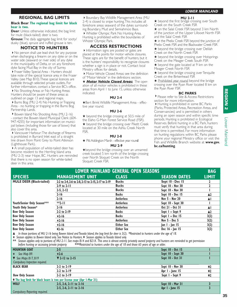
LOWER MAINLAND GENERAL OPEN SEASONS BAGSPECIES MANAGEMENT UNIT CLASS SEASON DATES LIMITMULE DEER (Black-tailed) 2-2 to 2-4, 2-6 to 2-8, 2-13 to 2-15, 2-17 to 2-19 Bucks Sept 10 - Dec 15 2
2-9 to 2-11 Bucks Sept 10 - Nov 30 2
2-5, 2-12 Bucks Sept 10 - Nov 30 1
2-16 Bucks Sept 10 - Dec 15 s22-16 Antlerless Nov 5 - Nov 20 s1
Youth/Senior Only Season*** **2-11 Antlerless Sept 10 - Sept 30 1
Youth Only Season* 2-16 Antlerless Oct 21 - Oct 31 s1Bow Only Season 2-2 to 2-19 Bucks Sept 1 – Sept 9 s2Bow Only Season H2-16 Bucks Sept 1 – Dec 15 3(2)
Bow Only Season H2-16 Antlerless Nov 5 - Dec 5 3(2)
Bow Only Season H2-16 Either Sex Jan 1 - Jan 15 3(2)Bow Only Season ©2-16 Either Sex Dec 16 - Jan 15 3(2)
s In those portions of MU 2-16 being Bowen Island and Texada Island, the bag limit for deer is 3(2). *Restricted to hunters under the age of 18.H Season applies to Bowen Island only. See Notice to Hunters. © Season applies to Texada Island only.** Season applies only to portions of MU 2-11. See maps B14 and B21A. This area is almost entirely privately owned property and hunters are reminded to get permission
before hunting or accessing private property ***Restricted to hunters under the age of 18 and those 65 years of age or older.
MOUNTAIN GOAT 2-5 Sept 10 - Oct 15 1
H See Map B9. H2-6 Sept 10 - Sept 30 1
t See Maps B17, B19 t 2-12 to 2-15 Sept 10 - Oct 31 1Compulsory Inspection required.
BLACK BEAR 2-2 to 2-19 Sept 10 - Nov 30 Q22-2 to 2-19 Apr 1 - June 15 Q2
Bow Only Season 2-2 to 2-19 Sept 1 - Sept 9 Q2
Q The bag limit for black bears is two per license year (Apr 1-Mar 31)WOLF 2-5, 2-6, 2-11 to 2-16 Sept 10 - Mar 31 3
2-5, 2-6, 2-11 to 2-16 Apr 1 - June 15 3Compulsory Reporting required.
36
Low
er
Main
land
RE
GIO
N 2
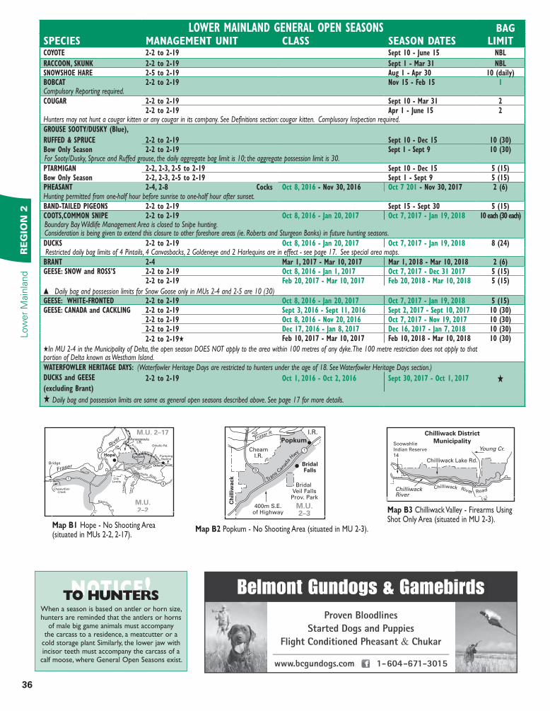
LOWER MAINLAND GENERAL OPEN SEASONS BAGSPECIES MANAGEMENT UNIT CLASS SEASON DATES LIMITCOYOTE 2-2 to 2-19 Sept 10 - June 15 NBL
RACCOON, SKUNK 2-2 to 2-19 Sept 1 - Mar 31 NBLSNOWSHOE HARE 2-5 to 2-19 Aug 1 - Apr 30 10 (daily)BOBCAT 2-2 to 2-19 Nov 15 - Feb 15 1Compulsory Reporting required.COUGAR 2-2 to 2-19 Sept 10 - Mar 31 2
2-2 to 2-19 Apr 1 - June 15 2Hunters may not hunt a cougar kitten or any cougar in its company. See Definitions section: cougar kitten. Complusory Inspection required.GROUSE SOOTY/DUSKY (Blue),
RUFFED & SPRUCE 2-2 to 2-19 Sept 10 - Dec 15 10 (30)Bow Only Season 2-2 to 2-19 Sept 1 - Sept 9 10 (30)For Sooty/Dusky, Spruce and Ruffed grouse, the daily aggregate bag limit is 10; the aggregate possession limit is 30.PTARMIGAN 2-2, 2-3, 2-5 to 2-19 Sept 10 - Dec 15 5 (15)Bow Only Season 2-2, 2-3, 2-5 to 2-19 Sept 1 - Sept 9 5 (15)PHEASANT 2-4, 2-8 Cocks Oct 8, 2016 - Nov 30, 2016 Oct 7 201 - Nov 30, 2017 2 (6)Hunting permitted from one-half hour before sunrise to one-half hour after sunset.BAND-TAILED PIGEONS 2-2 to 2-19 Sept 15 - Sept 30 5 (15)COOTS,COMMON SNIPE 2-2 to 2-19 Oct 8, 2016 - Jan 20, 2017 Oct 7, 2017 - Jan 19, 2018 10 each (30 each)Boundary Bay Wildlife Management Area is closed to Snipe hunting. Consideration is being given to extend this closure to other foreshore areas (ie. Roberts and Sturgeon Banks) in future hunting seasons.DUCKS 2-2 to 2-19 Oct 8, 2016 - Jan 20, 2017 Oct 7, 2017 - Jan 19, 2018 8 (24)Restricted daily bag limits of 4 Pintails, 4 Canvasbacks, 2 Goldeneye and 2 Harlequins are in effect - see page 17. See special area maps. BRANT 2-4 Mar 1, 2017 - Mar 10, 2017 Mar 1, 2018 - Mar 10, 2018 2 (6)GEESE: SNOW and ROSS’S 2-2 to 2-19 Oct 8, 2016 - Jan 1, 2017 Oct 7, 2017 - Dec 31 2017 5 (15)
2-2 to 2-19 Feb 20, 2017 - Mar 10, 2017 Feb 20, 2018 - Mar 10, 2018 5 (15)
s Daily bag and possession limits for Snow Goose only in MUs 2-4 and 2-5 are 10 (30)GEESE: WHITE-FRONTED 2-2 to 2-19 Oct 8, 2016 - Jan 20, 2017 Oct 7, 2017 - Jan 19, 2018 5 (15)GEESE: CANADA and CACKLING 2-2 to 2-19 Sept 3, 2016 - Sept 11, 2016 Sept 2, 2017 - Sept 10, 2017 10 (30)
2-2 to 2-19 Oct 8, 2016 - Nov 20, 2016 Oct 7, 2017 - Nov 19, 2017 10 (30)2-2 to 2-19 Dec 17, 2016 - Jan 8, 2017 Dec 16, 2017 - Jan 7, 2018 10 (30)
2-2 to 2-19H Feb 10, 2017 - Mar 10, 2017 Feb 10, 2018 - Mar 10, 2018 10 (30)
HIn MU 2-4 in the Municipality of Delta, the open season DOES NOT apply to the area within 100 metres of any dyke. The 100 metre restriction does not apply to that portion of Delta known as Westham Island.WATERFOWLER HERITAGE DAYS: (Waterfowler Heritage Days are restricted to hunters under the age of 18. See Waterfowler Heritage Days section.)DUCKS and GEESE
(excluding Brant)
2-2 to 2-19 Oct 1, 2016 - Oct 2, 2016 Sept 30, 2017 - Oct 1, 2017 H
H Daily bag and possession limits are same as general open seasons described above. See page 17 for more details.
NOTICE!TO HUNTERSWhen a season is based on antler or horn size, hunters are reminded that the antlers or horns
of male big game animals must accompany the carcass to a residence, a meatcutter or a
cold storage plant Similarly, the lower jaw with incisor teeth must accompany the carcass of a calf moose, where General Open Seasons exist.
Belmont Gundogs & Gamebirds
Proven Bloodlines
Started Dogs and Puppies
Flight Conditioned Pheasant & Chukar
www.bcgundogs.com • 1-604-671-3015
Fraser
River
1
1
3
AywawwisI.R.
Hope
Private
Logging Road
OthelloGas Pipeline
KawkawaL.
ChawuthenCreek
Siverhope Cr.
ka C
r.
Coquihalla River
Th
acker
Cr.
Tw
o M
ile C
r.
PumpingStation
Bridge
M.U. 2–17
M.U.2–2
City Limits
Othello Rd. Soowahlie
Indian Reserve
14Chilliwack Lake Rd.
ChilliwackRiver
Chilliwack District
MunicipalityYoung Cr.
Tam
ihi C
r
Chilliwack River Road
BridalFalls
Ch
illi
wa
ck
CheamI.R.
400m S.E.of Highway
Bridal Veil Falls
Prov. Park
Popkum
I.R.Fraser R.
Trans
Canad
a
Hw
y
M.U.2–3
9
1
Map B1 Hope - No Shooting Area (situated in MUs 2-2, 2-17).
Map B3 Chilliwack Valley - Firearms Using Shot Only Area (situated in MU 2-3).
Map B2 Popkum - No Shooting Area (situated in MU 2-3).
37
RE
GIO
N 2
Low
er M
ain
land
LOWER MAINLAND
www. .com
GUNSMITHING
Barry Jensen (604) 946-6168
JENCON
Salinaw
Lak
e
101
HotelL.
Garden BayL.
Mixal L.
Pender Harbour
Irvin
es L
andin
g
Garden Bay Rd.
Garden Bay
Daniel
Pt.LeeBay
Cecil Hill 500m east
of power line
Meyers Cr.
Francis Pt.
Martin
Is.
B.C
. Hyd
ro
NO SHOOTING AREA
FIREARMS USING SHOT ONLY AREA
500m
offshore boundary
M.U. 2-5
mean low
water mark
Kleindale
IrvinesLanding
Madeira Park
Haslam Cr.
Nelson IslandSutton
Islets
Boom
Isles
North
Lake
Ruby Lake
Waugh
Lake
Brown
Lake
EgmontEarls Cove
Agamemnon Channel Skookumchuck
Narrows
101
B.C. Hydro R/W
Nile Pt.
M.U. 2-5
Squamish
PembertonHeightof Land
Heightof Land
Squam
ish R
.
Cheaka
mus
R.
Lillooet R
.
Soo R.
Ashlu Cr.
Ryan R.
Elah
o R
.M.U. 2–6
CheakamusI.R. 11
Levette Lake
Evans Lake
Evan
s Cr.
Squamish
Dis
t. M
un.
M.U.2–6
Chilliwack
Mission
Maple Ridge
Richmond
Coquitlam
Pitt
Meadows
City of
Abbotsford
LangleyDeltaU.S.A.
Includes Foreshore areas
Surrey
M.U. 2–8
M.U. 2–3
M.U.2–4
Pitt Lake
Stave Lake
Harrison
Lake
Map B10 Fraser Valley Special Licence Hunting Area (FVSLHA) (situated in MUs 2-4, 2-8). All persons hunting within MU 2-4 & those portions of MU 2-8 within the corporate limits of the corporation of the district of Maple Ridge, the corporation of the district of Pitt Meadows, the district of Mission, the corporation of the district of Coquitlam are required to purchase a Fraser Valley Special Area Hunting Licence in addition to other Provincial licences and for hunting migratory game birds, the Migratory Bird Licence. $1,000,000.00 Public Liability and Property Damage insurance is required.
0.8km either side of road
ChilliwackLake
U.S.A.
ProvincialJail ServiceCamp
Chilliwack
River
Slesse C
r.
M.U. 2–3
Map B4 Provincial Jail Camp No. 1 No Shooting Area (situated in MU 2-3).
Map B5 Pender Harbour - No Shooting Area and Firearms Using Shot Only Area (situated in MU 2-5).
Sech
elt In
let
Haslam Cr.
Halfmoon BayR
ain
y R
.
Gibsons
B.C. Hydro R/W
NO SHOOTING AREA
FIREARMS USING SHOT ONLY AREA
M.U. 2-5
LangdaleCr.
Chapman C
r.
TrailBay
500m
500m northof Hwy 101
500m offshore boundary
Eas
t W
ilson C
r.Rober
ts C
r.
Irvin
e Cr.
Snake
Bay
101
101
Hal
fmoon C
r.
PortMellon
Sechelt
Map B7 Sechelt/Gibsons - No Shooting Area and Firearms Using Shot Only Area (situated in MU 2-5).
Map B8 Waugh Lake/Skookumchuck - No Shooting Area (situated in MU 2-5).
Map B9 Ashlu - Squamish Rivers Mountain Goat Closed Area (situated in MU 2-6).
Map B6 Evans Lake - No Shooting Area (situated in MU 2-6).
BuntzenLake
North
Vancouver
Municipality
Mun.Bdry.
Port Moody
Ioco
India
n A
rm
M.U.2–8
M.U.2–8
Gonzales Cr.
Shannon Cr.
Sta
wamus River
400m contour
SquamishMun. Bdry. co
ntour
600m
Squamish99
Map B11 Buntzen Lake - No Shooting Area (situated in MU 2-8).
Map B12 Squamish - No Shooting Area (situated in MU 2-8).
LionsBay
Ho
we
So
un
d
Height of Land
Height of Land
TheLions
Mt.Harvey
Magnesia Cr.
Lone Tree Cr.
Harvey Cr.
M.U.2–899
Map B13 Lion’s Bay - No Shooting Area (situated in MU 2-8).
M.U.2–9
M.U.2–11
M.U.2–10
350 metre Contour
Nairn FallsProv. Park
350 metre Contour
450 metre Contour
450 metre Contour
I.R.6
I.R.8I.R.1
I.R.10
B.C.R.
Gra
ve l l C
ree
k
Pemberton
L i l loo
et R ive r
Ryan R.
Miller Cr.
Pemberton Cr.
Map B14 Pemberton - Firearms Using Shot Only Area (situated in MUs 2-9, 2-10, 2-11).
38
RESOURCE MANAGEMENT REGION 2Low
er
Main
land
RE
GIO
N 2
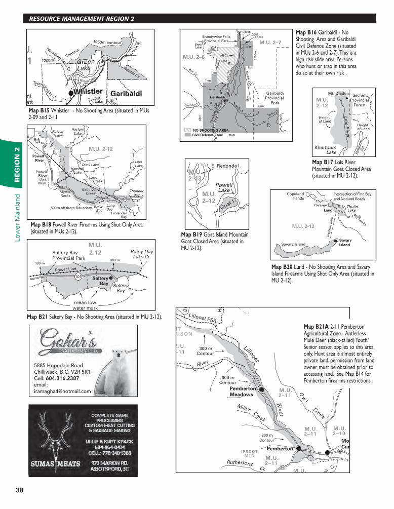
Map B15 Whistler - No Shooting Area (situated in MUs 2-09 and 2-11
Brandywine Falls
Provincial Park
Garibaldi
Provincial
Park
L4098L3558
L4100
350m
L6902
1km
1km
1km
Garibaldi
9km
4km
5km
3km
2km
3150m
6km
L4101
Roe Cr.
Chance Cr.
Taylor Cr.
Marb
le C
r.
Dais
y L
ake
Rubble C
r.
M.U. 2–6
M.U. 2–7
Ch
eaka
mus
Riv
er
99
BrewLake
900m
cont
our
NO SHOOTING AREA
Civil Defence Zone
Map B16 Garibaldi - No Shooting Area and Garibaldi Civil Defence Zone (situated in MUs 2-6 and 2-7). This is a high risk slide area. Persons who hunt or trap in this area do so at their own risk .
KhartoumLake H
oth
am
Sd
.
Lo
is R
iver
Mt. Diadem Sechelt
Provincial
Forest
Heightof Land
Heightof Land
M.U.2–12
Map B17 Lois River Mountain Goat Closed Area (situated in MU 2-12).
E. Redonda I.
PowellLake
Goat I.
M.U.2–13
M.U.2–12
Map B19 Goat Island Mountain Goat Closed Area (situated in MU 2-12).
M.U. 2-12
Savary IslandSavary
Island
Thulin Lake
Copeland
Islands
101
Lund
Tele
phone C
able
intersection of Finn Bay
and Norlund RoadsThulin
Passage
Saltery Bay
Provincial Park
Power Line
SalteryBay
Rainy DayLake Cr.
mean low
water mark
101
M.U.
2-12
SalteryBay
300 m300 m
Map B20 Lund - No Shooting Area and Savary Island Firearms Using Shot Only Area (situated in MU 2-12).
Map B21 Saltery Bay - No Shooting Area (situated in MU 2-12).
M.U. 2-12
Lois
LakeHammil Lake
Duck Lake
FrolanderBay
LangBay
Lang Creek
Kelly Creek
BrewBay
MyrtleRocks
PowellRiverDist.
Mun.
Thunder
Bay
Haslam
LakePowell
Lake
500m offshore Boundary
Powell
River
101
101
Map B18 Powell River Firearms Using Shot Only Area (situated in MUs 2-12).
Bu
Pemberton
Pemberton
Meadows
99
99
River
Miller Creek
Lillooet R
iver
O w
l Cree
k
IPSOOT
MTN
M.U.
2–11
M.U.
2–11
MT
MORRISON
Mount
Currie
vell C
r
300 mContour
Hu
rley F
SR
Lillooet FSR
Rutherford Cr.
300 mContour
300 m
Contour
M.U.
2–11
M.U.
2–11
M.U.
M.U.
2–10
Map B21A 2-11 Pemberton Agricultural Zone - Antlerless Mule Deer (black-tailed) Youth/Senior season applies to this area only. Hunt area is almost entirely private land, permission from land owner must be obtained prior to accessing land. See Map B14 for Pemberton firearms restrictions.
Green Lake
Lost Lake
Nineteen Mile C
r.
Twenty Mile Cr.
Blackco
Rethel Cr.
GreenLake
GaribaldiMount
Sproatt
G
reen
R. 1050m contour
M.U.
2–11
WhistlerWhistler
1200m C
ontour
5885 Hopedale RoadChilliwack, B.C. V2R 5R1Cell: 604.316.2387email:[email protected]
39
LOWER MAINLANDR
EG
ION
2Low
er M
ain
land
For all your ATV/UTV tires,
wheels and accessories
103 - 13177 76th Avenue, Surrey, BC 604-543-7744 • 800-661-6600
www.Casterland.com
Service and Selection since 1975
Gibsons
Keats I. BowenIsland
HoweSound
Strait ofGeorgia
M.U.2–16
M.U.2–5
M.U. 2-16
Strait of G
eorgia 200 m
200 m
200 m
200 m
Gillies
Bay
Gillies
Bay
Cranby Cr.
Shelter
Pt. Rd.Dick
Island
Harwood Pt.
mean low
water mark
water
tower
Gillie
s B
ay H
wy.
TEXADA
ISLAND
700 m
B.C
. H
ydro
R/W
FraserRiver
Yale
Gordon Cr.
Mary
An
n C
r.
M.U.2–18
1
C.N.R
C.P.R
CanadianForest ProductsChehalislogging Road
0.8km (0.5mi.)either sideof the road
Elbow Lake
Institution
Sign
Sign
Chehalis
River
Elbow
Lake
I.R.
Pretty C
r.
M.U.2–19
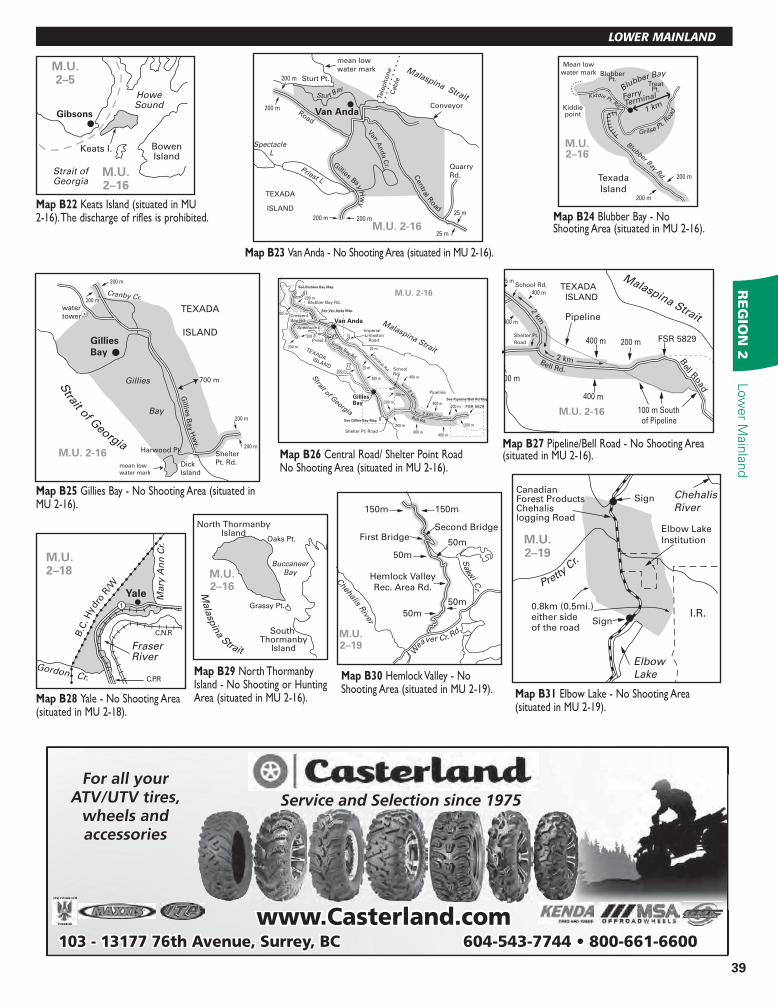
Map B22 Keats Island (situated in MU 2-16). The discharge of rifles is prohibited.
Mean low
water mark BlubberPt.
TreatPt.
Kiddiepoint
Blubber Bay
Texada
Island
Blubber Bay Rd.
Grilse Pt.
Road
Kiddie Pt. Rd.
M.U.2–16
200 m
200 m
Ferry
Terminal
1 km
Map B24 Blubber Bay - No Shooting Area (situated in MU 2-16).M.U. 2-16
Sturt Pt.
Priest L
ConveyorVan Anda
Sturt Bay
Van And
a C
r.
Centra
l Road
Gillies Bay
Hw
y
Road
mean low
water mark Malaspina Strait
TEXADA
ISLAND
Quarry
Rd.
Spectacle
L
Tele
ph
on
e
Cab
le
25 m
25 m
200 m200 m
200 m
200 m
Map B23 Van Anda - No Shooting Area (situated in MU 2-16).
Map B25 Gillies Bay - No Shooting Area (situated in MU 2-16).
Map B28 Yale - No Shooting Area (situated in MU 2-18).
South Thormanby
Island
North ThormanbyIsland
BuccaneerBay
Grassy Pt.
Oaks Pt.
M.U.2–16M
ala
spin
a Strait
Map B29 North Thormanby Island - No Shooting or Hunting Area (situated in MU 2-16).
Shelter Pt. Road
Bell Rd.
Van Anda
GilliesBay
TEXADA Central R
d.
Gillies Bay Rd.
400 m
400 m
400 m
400 m
25 m
25 m2 km
2 km
M.U. 2-16
See Gillies Bay Map
See Van Anda Map
See Blubber Bay Map
200 m
200 m
200 m
200 m
200 m
200 m
200 m
200 m
Malaspina Strait
Strait of G
eorgia
ISLAND
Priest L
Spectacle L
School Rd.
Imperial Limeston Road
Blubber Bay Rd.
Crescent Bay Rd.
See Pipeline/Bell Rd Map
FSR 5829
Pipeline
200 m
200 m
400 m
Map B26 Central Road/ Shelter Point Road No Shooting Area (situated in MU 2-16).
Hemlock Valley
Rec. Area Rd.
150m 150m
First BridgeSecond Bridge
50m
50m
50m
50m
Chehalis R
iver
Sakw
i Cr.
Wea
ver Cr. Rd.
M.U.2–19
Map B30 Hemlock Valley - No Shooting Area (situated in MU 2-19). Map B31 Elbow Lake - No Shooting Area
(situated in MU 2-19).
25 mSchool Rd.
2 km
400 m
400 m
Shelter Pt.
Road
Bell R
oad
Bell Rd.
400 m
400 m
2 km
M.U. 2-16
Malaspina Strait
FSR 5829
Pipeline
200 m
100 m South
of Pipeline
200 m
TEXADA
ISLAND
Map B27 Pipeline/Bell Road - No Shooting Area (situated in MU 2-16).
40
NOTICE!TO HUNTERS
In-season regulation changes are posted on the Fish and Wildlife websiteRegulations are subject to change from time to time, and it is the hunter’s
responsibility to be informed of current regulations. Please check our website for in-season changes before your hunt: www.env.gov.bc.ca/fw/hunting/news
Or subscribe to RSS a new internet-based service that allows users to sign up for instant web updates. See page 2 for details.
We want to be a part of
your hunting world!
STILLWATER SPORTS4849 DELTA ST., DELTA, BC V4K 2T9
604•946•9933
FOR GREAT PRICES CALL:
Hunting
Equipment,
Archery,
Guns,
Ammo &
more!
Independently Owned and Operated 6337 198th Street, Langley, BC V2Y 2E3
TREELAND REALTY
CLOVERDALE,B.C.
[email protected] www.Tony-Z.com
PERSONAL REAL ESTATE CORPORATION
Call Manny • 604 460-6411 17935 Ford Detour Rd. Pitt Meadows
604 460-6411 • 17935 Ford Detour Rd. Pitt Meadows
• GAME CUTTING
Country Meadow Meats Serving the lower mainland
• G CUTTING • C CUTTING • H G
Sergiy YakovenkoCertiied Instructor/ExaminerRestricted and Non-Restricted
Firearms SafetyHunter Safety Courses (CORE)
Tel/Fax 604-502-0986
[email protected] Cell 778-994-9993
www.antlersandhoofs.com
Email: [email protected]
&MM TEUROPEANMOUNTS
Preserve Your Trophy!
Call Shane: 604-997-4367
41
AFTER YOUR HUNT
Interested in advertising in the BC Freshwater Fishing Regulations & BC Hunting Regulations
Phone 250-480-3244 or E-mail: [email protected].
604 796 0006
WWW.KENTOUTDOORS.CA
7048 PIONEER AVE, AGASSIZ, BC
Your Fishing and Hunting
Headquarters in the Fraser Valley…• Over 250 Firearms in Stock
• Great Prices! Best Selection!
• We are an Exclusive PSE & Bowtech dealer.
• Zeiss, Leupold, & Vortex dealer.
Visit us on the web:www.chilliwackdart.com
(604) 793-99222 - 9120 Young Rd.
Chilliwack
Dart & Tackle
Horn Curl EducationThe Wild Sheep Society of British Columbia (WSSBC) has partnered with the British Columbia
Ministry of Forests, Lands, and Natural Resources Operations (FLNRO) to develop a Sheep Horn Curl Education Program for hunters to ensure harvested wild sheep are of legal size. The WSSBC and FLNRO are concerned about the increase in illegal sheep killed in British Columbia, in some cases as a result of poor age or horn length estimation. Illegal kills may threaten individual herds or populations and result in hunting restrictions in specific areas.
Recognizing the need to limit the illegal sheep harvest in British Columbia, the WSSBC with the support of FLNRO, created a Sheep Horn Curl Education Program. The program is divided into two sections: an informational component, and a test component. All sheep hunters should review the Sheep Horn Curl Education Program and take the horn curl test. Even experienced sheep hunters will find it a helpful review. Please go to http://wild-sheepsociety.homestead.com/HornCurlTest.
html, click on the Education Page button, review the Sheep Horn Curl Education information and take the Horn Curl Test.
Wild and Domestic Sheep ContactWild sheep herds can suffer catastrophic die-offs, compounded by slow recovery periods from respiratory disease (pneumonia) transmitted from domestic sheep and goats. There are no treatments or preventative measures other than physical separation. With funding from the Habitat conservation Trust Fund, ArdCorp, and the Wild Sheep Society of BC, The BC Sheep Separation Program is working with domestic sheep farmers in high-risk areas in the Kootenay, Okanagan and Thompson Regions to reduce the risk of contact between domestic and wild sheep.
To report any interactions between wild sheep and domestic sheep or goats call the
RAPP Line 1-877-952-7277.
For more information on the BC Sheep Separation Program, contact Program Coordinator Jeremy Ayotte on 250-804-3513 or e-mail [email protected]. Good luck and happy hunting!
THE WILD SHEEP SOCIETY OF BRITISH COLUMBIAP
HO
TO: L
INO G
RIF
ON
E
Contact Al Frank
(604) [email protected]
Specialized in raising
high quality pheasants!
Email: [email protected]
&MM TEUROPEANMOUNTS
Preserve Your Trophy!
Call Shane: 604-997-4367
Monster Buck Taxidermy & School
Agassiz, B.C.
Interestedin buying• antlers• capes• skins
Our Specialty• mount your own buck• lifesize• head mounts
Stan604-771-8769
Don604-217-1606