Embed Size (px)
Citation preview
LOWER KASILOF RIVER BOAT LAUNCH SITE INVESTIGATIONS
Final Report
Prepared for: Alaska Department of Natural Resources
Division of Parks and Outdoor Recreation 550 W. 7th Ave. Ste 1340
Anchorage, AK 99501
Prepared by:
HDR Alaska, Inc. 2525 C Street, Suite 305
Anchorage, Alaska 99503
October 2008

Lower Kasilof River Boat Launch Site Investigations
Final Report i October 2008
Table of Contents
Section Page
1.0 Executive Summary .............................................................................................................1
2.0 Project Authorization and Scope .........................................................................................2
3.0 Project Background..............................................................................................................2
4.0 Site Investigation .................................................................................................................3
4.1 Data Collection ...............................................................................................................3 4.2 Hydrologic Assessment ..................................................................................................6 4.3 Site Evaluation................................................................................................................7 4.4 North Site .......................................................................................................................7 4.5 South Site .....................................................................................................................11 4.6 Recommended Alternative............................................................................................17
5.0 Permitting...........................................................................................................................18
6.0 Public Involvement ............................................................................................................26
6.1 Public Involvement Plan ..............................................................................................26 6.2 Public Meetings ...........................................................................................................26 6.3 Correspondence............................................................................................................27
7.0 References..........................................................................................................................27
Lower Kasilof River Boat Launch Site Investigations
Final Report ii October 2008
Tables Page Table 4.1 Kasilof River, Monthly Mean Streamflow Statistics ........................................................ 6 Table 4.2 Estimated Tidal Datum for Kasilof River......................................................................... 6 Table 4.3 North Site Distances to Other Locations ........................................................................ 9 Table 4.4 Comparison of North and South Sites .......................................................................... 17 Table 5.1 Agencies Contacted for Permitting............................................................................... 19 Table 5.2 Summary of Agency Comments for Permitting ........................................................... 19 Figures Page Figure 4.1 Vicinity Map.................................................................................................................. 4 Figure 4.2 Study Site....................................................................................................................... 5 Figure 4.3 North Site....................................................................................................................... 8 Figure 4.4 South Site..................................................................................................................... 13 Appendices 1 Concept Drawings and Cost Estimates 2 Site Photos 3 River Migration Analysis 4 Soils Mapping and Wetland Report 5 Cultural Report 6 Agency Correspondence 7 Public Involvement 8 Preliminary Environmental Site Investigations Reports
Lower Kasilof River Boat Launch Site Investigations
Final Report 1 October 2008
1.0 Executive Summary
The Alaska Department of Natural Resources (ADNR), Division of Parks and Outdoor Recreation in cooperation with the Alaska Department of Fish and Game (ADF&G), Division of Sport Fish Access is considering a new public boat launch ramp on the lower Kasilof River. This report evaluates the suitability of two potential sites which were initially selected by ADNR. Currently, boaters access the Kasilof River at the existing Alaska State Parks public boat launch at the Sterling Highway; however, there is no publicly owned exit point for boaters on the lower Kasilof River. A public boat launch would provide access to sport fishermen to fish the lower Kasilof River. Two parcels of land were identified by ADNR for analysis as potential launch alternatives:
The North Site alternative (Kimbrough Parcel) is located at River Mile (RM) 4.1 and fronts on Williamson Lane.
The South Site alternative (Swanson Parcel) is located at RM 4.5 and fronts on Silver Fox Drive.
These sites were evaluated on the following: hydrologic issues; constructability; potential for site contamination; cultural resources; capitol and operations and maintenance (O&M) costs; and permit constraints. A concept-level site plan was developed for each site. This study also included public involvement which was a key component to this project. This analysis concluded that either site could meet the design criteria specified for this launch but neither site combines both the riverine and the upland components of the perfect boat launch site. The North Site is located where the river is a stable single channel but has a steep upland topography which requires a long ramp and a long steep walk from the vehicle parking area to the boat launch. The North Site is also located in a residential area and vehicle traffic to the launch would be routed through a residential neighborhood. There is no room for expansion of this site. The South Site is located on a split channel segment of the river. This segment has been stable for the past 45 years and it is very likely to remain so, but there is no guarantee that this stability will continue into the future. Because of the split channels there is a possibility that first time drift boat users may miss the channel that leads to the launch and have a difficult time making their way back upstream to the launch site. The advantages of the South Site are that the upland portion of the site is level and would provide easy access from the vehicle parking area to the boat launch; the access route to the site is along residential roads but there is presently no development in this area and because of the layout of these residential lots the effect of launch traffic on these future residents would be minimal; and that the South Site could easily accommodate future expansion of vehicle parking or even be developed as a camping or picnic area. The choice of which site is preferable will likely be made for other than technical reasons. For instance there may be strong public user preference for a certain site, a seller may not be willing when funding becomes available to purchase a particular site, or there may be a desire by ADNR for an expanded facility which only the South Site could provide.
Lower Kasilof River Boat Launch Site Investigations
Final Report 2 October 2008
2.0 Project Authorization and Scope
The ADNR, Division of Parks and Outdoor Recreation contracted with HDR Alaska, Inc. (HDR) under a professional service agreement to evaluate the suitability of two potential locations for a public boat launch on the lower Kasilof River. This study consisted of the following tasks:
Task 1: Site Investigation Hydrologic Assessment Parcel Investigation Permitting Issues Conceptual Site Plans Cost of Construction and Long-term Operations and Maintenance
Task 2: Public Involvement Public Involvement Plan Public Meetings
Task 3: Final Report
ADNR issued a notice to proceed to HDR for this work on March 24, 2008. This report completes task 3 of this project.
3.0 Project Background
The Kasilof River, located on the Kenai Peninsula, originates at the outlet of Tustumena Lake at River Mile (RM) 17.5, and flows northwest to Cook Inlet (RM 0). The Sterling Highway crosses at RM 7.8, Crooked Creek flows into the Kasilof River at RM 6.8, and Coal Creek flows into the Kasilof River at RM 4.3. Four species of salmon are present in this drainage including chinook, coho, sockeye, and pink salmon. Additionally, anadromous and resident rainbow/steelhead trout, anadromous and resident Dolly Varden, and resident lake trout are present (ADF&G 2008a). The Kasilof River is part of the North Kenai Peninsula Management Area (NKPMA) (ADF&G 2008b). Although sports fisheries in the Kasilof River exist for all species listed previously, efforts are directed primarily toward the Chinook salmon fishery, (ADF&G 2008a). The Chinook fishery is primarily a drift boat fishery. There is also personal use dip net and personal use set gillnet fisheries at the mouth of the Kasilof River for salmon (all species except Chinook) and flounder. Permit holders are allowed to keep 10 flounder. Though no Chinook/kings can be retained in the dip-net Personal Use (PU) fishery, the Kasilof set gillnet PU fishery does allow retention of all kings caught (ADF&G 2008c).
The Kasilof River is accessed by boaters at the public boat launch at the Sterling Highway, which was reconstructed in 2004. Currently, there is no publicly owned exit point for boaters on the lower Kasilof River; however, two privately owned boat launches do exist. The Cohoe Cove Launch located at RM 6.0 and the Trujillo Launch site located at RM 4.0. In 2001, ADF&G became aware of the need for a public boat launch on the lower Kasilof; however, no funding was available. In 2008 limited funding was received for data collection and this site investigation study.
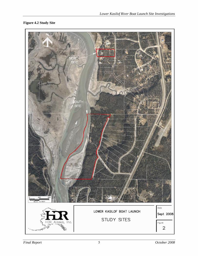
Two parcels of land (see figures 1 and 2) were identified by ADNR for investigation as potential launch sites:
Lower Kasilof River Boat Launch Site Investigations
Final Report 3 October 2008
The North Site alternative (Kimbrough Parcel) is located at RM 4.1 and fronts on Williamson Lane at T3N, R12W, Sec 12 in the Seward Meridian. The legal description of this property is Coal Creek Country Estates Subdivision, Addition No. 6, Tract A.
The South Site alternative (Swanson Parcel) is located at RM 4.5 and fronts on Silver Fox Drive at T3N, R12W, Sec 13 in the Seward Meridian. The legal description of this property is Government Lot 6 & 11 excluding Foxhills Estates Subdivision Part One.
The ADNR site selection was based on aerial photography to determine potential sites and a subsequent field evaluation of these sites. The site selection was limited to the reach of river between RM 4 and RM 5. Locations further upstream would limit the available fishing area and locations further downstream would be further into the tidal zone and would be difficult to access in a drift boat due to tidal action, slow water conditions, and wind. Initially, ADNR identified the Trujillo launch site at RM 4 as a potential site; however, as of May 21, 2008 the property was withdrawn from consideration by the owner. Subsequently, the parcel immediately upstream of the Trujillo launch site (Kimbrough Parcel) was identified as a potential site with a willing seller.
Site nomenclature for the remainder of this report will use the terms North Site and South Site for the two alternatives. As the Kasilof River generally flows to the north in this area, the North Site is downstream of the South Site. Descriptions of right or left are related to looking downstream. River Miles (RM) begin at the mouth of the river at 0 and are measured along the centerline of the main channel.
4.0 Site Investigation
4.1 Data Collection
Available information on the Kasilof River was collected and reviewed. This information included:
Aerial photos dated May 2, 1963 at a scale of 1”= 1,320’ Aerial photos dated May 25, 1982 at a scale of 1”=1,000’ Aerial photos dated May 14, 2001 at a scale of 1”=2,000’ USGS streamflow data, Kasilof River at Kasilof Kenai Peninsula Borough land status mapping USDA, NRCS, Soil Survey of Western Kenai Peninsula Area, Alaska
A detailed survey was completed at each of the potential parcels. The North Site was surveyed in early June 2008. The South Site was surveyed in early May 2008. During these surveys property boundaries were located and staked and a cross section of the river was completed at the launch site selected at each parcel. Survey drawings are included in Appendix 1.
A site reconnaissance was completed for each site. At that time road access was assessed; site boundaries were reviewed; hydrologic features, vegetation, and soils observed; and ground photos were taken. A launch site was selected at each parcel based upon site constraints.
A site reconnaissance for potential contamination was performed. Preliminary Environmental Site Investigations Reports are included in Appendix 8.


Lower Kasilof River Boat Launch Site Investigations
Final Report 4 October 2008
Figure 4.1 Vicinity Map

Lower Kasilof River Boat Launch Site Investigations
Final Report 5 October 2008
Figure 4.2 Study Site

Lower Kasilof River Boat Launch Site Investigations
Final Report 6 October 2008
4.2 Hydrologic Assessment
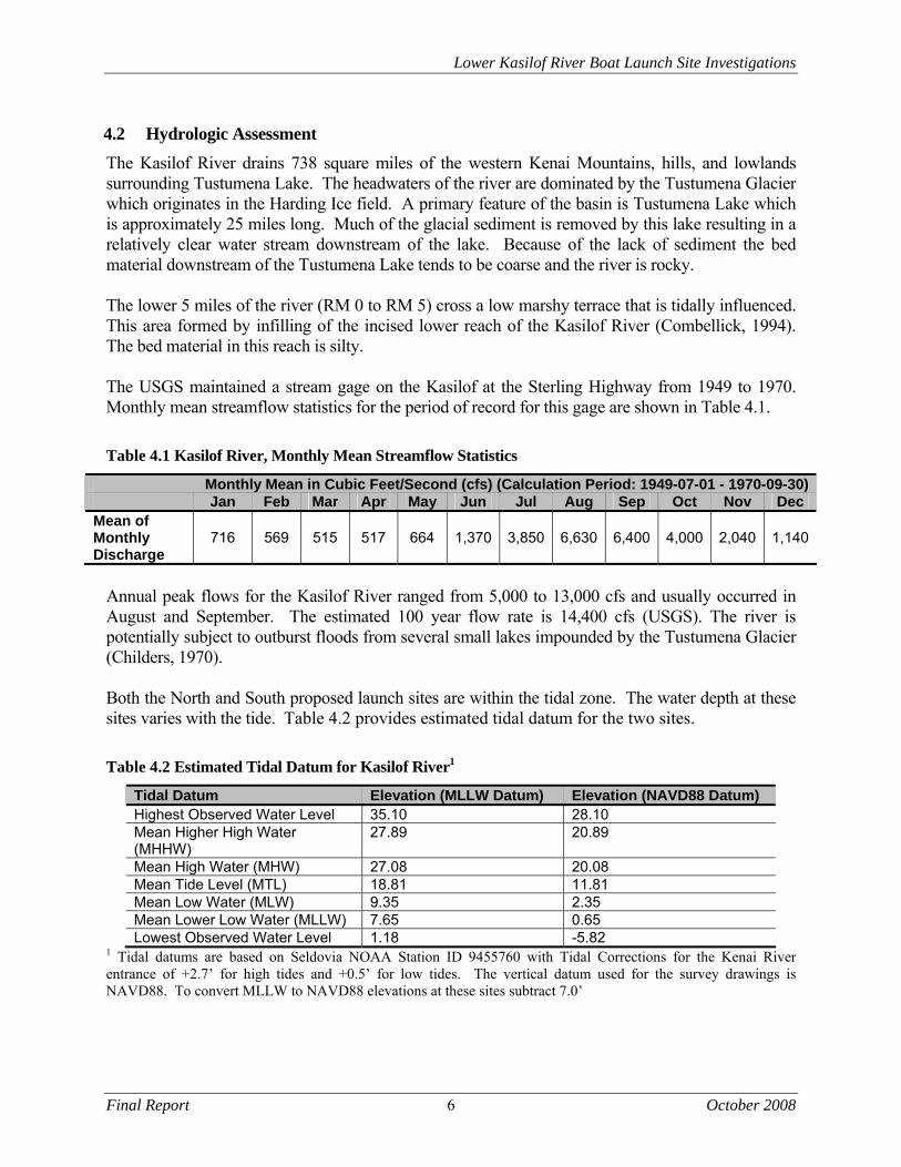
The Kasilof River drains 738 square miles of the western Kenai Mountains, hills, and lowlands surrounding Tustumena Lake. The headwaters of the river are dominated by the Tustumena Glacier which originates in the Harding Ice field. A primary feature of the basin is Tustumena Lake which is approximately 25 miles long. Much of the glacial sediment is removed by this lake resulting in a relatively clear water stream downstream of the lake. Because of the lack of sediment the bed material downstream of the Tustumena Lake tends to be coarse and the river is rocky. The lower 5 miles of the river (RM 0 to RM 5) cross a low marshy terrace that is tidally influenced. This area formed by infilling of the incised lower reach of the Kasilof River (Combellick, 1994). The bed material in this reach is silty. The USGS maintained a stream gage on the Kasilof at the Sterling Highway from 1949 to 1970. Monthly mean streamflow statistics for the period of record for this gage are shown in Table 4.1.
Table 4.1 Kasilof River, Monthly Mean Streamflow Statistics
Monthly Mean in Cubic Feet/Second (cfs) (Calculation Period: 1949-07-01 - 1970-09-30) Jan Feb Mar Apr May Jun Jul Aug Sep Oct Nov Dec Mean of Monthly Discharge
716 569 515 517 664 1,370 3,850 6,630 6,400 4,000 2,040 1,140
Annual peak flows for the Kasilof River ranged from 5,000 to 13,000 cfs and usually occurred in August and September. The estimated 100 year flow rate is 14,400 cfs (USGS). The river is potentially subject to outburst floods from several small lakes impounded by the Tustumena Glacier (Childers, 1970). Both the North and South proposed launch sites are within the tidal zone. The water depth at these sites varies with the tide. Table 4.2 provides estimated tidal datum for the two sites.
Table 4.2 Estimated Tidal Datum for Kasilof River1
Tidal Datum Elevation (MLLW Datum) Elevation (NAVD88 Datum) Highest Observed Water Level 35.10 28.10 Mean Higher High Water (MHHW)
27.89 20.89
Mean High Water (MHW) 27.08 20.08 Mean Tide Level (MTL) 18.81 11.81 Mean Low Water (MLW) 9.35 2.35 Mean Lower Low Water (MLLW) 7.65 0.65 Lowest Observed Water Level 1.18 -5.82
1 Tidal datums are based on Seldovia NOAA Station ID 9455760 with Tidal Corrections for the Kenai River entrance of +2.7’ for high tides and +0.5’ for low tides. The vertical datum used for the survey drawings is NAVD88. To convert MLLW to NAVD88 elevations at these sites subtract 7.0’
Lower Kasilof River Boat Launch Site Investigations
Final Report 7 October 2008
4.3 Site Evaluation
The two sites were each evaluated for the following:
Site parameters including area, legal description, access, and location on river Hydrologic issues including channel stability, tidal effects, water depth, flood hazard, and
ice affects Constructability issues including topography, soils, and wetlands Potential for site contamination Cultural resources Capitol and operations and maintenance (O&M) costs
A concept level site plan was developed for each site. This plan included the following features:
Table 4.3 Design Criteria
Ramp Number of Lanes: 2 Slope: 15%, vertical curve at transition Lane Width: 16 feet. 2 foot shoulders on outside edge of ramp Min. Depth at Toe of Ramp 4 feet below design low water (for power boat
usage) Design High water: Mean Higher High Water (MHHW) Ramp Materials: Concrete plank below design high water, asphalt
above design high water Parking Total Spaces: 75 spaces, 25 @ 10’ x 20’, 50 @ 12’ x 50’, gravel
surface Handicap Parking: 2 spaces @ 15’ x 40’, 1 spae @ 14’ x 20’ (included
in above total spaces), paved surface Access Roads: One way, 20 feet wide, Two ways, 24 feet wide,
paved surface Design Vehicle: MH/B, overall length of 53’, minimum radius of turn
of 50 feet. Other Amenities Vault Toilet Dumpster and Screen Kids-Don’t-Float Rack Campground Host Pad
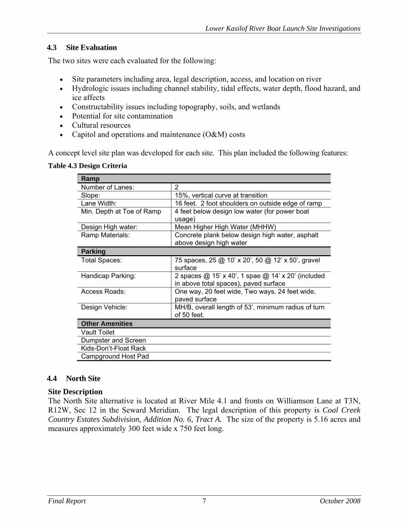
4.4 North Site
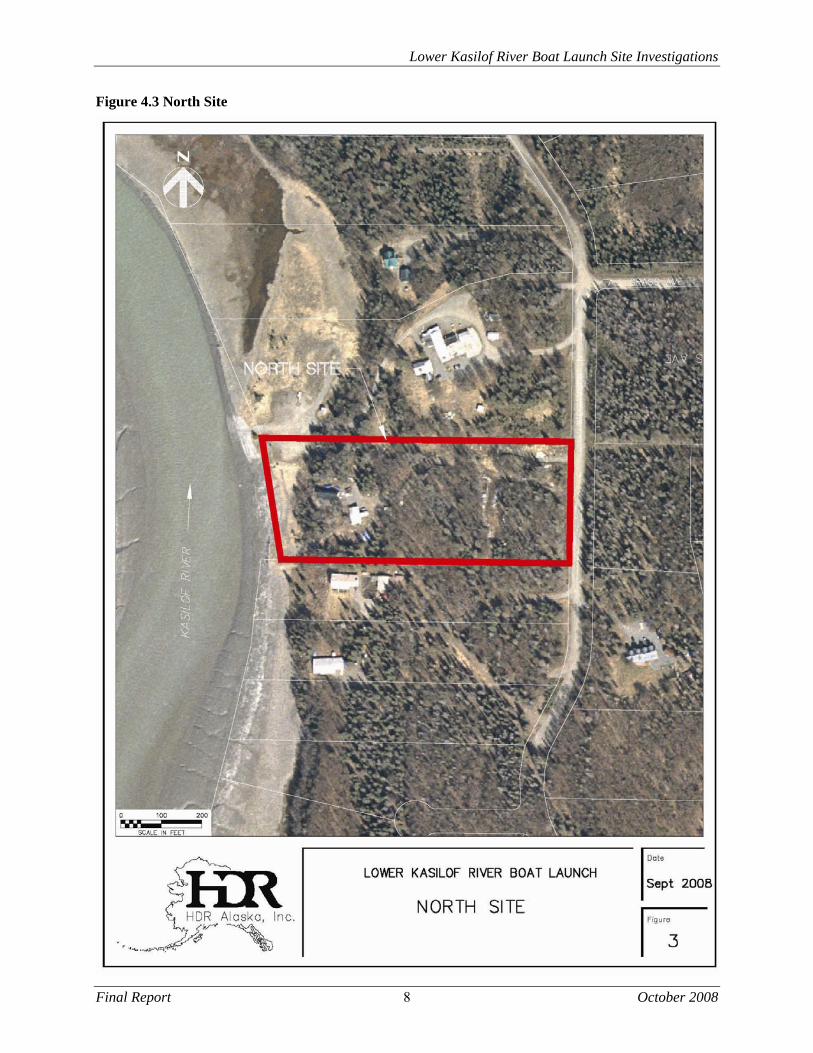
Site Description The North Site alternative is located at River Mile 4.1 and fronts on Williamson Lane at T3N, R12W, Sec 12 in the Seward Meridian. The legal description of this property is Coal Creek Country Estates Subdivision, Addition No. 6, Tract A. The size of the property is 5.16 acres and measures approximately 300 feet wide x 750 feet long.
Lower Kasilof River Boat Launch Site Investigations
Final Report 8 October 2008
Figure 4.3 North Site

Lower Kasilof River Boat Launch Site Investigations
Final Report 9 October 2008
The North Site is presently in residential use and has a small “A frame” home, a shop outbuilding and a well. There is a powerline along the north edge of the property. The north boundary of the site is along a section line and abuts an existing private boat launch. The south boundary of the site abuts another residential lot. There is no zoning in this area. Specific platted portions of the surrounding Coal Creek Country Estates subdivision have protective covenants which state that “No lots shall be used except for residential purposes.”, but the subject lot is not included in these portions of the Coal Creek Country Estates subdivision and does not appear to have protective covenants. Road access to the site is via Kalifonsky Beach Road to Satori Drive to Old Kasilof Road to Tall Grass Avenue to Williamson Lane. Kalifonsky Beach Road is a paved collector road, and the remainder of the roads along the access route are gravel secondary streets that serve the local residential subdivisions. Approximate road and river distances from the site to other locations are shown in Table 4.3 below.
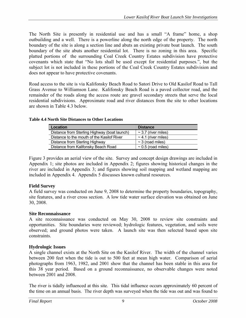
Table 4.4 North Site Distances to Other Locations
Location Distance Distance from Sterling Highway (boat launch) ~ 3.7 (river miles) Distance to the mouth of the Kasilof River ~ 4.1 (river miles) Distance from Sterling Highway ~ 3 (road miles) Distance from Kalifonsky Beach Road ~ 0.5 (road miles)
Figure 3 provides an aerial view of the site. Survey and concept design drawings are included in Appendix 1; site photos are included in Appendix 2; figures showing historical changes in the river are included in Appendix 3; and figures showing soil mapping and wetland mapping are included in Appendix 4. Appendix 5 discusses known cultural resources. Field Survey A field survey was conducted on June 9, 2008 to determine the property boundaries, topography, site features, and a river cross section. A low tide water surface elevation was obtained on June 30, 2008. Site Reconnaissance A site reconnaissance was conducted on May 30, 2008 to review site constraints and opportunities. Site boundaries were reviewed; hydrologic features, vegetation, and soils were observed; and ground photos were taken. A launch site was then selected based upon site constraints. Hydrologic Issues A single channel exists at the North Site on the Kasilof River. The width of the channel varies between 200 feet when the tide is out to 500 feet at mean high water. Comparison of aerial photographs from 1963, 1982, and 2001 show that the channel has been stable in this area for this 38 year period. Based on a ground reconnaissance, no observable changes were noted between 2001 and 2008. The river is tidally influenced at this site. This tidal influence occurs approximately 60 percent of the time on an annual basis. The river depth was surveyed when the tide was out and was found to
Lower Kasilof River Boat Launch Site Investigations
Final Report 10 October 2008
be 2.6 feet deep. This depth is less than the minimum 4 feet desired to launch or retrieve a power boat, but the 4 foot minimum depth would be met for the majority of time when the tide is in. The 2.6’ depth would be sufficient to launch or retrieve a drift boat. The slope of the riverbank is typically about 3H:1V. This slope breaks at about elevation 10 (17’ tidal datum) and a grassed tidal wetland exists above this elevation to the toe of the uplands. Peak flooding in this area would be due to extreme tidal events and would not be due to high flow events in the Kasilof River. Sedimentation will occur in this area during the quiescent period when the tide is in. It is not expected that sedimentation will be a large amount, as the source of the sediment is primarily from Cook Inlet and the site is 4.1 miles upstream from the mouth of the Kasilof River. The influence of ice in this area is unknown. It is expected that, typical to other tidal estuaries, the tidal zone will be filled with ice, and this ice will rise and fall daily with the tidal fluctuations. Any structures in this area should be designed to withstand this ice movement. Topography, Soil, Vegetation, & Wetlands From the Kasilof River east to Williamson Road the North Site has three defined benches separated by 20 to 25 foot tall slopes. The first bench is the tidal wetlands which extends to the tree line and ranges in elevation from 10 to 20 feet. The second bench ranges in elevation from 45 to 50 feet and the third bench is at elevation 70 feet. The NRCS Soil Survey of Western Kenai Peninsula Area classifies the upland soils on the North Site as silt loams with a representative profile of up to 2 feet of silt loam containing ash and loess (wind deposited soil) underlain by sandy and gravelly drift. The soil is typically well drained with low runoff. The water table is typically greater than 5 feet below the ground surface. The tidal area at this site is classified as up to 6 inches of silty material over sandy and silty marine deposits. These classifications were generally confirmed by field observation, but no detailed soils explorations were done as part of this project. Soils mapping is included in Appendix 4. Approximately 0.1 acre of tidally influenced emergent wetland occurs along the edge of Kasilof River at the North site. Common plant species present in these mudflat wetlands include Lyngbye sedge (Carex lyngbyei), beach ryegrass (Elymus arenarius) and bluejoint reedgrass (Calamagrostis canadensis). This wetland type is likely inundated periodically by tides and may be subject to overbank flooding by the Kasilof River during high flow events. The remainder of the North site is dominated by an upland plant community comprised of mature needleleaf evergreen forest. Common plant species seen in site photographs from this upland type include white spruce (Picea glauca), paper birch (Betula papyrifera), bluejoint reedgrass, raspberry (Rubus idaeus), prickly rose (Rosa acicularis), fireweed (Epilobium angustifolium), geranium (Geranium erianthum), yarrow (Achillea borealis), crowberry (Empetrum nigrum), low-bush cranberry (Vaccinium vitis-idaea), lupine (Lupinus nootkatensis), and oak fern (Gymnocarpium dryopteris). Hazardous Waste Material Assessment A site reconnaissance to assess the potential for site contamination was completed in September 2008 and is included in Appendix 8. No significant current contamination was identified on this property.
Lower Kasilof River Boat Launch Site Investigations
Final Report 11 October 2008
Historical, Archaeological, & Cultural Properties On May 8 and May 20, 2008, cultural resource records were reviewed at the Office of History
and Archaeology (OHA). According to the Alaska State Heritage Resource Survey records,
maintained by the OHA, there is one archaeological site (KEN-00190) documented within the
project area’s North Site. Site KEN-0000190 encompasses the entire area from the North Site to
Coal Creek and was recorded as the remains of a former fox farm constructed above an older
Native (Dena΄ina/Tanaina) village site. An unevaluated boating dock is located on the north site.
A field visit will be required to evaluate this structure’s eligibility for listing on the National
Register of Historic Places. Prior to design an archeological survey would need to be conducted
for the North Site.
Conceptual Site Plans
A concept site plan is shown in Appendix 1. The location selected for the ramp is on the
upstream (south) side of the North Site. At this location there is an existing fill that was placed
into the tidal wetlands. Constructing the ramp at this location will disturb the least amount of
tidal wetlands. The ramp is located to maintain a minimum 20 foot wide naturally vegetated
buffer along the south boundary.
The topography of the North Site presents a challenge to the layout of a boat launch. The
vertical distance from the upland bench to the toe of the boat ramp is approximately 46 feet. At a
slope of 15% (the maximum desirable for a boat launch) the length of the ramp is approximately
300 feet. Of this 300 feet, approximately 150 feet (to MHHW), would be constructed of
concrete planks and the remainder would be paved. A profile and cross sections of this ramp are
shown in Appendix 1.
The entrance to the North Site would be on the north side of the property. Parking would be
located on both the middle and upper benches. The existing house and shop buildings would be
removed and a campground host pad and toilets constructed. A naturally vegetated buffer would
be maintained between parking areas and property boundaries. Traffic flow is shown on the site
plan. The site can accommodate the design number of parking spaces, but there is no room for
future expansion.
Concept Cost Estimates
The estimated construction cost for the North Site is $2.3 million. This cost does not include site
acquisition costs. Estimated operations and maintenance costs are approximately $64,000 per
year assuming 5 months operation and a paid operator on site. Detailed cost estimates are
included in Appendix 1.
4.5 South Site
Site Description
The South Site alternative is located at RM 4.5 and fronts on Silver Fox Drive at T3N, R12W,
Sec 13 in the Seward Meridian. The legal description of this property is Government Lot 6 & 11
excluding Foxhills Estates Subdivision Part One. The size of the property is 51 acres but
approximately 23 of these acres lie within the tidal zone or are wetlands of other types. The
usable portion of the property is approximately 500 feet x 2600 feet. Only a portion of this
property is required for the ramp and associated parking. The north boundary of this property
abuts property owned by ADNR. The ADNR property was also reviewed as a potential boat
Lower Kasilof River Boat Launch Site Investigations
Final Report 12 October 2008
launch site, but was found to be primarily composed of wetlands with insufficient uplands to meet the requirements for a launch site. The South Site is presently undeveloped, but was used as a fox farm and has two structures; an “ice house” and a small outbuilding located on the shoreline. The foundations of a third structure are also on the site. A power line extends into the property from the north edge. There is no zoning in this area. Road access to the site is via Kalifonsky Beach Road to Silver Fox Drive. Kalifonsky Beach Road is a paved collector road and Silver Fox Drive is a graveled secondary street. The land along Silver Fox Drive has been platted, but to date no development has occurred. The approximate road and river distances from the South Site to other locations are shown in Table 4.4.
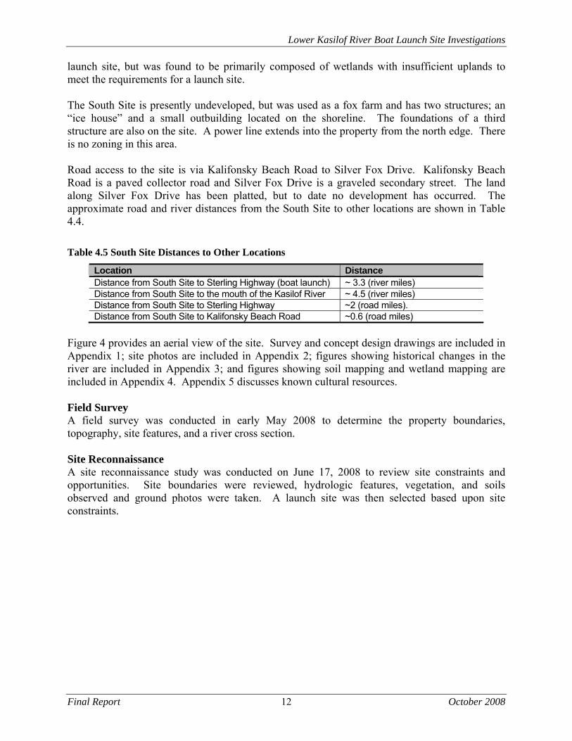
Table 4.5 South Site Distances to Other Locations
Location Distance Distance from South Site to Sterling Highway (boat launch) ~ 3.3 (river miles) Distance from South Site to the mouth of the Kasilof River ~ 4.5 (river miles) Distance from South Site to Sterling Highway ~2 (road miles). Distance from South Site to Kalifonsky Beach Road ~0.6 (road miles)
Figure 4 provides an aerial view of the site. Survey and concept design drawings are included in Appendix 1; site photos are included in Appendix 2; figures showing historical changes in the river are included in Appendix 3; and figures showing soil mapping and wetland mapping are included in Appendix 4. Appendix 5 discusses known cultural resources. Field Survey A field survey was conducted in early May 2008 to determine the property boundaries, topography, site features, and a river cross section. Site Reconnaissance A site reconnaissance study was conducted on June 17, 2008 to review site constraints and opportunities. Site boundaries were reviewed, hydrologic features, vegetation, and soils observed and ground photos were taken. A launch site was then selected based upon site constraints.
Lower Kasilof River Boat Launch Site Investigations
Final Report 13 October 2008
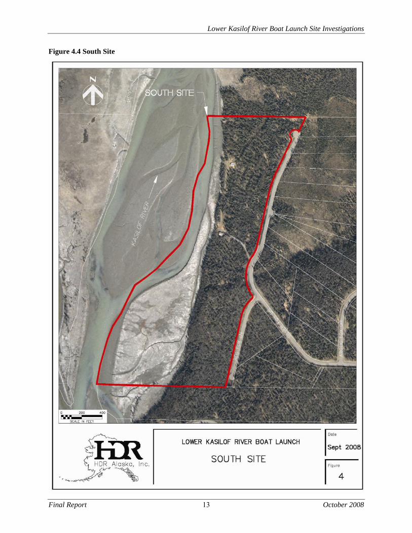
Figure 4.4 South Site

Lower Kasilof River Boat Launch Site Investigations
Final Report 14 October 2008
Hydrologic Issues The Kasilof River splits into two channels a half mile upstream of this site. A cross section of the river shows the eastern channel to be 1 foot deeper than the western channel, but the western channel is wider, consistently deeper, and has a greater cross sectional area. Comparison of aerial photographs from 1963, 1982, and 2001 show that this channel split has been stable for this 38 year period and the flows in each channel appear to be equal. Based on a ground reconnaissance, no observable changes were noted between 2001 and 2008. A comparison of the 1982 and 2001 photography showed that in the area of the proposed launch site there appears to have been deposition over that 20 year period. Presently, the shoreline appears to be stable. The Kasilof River is tidally influenced at the South Site. This tidal influence occurs approximately 40 percent of the time annually. The river depth was surveyed when the tide was out and found to be 2 feet deep. This depth is less than the minimum 4 feet desired to launch or retrieve a power boat, but the 4 foot minimum depth would be met for the majority of time when the tide is in. The 2.0’ depth would be sufficient to launch or retrieve a drift boat. The slope of the riverbank is typically about 3H:1V. This slope breaks at approximately elevation 12 (19’ tidal datum) and a grassed tidal wetland exists above this elevation to the toe of the uplands. Peak flooding in this area would be due to extreme tidal events and would not be due to high flow events in the Kasilof River. Sedimentation will occur in this area during the quiescent period when the tide is in. It is not expected that this sedimentation will be a large amount, as the source of the sediment is primarily from Cook Inlet and the site is 4.4 miles upstream from the mouth of the Kasilof River. The influence of ice in this area is unknown. It is expected that, typical to other tidal estuaries, the tidal zone will be filled with ice, and this ice will rise and fall daily with the tidal fluctuations. Any structures in this area should be designed to withstand this ice movement. Topography, Soil, Vegetation, & Wetlands From the Kasilof River east to Silverfox Drive the site has two defined benches separated by a 15 foot rise. The first bench is the tidal wetlands which extend to the tree line and range in elevation from 12 to 13 feet. The second bench ranges in elevation from 28 to 23 feet, and slopes downward away from the river. The NRCS Soil Survey of Western Kenai Peninsula Area classifies the upland soils on the South Site as silt loams with a representative profile of up to 2 feet of silt loam containing ash and loess underlain by sandy and gravelly glaciofluvial deposits. The soil is typically somewhat poorly drained with low runoff. The water table is typically greater than 5 feet below the ground surface. The tidal area at this site is classified as up to 6 inches of silty material over sandy and silty marine deposits. These classifications were confirmed by field observation, but no detailed soils explorations were done as part of this project. Soils mapping is included in Appendix 4. Approximately 6.9 acres of tidally influenced emergent wetlands were mapped within the ADNR parcel; 19.4 acres cover the privately-owned parcel south of the ADNR parcel. Common graminoid plant species that occur in this wetland type include Lyngbye sedge, beach ryegrass, and bluejoint reedgrass.
Lower Kasilof River Boat Launch Site Investigations
Final Report 15 October 2008
Areas that are not subject to tidal flooding include scrub-shrub wetlands, forested wetlands, and uplands. Broadleaved scrub-shrub wetlands occur across several flat, low-lying areas adjacent to Silver Fox Drive and along two drainage corridors extending between a large wetland complex east of Silver Fox Drive and the Kasilof River. A total of 4.3 acres of scrub-shrub wetland type cover the DNR parcel; 1.2 acres of this wetland type are found on the private parcel. Site photographs indicate that common plant species in the broad-leaved dominated scrub-shrub communities to include an overstory of Sitka alder (Alnus sinuata) and willow (Salix sp.) with an understory dominated by bluejoint reedgrass. Approximately 10.9 acres of needleleaved forested wetlands also occur at the South site; 8.5 acres covering the ADNR parcel and 2.4 acres covering the private parcel. On aerial photography, forested wetlands areas were delineated across flat, low-lying areas where stunted trees are visible and in locations where a dense understory of broadleaved shrubs is present. Areas with large, mature spruce that dominate the overstory with a sparsely vegetated understory where determined to be non-wetland. Needle-leaved forest communities appear to be dominated by an open canopy of stunted spruce (Picea sp.), willow, and Sitka alder. Common low-lying species seen on site photographs include bluejoint reedgrass, Labrador tea (Ledum groenlandicum), and crowberry. The remainder of the South site, similar to the North site is dominated by mature needleleaf evergreen forest. Uplands comprise 36.5 acres of the South site, covering 9.6 acres of the ADNR parcel, and 26.9 acres of the private parcel. Common plant species occurring in this upland type include white spruce, paper birch, bluejoint reedgrass, raspberry, prickly rose, fireweed, geranium, yarrow, crowberry, low-bush cranberry, lupine, and oak fern. Wetland mapping is included in Appendix x. Hazardous Waste Material Assessment A site reconnaissance to assess the potential for site contamination was completed in September 2008 and is included in Appendix 8. No significant current contamination was identified on this property. Historical, Archaeological, Cultural Properties On May 8 and May 20, 2008, cultural resource records were reviewed at the Office of History and Archaeology (OHA). According to the Alaska State Heritage Resource Survey records, maintained by the OHA, there is one archaeological site (KEN-00358) documented within the project area’s South Site. Site KEN-00358 was identified on the south end of the South Site and was recorded as four, Dena׳ina style house pits with associated features. The survey conducted for this site was cursory and site boundaries were not established but Site KET-00358 does not appears to be located in the footprint of the proposed launch site. Unevaluated remains of a former fox farm are located on this site. This fox farm may conflict with the footprint of the proposed launch site but sufficient acreage exists to rearrange the site plan if necessary in this area. Prior to design an archeological survey would need to be conducted for the South Site. Conceptual Site Plans A concept site plan is shown in Appendix 1. The location selected for the ramp is at the downstream (north) end of the property. A ramp could be located anywhere along approximately 800 feet of this shoreline but crowding it to the north makes best use of the available land, focuses the construction in an area that has already been disturbed, and keeps vehicle parking in the most well drained areas. The tidal wetlands are also narrowest in the north
Lower Kasilof River Boat Launch Site Investigations
Final Report 16 October 2008
end and constructing the ramp at this location will minimize the amount of disruptions to the
tidal wetlands.
The topography of the South Site lends itself well to the layout of a boat launch. The vertical
distance from the upland bench to the toe of the boat ramp is approximately 24 feet. At a slope
of 15% (the maximum desirable for a boat launch) the length of the ramp is approximately 160
feet. Of this 160 feet, approximately 110 feet (to MHHW), would be constructed of concrete
planks and the remainder would be paved. A profile and cross sections of this ramp are shown in
Appendix 1.
The entrance to the South Site would be on the north side of the property and would avoid
existing wetlands in the northeast corner. Parking would be located away from the shoreline and
a significant buffer could be maintained between vehicle parking and the riverbank. The existing
structure at the ramp site would be removed and a campground host pad and toilets constructed.
Traffic flow is shown on the site plan. The access roads, ramp and design number of parking
spaces can be accommodated within 10 acres of the parcel leaving significant buffers on all
sides. There is room for future expansion or a lesser amount of property could be purchased.
It has been suggested that entry to the South Site could be accessed directly from Kalifonsky
Beach road along an eastward extension of the north property line. A reconnaissance was made
of this route and it is not feasible. Approximately one third of the route is composed of wetlands
and there is a bluff approximately 600 feet east of the west property line that is too steep for a
road route.
Concept Cost Estimates
The estimated construction cost for the South Site is $2.1 million. This cost does not include site
acquisition costs. Estimated operations and maintenance costs are approximately $64,000 per
year assuming 5 months operation and a paid operator on site. Detailed cost estimates are
included in Appendix 1.
Lower Kasilof River Boat Launch Site Investigations
Final Report 17 October 2008
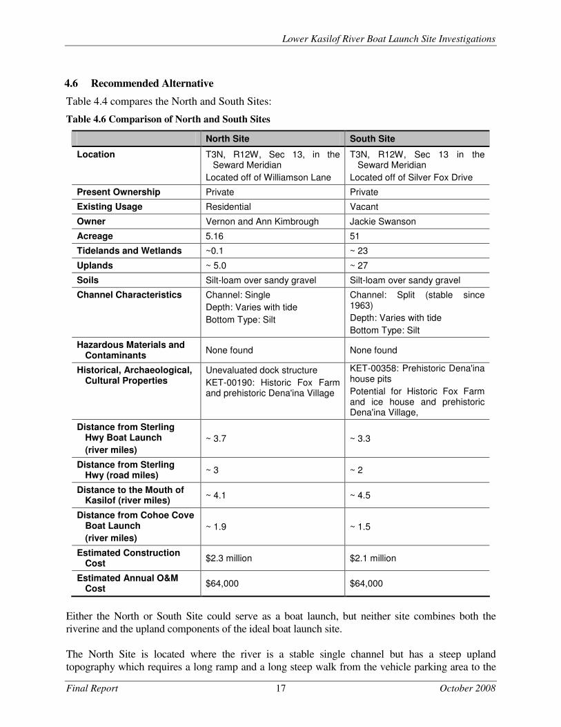
4.6 Recommended Alternative
Table 4.4 compares the North and South Sites:
Table 4.6 Comparison of North and South Sites
North Site South Site
Location T3N, R12W, Sec 13, in the Seward Meridian
Located off of Williamson Lane
T3N, R12W, Sec 13 in the Seward Meridian
Located off of Silver Fox Drive
Present Ownership Private Private
Existing Usage Residential Vacant
Owner Vernon and Ann Kimbrough Jackie Swanson
Acreage 5.16 51
Tidelands and Wetlands ~0.1 ~ 23
Uplands ~ 5.0 ~ 27
Soils Silt-loam over sandy gravel Silt-loam over sandy gravel
Channel Characteristics Channel: Single
Depth: Varies with tide
Bottom Type: Silt
Channel: Split (stable since 1963)
Depth: Varies with tide
Bottom Type: Silt
Hazardous Materials and Contaminants
None found None found
Historical, Archaeological, Cultural Properties
Unevaluated dock structure
KET-00190: Historic Fox Farm and prehistoric Dena'ina Village
KET-00358: Prehistoric Dena'ina house pits
Potential for Historic Fox Farm and ice house and prehistoric Dena'ina Village,
Distance from Sterling Hwy Boat Launch
(river miles) ~ 3.7 ~ 3.3
Distance from Sterling Hwy (road miles)
~ 3 ~ 2
Distance to the Mouth of Kasilof (river miles)
~ 4.1 ~ 4.5
Distance from Cohoe Cove Boat Launch
(river miles) ~ 1.9 ~ 1.5
Estimated Construction Cost
$2.3 million $2.1 million
Estimated Annual O&M Cost
$64,000 $64,000
Either the North or South Site could serve as a boat launch, but neither site combines both the
riverine and the upland components of the ideal boat launch site.
The North Site is located where the river is a stable single channel but has a steep upland
topography which requires a long ramp and a long steep walk from the vehicle parking area to the
Lower Kasilof River Boat Launch Site Investigations
Final Report 18 October 2008
boat launch. The North Site is also located in a residential area and vehicle traffic to the launch would be routed through a residential neighborhood. There is no room for expansion of this site. The South Site is located on a split channel segment of the river. This segment has been stable for the past 45 years and it is very likely, but there is no guarantee that this stability will continue into the future. Because of the split channels there is a possibility that first time drift boat users may miss the channel that leads to the launch and have a difficult time making their way back upstream to the launch site. The advantages of the South Site are that the upland portion of the site is level and would provide easy access from the vehicle parking area to the boat launch; the access route to the site is along residential roads but there is presently no development in this area and because of the layout of these residential lots the effect of launch traffic on these future residents would be minimal; and that the South Site could easily accommodate future expansion of vehicle parking or even be developed as a camping or picnic area. The construction and O&M costs for each site are similar. Site acquisition costs are not included in these estimates. The choice of which site is preferable will likely be made for other than technical reasons. For instance there may be strong public/user preference for a certain site, a seller may not be willing when funding becomes available to purchase a particular site, or there may be a desire by ADNR for an expanded facility, which only the South Site could provide.
5.0 Permitting
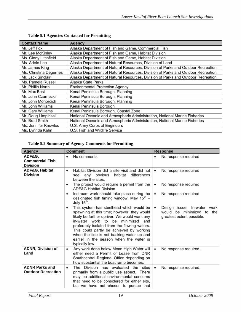
The following section describes the permitting issues for the North and South Sites. Local, state, and federal agencies were invited to a Preliminary Agency Scoping Meeting on June 25, 2008 to introduce the project and request comments from the agencies on the project (see Appendix 6). The agencies that were invited to participate in the project and to the meeting are listed in Table 5. Comments from the agencies were requested by August 5, 2008 and are summarized in Table 5.2 along with brief responses. Written comments are included in Appendix 6.
Lower Kasilof River Boat Launch Site Investigations
Final Report 19 October 2008
Table 5.1 Agencies Contacted for Permitting
Contact Name Agency Mr. Jeff Fox Alaska Department of Fish and Game, Commercial Fish Mr. Lee McKinley Alaska Department of Fish and Game, Habitat Division Ms. Ginny Litchfield Alaska Department of Fish and Game, Habitat Division Ms. Adele Lee Alaska Department of Natural Resources, Division of Land Mr. James King Alaska Department of Natural Resources, Division of Parks and Outdoor Recreation Ms. Christina Degernes Alaska Department of Natural Resources, Division of Parks and Outdoor Recreation Mr. Jack Sinclair Alaska Department of Natural Resources, Division of Parks and Outdoor Recreation Ms. Pamela Russell Alaska State Parks Mr. Phillip North Environmental Protection Agency Mr. Max Best Kenai Peninsula Borough, Planning Mr. John Czarnezki Kenai Peninsula Borough, Planning Mr. John Mohorcich Kenai Peninsula Borough, Planning Mr. John Williams Kenai Peninsula Borough Mr. Gary Williams Kenai Peninsula Borough, Coastal Zone Mr. Doug Limpinsel National Oceanic and Atmospheric Administration, National Marine Fisheries Mr. Brad Smith National Oceanic and Atmospheric Administration, National Marine Fisheries Ms. Jennifer Knowles U.S. Army Corps of Engineers Ms. Lynnda Kahn U.S. Fish and Wildlife Service
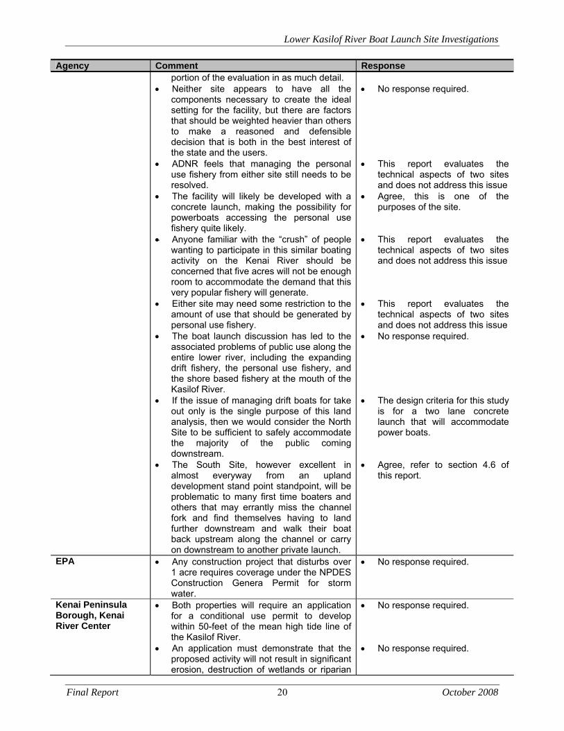
Table 5.2 Summary of Agency Comments for Permitting
Agency Comment Response ADF&G, Commercial Fish Division
No comments No response required
ADF&G, Habitat Division
Habitat Division did a site visit and did not see any obvious habitat differences between the sites.
The project would require a permit from the ADF&G Habitat Division.
Instream work should take place during the designated fish timing window, May 15th – July 15th.
This system has steelhead which would be spawning at this time; however, they would likely be further upriver. We would want any in-water work to be minimized and preferably isolated from the flowing waters. This could partly be achieved by working when the tide is not backing water up and earlier in the season when the water is typically low.
No response required No response required No response required Design issue. In-water work
would be minimized to the greatest extent possible.
ADNR, Division of Land
Any work done below Mean High Water will either need a Permit or Lease from DNR Southcentral Regional Office depending on how substantial the boat ramp becomes.
No response required.
ADNR Parks and Outdoor Recreation
The Division has evaluated the sites primarily from a public use aspect. There may be additional environmental concerns that need to be considered for either site, but we have not chosen to pursue that
No response required.
Lower Kasilof River Boat Launch Site Investigations
Final Report 20 October 2008
Agency Comment Response portion of the evaluation in as much detail.
Neither site appears to have all the components necessary to create the ideal setting for the facility, but there are factors that should be weighted heavier than others to make a reasoned and defensible decision that is both in the best interest of the state and the users.
ADNR feels that managing the personal use fishery from either site still needs to be resolved.
The facility will likely be developed with a concrete launch, making the possibility for powerboats accessing the personal use fishery quite likely.
Anyone familiar with the “crush” of people wanting to participate in this similar boating activity on the Kenai River should be concerned that five acres will not be enough room to accommodate the demand that this very popular fishery will generate.
Either site may need some restriction to the amount of use that should be generated by personal use fishery.
The boat launch discussion has led to the associated problems of public use along the entire lower river, including the expanding drift fishery, the personal use fishery, and the shore based fishery at the mouth of the Kasilof River.
If the issue of managing drift boats for take out only is the single purpose of this land analysis, then we would consider the North Site to be sufficient to safely accommodate the majority of the public coming downstream.
The South Site, however excellent in almost everyway from an upland development stand point standpoint, will be problematic to many first time boaters and others that may errantly miss the channel fork and find themselves having to land further downstream and walk their boat back upstream along the channel or carry on downstream to another private launch.
No response required. This report evaluates the
technical aspects of two sites and does not address this issue
Agree, this is one of the purposes of the site.
This report evaluates the
technical aspects of two sites and does not address this issue
This report evaluates the
technical aspects of two sites and does not address this issue
No response required. The design criteria for this study
is for a two lane concrete launch that will accommodate power boats.
Agree, refer to section 4.6 of
this report.
EPA Any construction project that disturbs over 1 acre requires coverage under the NPDES Construction Genera Permit for storm water.
No response required.
Kenai Peninsula Borough, Kenai River Center
Both properties will require an application for a conditional use permit to develop within 50-feet of the mean high tide line of the Kasilof River.
An application must demonstrate that the proposed activity will not result in significant erosion, destruction of wetlands or riparian
No response required. No response required.
Lower Kasilof River Boat Launch Site Investigations
Final Report 21 October 2008
Agency Comment Response habitat, or result in an increase of ground or water pollution.
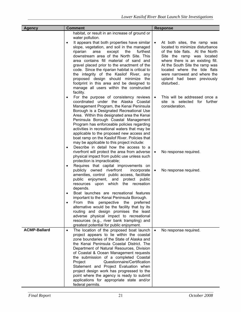
It appears that both properties have similar slope, vegetation, and soil in the managed riparian area except the furthest downstream area of the North Site. This area contains fill material of sand and gravel placed prior to the enactment of the code. Since the riparian habitat is critical to the integrity of the Kasilof River, any proposed design should minimize the footprint in this area and be designed to manage all users within the constructed facility.
For the purpose of consistency reviews coordinated under the Alaska Coastal Management Program, the Kenai Peninsula Borough is a Designated Recreational Use Area. Within this designated area the Kenai Peninsula Borough Coastal Management Program has enforceable policies regarding activities in recreational waters that may be applicable to the proposed new access and boat ramp on the Kasilof River. Policies that may be applicable to this project include:
Describe in detail how the access to a riverfront will protect the area from adverse physical impact from public use unless such protection is impracticable;
Requires that capital improvements on publicly owned riverfront incorporate amenities, control public access, facilitate public enjoyment, and protect public resources upon which the recreation depends.
Boat launches are recreational features important to the Kenai Peninsula Borough.
From this perspective the preferred alternative would be the facility that by its routing and design promises the least adverse physical impact to recreational resources (e.g., river bank trampling) and greatest potential for public enjoyment.
At both sites, the ramp was
located to minimize disturbance of the tide flats. At the North Site the ramp was located where there is an existing fill. At the South Site the ramp was located where the tide flats were narrowest and where the upland had been previously disturbed..
This will be addressed once a
site is selected for further consideration.
No response required. No response required.
ACMP-Ballard The location of the proposed boat launch project appears to lie within the coastal zone boundaries of the State of Alaska and the Kenai Peninsula Coastal District. The Department of Natural Resources, Division of Coastal & Ocean Management requests the submission of a completed Coastal Project Questionnaire/Certification Statement and Project Evaluation when project design work has progressed to the point where the agency is ready to submit applications for appropriate state and/or federal permits.
No response required.
Lower Kasilof River Boat Launch Site Investigations
Final Report 22 October 2008
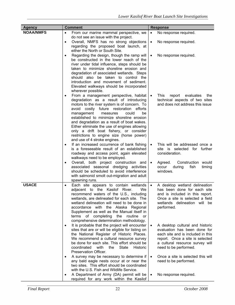
Agency Comment Response NOAA/NMFS From our marine mammal perspective, we
do not see an issue with the project. Overall, NMFS has no strong objections
regarding the proposed boat launch, at either the North or South Site.
Regarding the design, though the ramp will be constructed in the lower reach of the river under tidal influence, steps should be taken to minimize shoreline erosion and degradation of associated wetlands. Steps should also be taken to control the introduction and movement of sediment. Elevated walkways should be incorporated wherever possible.
From a management perspective, habitat degradation as a result of introducing motors to the river system is of concern. To avoid costly future restoration efforts management measures could be established to minimize shoreline erosion and degradation as a result of boat wakes. Either eliminate the use of engines allowing only a drift boat fishery, or consider restrictions to engine size (horse power) and use of 4 stroke engines.
If an increased occurrence of bank fishing is a foreseeable result of an established roadway and access point, again elevated walkways need to be employed.
Overall, both project construction and associated seasonal dredging activities should be scheduled to avoid interference with salmonid smolt out-migration and adult spawning runs.
No response required. No response required. No response required. This report evaluates the
technical aspects of two sites and does not address this issue
This will be addressed once a
site is selected for further consideration.
Agreed. Construction would
occur during fish timing windows.
USACE Each site appears to contain wetlands adjacent to the Kasilof River. We recommend waters of the U.S., including wetlands, are delineated for each site. The wetland delineation will need to be done in accordance with the Alaska Regional Supplement as well as the Manual itself in terms of completing the routine or comprehensive determination methodology.
It is probable that the project will encounter sites that are or will be eligible for listing on the National Register of Historic Places. We recommend a cultural resource survey be done for each site. This effort should be coordinated with the State Historic Preservation Officer.
A survey may be necessary to determine if any bald eagle nests occur at or near the two sites. This effort should be coordinated with the U.S. Fish and Wildlife Service.
A Department of Army (DA) permit will be required for any work within the Kasilof
A desktop wetland delineation has been done for each site and is included in this report. Once a site is selected a field wetlands delineation will be performed.
A desktop cultural and historic
evaluation has been done for each site and is included in this report. Once a site is selected a cultural resource survey will need to be performed.
Once a site is selected this will
need to be performed. No response required.
Lower Kasilof River Boat Launch Site Investigations
Final Report 23 October 2008
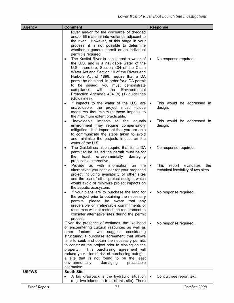
Agency Comment Response River and/or for the discharge of dredged and/or fill material into wetlands adjacent to the river. However, at this stage in your process, it is not possible to determine whether a general permit or an individual permit is required.
The Kasilof River is considered a water of the U.S. and is a navigable water of the U.S.; therefore, Section 404 of the Clean Water Act and Section 10 of the Rivers and Harbors Act of 1899, require that a DA permit be obtained. In order for a DA permit to be issued, you must demonstrate compliance with the Environmental Protection Agency’s 404 (b) (1) guidelines (Guidelines).
If impacts to the water of the U.S. are unavoidable, the project must include measures that minimize these impacts to the maximum extent practicable.
Unavoidable impacts to the aquatic environment may require compensatory mitigation. It is important that you are able to communicate the steps taken to avoid and minimize the projects impact on the water of the U.S.
The Guidelines also require that for a DA permit to be issued the permit must be for the least environmentally damaging practicable alternative.
Provide us with information on the alternatives you consider for your proposed project including availability of other sites and the use of other project designs which would avoid or minimize project impacts on the aquatic ecosystem.
If your plans are to purchase the land for the project prior to obtaining the necessary permits, please be aware that any irreversible or irretrievable commitments of resources will not restrict the requirement to consider alternative sites during the permit process.
Given the presence of wetlands, the likelihood of encountering cultural resources as well as other factors, we suggest considering structuring a purchase agreement that allows time to seek and obtain the necessary permits to construct the project prior to closing on the property. This purchasing agreement will reduce your clients’ risk of purchasing outright, a site that is not found to be the least environmentally damaging practicable alternative.
No response required. This would be addressed in
design. This would be addressed in
design. No response required. This report evaluates the
technical feasibility of two sites. No response required. No response required.
USFWS South Site A big drawback is the hydraulic situation
(e.g. two islands in front of this site). There
Concur, see report text.
Lower Kasilof River Boat Launch Site Investigations
Final Report 24 October 2008
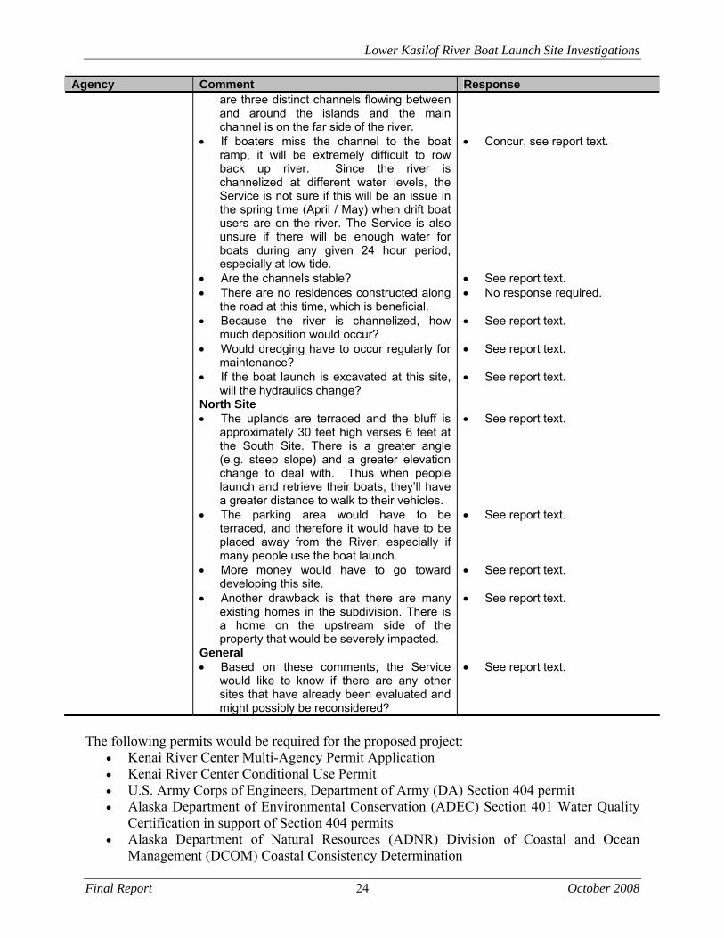
Agency Comment Response are three distinct channels flowing between and around the islands and the main channel is on the far side of the river.
If boaters miss the channel to the boat ramp, it will be extremely difficult to row back up river. Since the river is channelized at different water levels, the Service is not sure if this will be an issue in the spring time (April / May) when drift boat users are on the river. The Service is also unsure if there will be enough water for boats during any given 24 hour period, especially at low tide.
Are the channels stable? There are no residences constructed along
the road at this time, which is beneficial. Because the river is channelized, how
much deposition would occur? Would dredging have to occur regularly for
maintenance? If the boat launch is excavated at this site,
will the hydraulics change? North Site The uplands are terraced and the bluff is
approximately 30 feet high verses 6 feet at the South Site. There is a greater angle (e.g. steep slope) and a greater elevation change to deal with. Thus when people launch and retrieve their boats, they’ll have a greater distance to walk to their vehicles.
The parking area would have to be terraced, and therefore it would have to be placed away from the River, especially if many people use the boat launch.
More money would have to go toward developing this site.
Another drawback is that there are many existing homes in the subdivision. There is a home on the upstream side of the property that would be severely impacted.
General Based on these comments, the Service
would like to know if there are any other sites that have already been evaluated and might possibly be reconsidered?
Concur, see report text. See report text. No response required. See report text. See report text. See report text. See report text. See report text. See report text. See report text. See report text.
The following permits would be required for the proposed project:
Kenai River Center Multi-Agency Permit Application Kenai River Center Conditional Use Permit U.S. Army Corps of Engineers, Department of Army (DA) Section 404 permit Alaska Department of Environmental Conservation (ADEC) Section 401 Water Quality
Certification in support of Section 404 permits Alaska Department of Natural Resources (ADNR) Division of Coastal and Ocean
Management (DCOM) Coastal Consistency Determination
Lower Kasilof River Boat Launch Site Investigations
Final Report 25 October 2008
Alaska Department of Fish and Game (ADF&G) Division of Habitat Title 16 Fish Habitat permit
Alaska Department of Natural Resources Division of Land Permit or Lease from the Southcentral Regional Office
National Pollutant Discharge Elimination System (NPDES) General Permit for Storm Water Discharges from Large and Small Construction Activities (Construction General Permit, or CGP).
A Kenai River Center Multi-Agency Permit Application will be required to initiate the permitting process because project activities would occur within the KPB 50-foot Habitat Protection Area and include in-water use of an anadromous river and in wetlands. Additionally, a Kenai River Center Conditional Use Permit will be required because construction would take place within 50 feet of Ordinary High Water (OHW). A U.S. Army Corps of Engineers Department of Army (DA) Section 404 permit will be required for this project; however, at this stage in the process, it is not possible to determine whether a general permit or an individual permit is required. In addition, an ADEC Section 401 Water Quality Certification in support of the Section 404 permit will be needed. The location of the proposed boat launch lies within the Kenai Peninsula Coastal Zone Boundary; therefore a consistency determination from the Alaska Coastal Zone Management Program and a Coastal Zone Questionnaire will be required for this project. The Kasilof River is classified as an anadromous fish stream; therefore a Fish Habitat Title 16 permit from the Alaska Department of Fish and Game, Division of Habitat will be required for the construction of the proposed public boat launch because construction will take place in the river. The construction of the proposed boat launch will take place below Mean High Water; therefore, either a Permit or Lease from ADNR Southcentral Regional Office will be required. A NPDES General Permit for Storm Water Discharges from Large and Small Construction Activities will be required for this project because approximately 2 acres of land would be disturbed during the construction of the proposed boat launch. To minimize impacts within the project area, the following mitigation measures would be implemented:
Instream work will take place during the designated fish timing window, May 15th- July 15th.
There will be no vegetation clearing from May 1-July 15th. If active bald eagle nests are discovered within ½ mile form the project area, U.S. Fish
and Wildlife Service (USFWS) guidelines will be implemented for protection of eagles. If cultural, archaeological, or historical sites are discovered during project construction,
the State Historic Preservation Office (SHPO) will be contacted and any work that might impact these sites will be stopped. Work shall not resume in the vicinity of the site until a written clearance from SHPO is issued to the Project Engineer.
Lower Kasilof River Boat Launch Site Investigations
Final Report 26 October 2008
Additional mitigation measures will be implemented as the project progresses and through continued consultation with agencies.
6.0 Public Involvement
6.1 Public Involvement Plan
Information sharing is at the heart of any public process. The public involvement plan focused on this basic promise: We will keep you informed and provide opportunities for you to participate meaningfully in the decision-making process. The public process objectives for this project were to: Communicate the need for and goals of the project
Establish the need for the project. Explain the project, informing the public and stakeholders. Establish the responsibility of team members.
Demonstrate sensitivity and responsiveness to issues and ideas
Open and maintain communication channels. Get to know project area residents and interested individuals. See the project and the world through their eyes. Articulate and clarify key issues. Identify all the potentially relevant problems.
Facilitate communication and cooperation among all participants in the process
Make sure that all project communications are received and understood. Receive and understand all the information communicated to project team members. Demonstrate how the project team has responded to comments and concerns. Provide clarity on the lines of communication related to the project.
A public involvement plan was drafted in May 2008 that detailed specific public involvement tasks and strategies designed to achieve the objectives referenced above. The key activities were two public open houses to be held at key points during the project.
6.2 Public Meetings
The first project open house was held at Tustumena Elementary School in Kasilof on May 24, 2008. The purpose of the meeting was to present the project and solicit input from interested stakeholders. Members of the public visited stations to learn about the project background and alternatives under consideration, and to talk directly with the project team members. The public was notified of the open house through a post card mailing and radio and newspaper ads. Sixty-eight (68) people signed the sign-in sheet. Copies of the advertisements, meeting materials, and sign-in sheets can be found in Appendix 7: Public Involvement. A second public open house was held at the Tustumena Elementary School on September 30, 2008 to present the draft site investigation report, answer questions, and receive additional public input. The public was notified of the open house through a post card mailing and radio and newspaper ads. Thirty six (36) people signed the sign-in sheet.
Lower Kasilof River Boat Launch Site Investigations
Final Report 27 October 2008
During the course of public meetings it became apparent that there was overwhelming concern over issues occurring as a result of the personal use fishery and power boating use on the Kasilof River. Noise, hydrocarbon pollution, habitat degradation, sanitation and trash were some of the topics mentioned. These issues will continue to persist and may increase over time. One solution to address these issues would be to establish a Kasilof River Special Management Area similar to the Kenai River Special Management Area through the Department of Natural Resources, Division of Parks and Outdoor Recreation. This would allow a management plan to be created which would address the resources and needs of the recreating public.
6.3 Correspondence
A project-specific mailing list of more than 300 contacts was developed using parcel ownership data from the Kenai Peninsula Borough. This list was updated following the public open house and as written or e-mailed comments were received. Forty (40) written and e-mailed comments were received between March 1 and June 2, 2008; all comments were acknowledged via a personalized thank you letter. Issues raised included:
Motorized use Site locations Funding/Cost Infrastructure needs Historic properties Public use fishery Who benefits Land use restriction and covenants Traffic Dust Noise View shed Buffer zone Access Quality of life Competition with private facilities Need for project Safety
A summary of both the written comments as well as a phone log are included in Appendix 7: Public Involvement.
7.0 References
Alaska Department of Fish and Game (ADF&G). 2008a. Crooked Creek Chinook salmon escapement study. Northern Kenai Peninsula Sport Fisheries. Research. Sport Fish Division. <http://www.sf.adfg.state.ak.us/Management/Areas.cfm/FA/kenaiResearch.CCEscape>. Accessed July 23, 2008.
Lower Kasilof River Boat Launch Site Investigations
Final Report 28 October 2008
Alaska Department of Fish and Game (ADF&G). 2008b. Northern Kenai Peninsula Management Area Description. Northern Kenai Peninsula Sport Fisheries. Research. Sport Fish Division. <http://www.sf.adfg.state.ak.us/Management/areas.cfm/FA/kenai.overview>. Accessed July 23, 2008.
Alaska Department of Fish and Game (ADF&G). 2008c. 2008 Alaska Sport Fishing Regulations
Summary, South Central Alaska. Childers, J.M. 1970, Flood Frequency in Alaska, USGS Open File Report 70-63 Combellick, R.A., 1994, Investigation of Tidal Marshes Along Cook Inlet, DGGS report 94-7.

Appendices have been omitted due to the length of the document but are available upon request.