Embed Size (px)
Citation preview
APPENDIX M
Lower Feather River Corridor Management Plan Conceptual Restoration Plan

Lower Feather River Corridor Management Plan AECOM California Department of Water Resources M-1 Conceptual Restoration Plan
APPENDIX M LOWER FEATHER RIVER CORRIDOR MANAGEMENT PLAN CONCEPTUAL RESTORATION PLAN
M.1 INTRODUCTION
This Conceptual Restoration Plan for the Lower Feather River Corridor Management Plan (LFRCMP) describes
restoration actions and target habitats suitable for the Feather River setback (FRS) area and other managed
floodplains of the LFRCMP study area. It also presents a conceptual layout for the distribution of vegetation types
recommended for use in future restoration projects. This plan’s restoration actions complement and are integrated
with the actions described in LFRCMP Chapter 6, “Proposed Management Actions,” and with restoration actions
proposed by Three Rivers Levee Improvement Authority (TRLIA) and River Partners for 940 acres in the FRS area.
The target habitat types for restoration in the LFRCMP study area consist of riparian habitats (dense riparian
forest and riparian willow scrub) and native upland habitats (valley oak woodland, oak savanna/perennial
grassland, and native upland scrub). Expanding and connecting riparian and native upland habitats is a particular
focus of restoration efforts for the LFRCMP study area because the area historically supported such habitats and
because riparian and oak woodland vegetation communities contain the most species-rich and abundant
communities of birds and provide critically important habitat for many other wildlife species (Knopf et al. 1988).
Increasing the extent and connectivity of these habitats is also important because the number of wildlife species in
riparian and oak woodland corridors increases with corridor size, width, and continuity (e.g., Hagar 1999, Heath
and Ballard 2003).
Widening and connecting riparian and oak woodland corridors is crucial because narrow or fragmented corridors
are not suitable for the dispersal of some species, particularly smaller, less mobile animals (Rosenberg et al.
1997). For more widely distributed species, the value of wide, contiguous corridors may be related to increased
habitat heterogeneity in larger corridors; to the absence of interior habitats in narrower, fragmented corridors; and
to the ability of larger corridors to support species with larger home ranges.
Upland habitats in the LFRCMP study area also provide valuable resources for terrestrial wildlife, particularly
where those uplands occur as a mosaic with riparian forest, riparian willow scrub, valley oak woodland, native
perennial grassland, and other native plant communities. Many wildlife species require several habitat features
and use different vegetation types at various times during their life cycles. In the Sacramento Valley, many
riparian-associated species use—and often require—both riparian and other adjacent habitats (including uplands)
for reproduction, cover, and/or foraging (Placer County Planning Department 2005). Therefore, a mosaic of
riparian habitats, and habitats with diverse vegetation species and physical habitat structure, are more likely than
homogenous habitats to accommodate a wider variety of wildlife species (RHJV 2004). For this reason, creating
upland habitat that is intermixed with riparian and other habitats is a high priority for restoration efforts in the
LFRCMP study area.
The restoration actions described in this plan, and the management actions discussed in Chapter 6 of the
LFRCMP, would better reflect historic habitat conditions, and would increase the extent and quality of riparian,
valley oak woodland, and upland habitat for terrestrial wildlife in the LFRCMP study area. The management
actions described in Chapter 6 would create topographic and hydrologic conditions that support natural riverine
and successional processes. These actions, augmented by the plantings described in this plan, would create a
AECOM Lower Feather River Corridor Management Plan Conceptual Restoration Plan M-2 California Department of Water Resources
mosaic of riparian and upland habitats more closely replicating primordial conditions. Varying successional
stages of riparian habitat would be intermixed with native upland habitats. Fragmentation of native habitats would
be diminished, a diverse vegetative structure for riparian and upland wildlife species would be established, and
high-quality nutrient inputs would be provided to aquatic food chains.
The restoration actions would expand and connect existing swaths of riparian habitat in the LFRCMP study area,
improve the diversity and quality of existing riparian forests, and replace ruderal areas and annual grassland with
native oak savanna/perennial grassland and valley oak woodland. Some of the wildlife benefits of these
restoration actions would be achieved in a relatively short time frame; for example, increased species richness of
neotropical migratory birds is often seen within 3 years of restoration (RHJV 2004).
The following goals important to the overall management of the LFRCMP study area shaped the development of
the restoration actions described in this plan:
► No Increase in Flood Risk. Restoration actions will not increase flood risk, decrease levee freeboard,
adversely affect flood management infrastructure, or otherwise diminish public safety.
► Promote Natural Hydrologic Processes. Restoration actions will promote natural dynamic hydrologic and
geomorphic processes to the extent feasible, with an emphasis on frequently inundated floodplains.
► Expand and Connect Native Plant Communities. Restoration actions will increase the extent, quality,
diversity, and connectivity of riparian habitat, including shaded riverine aquatic habitats, and mosaics of
native upland/riparian plant communities.
► Promote Recovery and Stability of Native Fish and Wildlife Populations. Restoration actions will
promote the recovery and stability of special-status fish and wildlife and other populations of native species,
as well as enhance overall biotic diversity.
These principles are consistent with the Central Valley Flood Protection Plan (CVFPP) Conservation Framework
(DWR 2012) (see LFRCMP Chapter 1, “Introduction,” for a discussion of the relationship of the LFRCMP to the
CVFPP and the Conservation Framework).
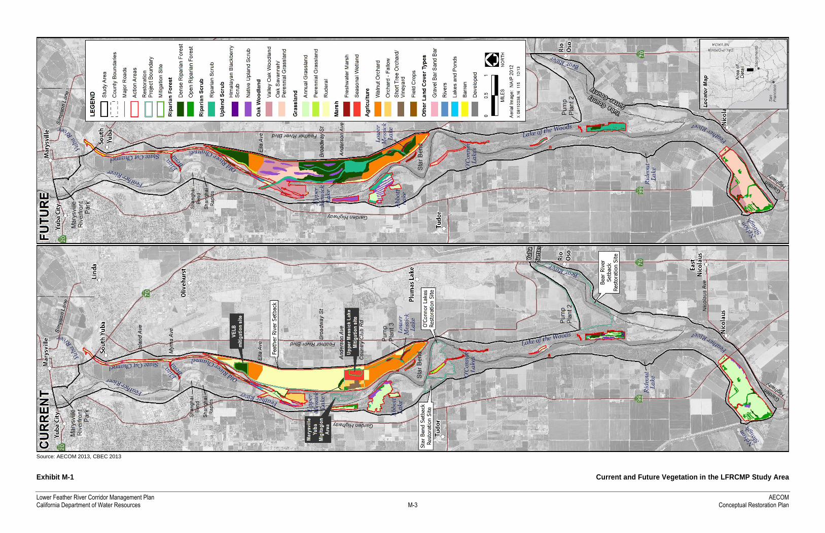
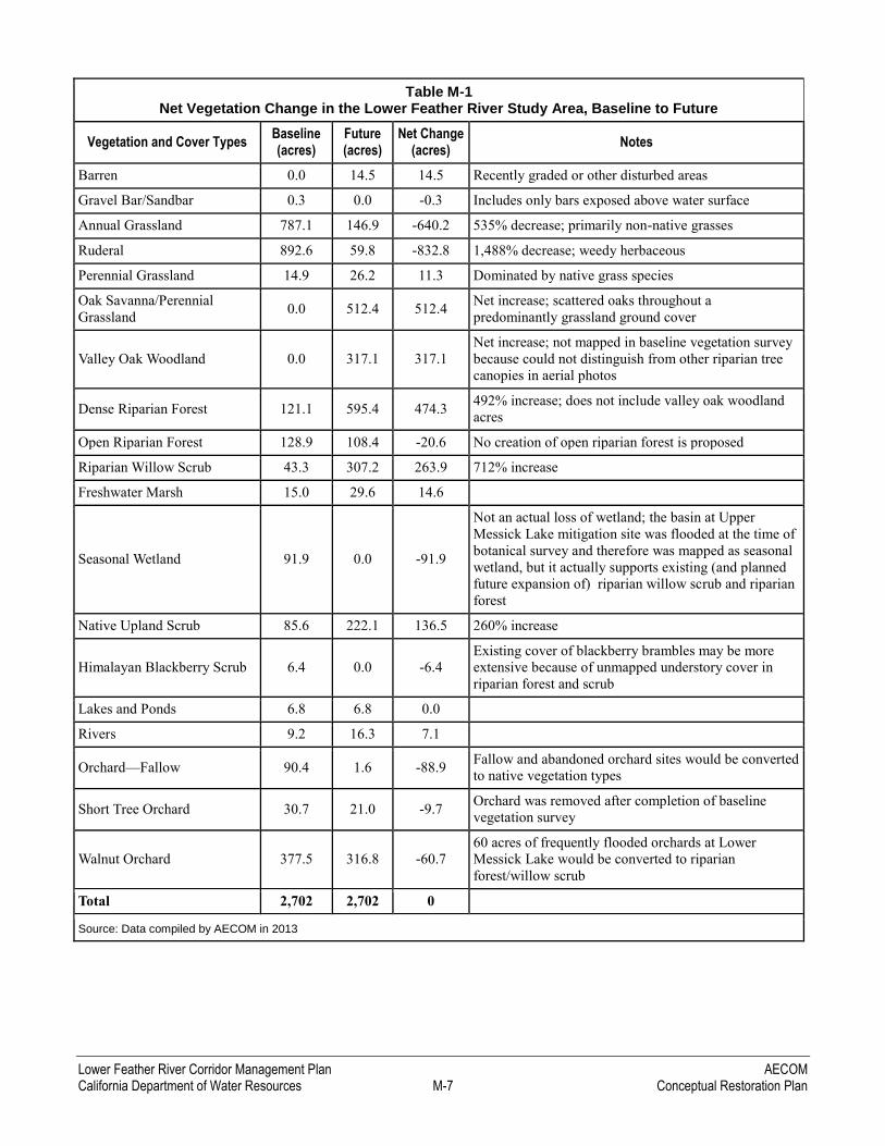
Table M-1 summarizes the extent to which the proposed restoration would increase high-value habitat types and
decrease undesirable vegetation types throughout the LFRCMP study area. Exhibit M-1 depicts the location of
current and future vegetation types in the LFRCMP study area.
M.2 COMPLETED AND PROPOSED RESTORATION PROJECTS IN THE LFRCMP STUDY AREA
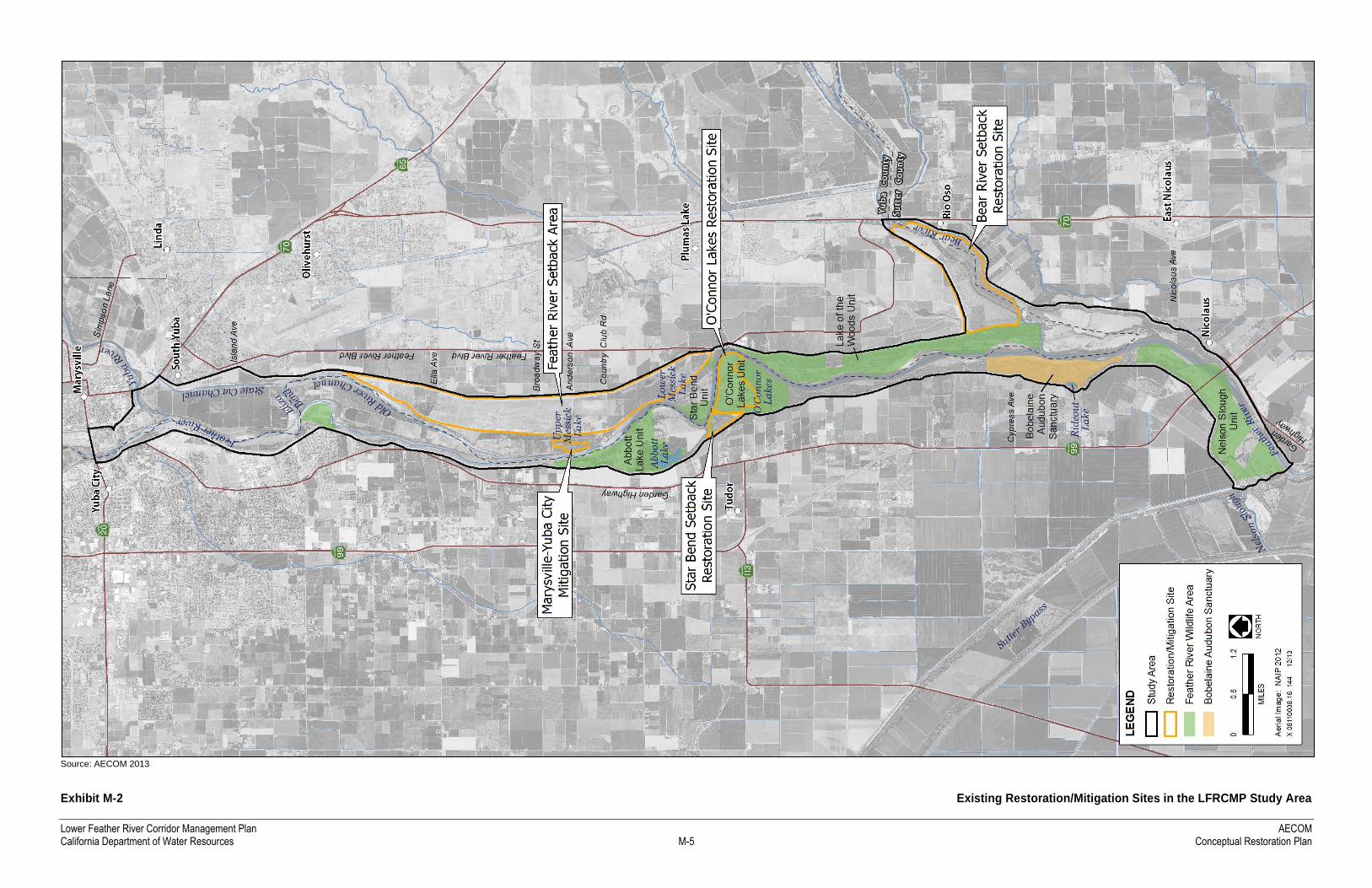
Several major restoration and habitat mitigation efforts have already been completed in the LFRCMP study area.
Exhibit M-2 shows the locations of these restoration sites, and Table M-2 summarizes the targeted habitat types
and the extent of habitat restored. Collectively, these projects substantially enhanced and will continue enhancing
biological resource values in the LFRCMP study area. These projects have expanded and enhanced native plant
communities, including riparian forest and scrub, freshwater marsh, shaded riverine aquatic habitat, native
perennial grasslands, and valley oak woodland. The restored plant communities have created and enhanced habitat
for special-status species such as Chinook salmon, Central Valley steelhead, Sacramento splittail, valley
elderberry longhorn beetle, Swainson’s hawk, and western yellow-billed cuckoo.
Lower Feather River Corridor Management Plan AECOM California Department of Water Resources M-3 Conceptual Restoration Plan
Source: AECOM 2013, CBEC 2013
Exhibit M-1 Current and Future Vegetation in the LFRCMP Study Area

Lower Feather River Corridor Management Plan AECOM California Department of Water Resources M-5 Conceptual Restoration Plan
Source: AECOM 2013
Exhibit M-2 Existing Restoration/Mitigation Sites in the LFRCMP Study Area

Lower Feather River Corridor Management Plan AECOM California Department of Water Resources M-7 Conceptual Restoration Plan
Table M-1 Net Vegetation Change in the Lower Feather River Study Area, Baseline to Future
Vegetation and Cover Types Baseline (acres)
Future (acres)
Net Change (acres)
Notes
Barren 0.0 14.5 14.5 Recently graded or other disturbed areas
Gravel Bar/Sandbar 0.3 0.0 -0.3 Includes only bars exposed above water surface
Annual Grassland 787.1 146.9 -640.2 535% decrease; primarily non-native grasses
Ruderal 892.6 59.8 -832.8 1,488% decrease; weedy herbaceous
Perennial Grassland 14.9 26.2 11.3 Dominated by native grass species
Oak Savanna/Perennial
Grassland 0.0 512.4 512.4
Net increase; scattered oaks throughout a
predominantly grassland ground cover
Valley Oak Woodland 0.0 317.1 317.1
Net increase; not mapped in baseline vegetation survey
because could not distinguish from other riparian tree
canopies in aerial photos
Dense Riparian Forest 121.1 595.4 474.3 492% increase; does not include valley oak woodland
acres
Open Riparian Forest 128.9 108.4 -20.6 No creation of open riparian forest is proposed
Riparian Willow Scrub 43.3 307.2 263.9 712% increase
Freshwater Marsh 15.0 29.6 14.6
Seasonal Wetland 91.9 0.0 -91.9
Not an actual loss of wetland; the basin at Upper
Messick Lake mitigation site was flooded at the time of
botanical survey and therefore was mapped as seasonal
wetland, but it actually supports existing (and planned
future expansion of) riparian willow scrub and riparian
forest
Native Upland Scrub 85.6 222.1 136.5 260% increase
Himalayan Blackberry Scrub 6.4 0.0 -6.4
Existing cover of blackberry brambles may be more
extensive because of unmapped understory cover in
riparian forest and scrub
Lakes and Ponds 6.8 6.8 0.0
Rivers 9.2 16.3 7.1
Orchard—Fallow 90.4 1.6 -88.9 Fallow and abandoned orchard sites would be converted
to native vegetation types
Short Tree Orchard 30.7 21.0 -9.7 Orchard was removed after completion of baseline
vegetation survey
Walnut Orchard 377.5 316.8 -60.7
60 acres of frequently flooded orchards at Lower
Messick Lake would be converted to riparian
forest/willow scrub
Total 2,702 2,702 0
Source: Data compiled by AECOM in 2013
AECOM Lower Feather River Corridor Management Plan Conceptual Restoration Plan M-8 California Department of Water Resources
Table M-2 Completed Restoration/Mitigation Projects in the LFRCMP Study Area
Restoration/Mitigation Project Habitat Types and Approximate Acres Restored
Feather River Setback Levee Project VELB habitat via elderberry shrub transplanting (38 acres)
Open water, Great Valley buttonbush scrub, Great Valley mixed riparian,
and Great Valley valley oak woodland (30.4 acres) (River Partners 2009a)
Bear River Setback Levee and Riparian
Restoration Project
Riparian forest and scrub, native perennial grassland, shaded riverine
aquatic habitat, freshwater marsh, and a drainage swale connected to the
Bear River (639 acres) (River Partners 2005)
Star Bend Setback Levee and Habitat
Enhancement Project
Riparian scrub, including VELB habitat via elderberry shrub transplanting
(20 acres) (River Partners 2009b)
O’Connor Lakes Unit Riparian Restoration Plan Riparian forest and scrub (228 acres connecting existing disjunct patches)
and native perennial grasslands (River Partners 2006)
Marysville–Yuba City Area Levee
Reconstruction Project (mitigation site)
Riparian forest and scrub, freshwater marsh, VELB habitat (35 acres)
(DWR 2011)
Note: VELB = valley elderberry longhorn beetle
Sources: DWR 2011; River Partners 2005, 2006, 2009a, 2009b
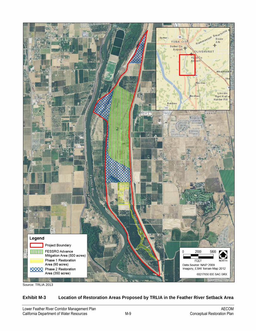
In addition to these completed projects, TRLIA has proposed to restore 500 acres of riparian and upland habitat in
the FRS area as part of the Feather River Floodway Corridor Restoration Project (TRLIA 2013). This project,
recommended for direct Proposition 1E funding by the California Department of Water Resources’ (DWR’s)
FloodSAFE Environmental Stewardship and Statewide Resources Office (FESSRO), would establish
approximately 300 acres of mixed riparian forest, riparian scrub, and valley oak woodland and approximately
200 acres of grassland (Exhibit M-3).
TRLIA has also proposed restoration under DWR’s Flood Protection Corridor Program for the Three Rivers
Flood Corridor Project. This proposal specifically requested funding to complete a design analysis of the
conceptual ecological restoration elements described in LFRCMP Chapter 4, “Management Goals, Challenges,
and Opportunities”: a system of excavated swales connecting the Feather River to the Upper and Lower Messick
Lake complex, upland refugia, and lowered floodplains within the FRS area. Implementing the TRLIA Three
Rivers Flood Corridor Project would result in restoration of 440 additional acres of dense riparian forest, riparian
scrub, valley oak woodland, and oak savanna/perennial grasslands.
M.3 MAJOR CONSTRAINTS TO RESTORATION SUCCESS
M.3.1 INUNDATION FREQUENCY
As described in LFRCMP Chapter 5, “Hydraulic, Hydrologic, and Sediment Transport Modeling of Potential
Future Conditions,” natural river processes such as frequent floodplain inundation and channel meander migration
have been significantly altered on the Lower Feather River by historical hydraulic mining deposits, subsequent
channel incision, dam and levee construction, water diversions, and reservoir storage operations.
In particular, floodplain inundation is an ecosystem process that is vital to the sustenance of riverine and riparian
ecosystems. Frequent, ecologically significant flood flows, referred to as the Floodplain Activation Flood (FAF)
Lower Feather River Corridor Management Plan AECOM California Department of Water Resources M-9 Conceptual Restoration Plan
Source: TRLIA 2013
Exhibit M-3 Location of Restoration Areas Proposed by TRLIA in the Feather River Setback Area
AECOM Lower Feather River Corridor Management Plan Conceptual Restoration Plan M-10 California Department of Water Resources
(PWA 2005), are typically associated with storms occurring more frequently than once every 2 years. These FAF
flows support highly beneficial ecological functions and outcomes such as producing organic matter and
invertebrates to fuel food webs, creating habitat that supports spawning and rearing by native fishes, and
promoting conditions that support recruitment of riparian vegetation.
As detailed in Chapter 5, the Feather River channel in the LFRCMP study area has become so incised, and the
river floodplain so disconnected from the channel by the combined effect of incision and dam operations, that
these ecologically significant FAF flows are more or less nonexistent under current conditions. The Feather River
and Bear River levee setback projects removed levees that separated the river floodplain from the river, offering
tremendous restoration opportunities in the new setback areas. Still, the high elevation of the floodplain relative to
the incised river channel in the FRS area remains a barrier to restoring the full natural dynamic processes that
support aquatic and terrestrial floodplain ecosystems.
Several management actions described in LFRCMP Chapter 6 would help restore natural floodplain inundation
processes by strategically excavating high-flow diversion swales, improving flow-through at existing basins and
drainages, opening access to old river channels, and creating low benches that would be subject to frequent
inundation. These actions would create conditions supporting a dynamic succession and mosaic of floodplain
habitat types.
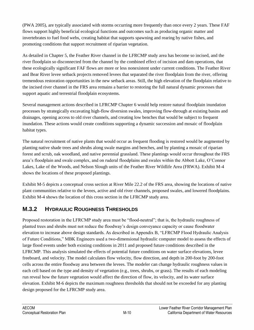
The natural recruitment of native plants that would occur as frequent flooding is restored would be augmented by
planting native shade trees and shrubs along swale margins and benches, and by planting a mosaic of riparian
forest and scrub, oak woodland, and native perennial grassland. These plantings would occur throughout the FRS
area’s floodplain and swale complex, and on ruderal floodplains and swales within the Abbott Lake, O’Connor
Lakes, Lake of the Woods, and Nelson Slough units of the Feather River Wildlife Area (FRWA). Exhibit M-4
shows the locations of these proposed plantings.
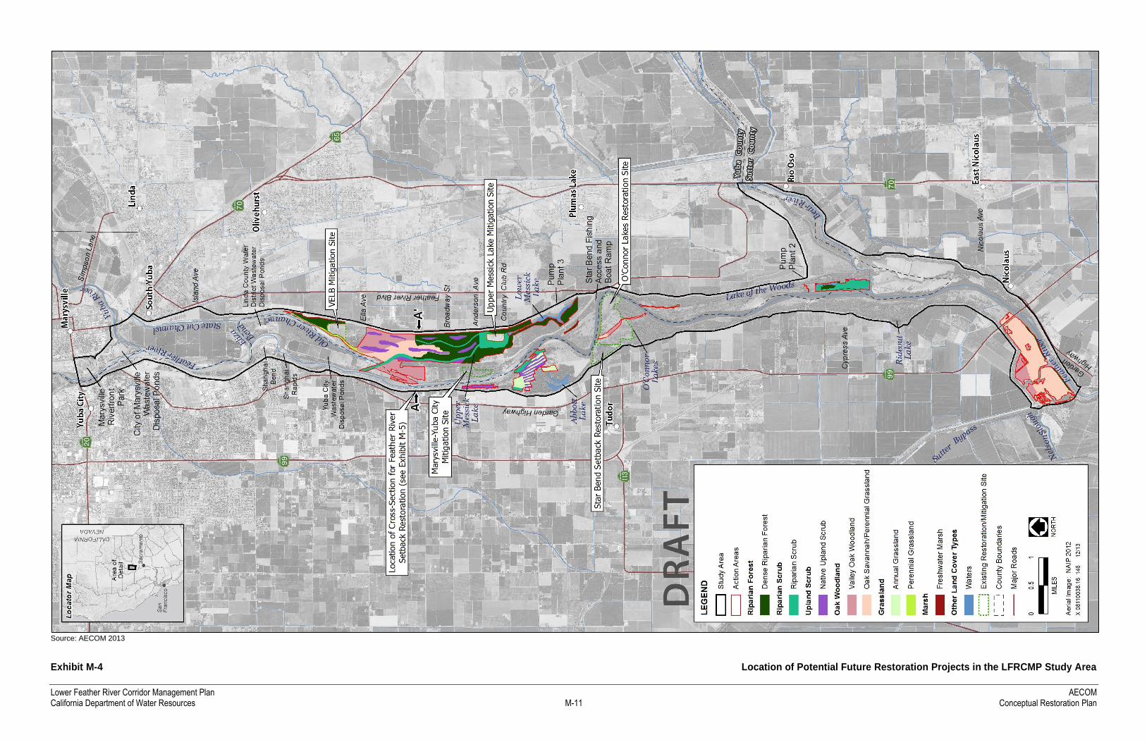
Exhibit M-5 depicts a conceptual cross section at River Mile 22.2 of the FRS area, showing the locations of native
plant communities relative to the levees, active and old river channels, proposed swales, and lowered floodplains.
Exhibit M-4 shows the location of this cross section in the LFRCMP study area.
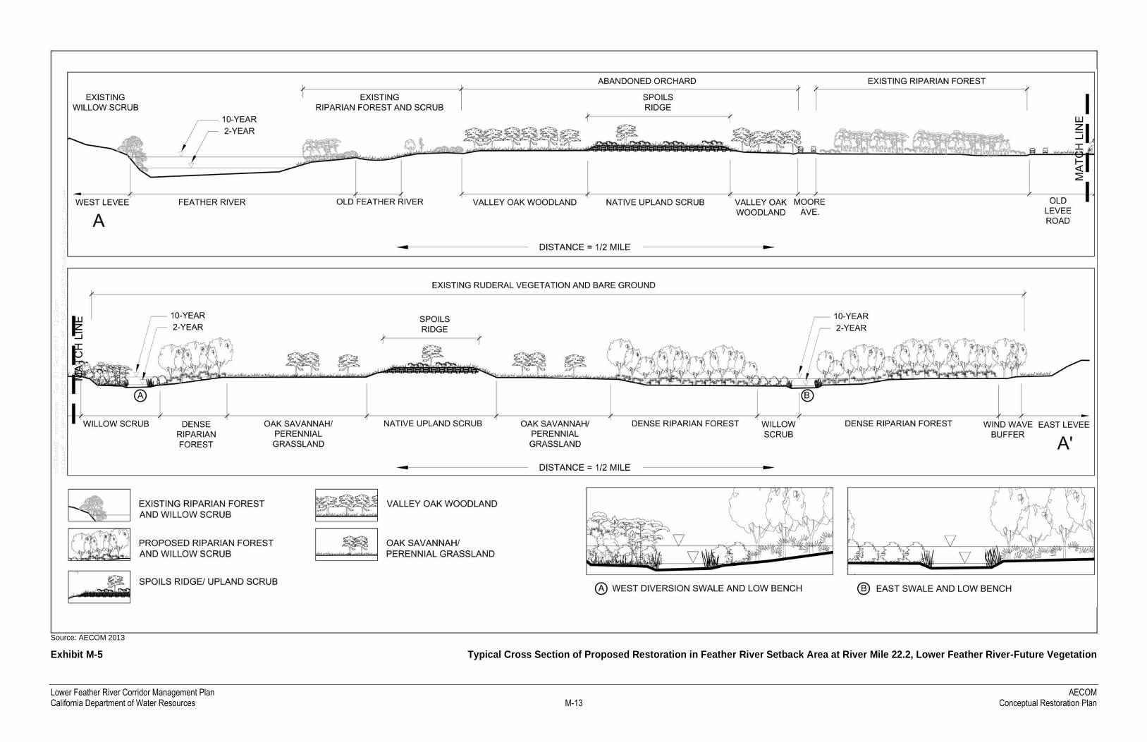
M.3.2 HYDRAULIC ROUGHNESS THRESHOLDS
Proposed restoration in the LFRCMP study area must be “flood-neutral”; that is, the hydraulic roughness of
planted trees and shrubs must not reduce the floodway’s design conveyance capacity or cause floodwater
elevation to increase above design standards. As described in Appendix B, “LFRCMP Flood Hydraulic Analysis
of Future Conditions,” MBK Engineers used a two-dimensional hydraulic computer model to assess the effects of
large flood events under both existing conditions in 2011 and proposed future conditions described in the
LFRCMP. This analysis simulated the effects of potential future conditions on water surface elevations, levee
freeboard, and velocity. The model calculates flow velocity, flow direction, and depth in 200-foot by 200-foot
cells across the entire floodway area between the levees. The modeler can change hydraulic roughness values in
each cell based on the type and density of vegetation (e.g., trees, shrubs, or grass). The results of each modeling
run reveal how the future vegetation would affect the direction of flow, its velocity, and its water surface
elevation. Exhibit M-6 depicts the maximum roughness thresholds that should not be exceeded for any planting
design proposed for the LFRCMP study area.
Lower Feather River Corridor Management Plan AECOM California Department of Water Resources M-11 Conceptual Restoration Plan
Source: AECOM 2013
Exhibit M-4 Location of Potential Future Restoration Projects in the LFRCMP Study Area

Lower Feather River Corridor Management Plan AECOM California Department of Water Resources M-13 Conceptual Restoration Plan
Source: AECOM 2013
Exhibit M-5 Typical Cross Section of Proposed Restoration in Feather River Setback Area at River Mile 22.2, Lower Feather River-Future Vegetation

Lower Feather River Corridor Management Plan AECOM California Department of Water Resources M-15 Conceptual Restoration Plan
Source: AECOM 2013, CBEC 2013
Exhibit M-6 Modeled Roughness Values for Future Vegetation at Proposed Restoration Sites in the LFRCMP Study Area

Lower Feather River Corridor Management Plan AECOM California Department of Water Resources M-17 Conceptual Restoration Plan
M.3.3 SOILS AND DEPTH TO GROUNDWATER
Soil conditions are a crucial determining factor in the survival and growth of restoration plantings and natural
colonization. Soil analysis conducted by TRLIA suggests that the FRS area supports conditions conducive to
riparian restoration, including deep soils with high moisture-holding capacity and few barriers to plant growth
(TRLIA 2013).
Depth to groundwater is also an important constraint in the survival and growth of riparian plantings. Depth to the
water table must be determined at several points across the proposed restoration sites using deep soil–auger cores
and soil pit samples, or with piezometers. Cottonwoods and willows must grow their roots into the upper portion
of the water table or capillary moisture zone within the 3- to 5-year maintenance period, or they may not survive
or thrive when irrigation is stopped.
With this need in mind, this Conceptual Restoration Plan has concentrated riparian planting sites at lower, more
frequently inundated elevations and in swales, and in valley oak woodland, native grassland, and upland scrub
plantings at higher elevations relative to the base-flow water surface. Absent any empirical information about
depth to groundwater, it is reasonably assumed that seasonal groundwater elevation is comparable to river stage in
adjacent channels.
M.3.4 NON-NATIVE INVASIVE PLANTS
Invasive plant species that degrade habitat quality and alter ecosystem processes have become especially abundant
in stream reaches where geomorphic processes have been disturbed. Dense stands of invasive species can alter
channel morphology by retaining sediments and increasing the channel’s hydraulic roughness, thereby restricting
flows and reducing flood conveyance (Bossard et al. 2000). Species with shallow root systems, such as giant reed
(Arundo) and red sesbania, promote bank undercutting, collapse, and erosion (Bossard et al. 2000). Invasive
plants can also reduce the integrity of native riparian and upland plant communities by outcompeting native plant
species and reducing habitat quality and food supply for invertebrates and wildlife (Bossard et al. 2000; Cal-IPC
2011).
Non-native invasive species such as giant reed, tree-of-heaven, perennial pepperweed, star thistle, and Himalayan
blackberry are established throughout the LFRCMP study area. Some of these species, particularly giant reed and
tree-of-heaven, can impede the flow of floodwaters and raise water surface elevations, and can capture sediment
and create depositional mounds. Tree-of-heaven forms clonal colonies that can take over native riparian plant
communities and may destabilize levee banks. Giant reed is highly flammable, increasing the risk of wildfire in
the corridor. Riparian tree species have a low tolerance of wildfire and may not recover naturally after a hot fire in
an understory of giant reed. All of these invasive species can alter the structure, function, and composition of
plant communities in riparian and adjacent habitats, and they compete with and displace native vegetation in the
LFRCMP study area. They also generally provide low-quality wildlife habitat.
M.3.5 HERBIVORES
Herbivory and stem girdling by deer, beavers, ground squirrels, pocket gophers, voles, rabbits, and hares can
adversely affect restoration efforts during the establishment phase that follows planting and seeding. Measures
such as cages and exclusion fencing can help control or minimize the effects of herbivores on young plants. In
AECOM Lower Feather River Corridor Management Plan Conceptual Restoration Plan M-18 California Department of Water Resources
addition, restoration sites are typically “overplanted” to allow for plant damage and loss by herbivores, without
affecting the overall success of the restoration project.
M.4 RESTORATION OBJECTIVES AND IMPLEMENTATION
M.4.1 HABITAT ENHANCEMENT FOR WILDLIFE
One of the primary objectives of the restoration activities described in this plan is to enhance habitat for special-
status wildlife species that currently occur or could potentially occur in the LFRCMP study area, and to promote
the general health and diversity of wildlife populations. Many studies have demonstrated the value to biological
diversity of the riparian and oak woodland habitats that are proposed for restoration.
More than 225 species of birds, mammals, reptiles, and amphibians depend on California’s riparian habitats, and
riparian ecosystems support the most diverse bird communities in the arid and semiarid portions of the western
United States (RHJV 2004). Increasing the expanse of riparian habitat in the LFRCMP study area would certainly
enhance the area’s overall habitat value to many species. Specifically, such an increase would help to achieve the
optimal goal of protecting and restoring riparian habitat in patches collectively totaling more than 1,200 acres
within a river reach, to promote conditions suitable for western yellow-billed cuckoo (RHJV 2004).
Recent studies have highlighted the importance of the Sacramento Valley population of western yellow-billed
cuckoo to its recovery in California. Continued efforts to restore riparian habitat and the river processes that
maintain them are needed to aid cuckoo recovery (Dettling and Howell 2011). Although no cuckoos were
documented in the study area during focused surveys conducted in 2012 (Dettling and Seavy 2013), they have
occurred in the past. In addition, the number and locations of cuckoo detections are known to fluctuate
considerably between years in areas with known breeding populations.
Other neotropical migrant birds that nest in the region, such as black-headed grosbeak, blue grosbeak, yellow-
breasted chat, and yellow warbler, would benefit from restoration of structurally complex areas of riparian forest
and scrub. These habitats are also preferred by least Bell’s vireo. Although this species had not nested in the
Central Valley for the previous 50 years, least Bell’s vireos have nested in recently restored riparian habitat at the
San Joaquin River National Wildlife Refuge in recent years, and breeding populations in Southern California have
increased considerably in recent decades. This subspecies may continue to expand northward and reoccupy
additional areas from which it has been extirpated. These vireos prefer dense shrubby vegetation that tends to mature
into taller forests with a less dense, less desirable understory. Therefore, ecologists have highlighted the importance
of riparian restoration designs that promote a thick understory, management that promotes understory growth, and
restoration of natural processes (e.g., flooding) that promote growth of new vegetation (Howell et al. 2010). Such
restoration and management approaches would also benefit many additional bird species and other wildlife.
Like riparian habitat, oak woodlands proposed for restoration in the LFRCMP study area are used by a wide
variety of species. These woodlands have the richest wildlife-species abundance of any habitat in California; more
than 330 species of birds, mammals, reptiles, and amphibians depend on them at some stage in their life cycle
(CalPIF and PRBO 2002). Wilson and others (1991) have suggested that California oak woodlands rank among
the top three habitat types in North America for bird species richness. These habitats can sustain such high
wildlife diversity and abundance largely because they produce acorns. Acorns are a very high-quality food type
that, in turn, supports an abundant and diverse community of invertebrates and other species that depend on the

Lower Feather River Corridor Management Plan AECOM California Department of Water Resources M-19 Conceptual Restoration Plan
acorns and invertebrates for food. Oak woodlands also provide important sheltering and breeding habitat for a
wide variety of reptiles, amphibians, and mammals.
The proposed target upland habitats would also provide foraging habitat for Swainson’s hawk and numerous other
species. Tall sycamore, cottonwood, and valley oak trees in riparian forest and oak woodlands would provide
nesting and perching sites for Swainson’s hawk, Cooper’s hawk, white-tailed kite, and other raptors. Wide-
ranging mammals such as grey fox, Sacramento valley red fox, and black-tailed deer would benefit from the
increased connectivity of riparian forest/scrub, oak woodland, and native upland scrub. In addition, creating high
ridges with material excavated from swales would provide wildlife refugia for terrestrial species during flood
events that otherwise would inundate all natural habitat within the floodway. These artificial upland areas would
have relatively arid soil conditions, and would therefore be vegetated with grassland, scrub, and scattered oaks
that provide food and cover for a variety of wildlife species.
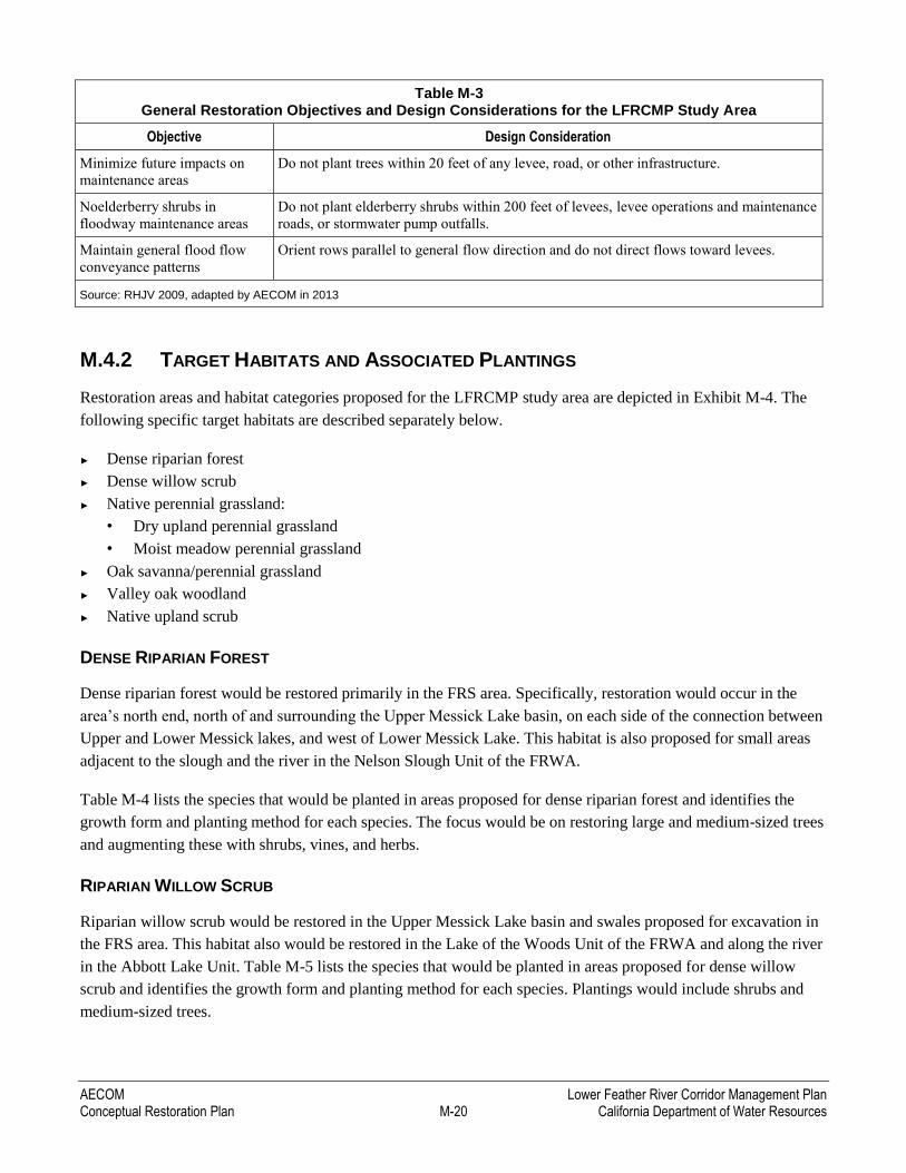
Table M-3 outlines overall restoration objectives for diverse plant and wildlife species, vegetation, and habitats;
for floodway maintenance activities; and for flood flow conveyance. The table also provides some corresponding
design considerations to help achieve these objectives.
Table M-3 General Restoration Objectives and Design Considerations for the LFRCMP Study Area
Objective Design Consideration
Maintain high structural
diversity of plant species and
vegetation
Vary density across the site to allow light gaps and create structural differences (grouping
trees creates pockets of shade and light gaps); create vegetation patches (grouping small
shrubs together mimics larger plants and may attract desirable wildlife species faster than if
they are grown apart); and consider herbaceous plantings between plant rows. Bird diversity
is highest in areas with five to seven shrub species over an area of 50 square meters.
Provide immediate (< 3 years)
habitat benefits
In the short term, use relatively transient species (cottonwood and arroyo willow) to
provide several generations of targeted bird species with nesting and foraging habitat.
Planting a mixed riparian forest maximizes quality habitat as the slow-growing but shade-
tolerant oaks mature. Coyote brush, rose, elderberry, and blackberry grow quickly and
create habitat for quail and many neotropical migrants.
Create migratory and
nesting/roosting corridor for
yellow-billed cuckoo
Plant a high density of cottonwood and sycamore trees within a 300-foot-wide mixed
riparian plant community.
Provide foraging and nesting
sites for Swainson’s hawk
Plant tall riparian trees to provide nesting and perching areas for Swainson’s hawks and
other raptors and perennial grassland to provide foraging habitat.
Seek opportunities to promote
natural riverine processes and
development of SRA habitat
and bank swallow nesting
habitat
Evaluate the feasibility of revetment removal in areas where bank protection is no longer
deemed necessary, in order to promote restoration of natural riverine processes and habitat
(SRA habitat and bank swallow nesting sites).
Minimize sources of weeds;
provide habitat along project
edges
Use native plants to displace weeds in areas outside the main plantable area. Use spreading
plants and native understory species to outcompete invasive species that currently grow
on-site.
Provide foraging, roosting, and
nesting habitat for neotropical
migrant and riparian-dependent
bird species
Plant dense shrub clusters to provide cover for roosting and protection from predators.
Annual vegetation provides foraging habitat for seed eaters, a dense and open mixed
riparian plant community and valley oak riparian forest provides habitat for woodland
species, and native grasslands provide habitat for species that utilize open landscapes.
AECOM Lower Feather River Corridor Management Plan Conceptual Restoration Plan M-20 California Department of Water Resources
Table M-3 General Restoration Objectives and Design Considerations for the LFRCMP Study Area
Objective Design Consideration
Minimize future impacts on
maintenance areas
Do not plant trees within 20 feet of any levee, road, or other infrastructure.
Noelderberry shrubs in
floodway maintenance areas
Do not plant elderberry shrubs within 200 feet of levees, levee operations and maintenance
roads, or stormwater pump outfalls.
Maintain general flood flow
conveyance patterns
Orient rows parallel to general flow direction and do not direct flows toward levees.
Source: RHJV 2009, adapted by AECOM in 2013
M.4.2 TARGET HABITATS AND ASSOCIATED PLANTINGS
Restoration areas and habitat categories proposed for the LFRCMP study area are depicted in Exhibit M-4. The
following specific target habitats are described separately below.
► Dense riparian forest
► Dense willow scrub
► Native perennial grassland:
• Dry upland perennial grassland
• Moist meadow perennial grassland
► Oak savanna/perennial grassland
► Valley oak woodland
► Native upland scrub
DENSE RIPARIAN FOREST
Dense riparian forest would be restored primarily in the FRS area. Specifically, restoration would occur in the
area’s north end, north of and surrounding the Upper Messick Lake basin, on each side of the connection between
Upper and Lower Messick lakes, and west of Lower Messick Lake. This habitat is also proposed for small areas
adjacent to the slough and the river in the Nelson Slough Unit of the FRWA.
Table M-4 lists the species that would be planted in areas proposed for dense riparian forest and identifies the
growth form and planting method for each species. The focus would be on restoring large and medium-sized trees
and augmenting these with shrubs, vines, and herbs.
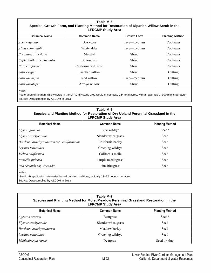
RIPARIAN WILLOW SCRUB
Riparian willow scrub would be restored in the Upper Messick Lake basin and swales proposed for excavation in
the FRS area. This habitat also would be restored in the Lake of the Woods Unit of the FRWA and along the river
in the Abbott Lake Unit. Table M-5 lists the species that would be planted in areas proposed for dense willow
scrub and identifies the growth form and planting method for each species. Plantings would include shrubs and
medium-sized trees.
Lower Feather River Corridor Management Plan AECOM California Department of Water Resources M-21 Conceptual Restoration Plan
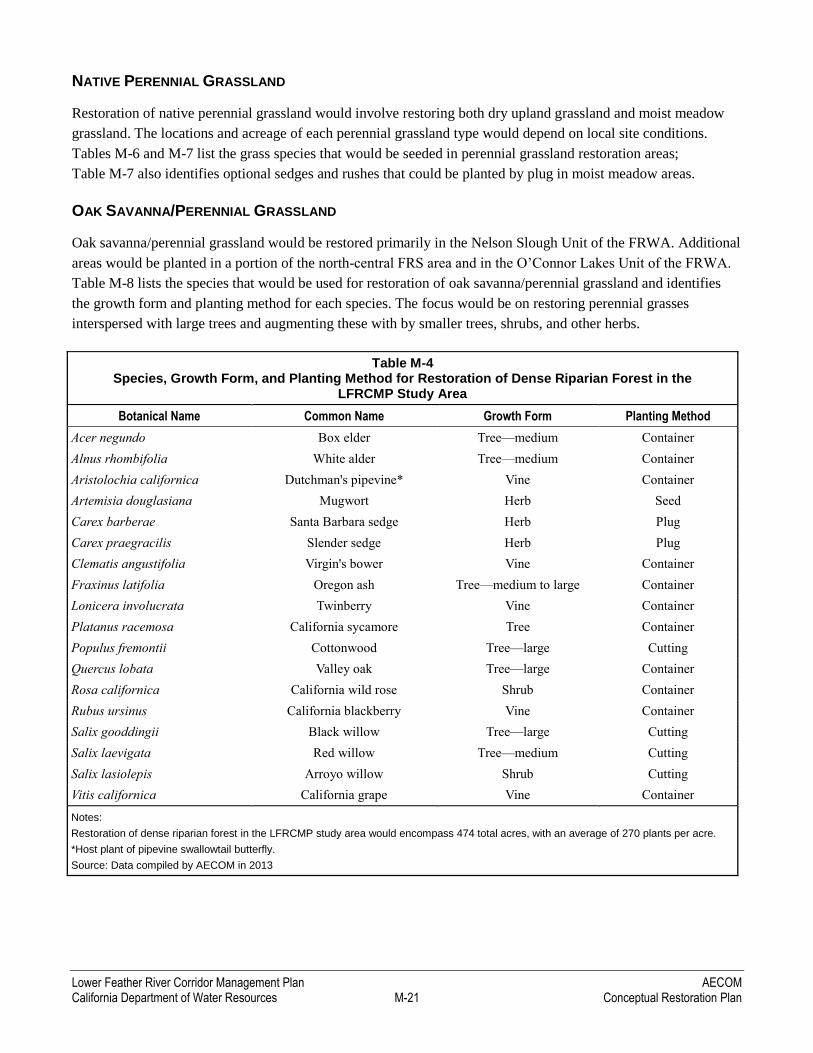
NATIVE PERENNIAL GRASSLAND
Restoration of native perennial grassland would involve restoring both dry upland grassland and moist meadow
grassland. The locations and acreage of each perennial grassland type would depend on local site conditions.
Tables M-6 and M-7 list the grass species that would be seeded in perennial grassland restoration areas;
Table M-7 also identifies optional sedges and rushes that could be planted by plug in moist meadow areas.
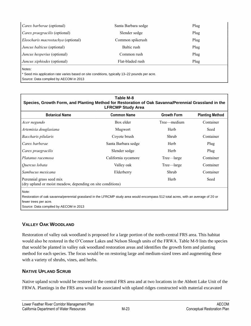
OAK SAVANNA/PERENNIAL GRASSLAND
Oak savanna/perennial grassland would be restored primarily in the Nelson Slough Unit of the FRWA. Additional
areas would be planted in a portion of the north-central FRS area and in the O’Connor Lakes Unit of the FRWA.
Table M-8 lists the species that would be used for restoration of oak savanna/perennial grassland and identifies
the growth form and planting method for each species. The focus would be on restoring perennial grasses
interspersed with large trees and augmenting these with by smaller trees, shrubs, and other herbs.
Table M-4 Species, Growth Form, and Planting Method for Restoration of Dense Riparian Forest in the
LFRCMP Study Area
Botanical Name Common Name Growth Form Planting Method
Acer negundo Box elder Tree—medium Container
Alnus rhombifolia White alder Tree—medium Container
Aristolochia californica Dutchman's pipevine* Vine Container
Artemisia douglasiana Mugwort Herb Seed
Carex barberae Santa Barbara sedge Herb Plug
Carex praegracilis Slender sedge Herb Plug
Clematis angustifolia Virgin's bower Vine Container
Fraxinus latifolia Oregon ash Tree—medium to large Container
Lonicera involucrata Twinberry Vine Container
Platanus racemosa California sycamore Tree Container
Populus fremontii Cottonwood Tree—large Cutting
Quercus lobata Valley oak Tree—large Container
Rosa californica California wild rose Shrub Container
Rubus ursinus California blackberry Vine Container
Salix gooddingii Black willow Tree—large Cutting
Salix laevigata Red willow Tree—medium Cutting
Salix lasiolepis Arroyo willow Shrub Cutting
Vitis californica California grape Vine Container
Notes:
Restoration of dense riparian forest in the LFRCMP study area would encompass 474 total acres, with an average of 270 plants per acre.
*Host plant of pipevine swallowtail butterfly.
Source: Data compiled by AECOM in 2013
AECOM Lower Feather River Corridor Management Plan Conceptual Restoration Plan M-22 California Department of Water Resources
Table M-5 Species, Growth Form, and Planting Method for Restoration of Riparian Willow Scrub in the
LFRCMP Study Area
Botanical Name Common Name Growth Form Planting Method
Acer negundo Box elder Tree—medium Container
Alnus rhombifolia White alder Tree—medium Container
Baccharis salicifolia Mulefat Shrub Container
Cephalanthus occidentalis Buttonbush Shrub Container
Rosa californica California wild rose Shrub Container
Salix exigua Sandbar willow Shrub Cutting
Salix laevigata Red willow Tree—medium Cutting
Salix lasiolepis Arroyo willow Shrub Cutting
Notes:
Restoration of riparian willow scrub in the LFRCMP study area would encompass 264 total acres, with an average of 300 plants per acre.
Source: Data compiled by AECOM in 2013
Table M-6 Species and Planting Method for Restoration of Dry Upland Perennial Grassland in the
LFRCMP Study Area
Botanical Name Common Name Planting Method
Elymus glaucus Blue wildrye Seed*
Elymus trachycaulus Slender wheatgrass Seed
Hordeum brachyantherum ssp. californicum California barley Seed
Leymus triticoides Creeping wildrye Seed
Melica californica California melic Seed
Nassella pulchra Purple needlegrass Seed
Poa secunda ssp. secunda Pine bluegrass Seed
Notes:
*Seed mix application rate varies based on site conditions, typically 13–22 pounds per acre.
Source: Data compiled by AECOM in 2013
Table M-7 Species and Planting Method for Moist Meadow Perennial Grassland Restoration in the
LFRCMP Study Area
Botanical Name Common Name Planting Method
Agrostis exarata Bentgrass Seed*
Elymus trachycaulus Slender wheatgrass Seed
Hordeum brachyantherum Meadow barley Seed
Leymus triticoides Creeping wildrye Seed
Muhlenbergia rigens Deergrass Seed or plug
Lower Feather River Corridor Management Plan AECOM California Department of Water Resources M-23 Conceptual Restoration Plan
Carex barberae (optional) Santa Barbara sedge Plug
Carex praegracilis (optional) Slender sedge Plug
Eleocharis macrostachya (optional) Common spikerush Plug
Juncus balticus (optional) Baltic rush Plug
Juncus hesperius (optional) Common rush Plug
Juncus xiphiodes (optional) Flat-bladed rush Plug
Notes:
* Seed mix application rate varies based on site conditions, typically 13–22 pounds per acre.
Source: Data compiled by AECOM in 2013
Table M-8 Species, Growth Form, and Planting Method for Restoration of Oak Savanna/Perennial Grassland in the
LFRCMP Study Area
Botanical Name Common Name Growth Form Planting Method
Acer negundo Box elder Tree—medium Container
Artemisia douglasiana Mugwort Herb Seed
Baccharis pilularis Coyote brush Shrub Container
Carex barberae Santa Barbara sedge Herb Plug
Carex praegracilis Slender sedge Herb Plug
Platanus racemosa California sycamore Tree—large Container
Quercus lobata Valley oak Tree—large Container
Sambucus mexicana Elderberry Shrub Container
Perennial grass seed mix
(dry upland or moist meadow, depending on site conditions)
Herb Seed
Note:
Restoration of oak savanna/perennial grassland in the LFRCMP study area would encompass 512 total acres, with an average of 20 or
fewer trees per acre.
Source: Data compiled by AECOM in 2013
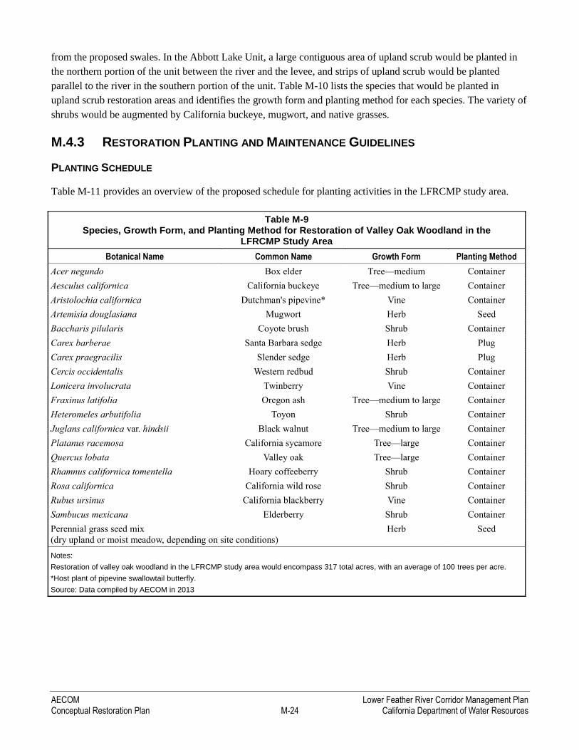
VALLEY OAK WOODLAND
Restoration of valley oak woodland is proposed for a large portion of the north-central FRS area. This habitat
would also be restored in the O’Connor Lakes and Nelson Slough units of the FRWA. Table M-9 lists the species
that would be planted in valley oak woodland restoration areas and identifies the growth form and planting
method for each species. The focus would be on restoring large and medium-sized trees and augmenting these
with a variety of shrubs, vines, and herbs.
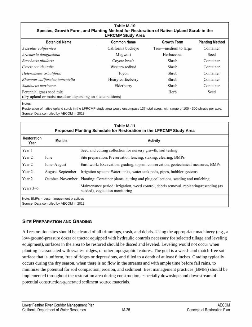
NATIVE UPLAND SCRUB
Native upland scrub would be restored in the central FRS area and at two locations in the Abbott Lake Unit of the
FRWA. Plantings in the FRS area would be associated with upland ridges constructed with material excavated
AECOM Lower Feather River Corridor Management Plan Conceptual Restoration Plan M-24 California Department of Water Resources
from the proposed swales. In the Abbott Lake Unit, a large contiguous area of upland scrub would be planted in
the northern portion of the unit between the river and the levee, and strips of upland scrub would be planted
parallel to the river in the southern portion of the unit. Table M-10 lists the species that would be planted in
upland scrub restoration areas and identifies the growth form and planting method for each species. The variety of
shrubs would be augmented by California buckeye, mugwort, and native grasses.
M.4.3 RESTORATION PLANTING AND MAINTENANCE GUIDELINES
PLANTING SCHEDULE
Table M-11 provides an overview of the proposed schedule for planting activities in the LFRCMP study area.
Table M-9 Species, Growth Form, and Planting Method for Restoration of Valley Oak Woodland in the
LFRCMP Study Area
Botanical Name Common Name Growth Form Planting Method
Acer negundo Box elder Tree—medium Container
Aesculus californica California buckeye Tree—medium to large Container
Aristolochia californica Dutchman's pipevine* Vine Container
Artemisia douglasiana Mugwort Herb Seed
Baccharis pilularis Coyote brush Shrub Container
Carex barberae Santa Barbara sedge Herb Plug
Carex praegracilis Slender sedge Herb Plug
Cercis occidentalis Western redbud Shrub Container
Lonicera involucrata Twinberry Vine Container
Fraxinus latifolia Oregon ash Tree—medium to large Container
Heteromeles arbutifolia Toyon Shrub Container
Juglans californica var. hindsii Black walnut Tree—medium to large Container
Platanus racemosa California sycamore Tree—large Container
Quercus lobata Valley oak Tree—large Container
Rhamnus californica tomentella Hoary coffeeberry Shrub Container
Rosa californica California wild rose Shrub Container
Rubus ursinus California blackberry Vine Container
Sambucus mexicana Elderberry Shrub Container
Perennial grass seed mix
(dry upland or moist meadow, depending on site conditions)
Herb Seed
Notes:
Restoration of valley oak woodland in the LFRCMP study area would encompass 317 total acres, with an average of 100 trees per acre.
*Host plant of pipevine swallowtail butterfly.
Source: Data compiled by AECOM in 2013
Lower Feather River Corridor Management Plan AECOM California Department of Water Resources M-25 Conceptual Restoration Plan
Table M-10 Species, Growth Form, and Planting Method for Restoration of Native Upland Scrub in the
LFRCMP Study Area
Botanical Name Common Name Growth Form Planting Method
Aesculus californica California buckeye Tree—medium to large Container
Artemesia douglasiana Mugwort Herbaceous Seed
Baccharis pilularis Coyote brush Shrub Container
Cercis occidentalis Western redbud Shrub Container
Heteromeles arbutifolia Toyon Shrub Container
Rhamnus californica tomentella Hoary coffeeberry Shrub Container
Sambucus mexicana Elderberry Shrub Container
Perennial grass seed mix
(dry upland or moist meadow, depending on site conditions)
Herb Seed
Notes:
Restoration of native upland scrub in the LFRCMP study area would encompass 137 total acres, with range of 100 - 300 shrubs per acre.
Source: Data compiled by AECOM in 2013
Table M-11 Proposed Planting Schedule for Restoration in the LFRCMP Study Area
Restoration Year
Months Activity
Year 1 Seed and cutting collection for nursery growth; soil testing
Year 2 June Site preparation: Preservation fencing, staking, clearing, BMPs
Year 2 June–August Earthwork: Excavation, grading, topsoil conservation, geotechnical measures, BMPs
Year 2 August–September Irrigation system: Water tanks, water tank pads, pipes, bubbler systems
Year 2 October–November Planting: Container plants, cutting and plug collections, seeding and mulching
Years 3–6 Maintenance period: Irrigation, weed control, debris removal, replanting/reseeding (as
needed), vegetation monitoring
Note: BMPs = best management practices
Source: Data compiled by AECOM in 2013
SITE PREPARATION AND GRADING
All restoration sites should be cleared of all trimmings, trash, and debris. Using the appropriate machinery (e.g., a
low-ground-pressure dozer or tractor equipped with hydraulic controls necessary for selected tillage and leveling
equipment), surfaces in the area to be restored should be disced and leveled. Leveling would not occur when
planting is associated with swales, ridges, or other topographic features. The goal is a weed- and thatch-free soil
surface that is uniform, free of ridges or depressions, and tilled to a depth of at least 6 inches. Grading typically
occurs during the dry season, when there is no flow in the streams and with ample time before fall rains, to
minimize the potential for soil compaction, erosion, and sediment. Best management practices (BMPs) should be
implemented throughout the restoration area during construction, especially downslope and downstream of
potential construction-generated sediment source materials.

AECOM Lower Feather River Corridor Management Plan Conceptual Restoration Plan M-26 California Department of Water Resources
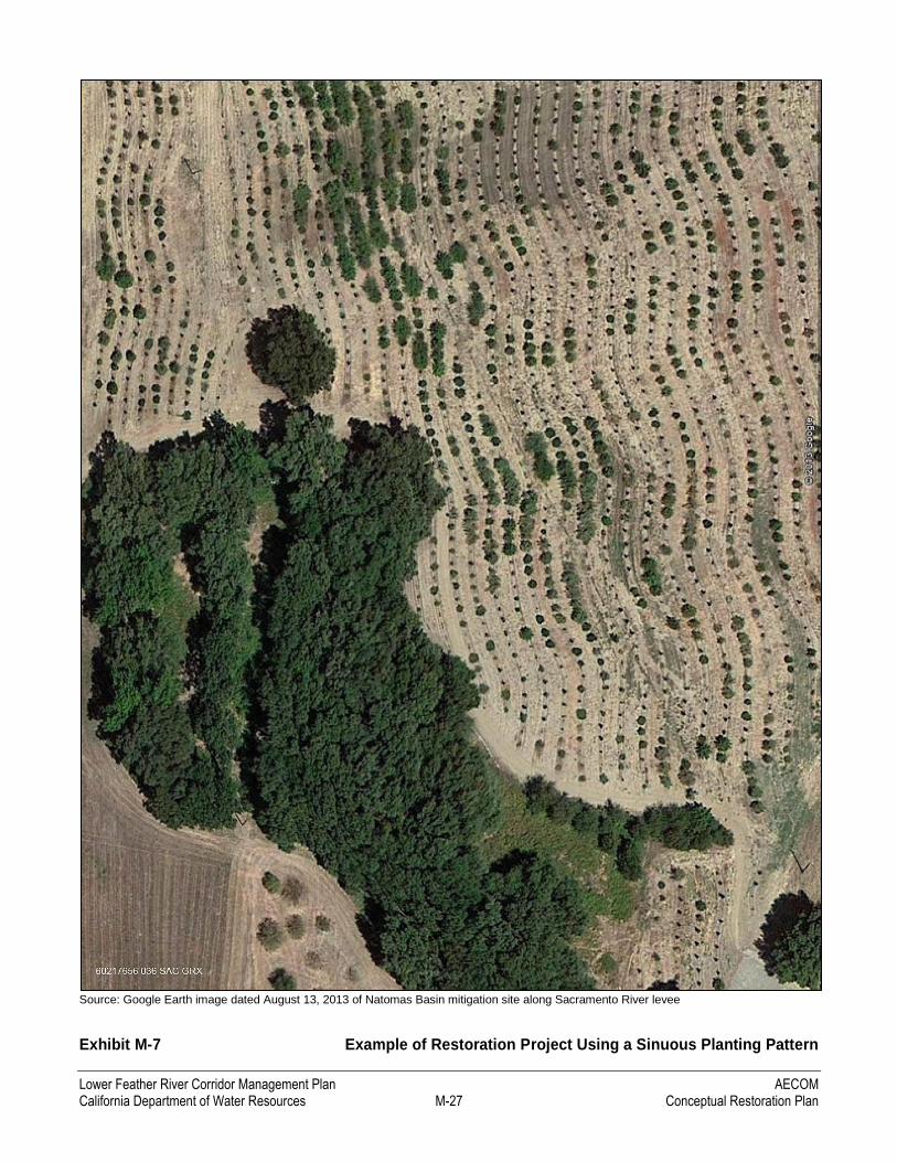
For most vegetation types, plant layout would be based on pulled planting berms running in curving, sinuous rows
parallel to flood flows (Exhibit M-7). This method helps create a more natural layout and avoid an orchard-like
appearance over time. Pulled planting berms are created using angled twin disc blades pulled along predetermined
centerline locations. Dimensions, locations, orientation, and sinuosity would be determined based on site conditions.
HORTICULTURAL SOIL TESTING
Soil testing is a critical step in designing and implementing a successful restoration program because soil toxicity
or incompatibility problems such as excessive salinity or alkalinity, the overabundance of certain elements such as
magnesium, or low soil nutrition cannot be readily determined in the absence of agricultural suitability tests. If
left undetected, these problems have the potential to result in widespread plant mortality or poor growth
performance. The primary goals of soil testing are to finalize the planting lists, identify difficult soils and possible
soil treatments, detect variation in the soils throughout the site, and determine agricultural regimes during
establishment maintenance.
Soil analysis reveals several chemical and physical characteristics, such as salinity, pH, fertility, and permeability.
Understanding these characteristics of the native soils provides a “restoration template” and assists in selection of
an appropriate plant palette. Recommendations for soil amendments and improvements in soil conditions may
correct for pH or fertility problems or may improve permeability. However, certain soil conditions should dictate
changing the plants used rather than the soils themselves, if the soils support a unique plant community.
PRE-PLANTING WEED MANAGEMENT
The purpose, methods, and timing of weed management are designed to remove weed species that threaten the
establishment of native species to be planted or can displace those native species, and to prevent the dispersal of
weed seed by killing weeds before flowering or development of viable seed. Invasive exotics that are allowed to
become established frequently require repeated control efforts.
Weed control in the restoration areas should follow an Integrated Pest Management (IPM) approach. IPM is a
decision-making and management process that uses knowledge from a broad base of expertise, a combination of
treatment methods, and a monitoring and evaluation system to solve pest problems in an environmentally sound
and cost-effective manner. IPM programs emphasize preventing weeds by using knowledge about the biology and
behavior of weed species to identify and remove the conditions that support weeds.
A wide array of methods are available for weed biomass control: physical/mechanical control (e.g., mowing,
discing, brush cutting, hand pulling), biological controls (e.g., grazing, insect parasites), other control methods
(e.g., prescribed burns, use of a flaming device), and in some cases localized application of herbicides (chemical
control). Mechanical, manual, and grazing methods of eradicating exotic species should take precedence over
chemical eradication. When needed, herbicides should be used in conjunction with physical and/or mechanical or
other non-chemical methods, rather than being used as the sole management tool. This integrated approach helps
to minimize use of herbicides in the long term; it also enhances the efficacy of the lowest risk chemical products
and formulations because they are augmented with other methods. After plants have been installed, spot
treatments rather than broadcast sprays are preferred to limit or avoid impacts on non-target organisms.
Lower Feather River Corridor Management Plan AECOM California Department of Water Resources M-27 Conceptual Restoration Plan
Source: Google Earth image dated August 13, 2013 of Natomas Basin mitigation site along Sacramento River levee
Exhibit M-7 Example of Restoration Project Using a Sinuous Planting Pattern
AECOM Lower Feather River Corridor Management Plan Conceptual Restoration Plan M-28 California Department of Water Resources
Species-specific weed control recommendations should be developed for invasive exotics that require control in
restoration areas. These recommendations should take into account weed characteristics such as flowering time,
life form, and germination period, as well as common proven control methods. Grazing, mowing, prescribed
burning, and chemical treatment are discussed below as they pertain to weed-control efforts.
Grazing
Small-hoofed animals, such as sheep or goats, can be used to manage upland and wetland vegetation and suppress
the proliferation of postplanting weed populations. Grazing techniques can be used to either trim vegetation tops
(similar to mowing) or remove vegetation more thoroughly (similar to burning). Grazing may also be employed to
remove aquatic vegetation if a ditch or seasonal swale is dewatered.
Grazing for control of noxious weeds should typically occur in spring, after the dominant noxious weed species
have flowered but before they have set seed. Preferred timing varies depending on weather conditions, and should
be based on field observations. Grazing should not occur between May 1 and July 1 to allow native perennial
grasses to set seed. Grazing to control vegetation height should occur between July 1 and October 1.
The use of grazing animals should be evaluated to ensure that hoofed animals are not causing bank erosion,
excessive browsing or girdling of woody plants, or damage to perennial grassland cover.
Mowing
Mowing can be used to control vegetation height and excessive biomass, and to discourage the spread of noxious
broad-leaved weeds. Mowing would be conducted with a wheeled tractor with boom-mounted flail mower and/or
a rear-attached flail mower, or a with a self-contained riding-type mower. All mowers should be equipped with
height gauges set to leave the remaining vegetation approximately 6–12 inches tall, except for access roads where
vegetation can be cut to leave the access roads clean of cover.
Mowing for control of noxious weeds should typically occur in spring, after the dominant noxious weed species
have flowered but before they have set seed. Preferred timing varies depending on weather and soil conditions,
and should be based on field observations. Mowing generally should not occur between May 1 and July 1 to allow
native perennial grasses to set seed, unless controlling noxious weeds or reducing fire-hazard biomass is a high
priority. Mowing to control vegetation height should typically occur between July 1 and October 1.
Prescribed Burning
Prescribed burning is the practice of using controlled fires to reduce or eliminate unwanted organic matter in
grasslands and ruderal vegetation areas. If conditions are conducive and safe (e.g., favorable wind conditions,
vegetation moisture content, and sufficient fuel material), burning has been shown to be effective in reducing
organic matter (i.e., thatch), broad-leaved weeds, and annual grasses, and in promoting growth of native perennial
grasses.
Prescribed burning should occur infrequently, primarily to control thatch buildup, if not adequately controlled
with other vegetation management methods. Prescribed burning must be conducted in coordination with the local
fire district and in accordance with all laws and local ordinances. Timing of prescribed burns should take into
account the habits of protected and other native wildlife species.
Lower Feather River Corridor Management Plan AECOM California Department of Water Resources M-29 Conceptual Restoration Plan
Chemical Treatment
Use of contact, pre-emergent, and systemic herbicides can be valuable and highly effective in suppressing
terrestrial weedy plants. Selective herbicides can be used instead of broad-spectrum herbicides that may cause
mortality of desirable vegetation. Herbicides may be used before planting to eliminate weeds and weed seeds present
in the soil. The type and timing of herbicide application must be selected to prevent herbicide persistence in the soil
and any adverse effect on woodland plantings and germination of native grass seedlings.
PLANT AND SEED PROCUREMENT
The plant species listed in Tables M-4 through M-10 are native to the region and have been carefully selected for
the habitats to be created. When properly planted and cared for, these species offer the best chance of successful
establishment in the absence of permanent irrigation. Therefore, only these or other carefully considered native
species should be used in restoration projects.
To preserve ecotype differences of local native plant populations, local sources of container plants, cuttings,
plugs, and seed should be used to the greatest extent feasible. A lead time of 12–18 months is required from time
of seed or cutting collection to transplant maturity for plants grown in containers at a nursery. Suppliers and
nurseries providing stock should certify the origin of their source material.
Care should be taken to protect plants from wind, heat, and other conditions that can damage or impair viability,
both during delivery and when temporarily stored on-site before planting. Once transported to the planting site,
container stock should be planted promptly unless properly protected and irrigated.
SOIL PREPARATION
Planting areas must be thoroughly wetted to settle the soil and confirm irrigation coverage and operation before
planting. The soil would then be allowed to dry to render it workable. Seeded planting areas are typically tilled to
a depth of 6 inches or greater, in two directions, before planting operations begin. Should restoration activities
encounter large rocks, roots of existing trees, or other underground obstructions that interfere with excavation for
plants, or should clay-based areas be encountered that are not acceptable for good root growth, a restoration
ecologist may need to modify the planting plans for affected areas in the field.
SEEDING TECHNIQUES
Planting should begin in the fall to early winter, once rains have “flushed” winter weeds; herbicides should be
applied just before planting to kill sprouting winter weeds. Several seeding methods—drill seeding, broadcast
seeding, hydroseeding, and ridge-roller-seeding—are available for seed application. Using either a ridge-roller-
seeder or a native-grass seed drill (e.g., Truax Grass Drill) with supplemental surface preparation is the
recommended method for seeding uplands.
A ridge-roller-seeder is a specialized type of seeding equipment similar to a typical rice roller. Seed is typically
drilled in rows at a maximum distance of 8 inches apart and to a depth of 1⁄2 to 1 inch. In areas that are too
constricted to operate a grass seed drill, mechanical broadcast seeding is recommended. Following broadcast
seeding, the seed must be worked into the soil surface by hand raking or lightly harrowing and the seed must be
AECOM Lower Feather River Corridor Management Plan Conceptual Restoration Plan M-30 California Department of Water Resources
covered with adjacent soil to a 1/4-inch depth. A light-duty ring roller or Fuerst tine harrow or equivalent is used
after broadcast seeding, or is attached to the seeder, to ensure light soil coverage of broadcast seed.
Areas to be seeded near and within the driplines of existing vegetation to remain or of recently planted shrubs or
trees should be seeded by hand and these areas should be hand-raked to cover the seeds and avoid damaging the
root zone, the trunk, or any vegetation to remain. Upon completion of seeding, certified weed-free straw mulch
can be blown or spread by hand, as appropriate, then "tucked in" or anchored into the soil.
LOCAL PLUG COLLECTION AND PLANTING TECHNIQUES
Plug salvage/collection and planting should occur in the fall, concurrent with other planting activities. Sedges and
rushes typically can be planted at the edges of perennial waters well into the summer, but this is ultimately
dependent on specific site characteristics.
Planting can be accomplished using a long-handled dibble for smaller plugs, or trowels or shovels for larger
plugs. Holes dug for the plugs should be only slightly larger than the plugs, and the sides and bottoms of holes
should not be compacted. When backfilling the planting hole with native soil, care must be taken to remove all air
pockets. Ensuring that the plug roots are in contact with the soil and completely covered is critical to making
certain that the plugs will not dry out. The plugs should be thoroughly watered-in on the day they are planted.
Irrigation may be required to keep the transplanted plugs alive, especially through the first summer season.
CONTAINER PLANTING TECHNIQUES
For optimal results, planting should be done when the soil is moist to a depth of 12 inches, usually after the first
fall rains. Alternatively, plant locations must be watered for a minimum of 8 hours immediately before plant
installation. In a normal season, November is the preferred month for planting. The physiological state of the
plants is optimal during the fall and winter; therefore, adhering to appropriate planting schedules enhances
restoration success. Furthermore, planting during the fall drastically reduces the need for supplemental irrigation
because roots have more time to develop before aboveground shoot growth begins.
Before plants are installed, the irrigation system must be installed and any weeds that have sprouted since clearing
operations should be removed by mechanical or manual methods within a 48-inch radius of individual planting
sites and disposed of off-site. These weeds would otherwise compete for moisture and sunlight critical to the
establishing plants.
Restoration drawings and specifications should be organized by planting zone and should include plant name,
container type and size (e.g. Treepot4, Deepot, and Tree Band), spacing, quantity of each plant species, and year
to be installed. Plants should be set out on the same day they are to be planted. Nurseries that specialize in plants
for large-scale restoration projects typically offer relatively small plants grown in containers that are longer than
the width of the container to accommodate deeper roots, minimize irrigation dependency, and promote root soil
exploration.
The locations of individual plantings along the pulled planting berms should be field marked (e.g., painted, staked
or flagged) by plant species. Plants are installed in the center of pulled planting berms, typically in a linear
spacing of between 10 and 20 feet on-center. Plants are laid out at a typical density shown on the plan set, and are
located somewhat irregularly in clusters by species to avoid an orchard-like appearance and to mimic a natural
Lower Feather River Corridor Management Plan AECOM California Department of Water Resources M-31 Conceptual Restoration Plan
layout (Exhibit M-8). Plants should not be located too close to access roads, staging locations, mowed perimeters,
irrigation ditches, utility corridors, or other known exclusion areas.
Soil preparation is intended to expand and improve the rooting area for each plant by decompacting (aerating) the
soil at individual planting sites. Planting pits may be excavated using one or more methods such as hand digging
and using a pry bar, hydraulic bar, and/or auger. Planting holes are typically dug to a depth of 18 inches by
24 inches wide, then are backfilled with native soil free of amendments up to the level of the rootball. Each plant
is placed in the planting hole and the hole is filled with moist, pulverized backfill, which is then tamped and
watered. The plant is positioned with the root crown set no more than ½ inch above grade at the time of planting,
and is covered with a maximum of 1⁄4 inch of backfill. Backfill material should be firmly packed in place and
should make good contact with the rootball, leaving no air pockets. Additional fill may be required in case of soil
settlement.
Watering basins, which eventually settle and erode, may be necessary to prevent water from running off. These
basins around individual plants typically measure 4 inches high and 36 inches in diameter, or are created using
pulled berms and parallel irrigation gutters as shown in Exhibit M-8. Planting techniques on slopes differ slightly
from planting techniques on level ground. To accommodate slope plantings, a small planting terrace is excavated
approximately 20 inches wide and 15 inches deep and sloped slightly to the hill. A 4-inch berm is built on the
open side to collect water. At the time of planting, all watering basins should be filled to capacity to check for soil
berm stability and basin drainage. Basins are not necessary for live willow cuttings.
Plant protection cages or tubes must be installed around all container-grown shrubs and trees at the time of
planting, and all plants must be watered thoroughly regardless of soil moisture conditions.
CUTTING COLLECTION AND PLANTING
Cuttings collected from willow and cottonwood donor plants should be collected from various representative
sources in the vicinity of the restoration site to preserve the genetic diversity and viability of the cuttings. Cutting
materials are harvested when the trees are dormant, typically during January and February, from green wood that
is disease free and healthy, with a maximum of 1 year of growth. The source-plant collection area must be able to
physically and visually recover to undisturbed conditions within a reasonable period. Live cuttings of willow and
cottonwood should be a minimum of 30 inches long, tapered from a minimum of ½ inch to a maximum of
1½ inches in diameter, and cut at a right angle at the wide end of the cutting. Each bundle of cuttings is wrapped
in burlap or other approved material that protects the cuttings from sunlight and allows air to circulate within the
bundle. Immediately after bundling, the cuttings must be kept cool, at a temperature less than 60 degrees
Fahrenheit, and saturated in water until just before installation.
Planting holes for cuttings typically measure approximately 24–36 inches deep by approximately 8 inches wide.
Depending on the planting surface, it is expected that excavation of a planting pit may require the use of such
methods as hand digging or use of a pry bar, hydraulic bar, and/or auger. Alternatively, in loamy, sandy soil with
adequate soil moisture, cutting stock may be hammered into the ground. All cuttings should be installed with two-
thirds of their length below grade, with the angled end placed in the ground. The planting hole is then filled with
moist, pulverized backfill and tamped in place to remove air pockets.
AECOM Lower Feather River Corridor Management Plan Conceptual Restoration Plan M-32 California Department of Water Resources
PLANT PROTECTION
Restoration projects must cope with the destructive effects of herbivores during the first few years of
establishment. Beaver, deer, ground squirrels, pocket gophers, rabbits and hares, and voles all pose a challenge, so
plants must be protected to prevent damage by browsing animals. Several measures can help control or minimize
the effects of herbivores on young plants.
Installing browse cages around all container plants on the day of planting is recommended (Exhibit M-9). These
lidded cages are typically constructed of aviary wire approximately 3 feet high and 2 feet in diameter, and secured
with wooden stakes to provide for at least 2 years of growth.
Agricultural practices such as mowing or spraying unpalatable emulsions can also discourage most herbivores.
Some damage by herbivores is tolerable and should not affect the success of the planting because restoration areas
are typically overplanted to accommodate loss for various reasons. However, beavers can cause extensive damage
to restoration sites near perennial water, such as the LFRCMP study area. Barriers or daily monitoring should be
an integral part of the initial planting plan at such locations.
In some areas, the detrimental impact of beavers on newly installed woody species is significant enough to
necessitate installing beaver exclusion fencing along the river or perennial water bodies where beaver populations
are or may be present.
FLOOD AND FIRE CONTINGENCIES
Care should be taken to rid the restoration site of excess flammable material such as dry thatch or undergrowth to
reduce the risk of wildfire. Throughout implementation, the restoration contractor should also periodically mow
between rows and clusters, and along the perimeter of the restoration area, to reduce potential fire hazards. In
areas frequented by humans, intentional or accidental wildfire is a constant threat to new planting sites.
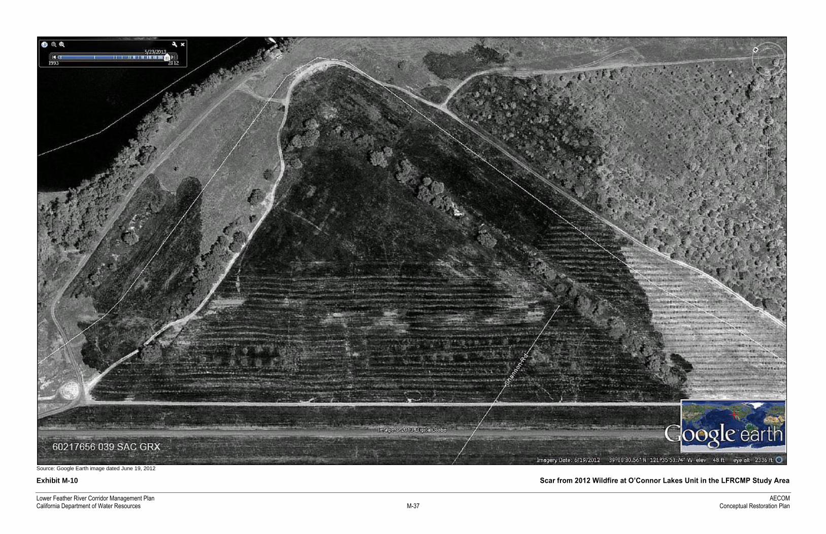
Exhibit M-10 shows where a wildfire occurred in 2012 at a restoration site in the O’Connor Lakes Unit of the
FRWA. The best fire prevention measures are reducing biomass fuel (dry thatch and annual grasses) in planted
areas and creating firebreaks by mowing or discing perimeters. Before flood season (which typically begins
November 15), all equipment, planting debris, and stockpiled material should also be removed.
IRRIGATION
Because of the dry summers typical of the climate in the area, irrigation would be required for the first 2–5 years
after installation to ensure plant establishment and survival. Soil characteristics at the restoration sites would
determine whether drip emitters, spray heads, and/or flood irrigation should be used. A plan view of a typical
container planting with drip emitter irrigation system is depicted in Exhibit M-8.
In the first growing season, the rapidly growing seedlings have roots only near the surface (the top 1–2 feet) of the
soil profile. During the first year, using soil moisture probes to monitor and maintain moisture throughout the soil
column is recommended to keep the shallow roots of young plants moist, ensuring optimum growth and survival.
The intervals between irrigations depend on soil texture, depth to water table, weather conditions, and plant water
stress. Because there would likely be a mixture of species with different water demands, the plants must be
observed carefully to maintain a balance of soil moisture that is acceptable for xeric species like valley oak and
elderberry as well as more mesic species like cottonwood and willow.
Lower Feather River Corridor Management Plan AECOM California Department of Water Resources M-33 Conceptual Restoration Plan
Source: AECOM 2011
Exhibit M-8 Typical Plan View of Woodland Planting Design and Cross Section of Container Planting with Irrigation Gutters

Lower Feather River Corridor Management Plan AECOM California Department of Water Resources M-35 Conceptual Restoration Plan
Source: AECOM 2011
Exhibit M-9 Cross Section of Plant Protection Cage and Tree Support Staking and Plan View of Container Planting with Irrigation

Lower Feather River Corridor Management Plan AECOM California Department of Water Resources M-37 Conceptual Restoration Plan
Source: Google Earth image dated June 19, 2012
Exhibit M-10 Scar from 2012 Wildfire at O’Connor Lakes Unit in the LFRCMP Study Area

Lower Feather River Corridor Management Plan AECOM California Department of Water Resources M-39 Conceptual Restoration Plan
The strategy for the second and third years is to “train” the roots to grow deep. Less frequent, deep watering will
encourage roots to grow deeper, well below the roots of the weeds, allowing the tree or shrub exclusive use of this
deep moisture. As the tree’s roots grow deeper, the times between irrigations become longer. This allows the soil
surface layers to dry, thereby further reducing weed vigor. Site conditions such as soil moisture storage and
permeability will determine the length of time that irrigation will be in place.
The irrigation system is typically composed of a connection to a water source (e.g., a modified agricultural well
head, or pumping from a nearby river or water body with portable pumps), a backflow preventor, sediment filters,
pumps, pipe, shut-off valves, drip emitters, and soaker tube. The project's planting irrigation specifications should
describe the connection to the water source.
M.5 REFERENCES
Bossard, C. C., J. M. Randall, and M. C. Hoshovsky (eds.). 2000. Invasive Plants of California Wildlands.
Berkeley: University of California Press.
California Department of Water Resources. 2011 (December). 2012 Central Valley Flood Protection Plan: A
Path for Improving Public Safety, Environmental Stewardship, and Long-Term Economic Stability.
Public Draft. Sacramento, CA.
———. 2012 (January). 2012 Central Valley Flood Protection Plan, Attachment 2: Conservation Framework.
Public Draft. Sacramento, CA.
Cal-IPC. See California Invasive Plant Council.
California Invasive Plant Council. 2011. The Impact of Invasive Plants. Available: http://www.cal-
ipc.org/ip/definitions/impact.php. Accessed March 15, 2011.
CalPIF and PRBO. See California Partners in Flight and PRBO Conservation Science.
California Partners in Flight and PRBO Conservation Science. 2002. The Oak Woodland Bird Conservation Plan:
A Strategy for Protecting and Managing Oak Woodland Habitats and Associated Birds in California.
Version 2.0. Petaluma, CA: PRBO Conservation Science. Available:
http://www.prbo.org/calpif/pdfs/oak.v-2.0.pdf. Accessed December 19, 2013.
Dettling, M. D., and C. A. Howell. 2011. Status of the Yellow-billed Cuckoo along the Sacramento River in 2010.
Report to California Department of Fish and Game. PRBO Contribution #1794. Petaluma, CA: PRBO
Conservation Science,
Dettling, M. D., and N. E. Seavy. 2013. Yellow‐billed Cuckoo Survey Effort along the Sacramento and Feather
Rivers 2012. Progress report to California Department of Fish and Game. PRBO Contribution #1915.
Petaluma, CA: PRBO Conservation Science.
Hagar, J. C. 1999. Influence of Riparian Buffer Width on Bird Assemblages in Western Oregon. Journal of
Wildlife Management 63:484–496.
AECOM Lower Feather River Corridor Management Plan Conceptual Restoration Plan M-40 California Department of Water Resources
Heath, S., and G. Ballard. 2003. Patterns of Breeding Songbird Diversity and Occurrence in Riparian Habitats of
the Eastern Sierra Nevada. In California Riparian Systems: Processes and Floodplain Management,
Ecology, and Restoration, Riparian Habitat and Floodplains Conference, ed. P. M. Faber. Sacramento,
CA: Riparian Habitat Joint Venture.
Howell, C. A., J. K. Wood, M. D. Dettling, K. Griggs, C. C. Otte, L. Lina, and T. Gardali. 2010. Least Bell’s
Vireo Breeding Records in the Central Valley Following Decades of Extirpation. Western North
American Naturalist 70(1):105–113.
Knopf, F. L., R. R. Johnson, R. Rich, F. B. Samson, and R. C. Szaro. 1988. Conservation of Riparian Ecosystems
in the United States. Wilson Bulletin 100:272–284.
Philip Williams and Associates. 2005. The Bear River Levee Setback Design: Assessments of Potential
Geomorphic Effects. Prepared for BE/GEI and Three Rivers Levee Improvement Authority.
Placer County Planning Department. 2005. Setback Recommendations to Conserve Riparian Areas and Streams
in Western Placer County. Prepared by Jones & Stokes, Sacramento, CA, in cooperation with Point Reyes
Bird Observatory, Petaluma, CA.
PWA. See Philip Williams and Associates.
RHJV. See Riparian Habitat Joint Venture.
Riparian Habitat Joint Venture. 2004. The Riparian Bird Conservation Plan: A Strategy for Reversing the Decline
of Riparian Associated Birds in California. Version 2.0. Stinson Beach, CA: PRBO Conservation
Science.
———. 2009 (July). California Riparian Habitat Restoration Handbook. Second Edition.
River Partners. 2005. Riparian Restoration Plan for Bear River Setback Levee Project. Yuba County, California.
Chico, CA.
———. 2006 (August 15). O’Connor Lakes Unit Riparian Restoration Plan, Feather River Wildlife Area, Sutter
County, CA. Chico, CA.
———. 2009a. Conceptual Land Management Plan for the Feather River Setback Levee Project. Chico, CA.
———. 2009b (March 6). Habitat Enhancement Plan for the Feather River Setback Levee and Habitat
Enhancement Project at Star Bend. Chico, CA.
Rosenberg, D., B. Noon, and E. Meslow. 1997. Biological Corridors: Form, Function, and Efficacy. Bioscience
47:677–687.
Three Rivers Levee Improvement Authority. 2013 (April 13). TRLIA Three Rivers Flood Corridor Project.
Application to the California Department of Water Resources’ Flood Protection Corridor Program.
TRLIA. See Three Rivers Levee Improvement Authority.

Lower Feather River Corridor Management Plan AECOM California Department of Water Resources M-41 Conceptual Restoration Plan
Wilson, R. A., P. Manley, and B. R. Noon. 1991. Covariance Patterns among Birds and Vegetating in a California
Oak Woodland. In Proceedings of the Symposium on Oak Woodlands and Hardwood Rangeland
Management, October 31–November 2, 1990, ed. R. B. Standiford, 126–135. General Technical Report
PSW-GTR-126. U.S. Forest Service, Pacific Southwest Research Station.

AECOM Lower Feather River Corridor Management Plan Conceptual Restoration Plan M-42 California Department of Water Resources
This page intentionally left blank.