Embed Size (px)
Citation preview

Los Coches Residential
- 1 –
Appendix G
ENVIRONMENTAL CHECKLIST FORM 1. Project title: Los Coches Residential 2. Lead agency name and address: City of Milpitas, 455 E Calaveras Blvd, Milpitas CA 95035 3. Contact person and phone number: Tiffany Brown, 408-586-3283 4. Project location: 31 S Milpitas Blvd (APN: 086-28-041, 086-39-003) 5. Project sponsor's name and address: Braddock and Logan, Andy Byde, 455 Blackhawk Plaza Circle, Danville, CA 94506 6. General plan designation: Town Center 7. Zoning: Town Center with Site and Architecture Overlay 8. Description of project: The project site consists of two separate parcels of land: one lot is a 7.4 acre built out parcel (APN: 086-28-041) containing a 95,950 square foot unoccupied R&D building with parking lot and the other lot identified as APN: 086-38-003 and approximately 3.9 acres, contains an unoccupied 51,074 square foot R&D building with associated parking. The project sites are located just south of Calaveras Blvd and to the west of S. Milpitas Blvd. The project application includes a Major Tentative Map (MT12-0003), Site Development Permit (SD12-0005), and a Conditional Use Permit (UP12-0020) requesting to allow for the demolition of the entire 11.3 acres and construction of 80 single-family residential homes including on and off-site pedestrian and bicycle oriented trial improvements. 9. Surrounding land uses and setting: Located to the west of the site is Wrigley Creek. To the North on the other side of the Calaveras Boulevard overpass is Terrace Garden Senior Living apartments and the Beresford Square shopping center, zoned Town Center. To the east is a built out center with two multi-tenant office buildings and two single tenant office buildings currently used for banking. The property to the south is zoned Heavy Industrial and is currently a business park. 10. Other agencies for review: Caltrans District #4, Fish & Game Region #3 and Toxic Substances Control Department
Los Coches Residential
- 2 –
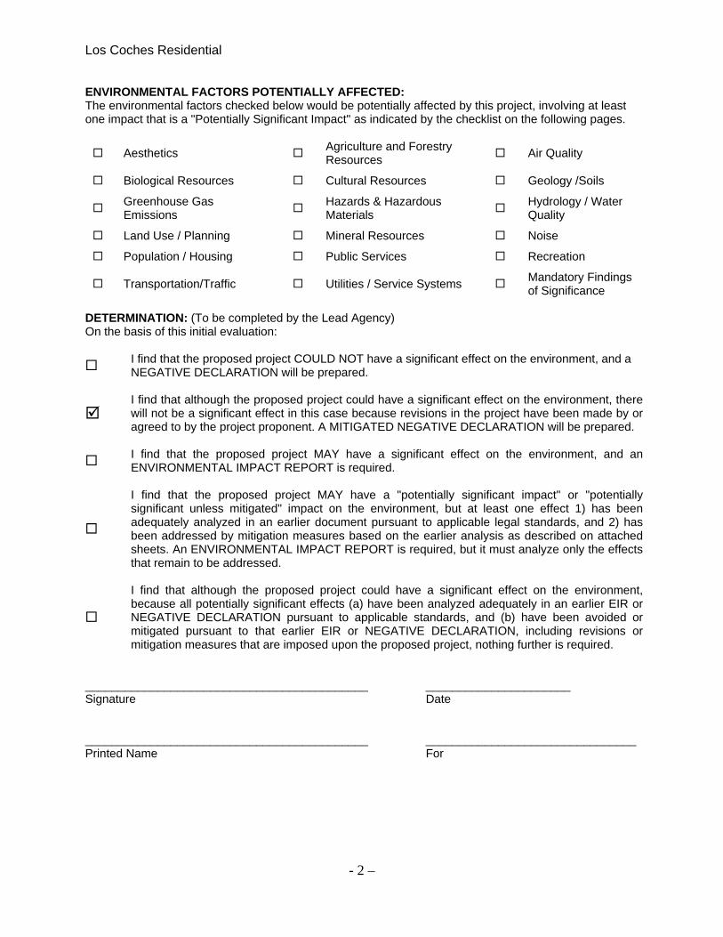
ENVIRONMENTAL FACTORS POTENTIALLY AFFECTED: The environmental factors checked below would be potentially affected by this project, involving at least one impact that is a "Potentially Significant Impact" as indicated by the checklist on the following pages.
Aesthetics Agriculture and Forestry Resources
Air Quality
Biological Resources Cultural Resources Geology /Soils
Greenhouse Gas Emissions
Hazards & Hazardous Materials
Hydrology / Water Quality
Land Use / Planning Mineral Resources Noise
Population / Housing Public Services Recreation
Transportation/Traffic Utilities / Service Systems Mandatory Findings of Significance
DETERMINATION: (To be completed by the Lead Agency) On the basis of this initial evaluation:
I find that the proposed project COULD NOT have a significant effect on the environment, and a NEGATIVE DECLARATION will be prepared.
I find that although the proposed project could have a significant effect on the environment, there
will not be a significant effect in this case because revisions in the project have been made by or agreed to by the project proponent. A MITIGATED NEGATIVE DECLARATION will be prepared.
I find that the proposed project MAY have a significant effect on the environment, and an ENVIRONMENTAL IMPACT REPORT is required.
I find that the proposed project MAY have a "potentially significant impact" or "potentially significant unless mitigated" impact on the environment, but at least one effect 1) has been adequately analyzed in an earlier document pursuant to applicable legal standards, and 2) has been addressed by mitigation measures based on the earlier analysis as described on attached sheets. An ENVIRONMENTAL IMPACT REPORT is required, but it must analyze only the effects that remain to be addressed.
I find that although the proposed project could have a significant effect on the environment, because all potentially significant effects (a) have been analyzed adequately in an earlier EIR or NEGATIVE DECLARATION pursuant to applicable standards, and (b) have been avoided or mitigated pursuant to that earlier EIR or NEGATIVE DECLARATION, including revisions or mitigation measures that are imposed upon the proposed project, nothing further is required.
___________________________________________ ______________________ Signature Date ___________________________________________ ________________________________ Printed Name For

Los Coches Residential
- 3 –
MAPS Figure 1: Regional Map
Project Location
Freemont
Milpitas
San Jose

Los Coches Residential
- 4 –
Figure 2: Vicinity Map

Los Coches Residential
- 5 –
EVALUATION OF ENVIRONMENTAL IMPACTS: 1. A brief explanation is required for all answers except "No Impact" answers that are adequately
supported by the information sources a lead agency cites in the parentheses following each question. A "No Impact" answer is adequately supported if the referenced information sources show that the impact simply does not apply to projects like the one involved (e.g., the project falls outside a fault rupture zone). A "No Impact" answer should be explained where it is based on project-specific factors as well as general standards (e.g., the project will not expose sensitive receptors to pollutants, based on a project-specific screening analysis).
2. All answers must take account of the whole action involved, including off-site as well as on-site,
cumulative as well as project-level, indirect as well as direct, and construction as well as operational impacts.
3. Once the lead agency has determined that a particular physical impact may occur, then the checklist
answers must indicate whether the impact is potentially significant, less than significant with mitigation, or less than significant. "Potentially Significant Impact" is appropriate if there is substantial evidence that an effect may be significant. If there are one or more "Potentially Significant Impact" entries when the determination is made, an EIR is required.
4. "Negative Declaration: Less Than Significant With Mitigation Incorporated" applies where the
incorporation of mitigation measures has reduced an effect from "Potentially Significant Impact" to a "Less Than Significant Impact." The lead agency must describe the mitigation measures, and briefly explain how they reduce the effect to a less than significant level (mitigation measures from "Earlier Analyses," as described in (5) below, may be cross-referenced).
5. Earlier analyses may be used where, pursuant to the tiering, program EIR, or other CEQA process,
an effect has been adequately analyzed in an earlier EIR or negative declaration. Section 15063(c)(3)(D). In this case, a brief discussion should identify the following:
a. Earlier Analysis Used. Identify and state where they are available for review. b. Impacts Adequately Addressed. Identify which effects from the above checklist were within the
scope of and adequately analyzed in an earlier document pursuant to applicable legal standards, and state whether such effects were addressed by mitigation measures based on the earlier analysis.
c. Mitigation Measures. For effects that are "Less than Significant with Mitigation Measures Incorporated," describe the mitigation measures which were incorporated or refined from the earlier document and the extent to which they address site-specific conditions for the project.
6. Lead agencies are encouraged to incorporate into the checklist references to information sources for
potential impacts (e.g., general plans, zoning ordinances). Reference to a previously prepared or outside document should, where appropriate, include a reference to the page or pages where the statement is substantiated.
7. Supporting Information Sources: A source list should be attached, and other sources used or
individuals contacted should be cited in the discussion. 8. This is only a suggested form, and lead agencies are free to use different formats; however, lead
agencies should normally address the questions from this checklist that are relevant to a project's environmental effects in whatever format is selected.
9. The explanation of each issue should identify:
a. the significance criteria or threshold, if any, used to evaluate each question; and b. the mitigation measure identified, if any, to reduce the impact to less than significance

Los Coches Residential
- 6 –
ISSUES
I. AESTHETICS
Potentially Significant
Impact
Less Than Significant
With Mitigation Incorporated
Less Than Significant
Impact No Impact
Information Source(s)
Would the project: 1) Have a substantial adverse effect
on a scenic vista? 2,4, 8
2) Substantially damage scenic resources, including, but not limited to, trees, rock outcroppings, and historic buildings within a state scenic highway?
2,4, 8
3) Substantially degrade the existing visual character or quality of the site and its surroundings?
2, 8
4) Create a new source of substantial light or glare which would adversely affect day or nighttime views in the area?
1, 8
Environmental Setting: The General Plan defines scenic resources as the foothills and the tree-lined Coyote Creek corridor. These resources provide a scenic backdrop and visual reference points for Milpitas. Scenic resources can be both natural and man-made. Figure 4-6 within the General Plan identifies hillsides, ridges visually significant vegetation and other elements that are deemed critical in shaping the City’s scenic identity. The project sites are set back behind the existing street facing commercial office buildings at South Milpitas Blvd., just south of the State Route 237 Calaveras Overpass. State Route 237, Calaveras is designated a Scenic Route and Connector. Scenic Routs, in this case, are streets that provide efficient connections between areas of scenic value or provide distant views of Scenic Resources. Scenic Connectors is the same as a Scenic Route, but a Scenic Connector may not necessarily traverse an area of scenic value, and the abutting land is not subject to the scenic Corridor land use controls. However, special design treatment – which may include roadside landscaping, undergrounding of utility lines, and street furnishings will be carried out to provide a visual continuity with the Scenic Corridors. The existing commercial office buildings located to the east of “in front” of the project site when facing the Scenic foothills, were built in the 1980’s and stand one to two stories high. Adjacent to the “back” or west of the project sites is Wriggly Creek and trail which abuts the Union Pacific Railroad Corporation yard and rail lines. The Union Pacific Railroad Corporation (UPRC) owns a large parking lot to the south of the project site. They are proposing new substantial amount of lighting for the parking lot that could affect the proposed project. See the attachment for future UPRC plans. This off-site source is an uncontrollable impact, and due to the type of lighting being proposed would be impossible to

Los Coches Residential
- 7 –
mitigate. However, the UPRC’s parking lot is far enough south of the project site that it is believed the lighting would only be a glare for the future residence. Comments/Conclusion: 1) Have a substantial adverse effect on a scenic vista? NI The proposed homes will be located next to the Scenic Route/Connector street known as State Route 237 Calaveras. When driving eastbound on Calaveras, the new residents will be visible from above on the Calaveras overpass. The proposal includes supplemental landscaping along the bank that abuts Calaveras Blvd and trail improvements along Wriggly Creek, which continue underneath the Calaveras Overpass to connect the community to the Beresford Shopping Center. The will enhance the streetscape for both the pedestrians and automotive users will maintaining a positive look for the scenic route/connector. 2) Substantially damage scenic resources, including, but not limited to, trees, rock outcroppings, and historic buildings within a state scenic highway? NI The proposed sites are unoccupied R&D buildings with associated parking lots. There will not be a disturbance of scenic resources such as trees, rock outcroppings or Historic Buildings. The property does not include any documented historical significance. 3) Substantially degrade the existing visual character or quality of the site and its surroundings? NI The sites are currently R&D buildings that have been vacant since November of 2002. The proposal will enhance the community by revitalizing the area with new single family homes, and enhance scenic routes/connectors by the addition of new landscaping along pedestrian connections and views on Calaveras Blvd. 4) Create a new source of substantial light or glare which would adversely affect day or nighttime views in the area? NI The proposed development project would demolish the existing buildings, grade and prepare the 11.3 acre site for 80 single family homes. The site lighting will change from parking lot and building security lighting to residential street lighting from residential home lighting. Proposed lighting includes bollard lighting for the trail and park, residential street lighting, and motion lights for the homes. Lighting for a residential use, although different from R&D lighting, will not create a new substantial amount of light or glare then the previous use and should not adversely affect day or nighttime views beyond the existing site lighting conditions.

Los Coches Residential
- 8 –
II. AGRICULTURAL AND FOREST RESOURCES In determining whether impacts to agricultural resources are significant environmental effects, lead agencies may refer to the California Agricultural Land Evaluation and Site Assessment Model (1997) prepared by the California Dept. of Conservation as an optional model to use in assessing impacts on agriculture and farmland. In determining whether impacts to forest resources, including timberland, are significant environmental effects, lead agencies may refer to information compiled by the California Department of Forestry and Fire Protection regarding the state’s inventory of forest land, including the Forest and Range Assessment Project and the Forest Legacy Assessment project; and forest carbon measurement methodology provided in Forest Protocols adopted by the California Air Resources Board.
Potentially Significant
Impact
Less Than Significant
With Mitigation Incorporated
Less Than Significant
Impact No Impact
Information Source(s)
Would the project:
1) Convert Prime Farmland, Unique Farmland, or Farmland of Statewide Importance (Farmland), as shown on the maps prepared pursuant to the Farmland Mapping and Monitoring Program of the California Resources Agency, to non-agricultural use?
1,2,4
2) Conflict with existing zoning for agricultural use, or a Williamson Act contract?
1,2
3) Conflict with existing zoning for, or cause rezoning of, forest land (as defined in Public Resources Code section 12220(g)) or timberland (as defined by Public Resources Code section 4526)?
4) Result in the loss of forest land or conversion of forest land to non-forest use?
5) Involve other changes in the existing environment which, due to their location or nature, could result in conversion of Farmland, to non-agricultural use or conversion of forest land to non-forest use?
1,2
Environmental Setting: The proposed project site is not currently used for agricultural purposes and is not designated as farmland. Conclusion: The proposed project would not result in impacts to agricultural resources. NI
Los Coches Residential
- 9 –
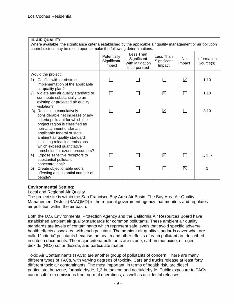
III. AIR QUALITY Where available, the significance criteria established by the applicable air quality management or air pollution control district may be relied upon to make the following determinations.
Potentially Significant
Impact
Less Than Significant
With Mitigation Incorporated
Less Than Significant
Impact
No Impact
Information Source(s)
Would the project:
1) Conflict with or obstruct implementation of the applicable air quality plan?
1,10
2) Violate any air quality standard or contribute substantially to an existing or projected air quality violation?
1,10
3) Result in a cumulatively considerable net increase of any criteria pollutant for which the project region is classified as non-attainment under an applicable federal or state ambient air quality standard including releasing emissions which exceed quantitative thresholds for ozone precursors?
3,10
4) Expose sensitive receptors to substantial pollutant concentrations?
1, 2, 7
5) Create objectionable odors affecting a substantial number of people?
1
Environmental Setting: Local and Regional Air Quality The project site is within the San Francisco Bay Area Air Basin. The Bay Area Air Quality Management District (BAAQMD) is the regional government agency that monitors and regulates air pollution within the air basin. Both the U.S. Environmental Protection Agency and the California Air Resources Board have established ambient air quality standards for common pollutants. These ambient air quality standards are levels of contaminants which represent safe levels that avoid specific adverse health effects associated with each pollutant. The ambient air quality standards cover what are called “criteria” pollutants because the health and other effects of each pollutant are described in criteria documents. The major criteria pollutants are ozone, carbon monoxide, nitrogen dioxide (NOx) sulfur dioxide, and particulate matter. Toxic Air Contaminants (TACs) are another group of pollutants of concern. There are many different types of TACs, with varying degrees of toxicity. Cars and trucks release at least forty different toxic air contaminants. The most important, in terms of health risk, are diesel particulate, benzene, formaldehyde, 1,3-butadiene and acetaldehyde. Public exposure to TACs can result from emissions from normal operations, as well as accidental releases.

Los Coches Residential
- 10 –
Sensitive Receptors BAAQMD defines sensitive receptors as facilities where sensitive receptor population groups (children, the elderly, the acutely ill and the chronically ill) are likely to be located. These land uses include residences, school playgrounds, childcare centers, retirement homes, convalescent homes, hospitals and medical clinics. There are no close receptors in close proximity to the project site. Comment: A GreenHouse Gas / Air Quality Technical Report for the project sites was conducted by Donald Ballanti, a Certified Consulting Meteorologist. Ambient Air Quality BAAQMD monitors air quality at several locations within the San Francisco bay Air Basin. The closest multi-pollutant monitoring site to the project sites is located in downtown San Jose on Jackson Street. The U.S. Environmental Protection Agency has classified the San Francisco Bay Area as a non-attainment area for the federal standard and PM2.5 standards. The Bay Area was designated as unclassifiable/attainment for the federal PM10 standard Under the California Clean Air Act, Santa Clara County is a non-attainment area for ozone and particulate matter. The county is either attainment or unclassified for other pollutants. Conclusion: 1) Conflict with or obstruct implementation of the applicable air quality plan? NI The San Francisco Bay Area Air Basin is currently non-attainment for ozone particulate matter. While an air quality plan exists for ozone, none currently exists for air quality plan. The project would not result in a substantial unplanned increase in population, employment, regional growth in vehicle miles traveled, or emissions so it could not conflict with or obstruct implementation of the air quality plan. 2) Violate any air quality standard or contribute substantially to an existing or projected air quality violation? LS Development projects in the Bay Area are most likely to violate an air quality standard or contribute substantially to an existing or projected air quality violation through generation of vehicle trips. New vehicle trips add to carbon monoxide concentrations near streets providing access to the site. Carbon Monoxide is an odorless, colorless poisonous gas whose primary source in the Bay Area is automobiles. Concentrations of this gas are highest near intersections of major roads. Based on existing surface road volumes in the project vicinity, the project would not increase traffic volumes at affected interactions to more then 44,000 vehicles per hour and would not affect any intersections where vertical and/or horizontal mixing is substantially limited. The report prepared by Donald Ballanti based this information on the California Environmental Health Tracking Program, and Traffic Volume Linkage Tools. Based on the BAAQMD criteria, the proposed project would have a less-then significant impact on carbon monoxide concentrations. 3) Result in a cumulatively considerable net increase of any criteria pollutant for which the project region is classified as non-attainment under an applicable federal or state ambient air quality standard including releasing emissions which exceed quantitative thresholds for ozone precursors? LS
Los Coches Residential
- 11 –
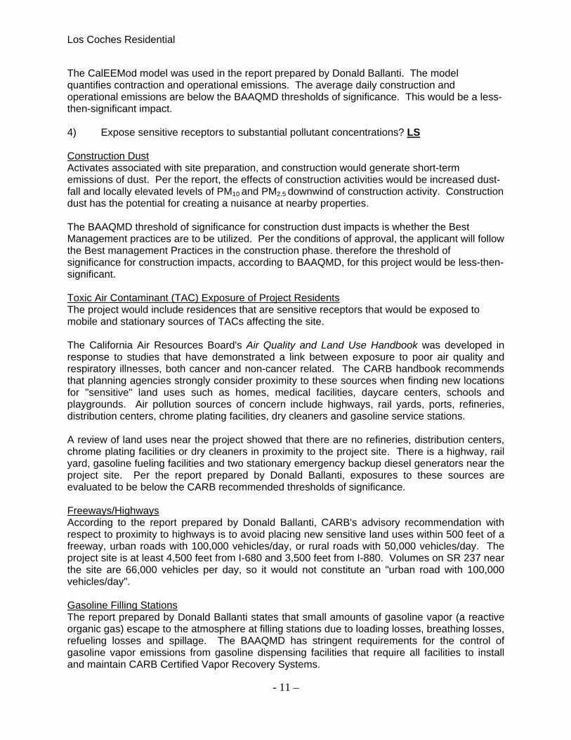
The CalEEMod model was used in the report prepared by Donald Ballanti. The model quantifies contraction and operational emissions. The average daily construction and operational emissions are below the BAAQMD thresholds of significance. This would be a less-then-significant impact. 4) Expose sensitive receptors to substantial pollutant concentrations? LS Construction Dust Activates associated with site preparation, and construction would generate short-term emissions of dust. Per the report, the effects of construction activities would be increased dust-fall and locally elevated levels of PM10 and PM2.5 downwind of construction activity. Construction dust has the potential for creating a nuisance at nearby properties. The BAAQMD threshold of significance for construction dust impacts is whether the Best Management practices are to be utilized. Per the conditions of approval, the applicant will follow the Best management Practices in the construction phase. therefore the threshold of significance for construction impacts, according to BAAQMD, for this project would be less-then-significant. Toxic Air Contaminant (TAC) Exposure of Project Residents The project would include residences that are sensitive receptors that would be exposed to mobile and stationary sources of TACs affecting the site. The California Air Resources Board's Air Quality and Land Use Handbook was developed in response to studies that have demonstrated a link between exposure to poor air quality and respiratory illnesses, both cancer and non-cancer related. The CARB handbook recommends that planning agencies strongly consider proximity to these sources when finding new locations for "sensitive" land uses such as homes, medical facilities, daycare centers, schools and playgrounds. Air pollution sources of concern include highways, rail yards, ports, refineries, distribution centers, chrome plating facilities, dry cleaners and gasoline service stations. A review of land uses near the project showed that there are no refineries, distribution centers, chrome plating facilities or dry cleaners in proximity to the project site. There is a highway, rail yard, gasoline fueling facilities and two stationary emergency backup diesel generators near the project site. Per the report prepared by Donald Ballanti, exposures to these sources are evaluated to be below the CARB recommended thresholds of significance. Freeways/Highways According to the report prepared by Donald Ballanti, CARB's advisory recommendation with respect to proximity to highways is to avoid placing new sensitive land uses within 500 feet of a freeway, urban roads with 100,000 vehicles/day, or rural roads with 50,000 vehicles/day. The project site is at least 4,500 feet from I-680 and 3,500 feet from I-880. Volumes on SR 237 near the site are 66,000 vehicles per day, so it would not constitute an "urban road with 100,000 vehicles/day". Gasoline Filling Stations The report prepared by Donald Ballanti states that small amounts of gasoline vapor (a reactive organic gas) escape to the atmosphere at filling stations due to loading losses, breathing losses, refueling losses and spillage. The BAAQMD has stringent requirements for the control of gasoline vapor emissions from gasoline dispensing facilities that require all facilities to install and maintain CARB Certified Vapor Recovery Systems.
Los Coches Residential
- 12 –
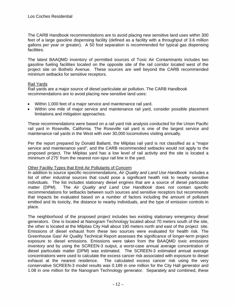
The CARB Handbook recommendations are to avoid placing new sensitive land uses within 300 feet of a large gasoline dispensing facility (defined as a facility with a throughput of 3.6 million gallons per year or greater). A 50 foot separation is recommended for typical gas dispensing facilities. The latest BAAQMD inventory of permitted sources of Toxic Air Contaminants includes two gasoline fueling facilities located on the opposite site of the rail corridor located west of the project site on Bothelo Avenue. These sources are well beyond the CARB recommended minimum setbacks for sensitive receptors. Rail Yards Rail yards are a major source of diesel particulate air pollution. The CARB Handbook recommendations are to avoid placing new sensitive land uses: Within 1,000 feet of a major service and maintenance rail yard. Within one mile of major service and maintenance rail yard, consider possible placement
limitations and mitigation approaches.
These recommendations were based on a rail yard risk analysis conducted for the Union Pacific rail yard in Roseville, California. The Roseville rail yard is one of the largest service and maintenance rail yards in the West with over 30,000 locomotives visiting annually. Per the report prepared by Donald Ballanti, the Milpitas rail yard is not classified as a "major service and maintenance yard", and the CARB recommended setbacks would not apply to the proposed project. The Milpitas yard has a low level of rail activity and the site is located a minimum of 275’ from the nearest non-spur rail line in the yard. Other Facility Types that Emit Air Pollutants of Concern In addition to source specific recommendations, Air Quality and Land Use Handbook includes a list of other industrial sources that could pose a significant health risk to nearby sensitive individuals. The list includes stationary diesel engines that are a source of diesel particulate matter (DPM). The Air Quality and Land Use Handbook does not contain specific recommendations for setbacks between such sources and sensitive receptors but recommends that impacts be evaluated based on a number of factors including the amount of pollutant emitted and its toxicity, the distance to nearby individuals, and the type of emission controls in place. The neighborhood of the proposed project includes two existing stationary emergency diesel generators. One is located at Nanogram Technology located about 70 meters south of the site, the other is located at the Milpitas City Hall about 190 meters north and east of the project site. Emissions of diesel exhaust from these two sources were evaluated for health risk. The Greenhouse Gas/ Air Quality Technical Report assesses the significance of longer-term project exposure to diesel emissions. Emissions were taken from the BAAQMD toxic emissions inventory and by using the SCREEN-3 output, a worst-case annual average concentration of diesel particulate matter (DPM) was estimated. The SCREEN-3 estimated annual average concentrations were used to calculate the excess cancer risk associated with exposure to diesel exhaust at the nearest residence. The calculated excess cancer risk using the very conservative SCREEN-3 model results was 0.189 in one million for the City Hall generator and 1.08 in one million for the Nanogram Technology generator. Separately and combined, these
Los Coches Residential
- 13 –
risk values are below the BAAQMD threshold of significance of 10 in one million contained in the 1999 CEQA Guidelines. Conclusion The project meets all CARB recommendations for minimum setbacks from freeways/highways, exposure to gasoline emissions and rail yard emissions. A health risk assessment found that exposure to emissions from permitted toxic air contaminant sources would be below the recommended threshold of significance. Project impacts due to exposure of sensitive receptors to toxic air contaminants would be a less-then-significant impact. 5) Create objectionable odors affecting a substantial number of people? NI The proposed project does not include uses that have been identified by BAAQMD as potential sources of objectionable odors. Sources of odors include restaurants, manufacturing plants, and agricultural operations and industrial operations such as wastewater treatment plants and solid waste transfer stations or landfills. As a new sensitive receptor for odors, the project is distant from the types of land uses that identified by the BAAQMD as having potential to create objectionable odors. Therefore the proposed project would have a no impact because it would not frequently create substantial objectionable odors affecting a substantial number of people.

Los Coches Residential
- 14 –
IV. BIOLOGICAL RESOURCES
Potentially Significant
Impact
Less Than Significant
With Mitigation Incorporated
Less Than Significant
Impact No Impact
Information Source(s)
Would the project:
1) Have a substantial adverse effect, either directly or through habitat modifications, on any species identified as a candidate, sensitive, or special status species in local or regional plans, policies, or regulations, or by the California Department of Fish and Game or U.S. Fish and Wildlife Service?
1,4
2) Have a substantial adverse effect on any riparian habitat or other sensitive natural community identified in local or regional plans, policies, regulations, or by the California Department of Fish and Game or U.S. Fish and Wildlife Service?
1,4
3) Have a substantial adverse effect on federally protected wetlands as defined by Section 404 of the Clean Water Act (including, but not limited to, marsh, vernal pool, coastal, etc.) through direct removal, filling, hydrological interruption, or other means?
1,4
4) Interfere substantially with the movement of any native resident or migratory fish or wildlife species or with established native resident or migratory wildlife corridors, impede the use of native wildlife nursery sites?
1,4
5) Conflict with any local policies or ordinances protecting biological resources, such as a tree preservation policy or ordinance?
1, 4, 8
6) Conflict with the provisions of an adopted Habitat Conservation Plan, Natural Community Conservation Plan, or other approved local, regional, or state habitat conservation plan?
1,4
Environmental Setting: The Planning Area and the surrounding region offer a variety of wildlife habitats, such as marshlands, riparian areas, grasslands, and woodlands. While much of the City is built-out,

Los Coches Residential
- 15 –
species supported by habitats such as Coyote Creek, salt marsh and mud flats to the west and the rolling hills of ED Levin Park and beyond to the east include the California coastal deer, gophers and water snakes, as well as rattlers, songbirds such as the mocking bird and the red-winged blackbird, upland game birds, pheasant, quails and doves, squirrels, and bobcats. Fish species found include bass, catfish, trout and other non-game species which may be found in the Calaveras Reservoir (east of the Planning Area), Sandy Wool Lake, periodically in Coyote Creek, and impounded waters within the foothills. Certain species are recognized as needing special protection under state and federal law due to their rare, endangered, or threatened status. These species are afforded varying degrees of protection through the applicable laws and regulations of the Federal Endangered Species Act, the California Native Plant Protection Act, the California Endangered Species Act, and the California Environmental Quality Act. The California Natural Diversity data Base (CNDDB), run by the California Department of Fish and game (CDFG), is the most complete single-source inventory of officially (state and federal) listed rare, endangered and threatened animals and plants, plus those considered by the scientific community to be deserving of such listing. An October 2010 search of the CNDDB for the Milpitas and Calaveras Reservoir Quadrangles identified 8 species with special status. It should be noted the Milpitas and Calaveras Reservoir Quadrangles contain areas that are outside of the Milpitas planning area. The CNDDB also inventories both terrestrial and aquatic natural communities that are of extremely high quality and/or very limited distribution; no such communities were found in Milpitas. The California Native Plant Society’s Inventory of Rare and Endangered Vascular Plants of California for the Milpitas and Calaveras Reservoir quads were also consulted. But again the reservoirs are outside the planning area. Comment: The properties are currently occupied by two vacant one-story office buildings that served as the former high-technology chip manufacturing facility with surrounding paved parking and landscaped areas. The property does not include protective Native Plants. Conclusion: As mentioned in the Environmental Setting, Per the California Natural Diversity Data Base, any identified rare, endangered and threatened animals and plants were found outside of the Milpitas Planning Area. Therefore the proposed project will have no-impact on Biological Resources.

Los Coches Residential
- 16 –
V. CULTURAL RESOURCES
Potentially Significant
Impact
Less Than Significant
With Mitigation Incorporated
Less Than Significant
Impact No Impact
Information Source(s)
Would the project: 1) Cause a substantial adverse
change in the significance of an historical resource as defined in §15064.5?
1,4
2) Cause a substantial adverse change in the significance of an archaeological resource as defined in §15064.5?
1,4
3) Directly or indirectly destroy a unique paleontological resource or site, or unique geologic feature?
1,4
4) Disturb any human remains, including those interred outside of formal cemeteries?
1,4
Environmental Setting: Prehistoric Period The lands now occupied by the City of Milpitas were once a part of the home territory of the Tamyen triblelet of Costanoan (ohlone) Indians. Like other Costanoan groups, the Tamyen maintained a few year-round village sites but also visited various temporary camps at different seasons of the year to hunt and gather food as it became available. The presence of a deposit of cinnabar (later famous as the mines of New Almaden) within Tamyen territory increased traffic through the early Milpitas area. The cinnabar (used as a body paint) stimulated considerable trade. The deposits were known over much of northern California, and parties from as far away as the Columbia River journeyed to Costanoan territory to obtain it. Trade for other items—such as wooden bows, salt, and pine nuts—also brought many visitors to the Tamyen territories Two notable Costanoan village sites lie within the city limits of Milpitas. One, a huge shellmound near the present-day Elmwood Rehabilitation Center, was discovered in 1949 and dates back to the eighteenth century. The other, on the site of the Alviso Adobe near the corner of Calaveras and Piedmont, is at least 3,000 years old and is one of only a handful of archaeological sites in California with such a long history of continuous occupation. Historic Period Aboriginal Milpitas must have been cris-crossed with a network of paths from village to village and from village to camp. For centuries, these aboriginal footpaths and deer trails were the only roadways of Milpitas. The year 1769 marked the most dramatic event since human beings first migrated into the Bay Area; in that year, the expedition of Gaspar de Portola inaugurated the historic era, bringing in its wake a host of changes. The expedition passed through Milpitas.

Los Coches Residential
- 17 –
The Spanish presence in the South Bay region was rapidly modified over the next few decades. Over the following half-century, the mission holdings were broken up by secularization, supplanted by private land grants such as the Rancho de Milpitas. Milpitas was already achieving distinction as a stopover point by the late 1840’s when Higuera Adobe welcomed travelers on the immigrant trail between Sutter’s Fort and San Jose, via Livermore Pass. In 1855, settlers in the Calaveras Valley petitioned for a county road across the flats to Alviso. The resulting intersection – where the Alviso road crossed the Mission Road, encouraged the development of Milpitas. By the late 1850’s a stage line was operating between San Jose and Oakland, with stops at Milpitas, as general stores, stables, saloons, hotels, blacksmiths, carriage shops, and a post office catered to the needs of farming families. Comment: Cultural resources and historic districts are designated by the City Council on the preconformation of the Parks, Recreation and Cultural Resources Commission. Currently there are fifteen sites officially designated and locally registered as a Milpitas Cultural Resources. Of the fifteen sites, the Alviso Adobe and Milpitas Grammar School are included in the National Register of Historic Places. The proposed project sites are not listed as a Historical and/or Cultural Resource. The primary impact that could occur would be disturbance of cultural resources during grading and/or development of property. Existing national, state and local laws as well as policies contained in the General Plan would reduce these potential impacts on historic and archaeological resources to less than significant levels. Conclusion: Buried Prehistoric and Historic Resources The proposed project does include disturbance of soils for trenching, site grading and other construction activities. Although it is unlikely that buried cultural materials would be encountered, standard conditions for excavation activities would be applied to the project as described below. Mitigation Measure 1: The proposed project shall implement the following standard measure: CUL-1: As required by County ordinance, this project has incorporated the following guidelines. - Pursuant to Section 7050.5 of the Health and Safety Code, and Section 5097.94 of the Public Resources Code of the State of California in the event of the discovery of human remains during construction, there shall be no further excavation or disturbance of the site or any nearby area reasonably suspected to overlie adjacent remains. The Santa Clara County Coroner shall be notified and shall make a determination as to whether the remains are Native American. If the Coroner determines that the remains are not subject to his authority, he shall notify the Native American Heritage Commission who shall attempt to identify descendants of the deceased Native American. If no satisfactory agreement can be reached as to the disposition of the remains pursuant to this State law, then the land owner shall re-bury the human remains and items associated with Native American burials on the property in a location not subject to further subsurface disturbance. Conclusion: The proposed project, with the implementation of the above mitigation measure, would not result in significant impacts to cultural resources. LS/M
Los Coches Residential
- 18 –
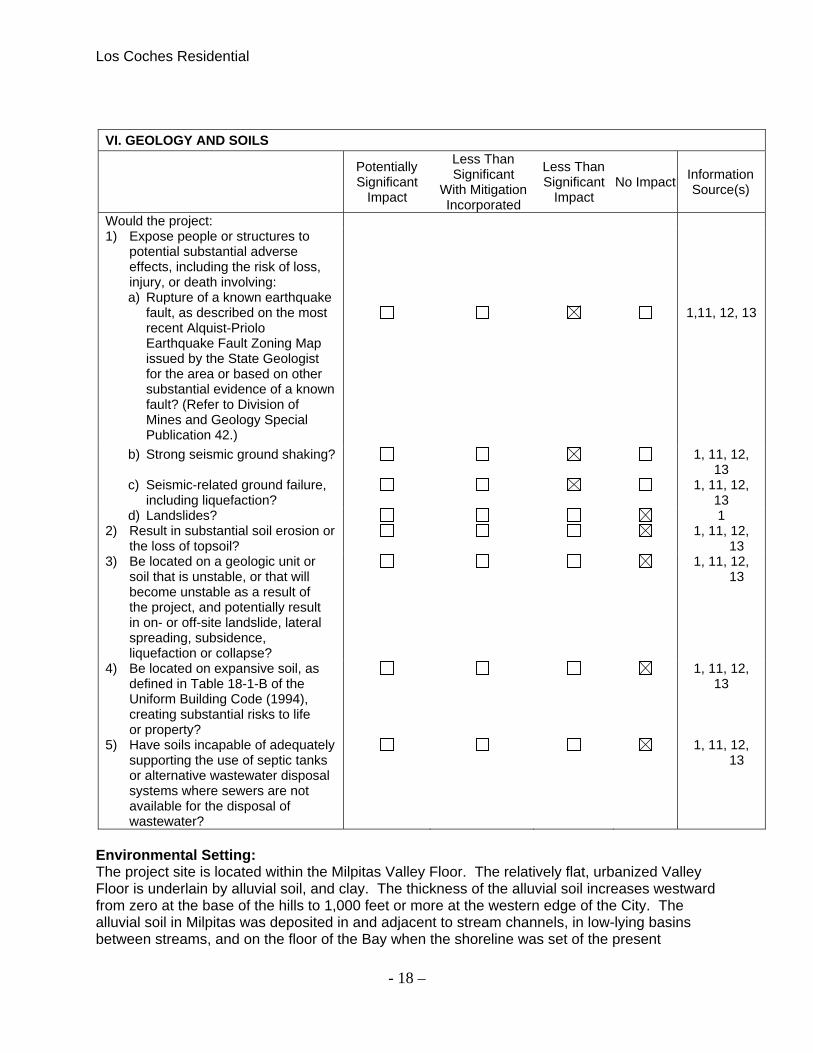
VI. GEOLOGY AND SOILS
Potentially Significant
Impact
Less Than Significant
With Mitigation Incorporated
Less Than Significant
Impact No Impact
Information Source(s)
Would the project: 1) Expose people or structures to
potential substantial adverse effects, including the risk of loss, injury, or death involving: a) Rupture of a known earthquake
fault, as described on the most recent Alquist-Priolo Earthquake Fault Zoning Map issued by the State Geologist for the area or based on other substantial evidence of a known fault? (Refer to Division of Mines and Geology Special Publication 42.)
1,11, 12, 13
b) Strong seismic ground shaking? 1, 11, 12, 13
c) Seismic-related ground failure, including liquefaction?
1, 11, 12, 13
d) Landslides? 1 2) Result in substantial soil erosion or
the loss of topsoil? 1, 11, 12,
13 3) Be located on a geologic unit or
soil that is unstable, or that will become unstable as a result of the project, and potentially result in on- or off-site landslide, lateral spreading, subsidence, liquefaction or collapse?
1, 11, 12, 13
4) Be located on expansive soil, as defined in Table 18-1-B of the Uniform Building Code (1994), creating substantial risks to life or property?
1, 11, 12, 13
5) Have soils incapable of adequately supporting the use of septic tanks or alternative wastewater disposal systems where sewers are not available for the disposal of wastewater?
1, 11, 12, 13
Environmental Setting: The project site is located within the Milpitas Valley Floor. The relatively flat, urbanized Valley Floor is underlain by alluvial soil, and clay. The thickness of the alluvial soil increases westward from zero at the base of the hills to 1,000 feet or more at the western edge of the City. The alluvial soil in Milpitas was deposited in and adjacent to stream channels, in low-lying basins between streams, and on the floor of the Bay when the shoreline was set of the present

Los Coches Residential
- 19 –
position. The composition and consistency of alluvial soils varies laterally and vertically over small distances and depths. Most of the alluvial soil in Milpitas is expansive and susceptible to liquefaction, and alluvial areas along creeks may be susceptible to lateral spreading. Local areas have compressible soils, poorly drained soils, shallow ground water, or are susceptible to lateral spreading. Because soil composition varies vertically as well as laterally, several soil types may underlie a particular site. Comment: Per the General Plan Seismic and Geological Hazards Section under Geology and Soils, the project sites are located in the Valley Floor zone outside of mapped compressible soils, expansive soils, liquefiable soils, or unstable soils on slopes. Per the Seismic and Geotechnical evaluations within the General Plan, the project sites are located within a Liquefaction-Prone zone, but not located within a fault rupture zone or landslide hazard zone. Although the project area is located outside of the Alquist-Priolo Fault zone, the site is in a seismically active region. Geologic conditions on the site will require that the new buildings be designed and constructed in accordance with standard engineering techniques and Uniform Building Code guidelines for Seismic Zones to avoid or minimize potential damage from seismic shaking and liquefaction on the site. Any proposed development will be designed and constructed in accordance with a design level geotechnical investigation prepared for the site, which will identify the specific design features that will be required for the project, including site preparation, re-compaction and lime treatment of subgrade solid, fill replacement and compaction, trench excavations, surface drainage, flexible pavements, slabs-on-grade and curbs, landscape retaining walls, and foundations. With implementation of recommendations in the design level geotechnical report, the project will not expose people or property to significant impacts associated with geologic or seismic conditions on site. Conclusion: The proposed project would not result in significant, adverse geology, soils, or seismicity impacts that cannot be avoided through standard engineering and construction techniques. LS

Los Coches Residential
- 20 –
VII. GREENHOUSE GAS EMISSIONS
Potentially Significant
Impact
Less Than Significant
With Mitigation Incorporated
Less Than Significant
Impact No Impact
Information Source(s)
Would the project: 1) Generate greenhouse gas
emissions, either directly or indirectly, that may have a significant impact on the environment?
2, 3
2) Conflict with any applicable plan, policy or regulation of an agency adopted for the purpose of reducing the emissions of greenhouse gases?
2, 3
Environmental Comment: A GreenHouse Gas / Air Quality Technical Report for the project sites was conducted by Donald Ballanti, a Certified Consulting Meteorologist. Per the report, gases that trap heat in the atmosphere are referred to as greenhouse gasses because they capture heat radiated from the sun as it is reflected back into the atmosphere, much like a greenhouse does. The accumulation of greenhouse gasses has been implicated as a driving force for global climate change. Definitions of climate change vary, but in general can be described as the changing of the earth’s climate caused by natural fluctuations and anthropogenic activities which alter the composition of the global atmosphere. The most common greenhouse gas that results from human activity is carbon dioxide, followed by methane and nitrous oxide. The last three of the six identified greenhouse gasses are primarily emitted by industrial facilities. The study was based on the primary greenhouse gasses which are: Carbon Dioxide, primarily generated by fossil fuel, Methane, emitted from biogenic sources landfills, and leaks in natural gas pipelines, and Nitrous Oxide, produced by both natural and human-related sources like agricultural uses. Conclusion: The CalEEmod program estimated construction and operational emissions of greenhouse gases for the proposed project. Project construction emissions were calculated as 1761.08 MTCO2E, to be emitted over the construction period. Construction emissions are generally considered separately from operational emissions because construction emissions are a one-time event, while operational emissions would be continuous over the life of the project. BAAQMD has no adopted thresholds for construction emissions but recommends quantification and disclosure of these emissions. The BAAQMD significance threshold for operational GHG emissions is that a development project, other than a stationary source, would have significant cumulative impact unless: The project can be shown to be in compliance with a qualified Climate Action Plan; or Project emissions of CO2 equivalent GHGs (CO2e) are less than 1,100 metric tons per year;
or Project emissions of CO2 equivalent GHGs are less than 4.6 metric tons per year per service
population (residents plus employees).

Los Coches Residential
- 21 –
Project GHG emissions are below the 1100 metric tons per year, so project GHG impacts would be less-than-significant.
Los Coches Residential
- 22 –
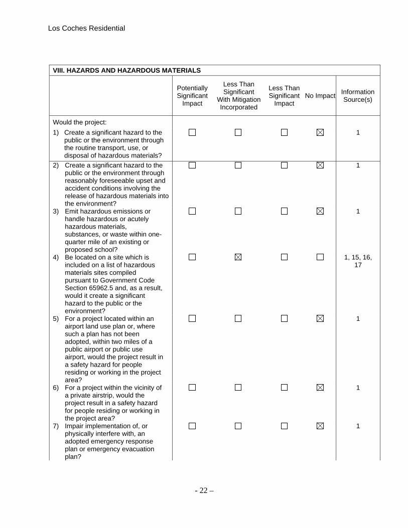
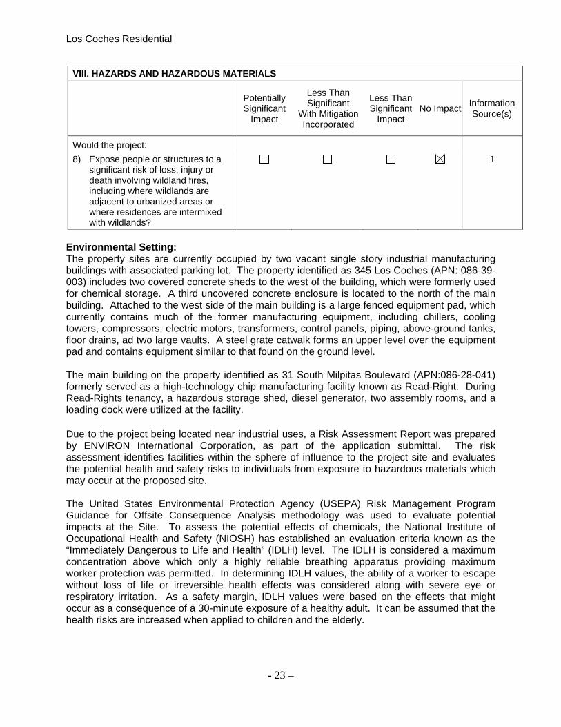
VIII. HAZARDS AND HAZARDOUS MATERIALS
Potentially Significant
Impact
Less Than Significant
With Mitigation Incorporated
Less Than Significant
Impact No Impact
Information Source(s)
Would the project:
1) Create a significant hazard to the public or the environment through the routine transport, use, or disposal of hazardous materials?
1
2) Create a significant hazard to the public or the environment through reasonably foreseeable upset and accident conditions involving the release of hazardous materials into the environment?
1
3) Emit hazardous emissions or handle hazardous or acutely hazardous materials, substances, or waste within one-quarter mile of an existing or proposed school?
1
4) Be located on a site which is included on a list of hazardous materials sites compiled pursuant to Government Code Section 65962.5 and, as a result, would it create a significant hazard to the public or the environment?
1, 15, 16, 17
5) For a project located within an airport land use plan or, where such a plan has not been adopted, within two miles of a public airport or public use airport, would the project result in a safety hazard for people residing or working in the project area?
1
6) For a project within the vicinity of a private airstrip, would the project result in a safety hazard for people residing or working in the project area?
1
7) Impair implementation of, or physically interfere with, an adopted emergency response plan or emergency evacuation plan?
1
Los Coches Residential
- 23 –
VIII. HAZARDS AND HAZARDOUS MATERIALS
Potentially Significant
Impact
Less Than Significant
With Mitigation Incorporated
Less Than Significant
Impact No Impact
Information Source(s)
Would the project:
8) Expose people or structures to a significant risk of loss, injury or death involving wildland fires, including where wildlands are adjacent to urbanized areas or where residences are intermixed with wildlands?
1
Environmental Setting: The property sites are currently occupied by two vacant single story industrial manufacturing buildings with associated parking lot. The property identified as 345 Los Coches (APN: 086-39-003) includes two covered concrete sheds to the west of the building, which were formerly used for chemical storage. A third uncovered concrete enclosure is located to the north of the main building. Attached to the west side of the main building is a large fenced equipment pad, which currently contains much of the former manufacturing equipment, including chillers, cooling towers, compressors, electric motors, transformers, control panels, piping, above-ground tanks, floor drains, ad two large vaults. A steel grate catwalk forms an upper level over the equipment pad and contains equipment similar to that found on the ground level. The main building on the property identified as 31 South Milpitas Boulevard (APN:086-28-041) formerly served as a high-technology chip manufacturing facility known as Read-Right. During Read-Rights tenancy, a hazardous storage shed, diesel generator, two assembly rooms, and a loading dock were utilized at the facility. Due to the project being located near industrial uses, a Risk Assessment Report was prepared by ENVIRON International Corporation, as part of the application submittal. The risk assessment identifies facilities within the sphere of influence to the project site and evaluates the potential health and safety risks to individuals from exposure to hazardous materials which may occur at the proposed site. The United States Environmental Protection Agency (USEPA) Risk Management Program Guidance for Offsite Consequence Analysis methodology was used to evaluate potential impacts at the Site. To assess the potential effects of chemicals, the National Institute of Occupational Health and Safety (NIOSH) has established an evaluation criteria known as the “Immediately Dangerous to Life and Health” (IDLH) level. The IDLH is considered a maximum concentration above which only a highly reliable breathing apparatus providing maximum worker protection was permitted. In determining IDLH values, the ability of a worker to escape without loss of life or irreversible health effects was considered along with severe eye or respiratory irritation. As a safety margin, IDLH values were based on the effects that might occur as a consequence of a 30-minute exposure of a healthy adult. It can be assumed that the health risks are increased when applied to children and the elderly.

Los Coches Residential
- 24 –
Comment: A Phase I and Phase II were conducted for both sites. Based on the finding s of the Phase I and Phase II Environmental Site Assessments, ENGEO did not identify any significant environmental impacts associated with the property known as 31 S Milpitas Boulevard. Therefore, based on the reports, no constraints for future residential development were identified. The Phase I and Phase II Environmental Site Assessments for the property identified as 345 Los Coches noted soil gas and sub-slab soil gas detections and recommended that an additional subsurface investigation be done to characterize the extent of previously identified impacts. In April 2012 ENGEO preformed additional sub-slab soil gas samplings and ground water samplings. A Vapor Intrusion Risk Assessment report dated June 28, 212, was prepared by SLR Corporation and ENGEO. The risk assessment was prepared to confirm the detected soil gas compounds do not pose a risk for future residential development. The results of the environmental assessment have identified minimal impacts to soil, soil vapor and groundwater. VOCs and SVOCs are also present in vadose zone soil at concentrations exceeding screening levels for groundwater protection; however, since groundwater impacts are minimal, and groundwater will not be utilized for the proposed future development, ENGEO determined that no significant constraints for future residential development exits on the site. However, if construction dewatering is anticipated in association with future site development, a groundwater management program will be required. The Vapor Intrusion Risk Assessment prepared for the property found no exceedance of the cumulative lifetime excess cancer risk (LECR) or non-cancer hazard index (HI). Therefore, adverse effects to human health under the proposed future land use are not anticipated at the reported concentrations. The Risk Assessment identifies four facilities within a quarter mile of the project site that store and use toxic gases and that upon an accidental release could impact the project site. The four facilities are: Headway Technologies, 497 S Hillview Drive, Linear Technology Corporation, 275 South Hillview Drive, Nanogram Corporation, 165 Topaz Street, and Magic technologies, 463 South Milpitas Boulevard.
Facilities with Toxic Gas Linear Technology 275 S. Hillview Drive
Magic Technologies 463 S Milpitas
Nanogram 165 Topaz
Headway Technologies 497 S Hillview Drive
Chemical Gas Used by Businesses Ammonia, anhydrous Ammonia Ammonia,
anhydrous Ammonia, anhydrous
Boron Trifluoride Boron Trichloride Diborane Born Trichloride
Chlorine Carbon Monoxide Phosphine Chlorine
Diborane Chlorine-250 Sulfur Hexafluoride Sodium Hydroxide
Hydrogen Bromide Hydrogen Bromide Sulfuric Acid
Hydrogen Chloride
Phosphine

Los Coches Residential
- 25 –
Tungsten Hexafluoride
Arsine
Dichlorosilane
Nitrogen Trifluoride
Sodium Hydroxide
Sulfuric Acid
Sulfur Hexafluoride
Tungsten Hexafluoride The Project is in the 1/10 IDLH concentration zone of impacts for the above listed four facilities. The Project is also in the TEP concentration zone of impact for the same four industrial businesses. System Services of America, Inc., located at 1029 Montague Expressway uses anhydrous ammonia. The distance to the IDLJ, TEP and 1/10 IDLH concentrations are 0.4, and 1.1 miles from System Services of America. The project sites are located 1.2 miles to the noth-northwest of the business, and as such is outside the IDLK, TEP and 1/10 IDLH zones of impact for anhydrous ammonia. Under the worst-case scenario for the actual amount of anhydrous ammonia stored in the single largest vessel, the project is not located within the hypothetical distance to the 1/10 IDLH concentrations of anhydrous ammonia. Conclusion: Based on the Phase I, PhaseII, Sub-Slab Vapor and Groundwater Assessment, and Vapor Intrusion risk Assessment, conducted by ENGEO, the conclusion that potential indoor inhalation risks to future residents do not exceed levels of regulatory concern based on the reported chemical concentration and that prior to construction, a groundwater management program will be required, the impacts of the new residential project are less then significant with mitigations. Mitigation Measure: The proposed project shall implement the following standard measure: HAZMAT-1.1: If construction dewatering is anticipated in association with future site development, a groundwater management program will be required. Based on the Risk Assessment provided by ENVIRON dated November 8, 2012, only one of the industrial facilities uses chemicals in amounts larger than the CalARP Threshold Quantity. Facilities using regulated substances in a process in excess of the CalARP Threshold Quantity are subject to CalARP Program requirements, which vary depending on the location, size, and type of the facility. System services of America, Inc., is assumed to be compliant with CalARP requirements. The subject property, however is located far enough away from System Services of America, INC. to not be within its CALARP TEP zone of impact for anhydrous ammonia. Although the project is not within the CalARP TEP zone of impact, as a result of being within the 1/10 IDLJ zones of impact of anhydrous ammonia, chlorine, diborane, hydrogen bromide, and phosphine, ENVIRON is recommending the following mitigation measures.

Los Coches Residential
- 26 –
Mitigation Measure: The proposed project shall implement the following standard measures: HAZMAT-1.2: The Project will provide an Emergency Action Plan (EAP) with evacuation and shelter-in-place procedures to the Milpitas Fire Department. HAZMAT-1.3: The project howmowners association should review this RAP and the EAP, update the RAP and EAP as required and submit the RAP and EAP to the Milpitas Fire Department on an annual basis.
IX. HYDROLOGY AND WATER QUALITY
Potentially Significant
Impact
Less Than Significant
With Mitigation Incorporated
Less Than Significant
Impact No Impact
Information Source(s)
Would the project:
1) Violate any water quality standards or waste discharge requirements?
1,2
2) Substantially deplete groundwater supplies or interfere substantially with groundwater recharge such that there would be a net deficit in aquifer volume or a lowering of the local groundwater table level (e.g., the production rate of pre-existing nearby wells would drop to a level which would not support existing land uses or planned uses for which permits have been granted)?
1,2
3) Substantially alter the existing drainage pattern of the site or area, including through the alteration of the course of a stream or river, in a manner which would result in substantial erosion or siltation on-or off-site?
1,2
4) Substantially alter the existing drainage pattern of the site or area, including through the alteration of the course of a stream or river, or substantially increase the rate or amount of surface runoff in a manner which would result in flooding on-or off-site?
1,2
5) Create or contribute runoff water which would exceed the capacity of existing or planned storm water drainage systems or provide substantial additional sources of polluted runoff?
1,2
6) Otherwise substantially degrade water quality?
1,2

Los Coches Residential
- 27 –
IX. HYDROLOGY AND WATER QUALITY
Potentially Significant
Impact
Less Than Significant
With Mitigation Incorporated
Less Than Significant
Impact No Impact
Information Source(s)
Would the project:
7) Place housing within a 100-year flood hazard area as mapped on a Federal Flood Hazard Boundary or Flood Insurance Rate Map or other flood hazard delineation map?
1,2, 14
8) Place within a 100-year flood hazard area structures which would impede or redirect flood flows?
1, 2, 14
9) Expose people or structures to a significant risk of loss, injury, or death involving flooding, including flooding as a result of the failure of a levee or dam?
1,2
10) Be subject to inundation by seiche, tsunami, or mudflow?
1,2
Environmental Setting: Comment: Drainage and Flooding All new development would conform to the City flood hazard management ordinance and therefore, the implementation of the project would not result in people or structures being exposed to any significant flood risk. Impervious surfaces on the proposed project would be approximately the same as the amount of impervious surfaces that exist on the site. New landscaping and/or vegetated bioswales would be installed on site as part of the project, and designed to detain stormwater runoff and infiltrate excess water into the soil. This would ensure that stormwater runoff from the project site would not exceed the capacity of the existing storm drainage system, or contribute significantly to downstream flooding. Water Quality The proposed development project includes stormwater quality best management practices such as directing site runoff into vegetated swales in conformance with requirements in the City of Milpitas’s Municipal NPDES Permit. The coverage of impervious surfaces would be no more than the current condition. Vegetated swales may be located in or adjacent to trees and shrubs, but must include only vegetation consistent with their function. Construction activities on the development site would temporarily generate dust, sediment, litter, oil, paint, and other pollutants that could contaminate runoff from the site. [Significant Impact] Mitigation Measures: The following mitigation measures are included in the project to reduce water quality impacts during construction and post-construction periods to a less than significant level:
Los Coches Residential
- 28 –
HYDRO-1.1: Prior to construction of the project, the City shall require the applicant to submit a Storm Water Pollution Prevention Plan (SWPPP) and a Notice of Intent (NOI) to the State of California Water Resource Quality Control Board to control the discharge of storm water pollutants including sediments associated with construction activities. Along with these documents, the applicant may also be required to prepare an Erosion Control Plan. The Erosion Control Plan may include Best Management Practices (BMPs) as specified in the California Storm Water Best Management Practice Handbook (such as silt fences/straw waddles around the perimeter of the site, regular street cleaning, and inlet protection) for reducing impacts on the City’s storm drainage system from construction activities. The SWPPP shall include control measures during the construction period for:
Soil stabilization practices, Sediment control practices, Sediment tracking control practices, Wind erosion control practices, and Non-storm water management and waste management and disposal control
practices. HYDRO-1.2: Prior to issuance of a grading permit, the applicant shall be required to submit copies of the NOI and Erosion Control Plan (if required) to the Department of Public Works. The applicant shall also be required to maintain a copy of the most current SWPPP on-site and provide a copy to any City representative or inspector on demand. HYDRO-1.3: The development shall comply with City of Milpitas ordinances, including erosion- and dust-control during site preparation and grading, and maintaining adjacent streets free of dirt and mud during construction. HYDRO-1.4: The proposed development shall comply with the NPDES permit issued to the City of Milpitas. Conclusion: The proposed project would not result in substantial adverse flooding or drainage impacts, and with implementation of the mitigation measures included in the project, possible impacts to water quality would be reduced to a less than significant level. LS/M
Los Coches Residential
- 29 –
X. LAND USE
Potentially Significant
Impact
Less Than Significant
With Mitigation Incorporated
Less Than Significant
Impact No Impact
Information Source(s)
Would the project:
1) Physically divide an established community?
1, 2
2) Conflict with any applicable land use plan, policy, or regulation of an agency with jurisdiction over the project (including, but not limited to the general plan, specific plan, local coastal program, or zoning ordinance) adopted for the purpose of avoiding or mitigating an environmental effect?
1, 2
3) Conflict with any applicable habitat conservation plan or natural community conservation plan?
1, 2, 4
Environmental Setting: The project sites are zoned Town Center. Town Center allows for both commercial and residential uses. The properties are bound by the East Calavrta Boulevard to the north, Wells Fargo Bank Union Bank to the east, two unoccupied commercial/industrial strues to the south, and Western Pacific Railorad tracks near Wriggly Creek to the west. The proposed project includes the construction of 80 new single family residential homes located on the northwest corner of the intersection of South Milpitas Blvd and Los Coches Street. All access to the site will be from a main entrance onto Los Coches Street with secondary access onto Topaz Street (which is an extension of Los Coches Street.) The project includes off-site improvements to the Wriggly Creek Trail that will provide a pedestrian/bike connection between the project site and the future residence to the existing Terra Serena Senior housing and Beresford Commercial Shopping Center located just north of Calaveras Blvd. The project will also provide new access to the Wriggly Creek Trail from S Milpitas Blvd Street. Conclusion: The project proposal will establish a new residential neighborhood that includes both pedestrian and vehicle connections to nearby commercial areas. The proposed residential land use and density is conditionally permitted within the Town Center Zoning district, and is consistent with General Plan. The properties are currently occupied by two vacant one-story R&D buildings that served as former manufacturing facilities and associated parking lot. Because the project sites are currently built out, there is no conflict with any applicable habitats. Nor does the proposed plan conflict with a conservation plan, or natural community conservation plan. The proposed project will have no impact. NI

Los Coches Residential
- 30 –
XI. MINERAL RESOURCES
Potentially Significant
Impact
Less Than Significant
With Mitigation Incorporated
Less Than Significant
Impact No Impact
Information Source(s)
Would the project: 1) Result in the loss of availability of a
known mineral resource that would be of value to the region and the residents of the state?
1, 4
2) Result in the loss of availability of a locally-important mineral resource recovery site delineated on a local general plan, specific plan or other land use plan?
1, 4
Environmental Setting: Per the General Plan Section 4.5 for Mineral Resources, there are four areas identified by the State Geologist as containing Regionally Significant Construction Aggregate Resources. These areas are located in the foothills outside the City Limits. Comment: The project site is located on the valley floor of Milpitas, far from the four identified sites, therefore the proposed project will have no impact on mineral resources.
Los Coches Residential
- 31 –
XII. NOISE
Potentially Significant
Impact
Less Than Significant
With Mitigation Incorporated
Less Than Significant
Impact No Impact
Information Source(s)
Would the project result in:
1) Exposure of persons to or generation of noise levels in excess of standards established in the local general plan or noise ordinance, or applicable standards of other agencies?
1, 6
2) Exposure of persons to, or generation of, excessive groundborne vibration or groundborne noise levels?
1, 6
3) A substantial permanent increase in ambient noise levels in the project vicinity above levels existing without the project?
1, 6
4) A substantial temporary or periodic increase in ambient noise levels in the project vicinity above levels existing without the project?
1, 6
5) For a project located within an airport land use plan or, where such a plan has not been adopted, within two miles of a public airport or public use airport, would the project expose people residing or working in the project area to excessive noise levels?
1, 6
6) For a project within the vicinity of a private airstrip, would the project expose people residing or working in the project area to excessive noise levels?
1, 6
Environmental Setting: The of City of Milpitas General Plan Noise Element sets forth implementing policies to guide the development of residential and commercial land uses. For single-family residential land use, up to 60 dBA Ldn is considered normally acceptable, up to 70 dBA Ldn is considered conditionally acceptable, and above 70 dBA Ldn is considered normally unacceptable. The project site is located southwest of the intersection of Calaveras Boulevard and Milpitas Boulevard. There is a rail yard west of the project site, a light industrial/manufacturing facility south of the site, office/commercial uses east of the site and Calaveras Boulevard is elevated above the site to the north. All of these transportation and industrial facilities contribute to the existing noise environment. Under future conditions, the new BART extension, per the planned Silicon Valley BART extension, rail will be located along the west side of the project near the existing rail track

Los Coches Residential
- 32 –
nearest to the project site, the centerline of which would be located between 150 to 250 feet from the western property line. The Noise section of the Final EIS for the BART extension project contains projects for future noise levels produced by BART train passbys, such that a single 75- foot-long train operating at a maximum speed of 80 mph would generate noise of 84 dBA at a distance of 50 feet from track centerline. The noise section gives future track usage at ten-car BART trains running from 4:00 a.m. to 1:30 a.m. on 6-minute headways during peak service (6:00 a.m. to 7:30 p.m.), and 20-minute headways during off-peak service (4:00 a.m. to 6:00 a.m. and 7:30 p.m. to 1:30 a.m.) at an average speed of 67 mph. A review of the Noise section of the Final EIS indicates that this usage would result in a Day/Night Average Noise Level (Ldn) at 100 feet from the track centerline of up to 65 dBA. Based on these, expected, future levels, maximum (Lmax) noise levels at the facades of homes on the western edge of the site would reach 77 to 79 dBA during to BART train passbys, Ldn noise levels at the western property line of the project due to BART trains would be between 61 and 63 dBA, and with the addition of future Calaveras Blvd. traffic, Ldn noise levels at the northwestern corner of the site would be 65 dBA. The vibration section of the Final EIS for the BART extension project contains projections of future groundborne vibration levels at various distances to the rail trucks under various ground conditions. Ground vibrations levels reported at the Terrace Gardens Senior Housing, immediately north of Calaveras Blvd, which would have similar ground conditions to the site were studied in the Noise Vibration Study prepared by Fed M. Svinth INCE, ASSOC AIA for this project. Comment: A Noise and Vibration Study was prepared by Fred M. Svinth, INCE, Assoc. AIA. A noise survey was conducted at three long-term locations and one short-term location on the project site. The long-term measurements were made over a continuous 48-hour period beginning at noon on Tuesday May 15, 2012 and ending at noon on Thursday May 17, 2012 to quantify existing ambient noise levels in the area. The short-term measurements were made to determine offset levels from the long-term positions. All noise measurement were conducted with Larson Davis Laboratories (LDL) Type I Model 820 Sound Level Meter fitted with a ½ inch pre-polarized condenser microphone and windscreen. Exterior Noise Based on the future environmental noise levels presented above, residential lots on the northern edge of the site are expected to be exposed to future Ldn levels of between 65 and 67 dBA, lots at the eastern edge of the site are expected to be exposed to Ldn levels of 65 dBA, lots a the southern edge of the site along Topaz street, aways from the rail line are expected to be exposed to Ldn levels between 58 and 60 dBA, and lots a the western edge of the site would be exposed to Ldn levels of between 65 and 66 dBA with the Silicon Valley BART extension in place. Noise levels in the interior portions of the site are expected to be lower than those at the site perimeter. Based on this finding, the noise environment at perimeter lots along Topaz Street, away from the rail line, and those in the project interior would be exposed to noise levels considered “normally acceptable” for single-family residential development by the City’s General Plan noise land use compatibility standards. However, lots on the eastern northern, and western site perimeter would be considered “conditionally acceptable” by these standards. Under these conditions single-family homes on the western, northern and eastern site edges would require mitigation to be considered normally acceptable for residential use under City Guidelines. This

Los Coches Residential
- 33 –
is a potentially significant impact, which can be mitigated with the incorporation of Mitigation measure below. Mitigation Measure NOS-1.1: Noise Barriers: Rear yard noise barrier fences, with heights of six (6) or eight (8) feet above finished grade as shown in Figure 2. To be effective as a noise barrier, these noise-barrier fences should be built without cracks or gaps in the face or large or continuous gaps at the base and have a minimum surface weight of 3.0 lbs. per sq. ft. For a wood wall to meet these requirements a homogenous sheet material, such as 3/4" plywood, shall be used as a backing for typical 1" thick (nominal) wood fence slats. Using the plywood ensures the continued effectiveness of the barrier with age, since wood slats alone have a tendency to warp and separate with age allowing gaps to form and the barrier effect of the wall to diminish.
Interior Noise Typical wood frame construction techniques with standard thermal insulating glass in closed windows will reduce traffic noise levels by between 20 to 25 dBA. When windows open, the traffic noise attenuation from exterior to interior is reduced to between 12 to 15 dBA. Based on this average exterior to interior noise attenuation, interior Ldn levels in all residences, with the exception of those at the eastern, western and northern perimeter of the site, will be below the City’s 45 dBA Ldn interior noise standard when standard thermal insulating windows are closed for the purpose of noise control. Residences at the eastern, western and northern perimeter of the site may be exposed to an interior Ldn level of 45 dBA with closed standard thermal insulating windows and thus will require the use of sound rated window assemblies. Noise levels within all perimeter residences would exceed an Ldn of 45 dBA with open windows. Using these average exterior to interior noise attenuation values, maximum noise levels due to future BART train passbys at homes on the western edge of the site would be between 52 to 59 dBA with closed standard thermal insulating windows and between 62 to 69 dBA when windows
Los Coches Residential
- 34 –
are open. Considering this, interior Lmax levels in the residences at the western site edge may exceed the recommended 55 dBA Lmax standard with closed standard thermal insulating windows and thus will require the use of sound rated window assemblies. This is a potentially significant impact, which can be mitigated with the incorporation of Mitigation Measures 2 and 3, below. Mitigation Measures NOS-1.2: Sound Rated Windows: Homes on lots on the eastern, western and northern edges of the site will require sound rated windows to meet average (45 dBA Ldn) interior noise standards, and homes on the western perimeter will require sound rated windows to meet maximum (55 dBA Lmax) interior noise standards. The needed Sound Transmission Class (STC) ratings of the windows of theses homes are expected to range from 30 to 32, with second floor windows facing or perpendicular to the rail line likely requiring somewhat higher sound ratings of between 33 to 36. However, these rating cannot be defined at this stage in the project design. When building plans and elevations are available for these lots, an acoustical consultant should be retained to determine the needed window STC ratings necessary to achieve the 45 dBA Ldn and 55 dBA Lmax interior noise limits. NOS-1.3 Mechanical Ventilation: All residences on lots at the site perimeter will require mechanical ventilation to allow the windows to remain closed at the residents’ option as the interior noise standards would not be met with open windows. Typically such a system must meet the following airflow provisions:
“If interior noise levels are met by requiring that windows remain unopenable or closed, the design of the design for the structure must also specify a ventilation system to provide a habitable interior environment. The ventilation system must not compromise the dwelling unit or guest room noise reduction.”
In our experience a standard central air conditioning system or a central heating system equipped with a ‘summer switch’ which allows the fan to circulate air without furnace operation in each residence requiring mechanical ventilation will provide a habitable interior environment and meet the airflow provisions referenced above. Ground Vibrations Ground vibration levels at the Terrace Gardens Senior Housing, immediately north of Calaveras Blvd, which would have similar ground conditions to the site are reported at a maximum third octave band level of 73 VdB at 143 feet from the centerline of the near tracks. The purposed project site plan indicates that the facades of the homes on the western edge of the site will be located between 170 and 260 feet from the centerline of the near tracks. The project site adjoins the Milpitas railroad yard and the future Silicon Valley BART corridor. The nearest track at the railroad yard would be located approximately 300 feet from the nearest (western) building façade and would generate an insignificant degree ambient groundborne vibration. Facades of homes on lots at the western edge of the site will be located between 170 to 260 feet from the centerline of the future BART line. The Study prepared by Fred M. Svinth, INCE, Assoc. AIA, concludes that the Silicon Valley Rapid Transit Corridor Final EIS along with observed and expected site distance, geometric, and material vibration damping factors for typical ground conditions, ground borne vibration levels due to passing high speed BART trains at home facades on the western edge of the project site were found to be between 68 and 71 VdB. Such vibration levels would not exceed the FTA impact criteria for frequent events and

Los Coches Residential
- 35 –
therefore no mitigation for the project is warranted. This is a less-than-significant impact and will not require mitigation. Conclusion: The noise from traffic along Calaveras and the future BART rail passbys exceed the allowed threshold within the City’s General Plan. The noise levels can be mitigated with Noise Barriers, Sound rated windows and Mechanical Ventilation and therefore is a less then significant impact with Mitigations. The ground vibration does not exceed the FTA impact criteria and therefore it is a less then significant impact.
Los Coches Residential
- 36 –
XIII. POPULATION AND HOUSING
Potentially Significant
Impact
Less Than Significant
With Mitigation Incorporated
Less Than Significant
Impact No Impact
Information Source(s)
Would the project:
1) Induce substantial population growth in an area, either directly (for example, by proposing new homes and businesses) or indirectly (for example, through extension of roads or other infrastructure)?
1, 2, 8
2) Displace substantial numbers of existing housing, necessitating the construction of replacement housing elsewhere?
1
3) Displace substantial numbers of people, necessitating the construction of replacement housing elsewhere?
1
Comment: The project proposal includes the demolition of two Industrial buildings and the construction of 80 new single family residential units on approximately 11.3 acres. The project is consistent with the General Plan and Zoning Ordinance. Conclusion: The proposed project would not result in significant population or housing impacts. LS
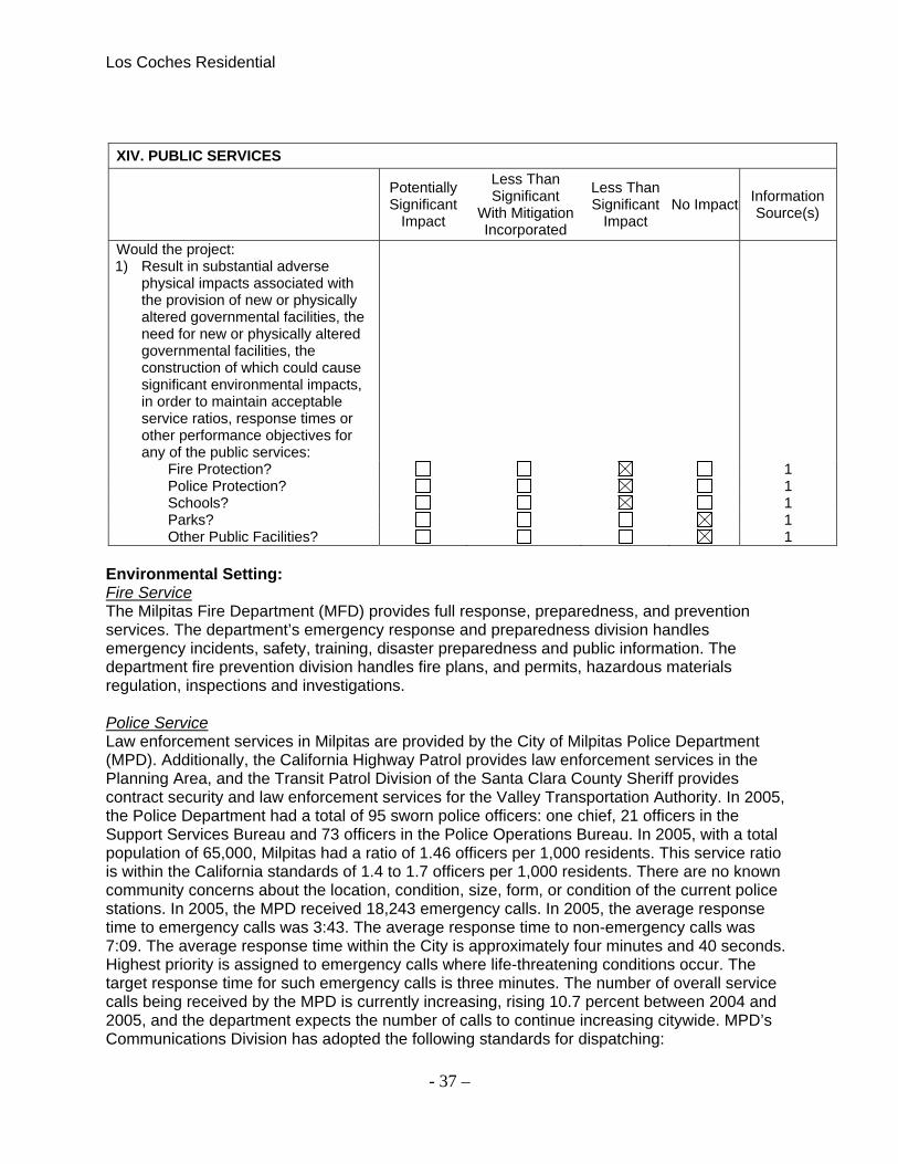
Los Coches Residential
- 37 –
XIV. PUBLIC SERVICES
Potentially Significant
Impact
Less Than Significant
With Mitigation Incorporated
Less Than Significant
Impact No Impact
Information Source(s)
Would the project: 1) Result in substantial adverse
physical impacts associated with the provision of new or physically altered governmental facilities, the need for new or physically altered governmental facilities, the construction of which could cause significant environmental impacts, in order to maintain acceptable service ratios, response times or other performance objectives for any of the public services:
Fire Protection? 1 Police Protection? 1 Schools? 1 Parks? 1 Other Public Facilities? 1
Environmental Setting: Fire Service The Milpitas Fire Department (MFD) provides full response, preparedness, and prevention services. The department’s emergency response and preparedness division handles emergency incidents, safety, training, disaster preparedness and public information. The department fire prevention division handles fire plans, and permits, hazardous materials regulation, inspections and investigations. Police Service Law enforcement services in Milpitas are provided by the City of Milpitas Police Department (MPD). Additionally, the California Highway Patrol provides law enforcement services in the Planning Area, and the Transit Patrol Division of the Santa Clara County Sheriff provides contract security and law enforcement services for the Valley Transportation Authority. In 2005, the Police Department had a total of 95 sworn police officers: one chief, 21 officers in the Support Services Bureau and 73 officers in the Police Operations Bureau. In 2005, with a total population of 65,000, Milpitas had a ratio of 1.46 officers per 1,000 residents. This service ratio is within the California standards of 1.4 to 1.7 officers per 1,000 residents. There are no known community concerns about the location, condition, size, form, or condition of the current police stations. In 2005, the MPD received 18,243 emergency calls. In 2005, the average response time to emergency calls was 3:43. The average response time to non-emergency calls was 7:09. The average response time within the City is approximately four minutes and 40 seconds. Highest priority is assigned to emergency calls where life-threatening conditions occur. The target response time for such emergency calls is three minutes. The number of overall service calls being received by the MPD is currently increasing, rising 10.7 percent between 2004 and 2005, and the department expects the number of calls to continue increasing citywide. MPD’s Communications Division has adopted the following standards for dispatching:

Los Coches Residential
- 38 –
9-1-1 calls shall be answered by Public Safety Dispatchers within 10 seconds at least 95 percent of the time.
Dispatch 95 percent of calls within 60 seconds of event creation in CAD. Dispatch 95 percent of non-emergency calls within 30 minutes of event creation
in CAD. Most of the crime that occurs in the Planning Area is specific to the Great Mall—thefts, forgery/fraud, and stolen vehicles—and there is little violent crime. In the rest of the Planning Area, more than half of the police-related calls are vehicle violations, traffic accidents, and theft from autos. Parks and Schools According to the Milpitas General Plan, the city has 161 acres of city owned parks and recreational facilities. Part of the 1,544-acre Ed Levin Regional Park is within City limits as well. The closest park within a walkable distance from the project site is Gill Park. Gill Park is an 8.16 acre park that includes a basketball court, three tennis courts, a softball field, and covered picnic area. Enrollment and Capacity In 2006-2007, enrollment in MUSD was approximately 5,043 elementary (grades K-6) school students, 1,462 middle school (grades 7-8) students, and 3,177 high school students, for a total of approximately 9,682 students. The total capacity for the district is 11,493 students, meaning that the district is at 84 percent of capacity overall. However, enrollment is not distributed evenly over school type. Using enrollment numbers from 2006/07, the MUSD elementary schools were at 88 percent of capacity (room for 690 additional students), middle schools were at 89 percent of capacity (room for 180 additional students), and the high school system of Milpitas High plus alternatives is at 95 percent of capacity (room for 165 additional students). MUSD’s enrollment projections through the year 2016 expect the district to see the addition of 2,312 students from 10,270 new housing units, including areas covered by the Transit Area Specific Plan and the Midtown Milpitas Specific Plan. The District is considering several approaches to handling the anticipated growth, all which involve the construction of a new elementary school and the expansion of existing facilities. Comment: Schools The number of new students generated the proposed project may or may not exceed the maximum amount of students allowed for the school. Since the provision of public school facilities is outside the control of the City, this is a significant and unavoidable impact, although one that can be mitigated by action from the Milpitas Unified School District. Fire Protection With the proposed development for 80 new single family residences, it is not expected that the Fire Department would have to expand. The project plans have been reviewed by fire and meets all fire prevention codes including the required street width for fire truck clearance in order to serve the residence in case of a fire. Police Services With the minor increase of 80 dwelling units, the long-term demand for police assistance and new staff and equipment should not be required. Parks

Los Coches Residential
- 39 –
The combination of Parks/Plazas and Linear Parks meets the expected park requirements for the proposed residential development. For more detail on parks see the Recreation section of this report. Conclusion The project would not result in significant impacts to public facilities. LS

Los Coches Residential
- 40 –
XV. RECREATION
Potentially Significant
Impact
Less Than Significant
With Mitigation Incorporated
Less Than Significant
Impact No Impact
Information Source(s)
Would the project:
1) Increase the use of existing neighborhood and regional parks or other recreational facilities such that substantial physical deterioration of the facility would occur or be accelerated?
1, 4, 8
2) Does the project include recreational facilities or require the construction or expansion of recreational facilities which might have an adverse physical effect on the environment?
1, 4, 8
Environmental Setting: The project proposal includes enhancing the existing public trail along Wrigley Creek, adding a new entrance trail entrance threw the residential development, and includes a passive 15,078 square foot private park for the residence. Comment: 1) Increase the use of existing neighborhood and regional parks or other recreational facilities such that substantial physical deterioration of the facility would occur or be accelerated? It is not expected that the addition of 80 residences will increase the use of existing parks that a physical deterioration of facilities would occur. 2) Does the project include recreational facilities or require the construction or expansion of recreational facilities which might have an adverse physical effect on the environment? Per the Milpitas Municipal Code, the project is required to have 0.64 private recreational open space and 0.96 acres of public park with an option of paying park-in-lieu fee. The park-in-lieu fee allows developers to pay a fee in lieu of building a public park. This option is allowed for projects where it is infeasible to construct the required public park. The fee goes into a joint parks fund where the City utilized the funds to create new parks or update existing facilities. The proposed project meets the private open space requirements and will be paying a park-in-lieu fee for the difference in park acres that they do not meet. Conclusion: The proposed residential development will have a less then significant impact on existing facilities. LS

Los Coches Residential
- 41 –
XVI. TRANSPORTATION/TRAFFIC
Potentially Significant
Impact
Less Than Significant
With Mitigation Incorporated
Less Than Significant
Impact No Impact
Information Source(s)
Would the project:
1) Exceed the capacity of the existing circulation system, based on an applicable measure of effectiveness (as designated in a general plan policy, ordinance, etc.), taking into account all relevant components of the circulation system, including but limited to intersections, streets, highways and freeways, pedestrian and bicycle paths, and mass transit?
1, 3
2) Conflict with an applicable congestion management program, including, but not limited to level of service standards and travel demand measures, or other standards established by the county congestion management agency for designated roads or highways?
1, 3
3) Result in a change in air traffic patterns, including either an increase in traffic levels or a change in location that results in substantial safety risks?
1
4) Substantially increase hazards due to a design feature (e.g., sharp curves or dangerous intersections) or incompatible land uses (e.g., farm equipment)?
1
5) Result in inadequate emergency access?
1
6) Conflict with adopted policies, plans, or programs supporting alternative transportation (e.g., bus turnouts, bicycle racks)?
1
Environmental Setting: The proposed project would include 80 single family dwellings and would be located on the northwest corner of the intersection of South Milpitas Blvd with Los Coches Street. All access to the site will be from a main entrance onto Los Coches Street with a secondary access onto Topaz Street (which is an extension of Los Coches Street). The proposed project includes a two car garage for each unit along with two uncovered spaces on the driveway to each unit. All traffic from the project will enter onto Los Coches Steret.
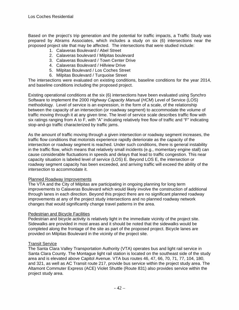
Los Coches Residential
- 42 –
Based on the project’s trip generation and the potential for traffic impacts, a Traffic Study was prepared by Abrams Associates, which includes a study on six (6) intersections near the proposed project site that may be affected. The intersections that were studied include:
1. Calaveras Boulevard / Abel Street 2. Calaveras boulevard / Milpitas boulevard 3. Calaveras Boulevard / Town Center Drive 4. Calaveras Boulevard / Hillview Drive 5. Milpitas Boulevard / Los Coches Street 6. Milpitas Boulevard / Turquoise Street
The intersections were evaluated on existing conditions, baseline conditions for the year 2014, and baseline conditions including the proposed project. Existing operational conditions at the six (6) intersections have been evaluated using Synchro Software to implement the 2000 Highway Capacity Manual (HCM) Level of Service (LOS) methodology. Level of service is an expression, in the form of a scale, of the relationship between the capacity of an intersection (or roadway segment) to accommodate the volume of traffic moving through it at any given time. The level of service scale describes traffic flow with six ratings ranging from A to F, with “A” indicating relatively free flow of traffic and “F” indicating stop-and-go traffic characterized by traffic jams. As the amount of traffic moving through a given intersection or roadway segment increases, the traffic flow conditions that motorists experience rapidly deteriorate as the capacity of the intersection or roadway segment is reached. Under such conditions, there is general instability in the traffic flow, which means that relatively small incidents (e.g., momentary engine stall) can cause considerable fluctuations in speeds and delays that lead to traffic congestion. This near capacity situation is labeled level of service (LOS) E. Beyond LOS E, the intersection or roadway segment capacity has been exceeded, and arriving traffic will exceed the ability of the intersection to accommodate it. Planned Roadway Improvements The VTA and the City of Milpitas are participating in ongoing planning for long term improvements to Calaveras Boulevard which would likely involve the construction of additional through lanes in each direction. Beyond this project there are no significant planned roadway improvements at any of the project study intersections and no planned roadway network changes that would significantly change travel patterns in the area. Pedestrian and Bicycle Facilities Pedestrian and bicycle activity is relatively light in the immediate vicinity of the project site. Sidewalks are provided in most areas and it should be noted that the sidewalks would be completed along the frontage of the site as part of the proposed project. Bicycle lanes are provided on Milpitas Boulevard in the vicinity of the project site. Transit Service The Santa Clara Valley Transportation Authority (VTA) operates bus and light rail service in Santa Clara County. The Montague light rail station is located on the southeast side of the study area and is elevated above Capitol Avenue. VTA bus routes 46, 47, 66, 70, 71, 77, 104, 180, and 321, as well as AC Transit route 217, provide bus service within the project study area. The Altamont Commuter Express (ACE) Violet Shuttle (Route 831) also provides service within the project study area.

Los Coches Residential
- 43 –
Bay Area Rapid Transit (BART) Bay Area Rapid Transit (BART) – BART is a rapid transit system which provides regional transportation connections to much of the Bay Area. It runs from the North Bay Area in Richmond to the South Bay Area in Fremont. In the east-west direction it runs from Pittsburg to the San Francisco Airport and Milbrae with several connections in Oakland. VTA bus service provides a connection to the Fremont BART station which provides regional access to San Francisco with several stops in Oakland where connections may be made to other lines. The Traffic Impact Study (see attachments) includes the impacts of previously approved projects within the area. Approved, not yet built, projects include 732 approved apartment units at 1200 Piper Drive (Citation), 303 approved apartment units at Milpitas Boulevard and the Montague Expressway (Milpitas Station), 80 approved single family dwellings on Sinclair Road (Sinclair Renaissance), 83 approved single family dwellings at 905-980 Los Coches Street (Robson Single Family), 375 approved apartment units and 148,805 square feet of approved commercial space at 600 Barber Lane (Landmark Tower), 366 approved apartment units at 1102 Abel Street (Centria West), and 204 approved apartment units at 1201 South Main Street (SD11-0011). To account for the baseline growth for this analysis (and a general background traffic increase to 2014) a 6 percent increase was applied to the existing traffic volumes. There is a proposed 30 unit residential project currently in the review process located on the southeast side of the project site. The estimated traffic from a proposed 30 unit residential project at 375 Los Coches Street was also included in the Traffic Analysis. Comment: The resulting trip rates used in the analysis were as follows: the AM Peak hour rate was 0.82 trips per unit, the PM peak hour rate was 1.07 trips per unit, and daily rate was 10.6 trips per unit. The trips from the project reflect all vehicle trips that would be counted at the project driveway on Los Coches Drive, both inbound and outbound. Since this project would be all residential there were no adjustments applied to account for pass-by or internal trips. The project is forecast to generate a total of 66 new vehicle trips during the AM peak hour and about 86 new trips during the PM peak hour. The site traffic is all assumed to use the main project entrance driveway on Los Coches Drive. Signalized Intersections - Project-related operational impacts on signalized intersections are considered significant if project-related traffic causes the Level of Service (LOS) rating to deteriorate from LOS D or better to LOS E or F on any City of Milpitas Roadways. The only exception are Congestion Management Plan (CMP) roadways such as Calaveras Boulevard where LOS E is permissible. All of the studied intersections would continue to have similar LOS results as the existing conditions, which are LOS E or better, and an acceptable condition during the AM and PM peak hours based on applicable standards. Conclusion: Based on the analysis within the Traffic Impact Study, the proposed project would not cause any intersections or roadways in the area to exceed established standards and would not create any safety problems. The highest peak hour trip generation at the project driveways would be about 86 vehicles during the PM peak hour. The project would not result in any significant traffic capacity or safety impacts and no off-site traffic mitigations would be required. The addition of project traffic at all signalized intersections would continue to operate at acceptable levels-of-service based on City and County standards. All of the project study

Los Coches Residential
- 44 –
intersections would continue to have similar LOS results as the Existing Conditions and no off-site mitigations would be required. All of the study intersections would continue to have acceptable conditions (according to applicable standards) during the AM and PM peak hours. The proposed project would not significantly impact any bicycle or pedestrian facilities, including bike lanes, routes, or paths. No internal site circulation or access issues have been identified that would cause a traffic safety problem or any unusual traffic congestion or delay. At the project entrances on Los Coches Street and Topasz Street the project’s side street approach should be controlled with a stop sign. The City’s Parking Ordinance requires 2.0 spaces per unit for residential unit with 3 or less bedrooms plus another 20% of the total required for guest parking. The project is currently proposing to meet the City’s parking requirement by providing two garage parking spaces per unit plus two additional uncovered spaces in the driveways to accommodate guest parking requirements. Based on our review of the proposed parking plan and a qualitative review of onstreet parking occupancy levels in the area there should be no significant impacts to the surrounding properties. Based on all the information given, the proposed project will have a less then significant impact to Traffic and Transportation.
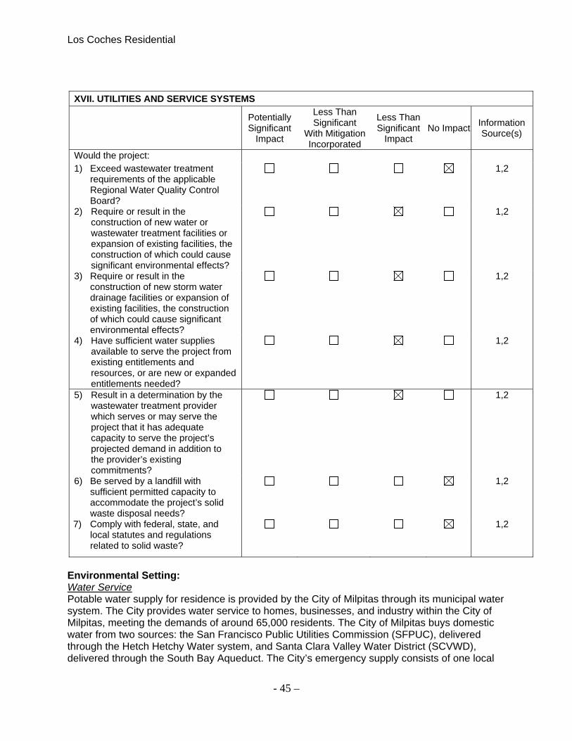
Los Coches Residential
- 45 –
XVII. UTILITIES AND SERVICE SYSTEMS
Potentially Significant
Impact
Less Than Significant
With Mitigation Incorporated
Less Than Significant
Impact No Impact
Information Source(s)
Would the project: 1) Exceed wastewater treatment
requirements of the applicable Regional Water Quality Control Board?
1,2
2) Require or result in the construction of new water or wastewater treatment facilities or expansion of existing facilities, the construction of which could cause significant environmental effects?
1,2
3) Require or result in the construction of new storm water drainage facilities or expansion of existing facilities, the construction of which could cause significant environmental effects?
1,2
4) Have sufficient water supplies available to serve the project from existing entitlements and resources, or are new or expanded entitlements needed?
1,2
5) Result in a determination by the wastewater treatment provider which serves or may serve the project that it has adequate capacity to serve the project’s projected demand in addition to the provider’s existing commitments?
1,2
6) Be served by a landfill with sufficient permitted capacity to accommodate the project’s solid waste disposal needs?
1,2
7) Comply with federal, state, and local statutes and regulations related to solid waste?
1,2
Environmental Setting: Water Service Potable water supply for residence is provided by the City of Milpitas through its municipal water system. The City provides water service to homes, businesses, and industry within the City of Milpitas, meeting the demands of around 65,000 residents. The City of Milpitas buys domestic water from two sources: the San Francisco Public Utilities Commission (SFPUC), delivered through the Hetch Hetchy Water system, and Santa Clara Valley Water District (SCVWD), delivered through the South Bay Aqueduct. The City’s emergency supply consists of one local

Los Coches Residential
- 46 –
groundwater wells—with a second one under construction—and three emergency interties, one with the San Jose Water Company and two with the Alameda County Water District. The City currently has a supply assurance amount from the SFPUC of 9.23 million gallons per day (mgd) or 10,340 acre-feet per year (AFY). This allocation could be reduced in drought years by SFPUC. In addition, it is anticipated that the incremental cost of water supplied by the SFPUC will become more expensive for the City to purchase should the allocation be increased. For these reasons, the City of Milpitas does not anticipate increasing allocations of SFPUC water at this time. Water supplied by SCVWD is derived in part from executed contracts with the State of California Department of Water Resources and the United States Bureau of Reclamation. The City’s contract with SCVWD allows for increases in purchased water to accommodate growth within the City. SCVWD bases its long-term water planning projections on employee and household projections provided by the Association of Bay Area Governments (ABAG). SCVWD responds to new land use plans by accommodating them in their projections for longterm water supply and demand. In accordance with the City’s contract, SCVWD provides exact delivery commitments on a three-year delivery schedule based, in part, on projections made by the City. Recycled water is also currently available in Milpitas through the South Bay Water Recycling Program (SBWRP). Wastewater The San Jose/Santa Clara Water Pollution Control Plant (WPCP) provides wastewater treatment for Milpitas and for several other cities and sanitary districts in the region. The WPCP is a regional facility located in San Jose. The cities of San Jose and Santa Clara jointly own the facility while San Jose operates and maintains the facilities. The WPCP first began operations in 1956 as a primary treatment facility and was upgraded to a tertiary treatment plant in 1964 and again in 1979. The WPCP currently provides primary, secondary and tertiary wastewater treatment (filtration, disinfectant and disinfectant removal). Currently, the City is discharging wastewater to the WPCP at a rate of between 8 and 9 mgd. The City’s most current wet weather (December 2006) discharge rate was 8.232 mgd2, down from a December 2005 peak week flow of 9.358 mgd.3 This current flow level is well below the City’s 13.5 mgd inflow limit at the WPCP. The WPCP discharges treated water to Artesian Slough, a tributary to Coyote Creek and the South San Francisco Bay. The WPCP must meet stringent regulatory disposal requirements, including heavy metal limits and maximum dry weather disposal levels intended to protect sensitive salt marshes. In the dry weather period of May through October, the WPCP is required by the San Francisco Regional Water Quality Control Board to limit discharge flows from the WPCP to 120 mgd ADWF (average dry weather flows), or to flows that would not further impact rare and endangered species habitat. The WPCP has had programs in place since 1991 to reduce and maintain flows below 120 mgd, and has maintained compliance with this requirement. The average dry weather effluent flow in the last year for which records are available is approximately 100 mgd.6 Long term plans to remain in compliance with the 120-mgd requirement include on-going water conservation and water recycling. Storm Drainage The City of Milpitas owns and maintains a system of underground pipes and a network of street gutters that convey flows from urban runoff to the San Francisco Bay. Within the Transit Area, the majority of stormwater runoff is conveyed to Berryessa Creek and Lower Penitencia Creek,

Los Coches Residential
- 47 –
with portions of the area draining into Wrigley-Ford Creek. Most major drainage facilities within the city, such as creeks and channels, are owned and maintained by SCVWD. Solid Waste The City of Milpitas disposes of all solid waste at the Permitted Class III, Subtitle D facility, the Newby Island Sanitary Landfill (NISL), administered by BFI. The Newby Island facility accepts solid waste, recyclables, and compostable materials. The NISL does not accept hazardous waste. The facility is 342 acres, of which waste has been placed on approximately 270 acres. The City’s contract with the NISL runs through 2017. Comment: The City’s Public Works Department reviewed the project and utility plans and is ensuring the infrastructure will allow for 80 new single family residence on this site by conditioning the project to meet their standards. Conclusion: The proposed project would not exceed the capacity of existing utilities and service systems. LS

Los Coches Residential
- 48 –
XVIII. MANDATORY FINDINGS OF SIGNIFICANCE
Potentially Significant
Impact
Less Than Significant
With Mitigation Incorporated
Less Than Significant
Impact No Impact
Information Source(s)
1) Does the project have the potential to degrade the quality of the environment, substantially reduce the habitat of a fish or wildlife species, cause a fish or wildlife population to drop below self-sustaining levels, threaten to eliminate a plant or animal community, reduce the number or restrict the range of a rare or endangered plant or animal or eliminate important examples of the major periods of California history or prehistory?
1-15, A
2) Does the project have impacts that are individually limited, but cumulatively considerable? (“Cumulatively considerable” means that the incremental effects of a project are considerable when viewed in connection with the effects of past projects, the effects of other current projects, and the effects of probable future projects)?
1-15, A, B
3) Does the project have the potential to achieve short-term environmental goals to the disadvantage of long-term environmental goals?
1-15, A
4) Does the project have environmental effects which will cause substantial adverse effects on human beings, either directly or indirectly?
1-15, A
Conclusion: With the implementation of the Mitigation Measures included in the project and described in the specific sections of this report, the proposed construction of 80 single family residential homes would not result in a significant environmental impact. LS

Los Coches Residential
- 49 –
SOURCES General Sources: 1. CEQA Guidelines - Environmental Thresholds (Professional judgment and expertise and review
of project plans) 2. City of Milpitas General Plan (Land Use Chapter) 3. City of Milpitas General Plan (Circulation Chapter) 4. City of Milpitas General Plan (Open Space & Environmental Conservation Chapter) 5. City of Milpitas General Plan (Seismic and Safety Chapter) 6. City of Milpitas General Plan (Noise Chapter) 7. City of Milpitas General Plan (Housing Chapter) 8. City of Milpitas Zoning (Title XI) 9. California Department of Conservation, Santa Clara County Important Farmland 2006, Map.
June 2005 10. Bay Area Air Quality Management District, CEQA Guidelines, June 2010 11. County of Santa Clara Department of Public Works, Soil Map Sheet 19, 1964 12. United States Department of Agriculture, Soil Conservation Service, Soils of Santa Clara County,
1968 13. California Department of Conservation, Geologic Map of the San Francisco-San José
Quadrangle, 1990 14. Federal Emergency Management Agency, Flood Insurance Rate Map, Community Panel Nos.
06085CIND0A, 06085C0058H, 06085C0059H, 06085C0066H, 06085C0067H, 06085C0068H, 06085C0069H.06085C0080H, 06085C0086H, and 06085C0087H
15. Project Related Sources:
A. Project application and plans B. Traffic Study C. Phase I and Phase II Environmental Impact Assessment(s) D. Sub-Slab Vapor and Groundwater Assessment E. Vapor Intrusion Risk Assessment F. Greenhouse Gas / Air Quality Technical Report G. Environmental Noise & Vibration Assessment H. Union Pacific Railroad Corporation (UPRC) Future Lighting Plans
Note: Authority cited: Sections 21083, 21083.05, Public Resources Code. Reference: Section 65088.4, Gov. Code; Sections 21080, 21083.05, 21095, Pub. Resources Code; Eureka Citizens for Responsible Govt. v. City of Eureka (2007) 147 Cal.App.4th 357; Protect the Historic Amador Waterways v. Amador Water Agency (2004) 116 Cal.App.4th at 1109; San Franciscans Upholding the Downtown Plan v. City and County of San Francisco (2002) 102 Cal.App.4th 656.


![Review[1] coches y subjuntivo](https://img.pdfslide.us/doc/110x75/55644bd3d8b42a9f128b51a3/review1-coches-y-subjuntivo.jpg)