Embed Size (px)
Citation preview
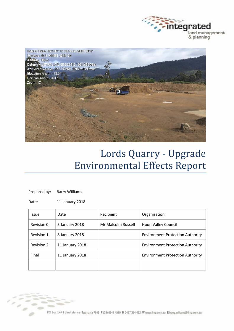
Lords Quarry - Upgrade Environmental Effects Report
Prepared by: Barry Williams
Date: 11 January 2018
Issue Date Recipient Organisation
Revision 0 3 January 2018 Mr Malcolm Russell Huon Valley Council
Revision 1 8 January 2018 Environment Protection Authority
Revision 2 11 January 2018 Environment Protection Authority
Final 11 January 2018 Environment Protection Authority
Lords Quarry Upgrade – Environmental Effects Report Final
Integrated Land Management and Planning | Table of contents 2
This Plan is based entirely on information available to ILMP at the time of its creation. ILMP accepts
no liability for any loss or damage, whether direct or indirect, in the event that not all relevant
information that the Principal knows or should have known is provided to ILMP prior to the
implementation of this Plan.
TABLE OF CONTENTS
Table of contents .................................................................................................................................... 2
Figures ................................................................................................................................................. 4
Tables .................................................................................................................................................. 4
Part A proponent information ................................................................................................................ 5
2 Proponent Details ........................................................................................................................... 5
Part B – Proposal description .................................................................................................................. 5
1 Description of proposed activity ..................................................................................................... 6
1.1 Method of operation .............................................................................................................. 6
1.2 Industry standards .................................................................................................................. 7
1.3 Activity timeframe .................................................................................................................. 8
2 Proposal area .................................................................................................................................. 8
2.1 Description of the site ............................................................................................................. 9
2.2 Climate .................................................................................................................................. 10
2.3 Properties adjacent to and surrounding ............................................................................... 11
3 Map and site plan ......................................................................................................................... 12
4 Rationale and alternatives ............................................................................................................ 14
4.1 Economic ............................................................................................................................... 14
4.2 Social ..................................................................................................................................... 14
5 Planning information .................................................................................................................... 14
6 Existing activity.............................................................................................................................. 14
Part C – Potential Environmental Effects .............................................................................................. 16
1 Flora and fauna ............................................................................................................................. 16
1.1 Vegetation clearing ............................................................................................................... 16
1.2 Native vegetation communities ............................................................................................ 16
1.3 Native fauna .......................................................................................................................... 17
1.4 Weeds ................................................................................................................................... 18
2 Aquatic environment and stormwater ......................................................................................... 18
2.1 Existing situation ................................................................................................................... 18
Lords Quarry Upgrade – Environmental Effects Report Final
Integrated Land Management and Planning | Table of contents 3
2.2 Additional infrastructure....................................................................................................... 19
3 Significant areas ............................................................................................................................ 20
4 Air emissions ................................................................................................................................. 21
4.1 Air emission sources ............................................................................................................. 21
4.2 Receptors sensitive to air emissions ..................................................................................... 21
4.3 Mitigation measures to control dust .................................................................................... 21
5 Liquid effluent ............................................................................................................................... 22
6 Solid waste .................................................................................................................................... 22
7 Noise emissions ............................................................................................................................. 23
8 Transport impacts ......................................................................................................................... 24
9 Other Off-site Impacts .................................................................................................................. 25
10 Hazardous Substances .............................................................................................................. 25
11 Site Contamination (Historical) ................................................................................................. 25
12 Climate Change ......................................................................................................................... 26
13 Heritage ..................................................................................................................................... 26
13.1 Historic heritage .................................................................................................................... 26
13.2 Aboriginal heritage ................................................................................................................ 26
14 Sites of high public interest ....................................................................................................... 26
15 Monitoring ................................................................................................................................ 26
15.1 Air emissions ......................................................................................................................... 26
15.2 Sediment trap ....................................................................................................................... 26
16 Rehabilitation ............................................................................................................................ 27
16.1 Objective ............................................................................................................................... 27
16.2 Progressive rehabilitation ..................................................................................................... 27
16.3 Decommissioning and rehabilitation .................................................................................... 27
Part D Management commitments ...................................................................................................... 28
Part E – Public and Stakeholder Consultation....................................................................................... 29
17 References ................................................................................................................................ 30
Appendix 1 -Lords Quarry – Noise Assessment, Noise Vibration Consulting ....................................... 31
Lords Quarry Upgrade – Environmental Effects Report Final
Integrated Land Management and Planning | Table of contents 4
FIGURES
Figure 1: Schematic of process ............................................................................................................... 7
Figure 2: Locality Plan (Extract from TasMap Topographic Huonville 5023) .......................................... 8
Figure 3: Lords Quarry - mining plan .................................................................................................... 12
Figure 4: Section views.......................................................................................................................... 13
TABLES
Table 1: Proponent details ...................................................................................................................... 5
Table 2: Consultant preparing environmental effects report ................................................................. 5
Table 3: Project Title ............................................................................................................................... 5
Table 4: Proposal area ............................................................................................................................ 6
Table 5: Main pieces of equipment used ................................................................................................ 7
Table 6: Possible project time line .......................................................................................................... 8
Table 7: Operating hours ........................................................................................................................ 8
Table 8: Project Details ........................................................................................................................... 8
Table 9: Climate data ............................................................................................................................ 10
Table 10: Property Details ..................................................................................................................... 11
Table 11: properties adjacent to HVC parcel ........................................................................................ 11
Table 12: Existing operational permit conditions ................................................................................. 15
Table 13: Listed flora species within 5 kilometres ................................................................................ 16
Table 14: Listed flauna species within 500 metres ............................................................................... 17
Table 15: Listed fauna species within 5 kilometres .............................................................................. 17
Table 16: Weeds casually observed on site .......................................................................................... 18
Table 17: Time of concentration ........................................................................................................... 19
Table 18: Flow rate ............................................................................................................................... 19
Table 19: Retention Basin surface areas ............................................................................................... 20
Table 20: Clean out frequency .............................................................................................................. 20
Table 21: Separation distance to residences ........................................................................................ 21
Table 22: Maximum acceptable noise levels ........................................................................................ 23
Table 23: Traffic movements ................................................................................................................ 24
Lords Quarry Upgrade – Environmental Effects Report Final
Integrated Land Management and Planning | Part A proponent information 5
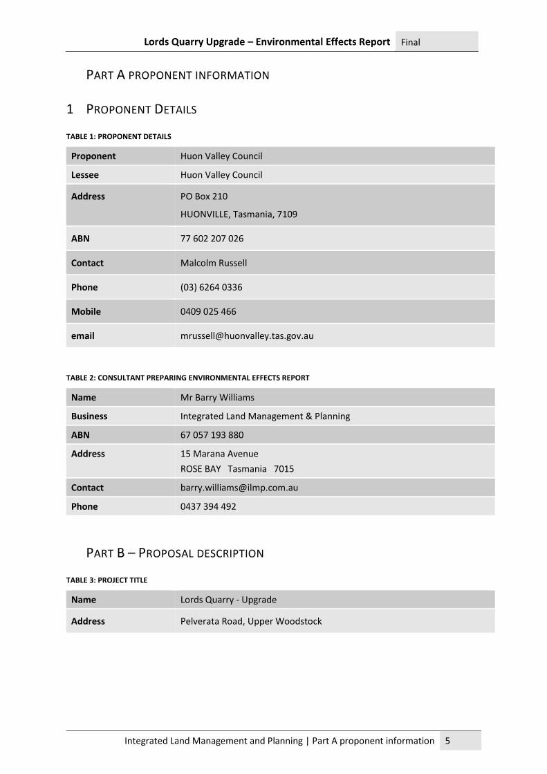
PART A PROPONENT INFORMATION
1 PROPONENT DETAILS
TABLE 1: PROPONENT DETAILS
Proponent Huon Valley Council
Lessee Huon Valley Council
Address PO Box 210
HUONVILLE, Tasmania, 7109
ABN 77 602 207 026
Contact Malcolm Russell
Phone (03) 6264 0336
Mobile 0409 025 466
email [email protected]
TABLE 2: CONSULTANT PREPARING ENVIRONMENTAL EFFECTS REPORT
Name Mr Barry Williams
Business Integrated Land Management & Planning
ABN 67 057 193 880
Address 15 Marana Avenue
ROSE BAY Tasmania 7015
Contact [email protected]
Phone 0437 394 492
PART B – PROPOSAL DESCRIPTION
TABLE 3: PROJECT TITLE
Name Lords Quarry - Upgrade
Address Pelverata Road, Upper Woodstock
Lords Quarry Upgrade – Environmental Effects Report Final
Integrated Land Management and Planning | Description of proposed activity 6
1 DESCRIPTION OF PROPOSED ACTIVITY A Mining Lease (1797P/M) was granted in June 2005 to Huon Valley Council for a weathered dolerite
quarry producing road gravel off Pelverata Road at Upper Woodbridge. The quarry has operated
since granting as a Level 1 operation by Huon Valley Council for the purpose of supplying road and
shoulder gravel for the municipality’s annual road construction and maintenance program.
Lords Quarry is an important source of red gravel products located in the northern portion of the
municipality. Huon Valley Council (Proponent) is well experienced in the operation of quarries having
successfully operated 12 sites with individual mining leases at different times since the early 90s and
others previously.
TABLE 4: PROPOSAL AREA
Existing area of disturbance 3.1 hectares
Area of expansion 0.9 hectares
Total area of un-rehabilitated land required for this proposal 4.0 hectares
1.1 METHOD OF OPERATION The Proponent is seeking approval to upgrade Lords Quarry to increase the maximum permitted
production from 5 000 m3 to 20 000 m3 per annum, which equates to approximately 32 000 tonnes.
In the existing area of extraction the source rock from Lords Quarry has a high clay component. To
provide the necessary strength for road sheeting an amount of hard rock is introduced from a
nearby quarry. The need for extraneous products may not be necessary as expansion proceeds.
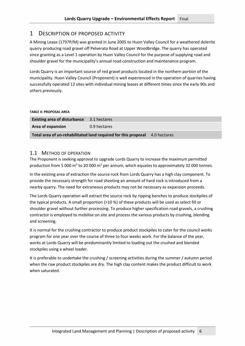
The Lords Quarry operation will extract the source rock by ripping benches to produce stockpiles of
the typical products. A small proportion (>10 %) of these products will be used as select fill or
shoulder gravel without further processing. To produce higher specification road gravels, a crushing
contractor is employed to mobilise on site and process the various products by crushing, blending
and screening.
It is normal for the crushing contractor to produce product stockpiles to cater for the council works
program for one year over the course of three to four weeks work. For the balance of the year,
works at Lords Quarry will be predominantly limited to loading out the crushed and blended
stockpiles using a wheel loader.
It is preferable to undertake the crushing / screening activities during the summer / autumn period
when the raw product stockpiles are dry. The high clay content makes the product difficult to work
when saturated.
Lords Quarry Upgrade – Environmental Effects Report Final
Integrated Land Management and Planning | Description of proposed activity 7
FIGURE 1: SCHEMATIC OF PROCESS
TABLE 5: MAIN PIECES OF EQUIPMENT USED
description Make Model Size Power rating (kW)
Loader CAT 966h 216
Excavator Komatsu Pc 350 - 8 224
Primary crusher Metro jaw 119
Secondary Maxtrack 1000 Cone 242
Alt. secondary Maxtrack Vsi impactor 224
1.2 INDUSTRY STANDARDS The Proponent will undertake quarry operations in compliance with all relevant codes, standards
and conditions introduced by the Environment Protection Authority, Huon Valley Council and lease
conditions applied by Mineral Resources Tasmania. Guiding legislation, policies and codes are
detailed below:
• Environmental Management and Pollution Control Act 1994 (EMPCA)
• Land Use Planning and Approvals Act 1993 (LUPAA)
• Mineral Resources Development Act 1995 (MRDA)
• State Policy on Water Quality Management 1997
• Environment Protection Policy (Air Quality) 2004
• Environment Protection Policy (Noise) 2009
• Quarry Code of Practice, 3rd Edition, May 2017
Extraction
Crushing screening
Stockpile Load out for delivery
Small proportion delivered as select fill
Lords Quarry Upgrade – Environmental Effects Report Final
Integrated Land Management and Planning | Proposal area 8
1.3 ACTIVITY TIMEFRAME Lords Quarry will continue to operate under the existing permit arrangements until a new permit is
issued. To ensure the Council’s construction and maintenance program can proceed for the 2018
season, it is essential that contract crushing occurs before the wet weather commences, at the latest
in March.
From that point the quarry continues to operate within the existing footprint extracting the first
bench. Once this resource is exhausted a small area of clearing will facilitate development of the
second bench.
TABLE 6: POSSIBLE PROJECT TIME LINE
Continue under ex. permit
New Permit issued
Extraction 1st bench Clear 0.9 ha Extraction 2nd bench
Up to 5 000 m3 Up to 20 000 m3 100 000 m3 350 000 m3
Dec 17 – Mar 18 Mar 18 at max. prod.2025 2026 at max. prod. 2045
TABLE 7: OPERATING HOURS
Hours of Operation
Weekdays: 7.00 am to 7.00 pm
Saturdays: 8.00 am to 4.00 pm
Sundays, public holidays: No work
TABLE 8: PROJECT DETAILS
Project Name Lords Quarry - Upgrade
Maximum annual production 20 000 m3 per year of product
2 PROPOSAL AREA
FIGURE 2: LOCALITY PLAN (EXTRACT FROM TASMAP TOPOGRAPHIC HUONVILLE 5023)
Lords Quarry 1797 P/M
Lords Quarry Upgrade – Environmental Effects Report Final
Integrated Land Management and Planning | Proposal area 9
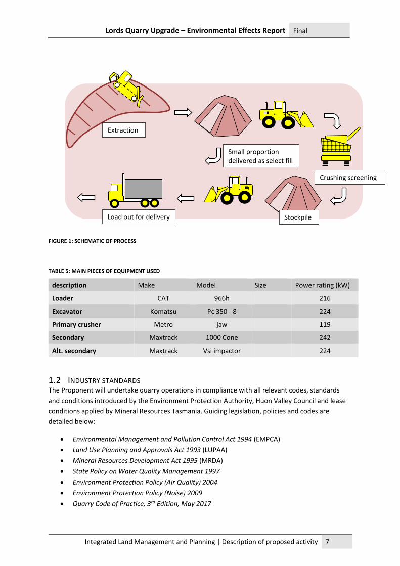
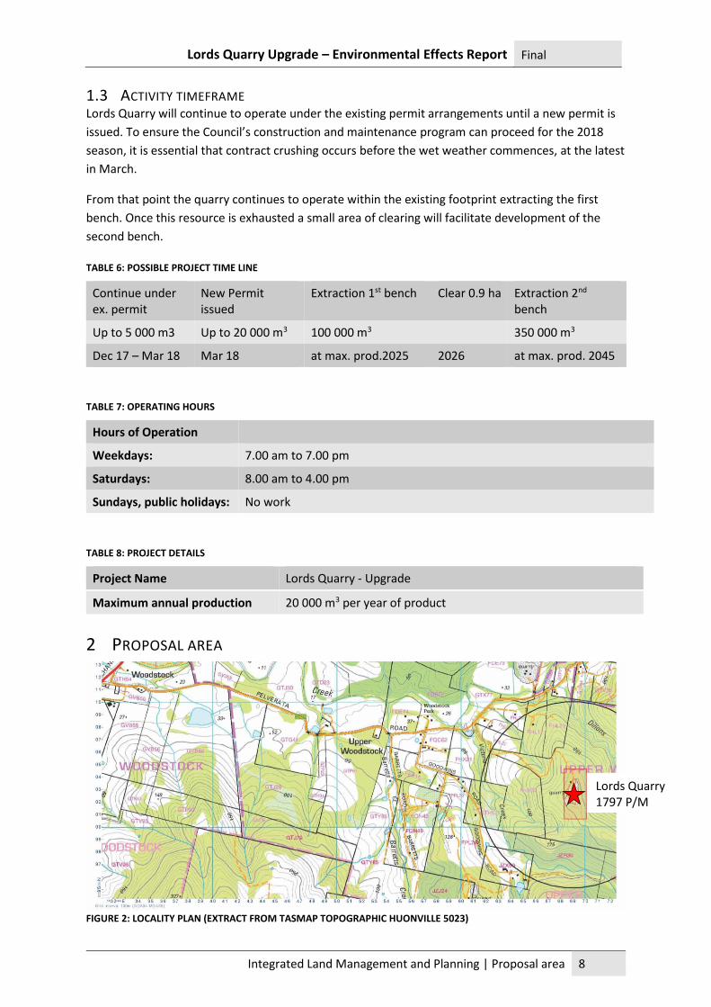
2.1 DESCRIPTION OF THE SITE Lords Quarry is located approximately 6 kilometres southeast of the township of Huonville. The site
is situated on a ridgetop on the foothills to Grey Mountain. The Mining Lease encompasses land
from an elevation of 180 metres (AHD1) to 210 m.
Natural watercourses run in the valleys either side of the site. To the east is a tributary to Dillons
Creek which has a unique river reach identifier of 228094 and is located 250 metres away. Under the
Conservation of Freshwater Ecosystem Values (CFEV) program2 this water course has an integrated
conservation value (ICV) of High. Two watercourses in the valleys to the west are identified as
228290 which is a tributary to Kellaways Creek and 228319 which is a tributary to Victoria Creek.
Both these watercourse reaches have an ICV of Moderate. The former watercourse is located 200
metres from the quarry and the latter is 225 metres away.
The quarry site is surrounded by low forest and woodland mapped by the TasVeg3 database as
predominantly Eucalyptus pulchella dry forest and woodland (DPU). Eucalyptus obliqua dry forest
(DOB) occurs on the southern slope towards the north west corner of the quarry site. Adjacent to
the DOB forest is an area mapped as Eucalyptus globulus dry forest and woodland (DGL) although
the edge of the mapped boundary of this community is on the mining lease boundary.
PLATE 1: SECOND BENCH WITH E. PULCHELLA FOREST BEHIND
1 AHD – Australian Height Datum 2 The Conservation of Freshwater Ecosystem Values (CFEV) (pronounced program is an initiative of the Department of Primary Industries, Parks, Water and Environment (DPIPWE). Its aim is to ensure that priority freshwater values are appropriately considered in the development, management and conservation of the state's water resources. 3 TASVEG is prepared by DPIPWE as a comprehensive digital map of Tasmania's vegetation, including sub-Antarctic Macquarie Island. The map depicts the extent of more than 150 vegetation communities, including coastal heathlands, eucalypt forest and alpine communities.
Lords Quarry Upgrade – Environmental Effects Report Final
Integrated Land Management and Planning | Proposal area 10
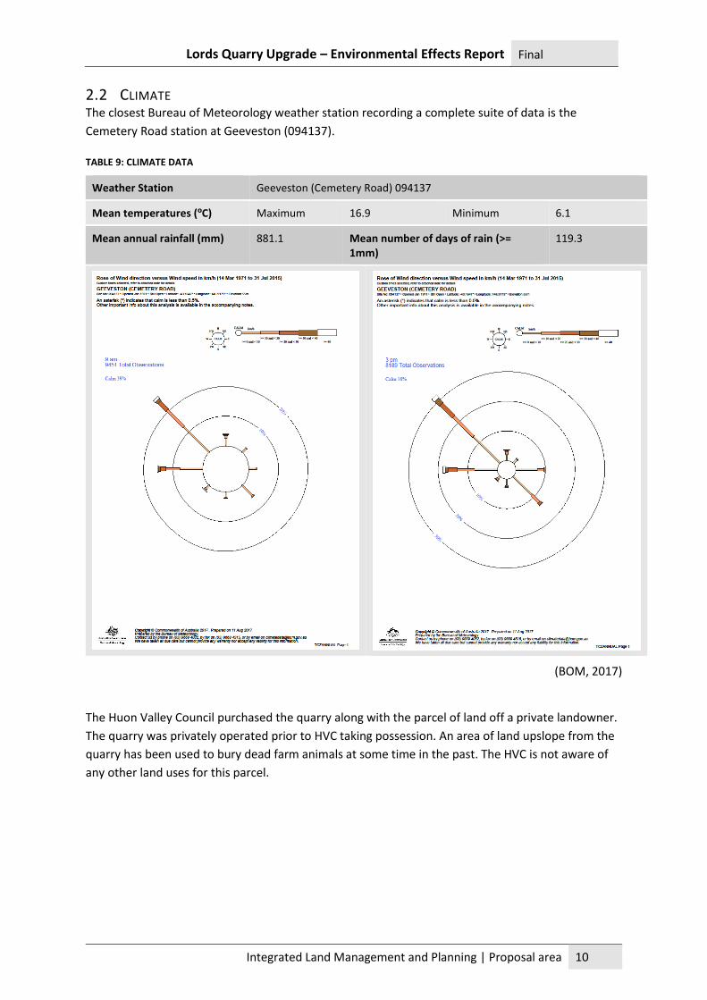
2.2 CLIMATE The closest Bureau of Meteorology weather station recording a complete suite of data is the
Cemetery Road station at Geeveston (094137).
TABLE 9: CLIMATE DATA
Weather Station Geeveston (Cemetery Road) 094137
Mean temperatures (ºC) Maximum 16.9 Minimum 6.1
Mean annual rainfall (mm) 881.1 Mean number of days of rain (>= 1mm)
119.3
(BOM, 2017)
The Huon Valley Council purchased the quarry along with the parcel of land off a private landowner.
The quarry was privately operated prior to HVC taking possession. An area of land upslope from the
quarry has been used to bury dead farm animals at some time in the past. The HVC is not aware of
any other land uses for this parcel.
Lords Quarry Upgrade – Environmental Effects Report Final
Integrated Land Management and Planning | Proposal area 11
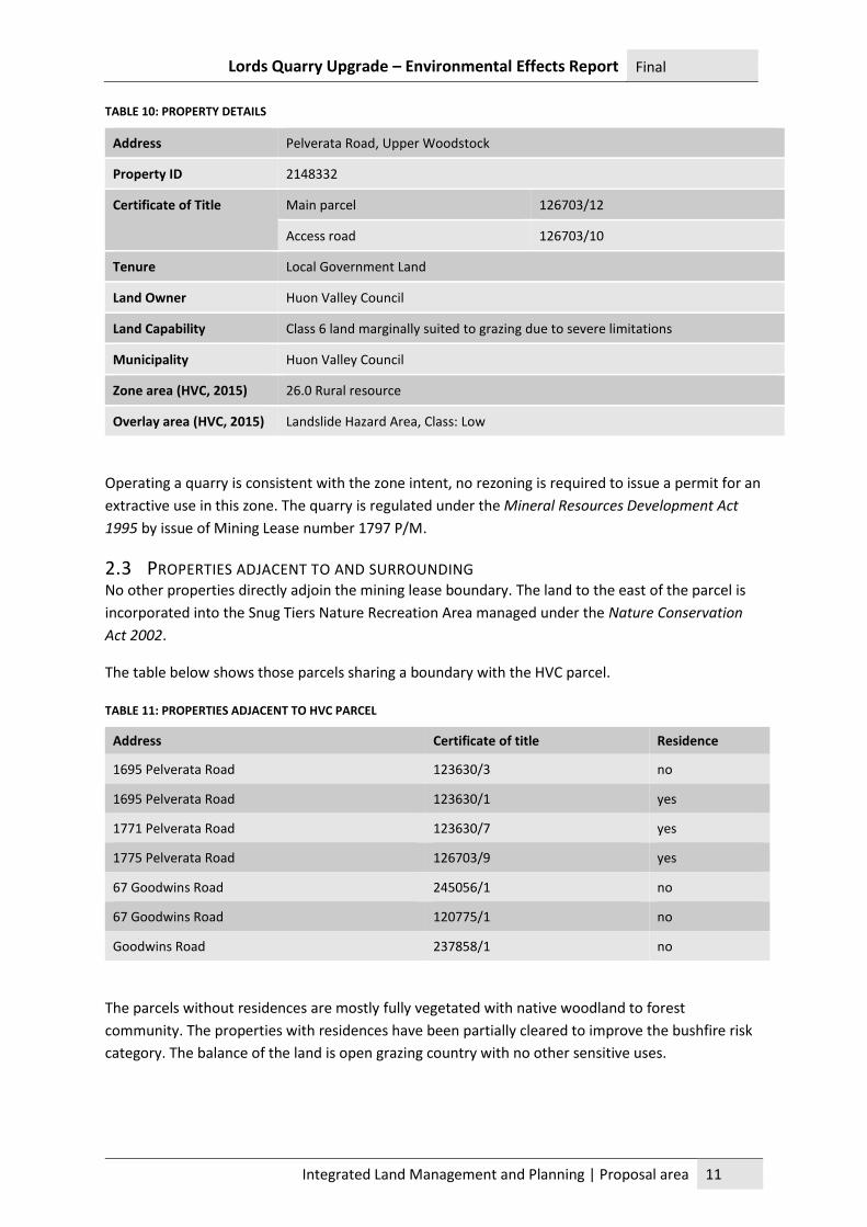
TABLE 10: PROPERTY DETAILS
Address Pelverata Road, Upper Woodstock
Property ID 2148332
Certificate of Title Main parcel 126703/12
Access road 126703/10
Tenure Local Government Land
Land Owner Huon Valley Council
Land Capability Class 6 land marginally suited to grazing due to severe limitations
Municipality Huon Valley Council
Zone area (HVC, 2015) 26.0 Rural resource
Overlay area (HVC, 2015) Landslide Hazard Area, Class: Low
Operating a quarry is consistent with the zone intent, no rezoning is required to issue a permit for an
extractive use in this zone. The quarry is regulated under the Mineral Resources Development Act
1995 by issue of Mining Lease number 1797 P/M.
2.3 PROPERTIES ADJACENT TO AND SURROUNDING No other properties directly adjoin the mining lease boundary. The land to the east of the parcel is
incorporated into the Snug Tiers Nature Recreation Area managed under the Nature Conservation
Act 2002.
The table below shows those parcels sharing a boundary with the HVC parcel.
TABLE 11: PROPERTIES ADJACENT TO HVC PARCEL
Address Certificate of title Residence
1695 Pelverata Road 123630/3 no
1695 Pelverata Road 123630/1 yes
1771 Pelverata Road 123630/7 yes
1775 Pelverata Road 126703/9 yes
67 Goodwins Road 245056/1 no
67 Goodwins Road 120775/1 no
Goodwins Road 237858/1 no
The parcels without residences are mostly fully vegetated with native woodland to forest
community. The properties with residences have been partially cleared to improve the bushfire risk
category. The balance of the land is open grazing country with no other sensitive uses.
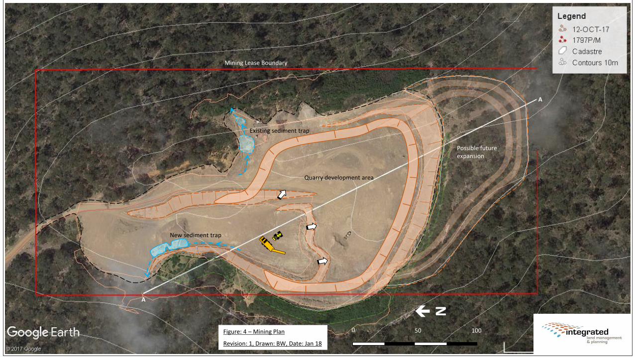
Quarry development area
New sediment trap
Possible future expansion
Existing sediment trap
Figure: 4 – Mining Plan
Revision: 1, Drawn: BW, Date: Jan 18
N
0 50 100
Mining Lease Boundary
A
A
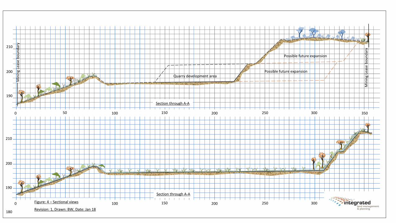
0 100 200 300 35025015050
190
200
210
0 100 200 300 35025015050
Quarry development area
Possible future expansion
Min
ing
Leas
e b
ou
nd
ary
Min
ing
Leas
e b
ou
nd
ary
Section through A-A
Possible future expansion
Section through A-A
Figure: 4 – Sectional views
Revision: 1, Drawn: BW, Date: Jan 18180
190
200
210
Lords Quarry Upgrade – Environmental Effects Report Final
Integrated Land Management and Planning | Rationale and alternatives 14
4 RATIONALE AND ALTERNATIVES
4.1 ECONOMIC The Huon Valley Council is undertaking a strategic rationalisation of its quarry holdings. The
objective is to concentrate effort in developing key operations and surrendering those less used and
less viable operations. The outcome will be to target the Council’s resources on a small number of
well-run quarries with extensive future reserves. A reduced number of legacy operations will save
the Council money and enable the same resources to be better utilised on a smaller number of sites.
4.2 SOCIAL The Huon Valley Council has embarked on this program of rationalisation and development to
improve efficiency in the delivery of Council services. The ratepayers of Huon Valley municipal area
will ultimately benefit from a more efficient service delivery.
5 PLANNING INFORMATION Environmental aspects of the proposed upgrade of Lords Quarry will be assessed by the Board of the
Environment Protection Authority. The final permit will be issued by Huon Valley Council acting as
the Planning Authority. The Planning Authority has been consulted with regard to this proposal and
has determined that the upgrade cannot be treated as a minor amendment to the existing permit
and hence a new permit is required.
(a) A permit under the Land Use Planning and Approvals Act 1993 (LUPAA) is required.
(b) A single permit application will be lodged with the Huon Valley Council.
(c) The application will be made under Section 57 of LUPAA, meaning the application will be
‘discretionary’.
(d) The land for the development site is zoned as Rural Resource. The development of extractive
industries is consistent with the intent of the zone. No rezoning will be required.
(e) Intensification of the existing permitted use being Extractive Industries is still consistent with
the Rural Resource Zone intent and hence does not require a planning scheme amendment.
As stated under Section 10 of the Notice of Intent, referral to the Commonwealth Government for
approval under the EPBCA is not warranted. Therefore, assessment pursuant to the Bilateral
Agreement made under section 45 of the EPBCA is not required.
6 EXISTING ACTIVITY The existing quarry operation has continued without any known public complaints received by
council or regulators, any breaches of the operational conditions or regulatory approvals or
contraventions of environmental law.
The overburden stockpiles on the western perimeter of the quarry extend slightly outside the mining
lease boundary, but the slopes are fully vegetated and stable and pose no threat.
Lords Quarry Upgrade – Environmental Effects Report Final
Integrated Land Management and Planning | Existing activity 15
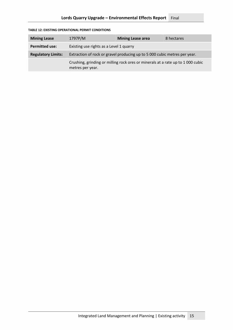
TABLE 12: EXISTING OPERATIONAL PERMIT CONDITIONS
Mining Lease 1797P/M Mining Lease area 8 hectares
Permitted use: Existing use rights as a Level 1 quarry
Regulatory Limits: Extraction of rock or gravel producing up to 5 000 cubic metres per year.
Crushing, grinding or milling rock ores or minerals at a rate up to 1 000 cubic metres per year.
Lords Quarry Upgrade – Environmental Effects Report Final
Integrated Land Management and Planning | Part C – Potential Environmental Effects 16
PART C – POTENTIAL ENVIRONMENTAL EFFECTS
1 FLORA AND FAUNA
1.1 VEGETATION CLEARING Lords Quarry has ample area to expand its operation within the existing footprint of the quarry.
Expanding the lower bench toward the east will yield approximately 100 000 cubic metres. However,
during the projected life of the quarry, it may be necessary to expand further east, clearing a portion
of highly disturbed native woodland on the crest of the ridge. The total area cleared will be
constrained by the mining lease and hence will be small at around 0.9 hectares. This area is located
away from the important swift parrot foraging habitat and in an area of the surrounding vegetation
which is already heavily disturbed.
1.2 NATIVE VEGETATION COMMUNITIES Lords Quarry is surrounded by native woodland and forest. Eucalyptus globulus forest is important
foraging habitat for swift parrot. TasVeg 3.0 mapping identifies an area of forest on the western
boundary of the mining lease as (DGL) Eucalyptus globulus dry forest and woodland. This community
is listed as a threatened community under the Nature Conservation Act 2002. There is no proposal to
expand the quarry in this direction. There will be no impact on this community.
There are no observations of flora species listed under commonwealth or state legislation within 500
metres of the quarry site. A diverse array of communities is exhibited within 5 kilometres of the
quarry site. There are observations of flora species listed under commonwealth and state legislation
within 5 kilometres of the site.
TABLE 13: LISTED FLORA SPECIES WITHIN 5 KILOMETRES
Species Common name State listing National listing Date
Allocasuarina duncanii conical sheoak rare - 2017
Deyeuxia minor small bentgrass rare - 2010
Dryopoa dives tasmanian giant mountaingrass rare - 2010
Juncus amabilis gentle rush rare - 2010
Prasophyllum amoenum dainty leek-orchid vulnerable endangered 2011
Westringia angustifolia narrowleaf westringia rare - 2012
There is a single observation site located on the south west corner of the mining lease boundary
with a series of observations attached to it. Importantly the observations listed include swift parrot,
a species which is linked to the E. globulus community on the boundary of the mining lease; there is
no proposal to disturb this community.
The quarry is an existing operation, which has continued for at least 20 years in the same location
and substantially in the same manner. The new permit will allow an increase in the quantity of
Lords Quarry Upgrade – Environmental Effects Report Final
Integrated Land Management and Planning | Flora and fauna 17
product processed through crushing and screening, but these changes are unlikely to substantially
change the impact of the operation on the surrounding woodlands.
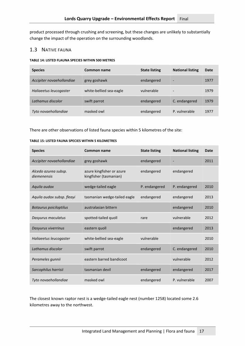
1.3 NATIVE FAUNA
TABLE 14: LISTED FLAUNA SPECIES WITHIN 500 METRES
Species Common name State listing National listing Date
Accipiter novaehollandiae grey goshawk endangered - 1977
Haliaeetus leucogaster white-bellied sea-eagle vulnerable - 1979
Lathamus discolor swift parrot endangered C. endangered 1979
Tyto novaehollandiae masked owl endangered P. vulnerable 1977
There are other observations of listed fauna species within 5 kilometres of the site:
TABLE 15: LISTED FAUNA SPECIES WITHIN 5 KILOMETRES
Species Common name State listing National listing Date
Accipiter novaehollandiae grey goshawk endangered - 2011
Alcedo azurea subsp. diemenensis
azure kingfisher or azure kingfisher (tasmanian)
endangered endangered
Aquila audax wedge-tailed eagle P. endangered P. endangered 2010
Aquila audax subsp. fleayi tasmanian wedge-tailed eagle endangered endangered 2013
Botaurus poiciloptilus australasian bittern endangered 2010
Dasyurus maculatus spotted-tailed quoll rare vulnerable 2012
Dasyurus viverrinus eastern quoll endangered 2013
Haliaeetus leucogaster white-bellied sea-eagle vulnerable 2010
Lathamus discolor swift parrot endangered C. endangered 2010
Perameles gunnii eastern barred bandicoot vulnerable 2012
Sarcophilus harrisii tasmanian devil endangered endangered 2017
Tyto novaehollandiae masked owl endangered P. vulnerable 2007
The closest known raptor nest is a wedge-tailed eagle nest (number 1258) located some 2.6
kilometres away to the northwest.
Lords Quarry Upgrade – Environmental Effects Report Final
Integrated Land Management and Planning | Aquatic environment and stormwater 18
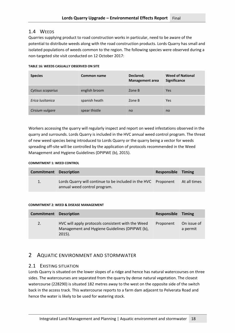
1.4 WEEDS Quarries supplying product to road construction works in particular, need to be aware of the
potential to distribute weeds along with the road construction products. Lords Quarry has small and
isolated populations of weeds common to the region. The following species were observed during a
non-targeted site visit conducted on 12 October 2017:
TABLE 16: WEEDS CASUALLY OBSERVED ON SITE
Species Common name Declared; Management area
Weed of National Significance
Cytisus scoparius english broom Zone B Yes
Erica lusitanica spanish heath Zone B Yes
Cirsium vulgare spear thistle no no
Workers accessing the quarry will regularly inspect and report on weed infestations observed in the
quarry and surrounds. Lords Quarry is included in the HVC annual weed control program. The threat
of new weed species being introduced to Lords Quarry or the quarry being a vector for weeds
spreading off-site will be controlled by the application of protocols recommended in the Weed
Management and Hygiene Guidelines (DPIPWE (b), 2015).
COMMITMENT 1: WEED CONTROL
Commitment Description Responsible Timing
1. Lords Quarry will continue to be included in the HVC annual weed control program.
Proponent At all times
COMMITMENT 2: WEED & DISEASE MANAGEMENT
Commitment Description Responsible Timing
2. HVC will apply protocols consistent with the Weed Management and Hygiene Guidelines (DPIPWE (b), 2015).
Proponent On issue of a permit
2 AQUATIC ENVIRONMENT AND STORMWATER
2.1 EXISTING SITUATION Lords Quarry is situated on the lower slopes of a ridge and hence has natural watercourses on three
sides. The watercourses are separated from the quarry by dense natural vegetation. The closest
watercourse (228290) is situated 182 metres away to the west on the opposite side of the switch
back in the access track. This watercourse reports to a farm dam adjacent to Pelverata Road and
hence the water is likely to be used for watering stock.
Lords Quarry Upgrade – Environmental Effects Report Final
Integrated Land Management and Planning | Aquatic environment and stormwater 19
The proposal will not result in any changes to a natural watercourse. The ultimate design for the
quarry includes a small amount of clearing which will occur around 184 metres away from
watercourse 228319. The intervening land is heavily vegetated.
Lords Quarry currently has an upper and lower bench with relatively flat floors. Ponds form in the
upper bench in various locations and runoff is diverted towards the lower bench. The lower bench
has a shallow ill-defined surface pond which acts as a detention basin but will quickly fill and
discharge in a rain event. The lower bench drains to an intercept drain which runs around the
western edge of the floor and is rock pitched to limit flow velocity towards the discharge point.
A pond on the eastern side of the quarry is isolated from the trafficked surfaces on the quarry by a
bund wall. A well-defined sediment retention trap and secondary sediment trap intercept runoff
from the most heavily trafficked areas. These traps provide detention time before discharging into
dense vegetation on the eastern side of the quarry.
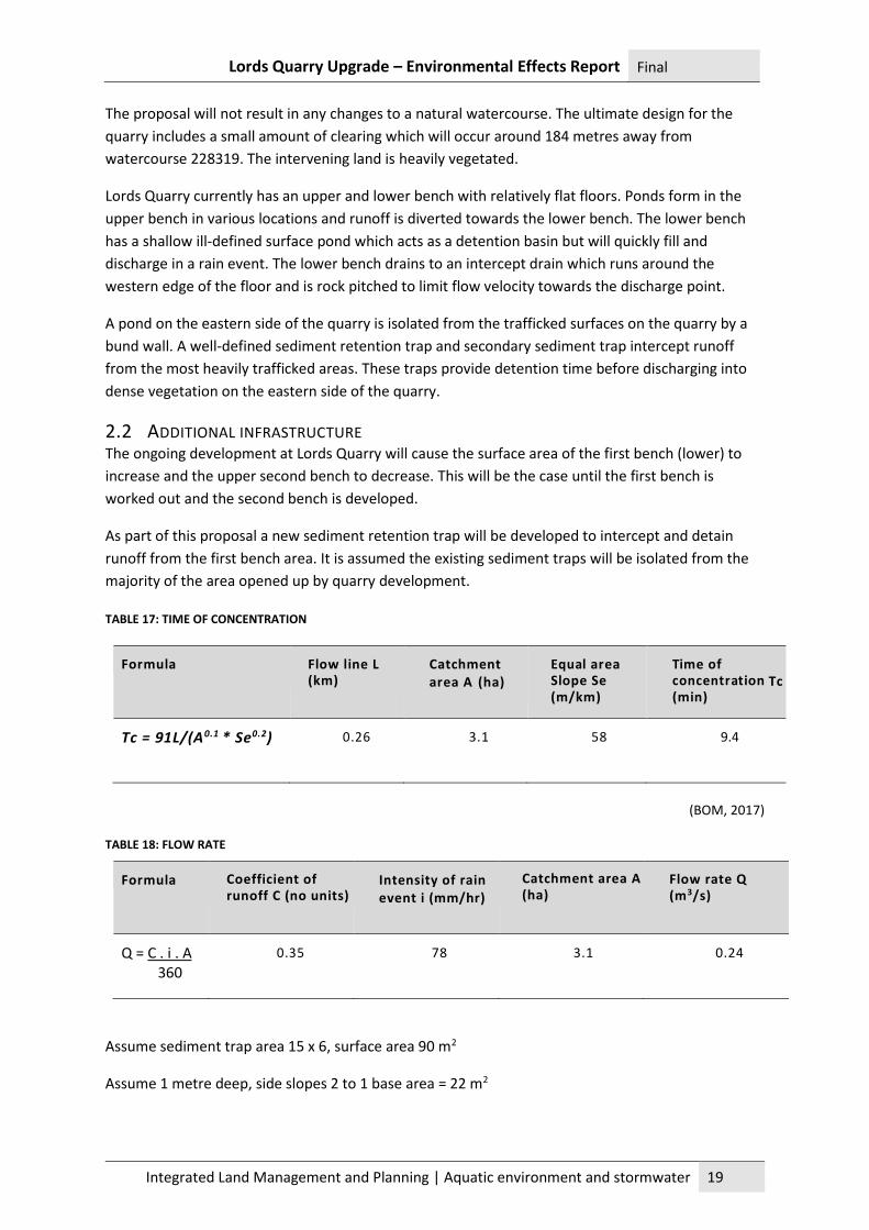
2.2 ADDITIONAL INFRASTRUCTURE The ongoing development at Lords Quarry will cause the surface area of the first bench (lower) to
increase and the upper second bench to decrease. This will be the case until the first bench is
worked out and the second bench is developed.
As part of this proposal a new sediment retention trap will be developed to intercept and detain
runoff from the first bench area. It is assumed the existing sediment traps will be isolated from the
majority of the area opened up by quarry development.
TABLE 17: TIME OF CONCENTRATION
Formula
Flow line L (km)
Catchment area A (ha)
Equal area Slope Se (m/km)
Time of concentration Tc (min)
Tc = 91L/(A 0.1 * Se0 . 2 )
0.26
3.1
58
9.4
(BOM, 2017)
TABLE 18: FLOW RATE
Formula
Coefficient of runoff C (no units)
Intensity of rain event i (mm/hr)
Catchment area A (ha)
Flow rate Q (m3/s)
Q = C . i . A 360
0.35
78
3.1
0.24
Assume sediment trap area 15 x 6, surface area 90 m2
Assume 1 metre deep, side slopes 2 to 1 base area = 22 m2
Lords Quarry Upgrade – Environmental Effects Report Final
Integrated Land Management and Planning | Significant areas 20
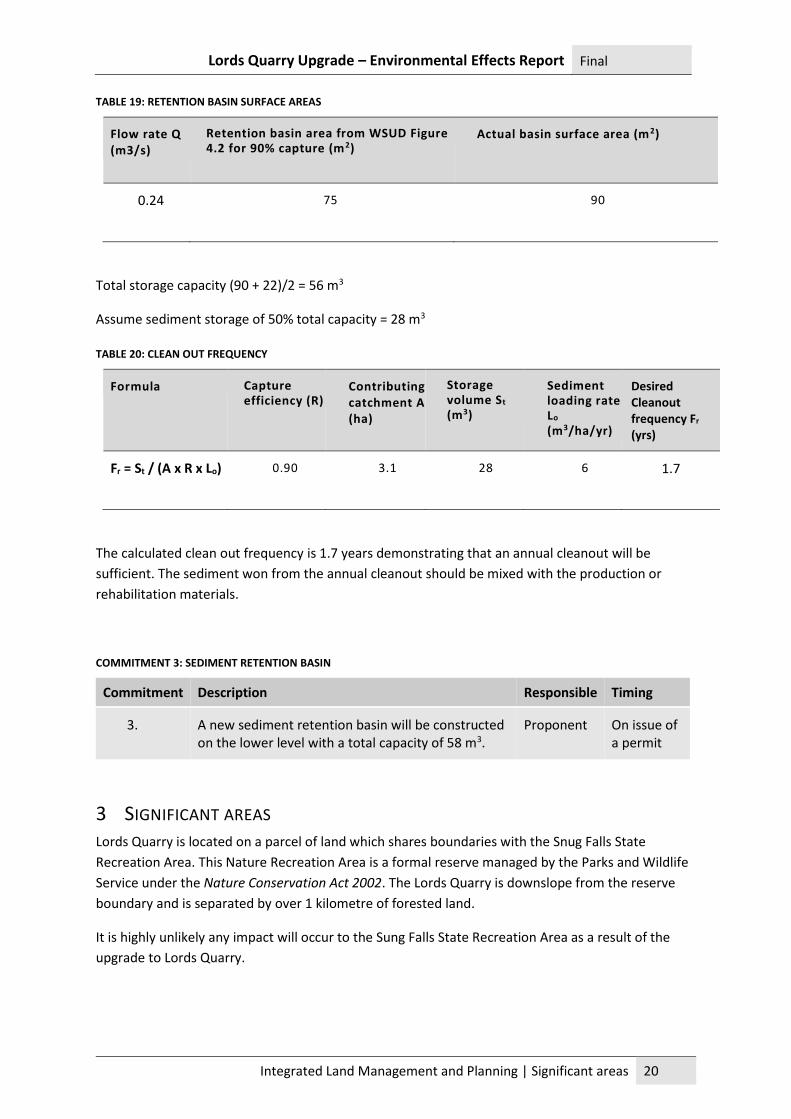
TABLE 19: RETENTION BASIN SURFACE AREAS
Flow rate Q (m3/s)
Retention basin area from WSUD Figure 4.2 for 90% capture (m2)
Actual basin surface area (m2)
0.24
75
90
Total storage capacity (90 + 22)/2 = 56 m3
Assume sediment storage of 50% total capacity = 28 m3
TABLE 20: CLEAN OUT FREQUENCY
Formula
Capture efficiency (R)
Contributing catchment A (ha)
Storage volume St
(m3)
Sediment loading rate Lo (m3/ha/yr)
Desired Cleanout frequency Fr (yrs)
Fr = St / (A x R x Lo)
0.90
3.1
28
6 1.7
The calculated clean out frequency is 1.7 years demonstrating that an annual cleanout will be
sufficient. The sediment won from the annual cleanout should be mixed with the production or
rehabilitation materials.
COMMITMENT 3: SEDIMENT RETENTION BASIN
Commitment Description Responsible Timing
3. A new sediment retention basin will be constructed on the lower level with a total capacity of 58 m3.
Proponent On issue of a permit
3 SIGNIFICANT AREAS Lords Quarry is located on a parcel of land which shares boundaries with the Snug Falls State
Recreation Area. This Nature Recreation Area is a formal reserve managed by the Parks and Wildlife
Service under the Nature Conservation Act 2002. The Lords Quarry is downslope from the reserve
boundary and is separated by over 1 kilometre of forested land.
It is highly unlikely any impact will occur to the Sung Falls State Recreation Area as a result of the
upgrade to Lords Quarry.
Lords Quarry Upgrade – Environmental Effects Report Final
Integrated Land Management and Planning | Air emissions 21
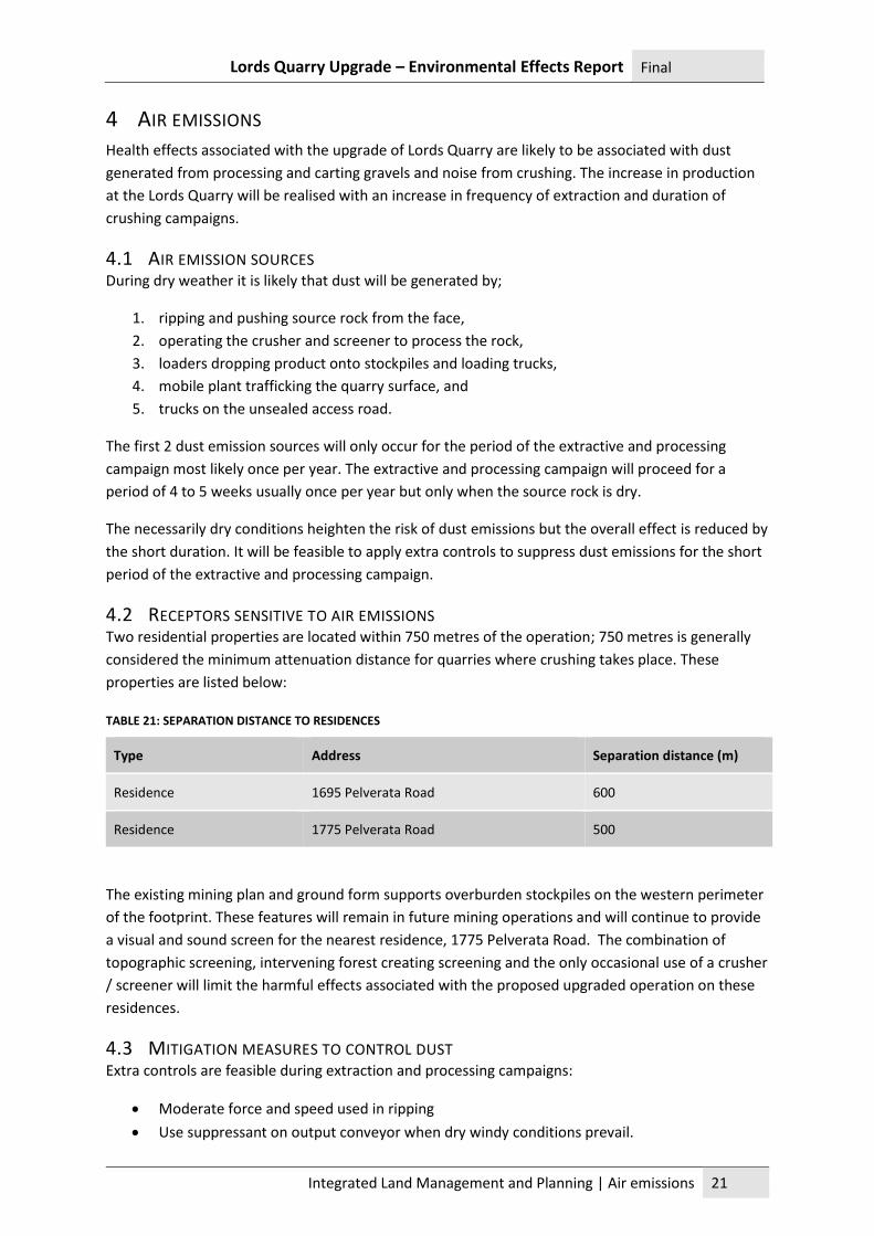
4 AIR EMISSIONS Health effects associated with the upgrade of Lords Quarry are likely to be associated with dust
generated from processing and carting gravels and noise from crushing. The increase in production
at the Lords Quarry will be realised with an increase in frequency of extraction and duration of
crushing campaigns.
4.1 AIR EMISSION SOURCES During dry weather it is likely that dust will be generated by;
1. ripping and pushing source rock from the face,
2. operating the crusher and screener to process the rock,
3. loaders dropping product onto stockpiles and loading trucks,
4. mobile plant trafficking the quarry surface, and
5. trucks on the unsealed access road.
The first 2 dust emission sources will only occur for the period of the extractive and processing
campaign most likely once per year. The extractive and processing campaign will proceed for a
period of 4 to 5 weeks usually once per year but only when the source rock is dry.
The necessarily dry conditions heighten the risk of dust emissions but the overall effect is reduced by
the short duration. It will be feasible to apply extra controls to suppress dust emissions for the short
period of the extractive and processing campaign.
4.2 RECEPTORS SENSITIVE TO AIR EMISSIONS Two residential properties are located within 750 metres of the operation; 750 metres is generally
considered the minimum attenuation distance for quarries where crushing takes place. These
properties are listed below:
TABLE 21: SEPARATION DISTANCE TO RESIDENCES
Type Address Separation distance (m)
Residence 1695 Pelverata Road 600
Residence 1775 Pelverata Road 500
The existing mining plan and ground form supports overburden stockpiles on the western perimeter
of the footprint. These features will remain in future mining operations and will continue to provide
a visual and sound screen for the nearest residence, 1775 Pelverata Road. The combination of
topographic screening, intervening forest creating screening and the only occasional use of a crusher
/ screener will limit the harmful effects associated with the proposed upgraded operation on these
residences.
4.3 MITIGATION MEASURES TO CONTROL DUST Extra controls are feasible during extraction and processing campaigns:
• Moderate force and speed used in ripping
• Use suppressant on output conveyor when dry windy conditions prevail.
Lords Quarry Upgrade – Environmental Effects Report Final
Integrated Land Management and Planning | Liquid effluent 22
• Keep drop distance low when loading to stockpiles.
During normal operations the following measures may be applied when conditions demand:
• Keep mobile plant travel speed slow in the quarry site.
• Vehicle speeds kept slow within the perimeter of the quarry area.
• Drop distances small when loading trucks.
• Keep load below the height of the sides of the tray when loading trucks.
• Vehicle speeds on access road kept slow by steep incline.
COMMITMENT 4: DUST SUPPRESSION CONTROLS
Commitment Description Responsible Timing
4. Use control measures appropriate for the conditions to prevent dust causing a nuisance to neighbours.
Proponent On issue of a permit
5 LIQUID EFFLUENT During extractive and processing campaigns when Lords Quarry has workers on site every day, ‘Port
a Loo’ type amenities will be transported to the site for the use of the personnel. No permanent
facilities will be established on the site and facilities will not be provided for the use of occasional
visitors to the quarry. At the completion of an extractive and processing campaign the relocatable
toilet will be emptied at a designated black water dump point and returned to the hire company.
It is envisaged if dust suppression is required fine mist sprays of water will be applied and no other
chemicals.
The mobile plant will be energised with diesel engines which will be refueled using a utility mounted
refueling facility. A proprietary hydrocarbon spill kit will be available for immediate deployment
during refueling operations.
COMMITMENT 5: HYDROCARBON SPILL CONTROL
Commitment Description Responsible Timing
5. A proprietary hydrocarbon spill kit will be available for immediate deployment during refueling operations.
Proponent On issue of a permit
6 SOLID WASTE
The equipment used at Lords Quarry for each productive campaign will be serviced prior to delivery and will not require servicing until after demobilisation.
Litter associated will lubricating equipment, minor spares and food scraps will be collected in the machine operator’s utes and taken to a disposal facility at the end of each day.
Lords Quarry Upgrade – Environmental Effects Report Final
Integrated Land Management and Planning | Noise emissions 23
COMMITMENT 6: SOLID WASTE DISPOSAL
Commitment Description Responsible Timing
6. Waste including food waste, lubricating tubes and other spares and packaging will be collected in the machine operator’s ute and disposed of off-site at an approved disposal facility.
Proponent On issue of a permit
7 NOISE EMISSIONS The Proponent contracted Noise Vibration Consulting to conduct a noise assessment considering the
proximity of residences, the type and occasional nature of activities.
The Quarry Code of Practice (QCoP) sets out acceptable noise levels when measured at sensitive
receptors for various time of the day.
TABLE 22: MAXIMUM ACCEPTABLE NOISE LEVELS
Time of day Hours Acceptable noise level (dBA)
Day time 0700 to 1900 45
Evening 1900 to 2200 40
Night time 2200 to 0700 35
(Environment Protection Authority, May 2017)
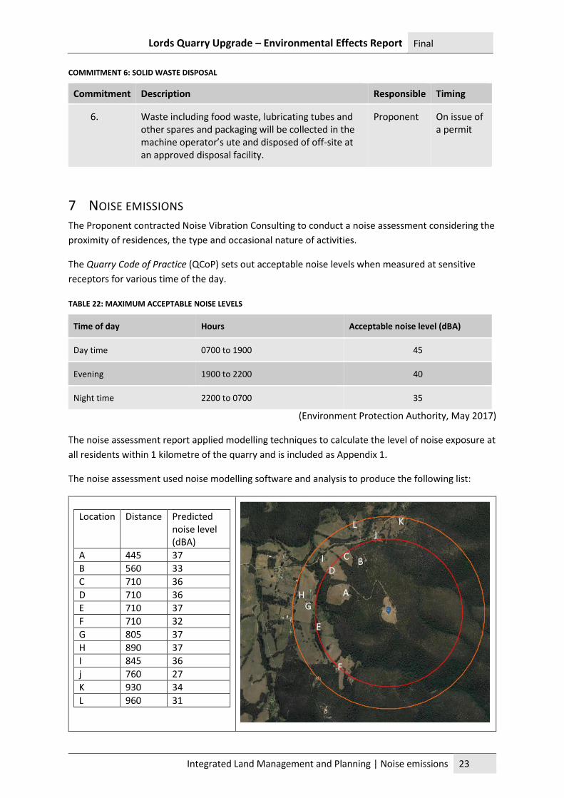
The noise assessment report applied modelling techniques to calculate the level of noise exposure at
all residents within 1 kilometre of the quarry and is included as Appendix 1.
The noise assessment used noise modelling software and analysis to produce the following list:
Location Distance Predicted noise level (dBA)
A 445 37
B 560 33
C 710 36
D 710 36
E 710 37
F 710 32
G 805 37
H 890 37
I 845 36
j 760 27
K 930 34
L 960 31
A
B D
L K
J
I
H G
F
E
C
Lords Quarry Upgrade – Environmental Effects Report Final
Integrated Land Management and Planning | Transport impacts 24
Lords Quarry will operate between the hours of 7.00 am and 7.00 pm, which is considered ‘daytime’
by the QCoP. The QCoP sets a maximum acceptable noise level at any premises of 45 dBA during this
period. The predicted noise levels determined as a result of modelling in the noise assessment are all
well below the accepted maximum.
The report recommended that the existing bund to the west be maintained to retain screening in
this direction. The mining plan shows there is no plan to disturb this bund until the quarry is
decommissioned (Noise, Vibration Consulting, Jan 2018).
COMMITMENT 7: NOISE
Commitment Description Responsible Timing
7. The overburden bund on the western perimeter of the quarry will be maintained for the life of the operation.
Proponent At all times
8 TRANSPORT IMPACTS Cartage from the Lords Quarry will be provided either by the Proponent, by a client or by sub-
contractors. Cartage will be mostly provided by medium combination trucks with a conservative
payload of 32 tonnes.
TABLE 23: TRAFFIC MOVEMENTS
Maximum production (m3) / (t)
Truck payload (t)
Annual production Operating weeks
Movements per week
Movements per day
Truck loads Movements
20 000 /
32 000
32 1 000 2 000 44 45 8
The machinery operator attending the site will account for 2 light vehicle movements, hence a total
on average of 10 movements per day is likely. The traffic from the quarry will vary according to how
contracts are serviced and there may be occasions when up to 30 movements per day will occur for
a short duration.
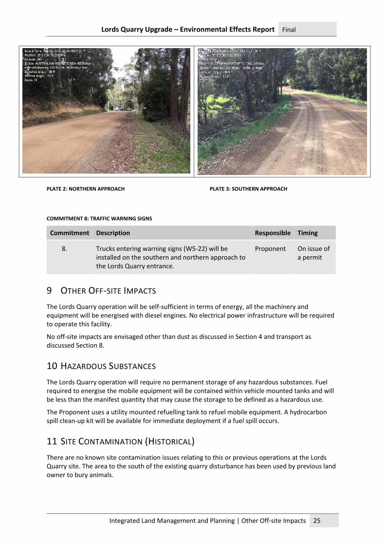
The quarry access originates at a junction with Pelverata Road. Pelverata Road is gravel construction
with tight radius curves and steep inclines in places. The access junction is located north of a tight
radius bend over a pipe culvert.
Although vehicle speeds are low on Pelverata Road the quarry access is less visible due to
encroaching vegetation on both approaches. To ensure that road users are aware that heavy
vehicles may be entering onto Pelverata Road at this location, warning signs will be erected on the
approach from north and south.
Lords Quarry Upgrade – Environmental Effects Report Final
Integrated Land Management and Planning | Other Off-site Impacts 25
PLATE 2: NORTHERN APPROACH PLATE 3: SOUTHERN APPROACH
COMMITMENT 8: TRAFFIC WARNING SIGNS
Commitment Description Responsible Timing
8. Trucks entering warning signs (W5-22) will be installed on the southern and northern approach to the Lords Quarry entrance.
Proponent On issue of a permit
9 OTHER OFF-SITE IMPACTS
The Lords Quarry operation will be self-sufficient in terms of energy, all the machinery and equipment will be energised with diesel engines. No electrical power infrastructure will be required to operate this facility.
No off-site impacts are envisaged other than dust as discussed in Section 4 and transport as discussed Section 8.
10 HAZARDOUS SUBSTANCES
The Lords Quarry operation will require no permanent storage of any hazardous substances. Fuel required to energise the mobile equipment will be contained within vehicle mounted tanks and will be less than the manifest quantity that may cause the storage to be defined as a hazardous use.
The Proponent uses a utility mounted refuelling tank to refuel mobile equipment. A hydrocarbon spill clean-up kit will be available for immediate deployment if a fuel spill occurs.
11 SITE CONTAMINATION (HISTORICAL)
There are no known site contamination issues relating to this or previous operations at the Lords Quarry site. The area to the south of the existing quarry disturbance has been used by previous land owner to bury animals.
Lords Quarry Upgrade – Environmental Effects Report Final
Integrated Land Management and Planning | Climate Change 26
12 CLIMATE CHANGE
Lords Quarry site is not vulnerable to risks associated with climate change apart from the likely increase in the incidence and severity of bushfires. There is no permanent infrastructure at risk on the quarry site apart from the mobile crushing equipment. In the event the site is threatened by a bushfire the response will be early evacuation of all personnel to a safe place.
13 HERITAGE
13.1 HISTORIC HERITAGE The two heritage places listed under the Tasmanian Heritage Register as being on Pelverata Road are
located at 1305 and 609, neither of which is close to Lords Quarry (Tasmanian Heritage Register,
2017). It is highly unlikely the quarry development will have any impact on historic heritage.
13.2 ABORIGINAL HERITAGE The Lords Quarry site was significantly disturbed when the quarry was first established. Further
disturbance will be confined to the small (0.9 hectare) area immediately south of the existing quarry.
This area has been used by the previous land owner as a site to bury dead animals and is highly
disturbed and degraded.
COMMITMENT 9: ABORIGINAL HERITAGE
Commitment Description Responsible Timing
9. If suspected Aboriginal heritage sites or items are unearthed, an Unanticipated Discovery Plan will be put into immediate effect.
Proponent At all times
14 SITES OF HIGH PUBLIC INTEREST As stated in Section 3, the parcel of land holding the quarry shares boundaries with the Snug Falls
State Recreation Area. The actual quarry is separated from the reserve by over a kilometre of native
woodland. The quarry faces are orientated away from the reserve and the higher ground between
the quarry and the reserve is well forested. It is unlikely that the quarry would be visible from
vantage points on tracks within the Snug Falls State Recreation Area.
15 MONITORING
The Proponent will monitor the following parameters during operational phases of the Lords Quarry operation:
15.1 AIR EMISSIONS
If dust is observed to be creating a nuisance, the Proponent will use dust suppression techniques until such time as the adverse weather conditions subside.
15.2 SEDIMENT TRAP
The sediment traps will be monitored to ensure the total capacity of the impoundments are not reduced by more than half. If accumulated sediment is excessive, the traps will be cleared out and the spoil set aside with overburden to be used in future rehabilitation works.
Lords Quarry Upgrade – Environmental Effects Report Final
Integrated Land Management and Planning | Rehabilitation 27
16 REHABILITATION
16.1 OBJECTIVE
Rehabilitation works on Lords Quarry will seek to restore the site to a regenerated native forest, woodlands and grasslands community similar to that surrounding it.
16.2 PROGRESSIVE REHABILITATION
Lords Quarry occupies a small footprint for the mining lease area. The existing quarry footprint is constrained for the purposes of vehicle manoeuvring, materials stockpiles access to processing equipment and truck loading. Future expansion of the quarry will consist of developing a single bench above the existing. There will be little opportunity to rehabilitate areas until such time as extractive operations cease.
16.3 DECOMMISSIONING AND REHABILITATION
The Lords Quarry has a substantial productive life based on the reserves observed in the existing faces. If the operation becomes uneconomic or there is no longer a market for the material the Proponent will close and decommission the quarry. Decommissioning and rehabilitation will entail the following steps.
• All equipment will be demobilised and any gravel surfaces will be ripped to facilitate infiltration.
• The faces will be made stable and benches will be made impassable. This will be achieved by spreading overburden against faces and site won topsoil over benches and allowing natural recruitment for the surrounding pasture grasses to colonise the new surfaces.
• The sediment traps will remain in place but be cleaned out and the silt won will be lost in the rehabilitation works. The sediment traps will continue to provide detention to runoff during the revegetation phase until the traps are full of sediment, at which time disturbed surfaces will be stabilised with a cover of natural recruitment vegetation.
During the revegetation phase the Proponent will deploy weed treatment contractors to ensure any colonising weeds are controlled until reasonable ground cover with native species is achieved.
To prevent further disturbance the gate over the access road will be maintained and secured to exclude vehicles.
Lords Quarry Upgrade – Environmental Effects Report Final
Integrated Land Management and Planning | Part D Management commitments 28
PART D MANAGEMENT COMMITMENTS
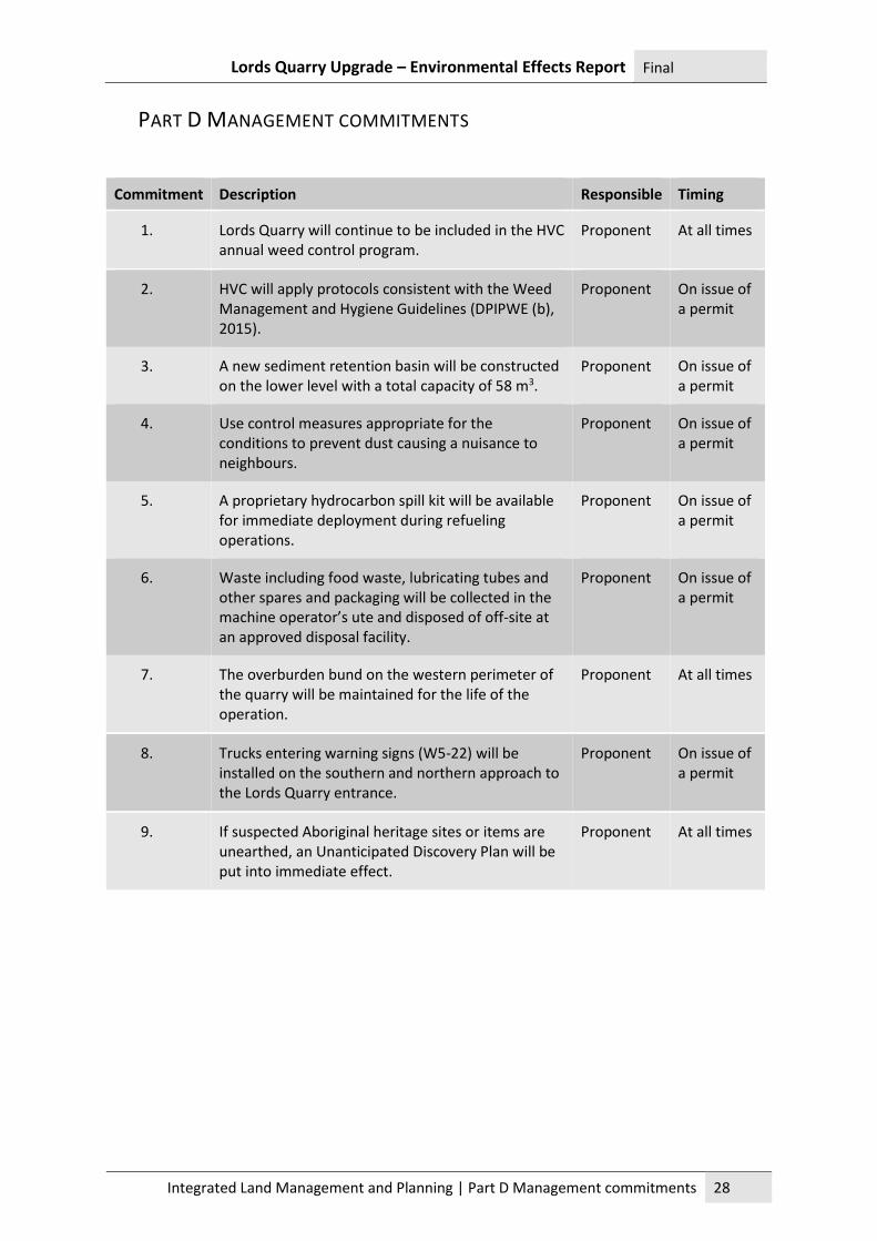
Commitment Description Responsible Timing
1. Lords Quarry will continue to be included in the HVC annual weed control program.
Proponent At all times
2. HVC will apply protocols consistent with the Weed Management and Hygiene Guidelines (DPIPWE (b), 2015).
Proponent On issue of a permit
3. A new sediment retention basin will be constructed on the lower level with a total capacity of 58 m3.
Proponent On issue of a permit
4. Use control measures appropriate for the conditions to prevent dust causing a nuisance to neighbours.
Proponent On issue of a permit
5. A proprietary hydrocarbon spill kit will be available for immediate deployment during refueling operations.
Proponent On issue of a permit
6. Waste including food waste, lubricating tubes and other spares and packaging will be collected in the machine operator’s ute and disposed of off-site at an approved disposal facility.
Proponent On issue of a permit
7. The overburden bund on the western perimeter of the quarry will be maintained for the life of the operation.
Proponent At all times
8. Trucks entering warning signs (W5-22) will be installed on the southern and northern approach to the Lords Quarry entrance.
Proponent On issue of a permit
9. If suspected Aboriginal heritage sites or items are unearthed, an Unanticipated Discovery Plan will be put into immediate effect.
Proponent At all times
Lords Quarry Upgrade – Environmental Effects Report Final
Integrated Land Management and Planning | Part E – Public and Stakeholder Consultation
29
PART E – PUBLIC AND STAKEHOLDER CONSULTATION The application to upgrade Lords Quarry is considered an ‘intensification’ of the existing ‘permitted’
use under Section 25 (1A) (b) of the Environmental Management and Pollution Control Act 1994. The
legislation requires that the application is dealt with in accordance with Section 57 of the Land Use
Planning and Approvals Act 1993 (EMPCA). This section requires that the application is treated as
discretionary and hence the planning authority must advertise the application and call for
representations. As the proposed activity is classified as a Level 2 under EMPCA the application must
be directed to the Board of the Environment Protection Authority for consideration.
Stakeholders that have been consulted through this process include the following:
• Huon Valley Council has been consulted regarding the status of the existing permit and
consideration of a new Development Application.
• The Board of the Environment Protection Authority (EPA) has been consulted prior to
submission of the Notice of Intent.
• The process of upgrading Lords Quarry has been discussed with Mineral Resources
Tasmania.
During the subsequent application assessment process these additional stakeholders will be
consulted:
• HVC acting as the Planning Authority with regard to traffic impacts on Pelverata Road.
• Policy and Conservation Advice Branch of DPIPWE with regard to land clearing required for
the future quarry expansion.
• Any property owners that share a boundary with the development site through a direct
notice from the Planning Authority.
• Aboriginal Heritage Tasmania to consider the heritage significance of the site.
Lords Quarry Upgrade – Environmental Effects Report Final
Integrated Land Management and Planning | References 30
17 REFERENCES BOM. (2017, Decemeber 20). 2016 Rainfall IFD Data System. Retrieved from Bureau of Meteorology:
http://www.bom.gov.au/water/designRainfalls/revised-
ifd/?coordinate_type=enz&easting=506897&northing=5230264&zone=55&sdmin=true&sdh
r=true&sdday=true&user_label=Lords+Quarry&year=2016
BOM. (2017, December 2017). Climate Statistics for Australian locations. Retrieved from Bureau of
Meteorology: http://www.bom.gov.au/climate/averages/tables/cw_094137.shtml
DPIPWE (b). (2015). Weed and Disease Planning and Hygiene Guidelines - Preventing the spread of
Weeds and Disease in Tasmania. Hobart: DPIPWE.
Environment Protection Authority. (May 2017). Quarry Code of Practice 3rd Edition. Hobart: EPA.
HVC. (2015). Huon Valley Interim Planning Scheme 2015. Hobart: Tasmanian Planning Commission.
Noise, Vibration Consulting. (Jan 2018). Lords Quarry - Noise Assessment. Hobart: unpublished.
Tasmanian Heritage Register. (2017, April 24). Heritage Listed Places. Retrieved from Heritage
Tasmania: http://heritage.tas.gov.au/heritage-listed-places/search-the-register
Lords Quarry Upgrade – Environmental Effects Report Final
Integrated Land Management and Planning | Appendix 1 -Lords Quarry – Noise Assessment, Noise Vibration Consulting
31
APPENDIX 1 -LORDS QUARRY – NOISE ASSESSMENT, NOISE VIBRATION
CONSULTING
CW Butler, trading as NVC A.B.N. 55 452 696 986 PO Box 476, Rosny Park, TAS 7018 t. 6244 5556 [email protected]
Huon Valley Council 22 December 2017 40 Main Street Huonville Tasmania 7109 5636.docx Attention: Malcolm Russell
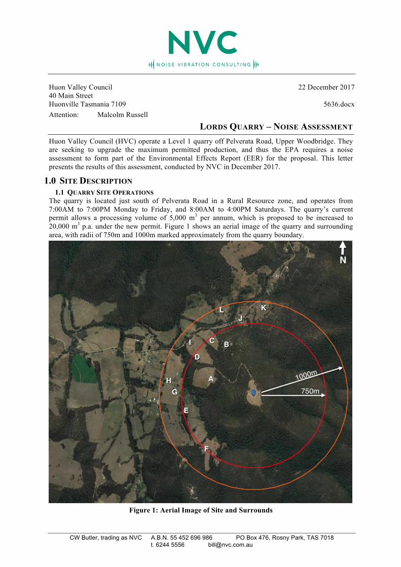
LORDS QUARRY – NOISE ASSESSMENT Huon Valley Council (HVC) operate a Level 1 quarry off Pelverata Road, Upper Woodbridge. They are seeking to upgrade the maximum permitted production, and thus the EPA requires a noise assessment to form part of the Environmental Effects Report (EER) for the proposal. This letter presents the results of this assessment, conducted by NVC in December 2017.
1.0 SITE DESCRIPTION 1.1 QUARRY SITE OPERATIONS The quarry is located just south of Pelverata Road in a Rural Resource zone, and operates from 7:00AM to 7:00PM Monday to Friday, and 8:00AM to 4:00PM Saturdays. The quarry’s current permit allows a processing volume of 5,000 m3 per annum, which is proposed to be increased to 20,000 m3 p.a. under the new permit. Figure 1 shows an aerial image of the quarry and surrounding area, with radii of 750m and 1000m marked approximately from the quarry boundary.
Figure 1: Aerial Image of Site and Surrounds
N
1000m
750m A
E
F
D B C
L J
K
G
I
H
LORDS QUARRY – NOISE ASSESSMENT
< 5636.docx Page 2
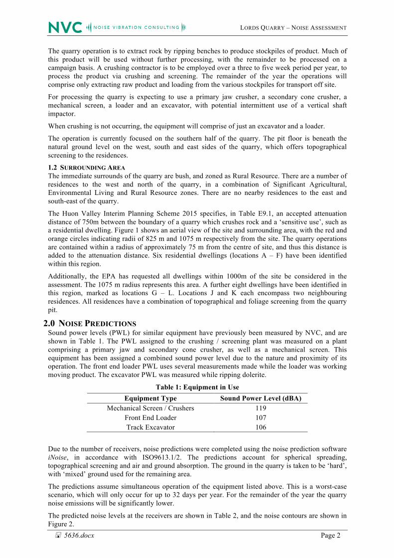
The quarry operation is to extract rock by ripping benches to produce stockpiles of product. Much of this product will be used without further processing, with the remainder to be processed on a campaign basis. A crushing contractor is to be employed over a three to five week period per year, to process the product via crushing and screening. The remainder of the year the operations will comprise only extracting raw product and loading from the various stockpiles for transport off site.
For processing the quarry is expecting to use a primary jaw crusher, a secondary cone crusher, a mechanical screen, a loader and an excavator, with potential intermittent use of a vertical shaft impactor.
When crushing is not occurring, the equipment will comprise of just an excavator and a loader.
The operation is currently focused on the southern half of the quarry. The pit floor is beneath the natural ground level on the west, south and east sides of the quarry, which offers topographical screening to the residences.
1.2 SURROUNDING AREA The immediate surrounds of the quarry are bush, and zoned as Rural Resource. There are a number of residences to the west and north of the quarry, in a combination of Significant Agricultural, Environmental Living and Rural Resource zones. There are no nearby residences to the east and south-east of the quarry.
The Huon Valley Interim Planning Scheme 2015 specifies, in Table E9.1, an accepted attenuation distance of 750m between the boundary of a quarry which crushes rock and a ‘sensitive use’, such as a residential dwelling. Figure 1 shows an aerial view of the site and surrounding area, with the red and orange circles indicating radii of 825 m and 1075 m respectively from the site. The quarry operations are contained within a radius of approximately 75 m from the centre of site, and thus this distance is added to the attenuation distance. Six residential dwellings (locations A – F) have been identified within this region.
Additionally, the EPA has requested all dwellings within 1000m of the site be considered in the assessment. The 1075 m radius represents this area. A further eight dwellings have been identified in this region, marked as locations G – L. Locations J and K each encompass two neighbouring residences. All residences have a combination of topographical and foliage screening from the quarry pit.
2.0 NOISE PREDICTIONS Sound power levels (PWL) for similar equipment have previously been measured by NVC, and are shown in Table 1. The PWL assigned to the crushing / screening plant was measured on a plant comprising a primary jaw and secondary cone crusher, as well as a mechanical screen. This equipment has been assigned a combined sound power level due to the nature and proximity of its operation. The front end loader PWL uses several measurements made while the loader was working moving product. The excavator PWL was measured while ripping dolerite.
Table 1: Equipment in Use Equipment Type Sound Power Level (dBA)
Mechanical Screen / Crushers 119 Front End Loader 107 Track Excavator 106
Due to the number of receivers, noise predictions were completed using the noise prediction software iNoise, in accordance with ISO9613.1/2. The predictions account for spherical spreading, topographical screening and air and ground absorption. The ground in the quarry is taken to be ‘hard’, with ‘mixed’ ground used for the remaining area.
The predictions assume simultaneous operation of the equipment listed above. This is a worst-case scenario, which will only occur for up to 32 days per year. For the remainder of the year the quarry noise emissions will be significantly lower.
The predicted noise levels at the receivers are shown in Table 2, and the noise contours are shown in Figure 2.
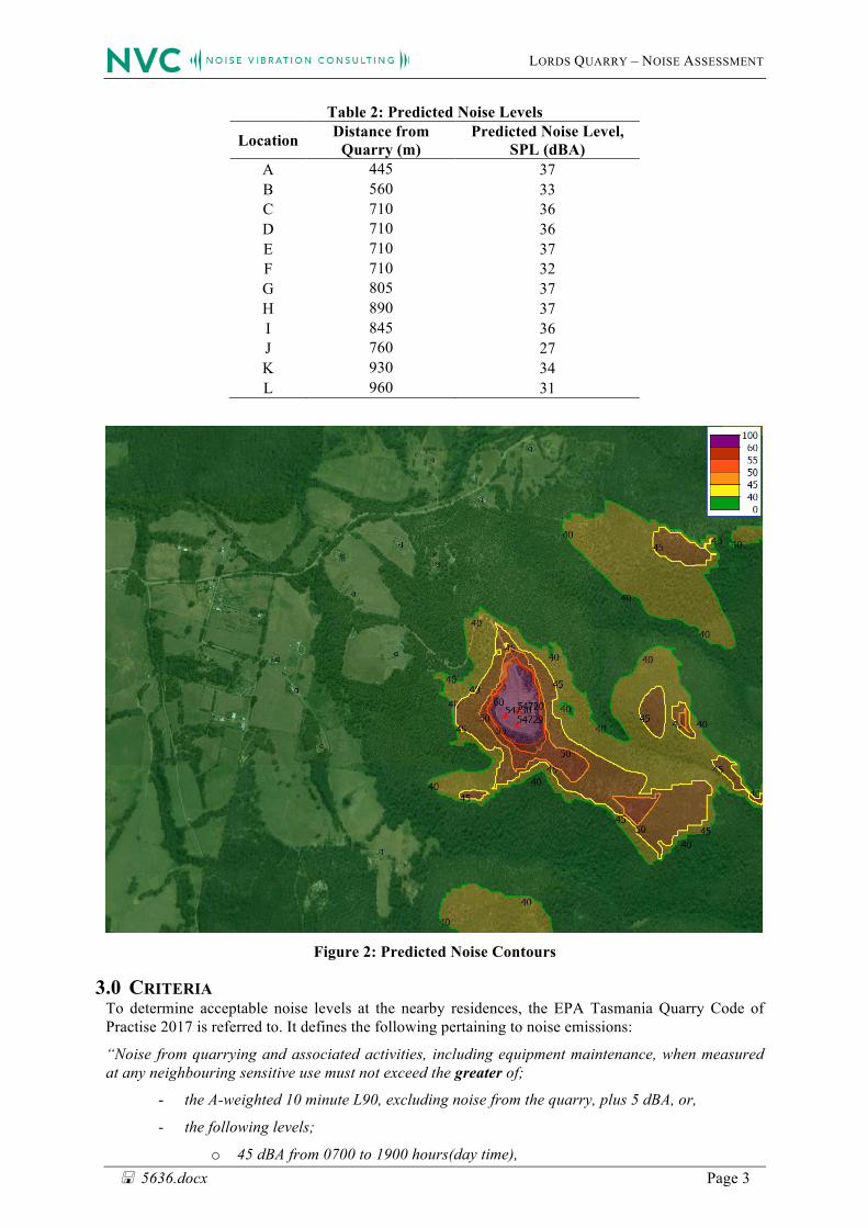
LORDS QUARRY – NOISE ASSESSMENT
< 5636.docx Page 3
Table 2: Predicted Noise Levels
Location Distance from Quarry (m)
Predicted Noise Level, SPL (dBA)
A 445 37 B 560 33 C 710 36 D 710 36 E 710 37 F 710 32 G 805 37 H 890 37 I 845 36 J 760 27 K 930 34 L 960 31
Figure 2: Predicted Noise Contours
3.0 CRITERIA To determine acceptable noise levels at the nearby residences, the EPA Tasmania Quarry Code of Practise 2017 is referred to. It defines the following pertaining to noise emissions:
“Noise from quarrying and associated activities, including equipment maintenance, when measured at any neighbouring sensitive use must not exceed the greater of;
- the A-weighted 10 minute L90, excluding noise from the quarry, plus 5 dBA, or,
- the following levels;
o 45 dBA from 0700 to 1900 hours(day time),
LORDS QUARRY – NOISE ASSESSMENT
< 5636.docx Page 4
o 40 dBA from 1900 to 2200 hours (evening),
o 35 dBA from 2200 to 0700 hours (night time). ”
Background noise levels near the quarry have not been measured, and as such the criterion during the day time is taken as 45 dBA. It should be noted that the measurement of background noise levels can only result in an increase of this criteria.
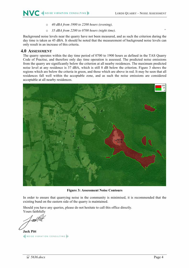
4.0 ASSESSMENT The quarry operates within the day time period of 0700 to 1900 hours as defined in the TAS Quarry Code of Practise, and therefore only day time operation is assessed. The predicted noise emissions from the quarry are significantly below the criterion at all nearby residences. The maximum predicted noise level at any residence is 37 dBA, which is still 8 dB below the criterion. Figure 3 shows the regions which are below the criteria in green, and those which are above in red. It may be seen that all residences fall well within the acceptable zone, and as such the noise emissions are considered acceptable at all nearby residences.
Figure 3: Assessment Noise Contours
In order to ensure that quarrying noise in the community is minimised, it is recommended that the existing bund on the eastern side of the quarry is maintained.
Should you have any queries, please do not hesitate to call this office directly. Yours faithfully
Jack Pitt