Embed Size (px)
Citation preview

DECEMBER 13, 2005
City of Peoria LOOP 303 SPECIFIC AREA PLAN
Final Project Report

Loop 303 Specific Area Plan: Project Report Page i
TABLE OF CONTENTS INTRODUCTION AND STUDY OVERVIEW ..............................................................................................................................................................................1
Regional Context and Study Area............................................................................................................................................................................1 Purpose of the Specific Area Plan.............................................................................................................................................................................2 Vision Statement ..........................................................................................................................................................................................................2 Planning Process ..........................................................................................................................................................................................................3 Proposed Loop 303 Freeway......................................................................................................................................................................................3 Relationship to other Plans .........................................................................................................................................................................................4 Multi-Jurisdictional Collaboration ..............................................................................................................................................................................4 Document Organization.............................................................................................................................................................................................4
1. LAND USE/ ECONOMIC DEVELOPMENT/ COMMUNITY DESIGN .....................................................................................................................................5 Setting ............................................................................................................................................................................................................................5 Key Issues.......................................................................................................................................................................................................................6
Community Identity.................................................................................................................................................................................................6 Employment and Land Use Balance....................................................................................................................................................................6 Commercial Development ....................................................................................................................................................................................6 Mixed-Use Developments/Neighborhoods .........................................................................................................................................................6 Resort/Hospitality Development............................................................................................................................................................................8 Preservation of Existing Natural Environment ......................................................................................................................................................8 Rivers, Canals, and Washes ...................................................................................................................................................................................8 Topography ..............................................................................................................................................................................................................8 Views and Viewsheds ............................................................................................................................................................................................9 Westwing Substation and Transmission Corridors................................................................................................................................................9
Goals and Policies .......................................................................................................................................................................................................9 Community Identity.................................................................................................................................................................................................9 Employment and Land Use Balance....................................................................................................................................................................9 Resort/Hospitality Development..........................................................................................................................................................................10 Land Use Compatibility.........................................................................................................................................................................................10 Residential Neighborhood Diversity and Design ..............................................................................................................................................11 Commercial Area Design.....................................................................................................................................................................................11 Industrial and Business Park Design .....................................................................................................................................................................12

Loop 303 Specific Area Plan: Project Report Page ii
Integrated Parks and Open Space ....................................................................................................................................................................12 Environmental Resources .....................................................................................................................................................................................12
Land Use Plan .............................................................................................................................................................................................................13 Summary .................................................................................................................................................................................................................13 Land Use Map and Designations ........................................................................................................................................................................22 Land Use Distribution .............................................................................................................................................................................................24
2. CIRCULATION......................................................................................................................................................................................................27 Setting ..........................................................................................................................................................................................................................27
Functional Classification.......................................................................................................................................................................................27 Key Issues.....................................................................................................................................................................................................................28
Roadway Network Planning ................................................................................................................................................................................28 Roadway Design....................................................................................................................................................................................................28 Transportation-Supportive Site Design................................................................................................................................................................28 Trail System..............................................................................................................................................................................................................28
Goals and Policies .....................................................................................................................................................................................................29 Roadway Network.................................................................................................................................................................................................29 Roadway Design....................................................................................................................................................................................................29 Transportation-Supportive Site Design................................................................................................................................................................30 Trail System..............................................................................................................................................................................................................30
Circulation Plan ..........................................................................................................................................................................................................30 3. PARKS, TRAILS, AND OPEN SPACE ..........................................................................................................................................................................31
Setting ..........................................................................................................................................................................................................................31 Key Issues.....................................................................................................................................................................................................................31
River Corridors and Adjacent Trail Connections...............................................................................................................................................31 Parks and Recreation............................................................................................................................................................................................32
Goals and Policies .....................................................................................................................................................................................................33 System Planning .....................................................................................................................................................................................................33 River Corridor Systems ...........................................................................................................................................................................................33 Trail Linkages...........................................................................................................................................................................................................34
4. PUBLIC FACILITIES AND SERVICES............................................................................................................................................................................35 BLM Property...........................................................................................................................................................................................................35

Loop 303 Specific Area Plan: Project Report Page iii
Municipal Operations Center ..............................................................................................................................................................................35 Public Safety ...........................................................................................................................................................................................................35
Goals and Policies .....................................................................................................................................................................................................36 Municipal Operations............................................................................................................................................................................................36 Education................................................................................................................................................................................................................36 Public Health and Safety......................................................................................................................................................................................36 Infrastructure Improvements ................................................................................................................................................................................37
LIST OF FIGURES Figure 1: Study Area Location ........................................................................................................................................................................................1 Figure 1-1: Land Use and Circulation Plan..................................................................................................................................................................26
LIST OF TABLES Table 1-1: Existing Land Use.............................................................................................................................................................................................5
Table 1-2: Land Ownership..............................................................................................................................................................................................5
Table 1-3: Existing General Plan Land Use Designations ............................................................................................................................................5
Table 1-4: Typical Characteristics of Commercial Centers........................................................................................................................................7
Table 1-5: Land Use Designations.................................................................................................................................................................................22
Table 1-6: Recommended Land Use Distribution ......................................................................................................................................................24
Table 2-1: SR 303 Interchange Location .....................................................................................................................................................................27
Loop 303 Specific Area Plan: Project Report Page iv

Loop 303 Specific Area Plan: Project Report Page 1
INTRODUCTION AND STUDY OVERVIEW The Loop 303 Corridor and the interchanges that will provide access to and from it represent an outstanding opportunity for the City of Peoria to enhance its standing as a regional employment base. More importantly, however, it provides an opportunity for the City to ensure that the residents of Peoria have more opportunities to live and work in the community. The Loop 303 Specific Area Plan is the vehicle for the City’s expression of its vision for the corridor specifically and for North Peoria generally.
REGIONAL CONTEXT AND STUDY AREA The City of Peoria is a rapidly growing community located in Maricopa County, approximately 10 miles northwest of downtown Phoenix. Between 1980 and 2005, Peoria experienced unparalleled growth as it blossomed from a small town of approximately 12,000 into a community of nearly 139,000. Rapid growth within the region over the past five years continues to accelerate the pace of the City’s development into its far northern and western regions. Since 2000, the City of Peoria has experienced a 20.4% rate of population growth, dramatically outpacing the regional growth rate of 3.3%. Similarly, Peoria witnessed a 13.0% increase in employment surpassing the regional rate of 4.1%. Projections show Peoria’s growth through 2030 will increase its population by 92% and employment by 340% over 2004 levels.
As development continues to expand into the peripheral areas of the region, the City of Peoria must be prepared to accommodate growth associated with new development, much of which will be spurred by new or enhanced transportation access. Notably, the Loop 303 is proposed as the transportation backbone for the northwestern region of the metropolitan area and will traverse Northern Peoria.
Consisting of approximately 20,800 acres or about 32.5 square miles, the Study Area addressed in the Loop 303 Specific Area
Plan includes a corridor bisected by the portion of the proposed Loop 303 extending north and east of the El Mirage Road/Loop 303 interchange, to north of the proposed New
Figure 1: Study Area Location

Loop 303 Specific Area Plan: Project Report Page 2
River Freeway (see Figure 1). The Study Area includes the land within one mile of the proposed freeway corridor, to allow consideration of the edge treatment and circulation/ infrastructure connectivity with the surrounding network.
PURPOSE OF THE SPECIFIC AREA PLAN This document provides a broad-based strategic planning tool that will not only assist in the implementation of the City’s General Plan, but will also communicate the City’s expectations to the regional and national development community regarding the appropriate type and quality of development in the Loop 303 Corridor. The City has prepared this document in compliance with state statutes (ARS §9-461.08) pertaining to the preparation of specific plans. The City will amend its existing General Plan (through the major amendment process) to incorporate the land uses and locations recommended in this specific plan for the Loop 303 corridor. The development of this plan has been accomplished with consideration of several major themes, including:
Employment Growth and Sales Tax Capture. The Plan should leverage the visibility and accessibility of the Loop 303 Corridor.
Vehicular and Pedestrian Connectivity. The Plan should minimize the divisive effects that a major transportation corridor could cause, including the further bifurcation of Peoria.
Land Use Compatibility. The Plan should promote compatibility of uses, both in terms of effects associated with the Loop 303 (i.e., light and noise) and compatibility between uses, both existing and future.
Environmental/Cultural Protection. The Plan should identify sensitive environmental and cultural resources and manage to protect those resources.
Housing Choices and Balance. The Plan should provide a range of housing options for a variety of income levels in a manner that promotes a convenient spatial relationship
between new housing opportunities and future employment, commercial, and recreational centers.
Cost Considerations. The Plan should facilitate fiscally balanced development and phased infrastructure/public facility improvements.
Consistent Quality Design. The Plan should foster high quality design that will contribute to Peoria’s overall quality of life.
VISION STATEMENT Peoria adopted and ratified its existing General Plan pursuant to Arizona Revised Statutes (ARS §9-461) in 2001 and has since amended the plan several times, with the most recent set of amendments occurring in 2004. Since its adoption, the General Plan has provided the guidance for elected and appointed City representatives and City staff to manage growth and achieve the City’s overall vision for the community. This City’s vision, as included in the General Plan, is as follows:
Peoria, Arizona is an outstanding place to live, work and play with superior recreational facilities, municipal services, and transportation accessibility to local and regional attractions. Peoria is an advantageous City for commerce and business with superior schools, outstanding residential neighborhoods, and a thriving economy. It is a big City, with small town friendliness and charm, attracting visitors, both near and far, for business, recreation and tourism.
This vision both sets the stage for future development and establishes a benchmark against which future plans and development can be measured. This includes the Loop 303 Specific Area Plan, which translates this vision into specific guidance for the future of development in the Loop 303 Corridor.

Loop 303 Specific Area Plan: Project Report Page 3
PLANNING PROCESS The process of developing the Loop 303 Corridor Specific Area Plan included the completion of the following primary tasks in 2005:
Inventory and Analysis. During this phase of the project, data on existing conditions were compiled using Geographic Information Systems (GIS). A Map Atlas is available under separate cover from the City of Peoria’s Community Development Department. Population and employment growth were forecast to understand the development potential of the area.
Specific Plan Land Use Alternatives. Alternatives for land use in Loop 303 Corridor were evaluated through a charette process to respond to the goals and vision for the area, the opportunities presented by the proposed Loop 303, and to address land use compatibility, employment growth potential and sale tax capture, and other issues described as part of the purpose of the Specific Area Plan (see above).
Throughout the planning process, input was solicited from a Technical Advisory Committee (composed of City Staff) and key stakeholders (through interviews and meetings). The plan was presented to and reviewed by the Economic Development Advisory Board and the Parks and Recreation Board for their guidance on matters concerning Economic Development and Open Space. Adjacent property owners were notified of the planning process and given copies of the proposed land uses and circulation. The land use map was also posted on the City’s web site. Public comment was invited throughout the public comment period and received from written comments, email comments, neighborhood meeting comments and was considered by the Planning and Zoning Commission and City Council and reflected, as appropriate, in the final Plan.
PROPOSED LOOP 303 FREEWAY Loop 303 (or the Estrella Freeway) is proposed by the Arizona Department of Transportation as a high-capacity roadway, ultimately with four general-purpose lanes and one high-occupancy vehicle lane for each direction of travel. The Loop 303 would complete a regional freeway system that links Interstate 17 with Interstate 10. Freeway construction is funded by the sales tax extension that was approved in 2004 by Maricopa County voters, and is currently in the design concept stage.
The freeway corridor addressed within the Plan includes the proposed Loop 303 and its interchanges, as well as a proposed freeway connection from Loop 303 to State Route 74. The extension will be known as the “New River Freeway” when it is extended to I-17. The New River Freeway will extend northward from the 303 just west of the New River, ultimately connecting with I-17 to create a bypass that will allow traffic to avoid congested areas of I-17 in North Phoenix. Service interchanges would occur in nine locations within the Study Area.
Loop 303 will be constructed in phases in accordance with the Regional Transportation Plan adopted by the Maricopa Association of Governments (MAG). The first phase is planned for completion in 2010. Within the Study Area, this phase would include the construction of two lanes in each direction; the service interchanges at Happy Valley Parkway, Lone Mountain/Dynamite Parkway, and Lake Pleasant Parkway; and the freeway connection between Loop 303 and the New River Freeway (contingent upon an update to the MAG Regional Transportation Plan).
During the second phase (2011-2015), the freeway would be expanded to six lanes and remaining service interchanges in the Study Area would be constructed. Subsequently, the freeway will be expanded in response to demand as the area develops, with the ultimate buildout of the freeway anticipated by 2030.

Loop 303 Specific Area Plan: Project Report Page 4
RELATIONSHIP TO OTHER PLANS Because of its strategic citywide and regional importance, the Study Area for this project has been the focus of several planning processes. This includes City-sponsored efforts such as the Desert Lands Conservation Master Plan, the North Peoria Drainage Master Plan, The North Peoria/Lake Pleasant Specific Plan, the Lake Pleasant Parkway Specific Area Plan, the ongoing Park/Open Space and Trails Plan, and the ongoing Lake Pleasant Parkway Design Theme Manual. In addition, several regional efforts have covered the Study Area, including MAG’s West Valley Multi-Modal Transportation Corridor Master Plan and FCDMC’s Agua Fria Watercourse Master Plan. All of these plans include assumptions about the character of development in North Peoria, and many assume that much of the Study Area will remain rural or semi-rural as it develops. Because this Plan articulates a vision and establishes plans for a broad mix of urban uses, many of the assumptions made through other planning efforts may have to be reconsidered and those plans may need to be updated to reflect the changing economic and development character of North Peoria generally and the Loop 303 Corridor specifically.
MULTI-JURISDICTIONAL COLLABORATION This Plan affects the interests of a wide variety of public agency stakeholders other than the City of Peoria, including the State Land Department, the Bureau of Reclamation, the City of Phoenix, and Maricopa County (through both Flood Control District jurisdiction and general County jurisdiction over currently unincorporated land). The nature of each jurisdiction’s interest in the area in some cases results in overlap and, in others, potential competition or conflict. This is particularly the case when it comes to respective efforts to develop and/or conserve areas from development. The City of Peoria has been and continues to be committed to ensuring effective multi-jurisdictional partnering to promote achievement of objectives that will benefit all stakeholders.
DOCUMENT ORGANIZATION The remainder of the Loop 303 Corridor Specific Area Plan consists of five chapters. This includes four chapters focusing on policy content,: Land Use/Urban Design/Economic Development; Circulation; Parks, Trails, and Open Space; and Public Facilities and Utilities. Each of these chapters is organized into the following sections:
Setting. Describes key aspects of the physical, demographic, and economic setting for each subject addressed in the plan.
Key Issues. Presents a concise summary of pertinent supportive information and the key issues of the topical area.
Goals, Policies, and Actions. Provides the guiding statements for each topical area, consistent with the format established in the Peoria General Plan.
Plan. The Land Use/Urban Design/Economic Development chapter also includes a section that describes the Land Use Plan in narrative terms, with an emphasis on the strategic intent of the designations depicted on the Plan map.
Loop 303 Specific Area Plan: Project Report Page 5
1. LAND USE/ ECONOMIC DEVELOPMENT/ COMMUNITY DESIGN
This element describes the location of existing and planned land uses within the Study Area, as well as the goals and policies that will guide land use decisions. It also addresses broad urban design and economic development considerations.
SETTING The Loop 303 Specific Area Plan Study Area encompasses approximately 18,300 acres within Peoria, Phoenix, and Maricopa County. Most of the corridor is currently undeveloped, with the existing character dominated by natural features including rolling terrain, natural desert, rivers and their associated floodplains, and various native flora and fauna. Existing development is predominantly located south of Lone Mountain Parkway.
Table 1-1: Existing Land Use Land Use Classification Acreage % of Total Rural Residential 1 -- Estate Residential 36 0.2 Large Lot Residential 1 -- Very Small Lot Residential 9 -- Specialty Commercial 8 -- Public Facilities 202 1.0 Special Events 79 0.4 Transportation 3 -- Airports 96 0.5 Open Space 2,765 13.3 Water 967 4.5 Agriculture 903 4.4 Vacant 15,730 75.7 Total 20,800± 100.0
Source: Maricopa Association of Governments, 2005.
Land within the Study Area consists of a mixture of public and private lands as shown in Table 1-2. A vast majority, 70 percent, of the area is held in the State Trust—and thus managed by the Arizona State Land Department (ASLD)—with smaller percentages being controlled by the Federal Bureau of Land Management (BLM) and the Federal Bureau of Reclamation (BOR). Approximately 24 percent is privately owned, much of which falls within the Vistancia master planned community.
Table 1-2: Land Ownership Owner Acreage % of Total Arizona State Land Department 14,490 69.6 Bureau of Reclamation 476 2.3 Maricopa County 717 3.4 Bureau of Land Management 263 1.3 Private land 4,854 23.4 Total 20,800± 100.0
Source: URS, 2005.
Peoria’s existing General Plan designates a variety of land use classification within the Loop 303 Study Area as shown in Table 1-3.
Table 1-3: Existing General Plan Land Use Designations Land Use Classification Acreage % of Total Estate Residential 1,817 8.7 Low Density Residential 4,333 20.8 Medium Density Residential 1,606 7.7 Medium High Density Residential 368 1.8 High Density Residential 778 3.7 Mixed Use 768 3.7 Community Commercial 1,005 4.8 Business Park/Industrial 2,625 12.6 Park/Open Space 5,011 24.1 Public/Quasi-Public 330 1.6 Water 2,170 10.5 Total 20,800 ± 100.0
Source: City of Peoria, Maricopa Association of Governments, 2005.

Loop 303 Specific Area Plan: Project Report Page 6
In addition, parts of two “growth areas,” as designated in the City’s General Plan, are located within the Study Area (the North Central Peoria/ Lake Pleasant Parkway Growth Area and Carefree Highway/Northeast Peoria Growth Area). These growth area designations, which respond to requirements within the State of Arizona’s Growing Smarter/Plus statutes, “are intended to discourage ‘sprawl’ by promoting new development into targeted areas that are amenable to creating viable and concentrated areas integrating open spaces, natural resources and accommodating a variety of land uses (commercial, office, residential, tourism, industrial), oriented to multi-modal (transit, pedestrian, bicycling etc.) activity.”
KEY ISSUES COMMUNITY IDENTITY North Peoria has the potential become a prime location for signature development within the region, and Loop 303 will provide the access and visibility necessary to help realize that potential. This access and visibility represents an opportunity for the City to reaffirm and reinforce its unique identity within the region. In addition, with any freeway project, there is risk of bifurcation that might separate or isolate one side of the freeway from the other. A seamless transition in urban design will create a unified community character emphasizing the city in its entirety.
EMPLOYMENT AND LAND USE BALANCE Currently, 85 percent of Peoria residents work outside the City. A future goal of the City is to retain at least 50 percent of the employment base within the City. The available property within the corridor provides an opportunity for the City to employ strategies focusing on large-scale employment/corporate campus development. The City also sees the Corridor as an ideal opportunity to host large institutional users such as
hospitals and colleges or universities. Such facilities could contribute to the attractiveness of the Corridor as an employment center, while also providing convenient educational and health care opportunities for Peoria residents.
COMMERCIAL DEVELOPMENT Within the Study Area, demand for commercial development will take a variety of forms, ranging from neighborhood-scale to regional-scale. Table 1-4 summarizes typical characteristics of different scales of commercial development. The Land Use Plan for 303 Corridor will need to accommodate this variety through a balance of designations, in terms of both type and spatial distribution. The Loop 303 interchanges with major arterials within the Study Area offer opportunities to maximize exposure for commercial/retail development, particularly development with regional significance. The opportunity is very strong in the central part of the 303 Corridor because of the spacing between this area and other existing or planned regional-scale commercial developments in the northwest Valley. Another consideration with respect to regional commercial development is the evolving market, which has resulted in a movement toward “lifestyle” centers and away from large enclosed malls. Such lifestyle centers replicate many of the features of traditional downtown main streets, with open-air design geared toward pedestrian activity and amenities such as fountains and benches. The most prominent example in the Valley is Kierland Commons. Because of the large tracts of vacant land and the small number of landowners, there are also excellent opportunities to plan for and develop other large-scale projects, including power centers.
MIXED-USE DEVELOPMENTS/NEIGHBORHOODS For the most part, Peoria has developed in a pattern that segregates or separates different types of development from one another. Use patterns follow City zoning and Land Use

Loop 303 Specific Area Plan: Project Report Page 7
Table 1-4: Typical Characteristics of Commercial Centers
Center Concept Square Feet* Typical Anchors
Neighborhood Convenience 30,000- 150,000
1 or more supermarkets
Community General merchandise, convenience
100,000- 350,000
2 or more discount department stores, drug, home improvement, large specialty/discount apparel stores
Regional General merchandise, fashion (mall, typically enclosed)
400,000- 800,000
2 or more full-line department stores, junior department stores, mass merchants, discount department stores, fashion apparel
Super-regional Similar to regional center but has more variety and assortment
800,000+ 3 or more full-line department stores, junior department stores, mass merchants, fashion apparel
Fashion/ specialty
Higher-end, fashion-oriented
80,000- 250,000
Fashion
Lifestyle Upscale specialty stores; dining and entertainment in outdoor setting
150,000- 500,000
Not usually anchored, but may include large-format bookstore, multiplex cinema, small department stores
Power Category-dominant anchors, few small tenants
250,000- 600,000
3 or more home-improvement stores, discount department stores, warehouse clubs, off-price stores
Theme/ festival
Leisure, tourist-oriented, retail and service
80,000- 250,000
Restaurants, entertainment
Outlet Manufacturers' outlet stores
50,000- 400,000
Outlets
* — Including anchors Source: International Council of Shopping Centers
policies of identifying zoning districts and use categories according to individual use characteristics, grouping similar uses in a single district or category. This segregation has resulted in increased reliance on automobiles to move from place to place in the community. It has also caused some socioeconomic segregation based on housing cost and density segregation (i.e., higher-density housing tends to accommodate lower-income residents, while single-family homes tend to attract higher-income residents). The result is that recently-developed neighborhoods in Peoria, particularly master-planned communities, have become associated with the socioeconomic characteristics of their residents (e.g., starter-home, move-up, luxury). While this phenomenon is fairly typical, it does reinforce perceived differences among residents based on their income status or their stage of economic maturity that might not be evident in mixed-use or mixed-income communities. Another result is attributable to the single purpose nature of the current zoning and use planning policies. Rigidity resulting from one dimensional policy statements does not induce generation of innovative solutions. Mixed Use planning may allow more flexibility and innovation in grouping supporting uses, such as retail and residential, retail and job center or retail, residential and job center. Mixed Use planning also allows flexibility in consideration of locations for resorts. There are two basic ways in which the mixture of uses can be accommodated through the development planning and approval process. The first is to emphasize “mixed uses” at the neighborhood level and the second is to promote such mixture at the project level.
Mixed-Use Neighborhoods: The integration of different types of development within neighborhoods is an effective approach to reducing automobile use, both in terms of the number of trips and the distance of trips. This "mixed-use" strategy, according to which non-residential development (e.g., neighborhood commercial, schools, parks, small offices) is integrated into residential neighborhoods, increases opportunities for residents to walk or ride bikes instead of
Loop 303 Specific Area Plan: Project Report Page 8
driving cars. Furthermore, in cases where automobile use is unavoidable, mixed-use neighborhoods allow for much shorter automobile trips. Research suggests that mixed-use strategies can reduce site-specific trips and vehicle miles traveled (VMT) by 20 to 50 percent.
Mixed-Use Projects: Mixed-use projects differ from mixed-use neighborhoods in terms of scale. At the project level, uses are combined (i.e., office and residential). Most older downtowns have some of this type of development, most often in multi-story buildings with commercial uses on the ground floor and residential units on upper floors. Mixed-use projects are typically located in higher density areas with a variety of services available nearby so that the residents of such projects are able to walk for many trips that might otherwise require an automobile. There are two basic variations in mixed-use projects, those that mix uses within a building (vertical) and those that mix uses on a development site (horizontal). With vertical mixed-use, a single structure combines two or more uses, with the ground floor occupied with retail, service, or office uses and above-ground floors used for residential or office use. With horizontal mixed-use, two or more adjacent structures on a single development site provide commercial or office uses in the buildings fronting a public street and residential or office uses in separate buildings away from the street. A variation on vertical mixed-use is for a single structure to commits the street-facing ground floor to commercial or office uses, with attached residential or office uses behind.
RESORT/HOSPITALITY DEVELOPMENT The high quality scenery and natural amenities of North Peoria set the stage for potential resort development. The City’s General Plan supports such development, including several objectives and policies concerning resorts. Hospitality uses are also highly encouraged with Regional Commercial and Business Park development.
PRESERVATION OF EXISTING NATURAL ENVIRONMENT Sensitive environmental conditions and existence of diverse habitat and cultural features add richness to the Study Area, as do variations in topography. The City should capitalize on these features by promoting compatible land uses, promoting trail development, and seeking opportunities for potential recreational activities. This will perpetuate the City’s commitment to balancing environmental preservation with economic development, and its recognition that this practice contributes to the cultural richness of the community, which in turn benefits real estate and property values.
RIVERS, CANALS, AND WASHES The Study Area’s rivers, canals, and washes contribute considerably to the character and quality of the Loop 303 Corridor. In addition to being valuable aesthetic amenities, they serve as key organizing elements. In particular, the 100-year floodplains along the Agua Fria and New Rivers and Twin Buttes, Caterpillar Tank, and Deadman Washes establish edges that help define and confine suitable development areas within the Study Area. The man-made CAP and Beardsley Canals also create edges and pathways through the Study Area.
TOPOGRAPHY The Study Area is characterized by broad areas of alluvial fans and terraces separated by desert foothills and drainage channels. The majority of the land in the Study Area lies on slopes of less than 10 percent. The Peoria Hillside Ordinance uses 10 percent as the minimum grade for regulatory guidelines used to protect the land and visual quality during development activities.
Loop 303 Specific Area Plan: Project Report Page 9
VIEWS AND VIEWSHEDS The presence of several major landforms outside of, yet visible from, the Study Area provide a progression of interesting views. Major landforms visible from within the Study Area include Twin Buttes, Calderwood Butte, Westwing Mountain, Saddleback Mountain, the White Tanks Mountains, the Bradshaw Mountains and the Estrella Mountains. The richness of the topography and vistas makes the area unique to the metropolitan area.
WESTWING SUBSTATION AND TRANSMISSION CORRIDORS The facilities of the Arizona Public Service (APS) Company have a profound presence in the Study Area. This includes the Westwing Electrical Substation in the southwestern portion of the Study Area. This 200-acre facility serves as a regional relay station for electric power as it spawns a number of 500 kV, 345 kV, 230 kV and 69 kV lines extending northward and eastward from the substation through the Study Area. Both the substation and its associated transmission corridors present significant issues concerning land use compatibility.
GOALS AND POLICIES COMMUNITY IDENTITY Goal 1.1 To enhance Peoria’s sense of identity both within
the city and throughout the region.
1.1.1 The City shall strive to enhance and protect high quality vistas from the Loop 303 to surrounding areas within Peoria.
1.1.2 The City shall identify and enhance its major gateways into Peoria via the 303 Corridor and promote establishment of well-designed gateway treatments at all interchanges within the Corridor. This could include unique signage, wall art, monumentation, landscaping, or pavement that relates to the character of the area that the interchange provides access to.
1.1.3 In reviewing and approving development proposals and in designing public improvements in the Corridor, the City shall require the establishment of physical and visual linkages that minimize the potential barrier effect of the Loop 303.
EMPLOYMENT AND LAND USE BALANCE Goal 1.2 To provide a balance of land uses that will promote
economic development at appropriate locations in the Loop 303 Corridor.
1.2.1 The City shall reinforce the role of the Loop 303 Corridor as a prime location for high quality employment opportunities.
1.2.2 The City will continue its efforts to recruit major employers to the Loop 303 Corridor, particularly those that support primary wage earner jobs.
1.2.3 The City will work with the real estate development community to identify and make available sites that are suitable for large-scale office campuses or business parks. In particular, the areas adjacent to the interchanges at 96th Avenue and Lake Pleasant Parkway hold considerable promise as locations for major employment uses.
1.2.4 The City shall promote opportunities for development of higher education facilities in the Corridor.
1.2.5 The City shall support efforts to locate hospitals and health care facilities, as well as other large-scale public and quasi-public facilities, within the Corridor.
1.2.6 The City shall encourage the convenient location of retail and commercial uses to strike a balance between serving neighborhood needs and providing regional commercial opportunities.
1.2.7 The City shall develop a marketing and incentive program to attract large business developments in appropriate locations.
Loop 303 Specific Area Plan: Project Report Page 10
1.2.8 Develop and promote an economic development strategy for land located within the Loop 303 corridor.
1.2.9 Develop a plan to attract corporate headquarters, regional business parks and business campuses to locations served by the Loop 303.
1.2.10 Augment efforts to attract a hospital or medical facility to lands served by the Loop 303.
RESORT/HOSPITALITY DEVELOPMENT Goal 1.3 To promote resort and hospitality development that
provides tourism opportunities within the City.
1.3.1 The City shall encourage plans for development of destination resorts in the Corridor, particularly along the eastern side of the Agua Fria in the northern part of the Study Area (as depicted on the Land Use Plan).
1.3.2 The City shall work with potential resort developers to identify suitable locations for resort development in the Corridor.
1.3.3 The City shall encourage the provision of convenient housing and support infrastructure for resort development service employees.
1.3.4 The City shall encourage mixed-use developments in coordination with hospitality and resort developments to attract specialty retail consumers and increased tax revenues for the City.
1.3.5 The City shall support the development of recreational corridors with future access points to resort areas and visitor access that encourage tourism and visitor activity.
1.3.6 The City shall develop a marketing and incentive program to attract large resort developments in appropriate locations.
1.3.7 The City shall incorporate performance standards into the Zoning Ordinance that address resort style
development (access, open space linkages, compatibility, density etc.).
LAND USE COMPATIBILITY Goal 1.4 To ensure that new development is located and
designed to establish compatibility with nearby uses and facilities.
1.4.1 The City shall require proponents of new development to employ transitions and buffering techniques to protect residents and employees within the Corridor from potentially harmful effects of adjacent uses, including major transportation facilities and transmission corridors.
1.4.2 The City shall work with developers of property located in transmission corridors to ensure that uses within the corridor are compatible with constraints associated the transmission facilities, particularly as they relate to the health and safety of future occupants.
1.4.3 The City will work with the developers of property located in transmission corridors to ensure a fair consideration of development entitlements based on the Land Use Plan, including use of transfer of development rights (TDR) to unconstrained areas.
1.4.4 The City shall require developers of new residential uses along the corridor to ensure adequate buffering to insulate residents from noise and light associated with Loop 303 and other major transportation corridors in the Study Area.
1.4.5 The City shall work with owners of existing resource extraction operations to ensure that they remain viable until they determine it is appropriate to reclaim the land and convert it to uses compatible with the Specific Area Plan.
1.4.6 The City shall establish performance standards (such as the number of employees, project phasing plan,
Loop 303 Specific Area Plan: Project Report Page 11
delivery schedule, operation hours, noise/glare impacts, etc.) that will address and reduce compatibility conflicts with adjacent uses.
RESIDENTIAL NEIGHBORHOOD DIVERSITY AND DESIGN Goal 1.5 To promote high quality neighborhood design
throughout the Loop 303 Corridor’s residential areas.
1.5.1 The City shall continue to promote the development of distinct neighborhoods that create a sense of place and recognize the natural features of the land through appropriate preservation of natural open space and the integral development of community facilities (e.g., recreation, trails systems, etc.).
1.5.2 The City shall encourage developers to integrate natural features into the design and layout of neighborhoods.
1.5.3 The City shall promote diversity of housing types in terms of tenure and affordability throughout the corridor to ensure opportunity for Peoria residents to live near their workplaces.
1.5.4 The City shall require that block dimensions and layouts in new subdivisions be designed to promote pedestrian comfort, while responding to the natural features of the landscape.
1.5.5 The City shall encourage residential building design and lot orientation that promotes passive energy conservation (e.g., north-south exposure).
1.5.6 The City shall encourage diversity in color, building materials, floor plan layouts, and rooflines, while fostering consistency of primary design features that promote overall neighborhood character and identity.
1.5.7 The City shall encourage the reduction of, and/or variation in, front-yard setbacks from local streets in single-family residential neighborhoods to create an
inviting streetscape and allow for enhanced opportunities for social interaction.
1.5.8 The City shall encourage the placement of windows in new residences to provide unobstructed views of yards, sidewalks, and streets.
1.5.9 The City shall encourage the use of porches that provide opportunities for "eyes on the street" that foster social interaction and friendly neighborhoods.
1.5.10 The City shall require developers to incorporate connections between neighborhoods and adjacent open space and trail systems.
COMMERCIAL AREA DESIGN Goal 1.6 To promote design in commercial areas that
emphasizes pedestrian scale and amenities.
1.6.1 The City shall promote human-scale features in commercial and mixed-use development to promote pedestrian activity and comfort.
1.6.2 The City shall encourage developers of commercial projects to design internally connected street networks with short blocks to create a pedestrian-scale street environment.
1.6.3 The City shall encourage developers of commercial projects to design buildings that foster a vibrant ground floor atmosphere through building façade and hardscape treatments that attract and prolong pedestrian interest and comfort on the site. Appropriate features may include: large windows, canopies, signage, arcades, plazas, participatory activities, and outdoor seating.

Loop 303 Specific Area Plan: Project Report Page 12
INDUSTRIAL AND BUSINESS PARK DESIGN Goal 1.7 To encourage human-scale design elements in
business park and industrial areas, as well as large-scale commercial developments.
1.7.1 The City shall require development design that minimizes the perceived size and scale of large projects through building massing and organization; color and material variation; and landscaping.
1.7.2 The City shall encourage developers to integrate small-scale, pedestrian-oriented commercial services into business park and industrial areas.
1.7.3 The City shall encourage business park, industrial, and large-scale commercial developments to employ site design techniques that minimize the perceived dominance of surface parking areas.
1.7.4 The City shall support site design, internal street layout, and connections to adjacent areas that accommodate the needs of motorists, pedestrians, bicyclists, transit users, and commercial freight services.
1.7.5 The City shall require new industrial and large-scale commercial projects to incorporate design features that respect the scale of existing adjacent buildings.
1.7.6 The City shall develop a marketing and incentive program to attract large business developments in appropriate locations.
1.7.7 Develop and promote an economic development strategy for land located within the Loop 303 corridor.
1.7.8 Develop a plan to attract corporate headquarters, regional business parks and business campuses to locations served by the Loop 303.
1.7.9 Augment efforts to attract a hospital or medical facility to lands served by the Loop 303.
INTEGRATED PARKS AND OPEN SPACE Goal 1.8 To develop an accessible, comprehensive,
integrated high quality parks, recreation, and open space system serving the needs of Peoria residents.
1.8.1 The City shall continue to develop a safe, multi-use and inter-connected trail system throughout the City through implementation of the Trails Master Plan, the Rivers Master Plan, the Peoria Desert Lands Conservation Master Plan, the Northern Peoria Parks and Open Space Master Plan, and the General Plan.
1.8.2 The City shall require all areas designated for private parks and recreation facilities within master planned developments to comply with City standards, at a minimum.
1.8.3 The City shall incorporate existing natural features, such as river corridors and large washes, and man-made attributes, such as power line corridors, into the trail network.
1.8.4 The City shall encourage developers to design residential neighborhoods and other development projects that incorporate features of and connections to natural and developed open space systems.
ENVIRONMENTAL RESOURCES Goal 1.9 To promote a high level of environmental quality
with a safe, healthy and enjoyable environment for Peoria residents.
1.9.1 Maintain connections between wildlife habitats through the identification and protection of natural corridors by providing infrastructure and roadway crossings (i.e. bridges, oversized culverts, overpasses, ramps).
1.9.2 Limit development on steep slopes, floodways, and in other area prone to natural hazards.

Loop 303 Specific Area Plan: Project Report Page 13
1.9.3 Retain the Agua Fria River and the New River as continuous open space and trail connections throughout the northern area of the city.
LAND USE PLAN SUMMARY The predominant influence of Loop 303 on land use will be evident at the interchanges within the Study Area. Following are brief descriptions of the relevant aspects of the interchange settings along with summaries of the land use strategies behind the designations that appear on the Land Use and Circulation Plan.
El Mirage Road Setting: The El Mirage Road interchange is an underpass that provides access to a currently unincorporated part of the Study Area. The areas south, east, and west of the Loop 303 Corridor are developed with single-family residential neighborhoods, while the area to the immediate north is vacant. Less than a mile to the north and northeast of the interchange, respectively, are McMicken Dam and the Westwing Electrical Substation. The area surrounding the interchange is relatively flat and has limited scenic quality.
Land Use Strategy: The 303 provides an opportune demarcation between two distinctly different land use functions. The area to the north (between the freeway and McMicken Dam) is designated for Business Park and Industrial uses, which will support uses compatible with the Westwing Substation and its associated power transmission corridors. To the south of the freeway, the plan calls for a continuation of the residential uses that have already been developed in the area.

Loop 303 Specific Area Plan: Project Report Page 14
Happy Valley Parkway Setting: The Happy Valley Parkway interchange is an overpass that will provide connections with Happy Valley Parkway (to the east) and Vistancia Boulevard (to the northwest). The area surrounding the interchange is largely undeveloped, except for small rural residential enclaves to the northeast and southeast, on the eastern side of 115th Avenue. The Agua Fria River is approximately a half-mile to the east of the interchange and Twin Buttes Wash trends northwest to southeast about 800 feet to the east. There are also two transmission corridors in the area, one that runs north-south to the west of the interchange and one that runs east-west to the south of the interchange. Both sets of lines connect with the Westwing substation. The scenic qualities to the east and north are excellent, while to the west and south the qualities are minimal.
Land Use Strategy: A variety of factors influence the planned land use pattern in this area. To the northwest of the interchange, Vistancia Boulevard provides an opportunity to introduce a mixture of uses that will take advantage of the freeway access and establish a gateway to the residential neighborhoods to the west and northwest.
To the northeast, up to the edge of the Agua Fria River, residential uses will continue, most of which will be lower density uses, with the exception of the area immediately adjacent to the interchange, which is designated for high density uses. To the southeast, at the intersection of Vistancia Boulevard and Happy Valley Parkway, the Plan calls for a variety of uses through the Mixed-Use designation. The area to the southwest, between the 303 Corridor and the Westwing Substation, is designated for a variety of non-residential uses, including Industrial immediately adjacent to the corridor, Community Commercial immediately southwest of the interchange, and Business Park north of Westwing.
Loop 303 Specific Area Plan: Project Report Page 15
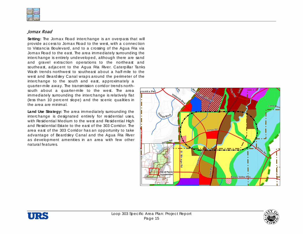
Jomax Road Setting: The Jomax Road interchange is an overpass that will provide access to Jomax Road to the west, with a connection to Vistancia Boulevard, and to a crossing of the Agua Fria via Jomax Road to the east. The area immediately surrounding the interchange is entirely undeveloped, although there are sand and gravel extraction operations to the northeast and southeast, adjacent to the Agua Fria River. Caterpillar Tanks Wash trends northwest to southeast about a half-mile to the west and Beardsley Canal wraps around the perimeter of the interchange to the south and east, approximately a quarter-mile away. The transmission corridor trends north-south about a quarter-mile to the west. The area immediately surrounding the interchange is relatively flat (less than 10 percent slope) and the scenic qualities in the area are minimal.
Land Use Strategy: The area immediately surrounding the interchange is designated entirely for residential uses, with Residential Medium to the west and Residential High and Residential Estate to the east of the 303 Corridor. The area east of the 303 Corridor has an opportunity to take advantage of Beardsley Canal and the Agua Fria River as development amenities in an area with few other natural features.

Loop 303 Specific Area Plan: Project Report Page 16
Lone Mountain Parkway Setting: The Lone Mountain Parkway interchange lies in a currently undeveloped area, with hilly terrain to the north and west and excellent high quality scenic views to the north and east. It will provide the most direct access to the proposed Vistancia Town Center from the 303, as well as access across the Agua Fria on the Dynamite Boulevard alignment that passes north of the Pleasant Valley subdivision, then connects with Westwing Parkway at Lake Pleasant Parkway. This east-west corridor will provide a scenic linkage from Surprise to the west through the Peoria foothills and Vistancia to the 303.
Land Use Strategy: This is the most urban of the interchanges in the Study Area. Based on its proximity to the planned Vistancia Town Center, as well as its location compared with Regional Commercial centers proposed elsewhere in the Northwest Valley, the area surrounding the Lone Mountain interchange is proposed for regional-scale commercial uses. The land immediately adjacent to the interchange provides an opportunity for uses that would complement, and not compete with, the anticipated “lifestyle” center at Vistancia. This could include automobile dealerships, which would benefit from the visibility afforded by the freeway. The area to the northeast of the interchange calls for development of Business Park uses. There is also an opportunity to develop a collector roadway network that knits together development that is otherwise oriented to the freeway interchanges, particularly to establish connections with residential areas near the adjacent interchanges (i.e., Jomax and Westland).
Loop 303 Specific Area Plan: Project Report Page 17
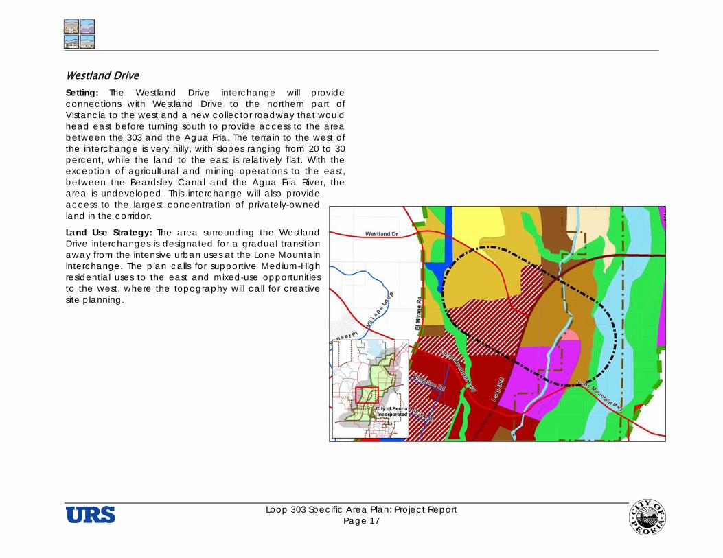
Westland Drive Setting: The Westland Drive interchange will provide connections with Westland Drive to the northern part of Vistancia to the west and a new collector roadway that would head east before turning south to provide access to the area between the 303 and the Agua Fria. The terrain to the west of the interchange is very hilly, with slopes ranging from 20 to 30 percent, while the land to the east is relatively flat. With the exception of agricultural and mining operations to the east, between the Beardsley Canal and the Agua Fria River, the area is undeveloped. This interchange will also provide access to the largest concentration of privately-owned land in the corridor.
Land Use Strategy: The area surrounding the Westland Drive interchanges is designated for a gradual transition away from the intensive urban uses at the Lone Mountain interchange. The plan calls for supportive Medium-High residential uses to the east and mixed-use opportunities to the west, where the topography will call for creative site planning.
Loop 303 Specific Area Plan: Project Report Page 18
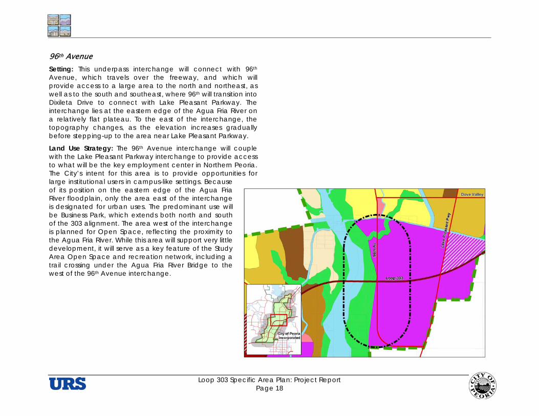
96th Avenue Setting: This underpass interchange will connect with 96th Avenue, which travels over the freeway, and which will provide access to a large area to the north and northeast, as well as to the south and southeast, where 96th will transition into Dixileta Drive to connect with Lake Pleasant Parkway. The interchange lies at the eastern edge of the Agua Fria River on a relatively flat plateau. To the east of the interchange, the topography changes, as the elevation increases gradually before stepping-up to the area near Lake Pleasant Parkway.
Land Use Strategy: The 96th Avenue interchange will couple with the Lake Pleasant Parkway interchange to provide access to what will be the key employment center in Northern Peoria. The City’s intent for this area is to provide opportunities for large institutional users in campus-like settings. Because of its position on the eastern edge of the Agua Fria River floodplain, only the area east of the interchange is designated for urban uses. The predominant use will be Business Park, which extends both north and south of the 303 alignment. The area west of the interchange is planned for Open Space, reflecting the proximity to the Agua Fria River. While this area will support very little development, it will serve as a key feature of the Study Area Open Space and recreation network, including a trail crossing under the Agua Fria River Bridge to the west of the 96th Avenue interchange.

Loop 303 Specific Area Plan: Project Report Page 19
Lake Pleasant Parkway Setting: The 303 will pass under Lake Pleasant Parkway with interchange connections to the Parkway. The area immediately surrounding the interchange is relatively flat, but drops about 100 feet down to a plateau about a third of a mile west of Lake Pleasant Parkway. To the southeast of the interchange is the New River impoundment area, which extends south along the eastern side of Lake Pleasant Parkway. This area provides an expansive area of wildlife habitat.
Land Use Strategy: As noted under the discussion of the 96th Avenue interchange, the Lake Pleasant Parkway interchange will couple with the 96th Avenue interchange to provide access to what will be Northern Peoria’s largest employment center, with opportunities for large institutional users in campus-like settings. This will consist predominantly of Business Park uses to the west and southeast of the interchange. The area to the immediate northeast of the interchange is planned for Mixed Use-Business Park uses.
Loop 303 Specific Area Plan: Project Report Page 20
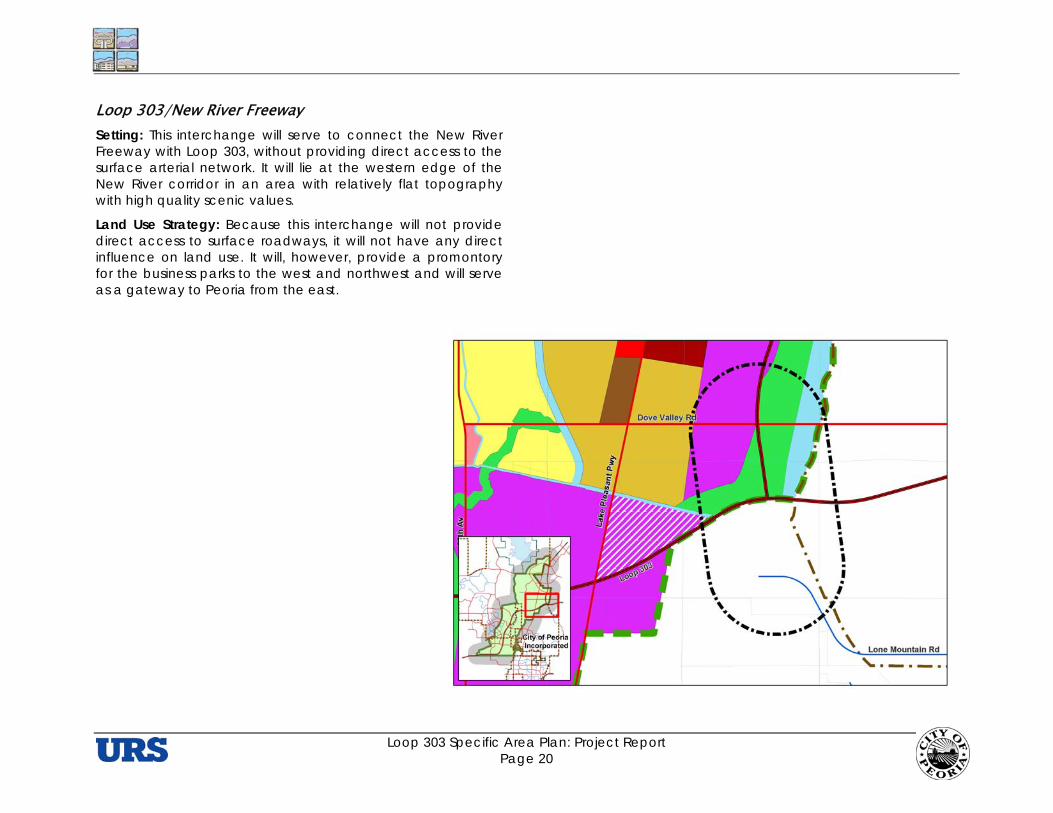
Loop 303/New River Freeway Setting: This interchange will serve to connect the New River Freeway with Loop 303, without providing direct access to the surface arterial network. It will lie at the western edge of the New River corridor in an area with relatively flat topography with high quality scenic values.
Land Use Strategy: Because this interchange will not provide direct access to surface roadways, it will not have any direct influence on land use. It will, however, provide a promontory for the business parks to the west and northwest and will serve as a gateway to Peoria from the east.

Loop 303 Specific Area Plan: Project Report Page 21
Loop 303-Carefree Highway Connector/Carefree Highway Setting: This interchange will connect the Loop 303 Connector with the Carefree Highway at the western edge of the New River, providing access to the travelers bound for Lake Pleasant and Wickenburg to the northwest and Phoenix and I-17 to the east and northeast. ADOT, working with local governments, has identified the alignment for the future New River Freeway, which will extend north of the Carefree Highway interchange.
Land Use Strategy: The plan calls for significant departures from previous assumptions for land use in the area. These include a shift in the “center of gravity” in the area from Lake Pleasant Parkway to the New River Freeway and a downscaling in the amount of commercial that had been shown for the area. The shift in gravity responds to the newly planned freeway access. The downscaling responds to plans for new Regional Commercial uses that are being planned for the Carefree Highway-I-17 interchange (about five miles to the east), the presence of the City of Phoenix’ 225-acre Lake Pleasant Water Treatment Plant to the northwest, and the prospect of a new regional airport to the north. The plan now calls for a large concentration of Business Park uses to the southwest and a significantly reduced amount of Community Commercial and Regional Commercial to the northwest and west of the interchange. It also calls for all the area west of Lake Pleasant Parkway to develop with residential uses at higher densities than
previously assumed (i.e., Residential Medium).
New River Freeway/SR 74 The area along the future eastward extension of SR 74, which is north of the currently proposed New River Freeway interchanges, lies outside of Peoria’s current City limits, within Phoenix. This area will require ongoing collaboration between the two Cities to determine an appropriate mix of uses as Phoenix sharpens its focus on the area, particularly as it relates to the potential for a new airport. This collaboration would be an extension of historical discussions concerning joint planning for development along the previously undefined New River Freeway alignment.
Loop 303 Specific Area Plan: Project Report Page 22
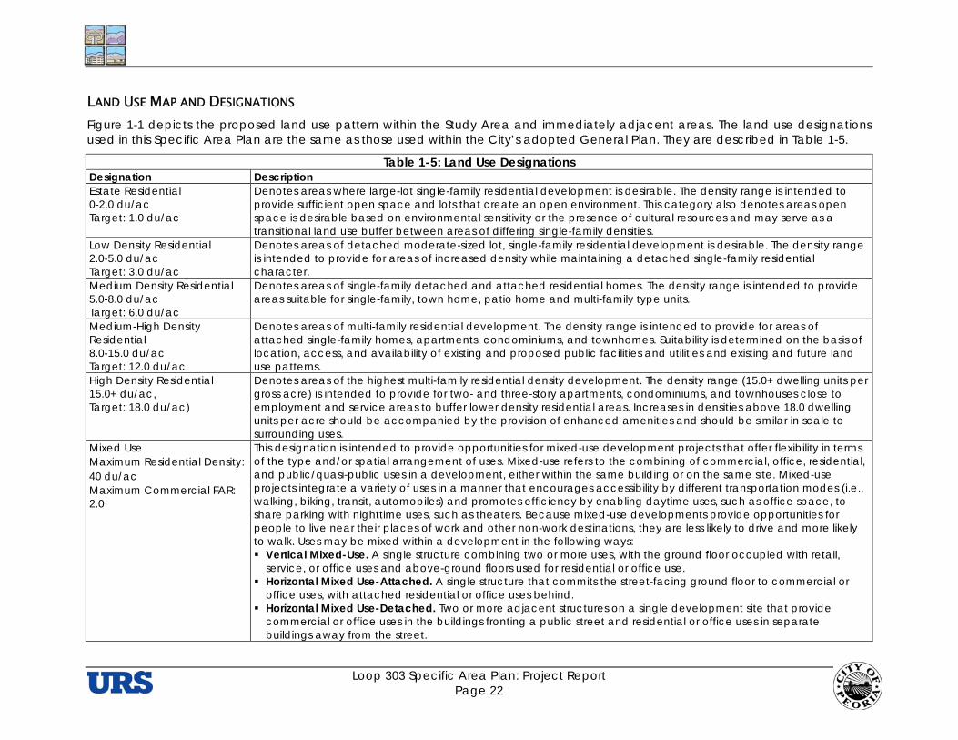
LAND USE MAP AND DESIGNATIONS Figure 1-1 depicts the proposed land use pattern within the Study Area and immediately adjacent areas. The land use designations used in this Specific Area Plan are the same as those used within the City’s adopted General Plan. They are described in Table 1-5.
Table 1-5: Land Use Designations Designation Description Estate Residential 0-2.0 du/ac Target: 1.0 du/ac
Denotes areas where large-lot single-family residential development is desirable. The density range is intended to provide sufficient open space and lots that create an open environment. This category also denotes areas open space is desirable based on environmental sensitivity or the presence of cultural resources and may serve as a transitional land use buffer between areas of differing single-family densities.
Low Density Residential 2.0-5.0 du/ac Target: 3.0 du/ac
Denotes areas of detached moderate-sized lot, single-family residential development is desirable. The density range is intended to provide for areas of increased density while maintaining a detached single-family residential character.
Medium Density Residential 5.0-8.0 du/ac Target: 6.0 du/ac
Denotes areas of single-family detached and attached residential homes. The density range is intended to provide areas suitable for single-family, town home, patio home and multi-family type units.
Medium-High Density Residential 8.0-15.0 du/ac Target: 12.0 du/ac
Denotes areas of multi-family residential development. The density range is intended to provide for areas of attached single-family homes, apartments, condominiums, and townhomes. Suitability is determined on the basis of location, access, and availability of existing and proposed public facilities and utilities and existing and future land use patterns.
High Density Residential 15.0+ du/ac, Target: 18.0 du/ac)
Denotes areas of the highest multi-family residential density development. The density range (15.0+ dwelling units per gross acre) is intended to provide for two- and three-story apartments, condominiums, and townhouses close to employment and service areas to buffer lower density residential areas. Increases in densities above 18.0 dwelling units per acre should be accompanied by the provision of enhanced amenities and should be similar in scale to surrounding uses.
Mixed Use Maximum Residential Density: 40 du/ac Maximum Commercial FAR: 2.0
This designation is intended to provide opportunities for mixed-use development projects that offer flexibility in terms of the type and/or spatial arrangement of uses. Mixed-use refers to the combining of commercial, office, residential, and public/quasi-public uses in a development, either within the same building or on the same site. Mixed-use projects integrate a variety of uses in a manner that encourages accessibility by different transportation modes (i.e., walking, biking, transit, automobiles) and promotes efficiency by enabling daytime uses, such as office space, to share parking with nighttime uses, such as theaters. Because mixed-use developments provide opportunities for people to live near their places of work and other non-work destinations, they are less likely to drive and more likely to walk. Uses may be mixed within a development in the following ways: Vertical Mixed-Use. A single structure combining two or more uses, with the ground floor occupied with retail,
service, or office uses and above-ground floors used for residential or office use. Horizontal Mixed Use-Attached. A single structure that commits the street-facing ground floor to commercial or
office uses, with attached residential or office uses behind. Horizontal Mixed Use-Detached. Two or more adjacent structures on a single development site that provide
commercial or office uses in the buildings fronting a public street and residential or office uses in separate buildings away from the street.
Loop 303 Specific Area Plan: Project Report Page 23
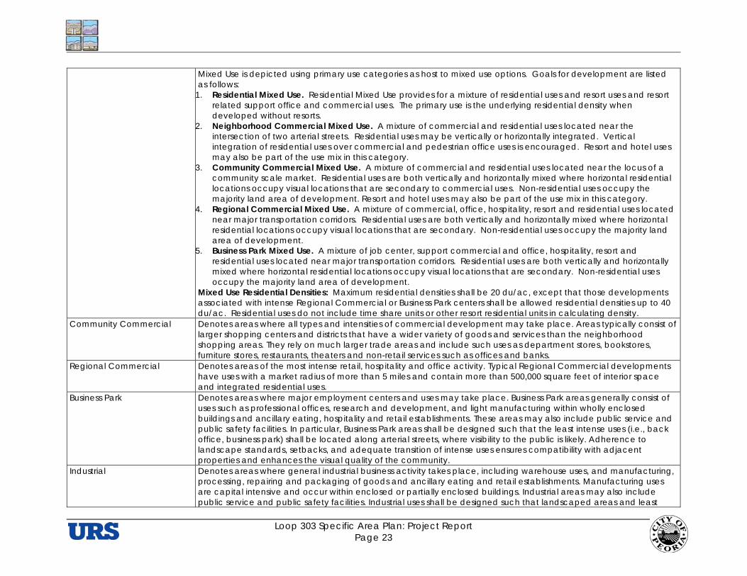
Mixed Use is depicted using primary use categories as host to mixed use options. Goals for development are listed as follows:
1. Residential Mixed Use. Residential Mixed Use provides for a mixture of residential uses and resort uses and resort related support office and commercial uses. The primary use is the underlying residential density when developed without resorts.
2. Neighborhood Commercial Mixed Use. A mixture of commercial and residential uses located near the intersection of two arterial streets. Residential uses may be vertically or horizontally integrated. Vertical integration of residential uses over commercial and pedestrian office uses is encouraged. Resort and hotel uses may also be part of the use mix in this category.
3. Community Commercial Mixed Use. A mixture of commercial and residential uses located near the locus of a community scale market. Residential uses are both vertically and horizontally mixed where horizontal residential locations occupy visual locations that are secondary to commercial uses. Non-residential uses occupy the majority land area of development. Resort and hotel uses may also be part of the use mix in this category.
4. Regional Commercial Mixed Use. A mixture of commercial, office, hospitality, resort and residential uses located near major transportation corridors. Residential uses are both vertically and horizontally mixed where horizontal residential locations occupy visual locations that are secondary. Non-residential uses occupy the majority land area of development.
5. Business Park Mixed Use. A mixture of job center, support commercial and office, hospitality, resort and residential uses located near major transportation corridors. Residential uses are both vertically and horizontally mixed where horizontal residential locations occupy visual locations that are secondary. Non-residential uses occupy the majority land area of development.
Mixed Use Residential Densities: Maximum residential densities shall be 20 du/ac, except that those developments associated with intense Regional Commercial or Business Park centers shall be allowed residential densities up to 40 du/ac. Residential uses do not include time share units or other resort residential units in calculating density.
Community Commercial Denotes areas where all types and intensities of commercial development may take place. Areas typically consist of larger shopping centers and districts that have a wider variety of goods and services than the neighborhood shopping areas. They rely on much larger trade areas and include such uses as department stores, bookstores, furniture stores, restaurants, theaters and non-retail services such as offices and banks.
Regional Commercial Denotes areas of the most intense retail, hospitality and office activity. Typical Regional Commercial developments have uses with a market radius of more than 5 miles and contain more than 500,000 square feet of interior space and integrated residential uses.
Business Park Denotes areas where major employment centers and uses may take place. Business Park areas generally consist of uses such as professional offices, research and development, and light manufacturing within wholly enclosed buildings and ancillary eating, hospitality and retail establishments. These areas may also include public service and public safety facilities. In particular, Business Park areas shall be designed such that the least intense uses (i.e., back office, business park) shall be located along arterial streets, where visibility to the public is likely. Adherence to landscape standards, setbacks, and adequate transition of intense uses ensures compatibility with adjacent properties and enhances the visual quality of the community.
Industrial Denotes areas where general industrial business activity takes place, including warehouse uses, and manufacturing, processing, repairing and packaging of goods and ancillary eating and retail establishments. Manufacturing uses are capital intensive and occur within enclosed or partially enclosed buildings. Industrial areas may also include public service and public safety facilities. Industrial uses shall be designed such that landscaped areas and least

Loop 303 Specific Area Plan: Project Report Page 24
intense uses shall be located adjacent to arterial and collector streets, where visibility to the public is likely. Industrial developments shall be designed to buffer adjacent residential uses from impacts associated with industrial activity.
Park/Open Space Denotes areas precluded from development except for open space and recreational facilities. Open space areas should remain in a relatively natural state (or be restored to such) due to topographic or other natural conditions. Lands identified as park or open space may be developed at a maximum density of one dwelling unit per acre per state legislative requirements.
Resort Denotes areas where the exceptional scenic and environmental quality may provide a site for a destination hotel, casitas or timeshare residential housing, golf/tennis, recreational and/or shopping opportunities, and/or hiking/equestrian trails. Potential generalized areas that may offer a resort setting are identified as asterisks on the Land Use Plan. However, the City may consider other undesignated resort sites based on the submittal of compelling project proposals.
Public/Quasi-public Denotes a use owned or operated by a governmental, nonprofit, religious, or philanthropic institution and provides governmental, educational, cultural, recreation, religious, or similar services.
Source: Peoria General Plan
LAND USE DISTRIBUTION Table 1-6 presents the acreage distribution of the land use depicted on the Land Use and Circulation Plan (Figure 1-1).
Table 1-6: Recommended Land Use Distribution Land Use Designation Acreage % of Total Residential/Estate (0 to 2 du/ac) 1,049 5.0 Residential/Low (2 to 5 du/ac) 3,759 18.1 Residential Mixed use 249 1.2 Residential/Medium (5 to 8 du/ac) 2,828 13.6 Residential/Medium High (8 to 15 du/ac) 679 3.3 Residential/High (15 du/ac and up) 767 3.7 Business Park/Industrial 409 2.0 Business Park 2,464 11.7 Business Park Mixed Use 351 1.7 Industrial 177 0.9 Neighborhood Commercial 45 0.2 Neighborhood Commercial Mixed Use 99 0.5 Community Commercial 369 1.8 Regional Commercial 626 3.0 Regional Commercial Mixed Use 621 3.0 Public/Quasi-Public 351 1.7 Parks and Open Space 3,727 17.8 Water (flow channels of Agua Fria and New Rivers) 2,253 10.8
Total 20,800± 100.0
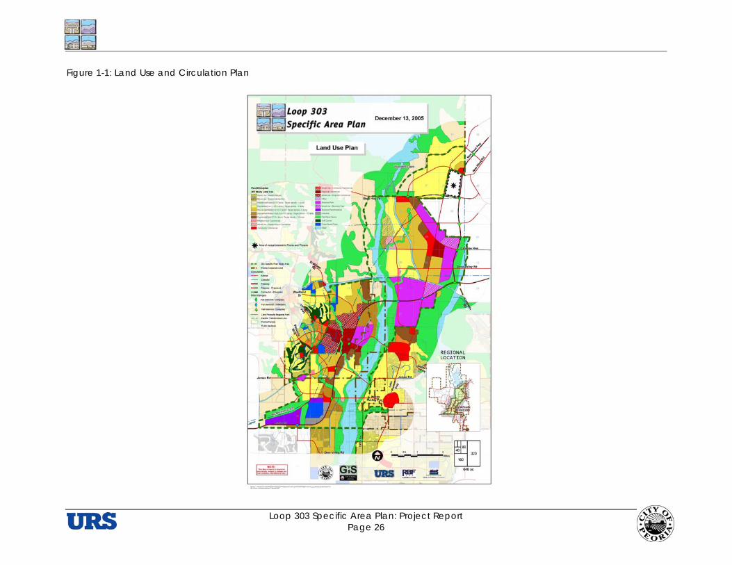
Loop 303 Specific Area Plan: Project Report Page 26
Figure 1-1: Land Use and Circulation Plan
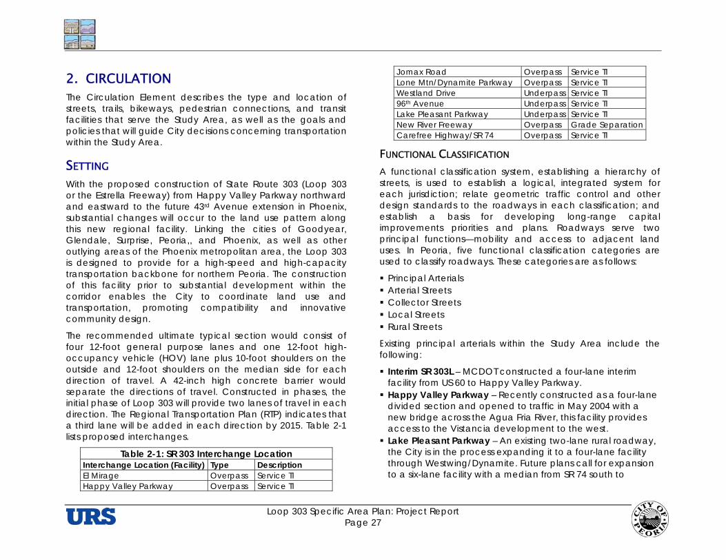
Loop 303 Specific Area Plan: Project Report Page 27
2. CIRCULATION The Circulation Element describes the type and location of streets, trails, bikeways, pedestrian connections, and transit facilities that serve the Study Area, as well as the goals and policies that will guide City decisions concerning transportation within the Study Area.
SETTING With the proposed construction of State Route 303 (Loop 303 or the Estrella Freeway) from Happy Valley Parkway northward and eastward to the future 43rd Avenue extension in Phoenix, substantial changes will occur to the land use pattern along this new regional facility. Linking the cities of Goodyear, Glendale, Surprise, Peoria,, and Phoenix, as well as other outlying areas of the Phoenix metropolitan area, the Loop 303 is designed to provide for a high-speed and high-capacity transportation backbone for northern Peoria. The construction of this facility prior to substantial development within the corridor enables the City to coordinate land use and transportation, promoting compatibility and innovative community design.
The recommended ultimate typical section would consist of four 12-foot general purpose lanes and one 12-foot high-occupancy vehicle (HOV) lane plus 10-foot shoulders on the outside and 12-foot shoulders on the median side for each direction of travel. A 42-inch high concrete barrier would separate the directions of travel. Constructed in phases, the initial phase of Loop 303 will provide two lanes of travel in each direction. The Regional Transportation Plan (RTP) indicates that a third lane will be added in each direction by 2015. Table 2-1 lists proposed interchanges.
Table 2-1: SR 303 Interchange Location Interchange Location (Facility) Type Description El Mirage Overpass Service TI Happy Valley Parkway Overpass Service TI
Jomax Road Overpass Service TI Lone Mtn/Dynamite Parkway Overpass Service TI Westland Drive Underpass Service TI 96th Avenue Underpass Service TI Lake Pleasant Parkway Underpass Service TI New River Freeway Overpass Grade Separation Carefree Highway/SR 74 Overpass Service TI
FUNCTIONAL CLASSIFICATION A functional classification system, establishing a hierarchy of streets, is used to establish a logical, integrated system for each jurisdiction; relate geometric traffic control and other design standards to the roadways in each classification; and establish a basis for developing long-range capital improvements priorities and plans. Roadways serve two principal functions—mobility and access to adjacent land uses. In Peoria, five functional classification categories are used to classify roadways. These categories are as follows:
Principal Arterials Arterial Streets Collector Streets Local Streets Rural Streets
Existing principal arterials within the Study Area include the following:
Interim SR 303L – MCDOT constructed a four-lane interim facility from US 60 to Happy Valley Parkway.
Happy Valley Parkway – Recently constructed as a four-lane divided section and opened to traffic in May 2004 with a new bridge across the Agua Fria River, this facility provides access to the Vistancia development to the west.
Lake Pleasant Parkway – An existing two-lane rural roadway, the City is in the process expanding it to a four-lane facility through Westwing/Dynamite. Future plans call for expansion to a six-lane facility with a median from SR 74 south to
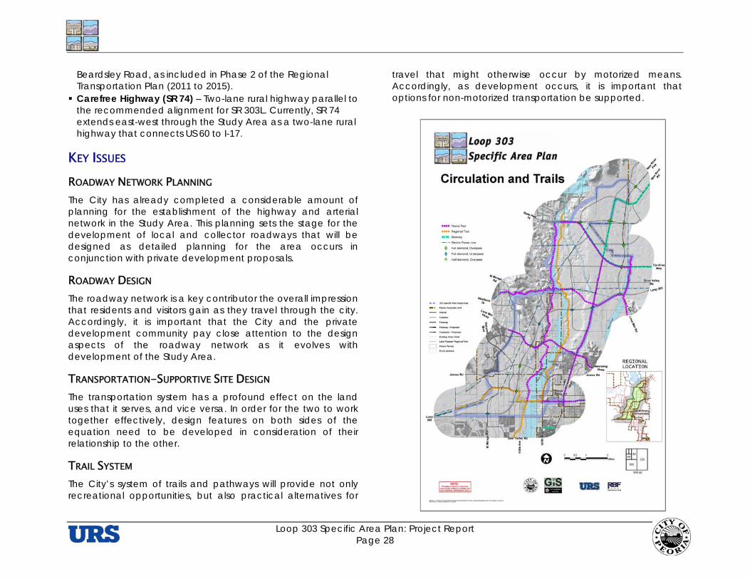
Loop 303 Specific Area Plan: Project Report Page 28
Beardsley Road, as included in Phase 2 of the Regional Transportation Plan (2011 to 2015).
Carefree Highway (SR 74) – Two-lane rural highway parallel to the recommended alignment for SR 303L. Currently, SR 74 extends east-west through the Study Area as a two-lane rural highway that connects US 60 to I-17.
KEY ISSUES ROADWAY NETWORK PLANNING The City has already completed a considerable amount of planning for the establishment of the highway and arterial network in the Study Area. This planning sets the stage for the development of local and collector roadways that will be designed as detailed planning for the area occurs in conjunction with private development proposals.
ROADWAY DESIGN The roadway network is a key contributor the overall impression that residents and visitors gain as they travel through the city. Accordingly, it is important that the City and the private development community pay close attention to the design aspects of the roadway network as it evolves with development of the Study Area.
TRANSPORTATION-SUPPORTIVE SITE DESIGN The transportation system has a profound effect on the land uses that it serves, and vice versa. In order for the two to work together effectively, design features on both sides of the equation need to be developed in consideration of their relationship to the other.
TRAIL SYSTEM The City’s system of trails and pathways will provide not only recreational opportunities, but also practical alternatives for
travel that might otherwise occur by motorized means. Accordingly, as development occurs, it is important that options for non-motorized transportation be supported.

Loop 303 Specific Area Plan: Project Report Page 29
GOALS AND POLICIES ROADWAY NETWORK Goal 2.1 To establish an interconnected hierarchical
roadway network that provides for efficient traffic operations while encouraging walking, bicycling, and transit use.
2.1.1 The City shall ensure that the Study Area roadway network responds to natural features of the area, particularly the two river corridors, the major washes, and the topography.
2.1.2 The City shall require developers to design local neighborhood roadway networks that provide internal connectivity so that pedestrian, bicycle, and automobile traffic can avoid reliance on the arterial street system for local trips, as well as to discourage non-local or through traffic while ensuring a minimum of two access routes to neighborhoods for emergency and service vehicles.
2.1.3 The City shall design collector roadways to provide convenient and vehicular and non-vehicular travel between neighborhoods and nearby activity centers, recreation areas, and schools.
2.1.4 The City shall design arterial streets so that direct access from individual parcels is limited. Access will be controlled through the use of median-divided arterials, frontage roads and background collector streets and vehicle non-access easements. A uniform spacing pattern of all new driveways and median breaks shall be required to simplify timing to support progression for traffic signals.
2.1.5 The City shall require the integration of non-vehicular trails into neighborhoods that provide both internal and external circulation within and between neighborhoods
and adjacent areas. This includes the reservation of sufficient rights-of-way to accommodate such trails.
2.1.6 The City shall discourage private streets unless they meet the adopted standards and that the benefit to the City exceeds the liability.
2.1.7 The City shall ensure that major roadway wash crossings (collector streets and above) are designed to be hydraulically efficient and environmentally sensitive with minimum disruptions or impacts to riparian areas and wildlife habitat.
ROADWAY DESIGN Goal 2.2 To design streets and roadways with features that
promote safe and convenient vehicular, pedestrian, bicycle, and transit use while maintaining high levels of aesthetic amenities.
2.2.1 The City shall incorporate physical design features into streets that promote safe and convenient travel. This should include the following, at a minimum: Distinctive crosswalks at major street intersections in
neighborhoods, activity centers, commercial corridors, transit stops, and near parks and schools.
Separated paths or lanes for bicycles and pedestrians.
Signage and traffic control devices to safely accommodate pedestrians, bicyclists, and vehicles.
Intersections with the minimum dimensions and turning radii necessary to maintain established levels of service.
Traffic calming techniques on local streets to discourage cut-through trips, slow traffic, promote walkability, and enhance safety.
2.2.2 The City shall ensure that streets include aesthetically appealing streetscapes that, as appropriate, feature the following:
Loop 303 Specific Area Plan: Project Report Page 30
Street trees Sidewalks Planting strips Benches Pedestrian-scale streetlights Landscaped medians Wayfinding/identity signage Bus Shelters Bus Turnouts
TRANSPORTATION-SUPPORTIVE SITE DESIGN Goal 2.3 To encourage site design that promotes multi-
modal access to development.
2.3.1 The City shall require all residential, commercial, and industrial development projects to provide direct access for pedestrians and bicyclists.
2.3.2 The City shall discourage the placement of physical barriers (e.g., fences, walls, and other impenetrable structures) between neighborhoods that impedes safe and convenient pedestrian and bicycle access between uses.
2.3.3 The City shall encourage all development along existing and planned transit routes to orient to transit stops by providing pedestrian amenities and convenient access and designing buildings to face transit facilities. This includes all new, infill, reuse, or redevelopment projects.
2.3.4 The City shall encourage site design, including site and building access that accommodates the needs of pedestrians and bicyclists by providing direct access from sidewalks and parking areas to building entrances while minimizing conflicts with automobile and truck traffic.
2.3.5 The City shall require the integration of pedestrian shelters in public areas (e.g., awnings, shade trees).
2.3.6 The City shall require site design that provides convenient and secure parking for bicycles.
TRAIL SYSTEM Goal 2.4 Develop a comprehensive, coordinated, and
continuous on and off-street bicycle and multi-use trail system.
2.4.1 The City shall encourage the incorporation of bike facilities and access to trail systems into new developments to promote bicycle and pedestrian use.
2.4.2 The City shall require bicycle lanes on all new arterial and collector roadways within the Study Area.
2.4.3 The City shall collaborate with the City of Phoenix and Maricopa County to ensure trail connectivity at municipal boundaries.
2.4.4 The City shall promote the development of equestrian use facilities in conjunction with regional trail systems, existing equestrian facilities, designated open space areas, and within the Agua Fria and New River corridors.
2.4.5 Revise the City’s Trails Master Plan to incorporate a network of trails designed to serve the land use pattern depicted within the Loop 303 Specific Area Plan.
CIRCULATION PLAN The Circulation Plan for the Study Area is depicted in Figure 1-1. It relies on the City’s existing plans for the development of an arterial network that is coordinated with the County and State highways that serve the area.
Loop 303 Specific Area Plan: Project Report Page 31
3. PARKS, TRAILS, AND OPEN SPACE
SETTING The importance in developing a seamless park, trails and natural open space system that complements the planned land use and circulation patterns for the Study Area cannot be overstated. The should leverage the proximity of the Agua Fria and New Rivers to design a system of open space and recreation and trails corridors that bring connectivity and linkages throughout the Study Area and beyond. These corridors should support, not detract from, the land use and transportation network that will guide growth and development within the Study Area. While the Study Area will be a focus for quality residential, employment and sales tax growth opportunities for the City, establishing recreation opportunities for these future residents and trail linkages to connect them will aid in creating a cohesive community that may otherwise be bifurcated through the construction of a grade separated freeway. Examples abound across the United States where grade separated transportation corridors, whether freeways or public transit systems, continually challenge the ability to maintain a cohesive fabric of the community and not create unwanted buffers.
Numerous adopted plans and reports that guide the City decision making process relative to parks, trails and recreation have been completed. This Plan is designed to further many of those concepts and policy objectives, but also refine these visions with and through the comprehensive planning process of this Specific Area Plan.
Much of the lands within the Study Area is held in the State Trust and managed by the State Land Department (ASLD). Is it essential that the City maintain open lines of communication with ASLD to establish future trail alignments to maintain regional connectivity as well as plan for park facilities to complement future master plans as these properties are
conveyed to private development through the disposition process.
KEY ISSUES RIVER CORRIDORS AND ADJACENT TRAIL CONNECTIONS The City of Peoria has benefited from the various master plans and studies previously undertaken to gain a comprehensive understanding of the local and regional value of establishing trail and recreation facilities throughout the Agua Fria and New River systems. While these studies yield a holistic analysis of these systems, this Specific Area Plan builds upon the foundation of those planning efforts by focusing on refined land use patterns and the Loop 303 alignment to bring clarity to the interface of the Agua Fria and New Rivers within the Study Area.
It is clear that the potential to create a seamless trail and linear park system within these river corridors is enormous. Bringing this vision to reality will require the steady and timely collaboration with a variety of public and private sector interests.
Clearly, the cooperation of the sand and gravel operators currently operating within these river corridors is necessary. A partnership with the sand and gravel operators is needed to achieve the short tem objectives of channelizing certain portions of these rivers, but also seek long-term reclamation plan(s) for transition to use as recreation facilities. An agreement to memorialize common objectives in order to better understand how the role of the sand and gravel operations interface with incoming development is suggested.
Providing multi-use trail inter-connectivity between local/regional utility easements, natural washes, private property and the Agua Fria and New Rivers will greatly enhance the livability and appeal of North Peoria in its entirety. This connectivity can begin to be planned by establishing trailheads to give a “front door” to the trail and park systems at
Loop 303 Specific Area Plan: Project Report Page 32
strategic locations where “criss-cross” connections can pull this network together and use Loop 303 as access to do so. Multi-use and equestrian trailheads at Lake Pleasant Parkway and the CAP canal and at the intersection of Loop 303 (at interchange location #1) and McMicken Dam Outlet Wash (Discovery Trail) will provide easy access to hillside and river experiences within and around the Study Area. With these trailheads established at opposing ends of the Study Area, primary connection to the Maricopa Trail will provide the main trail link between them.
With the creation of this Specific Area Plan, an opportunity to design a unique series of trail features, with varying character, can greatly promote this area as unprecedented seamless trails connecting the multitude of future developments and the natural systems surrounding them. The McMicken Dam Outlet Wash, Twin Buttes Wash, and Caterpillar Tank Wash are all excellent examples of where linkages from neighboring master planned communities, future employment and retail uses and the natural systems can create extensive continuity in the trail network within the Study Area. The McMicken Outlet Wash, known as the Discovery Trail as it connects to the Vistancia community, is encouraged to evolve into a fully accessible public trail to provide regional connectivity to areas within and outside the Study Area. Trail character, as it flows from built environment to natural open spaces, should be designed with educational and interpretive markings and structures that reflect the prominence of Lake Pleasant and its heritage.
The development of the Maricopa Trail along the eastern edge of the Agua Fria is also critical for providing local and regional trail connectivity. The City must continue to collaborate with the development community to ensure adequate lands be set aside for this trail and linear park system. In those areas along the river system where developer initiated plans are not practical, the City should consider examining the CIP to secure monies for construction of these areas, such as the area from Dixileta Road north to the CAP canal.
Multi-use trail designs linking both sides of the Loop 303 and minimizing the effects of bifurcation are critical for keeping a cohesive feel to the trail network within the Study Area. Where underpasses are designed at interchanges, the effects of bifurcation are lessened by designing eight-foot wide multi use paths in conjunction with the arterial crossing. Preferably separated by a landscape easement, this multi use trail will encourage the pedestrian to utilize the trail and not feel threatened by the freeway’s existence. The proposed underpasses at El Mirage Road, 96th Avenue and Lake Pleasant Parkway are suggested for improvement.
In instances where the Loop 303 utilizes passes over the arterial street network, minimizing the effects of bifurcation become more challenging. In these situations, additional connections should be designed using the natural wash system (such as Twin Buttes Wash in the case of the Happy Valley traffic interchange). Enhanced linear parks that double as drainage facilities around interchanges could also create a sense of openness and connection.
PARKS AND RECREATION Community and regional parks within the Study Area should provide a wide range of active and passive recreation uses and be entirely inter-connected with the trail system. Opportunities to partner with the Maricopa County Flood Control District to establish a joint-use large regional park south and east of the confluence of Deadman Wash and the New River is strongly encouraged. The area can be accessed by regional trail connections and also serve as a buffer between employment and residential uses in the area.
Collaboration with the State Land Department and private property owners will be necessary to determine appropriate size and locations for necessary parks to provide a desired level of service to accommodate the future growth. As State Trust Lands get planned and disposed of for private development, community and regional park locations should
Loop 303 Specific Area Plan: Project Report Page 33
be thoughtfully designed in concert with regional trail opportunities and natural river systems.
The North Peoria Park/Open Space and Trails Plan is in the process of evaluating appropriate park facility locations based this Specific Area Plan. It is also suggested here that the North Peoria Parks Plan evaluate the applicability of the existing Peoria park standards and take into account the significant natural and topographical resources that exist within this Study Area. More specifically, there may be a necessity to incorporate added natural open spaces versus constructing one neighborhood park per square mile in cases where adjacency to the rivers or hillsides may suggest alternative standards. Preservation of culturally significant lands or hillsides are offered as examples.
GOALS AND POLICIES SYSTEM PLANNING Goal 3.1 To coordinate the establishment of additional park
land and recreational facilities with other government agencies and private, non-profit entities.
3.1.1 The City shall explore innovative partnering opportunities with the Maricopa County Flood Control District and other stakeholders to leverage joint use and operation of regional park and flood control facilities near the area south of Loop 303 and Lone Mountain Road.
3.1.2 The City shall promote the establishment of a community park and potential recreation center on the recently acquired BLM property. Future master plan studies shall determine, based upon existing topographic constraints, the appropriate balance or facility needs for this site.
3.1.3 The City shall consider modifying its existing park requirement of one park per square mile within the Study Area. The prominence of diverse topography and valuable natural and culturally significant open spaces within the Study Area should give cause to explore alternative requirements.
3.1.4 The City shall continue to collaborate with the development community to incorporate new park facilities along regional open space and trail corridors
3.1.5 Complete the north Peoria Parks Master Plan, including identification and evaluation of desired community and regional park opportunities based upon the newly supported land uses within the Loop 303 corridor study area. This should include provision of guidance on ensuring effective trail linkages between newly defined employment and commercial centers, residential neighborhoods and the trail and open space systems within the Agua Fria and New River.
RIVER CORRIDOR SYSTEMS Goal 3.2 To plan and develop the Agua Fria and New River
Corridors to provide for continuous trail systems for non-motorized users while protecting natural and cultural resources and balancing the effects of urban development.
3.2.1 The City shall promote its proximity to the Lake Pleasant Regional Park and design educational and interpretive trail components within the Study Area that reflect local history and the prominence of Lake Pleasant.
3.2.2 The City shall give further study to the lands within and adjacent to the Agua Fria River to determine areas appropriate for additional linear parks and natural open spaces and conversely, which areas may be suitable for alteration of the floodplain (channelization) for utilization as significant development opportunities.

Loop 303 Specific Area Plan: Project Report Page 34
3.2.3 The City shall support a strong partnership with sand and gravel operators within the Study Area to develop a mutually beneficial plan to provide effective means for supporting near term channelization efforts and long term reclamation plans to aid in the development of recreation and trail opportunities within the Agua Fria River.
3.2.4 The City shall collaborate with Maricopa County in promoting the design and construction of the Maricopa Trail by working with developers early in the master planning process to set aside appropriate areas to accommodate the trail.
3.2.5 The City shall continue to stipulate that development projects adjacent to the Agua Fria and New Rivers designate and coordinate full public access to public open spaces and trails within these river corridors.
3.2.6 The City shall give further study to establishing an Agua Fria trail linkage to park and/or open space opportunities to the newly acquired BLM property.
3.2.7 The City shall utilize and update its Trails Master Plan and Rivers Master Plan to promote newly identified planning concepts and desired land uses identified in the Study Area.
TRAIL LINKAGES Goal 3.3 To provide for an integrated, public access trail
system that establishes linkages across and minimizes potential barrier effects of the Loop 303.
3.3.1 The City shall promote connectivity of regional trail systems, master planned communities and natural resources that together create a seamless transition between these land uses.
3.3.2 The City shall design a system of trails that adapt to the changing character of the Study Area by utilizing
urban, suburban, rural, and wilderness features as appropriate.
3.3.3 The City shall partner with the State Land Department to designate desired future trail alignments coordinated with newly defined land uses and trail connections so as to be planned and coordinated through the disposition process.
3.3.4 The City shall continue to collaborate with developers during entitlement and site planning processes to provide for the construction of regionally significant trails in close proximity to their respective developments.
3.3.5 The City shall promote full public access of the Discovery Trail to ensure a continuous linkage from the Agua Fria River to nearby master planned communities.
3.3.6 The City shall strongly support the provision of both multi-purpose and equestrian trail connections of the Agua Fria and New Rivers via the Hatfield Trail along power line corridors, including grade separations at intersections with arterial streets.
3.3.7 The City shall develop an Intergovernmental Agreement (or other means of agreement) with the Central Arizona Project (CAP) for the establishment of equestrian and multi-use trails along both sides of the canal.
3.3.8 The City shall update the Trails Plan to establish specific trail design standards and guidelines for the development of trails that are responsive to final design plans for the Loop 303.
3.3.9 The City should consider a review and update of the CIP to consider the inclusion of funding of the Maricopa Trail from Dixileta Road north to the CAP canal alignment.

Loop 303 Specific Area Plan: Project Report Page 35
4. PUBLIC FACILITIES AND SERVICES As this plan is put into action, it will essential for the City to provide for the timely expansion of all levels of public facilities to serve the Study Area. Supportive municipal services such as providing for a Municipal Operations Center, customer service center, expanded police and fire facilities, community and regional parks will collectively be essential to serve the Study Area.
BLM PROPERTY The recently acquired BLM property located just south of the Study Area is poised to address multiple City park and facility objectives. Upon final conveyance of the 160 acres of former BLM property, the City should conduct a master plan of the site to determine the appropriate mix of municipal operations to be placed at the site. While topography will limit some of the site’s utility, the site could host a future community park, recreation center, customer services center, and a field operations yard. If not too constrained by the site’s topography, further exploration should be given to co-locating other municipal operations as feasible. The site location is well suited to establish easily accessible, centralized municipal services for the future population and employment centers within the Study Area.
MUNICIPAL OPERATIONS CENTER Among the municipal uses being considered for the Study Area is a Municipal Operations Center (MOC) that would house a variety of City functions for the Study Area and Northern Peoria. Collaboration among the City’s Skunkworks group and other interested stakeholders will be essential to identifying the necessary services for residents and employers in the Study Area. As an interim measure, the recently-acquired BLM land could accommodate an MOC. As development of the area progresses, a site closer to Loop 303
would be desirable, ideally near the Lake Pleasant Parkway interchange.
PUBLIC SAFETY Expanded levels of fire and police service will be necessary within the population and employment centers of this Study Area. Fire Station #6 is currently under construction in Vistancia to serve the residents of that master planned community and it is expected that station will be capable of providing coverage to the southern portions of the Study Area. Though not programmed in the existing CIP, possible locations for future fire station facilities should be considered at the intersection of Lone Mountain Road and Lake Pleasant Parkway and adjacent to the Loop 303 within the employment and retail land uses along Westwing Parkway. The locations of these sites generally strive to achieve desirable response time standards for this area of Peoria.
In anticipation of growth within the Study Area, the opportunity for the Fire Department to refine its Wildland/Urban Interface Zone policies will be critical. As the new land use plan illustrates, many areas within the Study Area will quickly transition from rural, natural land uses to suburban and urban environments where Wildland/Urban Interface Zone practices and procedures will be essential.
Police Department operational needs differ from that of the Fire Department. As such, the future location of a Police Department substation in the northern part of the Study Area, near the intersection of Lake Pleasant Parkway and State Highway 74, would best respond to the land uses proposed with this Specific Area Plan. This location, while conceptual in nature, would provide administrative, processing and jail facilities for a centrally accessible location for North Peoria. While direct vehicular access to Lake Pleasant Parkway and State Highway 74 is not critical, the site should maintain arterial or major collector level road access within a three-mile radius of the intersection. The City is also considering a new police

Loop 303 Specific Area Plan: Project Report Page 36
substation near Lone Mountain Road and 99th Avenue, which would serve the southern part of the Study Area. It is also worth noting that programming Police Department workstation space within all new municipal facilities should be considered to provide flexible workspace for officer needs.
GOALS AND POLICIES MUNICIPAL OPERATIONS Goal 4.1 To promote the City’s ability to provide day-to-day
services within the Study Area to keep pace with anticipated growth.
4.1.1 Based upon the land uses identified within this Specific Area Plan, the City shall, in collaboration with interested stakeholders, extensively evaluate all City departments’ future operational and resource needs to maximize the location of a Municipal Operations Center (MOC) within the Study Area.
4.1.2 The City shall promote off-road, non-motorized trail connectivity to the future MOC property and shall secure necessary rights-of-way and/or easements to ensure trail connection to the regional trail systems within the Agua Fria River, New River, and Hatfield Trail.
4.1.3 The City shall explore potential partnerships with Maricopa County and neighboring communities to establish library facilities to meet the demands of future growth in the Study Area.
4.1.4 The City shall require developers of new master planned communities to set-aside land for the public facilities necessary to serve the development. In doing so, the developers should ensure sufficient space to provide buffers between these facilities and nearby residents.
4.1.5 Complete an assessment of municipal space needs for North Peoria.
4.1.6 Conduct a master planning process to fully evaluate physical opportunities and constraints associated with potential municipal operations center sites within the Study Area.
EDUCATION Goal 4.2 To support diverse, exceptional education
opportunities within the Study Area.
4.2.1 The City shall foster open lines of communication with Arizona State University and the Maricopa Community College system to promote the development of a post secondary educational institution that offers curriculum to meet City-defined employment objectives.
4.2.2 The City shall continue to partner with local unified school districts and charter schools to provide for the dedication/reservation of public school sites to support new growth within the Study Area.
4.2.3 The City shall continue to partner with local school districts to ensure that the planning and siting of future school sites allow for trail connections to localized and regional trail systems.
PUBLIC HEALTH AND SAFETY Goal 4.3 To provide for the efficient delivery of public safety
and other emergency services within the Study Area.
4.3.1 The City shall strongly support collaboration efforts with private-sector medical providers to establish a hospital or other urgent care facilities within the Study Area to serve the growing population within.
4.3.2 The City shall examine and establish Wildland/Urban Interface Zones within the Study Area.
4.3.3 The City shall explore the siting of new Police Substations strategically located within the Study Area. One possibility is within a 3-mile radius of the

Loop 303 Specific Area Plan: Project Report Page 37
intersection of Lake Pleasant Parkway and State Highway 74. Another is near the intersection of Lone Mountain Road and 99th Avenue. Any new substation should maintain vehicular ingress/egress from major collector or arterial roadways.
4.3.4 Based upon the newly defined land uses within the Study Area, the City shall monitor and update the CIP for the timely provision of fire stations to serve the Study Area.
INFRASTRUCTURE IMPROVEMENTS Goal 4.4 To provide for timely and coordinated infrastructure
improvements within the Study Area
4.4.1 The City shall continue to require that new development pay for added municipal infrastructure demands and support partnerships with large employers for construction of trunk systems to support employment growth within the Study Area.
4.4.2 The City shall incorporate the land use designations in this plan into future updates to the water and wastewater master plans.
4.4.3 The City shall identify critical infrastructure required to support the Specific Area Plan and review the City’s current Capital Improvement Program (CIP) for possible revisions.
WATER RESOURCES Goal 4.5 To provide for a renewable and sustainable water
supply
4.5.1 The City has identified that the water supplies currently available and projected to become available as defined within the Water Resources Master Plan should be sufficient to meet the water demands of the target density shown in the General Plan.
4.5.2 Based upon the prior objective, proposed development above the target density of the General Plan may require the developer to provide for additional water resources. Any additional water supplies must be consistent with the City’s Water Resources Master Plan and approved by the Utilities Director.
4.5.3 The City shall require developers to set-aside land for utilities facilities necessary to serve the development, which shall include, but not limited to water supply wells and sites, booster pumps, lift stations, etc.