Embed Size (px)
Citation preview

Long-Term Stewardship R3 RCRA CorrecOve AcOon
Joel Hennessy Land & Chemicals Division
EPA Region 3 April 19, 2017

Engineering Controls
• e.g., Landfill Cap, Fence, Asphalt Cover, Permeable ReacOve Barrier, etc.

InsOtuOonal Controls • Governmental • InformaOon
devices • Proprietary • Orders/Permits

Long Term Stewardship Approach
1. Mapping ICs and ECs 2. Maps and informaOon on public website
3. Record ICs and ECs in RCRAInfo (including GIS) 4. IC/EC Assurance Monitoring
5. Engage & update local officials
4

Mapping ICs and ECs • Property Boundary (for site-wide ICs) • Individual areas (AULs, specific ECs) • ESRI ArcGIS Online maps for website (GeoplaNorm) • GIS data in RCRAInfo database • GeospaOal PDF • Improve standard of pracOce for environmentalcovenant mapping and figures – Metes & bounds – Figures – Coordinates – Geographic data validaOon
5

6
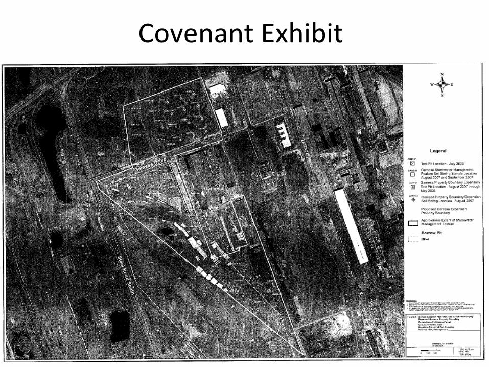
Covenant Exhibit
7

8
Improved Exhibit: • VerOcesshown • Coordinate table • Light or no background
• North arrow • Bar Scale • 8.5 X 11 • Can be copied in B/ W mulOple Omes

9

10

11

12
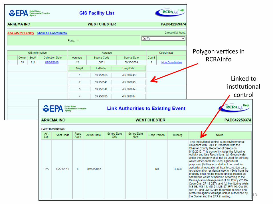
Polygon verOces in RCRAInfo
Linked to insOtuOonal control
13

InsOtuOonal & Engineering Event Codes in RCRAInfo
• Engineering Controls Established: – CA770NG (non-groundwater control) – CA770GW (groundwater control)
• InsOtuOonal Controls Established: – CA772GC (governmental control) – CA772PR (proprietary control) – CA772EP (enforcement & permit tools) – CA772ID (informaOon device)
14

RCRAInfo
• RCRA Program database • Sixmodules: – Handler Data
Event (what happened) Area (where did it happen) – Compliance, Monitoring Authority (what made it happen)
and Enforcement – Financial Assurance Data
Points, lines, or polygons Lat/Lon coordinates of verOces Includes other metadata (e.g., datum) Linked to Area
– PermiRng, Closure, Post-Closure Data – CorrecOve AcOon Data
– GIS Data
15


CIMC – Site Profile Page

Final Remedies with ICs & ECs – R3 (out of a 2020 GPRA Universe of 579 faciliOes)
State # Sites with IC and/or EC (in RCRAInfo)
# Sites Mapped
DC 1 0
DE 5 5
MD 18 10
PA 92 56
VA 47 27
WV 15 10
Region 3 RCRA CA 178 108
as of 10/4/2016
18

Long Term Stewardship Approach
1. Mapping ICs and ECs 2. Maps and informaOon on public website
3. Record ICs and ECs in RCRAInfo (including GIS) 4. IC/EC Assurance Monitoring
5. Engage & update local officials
19

IC/EC Assurance Monitoring
• Document review
• Site inspecOon checklist • Site inspecOon (w/ checklist and geospaOal PDF) • IC/EC Monitoring report • Goal: – Determine whether the IC/ECs are funcOoning and maintained
– IdenOfy and correct IC/EC deficiencies
20

GeospaOal PDF
• Adobe Acrobat PDF map • Contains georeference data • Both vector and raster informaOon • ESRI ArcMap can create geospaOal PDFs – Natural end product in GIS workflow – Project managers already familiar with PDFs – Opensin Avenza Maps App on iOS and Android devices
– Project managers can upload (no addiOonal GIS support needed)
21

22University of MD – Landfill Area 3 (MFRI)

23

What does an LTS evaluaOon look like? • PreparaOon
– Review remedy, recent data/reports – Develop checklist based on selected remedy and ICs/ECs – Maps gathered, brought into GIS
– Update geospaOal PDF
• InspecOon – Brief meeOng to discuss – Field tour – visit everything on checklist (using geospaOal PDF) – Photo documentaOon of current condiOons (geotagged) – Close-out meeOng
• Meet/contact with local municipality – Update with remedy status & progress; current points of contact – Ask about changes to land and water use, and any concerns they may have
• Follow-up – Prepare LTS report, post on web
– Work with facility to correct any IC/EC deficiencies – Record outcome in RCRAInfo
24

Example: BAE Systems, York, PA
25

26

LTS EvaluaOon Codes - RCRAInfo
• CAS88P: LT Stewardship – Pass – LTS assessment completed, all InsOtuOonal Controls and/orEngineering controls (IC/EC) are in place, maintained andoperated in the manner envisioned when EPA/State selectedthe remedy, and with current policies and pracOces
• CAS88N: LT Stewardship – Need addi;onal Informa;on – AddiOonal informaOon or changes in operaOon, maintenance ofthe IC/EC are needed to make a CAS88P determinaOon
• CAS88C: LT Stewardship – Compliance Review – Selected IC/EC are not in place, operated or maintained, orother issues are idenOfied that suggest the selected remedy isno longer appropriate for the current condiOons at the facility,therefore a comprehensive remedy compliance assessment isrequired
27

28

LTS Assessments State FY 2014 FY 2015 FY 2016 FY 2017
DC 0 0 0 0
DE 1 2 2 2
MD 3 1 0 0
PA 3 4 15 14
VA 5 9 7 5
WV 3 1 4 1
Region 3 RCRA 15 17 28 22
29

QuesOons?
Mapping and LTS Approach documents:
hQps://www.epa.gov/sites/producOon/files/2016-07/documents/ rcra_mapping_of_insOtuOonal_and_engineering_controls.pdf
hQps://www.epa.gov/sites/producOon/files/2016-07/documents/ r3ltsprogram_july2016.pdf
Cleanups in My Community:
hQps://www.epa.gov/cleanups/cleanups-my-community
30