Embed Size (px)
Citation preview

URITID S'l'ATlSDKPAIl.TMlHT OF TIIB nrrnIlJl
GEOLOGICAL suaVlY
LONG-TERM REGULATORY COMPLIANCE
GlOLOGY AID IllDJ.OLOGY (JI THE CAUSBAD pmASH AREA,IDDY UD LEA COOIttIBS, EW MEXICO
By
Arnold L. Brokaw, C. L. Jo.a, M. I. CODlay,and W. H. Beye
Open-fila report. 1972
Prepared underAgreement No. AT(40-1)-4339
for theDivision of Waste Management and Trainin&
U.S. Atomic Energy Commission
Thia report ia preliminary aDd baa not bean editad or raviewed forcoafor-ity with U.S. Geological Survey atandarda or na.8nclatare.
CONTENTS
Page
Ab.tr.ct~--------~----------------------------------------------
Introduction---------------------------------------------------- 3Ceo&~.phy------------------------------------------------------- 4
Location and population------------------------------------ 4
Surface water---------------------------------------------- 6Topolraphy------------------------------------------------- 1
Cuadalupe Hount.ins----------------------------------- 7
High Pl.in.~------------------------------------------ 8Low hilla--------------------------------------------- 8Pediment. and alluvial p1alne------------------------- 8
Coll.pee features------------------------------------- 10Clt.ate-----------------------------------~---------------- 11
Indu.try----------------------~---------------------------- 11
Acce••------------------------------------------------~---- 1)
Stratigraphy---------------------------------------------------- 13Preea.ortan ba.ement--------------------------------------- 14
Pre-Pendan Paleo&oie deposition--------------------------" 1.5
Permian depo.itioh--------------------------------------~-- 16
Wolfea.pian. Leonardian••nd Guadalupian Serles--~---- 16
Oehoan Serlea-·------------------_·--------------~---- 20
1

P.lsr.
Tri••• ic .nd Ct'eUceou. depo.1tio[I"~----------~--------~-~-· 26
Tertiary .nd Q~.ternary depo.ttlob--~------~------~------··- 27
Structure-- ----- --- .. ---- ---- ---- ~.~--------.---- --- ~----- ----~- .. -- ~9
Gener.l fe.tur4!l...------------- .. ---····--------- ----~---------- 28
Del.ware b••tn... ------------ ---------.0- --------------------- 30
Hortbwe.t .helf--------------------------------- .. ---------- 31
Centr.l ba.ta pl.tfora------------------------------------- 33
Ceolo&y of ••It depo.it.--Ochoan Serie.------------------------- 34
C..til. For__tlon-------------------------------- .. --------- 15
S.l.do Fo~tion------------------------------------------- 39
au.tl.r For..tlon-------------------------..---------------- 47
Dew.y Lak. a.db.d.----------------------------------------- 51
Ground-w.ter bydrololy------------------------------------------ ~]
Peco. River------------------------------------------------ ~]
W.ter-b••ring unit. ov.rlying S.l.do 'or.-t1on------------- ~3
S.lado For..tion------------------------------------------- ~9
Str.t. und.rlylna S.l.do For..tlon~---~----------------··-- 61
'otaah _In••-------------------- '••,-----.- •.-- ••.•~----------.----- 62
Hl.tory of .1nina-------------------·~·-----------·-------- 62
Location of .tne.---··-----·u.-------•• - •••------.. - ... _------.... &1
Method. of pro.p,cUna and .xploriltloll-·----------·----·--- 0':'

COHTENTS--Continued
Pase
Minina .ethods--------------------------------------------- 64
Sh.ft.------····----------------·-··-·--···----·······--... 6~
Extent of _ine workinas------------------------------------ 68
Stability of .ine workinls-------------------------------~- 69
CaviRl and subsidence-------------------------------------- 69
Gnaae .haft and workiaS.----------------------------------- 10
Solution .inlna actlvitles--------------------------------- 13
011 and .a. productioo------------------------------------------ 14
Conclu.iona----------------------------------------------------- 18
Selected reference.--------------------------------------------- 19
Appendix A. Reprint of Per.ian ba.in potash depo.lts •
•outh-we.tern United State. by C. L. Jones-------------------- (in pocket)
ill

ILLUSTRATIONS
Figure I.--Hap of the vicinity of the potaah mines,
aouthea.tern New Hexico----------------------
2.--Generalized stratigraphic column at Gnome
site and description of lateral variations---
3.·-Generalized geologic cro•••ection from south
to north through the vicinity of the Gne-e
.1te and the potalh .lne.·-------------------
4.--Hap showing diatribution and Itructure of
pre-Quaternary rock., Carlabad pota.h area---
4A.--Geologic .tructure crOB' lection. A_AI and
8-8'------------------------------------------5.--Structure contour map of Carl.bad potaah
area---------_·_------------·-.- _
6.--Hap showing dl.tribution of aylvltic potaah
depolltl. Carllbad pota.h area---------------
l.--Columnar lection. of Salado Formation----------
8.--Hap Ihovina atructure contourl of contact
between IYpliferoul relidue and 'Ilt-bearina
rock in Salado Formation, and water table
or potentiometric contours In for.ations
overlying the Salado Pormatlon----------------
Iv
Page
18
19
29
(In pocket)
(in pocket)
41
(in pocket)
44
ILLUSTRATIONS--Contlnued
Figure 9.--Isopach "p showing thickness of Salado
'ormation-------------------------------------
IO.--Columnar sections of the HcNutt pota.h zone----
ll.--Colu.nar sections of Ruatler For.atlon---------
12.--Ieopach "p ahowina thickness of Rustler
Formation-------------------------------------
13.--Map .howina height bf water table above
contact between gypaiteroue residue anJ
aalt-bearina rock in Salado 'or.-tion--------
14.--Map showina aenerali&ed di.tribution of
total diaaolved solida in well water in the
rocks overlyina tbe Salado 'or.-tion---------
15.--Hap ebovina aeneralized distribution of
chloride in well water in tbe rocka
overlyina tbe Salado 'or..tion---------------
16.--Hap of aine workings, Carlsbad potasb distriet-
l1.--Hap ehowtna boles drilled for pota.h. Eddy
and Lea Counties. New Hexlco-----------------
l8.--Map ahovina oil and ga. welle in part of Eddy
and Lea Countie_. New Hexico-----------------
19.--Map of oil and ga. fielda in loutheastern
Hew Hexico------------------------------------
v
Page
45
(In pocket)
50
(tn pocket)
51
58
(tn pocket)
(tn pocket)
(tn pocket)
11

tABLES
Table 1.. --Generalized aect ion of rocke .'cd eed1.lllente
of lateat Per.ian (post-Salado) and
younaer age------------------------------------
2.--Evapor1te .lneral. in aylvite ~dd polyhallte
depoaita in the Carl.had potaah area----------
).--HydrolOlY of .801oa1c formation. overlyina
Salado ForaatlOR-------------------------------
4.--Shaft locatioo tDdex. Carlabad dl.trict---------
5.--aocka expoaed 10 the Cnome .haft---------------~
6.• --HOIIlenclatura of oU- and .a.-produclna lIone••
southea.tern New "e.1co------------------------
vi
rage
48
\le pod:er)
66
12
16
GEOLOGY AIIO HYDROLOGY OF THE CAlILSBAD POTASH AllEA.EDDY AIlD IJlA GOUJrrIES. HEW 1lEX1CO
By
.\rnc,ld L. Brokaw, C. L. Jon•• , H. E. Cooley, and W.B. Haya
ABSTRACT
The pota.h .inel of louth••etern Hew Mexico are in •populated ar•• 15·)0 all••••• t of Carl.bad. topoaraphlclow, eurface dr. iDa•• poor, aDd colla,..: feature. COIIDOD.
b ...1Ir1d.
• parllelyrelief fa
The cU..te
Sed'-entar, rocka attain thickne•••• of aore than 20,000 feet andrana_ la ••• fro. Ordovician to Quateroary. The area includes tbenorthern aDd of tb. Delaware b••1m aDd the lar.ely buried Capitan aeef.The b•• lo coot_taa ....ch •• 13,000 teet of 'etwilP Urate. Theold•• t axpoaed rock. are of Lata P.~l.Q •••• but drl11101 ha. providedaucb data Oft tbe buried older rock.. Tbe principal atructurea are broadaentle f.ature. related to late raleozolc .edt-entatioa: the aorth.~a
Delavar. ba.ta, ••b.lf nortb and w•• t of th. b•• in, aad • central ba.inplatfo~ to tb••••t. Tbe•••tructur•• v.~e tilted •••tward b.fo~e
Plioce.. tt.., bav. b.eG inactive .inc.,and now .how a len.ral .a.twarddip of 1••• tbaD 2-.
Th. lalt depo.it••re in tb. Lat. per_ian Ocboen Serie. ca.po••d ofa thick .alt-b••r1a& evaporite lower part (Caltile, Salado, and au.tlerro~atloaa) aad a tbin DOD-.alt-b.arina upper p.~t (Deweyaedbeda).
The C..tl1. ro~tion con.i.ta l.rsely of lnterl..lnated arayenhydrite aad broval.h-.ray ltaeltooe, but includel _ueh rock I.lt. ItII about 1,500-1,600 feet thick alool the louth.tn edae of the pot••harea; it thlal nortbward to about 1,000 feet near the ..rain of theDelaware ba.ln and tongue. out in the .outhera.o.t part. of thenorthvelt .helf. All tbe .alt i. concentrated in a thick .iddle memberwhicb lie. 200-300 feet above the ba•• of the for..tlon.
The Salado 'ormation, the .-in .alt-beariDI unit of the potaaharea, rlna.' In thickne•• frog about 1,900 feet In the .ouch to Ibout1.000 feet In the north. The for..tion i. characteFlzed by thickper.latent unita of rock .alt alternatina with thinner unit. of anhydriteand polyhalite. Thin a.". of clayatone underlie tbe anhydrite Ind
polyhalite unit. and there are a few beds of sandstone and silt&tone atlarge intervals. The Salado Formation 18 divided into three informalunita: a lower and an upper aalt member. generally free of .ylvite andother pota.aium and magnesium evaporite minerals; and the HcNutt potashzone. aenerally rich in these minerala.
The Rustler Formation moatly anhydrite and rock aalt. thins fra.300 to 400 feet in the southern part of the area to about 200-250 feetin the northern part. Some doloaite is present in the upper and lowerparta of the loraation. and thin to thick unita of .andatone and .haleare interbedded at long to short inteFvals.
The Dewey Lake Redbeds at the top.of the Ochoanreddish-brown .ilt'tone and fine-grained aandstone.2S0-S~O feet thick in the potash area.
Series cODsist ofThe formation is
Three ..in hydroloaic unit a control the around-water hydrology ofthe Carl.bad pota.h mining area: the Pecos River. the water-bearingstrata overlying the S.lado Formation. and the Capitan L~eatooe andother water-bearing atrata underlyina the S.lado. The distribution anddevelopment of large dissolution features. particularly in the NashDraw and Clayton Basin area•• exert a "jor effect OD the occurrencea3d movement of the ground water. The Pecos River raceives Dearly allof the ground-water outflow fra. the area. Most of that outflow reachesthe Pecos near Hala.a Bend.
The ..io water-yieldina unita overlying the Salado 'ormatioD arethe ba.al .olution breccia zone and the Culebra Dolomite Hember of theRuatler 'or.-tion. the Santa Rosa Sandston•• and the alluvium. Thebasal solution breccia zone is the hydrol08ic unit moat aignificant inthe .olution of halit~ ~ra. the upper part of the Salado Formation.The easternmoat extent of evaporite aolution in the pot.ah _inina areaia rouahly at the cam.on boundary between Ranaes 30 and 31 E. Theformations above the S.lado Formation saem to be connected hydrololicallyand can be considered • aingle .ultiple aquifer .y.te.. Solut10nactivity and a.aociated collapae. sub.idence. and fracturina haveincreased the overall per.eability of the rock. and the interforaat10nalaovement of water in the aquifer .ystem.
Ground water in the formation. above the Salado move. lenerallysouthward and .outhwestward acroa. the potash minIng area toward thePecos River. Although the total a-aunt of around water diacharglng tothe Pecos River is not known. it ha. been eatimated that 200 8allonsper .inute enter the river frc. the b••al 801ution breccia zone.
2
The potentiometric and water-table contours outline a serie8 ofaround-water ridaea and trouahs which are i.posed on the realonalsouthward to southwe.tward pattern of around-water movement. A larae.outhweatward-plunaina around-water trough extend. fro. Halag& Bendnortheaatward rouahly through Nasb Draw to beyond the .ining area inthe vicioity of Laluna Plata. Another auch ...ller trough il east and.outhea.t of tb. Project Gno.e .1te.
Tbe Salado 'or..tioD ha. an interaranular poroaity andpar••ability that ranaea from low to virtually none. Locally, fractures.nct aolutioo openioa. "part a .potty {or..tional permeabuhy• Intbe pota.b .inina area, tbe Salado For..tioo i. dry except for water inthe leached zooe at the top of the for..tion and ...11 pocket. of wateror water and la. encountered occaaionally durina .inlng.
Th. CaMbrian to Peraiao s.dt.entary rock. underlying tbe SaladoFormation contain water of brine c~osition and are under high arteaianpre••ure. Thea. rock. are not expoaed in the pota.h mining area but liedeeply buried throulhout .ucb of .outheaatern New Hexico and westernTexa.. 10 the pota.b _intal area tbe elevation. of the potentia.etricaurf.eea of different aone. of the•• rock. ranae fro. a few feet to afev hundred f.at above or below tb. land .urface.
D1TRODllCnOM
The U.S. Geololical Surv.y, on behalf of tbe Ata-ie Ener,y
Caa.i.aion, ha••~riz.d the available aeologle and hydroloaic
iofor..tion on tbe Carl.bad, M. Hex., potaah area. The purpose of tbil
.u...ry i. to furni.b tbe Ata-Ie EnerlY CODai•• lon with data that would
be useful to th•• in tbeir evaluation of various leolo.ie for..tions
for the diapo.al of radioactive waate.. The project wa. atarted on
April I, 1972, and co-pleted on June 30, 1972.
In preparina tbi. report we haye drawn liberally on published
reportl and on unpubli.hed file data of the U.S. Geological Survey. We
have benefited fra. the full cooperation of R. 5. Fulton. aegion.l
3
Hining Supervisor. U.S. Geological Survey, Carlsbad, N. Hex •• and
D. H. Van Sickle, Regional Geologist, U.S. Geological Survey, ao.well,
N. Mex. We had the pleaaure of dlscussing the objective. of this proje,
with Donald aaker, Director, New Mexico Bureau of Mine. and Minaral
aeaourcea, and with Frank ~ottlow.ki and Roy Foster. also of that
or&anl&ation. Di.cus.ioD8 snd underlround trips with Willi.. Stanley
of the U.S. Pota.h Company, aDd Karl Eblara of the Duval Co.pany were
alao very belpful in our work.
GEOGRAPHY
Location and population
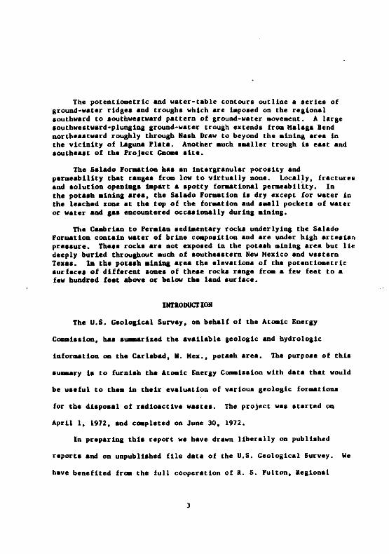
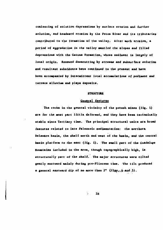
The pota.h aine. of southeaatern New Mexico are in eaatern Eddy
County and westernmost Lea County. Most of the min•• lie alana a
north-trendina 11ne 15 a11es east of the c1ty of Carlsbad and
25-45 .iles north of the Texa. border (fil. 1). Two .ines are 10 a1les
farther east.
The area is sparsely populated. Population. given here are
est~tes for Jan. I, 1972 (Rand McNally and Co., 1972). Eddy County
bas a population of 39,800 and Lea County 48,800. Otber tban Carlsbad
(20,500), the only cities of 1,000 or laraer population within 50 .11e.
of the alnes are Hobba (25,800), Arteata (10,300), Lovington (8,900),
Eunice (2,600), Jal (2,600), and Lovina (1,200). Except for Widely
acattered ranch and fara houaes. the only habitationa within 20 ailea
4

Dl:1lUT• .,. OF TIC~WtTUl IT.,," ....O'C., -..vn
~~~~It ~~ fr~H '1
6
H~ PIL • r'i?l ~H
'\j, Ifo-:, I
-e_.
~O"'''GTOW "l...17--
~"I\'U'H'r. ''r''0
_.'
---"Ifti'-1 l:,
'"
Fi,,,,,, 1.- M,,, 'I the ..,~""t, of ttl, (IOtt,ll ...."U, _t",nt,," ..,.....'cou.s. Geol..ical I • ....., Nort",," """'c1••, III 0,,,••,, ...i" it ,.follO'''' A.. f Et~OI'Of!IO'lI'"d DurIO' f.,"'.1 CoP'''" ...1.
OPDl nu I.I:POIT ArtO 0' hq... ,... 0III10"1I'Cl ey "DC"""II.Thit .... it ".1Ullnar, af>d hal nO.D••", .~,t.~ or ..,·~ ....c lOT ~orlforal."
W1th ~o10.1c&l S",n,y n,o.....' ... or
of the .ines are in Carlsbad, Lovina. and the $IUAll communitles of
Kala.a, Otis, Loco "iI18, and Maljamar. Population 1s hiahly dependent
on the petroleu. and pota8~ industries, and any large tncreale other
than throuah possible expanlion of these indu.tries se~s ~prob.ble.
Surface water
The Pecos River, which rise. In northeastern New Mexico and
ult~tely Joina the Rio Grande at the Mexican border, i. the oaly
throulh-Iolng perenaial stre.. in thi. area. Here and farther .outh
the Pecos receives al.olt all the aurface discharae and at lea.t the
greater part of the aubaurface diacharle from the area. Surface draioale
frca moat of the are& 1a poor. The only .ignificant continuously
flowlna tributary of ehe Pecoa ia Black River, aouth of Carlsbad. The
abundant ...11 lnter.ittent atre"a lenerally draio into depre.alona
produced by aand dunes or by solutloo subaidence where the water
evaporatea or alnka into the aubaurface. Of the later.tteent atrea..,
the 10DIest II tn Monu-ent Draw, which drains aouthward aloO& the e.stern
eda. of Lea Couney. It i_ rare for auch &ene~.lly dry channels to ca~ry
continuous flows of water, as the runoff from thuDder ahowera ordinarily
aioka iota depreasiona in the floor.
The Pecos River, a.. l1 reservoirs behind ewo da.. between Carlabad
and Lovina. and a a..11 part of Salt Lake. ea.t of Lovina. are the only
6

bodiea of perennial .urface water within 14 mile. of any potash _ine.
The northern edge of Salt Lake i. 4 mile. aouthwe.t of the International
Hineral and Cheaical Corp. _ine. Other lak.. (or "lagunaa") ean of
t.he Peco. cant.atn vat.e.r oa.ly after heavy ralna. 1..&"e6 "'ctU.nan aDd
Avalon and the ...llar reaervoir on the rivar at the .aat edge of
CArllbad are l~ alle. or .ore tra. tbe neareat alne.
Topoaraphy
The topography of tb. area (fia. 1) falll ea.ily into four larae
dlvlaiooa: the .uUra. Guadalupe Kounta1a.a and lta foothUb. the
Ulab Plata.a, Llolated atea. of low bille, principelly .outh of Carl.bad
and louthven of !.unlca; and. videlpraad ped1aent. and alluvial plalnl,
nortb, ea.t. aDd loutbea.t of Carl.bad. Collaple featurea locally
.041fy the copolr.phy tbroulbout tbe tealon.
GdAdalupe Houa.tain•• --Tbe Guadalupe Hountainl fora a moderately
di••ected plateau, aent1y inclined to the northealt (Heye., 1964).
South of Carl.bad the aountatna are bOUnded abruptly on the louthealt
by the aeet E.car,.ent. the face of In exb~ed Per_iln reef that bordere«
the Delaware b•• in. Thl••triking ~opoaraphic aad .tratiaraphic
featureeaerge. fra. the .ub.urface near Carl.bad. It bec~a ateeper
and hiaher loutbw••tward from Carl.bad and cul_inate. in Guadalupe Peak
(8.751 f••t). SO ailea fro. the city. Northwalt of carllbad. the
7

aarain of the lRountaina 18 far leea spectacular; the northeastern sl(
there descends atadually to the pedt-ents that flank the Pecos River.
Hiah Plalna.--The Hiah Plalna are a latge rem08nt of the deposit
surface on top of the Pliocene O.allala 'or..tion. The surface of tt
plalna ts re.arkably even and slopes east-south.aat about IS feet pel
.1Ie. It Is underlsiD by • thick layer of caliche, which is ..ntled
in place. by thin .011. West of Hobbs and Lovlaaton, the plain. are
sharply bounded by a southvest-fac~ ero.i0081 scarp, 100-300 f.et
high, known a. "e.calero Rid.e. South of HObba, tbe boundary i. onlJ
vaauely defined (Nicholaon and Clebach, 1961).
Low hl1ll.--The Gypsu. Hills, • Iroup of low rounded hill. erode
fro. Iyp.iferoua Per.lad rock., occupy .uch of the area between ehe f
liver aDd the a.ef EscarplRent, 20 .ile. south of Carlsbad. rartber
north, , ..II hilla locally project above the pied.ont surfacea flank1
the e.carpment. In Lea County, tvo low rldgea, porth and vest of Saa
Sbaon Sink ..y preaerve outlyina re~nta of the Hiah Plains surface
(Mlcbol.on and Cleb.cb. 1961).
Pe4~ents and alluvial plaina.--Over .ost of the ar.a shown on
fiaure I, the around aurfac. ha. low r.lief and .lop.a aently
(20-40 feet per mile) avay fro. the borders of the Guadalupe Hou~talnl
and the Hiah Plalna toward tbe Pecos River or locally toward Black ai,
and Monument Draw. Included, in Beneral, t. all the l.rae area ••• t ,
8

the Pecol Rivet aDd louth and welt of the High Plainl. the area near
Art.lia fra. tbe rlver welt to tbe foothill, of the Guadalupe Hount.in••
and tbe ate. aoutb of Carllbad between the Pecot River. the GypI~
Hilll, aDd tbe leef Ilcarp.ent.
The but<=. fona of _ll1Olt aU tM &round aur-face of the rellon 11.
erOlloDel and c0081ltl ot 'lel.tocene ped~entl aad partl,l pedl..ntl
that have been ~lfi.d to varylDl de.re... Hearly all tbe lurflce
e,.t of tb. 'eco, Ilver, lncludlaa tb. viciDtty of the ,ot••h .iDea,
1, a pedt.eDt or atOUp of coal8.ced pedt-entl of probable early
'.81ltoce08 a.e ~r..n aDd Sayr., 1942. p. 35). Thl. lurtlce v••
aodlfied dur1aa aad line. ttl for..tion by lolutton-collapae feature••
It baa be.~ di••acted locally by Itr......Dd larse part. of it are
"Dtled by abiltin, or Itabillaed ••nd dun'l.
A10aa tb. Pecol al~er and V.lt of tb. rtver. the .urtlce tl youaaer
tbl. tblt to the ••• t and COO8t.CI of a eo-plex of three terrlcel that
c~ly riae like broad low ItepI Ira. tbe rlver to tbe footbill. or
to tb•••clr,..ot of tb_ Guadalupe Hount.idA (Fiedler end Mye. 1932.
p. 10-12). The upper two terrae._ ar. interpreted I. remnantl of
'lel'toc.oe p.d~nt. (Harbera, 1949, p. 412, Mor.an aad Sayre. 1942,
p. 3S). wherea. tbe lowe_t .ad youns•• t terrace wa, produced by
_04orate .ntr.nc~nt of the river aad It...jar tributerl•• lnto
narrow dl.continuoua alluvi.l pl.in••
9
Collapse featurea.--Collapse features produced by subsurface
solution are varyingly common throughout the region. They are moat
abundant east of the Pecoa River in parts of the wideapread old
pedi.ent. Solution occurs where unsaturated circulating ground water
pas.ea through or along the contacta of layera of aalt, gypsum,
anhydrite, or, to lesa extent, carbonate rock. Theae aoluble rocka
predominate in the Late Permian Ochoan Series, whicb uDderliea all the
area eaat of tbe Pecoa River.
Tbe collapae features range in size fro. ..all alnkl to depreaaiona
many .11es long. Indeed, the present courae of the Pecos River waa
probably dete~ined by a train of coaleaced Plel.tocene alnka captured
by a.headward-working tributary of the Rio Grande (Horgan and Sayre,
1942, p. 37). Other conspicuoua expresaions of ground-water solution
include the aubaidence of tbe floor beneath the alluviu- of the
ao.well-Artesia ba.in to a. much aa 140 feet below the bedrock outlet of
the ba.in south of Arteaia ~organ aDd Sayre, 1942, p. 37), the aeveral
abrupt change. in flow in the Pecoa River within 20 .ile. north of
Carl.bad (Hor.an and Sayre, 1942, p. 37), Ha.h Draw and Clayton .aain
clo•• to the potaab .ines eaat of Carlabad,and Sao Si.on Sink .outhwest
of Eunice.
10
Cl~te
The cl~te of nearly the whole region ia le.ia~id. The ave~aae
annual precipltatiQO ranae. frc. about 12 to 13 inche. n.ar the Peeo.
liver and Jal to al.o.t 16 inchel at Kobbl. 10 the Guadalupe
Mouatalna, precipitation rl.e. to about 22 inche. near the a~it.
HOlt precipitatlOD i. from local tbuoderahowe~. that occur fraa
June to October. Tb. variation in tb. yearly total i. larae.
Th. relative bu.ldity In the rea ton II low. Winter. are .11d
with little aGOV, and .u..erl are wlr.. The averaae July temperature
near Carllbad il a little over SO- r. Wlnd.to~a, ..inly In the
aprloa of tbe year, ..y be leve~••
Iadu.try
Hlneral production in Eddy and Le. Count Ie. h•• beea nationally
li.ailieaat, Ind, •• of 1961, Lea County raaked {irlt in the State
In valul of productioa. The petroleua, .a., and pota.h Induatrlea
have dominated tb_ Icona.le. of the two count Ie. for leveral decadel.
All yearly production value••Iven belOW are abltracted or derived
fra. data ca.piled by Stotll.eyer (1~9).
Production value. of crude petroleoa, natural la., natural-.a,
liquid., and oatuzil 'l.ol1ae totaled $12.4 million in 1961 In Eddy
County. Of thi., $54.8 ml1l10n wa. crude pet~oleu.. In Lea County,
11

the production value of crude petroleu. alone, larsely fro- the central
and louthern parta of the county. wa. $247 million in 1961.
The production 11 Iradually iDerealina. Exploration il active and
la particularly Ipurred by increa.loa de..nd for Datural .al. Sanser
aDd Saulta (1971. p. 1039). in dllcuallnl exploratioa tn 1910 La tb_
dlltrict of Welt Texaa aDd .a.tern Mew Hexico, Itated that the
Delaware baaln. u•••8tUI In tbe early .taael of ita exploratory
hiatory. contloued to be very active aDd to have the are.teat potential ••.
Deep S•• re.erve. fro. Devonian tbrouah Ordovician (Ellenburaer)
continue to be of prille cOD.ideration. 1f
The pot.ah .1ne. e••t of Carllbad are the principal .auree of
potalb available within tbe United Statel aDd coaatttute all of the
production in Mew Hexieo. The total value of pota.h produced liace
1932 i. $1.75 billion. In 1966. the value wa, well over $100 .111ioo
(StOt.I..yer. 1969). SLnce then. foreilD co-petitiOD haa Br.atly
reduced production. and aome .ine. are clo••d. Decline in tbe tDdu.try
re.ulted In reductlOD in the population of Carl.bad fra. 25.500 in 1960
to an elt,-&ted 20.S00 in 1912 (Rand HcHally and Co., 1972). Lar••
ce.ervea of potaah re.-in, and the futuce of th. induatry ••••1 to
depend on de"nd, whtch t. influenced Breatly by the exteat of foret,D
co-petition.
Aariculture over ~.t of tbia dry region conaiata ao1ely of the
arazioa of cattle and aheep. Irricated far.a conceotrMled along the
Pecoa liver aear Art••ia and aouth of Carlabad account for a larse
part of the total aarieultural income. There i. dry farm ina on the
HI'" Plain••
Touriat dollara are ao important part of the local economy.
CArl,bad Caverna. White Sanda. and other nearby natural featurea draw
..ny thou.aad. to the area each year.
Accea,
The vicinity of tbe pota.h ain•• ia readily acce.aible by hishway.
railroad freiaht. aDd aeheduled air ,ervice. Th. ainea are aerved by
hard-aurfae. State or federal hiabwaya that provide ea.y year-round
acee,. fru. Carl.bad. r.deral hiahway. extend fra. Carl.bad tn
aeveral direetioaa. Spur 11ne. of the Santa Fe Railroad .erv. the .ines.
eoaneetiaa via Carl.bad with the ..in line at Clovi•• N. Hex •• about
180 .ile. to tbe northe•• t. Carl.bad baa .cheduled air .ervice to
£1 Pa.o. Albuquerque. and Dallae-Pt. Worth via Texa. International
Air Un•••
STRATlGIIAPHY
The polaab ainea in eoutheaatern Hew Hexico (flg. 1) are In an
area of great atratiaraphic 81gnlficance. Sedimentary dep081ta ranging
13

ia aae from Ordovician to Quaternary attain total thickne.aea exceeding
20,000 feet. The area includes the northern end of the Delaware baain,
a Late Permian depo,ttional trouah with Pennaylvanian aDd earlier Peraian
antecedenta. The edge ,of the baa in ia comaonly defined aa tbe front of
tbe laraely buried capitan aeef. Aa auch a. 13,000 feet of Peraian
strata wa. deposited within the area of tbe baa in, which conatltutel the
m08t complete aucceasion of the Per.ian in North A.erica. The oldeat
rocks exposed in the area are of Late Peraian aae, but drillina baa
prOVided abundant infor..tioo on atill older rocka.
The text that followa i. largely limited to brief diacus,ions of
aedimentary environmenta, a£oss thicknessea, relationa between
atratiaraphic uolta, and occurrencea of petroleum. Lithologic deacriptiOGI
and thicknesses of individual unitl are ebown on the accoapany10a
illuetratl~.
Precambrian basement
The depth of the Precambrian ba.e.ent ranaee frc. as little a.
1,000-8,000 feet below the lurface in the northweetern corner of the
area and easternmost Lea County to more than 20,000 feet in eoutheromost
Lea County. Drill data fro. scattered localitie. indicate tbat the
baaemeat consist. of granitic, meta••dimentary, ..tavolcaoic, and
volcanic rocks (Plawn, 1954 and 1956. p. 25-29; Hayes, 1964, p. 5.
Poster and Stipp, 1961, p. 11. 19-29). The Precambrian rocke are
14

generally overlain by Ordovician atrata that lapped northv•• tward
oato • poaitive area io northern New Mexico and Colorado. Locally.
near the ea. tern boundary of Lea County. late Paleozoic uplift
eauaed eroalon of .ll older 'aleozoic rocka. and Permlan atrata lie
directly on b.....nt.
Pre-Per_ian Paleosoic depoaition
'ra. Ordovician throuah Pennsylvanian t'-e...rln~ s.dlments
accu.ulated slowly but falrl, continuously 10 tbe louthea.tern corner
of New Mexico. DepO.ition waa io .nd ..esinal to broad. nearly flat.
subsidins b.sina tbat were northarD ar.s of the Ouachita trough. Thi.
troush passed tbrouab Oklaha.a and central and trana-Peeoa Texa. and
Connected with open aea in the Vicinity of the preaent Bulf coaat or
the coast of aouthern California. In Early Penn.ylvanian tt.e. the
initial rise of a .edian rid•• that wa. to be known a. the central ba.in
plat for. of Pe~lan t'-e (fil. 1) divided an earlier very wide ba.in
Into the anceatral Delaware ba.ln and the Midland ba.in farther ea.t.
The varioua Paleozoic bastna were are.a of eapecially active sub.idence
whoae aurfacea were lenarally lower than thoae on the more atable
ahelves. platfoc.•• or archea boundtna them. Total depoaltion waa
thickeat in the central part of the Delaware basin where lubsid_nee w.a
Ire.teat. but tbe depoaita of 50me tbae lnte~~.la. notably the
Pennaylvanian Period, were thicke.t on the ..rsin••
15
The total thickne88 of the pre-Per_ian .ed~eotary rock. i8
5,000-5,500 feet io the L8mediate vicinity of the pota8h _ine8. The
rock. thicken 8outhea.tward to ~re than 1.000 feet in .outhern
Lea County and thin northwe.tw.rd to about 3,300 feet ne.r the .iddl.
of the northerD edge of' Eddy County. Th. rock••re predo.inantly
.h.le .nd carbon.te. (fig. 2). locka of Ki••1•• ippiaD and
'eno.ylvanl.n .ae are dOMinaRtly .hale in the central part. of the ba.ina
of depo.ition and carbonat•• alooa tb••dg... Kiddl. Ordovician .nd
Low.r Penn.ylv.niao .and.tooe. a few bundr.d feet thick occur in the
vicinity of tbe pota.h .in•• and the Gnome .it••
locka of Ordovician, Silurian-Devonian, and P.DA.ylvanian aae
for. ~port.nt petrol.u. r •••rvolr. ben.ath the centr.l b•• in pl.tfor_
and the Dorthwe.t .helf (fig. 1). Production fro. rock. of the.e ag••
In the northern Delaw.re ba.in 1. widely .catter.d and inter••t i.
incre•• ing in deep exploratory drilling there.
Per_ian depo8ition
Wolfcampian, Leonardian••nd Gu.d.lufi.n Serie•• --Over • l.ra••re.
in the general vicinity of Carl.bad, the total thickn••• of the
Wolfcampian, Leonardi.n, .nd Guadalupt.n Serie. i. 8,000-9,000 feet.
Th••ection thin8 gradu.lly northw.rd fra. the _ine.. The rock8 .re
noted for remarkably coaplex l.teral change. in facie••
16

the aubaldence that deUned tbe &nc.att:al Delawue b••1n in
Penn.ylvaaian t~ accelerated in Early Permian Wolfca.pian tie. and
continued .t a bllb r.te throulh G~dalupian tLDe. Durina .uch of
thi. interval, the baein ext.adea • few tena of .11ea aorthweat of
th_ late Guadalupiaa l~lt. defined by the Capitan reef of that ale.
The aubaidiRa ba.in w.a coveted to v.ryinl depth. by mariae wat~r and
received depoait. of abal., fiae-arataed .aadatone, and dark-colored
It..alooe. Tb. rock colu.a for tbi. lnterv.l (fi,. 2) i. reprelentatlve
of tb. type of d.p08ltlon ln tbe northern part of the b••in. LiCbt-colored
_hallow-water c.rbonate. lenarally bounded tbe baain OQ tbe _helve. to
tbe ...eat and north, and tbe platfot. to the ea.t. Reef. or bank_ of
Ie•• cobe.ive .kelat.l ..tari.l very cam.only coapoaed the baaiavard
adae. of tha.e c.tboDat•• (fta. ]), and aub..rlna talu. for.ed ateep
&lope. 4e.cead11ll to tM floor of the baaln. A. tbe reef. ar.... up....rd,
aa.e _lao arew ba.inw.rd, ovarridinl tbeir talu••
Cloee beb1Dd the reefa and baata, the conte.poraneou, abelf rocka
(f1a. 3) conaiat of bedded dol0.1t., .ubordlnate -.ounta of l~e.tonet
ahale, and .andaton., and locally a little anhydrite. The aradational
contact betweea .belf aDd re.f faciea, .11ke that between reef and ba.in
facle., c~only tranaecta baddina a. it rises in the ••ctlon
~.ainw.rd. rarther back of tbe reef., the dolo-ite of the upp.r part of
the Cuadalupian Serie. (the Artesia Croup) and, to ....cb l ••a extent.
that of tbe lower Cuadalupian and Leonardian Serie. tenda to aive way
lRCr••atnaly to anhydrite. formed in ahallow evaporative Isaoon8.
17
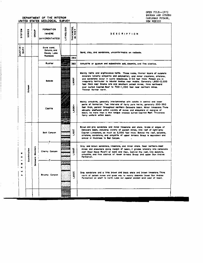
DEPARTMENT OF THE INTERIORUNITED STATES GEOLOGICAl.. SURVEY
OPEN FILE--1972BROKAW AND OTHERSCARLSBAD POtASH.NEW MEXICO
:I..................i.....
..~..
DIFFERENTIATED)
.;...........z ...,,~
u-z%...DESCRIPTION
Sond, clO" ond ••nellto"., "ntonf.r""'I, Oft r,dbtdl.
Gray IOndlton. and a littll brown and block tholl and brown limt.ton•. Thintnorth of I)OtIl.h ,",n•• and gi",., .0)1 to mainly dolomit. tlo••r Son Andr'.Formation) on ",.If to norlh. Lop, OUI 090inlt ancient arch •••, of bo.In.
Anllydrif. or OYP'~ ond lUiordino•• 101t, dOioMit., ond fIn. cl.ttiel.
Brown and groy .ond.ton, and minor IIm..lon, and '''01,. Grad' at 'dO" ofollowor, bolin, lndudlnt ,Icinlty 0' pota." min", Into rttf of Uo"t-aroyCOlllton Llm,.ton" O. much 0' 2,000 f,ot thick. Bohind til, reef, dolomlto,.i1tstono, ,ond.tono, and onhydrlto 0' uppor Artllio Group I. lQui,ol,n' and,imilor in th,ckn... to lell C4nyOft.
Gray and bro.ft IOnd.ton" limllton" and minor .1'101'. N'or nOft".r"_,,,"tmin.. and I'''.'',r, Olonl martin 0' botin, it Iradll laterally Into corbonot,r..' (Goat Step "I,f) or bank and tl'l,n, b,"ind t", r..', Into dolomitl,anllydrlt" and fin, ela.he, 0' law,r Art..ia Group and upplr Son Andr..Formatton.
Mainly "oUt, ond .9I11oCIOU. halite. n,.. rock., thin",r lay.,. 0' ."lotIO.,",in,rolt IChltfly anhydrlt. ond ,eM)lIIOIltt), ond minor cloy.tO"" ,U'''OIII,and lond,tonl occur in ,)'clle "QUlnn., 2-30 tnt 'flle•. ~••h on inirf'qulorl, 1,,,'Iculor to tabular "odl,. ",or middle. Gln,rOlly 1,'00-2,000'tt' '''iell. nla' Gno"'. ,itt ond 'ou'h,r" pof.,,, min,.; 'flint nor'''w.rdo"tr burltd Coptt. "tt' to 100- I, ZOO fnt ntor northtrn ",In...Thlnnor forthor nCN'th.
Mainly anhydrite, ;enorally Intorlo",inGted wltll colelto In control and lo.orports of· f"mo,lon. TWO In"'"ol, 0' fairly pur, halito, ;on,rolly 200- :5!l0'Nt t!'liek, ptr,i,t throut"out norttl«n O,lowor, tla,in. Minar tim"tont. Tnin,abruptly ,,,tt'waN .ith'n "icinlty fit ,"in" and ,I.t""r, at ,"CUainl ofbo'ln; no more tI'ton a "'11ft tOft." era.... burl.d Copitoft IlIHf. TIliellno..fairly unl'or," wlthlft bo.ln.
.,o~
••o!!!
•8..
2.0
310
:".". "'. ::." .:
C.,tll,
Salado
Ruttl'r
Dun. lanct,Gatuna, GndO,••y loll,R,.It'.1
Chlrry Con,.ft
arultty Con,on
I---r--
c.!~•;;~
••..'"z
z..
IZ ...... z.....~zo
u.s. c..ol.,lcel s"u.,OI'U nu ."..,.
nl. III...n.ll_ I••rell.I....' 110•..... ..It" ., .......-. '.r c.., , wl.1o0.-1...".1 '''PI'' .c....,..., _1"lOre.
.....,.t"__ ~
~- ..-.- .........'"1'. _ ...._ .... lIN. Il1o."',........._. It••_d'*-0.. ,01•••••M .....11
~.. _101" ""
-"
...t ....
~ ......
........"0<....,...
---, --=--=
......'---_J_-1-__",__.:;',' .....
.........'''''••o.
_....... ,.
-'-'
-._."",.....-.1
'NOI_ "'.~ ,,"O.'IlIG locnloN Of llfll Ofc_. UtTI(lN IIn'TI"1 TO ~O'''" IIlNUl.l
"
.-
,," j··> •,-•~ I--&;:
I.-••~ •~.- ••
~
,r._ Iii'0
,..- ~-J
.1g-......I~L~---..J
"It".l-· li.fM,.li Ic uGH ..UI.. ,,_ IIOlIlh til no"h 'h'ollth 'h. "cuUI, 01 lilt a- "I. 0114 1l1li,.,"" ""..... £u-, ..... \.n <:co.m,".,.... "'..I~o
19

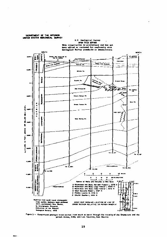
The reefa bounding the northern edge of the Delaware baain
prolrea.ed fro. a p051tlon north of the pre.ent pota5h _lnea. In
Leonardian and early Guadalupian t~e. to a po&1tioo within the .lnl~
area in late Cuadalup1an t~e (fia. 3). Ela.where on the .araina of
tbe baain there waa a a~11ar baa inward proareaalon. At the end of
Guadalupian ttme. the Capitan aeef al.o8t caapletely encircled tbe
baain. reatrictina aouthern acceaa to the aea and a.ttina the ata.e
for ba.lnal evaporite depolition.
The Dorthweat ahelf. Dorth of the Delawara b.ain. and the ~eDtr.
b.ain platfor_••aat of the b.ain. have been (.portant producera of
petroleu. fraa Per.ian rocka. Extenaive paola in a.ndatOGe and
carbonatea of the Arteaia Group and the Sao Andrea 'or..tlon are
cQGcentrated ln • belt ~ed1ately above aad behind the buried Capltl
Reef. but there baa been aianlfieant production fr~ al.oat all partl
of the Wolfcaapian. Leonardian. and Cuadalupian laction in varioua a:
OD tbe abelf and p1at£or.. E.tabll.hed pool. wltbtD the nortbero
Delaware baain are .ore scatterad and are principally in landaton•• I
the Delaware Mountain Group.
Ochoan Seri•• o·-The floor of the Delaware ba.in i••arly Oehoar
time 1. leoer.lly e.ttm.ted to have been .t lea.t 1~200 f.et below I
top of the Capitan aeef~ which a1.oat encircled It. While ..ny
hundred. of feet of Ca.tile For..tion evaporitea .cc~l.ted in the
20

basin, .ppa~ently little accumulated in the reef and back-reef area,.
P~obably rather late in Ca.tile t'-e, the b•• in wa. filled to the extent
that a thin tonaue of aDbydrita estended locally acro•• the bound ina
reef .nd onto tbe .belf. The uppermo.t part of the C•• tile
iotertonau., re.tv.rd into b••al halite of the S.l.do For•• tion (Jone••
1954, p. 108-109. Jooe. and Had.en. 1968. pl. 2).
The Salado Formation i. one of tbe principal depo.1t. of haltte
on the North Aaerica. continent. It overlie. the C•• tile cooforaably
io tbe Del,waTa ba.ln aDd axtend, over tbe C.p1tan aeef to tbe no~tb
and ea.t, far beyond the I~it. of the area bere de.cribed. Whether
the Salado once exteuded we.t of the ba.in i. unknown. The Salado
.e. wa., in leneral,even .ore ••1iRe th.n the ••a of Ca.lile t~e.
Lackina ••hield of c.rboDAte reefl, it received, however, conaider.ble
ftne cla.tic .edt.ent. It. halite depo.lt. are aener.lly Ie•• pura
than tbo•• of the Ca.til••
After wide.pr••d depoaiti~ of the Sal.do .alt. the .ea water
fre.hened .a.evbat, and anhydrite a•• in daain.ted depo.ition durin.
lustIer t~. (table 1). The au.tler 'or.-tion i. very largely
coextea.lve with the Salado In thia ~re.. In the .ubaurface of the
northern Delaw.re ba.ln .Dd of the .helf to the north. the Ru.tler
'ppear. to be confor.abl. to the S.I.do (Jone., 1954, p. 110; 1960.
p. 12), fra. which It I. commonly .eparated by • layer of .0lution
breccia. dl.cu••ed later In this report.
21
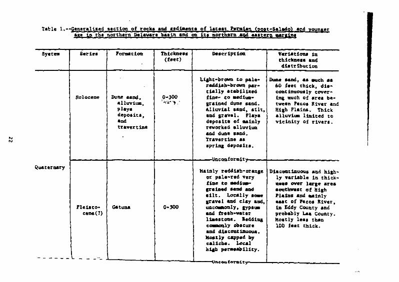
tal:le 1.--GeneraI1z.!1 uct10n of rock. aad ,eola.nta of lateat Pende,. (pon-Salado) and younaerIse in the faorthern Delaware ba.:in and on 1u norther! and. ...tern !!rlin.
'"'"
SYltem Ser1e.
Holocene
'ot1IlI.tiOft
Dune •••,alluvium.play.depolit.,aDdtravertb.
Thieme••(feee)
0-300,,,,--..~.,
LLaht-browu to paleredcU.ab-larown partially .tabil1Zedfine.. .(;0 aediUl1grained dUlie .and..Alluvial und••11t,and Iravel. Playadepo.ltl of ..101yreworked alluviumand dUDe .aDd.Travert1De II
.pr1A& d.poa1tl.
Vartatiou 1athiem.'1 and.4:Latrlbutl00
DuDe aand... auch a.60 feet thick. diecoat1nuoully cover1n& tlUeh of area between Pecoa River andHi,h Plains. ThickaUuv:Lum liJdted. toVicinity of river,.
!- -f -f +__uQ,cQD.forllllty-__+- _Quaurut>y
Ple1ltoc.... (7)
0-300
Mainly reclcUlb-oranleor pale-red. veryfiDe to eecli..grataed .alld. andaUt. Loc:&lly.caecravel ADd cla,. aDd.UDc~ly. ayplWD
&Dei fre.h-vaterU •••tooe. le4ell.ca.aonly oD.cureaDd dlacDlLt1lwoua.Kon17 cappe4 h7caliche. Localhilh ,......11i<7.
DlaeODt1Duou.l a1:14 h1&h"1)' var1&ble in thlek..Qe.. ""'111' lerse are..outbve.t of HighPla1D. and. Minty.&It of Pecos RiveT.1D. Eddy County andprobably Laa County.MOltly leal thanlOD feet thick.
-- L _.L--------JL-----L__..,'O'CODfO'r1Dity-__.L _

T.hJ~ J.-.Ceft.r.J1.~~ ••:tlon of roek. aad ••d~rt. of latelt PerataD (po.t-Salado) arA younger••e 1" the northern Del.vlre ba.1n and on it. norther& and .a.tern ..reinl--Continued
Synelll Setie. FOl'1Dl. t too 1'htckDe.a Delcrtpttoo Variations in(foet) thlckD... and
diltrlbution
Chiefly white, ,ray. UDderlle. Bilb PlainlaDd r.ddtlh-brova aDd ~cb of Lea Countyf:llle-Craiud ..Dei. farther .outh. Pro-¥bleb locolly boa bably ab••nt from Eddy
Tertiary Pliocene O.a11ala O-Joo calcite c_.nt. County except forSubord1Date Iravel. north.a.t corner •• Ut. ad clay.Lenticular. dt.con-t:llluoul be4d.:lIlI.KalDly capped vltbcalicbe. Hlablyperaaeable.
Ilconfot1ai....
&eedilh-brown ad Thick••t 1n ... terncr.en1.b-aray clay- L~a County; ero.ion-• tOIle aDd lubor- ally thinned welt-
Triassic Upperdiaate amountI of ward to wedge out
Chinle(?) 0-1,200 reddi.b-brown lilt- near ea. tern edle ofTr1."1e ItODe and fiDe- iddy County.
Irained land.tODe.Soee .ecozuiarySYPlum. Low per-aeabUity •
-~~.- ._-----

Table l.--Generallzed ,eetlen of roee. and .edt-ent. of lateat Permian (po.t-Salado) and yoUftlerale in the northern Delaw.re b•• in Ad on ltl nortb.rn .Dd e•• tern _rglna--COIltinu.d
5y.tn. Serie. Foru.tlon Thlemen De.crlptlon V.r1aUoa..- in(foet) thlckD.••••Dd
dlltrtbutloo
Mainly p.le-reddl.h- AbIent Dear .nd weltbrown. pale-r.d of Peeol River .ndand ar.y flne- to loeally f.rtber e.&t.HcUuaa-ar·1Iledea-only cro••-
Trl... le Upper S'Dt. Ro,a 0-300 .tr.t1fted ..1Id-Tria••le .tone. Lenae. of
pebble conglo.er-.t•• Local thinl.yer. of red4i.h-brovu lilt.tOlleand clay.tone.R1ah local pera.-bUlty.
conforalt.1
"eddl,b-oranle to Hoinly 200-300 feetrecici:1.b-brown fiDe- thick in vicinity ofIr.1ned ..ad.tODe. GDOlIe .ite and pot-.ilt.tooe, azul uh ain•• ; loc.lly.bale. , Sa••tone ab.ent. Th1lll Ira-
Perlllun Ochoan Devey Lake 0-400 aDd .llt.tODe .re aually northward.R.dbed. c~ly clayey. Ab.ent we.t of Pecol
Thin l_batlon "iv.r.and ...l1-.ea1ecroat l..laatione~OD. Pe~-
bi11ty I'Der.llylow.

N
'"
Table 1. __ C.n~all.ed ••ctlon pf rock. and ••d1.ent. of latest Peratan (po.~-S.l.do) aed younserau 1n the northern Del.vare b•• ln and on in luxtber& and e••targ Mrl1ge--ContiAued
Syetelll Serlee rOr.a~iOD ThiekD.••• De.criptlon Variatlone in(feet) thiem••e aDd
cU.. tributiOD
MOitly aabydrlto. TIl1Do very aro<luallyCou:l.derable ..It, DOrtbvard. TIllck-ea-.aaly .ilty or Del. ranae. fromclayey, occurr1q: 200 to )00 f.et in1D cCDtral part of vicinity of GDOIH:Delaware M.iD ad lite and .iD•• duetend. to lena out to var1able .ub-
Permian Oeboan RUltler 0-500 at ..raiu. Tvo .urfaee .olution.dolomite layer., a whieh bereu.1b..al .aDd.tone. ve.tvard.aDd leveral th:l.lmerlayer. of fineela.tie. are wide-.pread. Ilalnaquifer 111 CarllbadarM.
•The IUltler reprelenta the 1•• t Permian .allne aea and tbe upper
layer of • remarkAble .equeDce of pr.d~Laantly evaporite rock of Ochoaa
aae. the entlre lequence 11 I' .uch al 3.500 feet thick in the northefD
part of the bl,in. the thicknell drop. rapidly to about 1,500 feet on
tbe ahelf near th_ northern pataab _in•• aa4 deere•••• aore aradually
tarther north.
After the aea withdrew. tb. Devey Lake Redbed. were a.pollted on
DeMO audflau over tb_ fOl'8llr I.a bad. Tbe appearaace of ..dtua-n'II,
cro•• l ..1Dat 10n 1n ••ndy leu•• 10 tbe upper part of tb. fC)I:,.. t 10Q
probably indicate•• aradual chanae to fluvial coadltLonl (Vine, 1963,
p. 23) .1 tbe final epiaode in the lana ca.pllx hiatory of the 'er.l••
depositlon.
Except for dolo-lte aDd I.ndltone layerl in the l~.tler 'ar.-tlOG,
the Dehoan Se~tel senerally hal yery low per.eabtltty. The little 011
produced fro- lower Ochoan evaporite. apparently ••eaped fro.
UIIderlyLIII t.nct.tOlle (Ad.... 1965. p. 2148).
Tri!•• tc .ad Cretaceou. depo.tti09
fluvial depolttloQ r ••u.e4 1ft Latl Trl•••te ti... wben thl Santa
Roaa Sand.tone and the fiaer araiaed redbed. of lb' Cbiale(l) 'or..tl~
for_d on flood plaln. 1n , very l,rae are, over and beyoud the
border. of the Delaware b••in. The Jur•••ie Period i, Dot r.pre"Dte~
by dopo.ttion in Cbi. reaLoo and va•• t~. of aro.tonal fe_oval of
Trl•••le roeka we.t of the ba.ln.
Late 1n Early Cretaceoua t~e, a 5b.ll~ 5ea advanced from tbe
loutb and covered .outhea.tern New Mexico. It aoon witbdrew leavinl
behind a thin depoalt of l'-eatone and aandatone. Tbe only remnant.
of thil depolit in the vicinity of the northern Delaware ba.1n are
in very ...11 araa. in aa.tera.o.t Lea County, in tbe weatern GYPlua
Hill., aad pa[hap. on the cre.t of the ~eef £Icarp.ent (Hayea, 1964.
p. 38).
T.rtifr! and Quaternary depolition
No a.rly or .1ddla Tertiary dapolltl are known to be prelent In
the re.lon. CratacaOUI depolltioa wa. followed by brold uplift 10
the vicinity of tbe Guadalupe Mouotll~ and farther nortb and by
erollon of Crataeeoul &ad Triallie rock. to for. a lurflee of low
relief Ilop1na .aatly ...t .nd louth••• t. In Pltoeena ti.e, thil
.urfac. eataoded fro. .ear or wlth~ the pr••aut Guadalupe Kountal.
are. and fra. tbe uplandl aortb of that are. louthe.ltward into Texal.
It wa....tlad by tba fluvial O••lliia ror..tion. whale upper .urf.c.
of depolltioo i. fairly well pre••rved 00 tbe Klab Pilin. today.
There are DO defiaite r....at. of tbe O.allall weat of ea.tera.olt
Eddy County, but ,rIve11 la the P'COI valley and on bl.h partl of tb,
Guadalupe Mounteloa bava been iaterpreted a. belonalDI to thil
lor..tloo (Breta and Borbarl, 1949).
Halt author. believe tbat the Pecol valley w.. for..d in
~uat.rnary t~. after O.all.l& depolltloo. Solution ,ub.idenee. the
2)
coalelcinl of solution depres.lons by surface eroslon snd furtner
solution, and headward erosioD by the feeos giver aQd its tributaries
contributed to the formation of the valley. After .ucb erosion, a
period of Illrldatloo in the valley ..ntled the alopel and filled
depresslona with the aatuna 'or..tlon. whos••edt-ent 1. laraely of
local o~illn. Reaewed dowacuttina by Itrea.. and .~bs~rfac. solution
and relultant .ubl1dence have cont lnued to the pre.ent .ad bave
been acco-papled by loteralttaat local accuaulat10aa of pedt..nt aad
terrace alluvlu- and pIa,. depo.it ••
&Tl.uctUllll
General feature.
The rocke in the .Ineral vicinity of the pota.b _loee (f1a. 1)
are for the .Olt part little deformed. and they have been teetontcally
.table Ilnee Tertiary t~e. The prtoelp.l Itructural unit. ara broad
feature. related to late raleazoic .ed~ntltiOD: tbe northern
Delawlre balin. the shelf north and welt of the b.llo. and tbe centrll
ba.in platfo~ to tbe e•• t (fla. 1). The ...11 part of the Guadalupe
Houatalna included in tbe arel. [houah topoaraphlcllly blah. ia
.tructurally pert of tbe ebelf. The "Jor atructure. war. tilted
Bently eastward ..inly d~r1n& pre·Plloeene t~e. The tilt produced
••eneral •••tward dip of DO aor.·thaa 2- 'fl.'r~~'~4·').
28

ii
::•
_._ ..... -_--..._.
;I~# }~t:-~------
~~~-"2
::-:-:"
~t:; IT -i----
"J;7
/. 'I
I (r, /i)r!'\<
:! Jj.)~'_, I [j-j-'
I-j'":i !."7::"~ Ii
-'-~-I",.1..:1-
'~-""---~''".''.J.L';"';"''::''''',: -, i';"f~-'-
:::-.;:::."';."::.:.~:.;::
Delaware basin
the Delaware basin w•• fir.t defined 10 larly 'e.naylvaolan t~.
vbe. co earlier very broad b•• in wa. divided by ialtial uplift of a
lara...diaD ridg, that b,ca.a the central ba.lo plat fora of Perala.
ti... Tb. baa!••ubatded relattve to tbe bouadla. plat for_ aad
Ihalf until Lata Per.iao t~e, when It. hiltory •• ao active atructurl
feature eaded.
tb. fo~ of tbe oorthern part of tbe b•• lo, a. def1Qed by
contoura on the aurface of tbe Prec-.brian floor ('oater aDd Stipp,
1961), i. a broad a',..etrie.l trough, trendtna nortb aDd p1uaaiaa
louth. The axil 11 1n central Lea County. roughly parallel to the
central baetn pl.tfo~. Tbe e••tern 810pe of tb. trouCh ri,e. rapidl
to the platfor_, where•• tbe weltern .lope 1. auch leotler.
A. in any aradually .ubI1dln& ba.ln. th_ older .,d'-eot. are
downwarped 10 a fora Uke that of the b••ellent floor, and the warp101
d1e. out upward 1n the ba.in .actlon (fla. 4&). The Late ler.lan
Ocboa. cocta .Dd tbe Tria.aic roeke expo.ed in the b•• in today do nol
reflect b.llawtde warplol, aad tbe1r ..jor .tructural f••tur. II the
re.tOQ&.l .aatward alope ••ntlGned above. Thh alope b 15-100 feet
pec _lIe to prox~1ty to the Goome a1te a04 tbe louthaco pota.h _toe
Dlaruptlon of the re810Dal alope of tbe Ochoao aDd YOUQ&er rock
ia .laor. The v~ciOity of the Goa.. aite .ad the aoucbecn _ioea i.
30
apparently repre.entatlve In Itl Icatterlng of open foldl, do.el, and
-..11 fault., which ..y ba, In part, of tectonic orialn. Deep-Ieated
fault. witb .ore than 20 feat of vertical displacement .re r.re if
not abient there (Jone., 1960, p. 16). Near the weatern edge of tbe
b•• ln .nd tba pre.ent upper cour.e of the Black River, CeooKoic
tectonil...y ba tDvolved in a northwelt·trendina .anoclinal flexure.
Kelley (1911, pl. 5) Ihowed 600 teet of relief acro•• thil .onocline
00 the upper lurtace of the Bell Canyon 'ormation. Sever.l ainor
hiah·anale faultl cuttiaa the Ca.tile Poraation in tbe .... p.rt of
tbe ba.in and two taterred faultl at tbe northwe.tern edae of the
balin (Kelley, 1911, p. 48·51) are aOlt probably product. of .olutioo
lublidance. Sub.urfaee .olutton h•• produced ..ny otber atoor fault •
• nd nuaerou. local fl.xure. in the near-.urfaca rock., a. well a. tb•
..ny aiokl and laraer depre.liona. In addition, ...11 lurficial
dome. that are attributed to differential .olution of .alt or to
expanlion of .nhydrite durina hydration are nuaerou. (Vine, 1960).
The lenerally .baple .urtace .tructure of tbe ba.in il doubtl.a.
loaewhat deceptive. A fault aone to tbe Guad.lupe Hountaina ..y bave
extended .outhealtvard tato the we,tern edle of the ba.in, below
tbe yaunaee .onocli~ delcrlbed above, and ..y h.ye beeo actiYe during
"i••l •• lpplaD to Early Peralan t~e (Hayea, 1964, p. 42). Penn.ylyaDlan
deformation, for whlcb there 1. wlde.pread evidence In ea.tern Hew
31

Mexico and western Texa., may be represented elsewhere in the subsurfac~
aDd rapid Early Per.ian aublideoC8 of the buin wali accompanied by
wide.pread block taultin, within it (Ad.... 1965. p. 2144).
North....eu lihelf
The regional atructural 810pe 10 that part of tb. ahelf nortb
and west of the Delaware b•• ln (fl&. 1) 1••••uch •• 200 feet
per ..11a 10 tbe Guadalupe Mountain••Dd .aDerally no .ore than
100 teet farther ea.t. In the vicinity of the northern pota.h _lae.,
tbtl 810pe 1& interrupted locally by .inor d~., fold•••onoclinal
flexure•• and faults s~llar to structural features described Dear
the aouthern .1ne.. A difference here I, that .oa_ of the da..a are
probably of depositi~l oriS10. c.eultin, fro. irrelulariti.e 10
Guadaluplaa carbonate depo.itlon (Hott., 1912), Mawhere, here or
near the southern ..In.s. are there, "atroDI or well-defined zones of
foldinl or iaultlna repreaentlog r.apona. to ca.pre••ive or tenalooal
forcea" (Jon.a and Hadsen, 1968, p. 9).
BeyoDd the vicinity of the alaea, the ahelf north of the baain
includes a few more atronaly expr••sed atructural feature••
Several .il•• north....est of Arteaia. a burled northeast-teendina fault.
offsetting Upper Per_lan rocks alon& a dlatance of about )0 .iles p I.
probably part of • promlnent let of northeast~trendln&shear zones th.t
extends far to the north. Hove.ent on these &ones was luitiated In
Carbonlferou. or earlier time and ..y have been bastcally rtaht
32
lateral (~elley. 1911. p. 44-48). Another buried member of tnt. let
..y pa.s ~diately southeast of Lake HdKillan (Roswell Geolo,icsl
Society. 1968. f1a. 9). A lORa low ea't-trendins arch in Late Per_ian
rock. the &tteat.·V.cuua .tch, p•••e•• little south of Arte.la. It
i. at lea.t lara'1, th. product of differ.ntial compaction over the
Abo aeef of E.rly Per.tau .ae.
In the p.rt of tbe Guadalupe Koatai"a included in the .r••
di.cu•••d• .ooociln•• aad tolds ar. the prominent .tructure.. A
buri.d broad fold or arcb of L.ooardian .ad early Guedalupian age
tread. Dorth••at • little b.hind the pre.ent ae~f &&car~nt (Kay•••
1964. p. 42-43). It .pparently controlled the location of arowth
of the Goat Se.p and Capitan I ••f.. Much later. probably durid&
Tertiary tille, .oBocllaaL flex-lna, cOlltrlbuted. to tbe b•• i"....rd d1p.
in the Lat. lar.t.n cocke of the ••car,.eot. Other fold•• 00 the
ridae abO¥. tbe ••car,..ot and a1.0 about 12 .tl.s weat of Carlabad.
are of early tertiary or perhaps oldar ......
Otb.r thaa .100r .urficial d.for.ation related to solution aDd
hydration of evaporite•• the enttre ahelf in tht. area appeara to have
been atable 1.n. Quaternary tw.
Centr.l ba.in piatfor.
Th. central ~a.ln platfor_, who.e western adse i. included in
the ar.a dt.cus••d here. ha. an eventful ht.tory lnvolv1na ~re
int.nee defor..tton th.n that of the b••1n .nd .helf..
In latest Mississippian or Early Pennsylvanian time. the area
wa. defor.ed to an elevated e.eraent fold belt. trendlna north-northwest.
Tb. belt ..y bave been bounded by'blah-anale fault. and ..y bave a
horst structure (Ad.... 1965. p. 2143). After .ub-eraence and
deposltloo In MIddle and part of Late PeDllSylvaniao twe. renewed
oroseny furtber elevated the area and "aharpened. co.pr••••d. and
faulted tbe fold. 1I (HUla. 1963. p. 1711-1118). Uplift continue.
atroaa1y throuah Wolfcaaplan tt.e aDd then .lowed. SInce filii.. of
the Mi,Uaad and Delaware baain. 10 Late 'eralao. tille. tbe plat for. bat
been atructurally .table.
GEOLOGY or SALT DEI'OSlTS-·OCIIOoUI SEIDS
All tbe .alt depo.it. 10. tbe Carl.bad potaab area are In the
Ocboan Seri.. of Lat. Per.lan ase. The Ochaan coo. lit. entirely of
••d'-antary rock., but It baa twO diatlnct parta--a thick lower aectloa
of .alt-bearina evaporlt•• aDd a thin upper aection of red bed.. The
low.r .ectlQo loclude., in a.ceadlna order, the caatlle. Salado. and
Ru.tler for-.ttooa, where•• tbe upper aection conatata eatirely of
tb. Dewey ~ka aedbeda. The ca.tlla 'oraatlon 1. coaflned to tbe
Dalaware ba'in 10 tha .outhero balf of the potaah ar.a .nd 1. known
DDly In tbe sub.urface (U... ItA). The thr•• youDler for..tlou for_
tha pra-quaternary bedrock across tbe Ir.at.at p.rt of tbe ar••
34

(fil. 4) and'. althouah they are larlely covered by extenlive dune
a.nd. caliche. and alluvial depoaita. they are well known fre. tbe
count Ie•• borehole. drilled in exploration for pota•• iu. lalCI and
petroleu••
IxpOlure. of Ochoen evaporite. la the pocaah area are exceedla&ly
poor for .crat1&raphlc .cudlel or any other lave't11ltlonl requiring
preci,e knovled.e of ch. ca.polltloa. ledimeaCary Itruceure,. or
thickne.1 of th. tbr•• evaporite for..tloOl. Thi' II true bec.uae of
the conalderable lithic aDd aeructural chana.1 that bave acca.paaled
extenaive evaporite .olutlon and re-oval by ••teoric wacerl. Solution
of balic. aad other readily loluble lalt. hal beea coaplet. to depth.
of leveral buadred feet, aad all anhydrite and other loluble calcium
••lta ha.,e been " ••tb.red to .ypau.. The re.oval of aoluble ,.ltl
baa r.aulced io a areat reduction of formation thicknel.e. and 10
auch .ub.ideace aad accoapanyiag brecciltlon of all realdual IYP'~
and overlytaa depo.lta. Coolequently. the entire area of e.,aporlte
outcrop 11 ia reaUty a " re• oUch" liberaUy dented aad crealed by
Duaeroua linkl, fi.lurel, and linear lolutton valleya.
Caltile For..clon
The lower pare of tbe Ochoaa Serlel i. repre.ented in the Carlabad
pota.b area by the Ca.tile For..tlon. The C.ltlle wa. aaaed and
..... ', .):)
defined by RichardiOn (1904. p. 43) to include aeveral hundred feet of
'YPIU. that overliel the Bell Canyon 'or..tlon and underliel the
RUltler ror.ation at the lurface io tbe vel tern part of the Delaware
ba.in. Somewhat later. the loterval reprelented by IYP.u. at the
.urface v•• found by drililna to con.ilt of a much lar.er .e,uence of
evaporite. 10 the .ublurface. including .altly anbydrite in the lover
p.rtl of tbe evaporite lequence and .oltly rock lalt in tbe upper
part. ror. t'-e the two part. of the eveporite lequeoce were cl•••ed
.a lower aoO upper ••mbera of tbe Caltile. but they were con.idered
to be leparate for..tionl. 'inally. Laoa (193) reltricted tbe aa.e
ca. tile to the lower part of tb••equence and applled the na.. Salado
to the upper part. le.ionally. the criterion mOlt co.-only uled to
differentiate one for..tlon from the other ia the predo-inanee of
anhydrite io tb. Ca.til. and tbe predo-inane. of halite 1D tbe Salado.
The Ca.tlle For..tlon underlie. tbe loutbern bllf of the potaah
are. at depthl ranatna fro. about 500 feet in tb. velt to al.olt
3.200 feet in tb. ea.t. The nearelt outcropl of the formation ere in
the GYPIU. Hilll in louthern Eddy County. N. Mex •• about 16.ilel
loutbvelt of the pota.h ar... In th.t area the C.ltile conalltl of
ioterlaminated vhite ,yplu. and dark-brovniah-gray 1~lton. and
10" la.lnated brownl.h-aray I1meltone .nd • little brown doloaite.
Hear tbe center of the Gyplu. Hll11 the for..tion dipI beneatb the
S.lado 'or.-tion and IYplua aive. way to anhydrite ln tbe lublurf.ce.
36

In the lub'urf.ce of the Carl,bad pot.,b .re., the Ca.tile
For..tion il readily divi.ibla lnto tbre. iafor..l .edherl. The
tripartita lubdivi.ioa include•• lower and .n upper .nhydrite ••.ber
.ep.r.ted by , thick ••It ..-bet (fla. 44). The three ••.ber••r.
di.tinctiv., .re contor"'le, aDd con.titut. l.ter.lly perlII tent
rock uoit. 1D the pot.ah .re••ad over wide lectiona of cb. Del.ware
ba.la. ."1' the urala. of the b••ID., however, tht thret -.lIbtrl
..rae into ••iaal. vada.l1k..... of .n~ydrite th.t r.pidly thin.
to • narrow tODlue and extead••cro•• the b•• in ..raid for. few .ile.
before thiuaiaa out 1D tb••outh'l'n part of tb. northve.t .helf.
D. lowar anhydrlt. -.b.r of tbe CanUe 'or..tloD arad.tl00ally
overli•• th••ell Canyon lor..tiOD in tbe Delaware ba.in, but
overl.p. the Capito L"'ttoQ.••lana the ..raR of the b••ia. Within
tbe '1''' of overlap .. the lower .-bel' of tb. ca.tU.... pre.~ to
di. out abruptly, In part by piacbout 'I.ln.t tb. C.pitan L~.tOQ' and
ia part by l.t.r.l .radation into la-ioated 1~.tOD' that ar.d•• ia
tura lata ....iv. 1....tOD. of tb. Capit.n. Tbe ..-b.r r.Dae. in
tbie-knell be. 210 to 230 feet 1n the .outh.J:n patta of th. pot.,ll
'1'.', but thickeD' northward and att.in. thickne••e. of 320-380 feet
••bort di.tance fro. tb. overlap of the Capit.n L'-e.tone. The
pred0ll.1nant rock 10. the ...ber i. loterl_ioated Itay anhydrite aod
~rownl.b-.r.y It-e.ton.. A f.w b.d. of dark-aray and brownl.h-aray
It.••tone, • few tach•• to .ever.1 feet thick, are per.i.teat tn the
lower .nd .iddle p.rtl of the .ember; .~e are practtcally of ba.tnwtde
ext.nt ..
31
The .iddl••embe~ of the C.atile 'ormation ia a .alt·rich lentil
tbat for•• a wid••pread, 11tholoSIcally d1.tinct atrat1&rapb1c ..rker.
Th....bar 1. 550·100 feet thick In the louthern part of the Carl.bad
pot••b ar.a, but th1ck.n. northw.rd aDd Ittaina tbickne'I.' of
800-1,000 feet alonS a broad 2- to )-.il.-w14. baIt tbat parall.ll tb
_raln of tbe Del.ar. ba.m. Mortb of tbi. balt, tba .....r
ter.toatea, 1n part by l.t.ral Iredatlon to aDbydrlt. and 1. part
by lotartoaautn& with aDbydrite (f1,. 4&). Tb• ..-bar i. pr.daaiDant
rock .alt. but it coatatn. tbin to thick layer. of tDt.rlaalaatad
aabydrite-U...toae: r'oek. The tb!cltelt of the•• 1ay.rl ayera,e. abou
100 t••t, IDd it divid•• the ....r into tvo al.,.t .qually thick
••It bad.. Th. low.r of the two bed. i. fra. of Int.rlaatD&t.d
.nbydrite-l~e.ton. lay.r., wh.r.a. tb. upper b.d include•••varal oj
th••• lay.r., .~ of whicb ar. 2-5 f •• t tbick.
Th. upper .....r of the c..tli. ror_tiOD 11 an aabydrit.-rich
unit that axh1biu tb•••t Utboloaic ca.pl ity. It cou1lU ..lD.]
of lat.rl"loat.d aahydrite.. U•••toae; but iv. anhydrite aDd rod
..It ara pr•••nt In appre~lable -.ovate and there ar. l ••••r -.ounC.
of dol_tt. aDd .,neelte. Th....ber Ulclud..e • Dortbval'd-thinniDS
tonaua of "Ioe.itic anhydrite that overl.p. the C.pit.... L1aeetoae
aloaa tbe .araia of the Oelawar. ba.in and extenda • few .il•• into
the Dortbw.et .belf (fta. 4A). The _1D body of tb.....er Je
38
700~800 feet thick in the .outhern part of the potash area. bot thins
northward and i. a. little as lSO-300 feet thick in the area. near
the margin of the Delaware basin where the underlying .alt member i.
thickelt.
The ea.tile Por.-tion i. overlain by the S.lado Formation. The
contact between the two for.-tiona hal been con8idered to be an
aocular unconfo~ity (Ad... , 1944, p. 1608). Contrary to this
interpretation, .ub.uriae••tudiea in the earl.bad potaah area and
elaewhere in the Delaware baein ahow that the upper bede of the eaatile
Irade laterally into, and lPtertoogue with, the lower beda of the
Salado. In this trau.itlooal .equeDce, the Caatile iDtertonsu.a with
e~ccee.ively older rock. of the Salado, cau.ing a aradual etratlgraphlc
de.cent 10 tbe top of the ca.tile, which i. re.pona1ble for tbe deer••••
in tbe thickne•• of the upper .e.ber of tbe ca.tile fra. about 800 teet
in the .outhern part of tbe pot.eh ar.a to about 150 feet and Ie.. in
the central part of the area and then to 0 10 tbe northern part.
Salado 'o['...t100
Conaiderable econoalc 'igniflcanc~ ia attached to the Salado
'or.-tlon becaua. it contalna the potaah depoaita for which the
earlabad area ia well known ..ong geologists. The deposits are the
da.1nant source of the potea.ium .a1ta mined 1n the United Statea,
and their wide extent aussoata that they will maintain this ['anking
39
for yeara to come. Depo5ita containing aylvite (KCl)--the ..In
pota.aiga aioeral of econa.ic ~portance--havebeen .loed at
11 loealitiea (fi&. I), but they underlie practically the entire
eaatern balf of the potaah area and extend .aatward beneath auch of
louthveatern Lea County, N. Hex. (fi&. 6). Tbe Salado alao contalna
..ny depoaltl rlch ln polyballte [K2Ca2"&(So4)4·ZHzO] that are
extenllve and widely diatrlbuted but lack tbe ecoao.lc '-Portance
of tb. aylvitic depolitl. The polybalitic aDd Iylvitic depolita ara
fairly '-portaDt ala.enta 1D tbe atratiaraphy of tba Salado 'or..tlOD,
and a epacial lectloa of tbie raport (appendix.) eu..ari.a. Ia.e
detail. of tbelr 4iatrlbutlon and leololY.
Tbe Salado lor.-tiOD, ....4 by Lana (193S), il tbe old.lt
unit 1D the OCbOlR Serlea that crop. out in tbe Carllbad potaab araa.
The ..to expoaurea of the for..tloD ara near Lake Avalon, north of
carlabad, N. Mex. Here the Salado ovarliea tb. Tanalll 10raatlOD
and underlie. tb. auatler 'o~tlon, but tbe Itrat1&raphic ralationa
caaaot be deteraioed poaltively fra. ax..laatlon of the outcrop.
The Saledo appear. to overlie tb. Tanalll 'or..tloR cODfo~ly and
to arade upward Into tbe auatler 'Dr..tlon. The lower part of the
Salado arad.a laterally .outbwer4 into the upper pert of tbe caltlte
'or..tIOD. Tbe sradatlonal CORtact betveen tbe Salado and tbe
40

--- ..----_.
~. -.-.==:::.:..-:.......;
"-=-:=~:::::.: :'=;:::.::."::"0:::::- - _ ..
1lB--
, ,

Ca.tile riae. in atratigraphic position fra. north to 50uth and ia
depicted .chematically on the leologte atructure a.ctioaa (fta. 4A)
Eaat of the outcrop, the S.lado For..tlon underlies the centr.
part of tbe pota.h area at deptb. of 2S0 e 100 feet. In &eneral, tb
depth to tbe Salado locr.a••a witb diatance fra. tbe outcrop. aDd
it t. a• .uch •• 1.600 feet at the Dorth.a.t corner of the area aD
about 1,000 feet at the aouthea.t coraer.
The Salado For-ation 1. characterized by thick persi.tant uni
of rock .alt alternatial with thinner unit. of anhydrite and
polybalita (fia. 1). Thin ..... of claystoQe UDderli_ virtually
all the anhydrite and polyhaltte unita, and there are a few thiD
bed. of .andatone and siltatone at lana lntervala. All the aahyd
unit. and bed. of cl.stic rocka are dtatlnctlve ..~era that .erv
al atratlaraphic ..rkar badl; two are for..lly na.ed rock unit••
The wideapread Cowdeq Anhydrite ~ember, Q&_.d for the Morth Cowde;
ollfield In Ector County. Tex. (Gieaey aQd 'ulk, 1941), lie.
90-200 feet above the Ca'tlle 'o~tion. The Vaca Trllta Saodate
of Ad... (1944) near the .iddle of the Salado 'or..tloD 1a a
quartz- and clay·rlch unit of fr....nt.l rocka contr•• tina .harp;
vlth adjacent bed. of cryet.lllae ~vaporite rocke.
In expo.urea of the Salado 'oraatloD aloaa the ve't ,1d. of
carl,bad pota'h area. all the .alt ha. bean r • .eved by aolution 4
42
the anhydrite and polyhalite have been altered to IYps~. The
alteration of the evaportte rocks extends to depths rang1nl fr~
260 feet to al.oat 1,600 feet below the aurface and ls responaible
for a fourfold to aixfold reduction in the thickness of that part of
the Salado and for a chanae in ca.positioo from dominantly rock aalt
io the subsurface to d~inantly IYpSU. in the outcrop. The contact
between the two biahly dis.~ilar parta of tbe for.-tion. known
locally a. the "b... of leacbed &On811 and a180 as tbe lOtop of aalt."
i. hiahly irreaular. with ..ny clo.ed depra•• ion. and iaolated
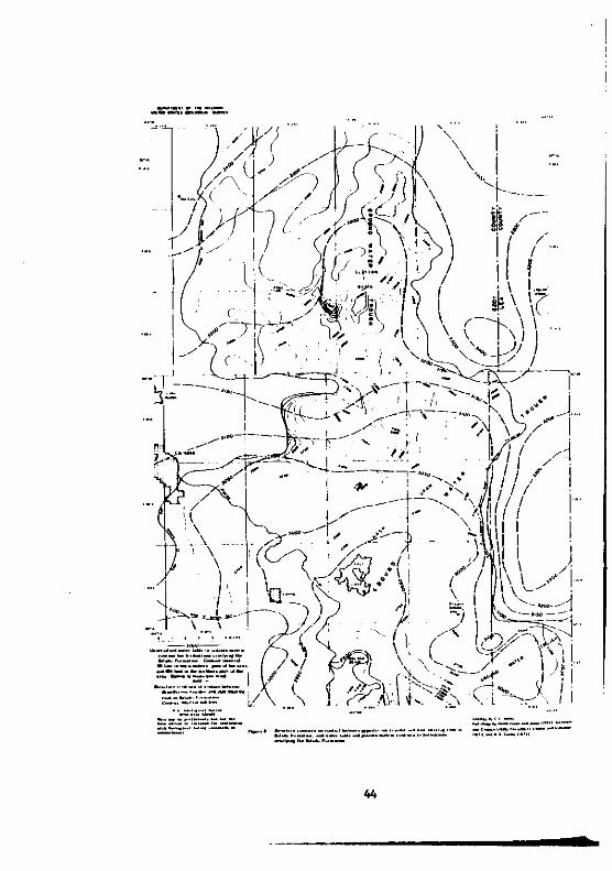
pinnacle. (fta. 8). The contact dips lenerally ea.tward but riaes in
atratiarapbic poaitl00 fra. lhe base of the Salado near the west
atde of tbe potaab area to the top of the (oraation near the
Eddy-Lea County line at the e.st .lde of tbe area. The altitude of
the contact renaes fra. a blah of sliahtly .are then 3.200 feet near
the northweat corner of the area to a low of sliahtly leaa than
I,SOO feet at the south edae of tbe area.
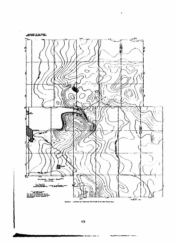
The ...Lau. thickne.s of the Salado Formation in the pota.h
area ia ali.btly .ore than 2,000 feet 1n a northweatward-treodinl
&ooe tbat parallel. tbe ..rain of the Delaware b.ain at the Eddy-Lea
County line (f1a. 9). The thickne•• of the Salado decreeses slowly
.outhward within the ba.in. but d~ini.he. rather rapidly no~thw.rd
and westward fr~ the zooe of .axi.u. thickne.s. The northward
43
-_ _..'-_ ---_.
44
_....---_.
~
.....u. ,_••••__..'~... "' ..._""'........
..._------,-_.._-

reduction i. part of a broad pattern of re,ional chanae 1n tbickne••
at or near the aouth edge of the no~thweet ahelf .~.a, vbe~e_a the
weatwatd reduction i& rei_ted la~lely, if not entirely. to e~apo~it.
aolutton and removal by .~teo~ic waterl. Within the ahelf atea.
local reductiona tn [bickne•• a~e aharp over pre-Salado knoll.
or "hLgha ll at the Getty. '.arbec. Halfway. and other a..11 oLlfielda
whicb appear a. domal f.aturea on tbe Itrueture "p of .DUtb.a.t.~n
Nev Mexico publiahad by Stipp aad Kalaler (1956).
The Salado Pormation 1, divided ioto tbre. inforaal unite: a
lower •• It .ember. a pota.b·rtcb ~mber. known locally •• tbe
HcNutt pOla.h zone, and an upper ••It .e~er (ftl. 1). The three
ae.ber' are conforeable. are laterally peraiatent rock unita, aDd
are about equally rich in rock aalt. anhydrite, polyhaUte. _an•• itl
and claatie rocke. In fact. they are aenerally .~ilar in vlrtuall)
all but one relpect. The lower and upper .e.ber. are alaoat entire]
free of .ylvtte and other pota•• iua and .Olt "anellua evaportte
aLnerall over auch of the Carl.bad pota.h .rea. whereas the HcNutt
zone i. a.nerally rich in thele .1neral. over .ucb of tbe ar_a and
contain••everal extenaive aylvite-belrins pota.h dopo.ita of leono
i_portanco. Thele depolitl aro th_ obvioua lithololic featute that
.etl tbe McNutt pota.b &one apart fro. the lower and upper __.bara
of the Salado lad .ake. it • fairly natural atratllrlpblc unit. T~
46
depo.its are restricted to a few amall groups of mineralized salt
bede or ore zone. which are .cattered at irregular but fairly short
interval. through partl of the HcNutt zone (fig. 10). Nearly all
the depo.it. in the McNutt zone are mineralogically complex and
contata a hoat of hydroua _inerall that are ther..lly reactive at
fairlY low to .aderate temperatures (table 2).
Ruttier Formation
The Rustler For.-tioR, pa.ed by Richardson (1904). is the
younaeat aalt·bearinl unit in the Ochoan Seriel. The for.-tion is
..inly exposed in inliers scattered irr.gularly through the central
and we. tern parts of the carlsbad potaah area. It Is ove~laln by
tbe Dewey Lake Redbeds. The contact between the two for.attons t.
oblcured in outcropl by Ilu.p1Dg aDd warp ina due to evaporite
hydration, lolution, and removal by meteoric waterl. Fru. sub,urfac.
Itudt.I, however, it appears that the formations are unconformable
at placel near the weatern edse of the Dewey Lake Redbedl. The
discordance and hiatus are not sreat and they diaappear eastward.
Over broad sectiona of the area the Rustler and the Dewey Lake appear
to be conformable.
In the lubsurface below the zone of sround-water penetration,
the RUltler For..tion il .ostly anhydrite and rock .alt (f1a. 11).
47

Table 2.--Evapor1te .inerala in .ylvite aad polyhallte deposita ~ the C.~l&t.d pOkaah are.(Modtft.d from B.rB. 1970)
(H...lt1Dl; !. bol1iD&; Dec. clecOIlpoaitiOD.; Deh. clehyclrat10uj T, transition)
Mineral Poraula ner.1 effece. &Ad temperature ('C)
M B Dec D.h T
Anhy4r1te------.--CaS04 1.193
Apht hit.11t.······[(K. M·)3M.(S04)2) 940 437
Bloed1t.·.········M.~g(S04)2·4R2D 67D 625 110*220*
cernelltt.········EKiC13•6H20 160* 190 230~ 425*CD
Gl.ub.r1~.·--·····Ra2ce(S04)2 944 520·540
He11t.············RaCl 800
X01n1t.···········lMgS04Cl·3H20 490·540 160* 425277*
K1•••rtt••--······K8SQ4·H20 1.124 340
Laagb.1n1t.·······K2K8(S04)3 930
Leon1t••••••• •••••K~g(S04)2·4H20 760 140* 580180*
Loew.1t••••••••···Ral~7(S04)13·lSH20 670 625 220
Maan••ite-------·-MaC03 350
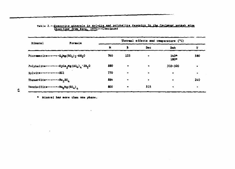
Tabl. 2.·.Evaporlte ,1neral. 1£ .ylvtte apd polyha11t. d'poli\. to she Carltbad pot.ph .r!f(Modified trom .'fl, 1970)·-COftttaued
K1aeral roraulaTbe~l effect. &Ad t..,.ratur. (·C)
II I IMe 1Mb r
Plerooerlte.-•••••IiKICS041206H2o 760 125 - I- 580180*
Polyb.l1te-.-•••••K2C&i"I(S04)4°2~0 880 . . 310·320
Sylv1t.--·········Jtl 770
rbouardlte.-- •••--Ra2S04 884 - . . 240
V.ntbofflt'.-'••-'''"6H1CS04)4 800 . 51S...~
• Hineral ~ _Ot'. t'MoD oae pb....

~, ! , , , 0, ••_.J
., Ii;I, "'_I.I .. -.
~ I"" ~
h~l'0,I
<"~•~
;
~
~
~u
"'0
J j: "i1<.1 ~
Jt '.
"IW~
"~,••0i. -0
i • "~ · u
• • =• • ~
~,
:• ~
i <•
:I~
"•5"
~. h-l':i' ...-. J~l! :t'at,:j"'" 111
.~
Ii 'W' II(i • tIt ~~'" •i !i I '
..GI........~ ·.1...."
~I !~.11Ih!1
It
"! p81 ~m tm lIll~mlolil:• ill ml
:::1, ' .Hi
•

Some polyhalite i. commonly p~e.ent near the middle of the formation.
and thin to thlck unlt. of .aDd.tone~ sllt.tone, and ahale are
inte~bedded at 10Da to short iDte~vala. Dolomite i8 present in the
lower and upper parta of the formatioD and forma di~ttnct .t~atisraphlc
marker beda which have wide and peraiatent development in the pota.h
are~ and other sectioa. of southe•• tern New Mexico. The dolomite
in the lower part of the formation ia known a. the Culebra Dol~ite
Member and that in the upper part a. the Halenta Dole-ite Kember
(Ad_. 1944, p. 1614).
The luatler For..tlon r ••chea a ..x~ thickne.s of about
SOO feet in the ea.tarn part of the pota.h area. The for.ation thins
toward the outcrop in the central part of the area (fia. 12). Here
the fMaatl00 .e'Del'aUy I'allis. tn thlcknu. h_ about 200 feet to
400 fa.t, but itl tbickne.1 variel coneiderably over .hort diltanc•••
The variable thickne•• i. due in areat part to the leachina of •• It
.nd the hydratiOD of aobydrite by .eteoric water.. In leneral, the
remaval of aalt account. for a marked reduction in the thickne•• of
the for.ation, and the hydratlOD of anhydrite re.ulta in an increa.e
of tbickne•• (fia. 11).
Dewey Lake Redbed.
The Dewey Lak. Redbeda, named by raSe and Adama (1940), 1a tbe
yaunaeat unit in the Ocboen Se~1ea. but unlike all other member. of
the OchoaQ it i. entirely free of rock .alt and other evaporite rock••

_...----
The Dewey Lake c0Q61atl entirely of aLit, tone and flne-ar.lned
••ad.tone. and lanerally raDa.' 10 tbickne.. ft~ about 400 feet
to S50 feet. It 1_ expo.ed 10 low bluff. tn the ceotral aad ••• tern
partl of the pota.h .r~. (tia. 4) and 1. uDconfor..bl. with
ovecly1na Tri••,ic rocka.
52

GROUND-WATER HYDROLOGY
Thr•• "in hydrolo&lc unit. control the around-water bydrololY
of tba Carl.bad pat.ah .lninl are•• The•• are; (1) the Pecol Riyer,
wbich receive. the .round-water outflow fro. the project .r•• ; (2) t~
wleer-be.riDI .trata oyerly1na the S.lado For..Clon. and (3) tbe
Capitan L~.toa- aad otber water-be.rina .tratl underlyin. the
Salado ror.atloD. The dlltrlbutloD and devllo,..nt of lar.1 101ut10n
f ••tur•• , particularly 1. the .... '" D." and Clayton salln ar••• )
exert a ..Jor .ffect OP tM occurrence and aove.nt of the &touncl
vatl".
Pee" River
The reco alvar rlc.el.,.....rl, eU the natural clUCMral of
It"ouAd water that .0"' thcou.b eM rock' of the pata.h atniD, ar•••
The princlpal plac•• of DAtur•• around-vater inflow are at Carl'bad,
wbere water .rive. fe_ tt.. capitaa Ll_.t~ diecharae. to the
river or to tM .lluvi.. borderiDI tM dver, .n4 ....r Kal'la Be04
(fl&~ 1), w~r. biahly ~ ...r.ll&.d water i. dl.cbarl.d fro- t~ Ru.tlel
'On.aUOD to tIM river. BetweeD CArl.b.d and Mal.g. Bend the river
rac.lve. w.tar fro. tba alluvlua, .xcapt lu ar••• where Pu-plnl ba.
10Wllred tM water tab I. below river level.
Water-be.riol unit. overl,lDI Salado 'or.-tlon
A ...11 ..oupt of around w.ter occur. In all the I.olo.lc
fon.aUon. OYlirlylnl the S.l.do lor..tlon, but the ..in aquU.r. or
53

water-yielding unitl are the Culebra Dol~ite He.ber and ba.al
.olutton breccia zone of the aUltler FOra&tioR, the Santa kOle Sand. tone,
and t~ alluviu.. Locally, the Gatuna 'or..tion yteld. water to well••
In the area wit of and neu' the Pec08 River, water tn.- the aUu"t.
t. utilized extenaively for irriaation purpo.... E'lt of the river,
in the pota.h aininl are., ooly • few weIll have encountered potable
vater. The yield. of the wella are lep*rally low a04 agat ara u••d
for the weterina of liv.acock. The Cul.bra Dol_ite MIIaber occutl
tbr-OUlhout aueh of eM are. aDd. h tbe ..La. loune of dter tappe4 by
.Cock wella. The ba••l .0luttoD braccia &0" of the a"ltlar .O~t10DI
often referred to al the "brine aquifer," 1a the unlt that ia 80It
I11Difleapt in the lolutton of the hallte in tbe uppal' part of tbe
Salado roc.atlon. tabla 3 '~fiz'l the hydrolo., of tbe .eololle
fo~t1on' overly1nl the Salado For.ation.
Tba fo~tlon- above tbe S.lado '~tloD •••• to be connected
bydrolo.lcally and can b. eoaaldered la eon't1tutln. a lioa1e ..ltipll~
aqUifer .ylte. (flil. 4A, 8). Bow perfectly tbl1 aquifer ayat•• i,
dev.lope4 tl an open que.tlon and cannot be deteraiMd fra. the
exiltina hydrologlc infor.atlon, altboulb tbe levell of water atanding
in weill are .ufltet.ntly unttoe. that potaQti~trtc and watar·tabl.
contourl can b. coo_tructed throughout the area (f1l_ 8). Tb1. water
tabl. and potentia..trlc 'urf.ee rangeI fraa Ie•• than 200 f.et to
about 1J 4oo feet above the contact between the IYpliferoue reaidue and
1.lt-b.aring lock 1n the Salado For..tion (fig_ 13).
54

t
\
t
55
"..,
i, ..Iiij....
IIi...
Solution activity and a••ociated col lap•• , .ubel~nc., aDd fractur·
iDI bay. iocrea.ed tbe oyerall perMabiUty of the rock. and eounced
tba 1o.tarfor.-t1onal aewe.DC of watar 10. the aquif.r .yua.. The
.oluttoo .ett~o in tbe ar•• of tbe pot••b .tnae .1.0 baa "tr1..ota11,
.ffactad tbe cbe.1cal quality of tbe .r"'l1~ vatar.. A~ly.a. of vall
watar iodicat. that the IrO'lM wuar io the aloinl ara. cootaioa
alCh hi....r -.ouota of di..alved aubtta1lCe. C:b&o do.. tbe watar af tM
aurroundina ra.100 of a.v ~xieo; tbia 4tatributional ralation_bip 1a
lDdic~tad beat by·the total di_.alvad aolida (fll. 14) and
cblortdo (tta. 15).
CrQUn4 vater io the far.atiaaa abaye the Salado ro~tlpo .ava_
I.DI:~all1.aoutbward and lout.\t¥eltward acro.. tbe ,ataab uni... area
tOlMrd the PeeGa aivar (ttl. 8). Moat ot the dl.cbarl. of tbe .roued
vatar takaa placa 10 the I'aacb of tM hcOi alvar ••1' Mala.......
Thil ell.charp ta fro. about 8S0 aquara aila. of the .1Dinl 81'••
Dortb of Pl'ojact Gua. atta .Dd fro. at la.et .D ad.dltiooal 400 aquare
.tl.a lylo& to the oortbea.t of the alol01 araa. Altboulb the total
alIQUot of 'I'4UH Witar ell.charalDI to tbe Pecoa aiver ia Ilot kaovD,
fblla and otbel'l (1942, p. 69) aa~"'tad tbat 200 lallou pel' .lAUe.
Aotara. the rival' fro. the baaal .olutlon braccia zone.
~~ potaDti~tr1e .Dd watar-tabia eo.toura outline a ..ria. of
Irou...·vat.r riell•• or blabe .04 troupa or lowa (flB. 8), "bleb are
.....,0.." OD CM ra.10na 1 aouthvan to .outbw.twrd pattaro of aroun4
..at.r IIOva_nt. Alar.. aoutbvaatwar4-plull&101 around-vatar troup
56

57

58
eltteRda bOIl Hal.., ....nd nortne..atvard. rougbly t.hrouab Haan Dt:&w to
the vicioity of LaIUDA Plata. Another .ucb ...ller trouln 1••a.t
louthean of the Project CnOlle liCe and extendl trOD. the 'outheaatero
part of T. 24 S., R. 30 E. e~.t-oorthe.ltward acro" ~. 24 S., R. 31 I.,
to T. 23 S.) k. 32 I. A aouthward-pluoliol trough il in the ar.a of
Clayton ...In. Water ~e. 'outhe.ltward toward tbe clntlr of thta
trwah trOll tta- Dorthweltlro p.ut of the aloina area, louthward fr_
tba portherD border rellooof the .1ninl area, and loutlftte;lt"ard and
weatward fro. • narrow around-watlr ridSI betva'D Clayton Balin and
tapna 'lata. South of Clayton ....In tbe troolb. 1. DOt • vall-d.eU.d.
hydroloaic feature. It.Icb of tbe water in the troulh doe' not .ove
directl, toward tbe '.cae aiver fro. the Clayton sa.io .1'... lplt••d.
tbe watlr 11 divert•• loutb-Ioutbealc"ard throulh the rock. underly-
iUI Quabacla "ielae lilto tbe &roun.cl"..ater troulh in. tbe .alh Dra" .1".(a•• Gatuna .0IWl.tloa. table 3), whar. 1t Joina vater ..wiDS louth-
....tw.rd taward tlw '''COl Rlvlr.
S.lado roraatlon
~ Salado foraatioD haa an int,rlr.oular porOllty ,ad per..abllity
that radl" fro. low to virtually none (Steven. and othera, 1910,
table 1). Locally, fract",',•• an4 .olution ope.a.lns. l ...ct & .potty
foc.atlonal par...blllty. In the potaah alnlnl area, t~ Salado
Po~tlon 1. dry except f9r a..l1 pocketa of water or water and g_a
that hav. beea encountered occ.alonally during .1nlns and t.lt-drl1llDI
operation. and for w.ter pre.ant 1n tb. leacbed zone d.v.lop•• at the
top of the fOnYtiOD. Sa. of the watar and Sa. poclr..u ara conUned
uDdar biab pre••ur.. In .ucb of tb••ioinS ar.a around wat.r aovina
tbrou.ab the ba•• l p.rt of the &".tlar ror..tion ba. fOrMd a laachad
aODe alona the top of tM Salado 'Or.aUOD (fia. 41.). In placa' J the
lalcba4 ZODe axtaQd••ora than 200 faat into the Sala40 'or.ation.
Moat of the di••olvad .olid' io t~ brine in the ba,.1 ,olution aone
of tM Ruat lar 'or.-tion baa baan obtaiDild fr_ the laached &00&.
G. o. "c~o (writtao C~D'J 1912) .'ti..t •• tbat duriol the
pa.t 5 8111100 ,..al" •• .'I.alt ba. baeD di..01.,.d lat.rall,. in tbe
vicinity of Clrl.ba. J Hev MaxieoJ at an avara.e rate of about 1 1/2
to 4 811a, par .111100 )'tIal'.... Tbia coocluaion 1& ba.ad On tba fact
that the dlttaoca fr_ the aa.tarn front of tb. Guadalupe Mountaioa
to the pre••nt weat.rn li~t of ..Jor .alt bad. i' about 18 to 20
.U•• aDd on the followiD, ....,UO'MI (1) the OSalla1e 'orutlon
fOrMrl, axt.nded acrOti. the recOIl KivaI' vall.,. at 1•••t a. tar a. the
front of the Guadalupe HouDtaina J (2) tba PaeN Rivar vallay in tba
vleialt,. of Carlabad baa baen for.ad 'iaea oaalla1a tiM J and (3) the
0&&11111 'orutioQ baa ba.n aroded and the Par.tan .alt di"olvad frma
tbi. area durin. the ,..t S .11110n ".1". It doe. Dot •••• probabla
that •• It axtaoda• .uch fartber ..at than the front of the Guadalupe
Hountalna before oaan,la tlM; if the .alt w. 1••••xt....lv. bafor.
osana1a tl_ thl' aatl..ta 1. eona.rvaUva. tl
60

Strata und~rlYinl Sal'.2 For..tion
The reraiaa. to C&abrian ••elt._ntary rock. vnderlylul the Salado
'o~tlon contain vat'r of bria- coapo.ltion and ara und.r blab
art••ian pr"'ure. ~•• rock. ar. Dot .xpo••d In the pot••b .iolnl
ar•• , but they Ii_ d._ply buried in the .ublurlac' tbrou&hout auch of
'outhe.lt.rn Hew ~xlco and welt.rn T..... ~...1 (1965, fi ••• 1·7)
Ihowed that in tile pat.ab aintna '1'" the .llvation of tha potea'"'
tla..tric 'urfece. of differ.nt aoa-I (axeludinl the Capitan Lt..ltoOl
of tba.. roc.ka 'fa..'. fr_ a fa,. flet to a fft huDclrad f'.t .b~ or
below tbl: laadl lurfac.. At ProJlet Gn.- .ita whera tt. Ivar'.1
IIIVltlon of tbe laad lurlacI 1. about 3,400 f.at, the pot.nti~trle
.urlac•• ara .t .1avatiaa. betwean 3,400 .ad 3,800 faet, which i.
600·1,000 fHe abOVI tbl top' of tbe baUtl iu thl Salado 'MU.tlon.
tI.. d lrectioa of tM .1ope of tha pot.otic.l:tric .urf.caa diff.ra
• .."bat, but it 11 ...raUy to the aa.t or DOrtbea.t tn .outbelatarD
...,. .....1co.
The CApit.u LiMltone and. a..ociltad dolOlll1Uc part of the Ylua
IDd Tloa:Ul 'OI'MUoaa foEW tha topaoat aquifer in the .tratl be.atb
thll S.lldo rorMtioa. Tha•• forutlona crop aut or U. at aballow
depthl loutbwa.t of carllbad, but they II" d••p1y burl.d •••t of the
dty naar the patl.b .ina. (fil. 4.\). The CApitan U"ltoM cOIIpril'.
a li.nt r••f 1-2 ail.1 wida that ...t.nd. Dorthaa.tward _ad ••,twlrd fro.
cael.bad acro., the .inlll& ar•• _ the Yat•• and. Taulh 'O['WlaU,Onli .d.J01l1
61
- - -
tbe north aide of the capitan Ll.e.to~ real, WI.t of th_ Pecol Rival',
the Capitan Li...toae 1. devalopad '1 • IDurel of water fo~ the city of
~.rl.ba. Ind for trela-tion. I.at of tb. ~lv.r only. faw vatlr willa
peDen.ta tbU unit or the ratea and Taoatll rOrMtiona. leat of the
PeCOI Rtvar, water in ebe Capitan U ..UOM and in the Yat•• and
Tanatll 'oc.ationl 1. under ItrobS arta.tao pr"'ura. According to
Balpeany aocl ar••• (1962, tabla 2), tbe potlntlQM;Ulc lurf.c. of
...cu· in tb... unlU h 1arse1y above .tbe 110d lurfec. 1& ebe 11'" ••• t
of tlM heOI Rtvee (fill. 4, 4&). Within In 11". that Ixta._ 14 .U••
•••t-Golrt.....e of carlabad, .... of tbe _tar ta tbe Yata. aad ranlUI
roru;t!Od ..,. .ow upw&['d, .Lx with "atar 1n the Ku_tler J'onuaUoo,
lAd ltd ia tbe .olutton of halite, IYP'~, aod aahydrite tn tb_
IUltlar aad Salado For.atioal. Tbe 4t.tributloo of chloride IbQWD
on Itaure 15 18 cOlJllUtaot w~th the cOflcept tbat uptMrd .aYeM:at of
water doe. t.te pl.ce.
PCII'ASH MINIS
Hi.tory of .ipin.
The pota.h .in" in Ed.d.y and .... tounUa., .~ Hex~, produca
about 84 parcant of the pota•• lua aineral• .toed. in the Unlted. Statel.
Hlnloa activity fa the area be.aa io 1911 after the dilclolura by the
'ada,.l Gov.r~ot 1n 1926 that 1araa tonnas,. of pota••luaw bea,loa
~Plr.11 ware pre••ot io 'eratao Itrata nelr carlabad, H. Mex. '.ak
production w'. re.ched in 1966. The biaher Irade c~rci.1 ora 1n
62

the area ia ne.rial depletion aad aoat of the aeven producing
ca.peaiea have 1••• thaa a IO~year aupply. Large low·sr.de depoait.
re..in, but t~ir recovery ..y not be co.petitive with the Canadien
production. .ecent productlon cutback. reBulted in a reduction of
_-,lo,.-nt that ba•••riouely affected the econoay of the Cerl_bad
eree.
Location ~f .ine.
Nolie of tba potaah .1ae. in eha C8Elabad dhtrlct ha... been u ...elopl
on 48pOllta in • DDrtb·t~.ndin. belt 10·12 .tIe••••t of carl.b.d.
MIM .1.... haYtI been developed a10nl thll trend. Two .ina. ba...e been
opened on c1epotllU 6~8 Idle. fartber .eat, ..ar the Iddy·Lee County
U .. (fl•• 16).
The .i.... ere owMcI and operat.d by t'" Teledyne 'ota.b Co.
Ca .ubeidiery of Continental "'ricen Royalty Co.), 'ota.b COMPany of
A.eriea Ca dlvi810n of Ideal aa.le Ioduatri•• , Inc.), Duv.l Corporation,
Interoatioaal Mlnerale and Che8ical Corporatlon, Soutbwe.t Pota.b
CO. ,C. aub.ldiary of Fr••por~ Sulphur Co.),aRd Kerr-MCGee Che.ical
Corp.
At the pra.ant ti_, el,ht alne. operata in the diltrict (H,•• 4,
16). Tbree aiaea are cto••cI, Willa-Weaver CDuval), Seundera (Duval),
and Lie (Bacloul). The Teteclyne Pou.h No.3 .108 1a uheduled for
clo.ur. in Aucuet 1912.
63

H!thods of prospecting and exploration
All proa,-cUn. and exploraUoD In the dl8trtct b.. been done by
hoi•• drill.d fro. the turface. Ho.t of tbe hole. werl drl1led IDto
the top of the Sala'o by ..a~ of cburn Ot rotary drl11101 I'll" The
bol•• werl co-pllted t~oulb the ora &ODlI witb a 'ia~d drill. Ca.ioa
v•••et ia the uPP'r part of the boll and ca..ntld loto the top of tbe
••It. The c•• log .nd cI.at a••1 prlVllotecl vueI' tr.. the auatllr and
youR.lr rocka Ir_ .ourin. the bola. "ftar tM bDl•• wera c.-pletld
.Dd .-.plld, the ca.lb1 va. pulle. and the holl. plUI..d with c...pt
fra. botta. to top. 10,u.e of the .arlier drl111PI the lawaI' parta of
tM hoi'. ver. plul". with -.d, but thoa. partl .bovl tba top of the
a.le wera flU.4 witb c••ot. It caQ be .a.~d that all Ixploration
boll' drilll4 for poteab kavw balD etfectively ••eled.
!be dloalty aad "diatributlOD of the Ixploratlon and dIV.lo~Dt
'rill1DI ara abowo 00 flaur. 11. to .Ioaral, the pattarn and ••"lty
of drilli.. refllct. the pO'ltloo or the Icono.lc 11.1ta of the pota.b
.apollu. Gutaide thl .eu.ly drill'••1"" tbtl 01'1 bor1&ODII 10 the
Salado ar. probably co.poeld of halite aad only ainor .-ounta of
pota.b.
Hlnlng ..tbocl.
The bedde4 pote.h .epoeitl .1'. aearly flat lylna over larae .r••••
tberefor., .od1fled coal-.lnio& ..tbodl hav. be.o ul.d in a.ttactiPI
the ore. The ore-bearing borJr:ou are reached throuah vertical
64
abafta fra. which ..in entri.e are driven into the ore bod1.a. r.na
of r~ and pillar••re develop.d off the ..In entriea.
The ..io eotrie' are lenerally 1'-20 feet wid. and 8 f.et biah.
Wher. double .otri•• are driv.o, they are epaced 50-55 feet ap.rt.
The bre.ktbrouah. are about 7 feet hiah, 32-34 feet wide, and ere
driv.o 00 100- to ISO-foot c.nterl. the avera.e rpa. liz•••1'.34 x 42 feet. The beiaht of the roa.l, dete1'll1...d by the thick...
of the ore bedl beinl aiDed, rana•• fra. 4-10 f.ee.
Bacb ora body i_ developed to it. econa.ic liait. by the above
Mtbocl. fitl cyc:le of alnlnl b r.ferred to al "flrlt alnlna" Ind
re.ulta 1u au ore recovery of about 50-55 p.rcent.
Secoad. .t:Allll ot flnal alnlna la tbe reaDv.t of ,illaTa and tbe
rene.tilll frca tke outer eda•• of the developed .re. towar4 the ..io
haulal.vay. and lbafe.. Wbeo cbi••id~n& cycle ia ca.pleted, tbe totl
or. recov.ry approad.,.. as-gO percent.
Pinal aininl re.ulta in the re.oval of pillar lupport Ind tb.
eve.tuel lublideac. of the aioed .1'.... aaentry into the caved .r••a
i. aot poaaibl••
!!ill!.T\teoty-Uve ahaftl have bee" I"'nk at the 11tel of the 11 al._ lL
the dt-trict (fia. 4). The .... ft loeatiOnl and otber pertiNDt d.ta
are abowD in tabul.r fo~ on table 4. NODe of the .heftl baa been
ab••doned or deco..l,lloned. Nearly all abaftl are coDer.c. or Iteel

-:•
--:a ~: ="·!i:::.::;-s:.::~"' .... :::;li;.
:
-..~ :i.. -:;.. ............
", ... ",,,,
.. .. II ..........
!;..
.i i
::.::::.::::l:::::::
H••
!...Z...
:;:;i'ii~
~8..;~
"o.
:,. I.~ !::i::in
:ll:SI!=.............~!~!=d~~
~ ~ ..~!~:M,.;~a';';';";
:a;a.;..i.:::::::.::.a::1:::1;:;;:~:e
.....;...; ...:::;;!
~!B~~~!
~!!!nni;:~~~::::::
-00.
~~~s~=
j i 11l)j ~ ~ =ti :u ...... ":
•• ::::=_j• ';';';'a;:Ii;,;,;:>i .::,:,:;::::.
:::: ~~~~:::~21
....~~.~:!.;
.,; ... "' .....
.::,:::::::.:::.:::
U
£ -...............:::iii !
I
.~,,; ..,;,;,;,;
....11:, :. ::a; :;~Vol;;
=:iJi';:';';
;;~~
~~~~~::::::=
:
•a

lined and have atanda~d hoisting and auxiliary equipment capable of
handling large tonnages of mined material. At each ahaft the aquUen
above the Salado Fo~..tion have been sealed with cement I~out, wate~
rinls and au.pa have been conatructed, 8nd pump8 in8talled to handle
water aeepage from the grouted areaa. At ae~eral of the abafta pumping
ta no longer required, and at othera the a.ount of water pumped Is
.1nl...1. The effeclivene•• of the ..thods employed to control the
vater in the abaft are•• 1a evidenced by the f.cl that the recorda show
that no v.ter hai. entaced the .i08 vorkill.8.
Part of the love.ti.ationa for the GnGal8 project abowed that the
Fa~ Che.ical a.aouree. Develop..nt Corp. ahaft in e.atern Eddy County
had been abaDcioned and contained vater. Water-level _aaureMnta were
..de In thia abaft durin. October and Nove.ber 1961 and 1n Deee.ber 1961
after the Go.. device vaa detonated on DeceJaber 10, 1961. At the the
the .a.ure.ota were ..de the vater leve 1 atood at 1,681 f.et be 1011
the aurface or 13 feet above the botto. of the ahaft. Preau.ably the
eource of the vater vae the aquifer in the Ruetler Por..tion. During
the period of inactivity the water had overflowed the au., and collected
1n the .haft. The collar va. coaatructed high enough above ground level
to prevent aurtace vater from draining into the ahaft.
The ahaft baa ainca bean equipped with the uaual ca.ple.ent of
..chinery and ia nov in operating condition. It ia li8ted on table 4
•• Kerr-MCGee Che.ical Corp. No. I.
61
It t. reported that the .baft., with the po.eibla exception of
rel.dyne 'ota.b Co. Mo. I and Mo. 2, ar. 1ft ••cellent condition.
Ixtent of alAe vorkin'l
Porty ,.an of l.r..-t~ul' aLDiDI in tbe ralaU.,.ly tllla-MeWed
ore "po'lt. in the dlltrlet hal r ••ulted in an aataD81va ..sa of uD4er
around vorklns.. Tbe .t.. worldal_ tn U_ flt.trtct cover an ar.e t.
exce•• of 45 .quare all,.. The avara.a balpe of the workiDi' lway
fr~ the vlclDlti.1 of the _baftl .Dd t~ ..1•••tri•• I, about 1 f ••c.
The floor. ami back. are ••ra11, flae 01' ...tly 'loped becau•• the aio
lDJ _tbod. aDd. tba aiDe llyoutl ar. cleli,aed. to follow the o-arl, nat
..11.....1 d1p of tbe bed••
tile _aed ar••• ara in.sular in .bapl! but .o.t ara 810allt. ia
• nortb,·voorc..... t cU.ractloa. Thl1 coafipc'.tloa ranectl tile vartattoG
01 the potaab cODteDt of tM ora bed. aDd &Dt the contialty of tM en'"
cloltal ,.It bed.. In other worde, etwl•• an cha.tcal v.rt.U.o.... 011:'
cbealcal f.cle. within a 11ngla ba., aDd ara DOt vlrtatioDI in the
"It.... l 'atlL_ne.tloa.
Ol'a baa baaD atGi' ft'. four bade or CO...I in tbe Sala.o ' ....tloa.
Tbi lIO.t .xt.... tva: wol'k:illi' ar. in the l...t oC' "'Lrat" ora aone. "hleb
.... betveeu 650 aDd 800 f.et belCN tbe top of the S.laclo. .IM .inae ia
the dtattiet have produc.d ora II''' tbia zone. T.l.d)"lll' Pot.l:_h Co. No. 1
hal produced fl'. tbe "ril'lt" and "Fourtb" or. aOMI. Iutarutional
M1....r.lI a04 Cheaical Cel'p. hi. produce. fru. tbe "'iru," "'ourtb,"
and "FUtb" zone.. Duvalle ...h Dr." .toe ba. produc.d frOll chi "'iIE'U"
68
anel "Tanth" zo...... National pota.h Co. I. Lea mine ancl the kerrwHc:Cae
Cba.ical Corp••1na hava produced frOli the "Tenth" ore zooa. T"
approxi..te .trat1araphlc po.ltlon. of the ore zone. are .hawD in
Ugur. 10.
Stability of aioe work ins.
fba antria., ro... , and. pillara devalopad during the "Uut
cyc la" alnina ara "allned to io.ura atabi lity cc..auurata with .afa
aDd afficiant alniol practica. Back failura ..y occur wbara the back
ia ooly a faw inche. to a foot be low a clay .e... The unllupportad
.alt beel. haYtI a taDdaocy to pull avay frOli the clay bad beca...a of the
loo.a bond betwea.. the tvo rock typa.. Back faU. ara controllad by
the judlciou. aDd .xt.naiv. u.a of bolti"l.
CaviDl and .ub.lelenea
Durlnl float aininl .ut of the pillar .upport h ra.ovlel and tba
vorkadwout araa. Iradually .ub.ida or cava. Nore than 50 parcent of
the a1ned araa. ara DOW caved (UI. 16). In tho.a alne. whera aininl
baa bea.. c~latad, the .ublidenca 1. naarly 100 percant of the
101110. balsht.
In .oet cavad .re•• the ...b.ldancI i. reflectad io tba overly1nl
.urface by the deval~ot of lantla dapre•• ion.. Fracturiol at the
.urfaca io tba .ub.ideoce erea. cannot be accurately ..pped or dater
aloed beeau.e of the cover 'of uneoDlolidated .urficlll ..tar ill.. Soae
fr.cturlDI hal baen noticed in the paved hilh"ly. that crol. the lub·
.ided .r••••
69
--------Althouah detatled Itudle. of the lubeid_nee are•• have Dot been
.0, .....peculaUone concerning t'" _chaDha involved eaR be ..cle.
Subiur-faci oblen-&tion. of ebe lubltdioS ar••' indicate that eM rockl
eberle the _ned I"••' .-v' Blowly dowlN,rd ••• 11.,11 c.ltva block
after flnal aloina il cOIIIplatlcl. J'racturlna., ..11 ace",,, 11'1 eM
a.beLding block, partlcul.~ly in the .ol~lt. bede aboYe the Salldo,
but the pattern 1. Dot knowo.. The unique ,by.ieal pr~r-e-t•• of tbe
.alt probibltl tbe dev.l~nt of open fractur... The frlctur••
for.acl are tllbc or quickly ••• la. by flawa•• or recry.tatIt.,tloa
of tM .alt. The ab'.ACI of vatar •••,... Jnto the mIMI' in ebe ar•••
of 'ub'ldegel 1. indicattva of tbe ••11-••'110& character of thl •• It
kdo.
furelwr avidencl for the cobeltvl"" of the lubllc1epel block it
that allliD, 1. caan'.ntly betDI curia' OJ) iD two at... 11. 01'. bed.
about .so an4 100 fut abDVa the bott.. of tt. cave. block. or ICMtr
aintDI 1."'18. TH ore bed. 1»41101 tined have luff.reel no DoUc.able
Itruetural 4afoc.at1oa other than the .a.. and elevation cbaG... 4ue tel
tu .u"idence.
»0 uta are avanab1. 011 tIM .ffact that .qbllc1eoce baa bid CIl
tbe *",a_nt of watar in the aquifer. above c.be Se1a4o.
Gna.e .haft .~:vorktQI'
The Gno- Itce and ahafe ara ..ar the canter of .ac. 34,
t. %3 S., k. 30 E., Eddy County, M. ~x. (fla. 16). T~ .baft val
10

.unt by the U. S. Atoaie lnerl' Ca.-l•• ion a•• part of the Plow.hare
prolr... Only. brtef _u..ary of the 18010&1 aad da.eriptlon of the
.ioad area. i. liven in thi. report. Detail. ean be obtained fr~
report. on ProJeet GDOM (U. S. Geol. Survey, 1962).
The Gnoae abaft wa••uak to • depth of 1,202 feet. The .baft
1_ circular in plan, ba_ en in.ide dla..ter of 10 feet, aDd i_ lined
with reinforced coocrete to • dapth of 122 feat. It paoetrated about
200 feet of lurficial aDd Plei.tocene depoait. and 1,000 feat of
Pal1li•• rock.. Tbil top of the ••It 1_ about 6~0 feet be low tbe collar
of the .baft. TbI bott_ of the .baft 1a tn .alt about ~SO f.at be low
tbe top of the Salado Po~t1on. Rock. axpoaad in tbe abaft ara .bOWD
on table S. The .hot c~r i. cOPD8cted to the .baft by two parallel
drift••acb approzi..tely 1,100 feat lonl. The drift. and cha.bar are
pear tbe ba•• of tbe upper tbird of the •• It .action. About 1,000 feet
of ....lv••alt i. a.tl..ted to be pra••nt below tbe bottoa of the
.baft and drift.
The Gn....baft wa. ebandoned aDd .ealed by the ABC in Novellber
1968. TbIl d.c~i •• ionin. of tbe .baft wa. done uDdar the lurveillance
of Reynold. Il.etrieal and Inli~erinl Co. and il raported on by Tappan
and Loran. (1969). All ..terial. SivinS a contact radiation do.& rIte
of .ora than 0.1 .illiroents&n. par hour war& reaoyad froa the lurface
aod placad in tbe .baft br flulbed •• a brine .lurry down a drill hole
that inter.ected one of the driftl.
11
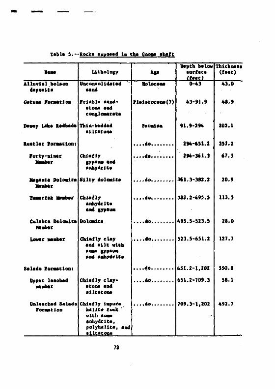
- -
table 5 .. aock. IQO••• 1n the G1l~ lbaft-Do••10 "'1"" Thick....,- Litholol' I.p ~urt:~a (fa..)
t ...Alluvial bot-oD UocQulo114ata' Boloc:... 0-43 43.0
......Ii. •••Gat_ .D~tlOil 'riabl. i ....• 'leh.oca..(J) 43-'1.. 41.'
ItODe a.cOD.I'-Eat.
Do...y IAU a••"'.' Tltla-"'."..._..
91.'.2!t4 202.1liltle..
..attar 'o~tloa, •••• 40•••••••• 2!t4-6U.2 UJ.2
'oI'Cy·.:I.... 'l' Cbl.fly • ••• tlo•••••••• 2!t4-361.3 67.3_r IYp.... aDd
a.,drUa
....D.. DoIDld', .11.y .DI_It. o ••• do•••••••• 361.3-312.2 20.'.._.r_d.t .......r Clollfly • ••• 40•••••••• 312.2-495.' 113.3
laby.rltalad 17P'-
CuI.b.1 DoIDld" Dol.-1te ·...'0........ 495.5-523.5 28.0.._.~. __. CIoI.n, • ley ·...'0........ 523.5-651.2 127.7
• Dd .11. "ltlo.... sypl"..... aaby4l'lta
Salado Wor.atlOQI • ••• 40•••• '•••• 651.2-1,202 SSO.I
U.... I....... Cbllfly .1.y- • ••••0 •••••••• 651.2-70'.3 51.1_r ItOM lad
811t8t..
UDl'.CM' Salado Cblln,. 1_v'C'. - • ••• do•••••••• 709.3-1,202 492.7J'o~tlQa ....Ut. rock'
with .... I....ydrlt.,polybaUtl, alld~iltlt....
7Z
Tbe .baft copClildi cootudaated Mtal .crap, ODe d.-p truck, four'.';'
MM car., a hol.t _n·ca•• , _4 varlou. ather ..t.riale, lnelud:laa I
cODaI_rabl......ot of cont8ll1aac:•••011 aDd .alt .clt.. The report 408'
DOt .Cata hav far up tM .batt tM cootudaat.d ..t.rille .at.ad. OneGa-
t..taat•••011 vel plac.d 10 tlla upper part of th••baft to vltbio S f •• t
of eM .urlac., •• a perMoeat plu. va. laEMd by f111101 c... lau
, f ••t witb coocr.t••
10. ....ltloo.••U _t ••U\ lull....... pl",,0.4 vltb c_at to tlla
top of tlla "lUo•
• baft ... 4<lft. p.oballl1 c.......t be ••f.l1 .04 I.coooalc.ll1 ••belll11••
••••
SolutiO! "pi" estlyit!e.
TIlle laDIal Cit, r.lttDJ Laborator, .... tlla Ur.C of tvo c.,lal••
to cODduct ....r~.C.I .oluC1OD .tal.. proJ.ct. 10 the carl.~' .r.a.
Tbt••zpar~.Cal ,roJ.ct lavolved att..,tl Co •• tabI1.b a caaa-cclaa
"'tva~. two, ltor.hole. Ibout 200 fHt aparc 1. cM W 1/4 '.e. 22,
'1' .. 20 I., I.. 29 &. The ,rojlct va••clrt•• duriul thl lata 1940'. Ind
..........1...be 1950' ••
DurlQ. tbe ..4·1960'. Coati_otal 011 Co. conduct•• la .apar-
...atal .olutio. aiat. proJlct 10 tbl culebad ar•• (IMiv1l .... Shock,
1~70). 'our t.lt bole. Vir. drl11•• 18 tba SV 1/4 '.c. 12, T. I' 8.,
11. 30 I •••boIlt 3 1I~ .n•••••• of .lIa S.....btI... to•••11 Co••bef••
73

The 4rl111QI pattetn vae in the .hape of an equilataral triaDgle
vith a fourth boll 10. the centlr, 200 felt frOll the apex we 11e. The
welle vel', dr111ed to a depth of 1,150 faIt and verI ea.pllt.d in the
"Tbird" ore tone of the Salado 1'0~tiOD. S"beurfaea coooeetiooa b.tVllaQ
velie wera a.t_bli.bed by byJraulle fracturlul froa the cauter or io
Jectioa well.
Ourina the Uti of the experiMnt aD .IUptical caviC, 280 f.at
100.1 and abCIQt 80 faet vida at itl broada.t pert and 5-10 faat d••p
v., fo~4. About 115,000 cubic f ••t of .elt. vera r.-ova4. ~ .bep.
a04 .iza of the c.vity ",a. det_mioed by a 'ODlr 'Ulvay.
The walle vera ee••d .04 c'''nte. ioto the top of tha Sala40 to
pr.vlat ".ear froa the .er-."rfac. a,,,Ulr lotariot ehe bola.. rre
~b17 the'l hoI•• wel'l pluaald witb c...ot when tb8 projlct ~.
ca.plete4.
OIL AND GAS PRlIlUCT.IOIl
011 wa. flrat produce. io Eddy Couoty, tI. Ma:x., fre- the faaoua
Art••te pool wbicb va. diacovlr4t4 ia 1924. Since Cut c.... therl baa
ba.n a .t••dy {acr•••• 10 the production of 011 and ••• In .outh
a.atarD New ~xico. T~ 011 .nA .aa ftalda to Eddy aad t.. Couotiaa
ara the ~t productiv. io Hev Mexico. Aa of 1966, the ft. Ida 10
Eddy County bad produce••l.aat 197,000,000 bbl. (barrel.) of 011 .nd
112,000,000 Mer (thou••1UI cubic f.et) of .a.. Tba production fra. Le.
County v•• about 1,100,000,000 bbla of 011 and 2,600,000,000 Mer of .a••
14

Lea County, witb aore thaD 60 percent of the total oil and .a•••l~.
in the State, rank. fir.t .-onl all countie. in the United Stat•• in
the valua of bydroc.rbon production. The producing ~ll. are concenlraled
in an arcuate belt that in .enerat reflect. the po.ition of the buried
reef that _rita the tranatUon zone between the De laware baUn and tbe
nortbwe.t .belt arae aDd the centret be.in platfo~.
The .a.t productive oil and ... aODII. are in the reraian rock.
ly101 below t~ ca.tlle Fo~tlon. However, aQM& production b•• co-e
fr_ uppal', alUle, and I~r '.leo&olc .trat. 10 t~ ea.tern, we.tern,
and POrthea.tern part of tb. ar.a. The prod.ucio. &ooe. for the oil and
aa. pool. ln Iddy and Lea Counti •• are .bawD in table 6.
Production in the vict.lty of Carl.bad 1. ~tly fr~ rock. of
Gua4aluplan a.e, particularl, the Grayhurl and San Andre. 'o~tioP8,
be. the 1'ock. of leonardiao ao4 Volfc..,!a....e, .oct fr_ rock. of
'eDlUlylvania.. e.e. The dhtrlbuUoD of wall. and davaloped oil aad
,&. field••• of 1964 are .bOlla on Ulura. 18 and 19. In 1.l'IIIral, tbe
well...ar tbe ve.t _rlin of tbe Delaware baUn ar. 8,000-10,000 feet
deep, .o.t of tboa. in the vid.nity of tM pota.b .1,... ara be. 1,500
to 3,000 feat deep, aDd _ny weill: are .or. than 3,000 feet d••p. In
the ...ra cantral .nd •••t.rn ~rt of the. be.in, the deptu of t\w vel1&
..nerally ar. 4,000-14,000 feet. The deep.at well in the D61aware ba.in,
dr111ad 21,215 feet to be....nt, encounter.d larse re.erve. of Sa. cou
den.at. in ••v.ral zoae. and probably i. the fir.t of ..oy wildcat. that
will be drilled in t~ r.latively unexplored de.p.r part. of the be.in.

0'm ......,,......~ .n '''''''.ll~ '-'
".1_:1 '''''P1IlIIOQ ''""....u...,tJltoOll.bU'''" """M lOU'''1l ." , "lI'PlH'''':',.......'''A .U..........,.,., " 01",,"
,"-'PI·''';) •• -.I ""'P"\I"O U_ IOn"
·.n ...... J~ .....S..." .... 'O'.l.~.1Iol "_.fl"Olol
'.",_u:t'l'_S '."I-II'JI ',-,m.,..-"WI" '.lo1P.l~J '\0'1'3 llUOIl
'1011'1 '''1'''''_11<1(1 ........0'(1
'.,...JI....;) 'll:>tl.dr,) 11_1u,'"o •• "••1'11... -""'.11 _".PUV
'"0'''"'0 .....11._" , 'U,", .. un..........!! 'I''''''' :;:,....:;
' ••_ ·"..1..... <""I-""~"1 ue. 'f h., ',_, lIY1n"'u....
-q'I!I" '0<1111':1 ••p........ ,)•...3 ·"~n"l1 'A",Il ... 'uOtllIY.. ."
·lIIt ..... 'plln.._ ... 'uolf.u,,,0'1'I.. ", '.l"lp.\:J '1'0 •...11...... on"" _ oqV ....,JTo
'""",01-::1 11.1 'II"'" lIO.n....."1-« ......11
••I ••,,! ' .. ,,.. . ._11 • lqoq"l1 ,-".1_1 ·,u.".q '."llutIClO Apu.S IIIUd $ •.~ ......''*1 -~ °
'."qoR ~~:; .j,.....".·0....1 ~
'W_OM ;~1;~;:'" ·,,';~:r ::~.".,."Ot::l"
....., '.11 '.101l;~: "...r~:w 'u,("'!! ·'''.flllN '11~:~110 "':;1.I:""uI
•...'II ..1I1r1 ""1110301 ',...rI1lll' "'1 ·'...fIIM ----'_"""1..111 "'''''$ ' ......11"" ·...,~II'...., "81\ •.... ~!lul~...,
',(l'WlI - ''''",(.l!! ·.O'lfl.r 'II_un "'''''R ·.",,"R u.J "'P"V 0l'S.IIJ..q,( ..!! '1 ....'1 ',(1""""'0 """(1" "U"'!l 'lU_"M
',,,,'1 ""'11'1 '0"........'1 _"1""] '''''0 .noA ,(1111,]
""'''s ;::~,q,,:-'~:~.,.;~ ·'U'-"'I\ ·.....,.ft f.,.,••,. '''-IIIM •....fIIM ·,1II.-.s "11"1"1 ',(I1'''S·'11'''-''301 '''WI '_..,,"t 'IO'"'' ·....fllII ",no$ .
-"I'M IIJ""~ •.......,.r·II...q,( ..!! ·._.I'IM II""" 'J_fl"" 1''''1,('':1 ~ !'1111'1) ""',('0 ,''. '''''',(110 ",] '._.fIIM '."q"" ',(p .." i'(011') ....:) '.,,,••1' ' .." •••,.., '1""''',,"_'''0''] ·,."'l....u,. """1
E•..... '11'''''301',,"·~ ',(I1'''S ......... ·u.....,.
,( ......~ '''3 'pul .1:1"."1 " ......W1 '1'''''$ 'IIU"".,'.......'1 '1"011 'U"""S IIlh., '1_3 ''''"''"''11 .."", ,''''II,M1W ·_•••..'1"",11 ·"lq••:) ',.r .....:) '",..., 1
' ......."t " I."",(••~ '''1''''':) .oIt:! IIU.... '''30.01.:) ·_UV
·0~:;1:;.':"~ .::~~: 'JI~'l1
· ...~,11 ""'" - "UI,l ,."...... 'nhrl '.-I.r '''1'1'''' .... "'~"l'(01" Oil,.",. ·.'1HW* '.,1..... 'I'-S '._:1 ' .....J'.".1 'UI_. '11.... '". ·I.t ......:) 'u-e '"" ••• r
''''"1 u ...~ '11(01 "01'" "_1.... "'0'.1~•....,(0.:) '!'Ill •"~1' ,!".t.,~
uti...., ·.....111\ quo" ''''''11" ··:111 ~
·II .....I! ".":)" ''1'''' ' ••tJ. '''-1$ "'S ' • .,.,,,.'1\ ......, ',(0,"1"'''' ',(11.., '11"",(1 """N '11''',(1 ' .....,
'11'-1 "11111 • .,.) '(011') "_I'f ',('''1111I '.r.) '1'_1"(10'" ......".. ·l...." 'PI' ' ......1 '''I''''':) '".,,, · ....u.
1><1'''''''1 ..~ II"'"u".,~ 'I 11'-:>
"p.,.sJ.\ Jln~ """"S100d AJ,HOO:) 10111 l;'IOOd llHOOl m ,,"'S "I'"
II ;) RdY'~:lU"" S ", ,
(·01 -M a "~61 uiijio PUt dihs _.Ii'0' .......... ""lIu'I1""'----"IO'''' 'u""P<'.a.~.. pu. -110 10 .....,.'''''_Nu 'I .1'1'1
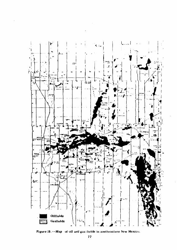
'I
• i ~
t,
--,/'
'. Oll/lelds~ Gasllelds
Figure 19. --Map
....... !. ." I, " I,--;-
, : • I
.Id'·':. ,.r ' 1:'I '''.J'- -
I""! {.!:':, , .~ I i" I

Southeaatern Hew Mexico ia now a vell-e.tabliabed 011· and
"."produclll1 area. TM ,aural ,eololY 18 well known, but uDexplored
larae area. atill re..in. The ••arch for .tratlarapbic trap. and
favorabl. atructur.a ID the d••per ,-rta of rhe Dela.ra baaio uDdoubted
I, viii re.ult la the dlacovety of DeW fl.ld.. ~ ara. viii probably
coatiaue to be ooe of the -oat aetiYely e.plorad ar.a. io the DAtion
becau•• of the blab .ucc••• ratio.
COIICLUSlOllS
that part of tlla Carl.bad potaab ar•• 111 Tp•• 21, 22, 23,
ao4 24 S., a•• 31 aDd 32 I., baa the loweat dea.itJ of drill bDl••
for potaab, 011, .Dd .a., il fartbeat fr~ the dlaaolutioa front la
c~ a.le ••cCion,_ baa a aubleantial Cblckaea. of cODlolldeted Coyer
above the ••It .action, aDd coat.laa the uxta. tbicluae•• of Salado
ro~tlOD ••It at re••oaabl••eptha below the aurtaca. a~ of the
aiDed-out pota.b aloe..., provide ua.ful &tor_ae.
78
SELECTED REFERlftCES
Adau, J. E., 1944, Upper Peraian Ochoa Serle. of Del.ware balIn, Welt
r..... and .outhe••tarD New Mexico: All. Auoc. Petroleua GeololUU
Bull., v. 28, DO. 11, p. IS96-1625.
___ 1965, Stratllraphlc-tactonlc develOp.eDt of Delaware balln: b.
Aa.oc. ratroleua Geoloa1lt. Bull., v. 49, DO. II, p. 2140-2148.
"'t••, R. L' J 1942, The 011 aDd sa' r ••ourc.' of Mev ....leo L'id .d~7:
Haw ....1«:0 Scbool KiM' Bull. 18, 320 p.
Ierl, L. G., 1910, Salt alaeral., in v. I, rvnda.8ntal a.pact., !!
Mackenzie, a. C., aet., Differeptlal thel'1lal analyall: Hew York,
Aead. PE••• , p. 463-415.
Bjorklund, L. J., aDd Motta, ~. S., 19S9, GeololY and vater re.ourc.'
of the C&rhbad ar••, Eddy County, Hev Mexico: U. S. ceDI. Survey
opeD-flle report, 322 p.
Bretz, J. Ho, aDd Borber" C. L" 1949, The OsaUala I'Dr.-tlon velt of
the Llano Iitacado Lii....xJ-/: Jour. GeololY, v. S1, DO. 5,
p. 417-490.
Cooper, J. I., 1962, Te.t hole. drilled io lupport of around-water
iove.tll.tion., Project Gname, ,Eddy Couoty, Hew Hexlco--b.lic
data report: u. S. Geol. Survey TBI-186, 116 p.
_____ 1962, Ground-water lDVe.tiaationa of the Project Gna.. .rea,
Eddy and Lea Counti•• , Hev Mexico: U. S. Geol. Survey Tll·a02,
61 p., 11 fi.l.
19
Cooper) J. B., and Glanz"D, V. H., 1911, GeohydrololY of P~oj.c~ Gnome
elte, Eddy Coun~y, New Hexico: U. S. Ceol. Survey Prof. Paper 112·.,
p. 1.1-1.24.
Cox, B. a., 1961, GeololY and hydrology between Lake HcHilland aDd
Carlebad Springe, Eddy County, Haw Mexico: U. S. Ceol. Survey
Watar-Supply Paper 1828, 48 p.
Dane, C. H., and Bacblun, G. 0., 1958, PreU.-inary .ao1oaic .p of
the .outMastern part of ~w H..:Lco: U. S. Gaol. Survey Hi.c.
Gool. loy. Hop 1-256.
Davie, J. G., aDd Shock, D. A., 1910, Solution ~oin& of thip-bedd8d
pota.b: Aa. lnat. HinioS MetaU. patrola.... Enaineara Teana.,
v. 247, p. 93-96.
P1edler, A. G., aDd Mye, S. 5., 1933, Geolo.y and around-water
c••oure•• of the ao.wall art•• iau b••la, Haw ~xico: U. S. G.ol.
Suryay ~at.r-Supply paper 639, 312 p.
'lawa, p! T., 19S4, Su..ary of eouthe•• t Hew Mexico ba•••at rock.,
!!. Hew Medco Gaol. Soc. Guidebook, 5th Field Coni., October 1954,
p. 114-116.
___ 1956, .....nt rock. of Taxae aDd eouttaea.t )lew Mexlco: Te....
Univ. Pub. 5605, 261 p.
Foat.r, a. W., aad Stipp, T. r., 1961, Pr.liainary seolosic and
ra li.f .p of tbe rrec..mriao rock. of Hev Mexico: Haw Hldco
Bur. Mine. and Minaral a••oure•• Circ. 57, 37 p.
80

Galley, J. £ •• 1958, Oil and ,eolo&y in the Per_lan a._in of texa.
and Nev Mexico, m Week., L. G., ed., Habitat of o11-~••,.pa.iulD:
Yul.a, Okl•• , Aa. A"Ge. retrol.u- Geologi.t., p. 395-446.
Gard, L. H., Jr., 1968, GeoloSic .tudi•• , ProJ.ct Gn~, 144y County,
New Hexlco: U. S. Gaol. Survey Prof. raper 589, JJ p.
Gle••~, S. c., .nd rulk, r. P., 1941, North Cowden fi.ld, Ector County,
T.... : Aa. A.eoc. r.trol.u- Geolo.i.t. Bull., v. 25, p. 593-629.
Hal., w. I., Bulbe., L. 5., .nd Cox, •• R., 1954, POI.ibl. iaprov...nt
of quality of wat.r of tha P.cu. River by diver,lon of brine .t
....1.1. leDd, Iddy County, New Hexico: "co, River C~., New
~xlco .nd T.... , 10 cooper.tion vith U. S. Ceol. Survey, W.t.r
R.e'~l1:ce. Dh., C.rbba", N. Mex., 43 p.
Halpenny, L. C., and Gr.eDe, p. ~., 1962, Hydrol.olo,y of p.rt. of
tbe capit.D a••f, Rev Mexico .nd T.xa.: Tuc.oD, Arizona, W.ter
Dev.lo,..nt Corp., 45 p., ] pl•• , 10 fil." 4 t.ble••
Hay•• , P. T., 1964, GeololY of tbe Gu.dalupe Mount.ioa, New Hexico:
U. S. Gaol. Survey Prof. P.per 446, 69 p.
Hendrick.on, G. I., .nd Jone., R. S., 1952, GeololY .nd around-w.ter
r ••ouree. of Eddy County, New,Mexieo: Nev Hlxieo Bur. Hine. and
Hiner.l a••oure.' Ground. ..v.ter Rapt. 3, 169 p.
Hill., J. M., 1963, Lat. P.I.ozoic t.ctonic••nd .aunt.in r.nl•• ,
ve.tern T.... to .outh.rn Color.do: Aa. A••DC. P.trol.u.
Geolo.l.t. Bull., v. 47, no. 9, p. 1109-1J25.
8\
Ho'CbeJ:l, C. L., 1949, GeOlaOrphic hiatol')' of the Car laNd C."ern&, &rea,
New MBxlco: Jour~ Geology, v. 57, no. 5, p. 464-476.
Joae., C. L., 1954, The occurr.nc••nd di.trlbuttoD of pota••twa
ai_rah in 'outhea.tern Hew Mexieo, 12 "W Hl:xlco Geol. Soc:.
Guidebook, 5th 'ield C~nf., OCtobar 1954: p. 107-112.
_____ 1960, Thick..... , charact.r, aDd .tructur. of Upper ••e-ian
.vaporit'. in part of Iddy County, Hev ",xtco: U. S. Gaol. Survey
TIlt-1033.
JaM', C. L., .nd Ha'.en, B. M., 1968, Ivaporit. ,.0).0&7 of rUtb
or••0118, CArl.bad dt.trtct, .outbea.t.rn Hev Hlxteo: U. S.
GOol. Survoy Bull. 1252-B, p. Bl-B21.
1811.y, Y. c., 1971, Geolol1 of the 'e,o', country, .outbea.t.rn
.. MIIxteo: Haw Healeo Bur. Mtoe' .nd Hi...ral ....DUrc•• HIhI. 24,
7S p.
Lao&, w. t. a., 1935, Upper 'et1l1aa. fot'Mtlon. of Delavara "aln of
'Iaxaa an4 Mev Mex.ico: Aa. A,.oc. r.,rola-. GeO).0ll.tl Bull.,
v. 19, nO. 2, p. 262-270.
__ 1942, ....1 be.. of Salado foruUon tn 'letcber pota.b cor.
t •• t ne.1' c&rhbad, Mev Mexico: _. A••oc. p.trol.~ GeololtlU
Bull., v. 26, no. I, p. 63..79.
McKe', B. D., Or1.1, S. S;,,:.od _tben" 1967,... ral.ot.clonte .p'of the '.ratan Syue.: U. S. GeoL Surw, Mi.e. Geot. Inv.
Ml.p I-450, text of 164 p.
82
HeMe.i, R. P., 1965, Bydrodyna.lcI of the Peral.n B'lln, !! Fluid. in
lub.urf.c. envirou.ent8-·a .~oeium: ... Ae.oc. Petroleu.
Geolo&iltl ~a. 4, p. 308~326.
Morg.n, A. M., .04 S.yre, A. lil., 1942, GeoIOIY, !!!. iii. sJ National
leloureel Plannina Board, 1942, Peeo' River Joint Inv.atiaatioD-.
aeporta of the participatiDI 'Slaclea: W••hiDaton, U. S. Covt.
Printina Offic., p. 28-38.
Mottl, w. S., 1962, GeololY of the Welt carlebad quadr.nll., New
Moxleo, u. S. Gool. Survoy Gool. q.od. Mop GQ-167.
______ 1912, GeololY altd paleoenviroraentl of the northenl
.....nt, capitan 1.1f, Nev Medeo and Welt Texa.: Geol. Soc.
"'rlea Bull., v. 83, no. 3, p. 701-122.
BeveU, 11. D., aacl other., 19~J, The Plhll'n reef ca.plex of the
Guad.lupe Hount.tn' relton, Texa••ad .ew ~xico-·••tudy in
,al.oecololY: S'n Francilco, W. H. rr.e..n & Co., 236 p.
Mew ~.ico Ge010llcal Soclety, 19~4, GuideboOk of loutbellt.rn -.v
~xlco, 5th Pield Conf., Qet. 21-24, 1954: 209,.
NichollOD, Alexander, Jr., and Clebleh, Alfred, Jr., 1961, Glology
.net arouocl-vater condition. in .outbern Lea County, )lev MI..ico:
Nev H...:ieo Bdr. Hinel .nd Hiner.l Il••aurcel Ground-Wlt.r
Rapt. 6, 123 p.
P'.', L••• , .nd Ada.. , J. I., 1940, Str.tiar.phy, "Itern Midland '''In,
'I..... , !!! Del'ord, a. It., .nd Lloyd, I. R., .de., Welt T.ua-Haw ttexiec
'~OIi~, Pt. 1: Aa. A.loc. Petroleua Geoloa18t8 Bull., v. 24,
DO. 1, p. S2·64.
63
Rand McNally and Co., 1972, Coaaerclal atla. and ..rketlng gulde:
Chicaao, aand McNally and Co., 661 p.
I.lcba:rdloon, G. I., 1904, a.poEt of • 1:eConnaia.&nce in trana-Peeoa
Texa., north of the Texa. and 'aclUc aaUway: T.... Untv.
H1neral Sueve, Bull. '9, 119 p.
lo.well Geoloaical Society, 1960, Tba oil and sa' field. of .outh
e.,tern New Mexico, 1960 aupple"nt: 101"ell, N. ~.'I 229 p.
IOlve11 Geological Society, 1961, fbe otl aad ,al fl.1d. of louth-
e••terD Nev He.lco, 1966 .upple..nt: ROI~II, N. ~•. , 18S p.
_____ 1968, The ao.vell art••iau b••in: aoavell, H. ~x., 32 p.
SaDler, W. A., and S.ult., W. L., 1971, Dev.lo~Gt. in w.at T.... and
••,tll'n Hew Mexico 1n 1910: Aa. A••oc.. P.trol...... Glolo.l.t. lull
v. 55, ao. 7, p. 1037-1042.
Silver. B. A' J and Todd, R. G., 1969, re~t.n cycllc .trata, northern
IUd land and o.la..,are baala., Wen Tex•• and .ouche.lcero He"
"x,lco: All. A..oc. 'etrol,u. GeolOll8t. lull., v. 53, no. 11,
p. 222J·22~1.
Stlpp, T. r., 1956, Major .truetural feature. and .eoloale hi.tory of
1000thealtern Hew Maxlco, .!.!. Stipp, T. r., awl otherl, ada.,
TbIi 0:1.1 lad aa' fielda of aoutbea.tern Nev ",x,leo--a a~o.lu.,
p. 16-20 fi9Sl7.
Stlpp, T. P., and Hataler, L••. , 1956, Prell.toacy Itruetur. contour _
of a part of 8ouc:heauero Nev Me:deo ahovtna 011 apd ••• develo,..
u. S. Ceol. Sur".y Oil and Ca. In... Map {I4.-Ul [19517.
84

Stipp, T. r., and otherl, ed8., 1956, The oil and lal fielda of
louthe.ltern New Hexico--a ly.-po8iwa: R08well, Nev Hexico,
.GOwell GOol. Soc.; 1956, 376 p. L195r7.
Stotel..yer, R. I., 1969, Rev ~.iCOI8 1961 .ioerat production by
countiea: New Hexico Bur. Hines and Hineral Relourcea, Hineral
aesouree. Rept. 1, 23 p.
Tappan, J. T., and Lorenz, J. J., 1969, Carlabad Site Roll Up: aeynolda
Ileetriea1. IOlineerina Co., lac., NVO-410-2, 25 p.
Thail, C. V., and others, 1942, Ground-vater hydrololY of ar.a. in the
reeN Vaney, Hew Mexico, !!!. iii. s~7 Natl. Re.ouree. Plaaninl Board,
1942, rlCOI River Joint Inveltilation--R.eportl of the partieipatina
aleacle.: Wa.blnatoD,·U. S. Govt. Printing Offie., p. 38-75, 11 fi~
TrolUDser, W. V., 1968, Surface evidence of deep Itructure in the
Delaware ... lD, !! Delavare ".lD exploration, 1968 Guidebook:
Welt Texal Gaol. Soc. Pub. 68-SS, p. 81-104.
U. S. Gao1oaieal Survey, 1962, Project Gno.e--Hydrololic and .eoloBlc
studie.: U. S. Atc.ic .anerlY c~. PHI-130P.
Vertr••• , C. D., Atehl,oD, C. H., and Ivanl, G. L., 1959, Peleozoic
,loloBY of the Delavare aDd V.l VerdI balinl, !!! Geology of the
Cbittl. Arch aDd the area north to tM PeeOl River': Corpus ChriBtt
Geol. Soc. 10th AnD. Pield Tri" April 1960 LGuidlbo~7, p. 32-41
L19627. allo19 W.lt Texa_ Geol. Soc. Guidebook, Nov.·19S9, p. 64-7
85

Vine, J. D., 1960, aacent da.al atructur•• in aouthe••tarn Hew ~.ico:
Aa. A••oc. Petrolaua Geoloa1at. Bull., v. 44, no. 12, p. 1903-1911.
_____ 1963, Surfaca .ao1ol1 of the ..ab Draw quadranl1a, Iddy County,
Hew ~.lco: U. S. Gaol. Surva,. lull. 1141-., p. 11-846.
86


![Sustainable Regulatory Compliance[1]](https://img.pdfslide.us/doc/110x75/577cdd861a28ab9e78ad346d/sustainable-regulatory-compliance1.jpg)