Embed Size (px)
Citation preview
Ž .Geomorphology 33 2000 183–207
Long-term fluvial archives in NW France: response of the Seineand Somme rivers to tectonic movements, climatic variations and
sea-level changes
Pierre Antoine a,), Jean Pierre Lautridou b, Michel Laurent c
a UMR 9944 CNRS ‘‘Prehistoire et Quaternaire’’ unite: Stratigraphie et PaleoenÕironments Quaternaires, UFR de Geographie,´ ´ ´ ´UniÕersite des Sciences et Technologies de Lille, 59 655 VilleneuÕe d’Ascq cedex, France´
b ER 109 CNRS, Centre de Geomorphologie, 24 rue des Tilleuls 14 000 Caen, France´c ENS Chimie Paris, 11 rue Pierre et Marie Curie, 75231 Paris, France
Accepted 18 July 1999
Abstract
The Seine and the Somme are the two main rivers flowing from northwestern France into the Channel. During thePleistocene cold stages both rivers were tributaries of the River Manche which was exporting sediments into the centraldeeps of the Channel. The River Seine has a very well developed terrace system recording incision that began at around 1Ma. The same age is proposed for the beginning of the main incision in the Somme Valley on the basis of morphostratigra-phy, pedostratigraphy, palaeontology, palaeomagnetism and ESR datings. The uplift rate deduced from analysis of the Seineand Somme terrace systems is of 55 to 60 mrMa since the end of the Lower Pleistocene. The response of the two rivers toclimatic variations, uplift and sea-level changes is complex and variable in the different parts of the river courses. Forexample, the evolution of the lower Seine system is influenced by uplift and climate changes but dominated by sea-levelchanges. In the middle Seine the system is beyond the impact of sea-level variations and shows a very detailed response toclimatic variations during the Middle and Upper Pleistocene in a context of uplift. The Somme Valley response appears to bemore homogeneous, especially in the middle valley, where the terrace system shows a regular pattern in which incisionoccurs at the beginning of each glacial period against a general background of uplift. Nevertheless, the lower Somme Valleyand the Palaeo-Somme in the Channel area indicate some strong differences compared with the middle valley: influence ofsea-level variations and probably differences in rates of tectonic uplift between the Channel and the present continent. Thedifferences in the responses of the two river valleys during the Pleistocene are related to differences in the size of the fluvialbasins, to the local tectonic characteristics, to the geometry of the platform connected to the lower parts of the valleys and to
) Corresponding author. Fax: q33-3-20-33-60-75.Ž .E-mail address: [email protected] P. Antoine .
0169-555Xr00r$ - see front matter q 2000 Elsevier Science B.V. All rights reserved.Ž .PII: S0169-555X 99 00122-1
( )P. Antoine et al.rGeomorphology 33 2000 183–207184
the hydrodynamic characteristics of each river. Finally, it is shown from these examples that the multidisciplinary study ofPleistocene rivers is a very efficient tool for the investigation of neotectonic activity. q 2000 Elsevier Science B.V. Allrights reserved.
Keywords: River Seine; River Somme; Quaternary; neotectonics
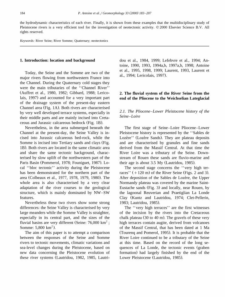
1. Introduction: location and background
Today, the Seine and the Somme are two of themajor rivers flowing from northwestern France intothe Channel. During the Quaternary cold stages theywere the main tributaries of the ‘‘Channel River’’ŽAuffret et al., 1980, 1982; Gibbard, 1988; Lerico-
.lais, 1997 and accounted for a very important partof the drainage system of the present-day eastern
Ž .Channel area Fig. 1A . Both rivers are characterisedby very well developed terrace systems, especially intheir middle parts and are mainly incised into Creta-
Ž .ceous and Jurassic calcareous bedrock Fig. 1B .Nevertheless, in the area submerged beneath the
Channel at the present-day, the Seine Valley is in-cised into Jurassic calcareous bed-rock, while the
ŽSomme is incised into Tertiary sands and clays Fig..1B . Both rivers are located in the same climatic area
and share the same tectonic background, charac-terised by slow uplift of the northwestern part of the
Ž .Paris Basin Pommerol, 1978; Founiguet, 1987 . Lo-cal ‘‘bloc tectonic’’ activity during the Pleistocenehas been demonstrated for the northern part of the
Ž .area Colbeaux et al., 1977, 1978, 1979, 1980 . Thewhole area is also characterised by a very clearadaptation of the river courses to the geologicalstructure, which is mainly dominated by NW–SWfeatures.
Nevertheless these two rivers show some strongdifferences: the Seine Valley is characterised by verylarge meanders while the Somme Valley is straighter,especially in its central part, and the sizes of the
Ž 2fluvial basins are very different Seine: 76,000 km ;2 .Somme: 5,800 km .
The aim of this paper is to attempt a comparisonbetween the responses of the Seine and Sommerivers to tectonic movements, climatic variations andsea-level changes during the Pleistocene, based onnew data concerning the Pleistocene evolution of
Žthese river systems Lautridou, 1982, 1985, Lautri-
dou et al., 1984, 1999; Lefebvre et al., 1994; An-toine, 1990, 1993, 1994a,b, 1997a,b, 1998; Antoineet al., 1995, 1998, 1999; Laurent, 1993, Laurent et
.al., 1994; Lericolais, 1997 .
2. The fluvial system of the River Seine from theend of the Pliocene to the Weichselian Lateglacial
2.1. The Pliocene–Lower Pleistocene history of theSeine–Loire
The first stage of Seine–Loire Pliocene–LowerPleistocene history is represented by the ‘‘Sables de
Ž .Lozere’’ Lozere Sands . They are plateau deposits` `and are characterised by granules and fine sandsderived from the Massif Central. At that time theRiver Loire was a tributary of the Seine. Down-stream of Rouen these sands are fluvio-marine and
Ž .their age is about 3.5 My Lautridou, 1985 .The second stage concerns the ‘‘very high ter-
Ž . Ž .races’’ q120 m of the River Seine Figs. 2 and 3 .After deposition of the Sables de Lozere, the Upper`Normandy plateau was covered by the marine Saint-
Ž .Eustache sands Fig. 3 and locally, near Rouen, bythe lagoonal Reuverian and Praetiglian La Londe
ŽClay Kuntz and Lautridou, 1974; Clet-Pellerin,.1983; Lautridou, 1985 .
The ‘‘very high terraces’’ are the first witnessesof the incision by the rivers into the Cretaceous
Ž .chalk plateau 30 to 40 m . The gravels of these veryhigh terraces contain augite, derived from volcanoesof the Massif Central, that has been dated at 1 MaŽ .Tourenq and Pomerol, 1995 . It is probable that theRiver Loire continued to be a tributary of the Seineat this time. Based on the record of the long se-
Žquences of La Londe, the tectonic events graben.formation had largely finished by the end of the
Ž .Lower Pleistocene Lautridou, 1985 .
( )P. Antoine et al.rGeomorphology 33 2000 183–207 185
Ž . Ž .Fig. 1. A Location of the Seine and Somme river valleys and of their extension beneath the present-day English Channel ; B SimplifiedŽgeology and structure of the Eastern Channel according to Lericolais, 1997 modified, and to the Carte Geologique de la France, BRGM,´
.1996 . NPV: Northern Palaeovalley, MPV: Median Palaeovalley, GRD: Greenwich Deep, CD: Cotentin Deep, BF: Bray Fault, FS: Seine.Fault, SVBF: St. Valery–Boismont faults .
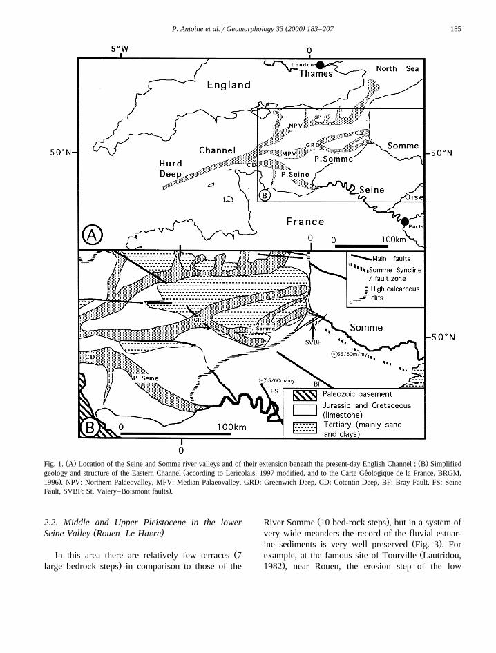
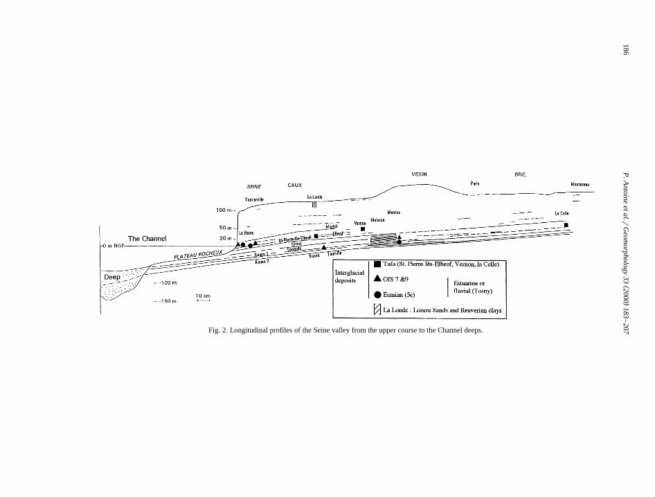
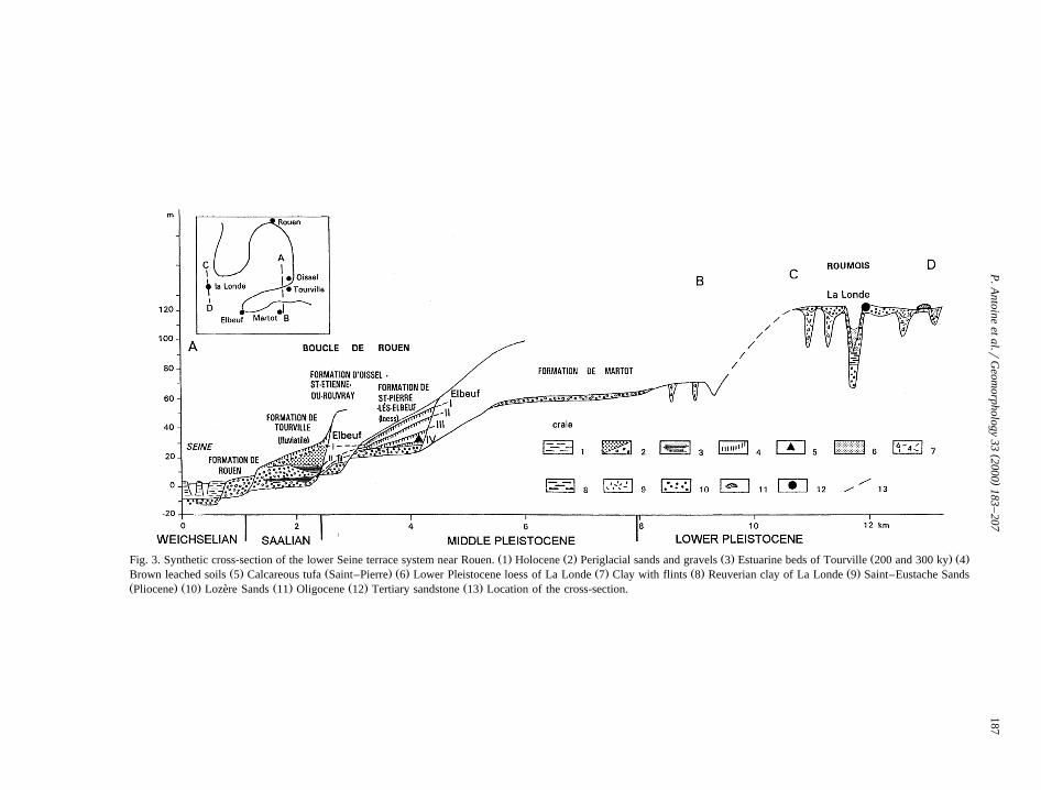
2.2. Middle and Upper Pleistocene in the lower( )Seine Valley Rouen–Le HaÕre
ŽIn this area there are relatively few terraces 7.large bedrock steps in comparison to those of the
Ž .River Somme 10 bed-rock steps , but in a system ofvery wide meanders the record of the fluvial estuar-
Ž .ine sediments is very well preserved Fig. 3 . ForŽexample, at the famous site of Tourville Lautridou,
.1982 , near Rouen, the erosion step of the low
()
P.A
ntoineet
al.rG
eomorphology
332000
183–
207186
Fig. 2. Longitudinal profiles of the Seine valley from the upper course to the Channel deeps.
()
P.A
ntoineet
al.rG
eomorphology
332000
183–
207187
Ž . Ž . Ž . Ž . Ž .Fig. 3. Synthetic cross-section of the lower Seine terrace system near Rouen. 1 Holocene 2 Periglacial sands and gravels 3 Estuarine beds of Tourville 200 and 300 ky 4Ž . Ž . Ž . Ž . Ž . Ž .Brown leached soils 5 Calcareous tufa Saint–Pierre 6 Lower Pleistocene loess of La Londe 7 Clay with flints 8 Reuverian clay of La Londe 9 Saint–Eustache Sands
Ž . Ž . Ž . Ž . Ž .Pliocene 10 Lozere Sands 11 Oligocene 12 Tertiary sandstone 13 Location of the cross-section.`
( )P. Antoine et al.rGeomorphology 33 2000 183–207188
Ž .terrace q2 m is covered by three periglacial allu-vial sediment bodies separated by two interglacialestuarine silt beds, including a typical Saalian mam-
Ž . Žmal fauna macrofauna and rodents Lautridou,.1982, 1985 . The upper one has been dated at 200
Ka by ESR–OSL, and the lower at 300 Ka by OSLŽ .Balescu et al., 1991, 1997 . The other periglacialgravels in this area are the Oissel Formation lying at10 m above the bedrock of the Tourville terrace, andthen the Elbeuf Formation, 15 m higher, which iscovered by the famous loessic Saint Pierre-Forma-
Ž .tion Lautridou, 1985 , which contains fourpalaeosols, and a tufa on the top of the Elbeuf IV
Ž .soil Fig. 3 .The molluscan fauna from this tufa, as at Vernon
Ž .between Rouen and Paris and at La Celle-sous-Ž .Moret upstream of Paris , indicates a forested inter-
glacial environment warmer than the Holocene. TheŽfauna, dated at 350–400 Ka using UrTh from
.Vernon, Lecolle et al., 1990 , has also been de-´scribed in Britain from the Hoxnian tufa sites of
ŽHitchin and Icklingham Rousseau, 1987; Rousseau.et al., 1992 . Above this Saint-Pierre-les-Elbeuf ter-
race, at 30 m O.D. near Rouen, there is an older,Ž .very weathered terrace Martot that can be traced
downstream to Le Havre, but is very discontinuousŽ . Župstream Fig. 2 . Below the Tourville terrace low
.terrace , there are the two Weichselian valley-bottomŽ .gravels: Rouen 1 and Rouen 2 Figs. 2 and 3 . These
gravel beds, like the Tourville Formation, continueŽ .below the English Channel Fig. 2 , as far as the
Ž . Žlarge depression of the Hurd Deep Fig. 1A Alducet al., 1979; Auffret et al., 1980, 1982; Lericolais,
.1997 .
2.3. The Middle Pleistocene fluÕial system of the(middle Seine Valley in the ‘‘Region Mantaise’’ From
)Elbeuf to Paris
Fifteen kilometres upstream of Elbeuf–Les An-delys, characterised by a straight and narrow channel
Ž .without terraces Fig. 2 , there is a characteristicsystem of meanders, smaller than downstream andmore stable, with many steps eroded into the chalkbedrock. Dating from 600 to about 20 Ka there are16 bedrock-steps, many more than downstream, per-haps because of differences in the longitudinal gradi-
Ž .ent, which is lower upstream 0.2% , and in the
Žpattern of the meanders stable meanders in themiddle valleyrmigrating meanders in the lower val-
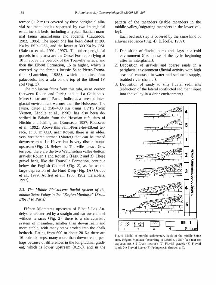
.ley .Each bedrock step is covered by the same kind of
Ž . Ž .alluvial sequence Fig. 4 , Lecolle, 1989 :´
1. Deposition of fluvial loams and clays in a coldŽenvironment first phase of the cycle beginning
.after an interglacial .2. Deposition of gravels and coarse sands in a
Žperiglacial environment fluvial activity with highseasonal contrasts in water and sediment supply,
.braided river channel .3. Deposition of sandy to silty fluvial sediments
Žreduction of the lateral soliflucted sediment input.into the valley in a drier environment .
Fig. 4. Model of morpho-sedimentary cycle of the middle SeineŽ . Žarea, Region Mantaise according to Lecolle, 1989 see text for´ ´
. Ž . Ž . Ž .explanation . 1 Chalk bedrock 2 Fluvial gravels 3 FluvialŽ . Ž . Ž .sands 4 Fluvial loams 5 Pedogenesis brown soil .
( )P. Antoine et al.rGeomorphology 33 2000 183–207 189
4. End of the cold period, climatic improvement andvegetation colonisation: major erosion and lateral
Žincision creating a new step into the bedrock 1–2.m maximum. .
Ž5. Climatic Optimum interstadial, rarely inter-.glacial : pedogenesis and soil formation at the top
Ž .of the previous deposits brown soil , depositionŽ .of overbank silts final phase of the cycle .
The cycle then returns to stage 1 at the beginningof a new cold period.
Attempts to correlate the middle Seine sequencewith the lower Seine system, and especially with theTourville Formation, have used altimetry of the mainbedrock steps, large mammal remains and the posi-tion of the interglacial deposits in the various se-
Ž .quences Lautridou et al., 1984 .
(2.4. The upper Seine Valley from Paris to Mon-)tereau
In the city of Paris there are again several largeŽmeanders incised into soft Tertiary sediments mainly
.sands and clays and a stepped terrace system similarŽ .to that of the lower Seine Fig. 2 . Upstream, the
system, with only few meanders is characterised by afew terraces separated by well developed bedrock
Ž .steps 5 to 10 m , especially near Montereau at theconfluence with the River Yonne. It seems that themain terraces defined at Rouen can be correlatedwith those of the region of Paris and Montereau. Forexample, at Paris mammal remains discovered in asilty bed included in the alluvial formation of thelow terrace have been dated to 162"9 to 206"18
Ž .ka by UrTh technique Durbet et al., 1997 . Thesedates are in agreement with that of the upper part of
Žthe Tourville Formation near Rouen Balescu et al.,.1997 .
Finally, the upper Seine valley is also charac-terised by well preserved Lateglacial silty sediments.These sediments have been dated using 14 C frommany Magdalenian archaeological settlementsŽ .11.9–13 ky BP, Roblin-Jouve and Rodriguez, 1997 .In this area a first incision phase is identified be-tween the end of the Upper Pleniglacial and the
Ž .Lateglacial Roblin-Jouve and Rodriguez, 1997 , asŽhas been demonstrated in the Somme valley Antoine,
.1997a,b and in other northern European Rivers
Ž .Vandenberghe et al., 1994 . As regards the UpperPleistocene, there is good correlation between thetwo younger alluvial formations of the lower SeineŽ .Rouen 1 and Rouen 2 and the WeichselianPleniglacial and Lateglacial gravel accumulations inthe upper Seine.
Finally, the absence of Lateglacial sediments inthe lower Seine may be related to the occurrence ofstrong fluvial erosion during the Holocene, espe-cially at the beginning of the Preboreal, the impact of
Ž .which was stronger downstream Antoine, 1997a .
3. The terrace system of the middle Somme Valley
3.1. General context
The Somme Valley is a small, NW–SE orientatedŽ .valley in northern France Fig. 1B , developed upon
homogeneous Chalk bedrock of Upper Cretaceousage. In the whole area the main fluvial systems are
Žparallel to the NW–SE structural features i.e., the.Somme syncline, Fig. 1B . The area where the ter-
races are best developed is the middle Somme valleyŽ .about 70 km long . In the lower valley all theterraces are preserved on the left bank and the
Ž .occurrence of faults crossing the valley SW–NEŽmakes upstream correlations very difficult Figs. 1B
.and 5 .The Somme Valley is well known for its impor-
Žtant prehistoric archaeology Prestwich, 1859; Com-mont, 1909, 1910, 1911; Breuil and Koslowsky,1931; Bordes, 1954; Tuffreau, 1987, Tuffreau and
.Antoine, 1995 and its complex Quaternary terraceŽsystem Bourdier, 1969, 1984; Bourdier et al.,
1974a,b; Somme and Tuffreau, 1978; Somme et al.,´ ´1984; Haesaerts and Dupuis, 1986; Antoine, 1989,
.1990, 1994a .New research, based on field surveys combined
Žwith environmental studies palynology, palaeontol-ogy, malacology, micromammal: Munaut, 1988, Mu-naut and Defgne 1997; Moigne, 1989; Auguste, 1995;´
.Rousseau et al, 1992; Antoine et al., 1995 , haveallowed the proposal of a reference sequence forPleistocene river development in northern France
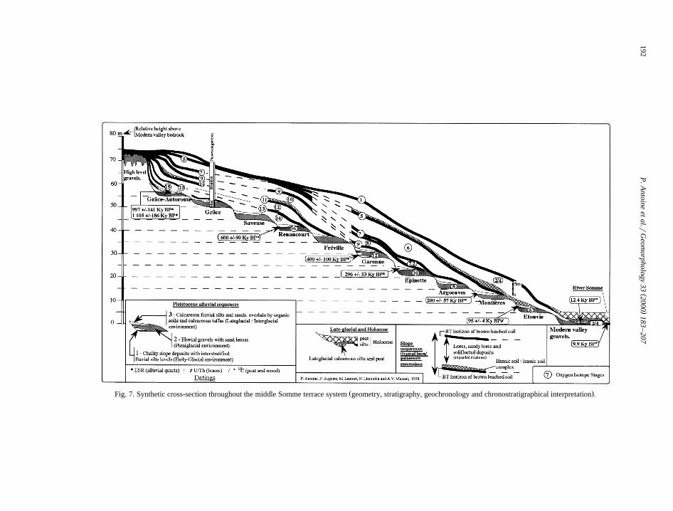
Žthat is summarised by Figs. 5–7 Antoine, 1990,.1993, 1994a . The chronostratigraphical interpreta-
tion of this sequence is controlled by magneto-
()
P.A
ntoineet
al.rG
eomorphology
332000
183–
207190
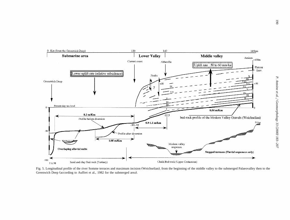
Ž .Fig. 5. Longitudinal profile of the river Somme terraces and maximum incision Weichselian , from the beginning of the middle valley to the submerged Palaeovalley then to theŽ .Greenwich Deep according to Auffret et al., 1982 for the submerged area .
( )P. Antoine et al.rGeomorphology 33 2000 183–207 191
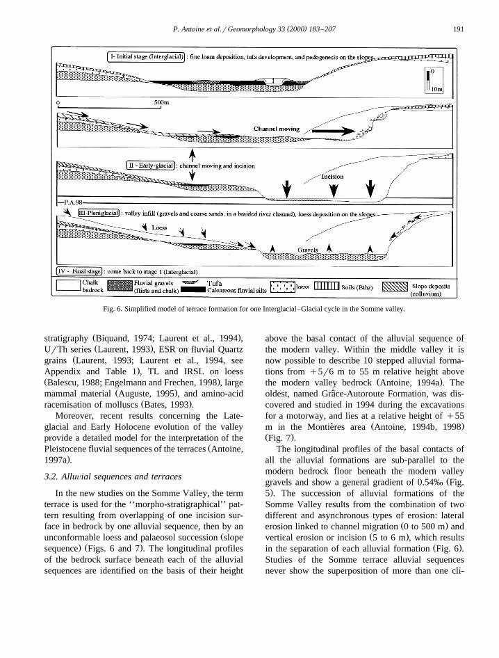
Fig. 6. Simplified model of terrace formation for one Interglacial–Glacial cycle in the Somme valley.
Ž .stratigraphy Biquand, 1974; Laurent et al., 1994 ,Ž .UrTh series Laurent, 1993 , ESR on fluvial Quartz
Žgrains Laurent, 1993; Laurent et al., 1994, see.Appendix and Table 1 , TL and IRSL on loess
Ž .Balescu, 1988; Engelmann and Frechen, 1998 , largeŽ .mammal material Auguste, 1995 , and amino-acid
Ž .racemisation of molluscs Bates, 1993 .Moreover, recent results concerning the Late-
glacial and Early Holocene evolution of the valleyprovide a detailed model for the interpretation of the
ŽPleistocene fluvial sequences of the terraces Antoine,.1997a .
3.2. AlluÕial sequences and terraces
In the new studies on the Somme Valley, the termterrace is used for the ‘‘morpho-stratigraphical’’ pat-tern resulting from overlapping of one incision sur-face in bedrock by one alluvial sequence, then by an
Žunconformable loess and palaeosol succession slope. Ž .sequence Figs. 6 and 7 . The longitudinal profiles
of the bedrock surface beneath each of the alluvialsequences are identified on the basis of their height
above the basal contact of the alluvial sequence ofthe modern valley. Within the middle valley it isnow possible to describe 10 stepped alluvial forma-tions from q5r6 m to 55 m relative height above
Ž .the modern valley bedrock Antoine, 1994a . Theoldest, named Grace-Autoroute Formation, was dis-ˆcovered and studied in 1994 during the excavationsfor a motorway, and lies at a relative height of q55
Ž .m in the Montieres area Antoine, 1994b, 1998`Ž .Fig. 7 .
The longitudinal profiles of the basal contacts ofall the alluvial formations are sub-parallel to themodern bedrock floor beneath the modern valley
Žgravels and show a general gradient of 0.54‰ Fig..5 . The succession of alluvial formations of the
Somme Valley results from the combination of twodifferent and asynchronous types of erosion: lateral
Ž .erosion linked to channel migration 0 to 500 m andŽ .vertical erosion or incision 5 to 6 m , which results
Ž .in the separation of each alluvial formation Fig. 6 .Studies of the Somme terrace alluvial sequencesnever show the superposition of more than one cli-
()
P.A
ntoineet
al.rG
eomorphology
332000
183–
207192
Ž .Fig. 7. Synthetic cross-section throughout the middle Somme terrace system geometry, stratigraphy, geochronology and chronostratigraphical interpretation .
()
P.A
ntoineet
al.rG
eomorphology
332000
183–
207193
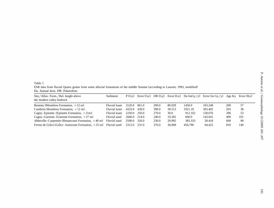
Table 1Ž .ESR data from fluvial Quartz grains from some alluvial formations of the middle Somme according to Laurent, 1993, modified
Da: Annual dose, DR: Palaeodose.
Ž . Ž . Ž . Ž . Ž . Ž . Ž .SiterAlluv. Form.rRel. height above Sediment P Gy Error Gy DR Gy Error Gy Da mGyry Error m Gyry Age Ky Error Kythe modern valley bedrock
Ž .Boutmy Montieres Formation, q12 m Fluvial loam 3120.0 861.0 290.0 80.029 1450.0 103.248 200 57`.Cambron Montieres Formation, q12 m Fluvial loam 4333.0 439.0 390.0 39.513 1921.18 303.402 203 38`
Ž .Cagny–Epinette. Epinette Formation, q21m Fluvial loam 2250.0 250.0 270.0 30.0 912.162 128.076 296 53Ž .Cagny–Garenne. Garenne Formation, q27 m Fluvial sand 2666.0 214.0 240.0 19.265 600.0 143.641 400 101
Ž .Abbeville–Carpentier Renancourt Formation, q40 m Fluvial sand 2500.0 326.0 230.0 29.992 383.333 28.418 600 90Ž .Ferme de Grace Grace–Autoroute Formation, q55 m Fluvial sand 2312.0 231.0 370.0 36,968 456,790 64,423 810 140ˆ ˆ
( )P. Antoine et al.rGeomorphology 33 2000 183–207194
Žmatic succession glacial–interglacial or glacial–.lateglacial . The same type of simple fluvial se-
quence is common in other river valleys of northernFrance such as Scarpe at Biache–Saint-VaastŽ .Somme et al., 1988 or in northwestern Europe such´
Žas at Maastricht–Belvedere Vandenberghe et al.,´ `. Ž1985 and the Haine Valley Haesaerts, 1984; Hae-
.saerts and Dupuis, 1986 , but it does not occur withthe same regularity in these terrace systems.
From stratigraphic, sedimentological and biocli-matic studies, the alluvial sequences appear to repre-sent a simplified budget of fluvial sedimentation
Ž .during a glacial–Interglacial cycle Figs. 6–9 :
1. Slope deposits with interstratified fluvial siltsŽEarly-glacial, at the bottom and at the valley
.margins near the slope; rarely preserved2. Coarse fluvial gravels and sands: budget of the
pleniglacial sedimentation, well preserved, andcorresponding to the most important and the
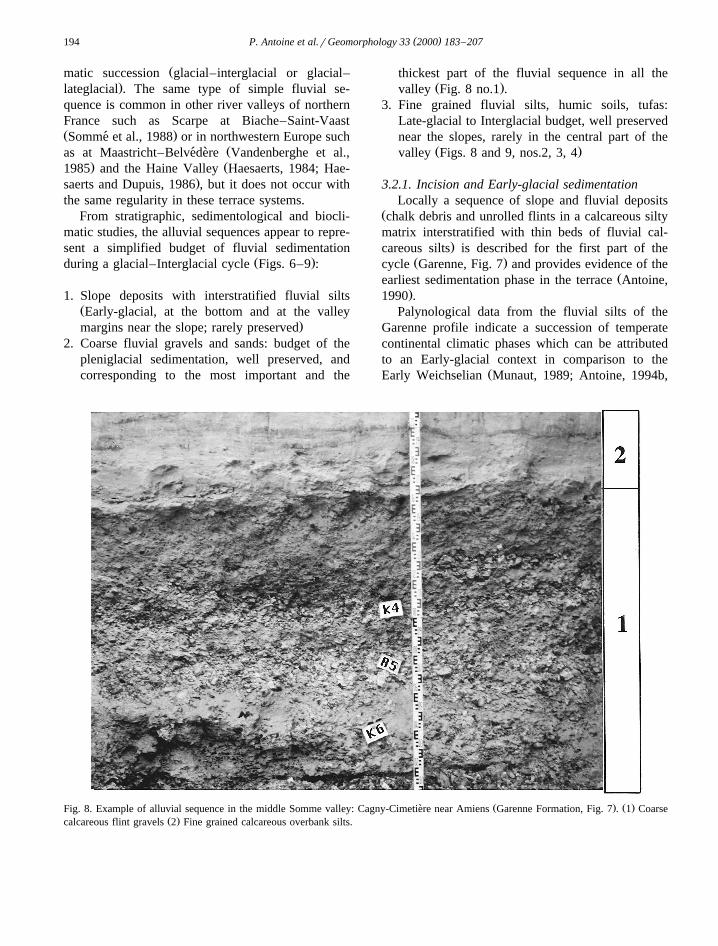
thickest part of the fluvial sequence in all theŽ .valley Fig. 8 no.1 .
3. Fine grained fluvial silts, humic soils, tufas:Late-glacial to Interglacial budget, well preservednear the slopes, rarely in the central part of the
Ž .valley Figs. 8 and 9, nos.2, 3, 4
3.2.1. Incision and Early-glacial sedimentationLocally a sequence of slope and fluvial deposits
Žchalk debris and unrolled flints in a calcareous siltymatrix interstratified with thin beds of fluvial cal-
.careous silts is described for the first part of theŽ .cycle Garenne, Fig. 7 and provides evidence of the
Žearliest sedimentation phase in the terrace Antoine,.1990 .
Palynological data from the fluvial silts of theGarenne profile indicate a succession of temperatecontinental climatic phases which can be attributedto an Early-glacial context in comparison to the
ŽEarly Weichselian Munaut, 1989; Antoine, 1994b,
Ž . Ž .Fig. 8. Example of alluvial sequence in the middle Somme valley: Cagny-Cimetiere near Amiens Garenne Formation, Fig. 7 . 1 Coarse`Ž .calcareous flint gravels 2 Fine grained calcareous overbank silts.
( )P. Antoine et al.rGeomorphology 33 2000 183–207 195
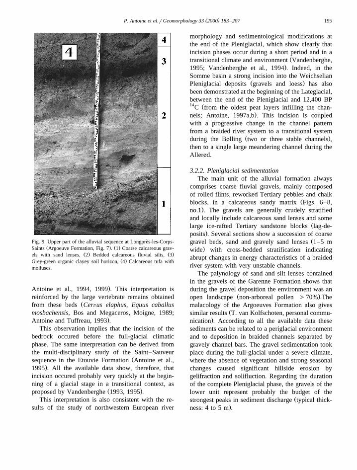
Fig. 9. Upper part of the alluvial sequence at Longpres-les-Corps-`Ž . Ž .Saints Argoeuve Formation, Fig. 7 . 1 Coarse calcareous grav-
Ž . Ž .els with sand lenses, 2 Bedded calcareous fluvial silts, 3Ž .Grey-green organic clayey soil horizon, 4 Calcareous tufa with
molluscs.
.Antoine et al., 1994, 1999 . This interpretation isreinforced by the large vertebrate remains obtained
Žfrom these beds CerÕus elaphus, Equus caballusmosbachensis, Bos and Megaceros, Moigne, 1989;
.Antoine and Tuffreau, 1993 .This observation implies that the incision of the
bedrock occured before the full-glacial climaticphase. The same interpretation can be derived fromthe multi-disciplinary study of the Saint–Sauveur
Žsequence in the Etouvie Formation Antoine et al.,.1995 . All the available data show, therefore, that
incision occured probably very quickly at the begin-ning of a glacial stage in a transitional context, as
Ž .proposed by Vandenberghe 1993, 1995 .This interpretation is also consistent with the re-
sults of the study of northwestern European river
morphology and sedimentological modifications atthe end of the Pleniglacial, which show clearly thatincision phases occur during a short period and in a
Žtransitional climate and environment Vandenberghe,.1995; Vandenberghe et al., 1994 . Indeed, in the
Somme basin a strong incision into the WeichselianŽ .Pleniglacial deposits gravels and loess has also
been demonstrated at the beginning of the Lateglacial,between the end of the Pleniglacial and 12,400 BP14 ŽC from the oldest peat layers infilling the chan-
.nels; Antoine, 1997a,b . This incision is coupledwith a progressive change in the channel patternfrom a braided river system to a transitional system
Ž .during the Bølling two or three stable channels ,then to a single large meandering channel during theAllerød.
3.2.2. Pleniglacial sedimentationThe main unit of the alluvial formation always
comprises coarse fluvial gravels, mainly composedof rolled flints, reworked Tertiary pebbles and chalk
Žblocks, in a calcareous sandy matrix Figs. 6–8,.no.1 . The gravels are generally crudely stratified
and locally include calcareous sand lenses and someŽlarge ice-rafted Tertiary sandstone blocks lag-de-
.posits . Several sections show a succession of coarseŽgravel beds, sand and gravely sand lenses 1–5 m
.wide with cross-bedded stratification indicatingabrupt changes in energy characteristics of a braidedriver system with very unstable channels.
The palynology of sand and silt lenses containedin the gravels of the Garenne Formation shows thatduring the gravel deposition the environment was an
Ž .open landscape non-arboreal pollen )70% .Themalacology of the Argoeuves Formation also gives
Žsimilar results T. van Kolfschoten, personal commu-.nication . According to all the available data these
sediments can be related to a periglacial environmentand to deposition in braided channels separated bygravely channel bars. The gravel sedimentation tookplace during the full-glacial under a severe climate,where the absence of vegetation and strong seasonalchanges caused significant hillside erosion bygelifraction and solifluction. Regarding the durationof the complete Pleniglacial phase, the gravels of thelower unit represent probably the budget of the
Žstrongest peaks in sediment discharge typical thick-.ness: 4 to 5 m .

( )P. Antoine et al.rGeomorphology 33 2000 183–207196
3.2.3. Lateglacial to interglacial sedimentationThe fine fluvial deposits of the upper unit corre-
spond to the final phase of alluvial sedimentationwithin the terrace formation and are characterised by
Ž .low energy facies Figs. 8, 9 no.2 , deposited in anŽ .interglacial context maximal thickness 1.5 m . In-
deed, during this phase the hillsides were stabilisedby vegetation. They represent the last phase of allu-vial sedimentation and are contemporaneous with theinfilling of the valley and its stabilisation. This se-quence ends with the development of immature hu-
Ž .mic soils and calcareous tufas Fig. 9, no.3, 4 .The correspondence between the palynology
Ž .Munaut, 1988, 1989 , small mammal remainsŽ . Ž .Cordy, 1989 and the sedimentology Antoine, 1990demonstrates that these fine fluvial deposits accumu-lated during a continental temperate climatic phaseŽforested-steppe landscape, arboreal pollen: 60–
.80% . The same results have been obtained in the
Scarpe Valley sequence, northern France, at Biache-Ž .Saint-Vaast Somme et al., 1988; Munaut, 1998 .´
Nevertheless, in the Somme Valley sequences, theabsence of ‘‘typical full interglacial conditions’’comparable to the Holocene or to the Eemian opti-mum, such as have been found in the peat of the Lys
Ž .Valley Somme et al., 1996 , is a problem. Previ-´ously, it was thought that this observation could beexplained by assuming the occurrence of more conti-nental conditions during interglacials in the chalk
Ž .valleys of NW France Munaut, 1988 . New investi-gations on the modern valley sequence show that thegeomorphological and sedimentological character-istics of the sediments preserved at the top of thefluvial sequences of the terraces are locally verysimilar to those of the Weichselian Lateglacial, andespecially to the Allerød and Younger Dryas over-
Žbank silts Antoine, 1997b; Limondin, 1995; Munaut.and Defgnee, 1997 . Moreover the fine-grained sedi-´
Ž .Fig. 10. General view of the slope sequence overlying the Grace-Autoroute Formation Fig. 7 , and of its contact with the chalk talusˆŽ .maximum thickness: 11 m .
( )P. Antoine et al.rGeomorphology 33 2000 183–207 197
ments of the terraces apparently always representoverbank facies while typical channel sediments havenever been found.
From these observations it is possible to infer thatduring a full interglacial, sedimentation only takesplace in a narrow channel, as it has been demon-
Ž .strated for the Holocene Antoine, 1997a . Then, atthe beginning of the next Early-glacial, erosion dur-ing migration of the channel followed by incision,has removed all the full interglacial sediments.
On the other hand, the occurrence of full inter-glacial conditions is demonstrated from the malaco-logical study of the tufa sequence at Arrest in a small
Ž .tributary of the lower Somme Rousseau et al., 1992 .In this sequence, the malacological assemblage shows
Žabout 53% of forest and semi-forest species 36% in.individuals and is comparable to the faunas of the
oxygen isotope stage 11 interglacial tufas of Nor-Žmandy, the Paris Basin and southern England Rous-
.seau et al., 1992 .Finally, full Interglacial deposits are also known
in the lower Somme Valley at Menchecourt, whereŽperiglacial fluvial gravels relative height above the
.modern valley bedrock : 15 m; Antoine, 1990 arecovered by fluvio-marine beds, including marine and
Ž .fluvial interglacial molluscs Commont, 1910 . Newinvestigations are planned to determine more clearlythe relations between marine and fluvial systemsduring interglacial periods in the lower part of theSomme.
3.3. Slope deposits sequences and age-control of theterrace system
One important characteristic of the Somme valleyis the presence of well developed loess and palaeosolsequences, which provide good age-control for thewhole fluvial system. Generally speaking, the com-parison of the various loess and palaeosols sequencesoverlying the succession of fluvial units in the Sommevalley shows that terrace formation is characterised
Ž .by a cyclic pattern Antoine, 1990, 1994a,b . Thispattern is illustrated by the progressive increase ofthe number of fossil soils and associated loess andcolluvial deposits, with the increasing antiquity of
Ž .alluvial formations Fig. 7 .For example, the analysis of the slope sequence of
the Garenne Formation shows that this alluvial unitis overlain by at least five climato-sedimentary cy-
cles whereas the Epinette Formation, at Mautort nearAbbeville, is covered by only four cycles. In addi-tion, the pedosedimentary analysis of the new Graceˆ
Ž .slope sequence Antoine, 1994b; Fig. 10 , demon-strates a minimum of eight climatic cycles overlyingthe oldest alluvial formation of the middle Somme
Žarea dated at around 1 Ma Grace-Autoroute Forma-ˆ.tion, Fig. 7 . Moreover, the study of slope deposit
sequences provides correlations between the SommeŽ .Valley long loess sequences Garenne and Graceˆ
and the reference loess sequences at Saint-Pierre-Ž .les-Elbeuf in Normandy Lautridou, 1985 and at
ŽAriendorf in the middle Rhine valley Brunnacker et.al., 1975, 1982 .
Finally, the chronostratigraphical interpretation ofthe system is based on the correlation between theclimatic signal deduced from the multidisciplinarystudy of the Somme terrace system, and the global
Ž .Marine Isotope Stratigraphy Martinson et al., 1987 .This interpretation is reinforced by the study of the
Ž .remains of large mammals Auguste, 1995 , the neg-ative polarity determined for the Grace FormationˆŽ .Biquand, 1974; Laurent et al., 1994 , aminochronol-
Ž . Žogy Bates, 1993 and ESR and UrTh dates Laurent,.1993; Laurent et al., 1994; Table 1 .
4. Comparison between the Somme and the SeineRiver responses to climatic variations, tectonicmovements and sea-level changes since about 1My ago.
Even if internal factors can produce terracesŽ .Schumm, 1977 , it is generally admitted that cli-matic variations, tectonic movements and sea-levelchanges have worked together during terrace forma-
Žtion Lowe and Walker, 1984; Vandenberghe, 1995;Veldkamp and Van Den Berg, 1993; Van Den Berg,
.1996; Maddy, 1997 . Nevertheless, these factors haveoperated at different time scales and their relativeimpact is variable in time and is linked to thelocation of the area within the whole fluvial system.This variability is well illustrated by the comparisonbetween the pattern of the different river systems, orbetween the different parts of one river system, such
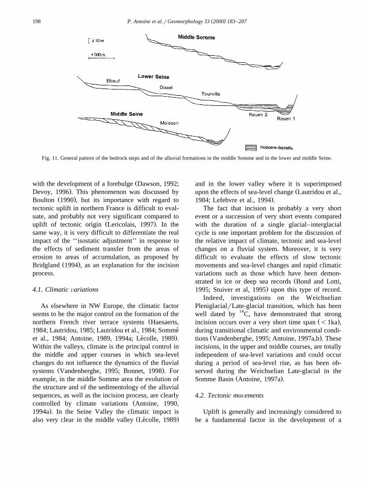
Ž .as the Seine Fig. 11 .Finally, it is also possible that, in northwestern
France tectonic uplift has been enhanced duringglacial stages by glacio-isostatic crustal rebound,
( )P. Antoine et al.rGeomorphology 33 2000 183–207198
Fig. 11. General pattern of the bedrock steps and of the alluvial formations in the middle Somme and in the lower and middle Seine.
Žwith the development of a forebulge Dawson, 1992;.Devoy, 1996 . This phenomenon was discussed by
Ž .Boulton 1990 , but its importance with regard totectonic uplift in northern France is difficult to eval-uate, and probably not very significant compared to
Ž .uplift of tectonic origin Lericolais, 1997 . In thesame way, it is very difficult to differentiate the realimpact of the ‘‘isostatic adjustment’’ in response tothe effects of sediment transfer from the areas oferosion to areas of accumulation, as proposed by
Ž .Bridgland 1994 , as an explanation for the incisionprocess.
4.1. Climatic Õariations
As elsewhere in NW Europe, the climatic factorseems to be the major control on the formation of the
Žnorthern French river terrace systems Haesaerts,1984; Lautridou, 1985; Lautridou et al., 1984; Somme
.et al., 1984; Antoine, 1989, 1994a; Lecolle, 1989 .´Within the valleys, climate is the principal control inthe middle and upper courses in which sea-levelchanges do not influence the dynamics of the fluvial
Ž .systems Vandenberghe, 1995; Bonnet, 1998 . Forexample, in the middle Somme area the evolution ofthe structure and of the sedimentology of the alluvialsequences, as well as the incision process, are clearly
Žcontrolled by climate variations Antoine, 1990,.1994a . In the Seine Valley the climatic impact is
Ž .also very clear in the middle valley Lecolle, 1989´
and in the lower valley where it is superimposedŽupon the effects of sea-level change Lautridou et al.,
.1984; Lefebvre et al., 1994 .The fact that incision is probably a very short
event or a succession of very short events comparedwith the duration of a single glacial–interglacialcycle is one important problem for the discussion ofthe relative impact of climate, tectonic and sea-levelchanges on a fluvial system. Moreover, it is verydifficult to evaluate the effects of slow tectonicmovements and sea-level changes and rapid climaticvariations such as those which have been demon-
Žstrated in ice or deep sea records Bond and Lotti,.1995; Stuiver et al, 1995 upon this type of record.
Indeed, investigations on the WeichselianPleniglacialrLate-glacial transition, which has beenwell dated by 14C, have demonstrated that strong
Ž .incision occurs over a very short time span -1ka ,during transitional climatic and environmental condi-
Ž .tions Vandenberghe, 1995; Antoine, 1997a,b . Theseincisions, in the upper and middle courses, are totallyindependent of sea-level variations and could occurduring a period of sea-level rise, as has been ob-served during the Weichselian Late-glacial in the
Ž .Somme Basin Antoine, 1997a .
4.2. Tectonic moÕements
Uplift is generally and increasingly considered tobe a fundamental factor in the development of a
( )P. Antoine et al.rGeomorphology 33 2000 183–207 199
stepped terrace system as in the middle and lowerŽSeine and middle Somme Rivers cf. Veldkamp and
.Van Den Berg, 1993; Van Den Berg, 1996 .Indeed, in the Somme valley, the progressive and
discontinuous downcutting throughout the whole sys-tem of the middle valley since the end of the LowerPleistocene has taken place in the context of thegeneral uplift of the northwestern part of the Paris
ŽBasin Pommerol, 1978, Colbeaux et al, 1977, 1980,.Antone, 1994a,b . The whole middle Somme valley
is located in an area where uplift rates are uniformŽ .Founiguet, 1987 . All the substantial asymmetricalaggradations of alluvial formations, such as in
Ž .Amiens-Montieres SommerSelle confluence , show`no particular orientation and their development ap-
Žpears to be linked to hydrodynamic processes i.e.,preferential accumulation of fluvial deposits in con-
.fluence zones .In addition, despite numerous observations, no
clear Pleistocene tectonic effects have been recordedŽin the terrace sediments of the middle Somme e.g.,
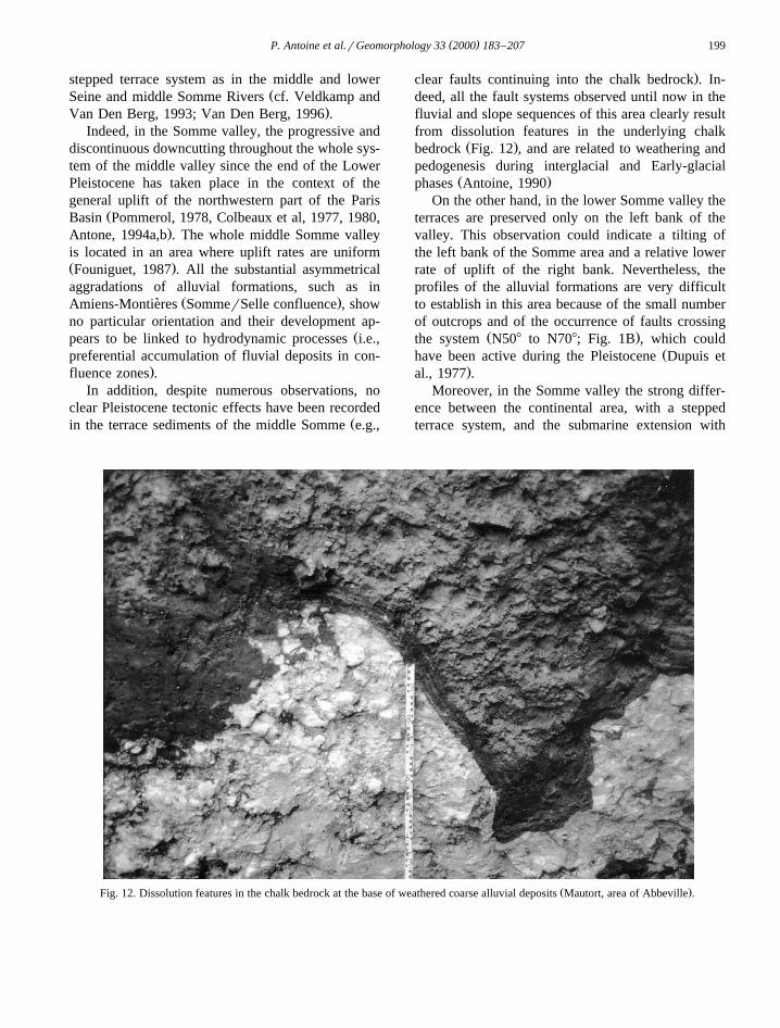
.clear faults continuing into the chalk bedrock . In-deed, all the fault systems observed until now in thefluvial and slope sequences of this area clearly resultfrom dissolution features in the underlying chalk
Ž .bedrock Fig. 12 , and are related to weathering andpedogenesis during interglacial and Early-glacial
Ž .phases Antoine, 1990On the other hand, in the lower Somme valley the
terraces are preserved only on the left bank of thevalley. This observation could indicate a tilting ofthe left bank of the Somme area and a relative lowerrate of uplift of the right bank. Nevertheless, theprofiles of the alluvial formations are very difficultto establish in this area because of the small numberof outcrops and of the occurrence of faults crossing
Ž .the system N508 to N708; Fig. 1B , which couldŽhave been active during the Pleistocene Dupuis et
.al., 1977 .Moreover, in the Somme valley the strong differ-
ence between the continental area, with a steppedterrace system, and the submarine extension with
Ž .Fig. 12. Dissolution features in the chalk bedrock at the base of weathered coarse alluvial deposits Mautort, area of Abbeville .
( )P. Antoine et al.rGeomorphology 33 2000 183–207200
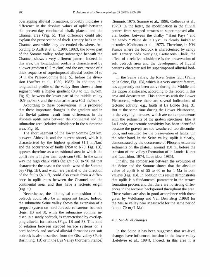
overlapping alluvial formations, probably indicates adifference in the absolute values of uplift betweenthe present-day continental chalk plateau and the
Ž .Channel area Fig. 5 . This difference could alsoexplain the preservation of thick Tertiary beds in theChannel area while they are eroded elsewhere. Ac-
Ž .cording to Auffret et al. 1980, 1982 , the lower partof the Somme valley, today submerged beneath theChannel, shows a very different pattern. Indeed, inthis area, the longitudinal profile is characterised by
Ž .a lower gradient 0.2 mrkm and the occurrence of aŽthick sequence of superimposed alluvial bodies 4 to
. Ž .5 in the Palaeo-Somme Fig. 5 , before the diver-Ž .sion Auffret et al., 1980, 1982 . In addition, the
longitudinal profile of the valley floor shows a shortŽsegment with a higher gradient 0.9 to 1.1 mrkm,
.Fig. 5 , between the lower part of the middle valleyŽ . Ž .0.54mrkm , and the submarine area 0.2 mrkm .
According to these observations, it is proposedthat these important changes in the gradient and inthe fluvial pattern result from differences in theabsolute uplift rates between the continental and the
Žsubmarine area relative subsidence in the submarine.area, Fig. 5 .
ŽThe short segment of the lower Somme 20 km,.between Abbeville and the current shore , which is
Ž .characterised by the highest gradient 1.1 mrkmŽ .and the occurrence of faults N50 to N70, Fig. 1B ,
appears therefore as a transitional area in which theŽ .uplift rate is higher than upstream SE . In the same
Ž .way the high chalk cliffs height : 80 to 90 m thatcharacterise the coast at the south–west of the Somme
Ž .bay Fig. 1B , and which are parallel to the directionŽ .of the faults N508 , could also result from a differ-
ence in uplift rates between the Channel and thecontinental area, and thus have a tectonic originŽ .Fig. 5 .
Nevertheless, the lithological composition of thebedrock could also be an important factor. Indeed,the submarine Seine valley shows the extension of astepped system on hard Jurassic calcareous bedrockŽ .Figs. 1B and 3 , while the submarine Somme, in-cised in a sandy bedrock, is characterised by overlap-
Ž .ping alluvial formations Figs. 1B and 5 . This kindof relation between stepped terrace systems on ahard bedrock and stacked alluvial formations on soft
Žbedrock is also described from the Oise valley Paris. Ž .Basin, Fig. 1B or in the Lys Valley northern France
ŽSomme, 1975, Somme et al., 1996; Colbeaux et al.,´ ´.1979 . In the latter, the modification in the fluvial
pattern from stepped terraces to superimposed allu-vial bodies, between the chalky ‘‘Haut Pays’’ andthe sandy ‘‘Plaine de la Lys’’, is clearly linked to
Ž .tectonics Colbeaux et al., 1977 . Therefore, in NWFrance where the bedrock is characterised by sandysoft Tertiary beds overlying Cretaceous Chalk, theeffect of a relative subsidence is the preservation ofsoft bedrock area and the development of fluvialpatterns characterised by superimposed alluvial bod-ies.
ŽIn the Seine valley, the River Seine fault Faille.de la Seine, Fig. 1B , which is a very ancient feature,
has apparently not been active during the Middle andthe Upper Pleistocene, according to the record in thisarea and downstream. This contrasts with the LowerPleistocene, where there are several indications of
Ž .tectonic activity, e.g., faults at La Londe Fig. 3 .But at the same time during the Lower Pleistocene,in the very high terraces, which are contemporaneouswith the sediments of the graben structures, like atLa Londe, no tectonic sensitivity has been identifiedbecause the gravels are too weathered, too discontin-uous, and unsuited for the preservation of faults. Onthe other hand, in the Seine valley, uplift is clearly,demonstrated by the occurrence of Pliocene estuarinesediments on the plateau, around 150 m, before the
Žincision of the valley Formation of la Londe; Kuntz.and Lautridou, 1974; Lautridou, 1985 .
Finally, the comparison between the evolution ofthe Seine and the Somme shows that the absolutevalue of uplift is of 55 to 60 m for 1 Ma in both
Ž .valleys Fig. 1B . In addition this result demonstratesthat uplift is a fundamental parameter in the terraceformation process and that there are no strong differ-ences in the tectonic background throughout the area.These values are also in good accordance with those
Ž .given by Veldkamp and Van Den Berg 1993 forthe Meuse valley near Maastricht for the same periodŽ .about 70 mr1 Ma .
4.3. Sea-leÕel changes
In the Seine it has been suggested that sea-levelchanges have influenced incision in the lower valleyŽ .Lefebvre et al., 1994 . Indeed, in this area it is
( )P. Antoine et al.rGeomorphology 33 2000 183–207 201
possible to describe more than one glacial–intergla-cial cycle overlying a single bedrock step, such as at
Ž .Tourville Lautridou, 1985; Lautridou et al., 1984 .This pattern indicates that strong incision in thechalk bedrock does not always occur during eachglacial or Early-glacial phase.
The interpretation proposed by Lefebvre et al.Ž .1994 is that the main bedrock steps result fromregressive erosion during the strongest sea-level falls.It has been suggested that the main incision phases
Žin this area may occur during the coldest stages OIS.2, 6 , 12, 16 and 22 .
Nevertheless, the problem with determining theeffect of sea-level change lies with the identificationof the section of the river that has been controlled bythis factor, especially during sea-level fall. More-over, the change in fluvial pattern in response tosea-level fall also depends on the gradient of theplatform exposed by the regression.
In the Seine valley, the boundary between thelower valley, controlled by sea-level changes, andthe middle valley, characterised principally by cli-matic control is marked in the longitudinal profiles
Ž .gradients by a knick point Fig. 2 , and a change inthe longitudinal profile from 0.3–0.5 mrkm in thelower valley to 0.2 mrkm in the middle and upper
Ž .courses Lautridou et al., 1984 .In the Somme Valley, a clear difference is also
Ž .seen between the middle and lower courses Fig. 5 .In the middle course, where the terraces are bestpreserved, the slope of the longitudinal profile is of0.5–0.54 mrkm, whilst in the lower valley, after avery pronounced knick-point near Abbeville, the lon-gitudinal profile of the modern valley bedrockchanges very rapidly and shows a gradient of 1.1
Ž .mrkm from Abbeville y12.5 m to Le HourdelŽ . Žy30ry33 m in the modern estuary Antoine,
.1990 . Then, below the Channel, the gradient is veryŽ .low 0.2 mrkm between the present coast and the
Greenwich deep. In this system, where the incisionin the middle valley is related to Early-glacial condi-
Ž .tions Antoine, 1989, 1990; Antoine et al., 1995 , astrong lowering of sea-level is not necessary tochange the profile, which is completely emerged
Ž .when the sea-level is at y50 m Fig. 5 . Thislowering of the sea-level is solely a condition for theexportation of the sediment produced upstream bythe incision.
According to the model of early and quick inci-sion described above, the absence of a palaeovalley
Žin the western part of the Channel west of the Hurd.Deep , previously interpreted as the result of marine
Ž .erosion during sea-level rise Lericolais, 1997 , couldtherefore be explained only by the absence of fluvialincision. Following this idea, and on the basis of thedata from the last climatic cycle, it is suggested thatall the incision process takes place at the beginning
Ž .of the cycle Early-glacial when the sea-level fallsvery quickly to y20r25 m minimum, as after the
Ž .Eemian Zagwijn, 1989; Somme et al., 1994 , then to´Žy50 to y60m at the end of the Weichselian early
.glacial . When the sea-level was around –50r–60m,incision ended because of the huge increase in coarsesedimentary supply linked to the onset of Pleniglacial
Ž .conditions solifluction . Thus during thePleniglacial, when the sea-level fell up to y130m,the continental area between the Hurd Deep and the
Ž .ocean Fig. 1A is an area of transport or of sedimen-tation but not of incision. Indeed incision is com-pleted, and during the most important part of thePleniglacial the area is characterised by transporta-tion and deposition of coarse sediments. Then duringsea-level rise, at the beginning of a new interglacialstage, these deposits are reworked and eroded bymarine erosion.
Finally, even if it is generally thought that sea-level falls could induce incision in the lower coursesof the fluvial systems, the speed of the phenomenaŽ .1r5 mmryear is very low compared with thespeed of the incision induced by abrupt climatechanges. Therefore, its impact on large fluvial sys-tems is not easy to demonstrate. In addition, in theexample of the Somme, the very low gradient of theeastern part of the Channel could also reduce theimpact of sea-level fall. In the Somme valley, thechanges in the gradient observed in the lower valleyare therefore rather linked to differences in the upliftrates as it was proposed previously in the discussionabout techtonic movements Section 4.2.
5. Conclusion
According to the evidence for evolution of theSeine and Somme river valleys during the last 1 Ma,
( )P. Antoine et al.rGeomorphology 33 2000 183–207202
it appears that climatic variations, tectonic move-ments and sea-level changes have worked together atdifferent timescales and that their relative impact isvariable in the different areas of the fluvial systems.
Nevertheless, combining the data for a long riversystem such as the Seine, it is possible to determinethe principal controls acting on each of the differentparts of the fluvial system. For example, in the SeineValley, a low rate of tectonic uplift during the Pleis-tocene is shown in the whole course by the occur-rence of Pliocene marine and estuarine sediments onthe plateau before the incision of the valley.
According to the data from the Seine and Sommevalleys, climatic and tectonic factors are stronglylinked in the terrace formation processes but work at
Žvery different rates. The slow tectonic uplift 0.05 to.0.06 mmryear is fundamental to create the potential
for incision which is accumulated throughout a cli-matic cycle. This potential is then quickly releasedduring the incision, the speed of which is about 50 to100 times faster than the uplift. This short incisionprocess takes place at the beginning of the climatic
Ž .cycle, in a transitional period Early-glacial , charac-terised by strong seasonal increases in water flow,
Žand by a still well developed vegetation limitation.of the colluvial imput into the valley .
In the lower Seine the main factor seems to besea-level variation and especially sea-level falls dur-ing the coldest glacial periods. On the other hand,the pattern of the middle and upper Seine valleyfluvial systems is mainly controlled by climatic vari-ations superimposed on an uplifting background.
In the Somme valley, the middle and upper coursesare located in the same uplifting area as the Seine.The fluvial pattern of all this area seems to be underclimatic control, as is shown by the study of thealluvial sequences.
The very strong changes in the gradient of thebedrock-profiles, observed at the junction betweenthe middle and lower Somme, then between thelower Somme and the submarine area, are not linkedto the influence of sea-level variations because of thevery low gradient of the submarine profile which isnot very sensitive to sea-level fall.
On the other hand, according to the strong differ-ences that appear in the gradient and in the pattern ofthe fluvial system between the present day continen-tal and submarine area, it is proposed that these two
parts of the system are controlled by different ratesof uplift:
-relatively high uplift rates in the middle andlower valley characterised by a stepped terracesystem and high gradients
Ž .-lower uplift rate relative subsidence in the sub-marine area showing stacked alluvial sequencesand a lower gradient.
Finally, in the same general climatic and tectonicbackground, the difference between the Seine andthe Somme responses during the Pleistocene seemsto be mainly related to:
-differences in the influence of sea-level changes,partly linked to the geometry of the submarine
Žarea gradient of the structural platform, composi-.tion of the bedrock, tectonic evolution and,
-differences in the general pattern of the valleylinked to the size of the fluvial basins, and to
Žhydrodynamic parameters size of the meanders,.sinuosity
The middle Somme valley terrace system repre-sents therefore an intermediate pattern stage betweenthe Middle and the Lower Seine valleys.
It is concluded that the study of the terrace sys-tems appears to be a very good tool for the measure-ment of general tectonic movements during the Pleis-tocene.
Acknowledgements
This work is partly supported by the ‘‘Palaeolithicoccupations and Pleistocene Palaeoenvironments inthe Somme Basin and surrounding areas’’ programŽfunded by the French National Centre for the Scien-
.tific Research .We thank B. Morin and J.M. Dolo for their help
in ESR measurements, and Phil Gibbard and DavidBridgland for the review of the English text and theirconstructive suggestions.
( )P. Antoine et al.rGeomorphology 33 2000 183–207 203
Appendix A. ESR dating of fluvial quartz grainsfrom the Somme Valley alluvial formations
A.1. Introduction
Ž .Electron Spin Resonance ESR dating of sedi-ments may improve our knowledge of the chronos-tratigraphy of the Tertiary and Quaternary periodsand especially in the case of non-calcareous deposits.
ŽQuartz extracted from volcanic materials Shimokawa.et al., 1984 and sediments baked by lava-flows
Ž . ŽYokoyama et al., 1986 or burned by fire Monnier.et al., 1994 have been dated by ESR. Bleaching of
quartz has been studied in Quaternary sedimentsŽYokoyama et al., 1985; Buhay et al., 1988; Li et al.,1993; Brumby and Yoshida, 1994; Laurent et al.,
.1994 , and recently, ESR results have been obtainedon bleached quartz extracted from Tertiary forma-
Ž .tions Laurent et al., 1998 .ESR dating of bleached quartz is based on the
Ž .behaviour of the aluminium centre Al : it is com-posed of an aluminium atom substituted to a silicium
Ž .centre Weil, 1984 . The diamagnetic centrewŽ q.xAlO rM becomes paramagnetic under ionising4
wŽ .x Žradiation AlO rh see details and other references4.in Ikeya, 1993 . Exposure to light releases trapped
electrons which will be collected by an aluminiumhole centre. This process will induce the bleachingphenomena. However, the energy light scale allowsonly a part of trapped electrons, which means thatthe bleaching is incomplete.
In order to date quartz, it is important to deter-mine residual intensity after light bleaching. Moderncoast or overbank sands have a constant ESR inten-sity after a very long exposure under UV-light; fossilsands and irradiated modern sands show decreasingintensity under UV-light. The latter tend to reachtheir natural intensity. The Al centre in quartz reachesa residual level which corresponds to the maximumof bleaching. Dating of quartz extracted from sedi-ment requires samples that were exposed to sunlightfor long times in the range of 6 months.
For fossil quartz, the maximal bleaching intensityis calculated by a least square method fitted by an
Žexponential decay added to a constant value Walther.and Zilles, 1994 :
f x saeyb x qcŽ .
The palaeodose, P, is determined by fitting thedose response curve with a simple saturating func-tion and extrapolation to the residual intensity.
Appendix B. Sampling and method
Each sample consists of about 400 g of sedimentenclosed in an opaque bag. The water content ofeach sample was determined by drying the sedimentat 408C.
Quartz was extracted according to the usual chem-ical methods already described by Yokoyama et al.Ž .1985 . Gamma-ray irradiations are made with a
Ž .cobalt panoramic source Dolo et al., 1996 ; tenaliquots were irradiated with the same dose flow.The range of 10 doses were chosen between 1000 Gand 15,000 Gy. Palaeodose measurements were cal-culated using the least squares method equation and
Ž .error measurement Yokoyama et al., 1985 . TheŽquartz was exposed to UV-light UV lamp with a
.wavelength in the range 365–400 nm . The U, Ra,Rn, Th and K activities of the sediments were deter-mined using gamma-ray spectrometry. A k-value of0.15 " 0.10 was assumed, alpha and beta attenua-tions in quartz were estimated from the calculations
Ž . Ž .of Mejdahi 1979 and Bell 1980 . Cosmic doseswere then calculated using the formula of Yokoyama
Ž .et al. 1981 .Measurement errors are due to gamma dosimetry,
intensity height determination of the Al centre, ra-dioelement content counting and moisture content.The analytical results are given in Table 1.
References
Alduc, D., Auffret, J.P., Carpentier, G., Lautridou, J.P., Lefebvre,D., Porcher, M., 1979. Nouvelles donnees sur le Pleistocene´ ´ `de la basse vallee de la Seine et son prolongement sous-marin´en Manche orientale. Bull. Ass. Geol. Bass. Par. 16, 27–34.
Antoine, P., 1989. Les terrasses quaternaires du bassin de laSomme: Etude geologique et geomorphologique, contribution´ ´a la connaissance du Paleoenvironnement des gisements` ´paleolithiques, These de Doctorat, Univ. des Sciences et Tech-´ `nologies de Lille, 437 pp.
Antoine, P., 1990. Chronostratigraphie et Environnement duPaleolithique du bassin de la Somme. Publ. du Centre d’Etudes´
Ž .et de Recherches Prehistoriques CERP 2, 231 pp.´
( )P. Antoine et al.rGeomorphology 33 2000 183–207204
Antoine, P., 1993. Le systeme de terrasses du Bassin de la`Somme: modele d’evolution morphosedimentaire cyclique et` ´ ´cadre paleoenvironnemental pour le Paleolithique. Quaternaire´ ´Ž .4 1 , 3–16.
ŽAntoine, P., 1994a. The Somme Valley terrace system Northern.France ; a model of river response to quaternary climatic
variations since 800,000 BP. Terra-Nova 6, 453–464.Antoine, P., 1994b. Rapport sur l’operation de suivi de travaux A´
Ž .16-Montieres Somme . Rapport d’etude CNRSrAFANr` ´Service Regional de l’Archeologie de Picardie, 44 pp.´ ´
Antoine, P., 1997a. Modifications des systemes fluviatiles a la` `transition Pleniglaciaire–Tardiglaciaire et a l’Holocene: l’ex-´ ` `
Ž .emple du bassin de la Somme Nord de la France . Geog. Phy.Ž .Quat. 51 1 , 93–106.
Antoine, P., 1997b. Evolution tardiglaciaire et debut Holocene des´ `vallees de la France septentrionale: nouveaux resultats. Compte´ ´Rendus de L’Academie des Sciences, Sciences de la Terre et´des Planetes Paris 325, 35–42.`
Ž .Antoine, P. Ed. , 1998 Le Quaternaire de la vallee de la Somme´et du littoral picard, Livret-guide de l’Excursion de l’Associa-
´tion Francaise pour l’Etude du Quaternaire dans le bassin de laSomme, 162 pp.
Antoine, P., Munaut, A.V., Somme, J., 1994. Reponse des envi-´ ´ronnements a l’evolution climatique du Debut Glaciaire we-` ´ ´ichselien: donnees de la France du Nord Ouest. Quaternaire 5,´ ´151–156.
Antoine, P., Munaut, A.V., Van Kolfshoten, Th., Limondin, N.,1995. Une occupation du Paleolithique moyen en milieu fluvi-´atile dans la sequence de la tres basse terrasse de la Somme a´ ` `
Ž . Ž .Saint Sauveur Somme . Bull. Soc. Prehist. Fr., T. 92 2 ,´201–212.
Antoine, P., Lautridou, J.P., Somme, J., Auguste, P., Auffret, J.P.,´Baize, S., Clet-Pellerin, M., Coutard, J.P., Dewolf, Y., Dugue,´O., Joly, F., Laignel, B., Laurent, M., Lavolle, M., Lebret, P.,´Lecolle, F., Lefebvre, D., Limonini Lozouet, N., Munaut,´A.V., Ozouf, J.C., Quesnel, F., Rousseau, D.D., 1998. Lequaternaire de la France du Nord-Quest: limites et correla-´tions. Quaternaire 9, 227–241.
Antoine, P., Rousseau, D.D., Lautridou, J.P., Hatte, C., 1999. In:´The last interglacial–glacial cycle in loess–palaeosol succes-sions of northwestern France Boreas, 28 551–563.
Antoine, P., Tuffreau, A., 1993. Contexte stratigraphique, clima-tique et paleotopographique des occupations acheuleennes de´ ´la moyenne terrasse de la Somme. Bull. Soc. Prehist. Fr., T. 4,´243–250.
Auffret, J.P., Alduc, D., Larsonneur, C., Smith, A.J., 1980. Car-tographie du paleoreseau des paleovallees et de l’epaisseur des´ ´ ´ ´ ´formations superficielles meubles de la Manche orientale.Ann. Inst. Oceanogr., Paris 56, 21–35.
Auffret, J.P., Horn, R., Larsonneur, C., Curry, D., Smith, A.J.,1982. La Manche orientale, carte des paleovallees et des bancs´ ´sableux. BRGM edit.
Auguste, P., 1995. Revision preliminaire des grands mammiferes´ ´ `des gisements du Paleolithique inferieur et moyen de la vallee´ ´ ´
Ž .de la Somme. Bull. Soc. Prehist. Fr. 92 2 , 143–154.Balescu, S., 1988. Apports de la thermoluminescence a la strati-`
graphie et a la sedimentologie des loess du Nord-Ouest de` ´
l’Europe. These Doct. Scien. Univ. Bruxelles, Vol I: 199 pp.,`Vol II: annexes, 144 pp.
Balescu, S., Lamothe, M., Lautridou, J.P., 1997. Luminescenceevidence for two Middle Pleistocene interglacial events at
Ž .Tourville, north-western France. Boreas 26 1 , 61–72.Balescu, S., Packman, S.C., Wintle, A.G., 1991. Chronological
separation of interglacial raised beaches from northwesternEurope using thermoluminescence. Quat. Res. 35, 91–102.
Bates, M., 1993. Quaternary aminostratigraphy in NorthwesternFrance. Quat. Sci. Rev. 12, 793–809.
Bell, W.T., 1980. Alpha dose attenuation in quartz grains forthermoluminescence dating. Ancient TL 12, 4–8.
Biquand, D., 1974. Position chronologique de la tres haute nappe`alluviale de Grace vallee de la Somme par rapport a la limiteˆ ´ `paleomagnetique Bruhnes-Matuyama. Bull. Ass. Fr. Et. Quat.´ ´11, 157–159.
Bond, G., Lotti, R., 1995. Iceberg discharge into the NorthAtlantic in millenial time scales during the last glaciation.Science 267, 1005–1010.
Bonnet, S., 1998. Tectonique et dynamique du relief: le soclearmoricain au Pleistocene. Mem. Geosci. Rennes 86, 352 pp.´ `
Bordes, F., 1954. Les limons quaternaires du bassin de la Seine.Arch. Inst. Paleontol. Hum., Mem. 26, 472 pp.
Boulton, G.S., 1990. Sedimentation and sea-level change duringglacial cycles and their control on glacimarine facies architec-
Ž .ture. In: J.A., Scourse, J.D. Eds. , Glacimarine Environments:Processes and Sediments. Dowdeswell, Geo. Soc. London,Spec. Publ. 53, 15–52.
Bourdier, F., 1969. Excursion dans le bassin de Paris de l’Associa-tion Internationale pour l’Etude du Quaternaire du 18 au 28aout 1969: etude comparee des depots quaternaires des bassinsˆ ´ ´ ˆde la Seine et de la Somme. Bull. Inf. Geol. Bassin Paris 21,169–220.
Bourdier, F., 1984. Essai d’historique sur la notion de nappesalluviales periglaciaires. Bull. Ass. Fr. Et. Quat. 21, 5–7.´
Bourdier, F., Chaline, J., Munaut, A.V., Puissegur, J.J., 1974a. Latres haute nappe alluviale de la Somme. Bull. Ass. Fr. Et.`Quat. 11, 137–143.
Bourdier, F., Chaline, J., Munaut, A.V., Puissegur, J.J., 1974b. LeComplexe mindelien: II-La moyenne terrasse de l’Avre Bull.Ass. Fr. Et. Quat. 11, 168–180.
Breuil, H., Koslovsky, L., 1931. Etudes de stratigraphiepaleolithique dans le Nord de la France, la Belgique et´l’Angleterre. Anthropologie 41, 249–290.
BRGM, 1996. Carte Geologique de la France a l’echelle du´ ` ´millionieme.. Bureau de Recherches Geologiques et Minieres ,` ´ `Orleans.´
Bridgland, D.R., 1994. Quaternary of the Thames, GeologicalConservation Review Series. Chapman & Hall, London, 441pp.
Brumby, S., Yishida, H., 1994. An investigation of the effect ofsunlight on the ESR spectra of quartz centers: implications fordating. Quat. Sci. Rev. 13, 615–618.
Brunnacker, K., Lohr, H., Boenick, W., Puissegur, J.J., Poplin, F.,1975. Quartar-Aufschlusse bei Ariendorf am Unteren Mittel-¨ ¨rhein. Mainzer Naturwiss. Archi. 14, 93–141.
Brunnacker, K., Loscher, M., Tillmans, W., Urban, B., 1982.¨
( )P. Antoine et al.rGeomorphology 33 2000 183–207 205
Correlation of the Quaternary terrace sequence in the LowerRhine valley and Northern Alpine foothills of central Europe.Quat. Res. 18, 152–173.
Buhay, W.M., Schwarczs, H.P., Grun, R., 1988. ESR dating of¨fault-gouge: the effect of grain size. Quat. Sci. Rev. 7, 515–522.
Clet-Pellerin, M., 1983. Le Plio-Pleistocene en Normandie. Ap-´ `ports de la Palynologie. These 3 cycle. Univ. Caen, 135 pp.`
Colbeaux, J.P., Beugnies, A., Dupuis, Ch., Robasynski, F.,Somme, J., 1977. Tectonique de Blocs dans le Sud de la´Belgfique et le Nord de la France. Ann. Soc. Geol. Nord. 97,191–222.
Colbeaux, J.P., Dupuis, Ch., Robasynski, F., Auffret, J.P., Hae-saerts, P., Somme, J., 1980. Le Detroit du Pas-de-Calais: un´ ´element dans la tectonique de blocs de l’Europe Nord-Occi-´ ´dentale. Bull. Inf. Geol. Bassin Paris 17, 41–54.
Colbeaux, J.P., Leplat, J., Paepe, R., Somme, J., 1978. Tectonique´recente dans le Nord de la France et le Sud de la Belgique:´
Žexemple de la Plaine de la Lys Feuille Hazebrouck, 1r50.000 . Ann. Soc. Geol. Nord. 98, 179–188.
Colbeaux, J.P., Somme, J., Tuffreau, A., 1979. Tectonique quater-´naire dans le Nord de la France: l’apport du gissement deBiache-Saint-Vaast. Bull. Ass. Fr. Et. Quat. 2s 7–8, 183–192.
Commont, V., 1909. Saint-Acheul et Montieres. Notes de Geolo-` ´gie, de Paleontologie et de Prehistoire. Mem. Soc. Geol. Nord.´ ´T6, 3, 68 pp.
Commont, V., 1910. Excursion de la Societe geologique du Nord´ ´ ´et de la Faculte des Sciences de Lille a Abbeville, le 11 juin´ `1910. Les gisements paleolithiques d’Abbeville. Stratigraphie,´faune, industrie humaine. Situation par rapport aux terrassesfluviatiles de la Somme. Ann. Soc. Geol. Nord. 39, 249–293.´
Commont, V., 1911. Les gisements prehistoriques de Saint-Acheul´et de Montieres. Notes de Prehistoire publiees dans le Bulletin` ´ ´de la Societe Lineenne du Nord de la France de 1905 a 1910.´ ´ ´ `Amiens, 189 pp.
Cordy, J.M., 1989. Les micromammiferes de Cagny-l’Epinette`Ž .rapport preliminaire . In: Livret-guide de l’excursion dans la´vallee de la Somme. Colloque L’Acheuleen dans l’Ouest de´ ´l’Europe, Saint-Riquier, juin 89, 80–81.
Dawson, A.G., 1992. Ice Age Earth: Late Quaternary Geologyand Climate. Routledge, London.
Devoy, R., 1996. Deglaciation, Earth crustal behaviour and sea-level changes in the determination of insularity: a perpective
Ž .from Ireland. In: Preece, R.C. Ed. , Island Britain: a Quater-nary Perspective. Geo. Soc. Spe. Publ. 96, 181–208 pp.
Dolo, J.M., Lecerf, N., Mihajlovic, V., Falgueres, C., 1996.Contribution of ESR dosimetry for irradiation of geologicaland archaeological samples with a 60Co panoramic source.Applied Radiation and Isotopes 47, 1419.
Dupuis, Ch., Haesaerts, P., Heinzelin, J., 1977. Mise en evidence´de depots a caractere fluvio-marin parmi les nappes alluviales´ ˆ ` `de la Basse Somme. Bull. Ass. Fr. Et. Quat. 14, 86–95.
Durbet, G., Rodriguez, P., Badalian, L., Djillali, H., Gautier, A.,Laurent, M., Ricard, J.L., Watez, J., 1997. Decouverte d’un´site paleolithique moyen dans les alluvions saaliennes du´
Ž .confluent Seine-Marne a Maison-Alfort Val de Marne . C. R.`Ž .Acad. Sci., Paris 324, serie IIa, 505–512.´
Engelmann, A., Frechen, M., 1998. Datations TLrIRSL. In:Ž .Antoine, P. Ed. , Le Quaternaire de la vallee de la Somme et´
du littoral picard, Livret-guide de l’Excursion de l’Association´Francaise pour l’Etude du Quaternaire dans le bassin de la
Somme. 41–42.Founiguet, J., 1987. Geodynamique actuelle dans le Nord et le´
Nord-Est de la France. Apport des comparaisons de nivelle-ments. Mem. BRGM 127, 173.
Gibbard, P.L., 1988. The History of the great northwest Europeanrivers during the past three million years. Philo. Trans. R. Soc.London 318, 559–602.
Haesaerts, P., 1984. Les formations fluviatiles pleistocenes duBassin de la Haine Belgique. Bull. Ass. Fr. Et. Quat. 21,19–26.
Haesaerts, P., Dupuis, Ch., 1986. Contribution a la stratigraphie`des nappes alluviales de la Somme et de l’Avre dans la region´d’Amiens. Bull. Ass. Fr. Et. Quat. 26, 171–186.
Ikeya, M., 1993. New Applications of Electron Spin Resonance:Dating, Dosimetry and Microscopy. World Scientific Publish-ing, 500.
Kuntz, G., Lautridou, J.P, 1974. Contribution a l’etude du Pliocene` ´ `et du passage Pliocene–Quaternaire dans les depots de la Foret` ´ ˆ ˆde la Londe, pres de Rouen Correlations possibles avec divers` ´gisements de Haute-Normandie. Bull. Ass. Fr. Et. Quat. 3–4,117–128.
Laurent, M., 1993. Datation par resonance de spin electronique´ ´Ž .ESR de quartz de formations quaternaires: comparaison avecle paleomagnetisme. These Doct. Museum Nat. Hist. Nat.,´ ´ `Paris, 103 p., 39 figures, 2 tables.
Laurent, M., Falgueres, C., Bahain, J.J., Yokoyama, Y., 1994.Geochronologie du systeme de terrasses quaternaires fluvi-´ `atiles du bassin de la Somme. Comptes Rendus de l’Ac. desSc. Paris, Ser. IIa, t. 318, 521–526.´
Laurent, M., Falgueres, C., Bahain, J.J., Rousseau, L., vliet-Lanoe,B., 1998. ESR dating of quartz extracted from Quaternary andNeogene sediments: method, potential and actual limits. Quat.Geochronol. 17, 1057–1062.
Ž .Lautridou, J.P., Ed. , 1982. The Quaternary of Normandy. Bull.Centre de Geom. , CNRS, Caen., 26, 88 pp.´
Lautridou, J.P., 1985. Le cycle periglaciaire pleistocene en Europe´ ´ `du Nord-Quest et plus particulierement en Normandie. These` `Lettres, Univ. Caen, 2 vol, 908 pp.
Lautridou, J.P., Lefebvre, D., Lecolle, F., Carpentier, G., De-´scombes, J.C., Gaquerel, C., Hault, M.F., 1984. Les Terrassesde la Seine dans le meandere d’Elbeuf, correlatrions avec´ ´celles de la region de mantes. Bull. Ass. Fr. Et. Quatern. 1–3,´27–32.
Lautridou, J.P., Auffret, J.P., Lecolle, F., Lefebvre, D., Lericolais,´G., Roblin-Jouve, A., Balescu, S., Carpentier, G., Cordy, J.M.,Descombes, J.C., Occhietti, S., Rousseau, D.D., 1999. Lefleuve Seine Le fleuve Manche. Bull. Soc. Geol. Fr. 170,545–558.
Lecolle, F., 1989. Le cours moyen de la Seine au Pleistocene´ ´ `moyen et superieur. Geologie et Prehistoire. These d’Etat,´ ´ ´ `
Ž .Univ. Paris VI 1987 . Groupe Seine, Lab. Geol. Univ. Rouen,´549 pp.
Lecolle, F., Rousseau, D.D., Lautridou, J.P., Puissegur, J.J., Oc-´ ´
( )P. Antoine et al.rGeomorphology 33 2000 183–207206
chietti, S., Quinif, Y., 1990. Le tuf de Vernon: nouvellesŽdonnees stratigraphie, paleoclimatologie, datations, correla-´ ´ ´
.tions . Bull. Cent. Geomorphol CNRS Caen 38, 131–150.Lefebvre, D., Antoine, P., Auffret, J.P., Lautridou, J.P., Lecolle,´
F., 1994. Rythme de reponse des environnements fluviatiles´aux changements climatiques en France du Nord-Ouest. Qua-
Ž .ternaire 5 , 3–4, 165–172.´Lericolais, G., 1997. Evolution Plio-quaternaire du Fleuve Manche:
Stratigraphie et Geomorphologie d’une plateforme continen-´tale en regime periglaciaire. These Doct. Geol. marine, Univ.´ ´ ` ´Bordeaux I, 265 pp.
Li, D., Gao, H., Ding, Z., Zhao, X., Yang, B., 1993. On theestimation of depositional ages of loess by ESR. Appl. Radiat.Isot. 44, 203–206.
Limondin, N., 1995. Late-Glacial and Holocene malacofaunasfrom archaeological sites in the Somme Valley, North France.J. Archaeol. Sci. 22, 683–698.
Lowe, J.J., Walker, M.J.C., 1984. Reconstructing QuaternaryEnvironments. Longman, New York, 389 pp.
Maddy, D., 1997. Uplift-driven valley incision and river terraceformation in Southern England. J. Quat. Sci. 12, 539–545.
Martinson, D.G., Pisia, N.G., Hays, J.D., Imbrie, J., Moore, T.C.,Shackleton, N.J., 1987. Age dating and the orbital theory ofthe Ice ages: development of a high-resolution 0 to 300,000-year chronostratigraphy. Quat. Res. 27, 1–29.
Mejdahj, V., 1979. Thermoluminescence dating: beta-dose attenu-ation in quartz grains. Archaeometry 21, 61–72.
Moigne, A.M., 1989. Cagny-l’Epinette: la grande faune. In:Livret-guide de l’excursion dans la vallee de la Somme,´Colloque L’Acheuleen dans l’Ouest de l’Europe. Saint-Riquier,´82–87.
Monnier, J.l., Hallegouet, B., Hinguant, S., Laurent, M., Auguste,P., Bahain, J.J., Gebhardt, A., Falgueres, C., Marguerie, D.,Molines, N., Morzadec, H., Yokoyama, Y., 1994. A new
Ž .regional group of the Lower Palaeolithic in Brittany France ,recently dated by Electron Spin Resonance. Compte Rendus
Ž .Acad. Sci., Paris, S IIa 319 , 155–160.Munaut, A.V., 1988. L’environnement vegetal de quelques depots´ ´ ´ ˆ
quaternaires du bassin de la Somme. Cultures et industriespaleolithiques en milieu loessique, Amiens, dec. 86. Rev.´ ´Archeol. Picardie., 1–2, 45–56.´
Munaut, A.V., 1989. Cagny-l’Epinette: analyses palynologiques.In: Livret-guide de l’excursion dans la vallee de la Somme.´Colloque L’Acheuleen dans l’Ouest de l’Europe. Saint-Riquier,´juin 1989, 75–79.
Munaut, A.V., 1998. Synthese de l’evolution de la vegetation au` ´ ´ ´Ž .Tardiglaciaire et a l’Holocene. In: Antoine, P. Ed. , Le Qua-` `
ternaire de la vallee de la Somme et du littoral picard,´Livret-guide de l’Excursion de l’Association Francaise pour
´l’Etude du Quaternaire dans le bassin de la Somme, 84–87.Munaut, A.V., Defgnee, A., 1997. Biostratigraphie et environ-´
nement vegetal des industries du Tardiglaciaire et du debut de´ ´ ´l’Holocene dans le bassin de la Somme. CTHS Edit., Le`Tardiglaciaire en Europe du Nord-Ouest, J.P. Fagnart et A.Thevenin dir., 27–37.´
Pomerol, C., 1978. Evolution paleogeographique et structurale du´ ´Bassin de Paris, du Precambrien a l’actuel, en relation avec les´ `
Ž .regions avoisinantes. Geol. Mijnbouw 57 4 , 533–543.´
Prestwich, J., 1859. On the occurence of flint implements associ-ated with remains of animals of extinct species in beds of alate geological period in France at Amiens and Abbevillle andin England at Hoxne. Philos. Trans. R. Soc. London 150,277–327.
Roblin-Jouve, A. , Rodriguez, P., 1997. Paleogeographie des´ ´occupatuions humaines du centre du Bassin parisien a partir`du Tardiglaciaire. In CTHS Edit., Le Tardiglaciaire en Europedu Nord-Ouest, CTHS Ed., J.P. Fagnart et A. Thevenin dir.,´141–150.
Rousseau, D.D., 1987. Les associations malacologiques des tufsholsteiniens de la France septentrionale Une application duconcept de biome. Bull. Cent. Geomor. CNRS Caen 37, 9–18.
Rousseau, D.D., Puissegur, J.J., Lecolle, F., 1992. West-European´ ´Žterrestrial molluscs assemblages of isotopic stage 11 Middle
.Pleistocene : climatic implications. Palaeogeogr., Palaeoclima-tol., Palaeoecol. 92, 15–19.
Schumm, S.A., 1977. The Fluvial System. Wiley, New York, 338pp.
Shimokawa, K., Imai, N., Hirota, M., 1984. Dating of a volcanicrock by ESR. Isot. Geosci. 2, 365–373.
Somme, J., 1975. Les plaines du Nord de la France et leur´bordure. Etude geomorphologique. These Doctorat Etat, Paris´ `I, 810 pp, 185 fig.
Somme, J., Tuffreau, A., 1978. Historique des recherches sur le´Quaternaire de la region du Nord de la France. Bull. Ass. Fr.´Et. Quat. 15, 5–13.
Somme, J., Fagnart, J.P., Leger, M., Munaut, A.V., Puissegur,´ ´J.J., Tuffreau, A., 1984. Terrasses fluviatiles du Pleistocene´ `moyen en France septentrionale: signification dynamique etclimatique. Bull. Ass. Fr. Et. Quat. 21, 52–58.
Somme, J., Tuffreau, A., Aitken, M. J., Auguste, P., Chaline, J.,´Colbeaux, J.P., Cunat-Boge, N., Geeraerts, R., Hus, J.,´Huxtable, J., Juvigne, E., Munaut, A.V., Occhietti, S., Pichet,´P., Puissegur, J.J., Rousseau, D.D., Van Vliet-Lanee, B., 1988.´ ¨Chronostratigraphie, climats et environnements. In: Le Gise-
Žment Paleolithique moyen de Biache-Saint-Vaast Pas de´. Ž .Calais vol I. Tuffreau, A., Somme, J. Eds. , Mem. Soc.´
Prehist. Fr. Vol. 21 pp. 115–119.Somme, J., Munaut, A.V., Etmontspohl, A.F., Limondin, N.,´
Lefebvre, D., Cunat-Boge, N., Mouthon, J., Gilot, E., 1994.´The Watten boring: an Early Weichselian and Holocene cli-matic and paleoecological record from the French North-Seacoastal plain. Boreas 23, 231–243.
Somme, J., Munaut, A.V., Puissegur, J.J., Cunat-Boge, N., Hey-´ ´ ´vaert, F., Leplat, J., 1996. L’Eemien sous les formations
Žweichseliennes et holocenes du sondage d’Erquinghem Nord`. Ž .de la France dans la plaine de la Lys. Quaternaire 7 1 ,
15–28.Stuiver, M., Grootes, P.M., Brazunias, T.F., 1995. The GISP 2
18 O Climate Record of the Past 16 500 Years and the Role ofthe Sun, Ocean, and Volcanoes. Quat. Res. 44, 341–354.
Tourenq, J., Pomerol, C., 1995. Mise en evidence par la presence´ ´d’augite du Massif Central, de l’existence d’une pre Loire -´pre Seine coulant vers la Manche au Pleistocene. C. R. Acad.´ ´ `
Ž . Ž .Sci., Paris 320 IIa , 1163–1169.Tuffreau, A., 1987. Le Paleolithique inferieur et moyen du Nord´ ´
Ž .de la France Nord, Pas-de-Calais, Picardie dans son cadre
( )P. Antoine et al.rGeomorphology 33 2000 183–207 207
stratigraphique. These de doctorat d’Etat, Univ. Sciences et`Techniques de Lille Flandres-Artois, 609 pp.
Tuffreau, A., Antoine, P., 1995. The Earliest occupation of Eu-rope: Continental Northwestern Europe. In: Roebroeks, W.,
Ž .VanKolfshoten, T. Eds. , The Earliest occupation of pleis-tocene Europe. University of Leiden, Leiden, 147–163.
Van Den Berg, M.W., 1996. Fluvial sequences of the Maas : a10ma record of neotectonics and climatic changes. ThesisUniversity of Wageningen, 181 pp.
Vandenberghe, J., 1993. Changing fluvial processes under chang-ing periglacial conditions. Z. Geomorphol N.F. 88, 17–28.
Vandenberghe, J., 1995. Timescales, climate and river develop-ment. Quat. Sci. Rev. 14, 631–638.
Vandenberghe, J., Kasse, C., Bohnke, S., Kozarsky, S., 1994.Climate-related river activity at the Weichselian-Holocenetransition: a comparative study of the Warta and Maas rivers.Terra Nova 6, 476–485.
Vandenberghe, J., Mucher, H.J., Roebroeks, W., Gemke, D.,1985. Lithostratigraphy and palaeoenvironment of the Pleis-tocene deposits at Maastricht-Belvedere, Southern Limburg,´ `the Netherlands. Analecta Praehist. Leidensia 18, 7–18.
Veldkamp, A., Van Den Berg, M.W., 1993. Three-dimentionalmodelling of Quaternary fluvial dynamics in a climo-tectonic
Ždependant system. A case study of the Maas record Maastricht,.The Netherlands . Global Planet. Change 8, 203-218.
Walther, R., Zilles, D., 1994. ESR studies on bleached sedimen-tary quartz. Quat. Geochronol. 13, 611–614.
Weil, J.A., 1984. A review of electron spin spectroscopy and itsapplication to the study of paramagnetic defects in crystallinequartz. Phys. Chem. Miner. 10, 149–165.
Yokoyama, Y., Falgueres, C., Quaegebeur, J.P., 1985. ESR datingof quartz from Quaternary sediments: first attempt. Nucl.
Ž .Tracks 10 4–6 , 921–928.Yokoyama, Y., Falgueres, C., Quaegebeur, J.P., 1986. ESR dating
of sediment baked by lava-flows: comparison of paleodosesŽ .for Al and Ti centers. In: Ikeya, Miki Ed. , ESR dating and
dosimetry. IONICS, Tokyo, 197–204.Yokoyama, Y., Quaegebeur, J.P., Bibron, R., Leger, C., Nguyen,´
Ž .H.V., Popeau, G., 1981. Electron spin resonance ESR datingof bones of the Caune de l’Arago at Tautavel. In: Lumley,
Ž .H.de., Labeyrie, J. Eds. , Absolute Dating and Isotope Analy-ses in Prehistory-Methods and Limits. CNRS, Paris, 457–492.
Zagwijn, W.H., 1989. Vegetation and climate during warmerintervals in the Late Pleistocene of Western and CentralEurope. Quat. Int. 3–4, 57–67.