Embed Size (px)
Citation preview

2035 Long Range Transportation Plan
Decatur Urbanized Area Transportation Study Page i
i An Update to Decatur Pathways 2030
The Long Range Transportation Plan
for the
Decatur Urbanized Area Transportation Study (DUATS)
Long Range Transportation Plan 2035
December 2009
Prepared by:
City of Decatur
Economic & Urban Development Department
The Lead Agency for the
Decatur Urbanized Area Transportation Study
#1 Gary K. Anderson Plaza
Decatur, Illinois 62523
In cooperation with:
City of Decatur
County of Macon
Decatur Park District
Decatur Public Transit System
Illinois Department of Transportation
Federal Highway Administration
Federal Transit Administration
Macon County Highway Department
Village of Forsyth
Village of Mt. Zion
This document was prepared by Mark Smith, DUATS Study Director, Joselyn Stewart, Transportation
Planner, Vasudha Pinnamaraju, Neighborhood Planner, and Brad Boesdorfer, GIS System Analyst, who
wish to acknowledge the substantial input and support provided by the member entities of DUATS and our
transportation planning partners who include the Federal Highway Administration, Federal Transit
Administration and Illinois Department of Transportation.
This LRTP project was partially funded and fully supported by the Federal Highway Administration,
Federal Transit Administration, Illinois Department of Transportation and member entities of DUATS.

2035 Long Range Transportation Plan
Decatur Urbanized Area Transportation Study Page ii
ii Table of Contents
Chapter 1. Introduction ............................................................................................... 1
Chapter 2. Goals and Objectives ..............................................................................11
Chapter 3. Existing Conditions ..................................................................................19
Chapter 4. Future Challenges and Opportunities ..................................................79
Chapter 5. System Safety ............................................................................................84
Chapter 6. System Security ........................................................................................88
Chapter 7. Environmental Mitigation ..................................................................... 94
Chapter 8. Operations and Management...............................................................101
Chapter 9. Public Participation................................................................................107
Chapter 10. Human Services Transportation Planning .......................................116
Chapter 11. Future Conditions and Infrastructure Needs ...................................125
Chapter 12. Financial Capacity and Analysis ........................................................170
Chapter 13. Recommendations .................................................................................194
Appendices ....................................................................................................................213
Public Outreach and Comments
2035 Long Range Transportation Plan
Decatur Urbanized Area Transportation Study Page iii
iii
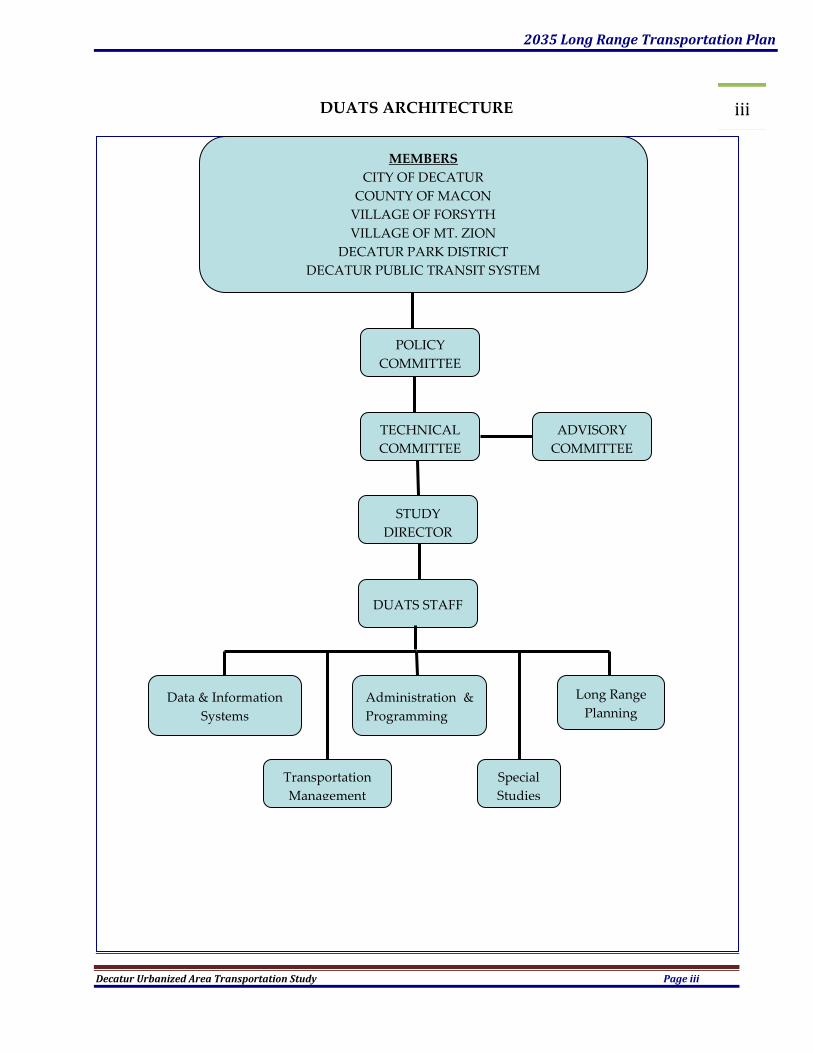
DUATS ARCHITECTURE
MEMBERS
CITY OF DECATUR
COUNTY OF MACON
VILLAGE OF FORSYTH
VILLAGE OF MT. ZION
DECATUR PARK DISTRICT
DECATUR PUBLIC TRANSIT SYSTEM
ILLINOIS DEPARTMENT OF TRANSPORTATION
VILLAGE OF FORSYTH
VILLAGE OF MT. ZION
DECATUR PARK DISTRICT
DECATUR PUBLIC TRANSIT SYSTEM
ILLINOIS DEPARTMENT OF TRANSPORTATION
POLICY
COMMITTEE
TECHNICAL
COMMITTEE
STUDY
DIRECTOR
DUATS STAFF
Data & Information
Systems
Long Range
Planning
Transportation
Management
ADVISORY
COMMITTEE
Administration &
Programming
Special
Studies

2035 Long Range Transportation Plan
Decatur Urbanized Area Transportation Study Page iv
iv DECATUR URBANIZED AREA TRANSPORTATION STUDY
POLICY COMMITTEE
Michael McElroy Mayor, City of Decatur (Chairman)
Don Robinson Mayor, Village of Mt. Zion (Vice Chairman)
Harold Gilbert Mayor, Village of Forsyth
Jay Dunn Chairman, Macon County Board
Roger Driskell Regional Engineer, IDOT, Region 4
TECHNICAL COMMITTEE
Bruce Bird County Engineer, Macon County Highway Department (Chair)
Richard Marley Director, Decatur Dept. of Public Works (Vice Chair)
Mark Smith Senior Planner, Decatur Economic and Urban Development Department
J. L. Potts Village Administrator, Village of Mt. Zion
Paul McChancy Transit Administrator, Decatur Public Transit System
William Clevenger Executive Director, Decatur Park District
-Vacant- Village Administrator, Village of Forsyth
Tim Hemmen Programming Engineer, IDOT, District 7
Matt Newell City Engineer, Decatur Department of Engineering and Infrastructure
Joselyn Stewart Transportation Planner, Decatur Economic and Urban Development Dept
Tony Van Natta Director, Macon County Department of Planning & Zoning
Jerry Potts Chairman, Transportation Committee, Macon County Board
ADVISORY COMMITTEE
Tom Kelso IDOT, Office of Planning & Programming, MPO Manager
J. D. Stevenson FHWA, Illinois Division, Planning and Environment Team Leader
Vanessa Adams FTA, Program Development Officer
STAFF
Mark Smith Study Director
Joselyn Stewart Transportation Planner
Vasu Pinnamaraju Environmental Planner
Brad Boesdorfer GIS Systems Analyst
2035 Long Range Transportation Plan
Decatur Urbanized Area Transportation Study Page v
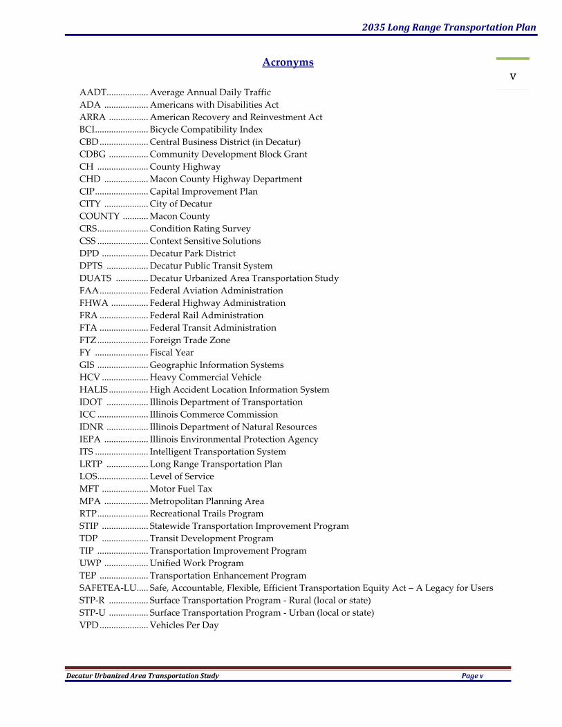
v Acronyms
AADT .................. Average Annual Daily Traffic
ADA ................... Americans with Disabilities Act
ARRA ................. American Recovery and Reinvestment Act
BCI ....................... Bicycle Compatibility Index
CBD ..................... Central Business District (in Decatur)
CDBG ................. Community Development Block Grant
CH ...................... County Highway
CHD ................... Macon County Highway Department
CIP ....................... Capital Improvement Plan
CITY ................... City of Decatur
COUNTY ........... Macon County
CRS ...................... Condition Rating Survey
CSS ...................... Context Sensitive Solutions
DPD .................... Decatur Park District
DPTS .................. Decatur Public Transit System
DUATS .............. Decatur Urbanized Area Transportation Study
FAA ..................... Federal Aviation Administration
FHWA ................ Federal Highway Administration
FRA ..................... Federal Rail Administration
FTA ..................... Federal Transit Administration
FTZ ...................... Foreign Trade Zone
FY ....................... Fiscal Year
GIS ...................... Geographic Information Systems
HCV .................... Heavy Commercial Vehicle
HALIS ................. High Accident Location Information System
IDOT .................. Illinois Department of Transportation
ICC ...................... Illinois Commerce Commission
IDNR .................. Illinois Department of Natural Resources
IEPA ................... Illinois Environmental Protection Agency
ITS ....................... Intelligent Transportation System
LRTP .................. Long Range Transportation Plan
LOS ...................... Level of Service
MFT .................... Motor Fuel Tax
MPA ................... Metropolitan Planning Area
RTP ...................... Recreational Trails Program
STIP .................... Statewide Transportation Improvement Program
TDP .................... Transit Development Program
TIP ...................... Transportation Improvement Program
UWP ................... Unified Work Program
TEP ..................... Transportation Enhancement Program
SAFETEA-LU ..... Safe, Accountable, Flexible, Efficient Transportation Equity Act – A Legacy for Users
STP-R ................. Surface Transportation Program - Rural (local or state)
STP-U ................. Surface Transportation Program - Urban (local or state)
VPD ..................... Vehicles Per Day

2035 Long Range Transportation Plan
Decatur Urbanized Area Transportation Study Page 1
CHAPTER 1. INTRODUCTION
This Update of the 2030 Long Range Transportation Plan (LRTP) was prepared by staff for the Decatur
Urbanized Area Transportation Study (DUATS). DUATS is the Lead Agency for the Decatur
metropolitan area. The LRTP addresses potential transportation improvements to the year 2035 for the
Metropolitan Planning Area (MPA). The purpose of this plan is to identify, plan, and guide future
year transportation decisions and improvements within the MPA.
The LRTP views transportation in terms of the movement of people and goods, not just vehicles.
While the plan analyzes specific transportation modes (e.g. roadways, public transportation,
bicycles/pedestrians, rail, and aviation), it stresses the interrelationships between modes and
encourages the integration of the various transportation components into a system that efficiently and
cost-effectively meets the mobility needs of the area’s citizens, businesses, industries, and the traveling
public. It also must take into account the interdependent aspects of transportation planning with
other community planning activities such as land use, human and natural resources, economic
development etc..
The LRTP is designed to be financially realistic. The recommendations are based on reasonable
expectations and projections of available federal, state and local revenue. The LRTP does not assume
that significant additional funding will be available beyond current funding levels. Furthermore, the
plan is intended to be flexible and capable of responding to new or changing conditions. In a sense,
the plan is a work in progress, and not a finished product. Land use and transportation studies are
continuously being completed which may result in changes to the plan. Moreover, the plan must be
updated at least every five years, and amendments may occur more frequently in response to the
changing realities of an urban transportation system.
Perhaps most importantly, the LRTP reflects the vision and direction of local officials, relevant
agencies, stakeholders, and the general public. The plan development has included public
participation opportunities intended to assure the public was able to be involved in the planning
process. The public provided valuable information needed to develop, maintain, and carry out an
effective transportation plan. The public involvement process provides opportunities to educate the
public about transportation planning, creating an informed community, which leads to better
planning.
Long Range Transportation Planning
Transportation planning is a process for accommodating the linkages between land use, economic
development, mobility, and environmental conditions to improve the quality of life for area citizens.
The planning process is comprehensive, examining the contribution of all transportation modes (e.g.,
roadways, transit, bicycles, pedestrians, rail operations, and aviation). The process is a coordinated
effort between federal, state, local and private transportation providers. The process is also
continuous, anticipating and responding to the changing transportation needs within the community
over the next twenty to twenty-five years.
The transportation planning process recognizes the interdependent relationship that exists between
land use and transportation decisions. Rarely are transportation issues (i.e., congestion,
circulation/accessibility problems, etc.) confined to one jurisdiction or unit of local government.
Instead, the impact of transportation and development decisions often extend beyond defined city and
2035 Long Range Transportation Plan
Decatur Urbanized Area Transportation Study Page 2
village boundaries and can have significant regional impacts. The designation of the MPA and the
process of preparing the LRTP is intended to analyze the transportation system from a regional
perspective and to identify appropriate solutions to address the area’s future transportation demands.
By doing so, individual communities are able to more effectively manage their transportation
resources and meet their future needs.
Regional Planning
Transportation planning should have and is intended to have a major impact on development in the
MPA. This Update intends to bring sustainable development characteristics to the forefront through
the efficient use of resources including balanced land development and conservation and more
compact land uses. Encouraging developments in and adjacent to existing municipalities promotes
greater density which allows for the more efficient use of transportation funds. More dense and
carefully planned residential, industrial, commercial and mixed use districts encourages the use of
public transit and alternative transportation modes.
Somewhat in contrast, the type and location of transportation infrastructure has a powerful effect on
the location and intensity of land use development. Therefore, it is crucial that the transportation plan
be designed to support the land use plan, both in terms of location and intensity of service to be
provided by different modes. Well planned and located transportation facilities combined with
appropriate levels of service are vital to the success of a sensible development initiative, the efficient
use of limited community resources, enhancement of local and regional security, improvement of the
quality of life, providing an accessible and connected community, maintaining and improving the
economy while helping to instill a sense of pride.
Community cooperation in the planning and development of transportation facilities and associated
land use is imperative and is required. Governments and their citizens must cooperate to ensure
efficient connectivity and the wise use of resources. The U.S. Department of Transportation mandates
a comprehensive, cooperative and continuing approach to transportation planning in the MPA prior
to receiving federal transportation dollars. The entity authorized to carry out this Federal mandate is
the Decatur Urbanized Area Transportation Study (DUATS).
DUATS was formed in 1964 to handle the transportation activities in the MPA. The organization and
structure of DUATS was re-authorized in 2002 through the execution of an intergovernmental
agreement. Amendments to that Agreement were adopted in early 2006 in which the Lead Agency
planning functions were moved from Macon County to the City of Decatur. DUATS is made up a
Policy Committee, a Technical Committee, an Advisory Committee and staff. DUATS’ mission, goals
and objectives are guided by the Long Range Transportation Plan (LRTP), which is prepared at least
every five years.
Transportation planning activities are undertaken by DUATS staff in cooperation with the Illinois
Department of Transportation (IDOT), Federal Highway Administration (FHWA), Federal Transit
Administration (FTA) and member entities. The Policy Committee makes final decisions regarding
budget expenditures, project selection and other policy matters affecting the overall operation of
DUATS. The Policy Committee includes the Mayor of Decatur, Macon County Board Chairman, IDOT
Region 4 Engineer, Mayor of Forsyth, and Mayor of Mt. Zion. The Policy Committee is currently
chaired by the Mayor of Decatur. Election of a chairperson and vice-chair happen every other year.
The next elections are slated for June 2010. Any of the voting members, with the exception of the
IDOT Regional Engineer, can be elected to chair the DUATS Policy Committee.
2035 Long Range Transportation Plan
Decatur Urbanized Area Transportation Study Page 3
Under the general direction of the Policy Committee, the Technical Committee manages the overall
transportation planning efforts for DUATS. This committee has the responsibility of professional and
technical review of work programs, policy recommendations and transportation planning activities.
The Technical Committee is comprised of thirteen members representing local governments within
the MPA and IDOT District 7 personnel. The Technical Committee is currently chaired by the County
Engineer. Elections occur every two years. Elections for Chair and Vice-Chair are scheduled for June
2010.
DUATS is the only intergovernmental planning entity in the County. It strongly encourages
cooperation among the jurisdictions and strives for the betterment of the region. Interested parties,
such as the League of Illinois Bicyclists, Decatur Bike Club, Macon County Environmental Resource
Council, Macon County Farm Bureau, business, industry and other stakeholders, also provide input
and help strengthen the cooperative, regional focus.
The long standing regional focus of DUATS took on a significant and historic aspect in 2005 when it
was proposed that DUATS become the sponsoring agency for a countywide comprehensive planning
initiative. One of the many goals of such an endeavor was to formulate a cooperative, mutually
beneficial, unified plan that would not consider land use, housing, economic development, natural
resources or transportation singularly, but would study and then formulate a plan that acknowledged
the interdependence of jurisdictions within the County that would promote regional concepts to help
bring about “one community,” and would provide a more concrete and understandable relationship
between transportation, land use and other community planning activities.
After gaining the approval of FHWA and IDOT, along with the unanimous support of the Decatur
City Council and the Macon County Board the Macon County – Decatur Comprehensive Plan project was
commenced in September 2006. In July 2009, the Draft Plan was placed on public display with the
intent to have the Draft undergo an extensive public review and comment period. This multiple year
planning study was shaped by the people of Macon County. Hundreds of personal contacts and
interviews with local leaders were conducted. Focus groups and working group committees met
numerous times to provide input and guidance on proposed goals and objectives. Town Hall
meetings were held in July and September 2007 with over 500 interested citizens telling us their stories
while educating us about areas and issues of importance to them. Presentations were made to civic
and community groups by the staff. Out of this extensive public participation process came many
recommendations. Those recommendations, along with an extensive factual analysis of our existing
conditions, trends and comparison with other communities, were woven together to form the
foundation for the Comprehensive Plan.
In August 2009, the Macon County – Decatur Comprehensive Plan became an official reality through its
unanimous adoption by the Macon County Board and Decatur City Council. The adopted Plan
recognizes the critical importance of community wide and interdisciplinary planning and the
importance of coordinating land use and development activity with transportation planning. DUATS
intends for the Comprehensive Plan and the LRTP to be complimentary in a time when fiscal and
human resources are limited and transportation infrastructure needs are increasing.
There are two separate geographical boundaries as part of DUATS’ transportation study area. These
boundaries include the following.
Urbanized Area Boundary – Established by the U.S. Bureau of the Census and updated
every 10 years as part of the U.S. Census. Defined areas include a central city and contiguous

2035 Long Range Transportation Plan
Decatur Urbanized Area Transportation Study Page 4
territory that combined has at least 50,000 people and a density of over 1,000 people per
square mile. This area can be expanded by coordination between IDOT and local officials but
must include all of the Census identified Urbanized Area. The Federal Highway
Administration (FHWA) and the Governor must approve it. It is typically updated every
three (3) to not more than five (5) years and may be done in conjunction with the LRTP
update. This boundary is used to determine which projects are eligible for urban or rural
funding. The Urbanized Area Boundary was reviewed and approved in December 2008.
Metropolitan Planning Area (MPA) Boundary –The MPA must include all of the Urbanized
Area and should include all contiguous areas that may become urbanized during the time
frame covered in the 2035 LRTP. This boundary is established by agreement between DUATS
and the Governor through IDOT. A copy of the boundary is provided to FHWA. This
boundary is used to determine which projects are included in the Transportation
Improvement Plan (TIP) and LRTP and therefore are eligible for federal funding. The MPA
Boundary was reviewed and approved in December 2008.
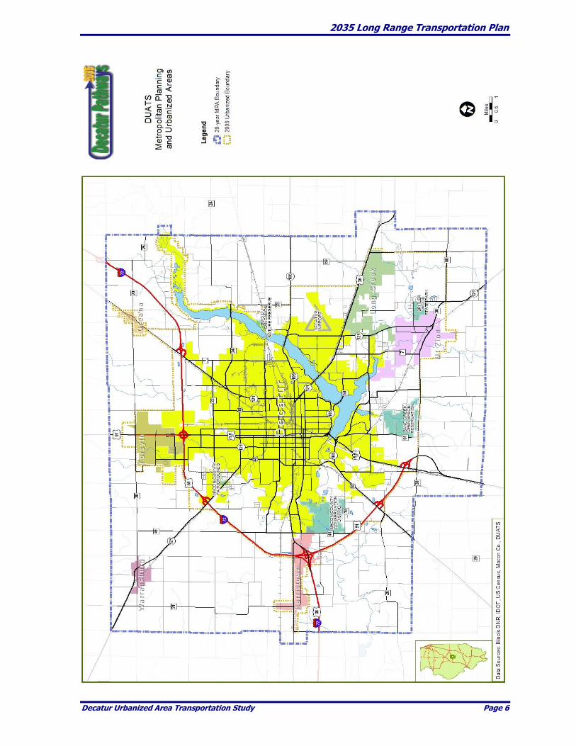
Our Metropolitan Planning Area
The City of Decatur lies at the center of the MPA. There are seven municipalities located within its
boundaries. They include Decatur, Forsyth, Harristown, Long Creek, Oreana, Mount Zion and
Warrensburg.
Macon County is connected to the region and the country by a system of Federal, State and County
highways as shown on Page 6. Interstate 72 wraps around the City of Decatur from the northeast to
the southwest in a sixteen-mile partial loop providing a means of access from the interstate system to
the major. Interstate 72 provides an east-west connection to the U.S. National Interstate Highway
System. U.S. Route 51 is a four-lane limited access facility running north-south from south of
Bloomington, Illinois through Macon County south to near Pana, Illinois. It continues south as a two
lane route to the Ohio River. U.S. Route 36 provides access to and through Decatur from the east and
feeds I-72. Illinois Route 48 is a two lane, state highway with a northeast-southwest orientation.
Illinois Route 121 has a northwest-southeast orientation. Illinois Route 105 runs from its terminus in
southwest Decatur east through the County and completes the spoke pattern that provides highway
access to and from all areas of Macon County.
The minor arterial system combined with the principal arterial system creates a system that is at the
high range of the Federal Highway Administration Guidelines. The collector road system, driven by
the township level grid of rural roadways lies well above the accessibility percentage set by the
FHWA.
The current MPA boundary encompasses approximately 219 square miles. The Urbanized Area
boundary encompasses approximately 103 square miles. Current population estimates for the MPA
are 105,400 and 101,600 for the Urbanized Area. As mentioned above, the MPA contains the City of
Decatur, the villages of Forsyth, Harristown, Long Creek, Mt. Zion, Oreana and Warrensburg. A map
showing the boundaries of the MPA can be found on the following page.
Population projections done during the creation of the Macon County – Decatur Comprehensive Plan
revealed that growth over the next twenty years will be modest. If these projections hold true over the
life of this LRTP, transportation and infrastructure investments will have to be made wisely and with
2035 Long Range Transportation Plan
Decatur Urbanized Area Transportation Study Page 5
prudence.
Since 1990, the MPA overall has experienced an increase in housing while simultaneously losing
population. The increase in housing and loss of population has been unevenly distributed. During the
past fifteen years population and housing units increased in Hickory Point, Oakley, and Mount Zion
Townships. Population decreased, but housing units increased in Harristown, Whitmore, Long Creek
and South Wheatland townships. The Villages of Forsyth and Mt. Zion experienced large percentage
increases in population and housing. The City of Decatur lost population and housing units.
During this same fifteen year period, average home size increased while household size declined.
Development trends have been toward the urban fringes which pulls the housing market and
associated commercial development further from the existing, older core neighborhoods. This trend
leaves certain areas with transportation and infrastructure that is underutilized, while requiring large
investments in the construction and installation of new infrastructure to service new development.
Correspondingly, the average commute time and average daily traffic has increased on certain routes.
2035 Long Range Transportation Plan
Decatur Urbanized Area Transportation Study Page 6
2035 Long Range Transportation Plan
Decatur Urbanized Area Transportation Study Page 7
Governing Legislation
To a great degree, Federal legislation defines the LRTP planning process. The Intermodal Surface
Transportation Efficiency Act (ISTEA) of 1991 recognized the economic and cultural diversity of
metropolitan areas, and the need to provide metropolitan areas with more control over transportation
decisions. ISTEA emphasized the efficient use and preservation of the existing transportation
infrastructure, the inclusion of private citizens and stakeholders in the planning process, the
synergistic relationship between all modes of transportation, and transportation linkage with the
environment.
ISTEA was replaced by the Transportation Equity Act for the 21st Century (TEA-21). TEA-21
reaffirmed much of what ISTEA set out to accomplish, including public involvement, linking land use
to transportation planning, a multi-modal approach in developing transportation solutions, the need
for increased mobility and transportation’s key role in economic growth. TEA-21 added the
requirement that the LRTP be financially constrained, meaning each transportation project and
strategy identified in the plan is backed by clearly specified federal, state, local and/or private funding
sources. It also shifted the evaluation of transportation systems from how well the system is physically
operating to how well the system is meeting the needs of the users. It places the public and
stakeholders at the center of the decision-making process, and views transportation in terms of the
movement of people and goods, not just vehicles.
Superseding TEA-21 was the current authorization bill, SAFETEA-LU, Safe, Accountable, Flexible,
Efficient Transportation Equity Act - A Legacy for Users. SAFETEA-LU again affirmed much of its
predecessor but added the requirement that DUATS become more proactive and assiduous in its
assigned tasks and roles in order to enhance its relevance, expand transportation planning support
services and become more assertive in seeking public input and creating working relationships with
associates and partners in local and regional transportation and transportation related matters. It also
requires DUATS to take into account safety, security, operations and maintenance, environmental
mitigation, increasing intermodal connections, efficient freight movement and human services
transportation in its planning activities.
Finally, ISTEA and TEA-21 and SAFETEA-LU are linked with the Clean Air Act Amendments of 1990
(CAAA). The CAAA recast the planning function to confirm that transportation planning will help
and not hinder the region in meeting federal air quality standards. It encourages reduced auto
emissions, and fewer trips by single-occupant vehicles, and it promotes the use of alternative
transportation (transit and bicycles) as a more viable part of the transportation system. Making the
receipt of federal funding dependent upon a region’s ability to meet air quality standards reinforces
the linkage between transportation planning and federal air quality standards. The MPA currently
meets all air quality standards and is not subject to the regulations defined in the CAAA.
Study Process
The DUATS 2035 LRTP is a continuing, comprehensive, and cooperative plan for the future
transportation system. The LRTP provides a blueprint to build upon an ever-evolving process of goal
setting, deficiency analysis, and solution identification. The future transportation system will evolve
as the area’s priorities and conditions change, demographics shift and new technologies develop.
This LRTP defines a balanced program of capital development and systems operations. It provides a
structure and planning process for examining how all modes of transportation can be integrated and

2035 Long Range Transportation Plan
Decatur Urbanized Area Transportation Study Page 8
work collectively to serve the mobility and economic development needs of the MPA. This LRTP has
been developed through the active participation and efforts of DUATS, FHWA, FTA, IDOT, the City
of Decatur, the Decatur Park District, the Village of Forsyth, the Village of Mt. Zion, and Macon
County government along with other local government, agency, and stakeholder input.
Transportation Work Products
To optimize use of transportation resources, transportation projects and programs must be carefully
planned in advance. FHWA and FTA require DUATS to have a three “C” planning process that
results in a transportation plan consistent with the needs of the area. The three primary products of
this process are the Unified Work Program (UWP), the Transportation Improvement Plan (TIP), and
the LRTP. These documents are described as follows:
Unified Planning Work Program – The annually updated UWP outlines proposed tasks and
estimated costs associated with conducting the area’s transportation planning research plus
the administrative activities necessary for the development of the LRTP and TIP.
Transportation Improvement Plan – The TIP is an annually updated, short-range, four-year
programming document which allocates funding for specific transportation projects and
activities in the area. The TIP must include all projects that will use Federal and State funds
within the MPA, including but not limited to; roadway, transit, bicycle, and pedestrian
modes.
Long Range Transportation Plan – The LRTP is the 25 year planning document that
provides a framework for addressing the area’s transportation needs. This includes an
overview of existing and future needs, with defined strategies to meet those needs. This plan
must be updated every 5 years.
Public Involvement
In compliance with SAFETEA-LU, the Public Involvement Plan (PIP) provisions of the 2030 LRTP
were extensively amended in September 2007. During the review for this 2035 LRTP Update, it was
determined that with current and anticipated staff levels, funding and transportation planning
requirements those amendments included activities that were too aggressive and could not be
maintained. This update intends to proactively encourage the involvement of citizens in the
transportation planning process at a realistic and sustainable level.
Public involvement is critical to a transportation planning and the creation of the this LRTP. DUATS
staff and local officials actively solicit comments from those who know the community best: the
people who live and work here. Public involvement informs and educates the public about
transportation planning which in turn leads to better planning. Public participation gives the public a
sense of ownership of the plan. Regular meetings are held by the member entities, by planning and
engineering professionals, by stakeholders and by other representatives of the community. It is a
process of taking part in the transportation planning and decision-making that affects the community.
In September 2008, a group of interested social service providers and local officials began the process
of exploring the alternatives for the provision of a rural transportation system. In November 2008, this
group was extensively expanded to over 90 individuals representing the major social service
providers, units of local government, transit users, stakeholders and other interested citizens and
2035 Long Range Transportation Plan
Decatur Urbanized Area Transportation Study Page 9
became the Macon County Transit Partnership Group. DUATS intends to use this entity as an ongoing
channel for public involvement in the transportation planning process.
DUATS 2035 LRTP Organization
- Chapter 1 provides background on the LRTP development process and information on
the regional setting and transportation system
- Chapter 2 outlines the vision statement, goals, and objectives for the 2035 LRTP.
- Chapter 3 summarizes the existing transportation conditions and identifies
transportation deficiencies within the MPA.
- Chapter 4 identifies the challenges and opportunities in transportation, land use,
population and employment projections leading up to 2035.
- Chapter 5 addresses issues regarding planning for the safety of the transportation
system.
- Chapter 6 identifies security issues.
- Chapter 7 involves a look at environmental conditions and mitigation strategy.
- Chapter 8 discusses the operation and management of the system.
- Chapter 9 examines efforts and initiative to engage the public in the transportation
planning process.
- Chapter 10 includes efforts to improve human services transportation alternatives.
- Chapter 11 analyzes year 2035 conditions for the respective transportation modes and
identifies issues and potential transportation improvements.
- Chapter 12 contains the financial capacity analysis that documents the region’s ability to
implement the potential transportation improvements.
- Chapter 13 identifies the recommended transportation improvements.

2035 Long Range Transportation Plan
Decatur Urbanized Area Transportation Study Page 10
CHAPTER 2. GOALS AND OBJECTIVES
This chapter defines the vision statement and overall goals, and objectives used in developing the 2035
LRTP. A component of this LRTP is that the recommended improvements reflect the values of the area
citizens, businesses, industries, and the traveling public. The goals and objectives provide guidance in the
planning process and define the means by which specific transportation improvements are evaluated.
Vision Statement
The vision statement is a brief description of a desired future condition that is dependent on specific
transportation policies and decisions. The vision statement defines the general direction of the
transportation system if policies and strategies are implemented to address the goals and objectives. The
vision statement frames the development of the goals and objectives which in turn drive the identification
and implementation of the recommended transportation strategies and improvements. The vision
statement is:
Vision Statement
DUATS will continue to develop a regionally integrated multi-modal
transportation system to meet the values, needs, and goals of the area's citizens,
businesses, industries
and the traveling public.
Goals and Objectives
Goals and objectives carry forth the focus of the community’s vision. Goals and objectives are the result of
providing opportunities for and listening to what the citizens, businesses, industries and institutions and
other stakeholders believe are important. Their collective involvement and the correct translation of their
opinions evolve into guidelines and recommendations that provide the various agencies with what
should be constructed, how operations should function, and how best to maintain our transportation
infrastructure.
The coming decades will provide us with a host of challenges. As congestion increases, drive times
become longer, air quality is compromised and infrastructure costs increase it will take the collective
community to adequately and fairly address the issues. At the same time many opportunities will present
themselves. Our ability to meet the challenges and take advantage of the opportunities will be dependent
upon public input.
Goals are general in nature. They pertain to area-wide or systemic issues and may overlap with other
goals as impacts on the system as a whole must be considered. Decision-makers are the ones that assign
priority to the various goals when making implementation decisions.
Goals developed for this LRTP are represented by a continuing and collaborative effort between units of
local government, the Policy Committee, Technical Committee, stakeholders and the public. They reflect
the collective vision that defines important transportation issues within the MPA. The goals provide the
framework for this LRTP.
Objectives expand upon the goal by identifying types of actions that may alleviate the problem. Generally

2035 Long Range Transportation Plan
Decatur Urbanized Area Transportation Study Page 11
there are several objectives associated with a particular goal. They too may overlap with each other.
SAFETEA-LU Planning Factors
SAFETEA-LU established planning factors that must be addressed. The planning factors are intended to
provide a framework and direction on how the projects identified for inclusion in a LRTP should be
prioritized. The following table shows the planning factors and identifies how the goals address them.
The goals and objectives below are expanded later in the Plan.
Relationship of SAFETEA-LU Planning Factors to the 2035 LRTP Goals
Goals and Objectives
2035 LRTP Goals
1) Support the economic vitality of the metropolitan area, especially by
enabling global competitiveness, productivity, and efficiency.
1
2) Increase the safety and security of the transportation system for
motorized and non-motorized users.
1, 5
3) Increase the accessibility and mobility options available to people
and for freight.
3, 4, 5
4) Protect and enhance the environment, promote energy conservation,
and improve quality of life.
6
5) Enhance the integration and connectivity of the transportation
system, across and between modes, for people and for freight.
1, 4
6) Promote efficient system management and operation. 1, 2
7) Emphasize the preservation of the existing transportation system. 2
SOURCE: SAFETEA-LU and DUATS
2035 Long Range Transportation Plan
Decatur Urbanized Area Transportation Study Page 12
Goal and Objectives – #1
Goal
Objectives
1. Develop coordinated multi-
modal transportation system that
facilitates the safe, secure, and
efficient movement of people and
goods to, from, within, and
through the Metropolitan
Planning Area which fosters the
growth of the local and regional
economy.
a) Continue inter-jurisdictional land use and transportation
planning in the MPA to improve and standardize the
regional transportation system.
b) Sustain coordinating planning practices that enhance our
transportation system’s security and safety to ensure access
in the event of natural or national emergencies.
c) Develop regional policies to encourage through trips on
major streets (expressways and arterials) and discourage
them on local streets.
d) Continue the financially constrained 4-year TIP process and
identify projects that would be developed if additional
resources were available.
e) Plan for intermodal terminals to foster efficient transfer of
people and goods between and among various modes of
transportation.
f) Continue the corridors revitalization efforts of the City,
County, and property owners in identifying visual
enhancements, safety and access management issues.
g) Promote community walk-ability by requiring alternate
modes of transportation be incorporated into all new
construction and major reconstruction projects and by
increasing efforts to create dedicated bike and pedestrian
allowing for the connection of people and places.
h) Launch a freight consolidation study to encourage the joint
use of rail facilities which could result in major increases in
efficiencies, reductions in rail/vehicle conflicts and possible
closure of certain rail crossings.

2035 Long Range Transportation Plan
Decatur Urbanized Area Transportation Study Page 13
Goal and Objectives – #2
Goal
Objectives
2. Improve and maintain the
existing transportation system to
make the most efficient, safest
and most cost-effective use of
existing infrastructure
investments.
a) Support projects that maximize the performance of existing
transportation facilities.
b) Utilize management systems to help develop procedures for
continuing studies, facilitate periodic review, and revise
long-range plans.
c) Work to reduce traffic fatalities to less than 1.0 per 100
million vehicle miles travelled by 2015.
d) Assist Decatur Park District in its efforts to retain, expand
and enhance passenger and air freight services at the
Airport.
e) Improve efficiency of roadway facilities by changing traffic
operations or improving route design to upgrade road
capacity in congested and potentially congested areas.
f) Establish a consistent system of road standards and
classifications between municipalities within the MPA.
g) Utilize life-cycle costing to aid transportation investment
decisions.
h) Minimize transportation expenditures through negotiations
with public and private development groups.
i) Maximize the utilization of existing infrastructure by
encouraging innovative and compact development
strategies and minimize future infrastructure development
needs and construction costs through consistent
coordination of regional land use decisions and by using
transportation management techniques.

2035 Long Range Transportation Plan
Decatur Urbanized Area Transportation Study Page 14
Goal and Objectives – #3
Goal
Objectives
3. Promote and expand utilization of
regional facilities.
a) Continue to explore opportunities for passenger rail
service that links the MPA with Chicago, St. Louis,
and other metropolitan areas.
b) Promote the MPA as a regional freight distribution
center by enhancing existing and constructing new
facilities using public-private development
strategies.
c) Develop a regional hierarchy of roads to concentrate
major vehicular movements on uniformly spaced
thoroughfares.
d) Integrate air transportation with local travel modes.
Promote the use of the Decatur Airport to efficiently
and affordably serve regional and national passenger
and cargo movements.
e) Develop transportation centers and inter-city
terminals to promote inter-modal travel and regional
expansion.

2035 Long Range Transportation Plan
Decatur Urbanized Area Transportation Study Page 15
Goal and Objectives – #4
Goal
Objectives
4. Develop and promote a
countywide Public Transit System
that provides area citizens with a
competitive alternative to the
private automobile.
a) Continue to support the efforts of the Macon County
Transit Partnership Group as it works to provide services
which meet the needs of special and at risk groups in the
planning, design, and implementation of a countywide
public transit system and related transportation facilities.
b) Expand transit service between existing and future
residential areas, employment centers and various
transportation services and facilities.
c) Seek additional funding for public transit endeavors to
better serve existing needs and expand transit service for
2nd and 3rd shift employees and weekend users in the MPA.
d) Search for funding and authorizations that would allow
expansion of the transit system to other villages located in
the MPA.
e) Promote site planning and mutually beneficial land use
development strategies and patterns that encourage the
use of public transit and make public transit more efficient
and easier to use.
f) Expand cost effective transit services to serve regional
activity centers during principle hours of operation.

2035 Long Range Transportation Plan
Decatur Urbanized Area Transportation Study Page 16
Goal and Objectives – #5
Goal
Objectives
5. Promote alternative modes of
transportation and related facilities
including pedestrian walkways
and bicycle paths.
a) Plan, develop, and promote bicycle and pedestrian
facilities as viable and efficient forms of transportation for
recreational use and commuting.
b) Develop a system of safe, efficient and clearly marked, on-
street bike lanes and off-street paths and trails throughout
the MPA which connect residential areas, neighborhoods,
schools, parks, service, shopping, and employment centers.
c) Comply with the Americans with Disabilities Act and State
of Illinois requirements by providing clearly marked and
maintained walkways, sidewalks, crosswalks, ramps, and
curb cuts along streets.
d) Promote non-motorized transportation by providing safe,
walk-able environments that include measures to separate
pedestrian movements from vehicular traffic.
e) Require new developments and major reconstructions to
include the installation of sidewalks and other non-
vehicular links and require that road and street
improvements include replacement or construction of
adequate alternative means for non-vehicular traffic.
2035 Long Range Transportation Plan
Decatur Urbanized Area Transportation Study Page 17
Goal and Objectives – #6
Goal
Objectives
6. Coordinate land use and
transportation improvements to
insure compatibility and
sensitivity with the social,
economic, and ecological
environments.
a) Review at least annually the Macon County-Decatur
Comprehensive Plan to maintain that strong relationship
between land use development and transportation
improvements.
b) Preserve adequate rights-of-way for future transportation
facilities including the South East Beltway corridor through
appropriate land use regulations and other legislative
action(s).
c) Minimize displacement and disruption of existing
residential, employment, and tax base areas.
d) Encourage project implementation that provides for
coordinated management with other existing and planned
transportation improvement and future land use plans.
e) Avoid encouraging the penetration of neighborhoods by
vehicular traffic not destined to the area in order to
preserve the quality-of-life.
f) Adopt transportation standards that are consistent with
USDOT and IDOT design guidelines that incorporate
context sensitive solutions where appropriate.

2035 Long Range Transportation Plan
Decatur Urbanized Area Transportation Study Page 18
CHAPTER 3. EXISTING CONDITIONS
The existing transportation chapter contains a conditions report on the transportation network within the
MPA including an evaluation of the individual transportation modes and the interaction and connectivity
between them. Roadways, transit, bicycle/pedestrian, rail and air transportation are included.
Roadways
The MPA contains a typical grid road and street pattern network that is altered by topography,
conservations areas, Lake Decatur and Interstate (I-) 72. The network is generally deemed in good
condition. The MPA is connected to the surrounding rural areas and the region by a system of Federal,
State and County highways. I-72 provides an east-west connection to the national interstate highway
system. US 51, a four lane, restricted access highway between Bloomington to the north and Pana to the
south. Illinois (IL) 48 travels northeast-southwest through Macon County, providing an alternate route
between I-55 and St. Louis and I-57 and Chicago. IL 121 extends northwest and southeast between I-55
and Lincoln and I-57 and Mattoon. US 36 provides an important link between the City of Decatur east to
the Illinois-Indiana border. IL 105 is another east-west route that extends from the junction of IL 48 in
southwest Decatur, east to the Piatt-Macon County line.
As mentioned, topography, Lake Decatur and I-72 interrupt and are obstacles to the grid system. For
example, there are five bridge crossing locations to facilitate the movement of traffic to areas primarily
east and west of the Sangamon River and Lake Decatur. To the south, southwest, across the Sangamon
River and its tributaries, traffic movement is limited to just a few bridge locations. Several residential
developments throughout the MPA use curvilinear street patterns to limit pass through traffic and
increase the amount of developable land.
Functional Classification
Functional classification is a process by which streets, roads and highways are grouped into “classes”
which describes the service level provided and operation of roadways within the transportation network.
The functional classification system facilitates the safe and efficient movement of people and goods.
The majority of the area’s roadway mileage is within the jurisdiction of the City of Decatur. The State of
Illinois has jurisdiction over the interstate, expressways and most of the major arterials. Many of the
minor arterials and collectors, based on roadway mileage, is under jurisdiction of the Macon County
Highway Department.
One area that lacks a sufficient number of high classification routes is in the east and southeastern portion
of the MPA. This area is generally southeast of Lake Decatur, around Mt. Zion and Long Creek. The
South East Beltway would address this concern by providing a major thoroughfare in the southeast
portion of the MPA. The South East Beltway would have significant mobility benefits in terms of
accessibility and traffic movement in the southeast and east portions of the MPA.
The Urban Classified System provides for the efficient movement of traffic. The system is well connected
and provides for continuous traffic flow resulting in good circulation. Exceptions are found during peak
travel periods on Lake Decatur bridge crossings, on Pershing between Woodford and Monroe Streets and
Route 51, north from Mound Road through Forsyth.

2035 Long Range Transportation Plan
Decatur Urbanized Area Transportation Study Page 19
There are further disruptions to the traffic flow involving freight rail movements through Decatur,
involving all of the area’s rail companies. Other areas of disruption are Brush College Road at Illinois
Route 10 (William Street), Illinois Route 48, south bound, at the junction of Brush College Road and
seasonal traffic delays on Brush College Road as grain trucks deliver product to ADM.
The map on Page 21 shows the various functional classifications of the roadways in the Decatur MPA.
2035 Long Range Transportation Plan
Decatur Urbanized Area Transportation Study Page 20
Table 2 - Street Design Criteria
Principal Arterials (Interstates, Expressways, and Other Principal Arterials)
Service Principal arterials provide a high degree of continuity of travel around the MPA.
Connection Principal arterials typically connect to other principal arterials.
Form Principal arterials normally have at least four lanes with a traffic median or turn lane.
Frequency Spacing of principal arterials should relate to the need to connect major destinations.
Access Properties abutting the principal arterial should not have direct access onto Arterials.
Land Use Land uses adjoining Principal arterials should be protected from the negative effects of
traffic by large setbacks and landscaping techniques including vegetative screens and
berms.
Minor Arterials (Major Streets)
Service Minor arterials provide continuous travel through the MPA.
Connection Minor arterials provide connection to areas of high activity and connect the County
Highway System to the road network.
Form Minor arterials should have be a total of four lanes wide with opposing traffic separated
by a median or two lanes wide with a third lane for turning movements.
Frequency Minor arterials should occur no more often than one every mile intervals within the
MPA.
Access Access to minor arterials from abutting property should be limited to public roads.
Land Use Land uses along minor arterials should be protected from the negative effects of traffic by
large setbacks and landscaping techniques including vegetative screens and berms.
Urban Collector Streets and Roads
Service Collectors link local streets and roads to minor arterials. Urban collectors should not
provide a high degree of continuity for travel or serve as alternatives to minor arterials.
Connection Collectors should collect traffic from local streets and distribute it to the minor arterials.
Form Collectors vary from two to four lanes wide and are usually less than two miles in length.
Frequency Collectors occur throughout the urban area.
Access Abutting properties normally have access onto urban collectors.
Land Use When urban collectors only provide connection between local streets and minor arterials
no special land use considerations are needed.
Local Streets (Minor Residential Streets and Roads)
Service Local streets provide for travel from individual properties to urban collectors.
Connection Local streets connect local traffic to collectors.
Form Local streets typically are no more than two lanes wide in residential areas.
Frequency Local streets occur universally throughout the MPA.
Access Properties are allowed direct access on to the local streets and roads.
Land Use Local streets typically require no special land use considerations.

2035 Long Range Transportation Plan
Decatur Urbanized Area Transportation Study Page 21

2035 Long Range Transportation Plan
Decatur Urbanized Area Transportation Study Page 22
Average Daily Traffic Counts
Average daily traffic (ADT) counts on Federal and State within the MPA were obtained from IDOT in the
summer of 2009. The figures in parentheses represent the 2004 traffic counts. The interstate, freeways and
arterials continue to carry the largest traffic volumes. The roadway segments with the highest 2009 ADT
were at US Route 51 between I-72 and Barnett Street in Forsyth with 29,000 VPD (28,700 VPD) and
Pershing Road at 24,800 VPD just east of Jasper Street (28,400 VPD). Interstate 72 carries between 11,400
VPD east of US Route 51 (11,800 ADT) and 12,400 VPD (15,500 VPD) near Harristown.
The three major bridges crossing Lake Decatur each experienced volume growth between 2000 and 2009.
The largest increase was observed on the William Street Bridge which increased from approximately
4,000 VPD in 2000 to 13,300 VPD in 2009. The US 51 Bridge experienced the second highest growth
increasing from 14,700 VPD in 2000 to approximately 29,400 in 2009. The US Route 36 Bridge decreased
slightly from approximately 24,700 VPD in 2000 to 24,400 VPD in 2009 Selected ADT volumes for the
MPA are displayed on Page 23.
A further analysis of segments at intersections shows the highest ADT counts through intersections occur
at Pershing and Route 51 (Water and Main Streets) with 36,050 vehicles per day, Mound and Route 51
with 34,900, Route 51 and Barnett Avenue at 33,600 and Pershing and Jasper having an ADT 32,200.
Number of Lanes
The majority of roadways within the MPA are two-way roadways. Most of the mileage having an
assigned functional classification are four lane, many with turn lane options. One exception is the Main
Street/Water Street arterial couplet that runs north-south from south of the Decatur Central Business
District (CBD) north to Pershing Road. Many segments along this one-way couplet have three or more
traffic lanes and in places left and/or right turn lanes. The number of lanes within the MPA is shown on
Page 24.

2035 Long Range Transportation Plan
Decatur Urbanized Area Transportation Study Page 23
2035 Long Range Transportation Plan
Decatur Urbanized Area Transportation Study Page 24
2035 Long Range Transportation Plan
Decatur Urbanized Area Transportation Study Page 25
Truck Traffic
There are eight designated state truck routes within the MPA. State truck route classifications are
generally based on truck weight, maximum load allowances, and vehicle size. There are three truck route
classifications designated by IDOT with classifications I and II being present in the MPA. The following
table identifies the designated truck routes within the MPA. The first two are Class I and remainder of the
routes are Class II.
Designated Truck Routes within the MPA
Truck Route From To
I-72 Sangamon County Line Piatt County Line
US 51 I-72 (Exit 133) Business Route 51
US 36 I-72 (Exit 133) Piatt & Moultrie Co. Lines
US 51 Dewitt County Line I-72
BR 51 Through City of Decatur
US BR 51 - US 51 exit (North of Elwin) US 51 exit (South of Elwin)
IL 48 (north segment) to Piatt County Line I-72 (Exit 144)
IL 48 (south segment) Christian County Lin US 51 exit, Taylorville Road
IL 105 Piatt County Line 22nd Street (Decatur)
IL 121 (north segment) Logan County Line I-72 (Exit 138)
IL 121 (south segment) US 36 - Airport Rd. Intersection Moultrie County Line
SOURCE: IDOT Designated State Truck Route System, January 2008, City of Decatur, DUATS.
Class I truck routes are approved for all load widths of 8’6” or less. Typically, Class I truck routes include
interstate facilities as is the case in the MPA. Class II truck routes are approved for all load widths of 8’6”
or less with a wheel base no greater than 55 feet. In general, trucks can typically travel on local roads
within five miles of a designated Class II truck route and within one mile of a Class I truck route.
The primary truck route within the MPA is I-72. This route provides same-day access to more than 60
large markets including Chicago, St. Louis, Detroit, Minneapolis, Kansas City and Cincinnati.
Designated truck routes
Most of the designated truck routes directs truck traffic around the City of Decatur. The exceptions are
US 36 which directs east-west truck travel through the northern boundary of Decatur’s CBD and Business
Route (BR) 51 from Route 51 to Eldorado Street (US Route 36). Both are Class II Truck Routes and carry
significant truck traffic. The same is true for IL 48 between I-72 near Brush College Road and I-72 which
carry substantial truck traffic to industries such as ADM and Caterpillar. U.S. Route 51 and Illinois Route
121 carry a large number of freight trucks through the villages of Forsyth and Mt. Zion respectively.
Through truck traffic in Decatur’s CBD on Business Route 51 is a major concern given the large size of the
vehicles and the negative aesthetic and environmental impacts such as interrupting traffic flow,

2035 Long Range Transportation Plan
Decatur Urbanized Area Transportation Study Page 26
pedestrian safety, excessive fumes, noise, vibration and potentially harmful cargo. These impacts lead to
significantly negative effects on the downtown business climate, pedestrians and shoppers. Travel
disruptions and delays are common.
It is extremely important in analyzing transportation improvements, security, safety, environmental
issues and maintenance that the utilization of roads and streets and the impact of through freight truck
traffic be considered against other transportation modes and routes.
In 2006, the City of Decatur and numerous private investors embarked on a major, aggressive downtown
redevelopment initiative. The initiative included the demolition of unsafe, obsolete buildings, the
construction of a multi-million dollar office and retail complex and creation of park like open space on
Water Street and utility and infrastructure improvements. The upper floors of a number of existing
buildings have been converted into modern residential dwelling units. Retail stores have invested in
façade and other business enhancements. The goal of this initiative is to provide a customer and
pedestrian friendly environment in which to frame Decatur’s CBD as a historic, cultural, governmental
and entertainment center. Through freight truck traffic of BR 51 is a major deterrent to reaching this goal.
In response to the need for a viable alternate truck route, a Phase I route study was begun in 2006. It
examined the general alternatives to moving through truck traffic off of BR 51 which would greatly
reduce the adverse impact of have large commercial carriers hauling loads through the CBD. A follow-up
and more detailed study was begun in 2008 and is on-going at the time of this LRTP. Both studies are
seeking the best alternative for the CBD environment while seeking to avoid increasing the cost of
hauling freight to and from industrial entities located in the east and northeast parts of Decatur, and to
mitigate any potentially adverse impacts on property owners on or near the selected alternative truck
route.
Truck Volumes
Truck volumes, or Heavy Commercial Vehicle (HCV) volumes, were provided by IDOT for the most
recent years (2008 and 2009). Table 3-3 displays the ten highest truck volume locations identified within
the MPA. HCV are divided into two categories, multi-unit vehicles (commonly referred to as semis) and
single-unit vehicles.
Top Ten Truck Route Segments in the MPA
Source: IDOT, DUATS
LOCATION FROM TO SU MU HC = SU + MU ADT
I – 72 U.S. 51 IL 48 550 2300 2850 10900
I – 72 IL 121 US 51 550 2250 2800 10400
IL 48 Brush College I - 71 1350 1300 2650 13500
I -72 US 36 IL 121 450 2050 2500 10800
I – 72 I – 72 / US 51 W. Edge MPA 550 1700 2250 13200
I -72 N. Edge MPA IL 48 450 1800 2250 10000
US 51 I- 72 Barnett Ave. 700 1250 1950 28800
US 51 Barnett Ave. Weaver Road 900 1250 1900 18400
IL 48 & IL 121 Jasper St. Woodford St. 1050 750 1800 23800
IL 48 I – 72 Cundiff Road 450 1300 1750 9400
2035 Long Range Transportation Plan
Decatur Urbanized Area Transportation Study Page 27
I-72 carries the highest truck volumes within the MPA. I-72/US 51, between IL 121 and US 36, had the
highest truck volume at 3,000 per day. This represents nearly 23% of all traffic recorded at this location.
In general, approximately 17% to 23% of all traffic observed on I-72 through the MPA were HCV. Other
roadways within the MPA typically carry 7% to 12% HCV. Pershing Road was the highest non-interstate
facility carrying approximately 2,600 HCV per day. This volume represents approximately 9% of the
daily traffic along this roadway segment.
Capacity Analysis
The planning level capacity analysis used in 2004 to evaluate the existing roadway system was reviewed
in 2009. The analysis compared existing traffic volumes to acceptable capacity levels based on number of
lanes and functional classification. The calculated volume-to-capacity (v/c) ratio was then compared to
the standards shown in the table below to reasonably determine streets and roads that are approaching-
capacity, at-capacity, or over-capacity.
Planning Level of Service Standards
In the 2030 LRTP, 470 miles of streets and roads were analyzed to identify possible areas of traffic
congestion within the MPA. That analysis showed that approximately 21 miles of roadway within the
MPA were approaching-capacity, at-capacity, or over-capacity. Of this 21 mile total, 8.3 miles (39.3%)
were identified as approaching-capacity and may not require immediate attention.
In 2009, DUATS compared similar conditions regarding average daily traffic count, number of lanes,
functional classification, etc.. The factors and conditions were in almost all instances very similar to those
found in 2004. Capacity and congestion segments remained essentially the same. DUATS continues to
monitor roadway segments identified as approaching-capacity. In summary, less than three percent of
the 470 miles of streets or roads are either at-capacity or over-capacity.
In all instances involving congestion and/or capacity, there is little in the way of imminent, economical
solutions. In all instances the segments shown as congested, near or at capacity there is limited right of
way to be utilized for additional lanes. Property improvements and land uses are very close or on the
existing right of ways. Purchasing additional land and paying market price for the property
improvements is financially problematic. Bridge widening cannot be economically justified. Widening the
Lake Decatur crossings to allow additional lanes is financially prohibitive.
The terms “congested” and “near or at capacity” are by definition relative. Observation and experience
define these terms more in terms of inconvenience within the MPA. Such conditions are rarely adverse.
Typically, the terms equate to having to wait for a few multiple signal sequences for vehicles to move
through a particular segment.
Planning Volume-to-Capacity Level of Service Ratio
Approaching-Capacity 0.80 - 0.95
At-Capacity 0.96 - 1.10
Over-Capacity 1.11 or greater
SOURCE: URS Corporation.

2035 Long Range Transportation Plan
Decatur Urbanized Area Transportation Study Page 28

2035 Long Range Transportation Plan
Decatur Urbanized Area Transportation Study Page 29
Safety Analysis
High accident locations were identified for roadway segments and spot locations within the MPA. The
crash data used to identify locations of interest for this LRTP was compiled from local and state agencies,
including IDOT. The accident/crash data is presented for the period 2005 to 2007, which is the most
current information available.
Segment Analysis
Roadway segments and intersection were reviewed in 2009 for obvious changes in frequency, patterns or
other characteristics. The overwhelming majority of crashes happened within 50 feet of intersections. The
figure below shows the intersection crash data between 2005 and 2007. There were a number of segments
used by IDOT which have changed from those used in the 2030 LRTP, which makes direct correlations at
times difficult. As a result of the changes in segment parameters and the fact that most crashes happen
within 50 feet of intersections, DUATS presents the data in relation to intersections instead of by segment.
High accident locations are shown on the map on Page 31.

2035 Long Range Transportation Plan
Decatur Urbanized Area Transportation Study Page 30
Intersection / Spot Location Analysis
Intersection data supplied by IDOT and DUATS for the time period of 2005 through 2007 was analyzed.
The table which follows displays the intersection and spot accident crash locations. The order of the
ranking is not an indication of the relative danger of any particular location. Further analysis must be
done on the following data to determine locations that pose a more significant risk for an accident.
DUATS will then determine intersection and/or roadway segments that warrant some form of
improvement based on the results of a more detailed study.
LOCATION
TOTAL
CRASHES
SERIOUS
INJURIES
FATALITIES
U.S. Route 51 & W. Barnett Ave., in Forsyth 146 3 0
Pershing Road and North MacArthur Road 71 1 0
Pershing Road and North Main Street 62 1 1
Eldorado Street and North 22nd Street 51 1 0
Eldorado Street and North Main Street 51 2 1
U.S. Route 36 and East William Street 50 2 0
Mound Road and North Water Street 47 0 0
Pershing Road and North Water Street 47 1 0
Eldorado Street and North Franklin Street 44 3 0
North Water St and Ash Avenue 41 1 0
East Mound Road at North M. L. King Jr. Dr. 40 4 0
East Pershing Road at North 22nd Street 40 3 0
West Grand Avenue at North Monroe Street 37 3 0
East Garfield Avenue at North Main Street 33 3 0
East Garfield Avenue at North Water Street 31 6 0
North 22nd St at N 27th St 18 0 1
Hubbard Avenue at N. Brush College Road 15 3 0
Hubbard Avenue at North 27th Street 14 1 1
East Eldorado Street at U.S. Route 36 11 0 1
IL Route 48 at South Wyckles Road 9 1 1
West Mound Road at North Taylor Avenue 8 0 1
Hubbard Avenue at North Woodford Street 6 0 1
East Cleveland Avenue at South Main Street 6 1 1
West Grove Road at U.S. Route 51 5 2 1
East Cantrell St at South 17th St 2 0 1
West Main Street at Elder Lane 1 0 1
West Washington Street at Strawn Road * 1 0 1
TOTAL CRASHES, INJURIES, FATALITIES 887 42 13
SOURCE: IDOT and DUATS
2035 Long Range Transportation Plan
Decatur Urbanized Area Transportation Study Page 31

2035 Long Range Transportation Plan
Decatur Urbanized Area Transportation Study Page 32
Access Management
Access management is an important concept that can help maintain acceptable levels of mobility and
minimize exposure to potential crashes. DUATS needs to study the whole issue of access management on
an MPA basis. Until recently, little or no attention was paid to access issues. Development along major
streets and roads was allowed with no known access management standards. DUATS needs to adopt
standards regarding curb cuts, drive entrances, etc., within the MPA. Recommendations and
encouragement should be provided to local jurisdictions to control and limit access to major streets and
roads. In reviewing reconstruction and major renovation of streets and roads, DUATS should strongly
encourage local entities to study existing access and work to reduce the number of curb cuts.
DUATS reviewed the congested roadway segments and made comparisons to the locations having high
accident rates. Four areas need a detailed study of the benefits of access management. Such a study
would prove useful for planning roadway and corridor improvements. Access management standards
and controls would increase safety by reducing traffic accidents and pedestrian injuries, permit the more
efficient flow of traffic and provide much enhanced aesthetics. It should be noted that congestion as
expressed in this LRTP are relative to the region, limited generally to twice daily and on a seasonal basis.
The first of the four areas in the MPA that should be scheduled for access management studies would be
US Route 51 from the Hickory Point Mall area in Forsyth south to Pershing Road in Decatur. The area
north of I-72 was rated as over-capacity and also contained the highest spot accident location within the
MPA at Barnett Avenue (146 accidents in 2005 through 2007).
The US Route 51 corridor, south of I-72 to Pershing, is also at-capacity and includes a few spot and
segment accident locations. This area will reviewed to determine if existing access points could be
improved/eliminated to increase mobility and improve traffic safety. One area which has contributed to
an slightly increase in the traffic volume on and near the intersection of US Route 51 and Mound Road
was the development of a commercial center which contains a Target, Olive Garden and other businesses.
The land on which these businesses now site was the former site of a public middle school.
The second location identified was Pershing Road between Oakland Avenue and 22nd Street. This east-
west corridor includes several segments ranging from approaching-capacity to over-capacity. The
corridor also includes several spot accident locations including in particular the intersections of Water
and Main Streets at US Route 51. The segment between approximately Monroe Street and Jasper Street
was identified as a high accident location. Generally, along its entire route, Pershing Road has a very
large number of access points. Many businesses have multiple access points in relatively close proximity
to other access points. This causes safety issues and confusion for drivers and pedestrians alike. DUATS
believes that access management techniques would be beneficial to traffic operations along this corridor.
The third area involves Eldorado Street (US 36) from Business Route 51 east to 22nd Street, that portion of
IL Route 121 from 22nd Street to Lake Decatur and a portion of 22nd Street north of US 36 to
approximately E. Condit Street. Roadways in this area carry a large volume of traffic, large truck
volumes, have multiple railroad crossings and numerous signalized, spoke style intersections with a very
large number of access points. The area overall is at-capacity or over-capacity.
The area also includes several high accident spot locations. US 36 is also identified as a high segment
accident location for much of the corridor including the Lake Decatur bridge crossing. 22nd Street also

2035 Long Range Transportation Plan
Decatur Urbanized Area Transportation Study Page 33
has a high accident locations south of US 36.
The fourth location which deserves a detailed traffic flow and access management study is the Route 48,
Boyd Road, I-72, Brush College Road area. Prior to 2007, development in the area included a car
dealership on Boyd Road and a motel off of Brush College Road. In 2007, a Pilot Truck Stop was
constructed at the northeast corner of Route 48 and Boyd Road. This resulted in a huge increase in traffic
leaving and entering Route 48 from Boyd Road. Much of the increase is truck traffic. All of this occurs in
close proximity to the eastbound off and on ramps of I-71. Additionally, vehicular traffic many times is
backed up to the Boyd Road intersection from the traffic signal at Route 48 and Brush College Road. This
results in congestion on Route 48 southbound and safety issues for vehicles northbound as they near the
Boyd Road intersection.
The map on Page 34 identifies the four areas within the MPA that should undergo a detailed review to
determine how access management could benefit traffic operations.
2035 Long Range Transportation Plan
Decatur Urbanized Area Transportation Study Page 34

2035 Long Range Transportation Plan
Decatur Urbanized Area Transportation Study Page 35
Pavement Condition
IDOT collects pavement condition data on Federal and State routes every two years. The data is reported
in the Condition Rating Survey (CRS). The last pavement condition survey was conducted in 2007 and
2008. As part of the continuing transportation planning process, this information is placed in the GIS
database and reviewed as it becomes available. For the purpose of the LRTP, the IDOT pavement ratings
have been condensed into the following categories:
Excellent
Fair
Poor
Critical
Roadways classified as excellent can be described as being adequately maintained, recently built or
reconstructed. They have a sound existing sub-base, base and surface. Fair roadways are described as
having older surfaces that have been well maintained and are generally smooth, free of potholes, and
devoid of high and low areas. Roadways classified as poor are those that should be scheduled for at least
a surface overlay or other minor reconstruction. These roadways may remain in this condition for many
years before deteriorating to a state of critical condition. Critical roadways are those where the pavement
has deteriorated to the point that major reconstruction is probably warranted.
Within the MPA there were a total of approximately 158 miles of rated pavement. Of this total, nearly 96
miles (60.5%) were rated as excellent. Another 60 miles (38.1%) was rated as fair. Only 2 miles (1.4%) of
roadways within the MPA were rated as poor while no miles of roads were rated in critical condition.
The map on the following page displays the 2008 and 2009 pavement condition ratings within the MPA.

2035 Long Range Transportation Plan
Decatur Urbanized Area Transportation Study Page 36

2035 Long Range Transportation Plan
Decatur Urbanized Area Transportation Study Page 37
Structural Condition
There are 249 numbered bridges or drainage structures within the MPA. These structures range in age
from early steel truss bridges dating to about 1900 to modern reinforced concrete box culverts and
bridges. The lengths range from the twenty-foot minimum that the State of Illinois uses to define bridges
up to more than two thousand feet.
IDOT maintains 59 structures in the MPA, many of which were built in the late 1970’s in conjunction with
the I-72 and Route 51 Bypass project. Macon County maintains 17 bridges within the MPA while various
townships within the MPA maintain another 18 bridges. The City of Decatur has maintenance
responsibility over 16 bridges. Within the MPA there are also numerous railroad bridges that are
maintained by the private rail companies.
The majority of bridges within the MPA meet the minimum standard vertical clearances. One exception
is the City of Decatur maintained bridge located at Garfield over 22nd Street (058-6001). Several railroad
overpasses within the MPA do not meet the minimum vertical clearance standards. These include
overpasses at:
N. Main at N&W RR W. Main St. at RR (Oakland)
E. Condit St. at RR N. Monroe at N&W RR
W. Forrest St. at RR E. Prairie at IC RR
N. Jasper St. at RR N. Van Dyke at RR
Becker-E. Lake Shore Dr. at RR (US 36)
Structural condition ratings are based on criteria provided in the Illinois Structure Information System
(ISIS) manual. For the purpose of the LRTP, the ten general IDOT condition ratings were condensed into
the following five rating categories.
Excellent
Good
Fair
Poor
Critical

2035 Long Range Transportation Plan
Decatur Urbanized Area Transportation Study Page 38

2035 Long Range Transportation Plan
Decatur Urbanized Area Transportation Study Page 39
Transit Operations
Transit service within the DUATS MPA is operated by the City of Decatur, Decatur Public Transit System
(DPTS). Since September 2001, two in-depth transit studies focusing on the DPTS fixed-route service and
paratransit service have been completed. As a result of these studies many changes, including a
realignment of the fixed-route system, have been implemented. The following describes the existing
transit operations within the DUATS MPA.
System Overview
The DPTS sub-contracts to First Transit which employs approximately 70 employees who operate the
transit system. Of this total, there are approximately 45 part-time/full-time bus drivers, 5 to 6 van drivers,
and additional personnel including mechanics and staff. The DPTS operates fifteen fixed bus routes, and
accompanying paratransit service, serving primarily the City of Decatur with limited service to portions
of the Villages of Forsyth, Harristown, and Long Creek. The DPTS also operates one trolley route which
serves downtown Decatur. The photograph below shows the fixed-route service vehicles.
DPTS Fixed-Route Service Vehicles
The DPTS fixed-route service operates on a pulse system: all of the buses arrive at the Transit Center at
the same time, to allow passengers to transfer between bus routes. With only a few exceptions, all of the
bus routes “pulse” at :15 and :45 minutes past each hour throughout the service day. The Transit System
operates Monday through Friday from 5:30 a.m. to 7:15 p.m. and Saturday from 6:30 a.m. to 7:15 p.m.
There is no service currently provided on Sunday and on major holidays.
The DPTS also provides paratransit services to individuals with disabilities who
are unable to access the fixed-route system. This paratransit service uses six wheelchair accessible vans
operated by the DPTS and a subsidized taxicab program. Paratransit service is available during the same
hours and days of operation as the fixed-route system, but operates on a demand-responsive basis.
Facilities
In 2002, the DPTS opened the Senator Severns Transit Center located at the corner of Jackson and William
Street. This 5,000 square foot multi-modal facility serves as the primary transfer point for passengers
using the DPTS. The Transit Center includes a number of amenities such as an indoor waiting area,

2035 Long Range Transportation Plan
Decatur Urbanized Area Transportation Study Page 40
restrooms, and vending area. The Transit Center also includes a full-time, on-site DPTS employee who
can provide route and schedule information. Transit users are also able to purchase transit tokens, passes
and punch cards on-site. The Transit Center is intended to be used as a multi-modal facility, as a drop-off
and pick-up point for a variety of privately operated services including:
Taxi cabs,
Inter-city bus lines, such as Greyhound; and
Shuttle services which transport passengers to Amtrak stations and airports all over central
Illinois.
The DPTS Administrative Office Building and Maintenance Garage is located at 555 East Wood Street in
Decatur. The facility was constructed in 1996. The bus storage building at 100 Industry Court, located
directly behind the Administrative Office Building, was constructed in 1980. The following photographs
show the DPTS Transit Center and Administrative Office Building .
DPTS Senator Severns Transit Center
DPTS Administrative Office Building
Transit Services
The DPTS operates fixed-route transit routes, including one trolley route, and complementary
paratransit service for people with disabilities. The following sections describe these services.

2035 Long Range Transportation Plan
Decatur Urbanized Area Transportation Study Page 41
Fixed-Route Service
Fixed-route service is limited to the City of Decatur with one exception: Route 51, Water St - Hickory
Point Mall. This route serves the Hickory Point Mall in the Village of Forsyth. Major destinations and
service areas are identified in Table 3-9 for the respective transit routes. The fixed-route service is
displayed in Figure 3-16.
Table 3-9. DPTS Fixed-Route Major Destinations / Service Areas
Route
No. Route Service Areas
______________________________________________________________________________
11 Martin Luther King Drive - Martin Luther King Jr. Dr -- north of Eldorado /
Meadowlark K-Mart / Cub Foods / Driver's License Facility /
Wellington Way and Portage Place Apartment
Complexes / Decatur Correctional Center /
Meadowlark Subdivision
______________________________________________________________________________
12 Airport - Wal-Mart East Thomas Jefferson School/ Baum School / East
Eldorado Street / St. Patrick's Elementary School/
Illinois Power (main office)/Wal-Mart Plaza East/
Decatur Airport
______________________________________________________________________________
21 Monroe - Wal-Mart North Decatur Memorial Hospital/Spring Creek Plaza
Aldi’s / Social Security Office / Wal-Mart Plaza
North / Shadow Lane / Bristol Gardens
______________________________________________________________________________
21c Monroe - Wal-Mart North Decatur Memorial Hospital/N. Oakland Ave./
via McKinley & N. Taylor Aldi’s / Social Security Office / W. Mound Rd. /
Wal-Mart Plaza North / Shadow Lane / Bristol
Gardens
______________________________________________________________________________
22 St. Mary's Circulator E. Eldorado Street / A. E. Staley's / Pine's
Shopping Center / Osco's at 16th and Cantrell /
Eisenhower High School / St Mary's Hospital
______________________________________________________________________________
31 W. Grand - Ravina Park Van Dyke St. / Brintlinger's / Ravina Park
Subdivision / MacArthur High School
______________________________________________________________________________
2035 Long Range Transportation Plan
Decatur Urbanized Area Transportation Study Page 42
______________________________________________________________________________
32 South Shores Martin Luther King Jr. Dr. south of Eldorado /
South Water Treatment Plant / South Shores
Shopping Center/Imboden Creek Nursing Home
South Shores School / Holy Family School
______________________________________________________________________________
41 E. Grand - Richland Insight Cable Office / DMH Occupational /
Community College ADM Corporate Office / Richland Community
College
______________________________________________________________________________
51 Jasper - Park 101 Longview Housing / Municipal Services Center
K-Mart / Cub Foods / Driver's License Facility /
Park 101 / Caterpillar Inc.
______________________________________________________________________________
52 West Main - Wyckles Road Millikin University / West End / W. Main St. /
MacArthur High School / Fairview Plaza /
Decatur Conference Center and Hotel
______________________________________________________________________________
53 Enterprise – Taylor Rd Illinois Power Plaza / South Shores Shopping
Center / WAND - TV / Enterprise School /
Decatur Township Office
______________________________________________________________________________
61 Water - Hickory Point Mall Insight Cable Office / CHIC Clinic / Brettwood
Village Shopping Center/Wal-Mart North /
Hickory Point Mall / Gold's Gym
______________________________________________________________________________
62 Oakland Millikin University / The Woods Apartments /
MacArthur High School / Fairview Plaza
______________________________________________________________________________
63 Decatur W. Decatur St. / The DISC / Millikin University
MacArthur High School / Fairview Plaza
______________________________________________________________________________
71 Lost Bridge – Eisenhower High School / St. Mary's Hospital /
Wal-Mart East Airport Plaza (Kroger's) / Wal-Mart Plaza East
______________________________________________________________________________ SOURCE: Decatur Public Transit System, August, 2009

2035 Long Range Transportation Plan
Decatur Urbanized Area Transportation Study Page 43

2035 Long Range Transportation Plan
Decatur Urbanized Area Transportation Study Page 44
DPTS Fixed-Route Major Destination / Service Areas
Trolley Service
The DPTS operates one trolley route that serves downtown Decatur. The Downtown Trolley opened
around the 2000 holiday season and transports approximately 3,000 riders per month. One trolley
operates along the route which starts at the Transit Center on the hour, at 15 minutes past, at 30 minutes
past, and at 45 minutes past the hour. The Downtown Trolley service begins at 7:00 a.m. on weekdays
and at 8:00 a.m. on Saturdays. The last trip of the day starts at 6:00 p.m. The Downtown Trolley provides
service to all major downtown parking lots and garages, and passes close by every downtown location.
There is no charge to ride the Downtown Trolley.
Operation Uplift
All DPTS fixed-route buses are wheelchair accessible. However, the DPTS also provides Operation
Uplift: complementary paratransit services for individuals with disabilities who are unable to use the
fixed-route bus system because of their disabilities. This paratransit service uses wheelchair accessible
Route
Number Route Service Areas
11 Martin Luther King Drive -
Meadowlark
Martin Luther King Jr. Dr -- north of Eldorado / K's Merchandise / Office Depot / K-Mart
North / Cub Foods / Driver's License Facility / Wellington Way and Portage Place
Apartment Complexes / Decatur Correctional Center / Meadowlark Subdivision
12 Airport - Wal-Mart East Thomas Jefferson School/ Baum School / East Eldorado Street / K-mart Plaza East / St.
Patrick's Elementary School / Illinois Power (main office) / Wal-Mart Plaza East /
Decatur Municipal airport
21 Monroe - Wal-Mart North Decatur Memorial Hospital / Spring Creek Plaza / Social Security Office / Wal-Mart Plaza
North / Circuit City Plaza
22 St. Mary's Circulator E. Eldorado Street / A. E. Staley's / Pine's Shopping Center / Osco's at 16th and Cantrell /
Eisenhower High School / St Mary's Hospital
31 W. Grand - Ravina Park - W. Pershing Osco's at Monroe and Pershing / Social Security Office / French Quarter West / Aldi's /
Brintlinger's / Ravina Park Subdivision / MacArthur High School
32 South Shores Martin Luther King Jr. Dr. south of Eldorado / South Water Treatment Plant / South Shores
Shopping Center / Imboden Creek Nursing Home / South Shores School / Holy Family
School
41 E. Grand - Richland Community
College
Insight Cable Office / DMH Occupational / ADM Corporate Office / Richland Community
College
51 Jasper - Park 101 Longview Housing / Municipal Services Center / K-Mart North / Cub Foods / Driver's
License Facility / Park 101 / Caterpillar Inc.
52 West Main - Wyckles Road Millikin University / Holiday Inn
53 Enterprise Illinois Power Plaza / WAND - TV / Enterprise School
61 Water - Hickory Point Mall Insight Cable Office / CHIC Clinic / K's Merchandise / Brettwood Village Shopping Center /
Wal-Mart Plaza North / Hickory Point Mall / Gold's Gym
62 Oakland Millikin University / The Woods Apartments / Mac Arthur High School / Fairview Park Plaza
71 Lost Bridge Wal-Mart East Eisenhower High School / St. Mary's Hospital / Airport Plaza (Kroger's) / K-Mart Plaza East
/ Wal-Mart Plaza East
SOURCE: Decatur Public Transit System, March 2004.C:\My Documents\Jim Work\[tables.xls]transit areas served

2035 Long Range Transportation Plan
Decatur Urbanized Area Transportation Study Page 45
vans operated by the DPTS as well as subsidized taxicabs, under a formal agreement with one or more
local taxicab companies. The rider may choose to use either the DPTS vans or the subsidized taxis. The
rules and regulations of Operation Uplift apply equally to both.
Paratransit service is available during the same hours and days of operation as the fixed-route system,
but operates on a demand-responsive, door-to-door basis. The geographic service area for Operation
Uplift is all of the City of Decatur plus areas outside of the City that are within ¾ of a mile of a DPTS bus
route. Individuals using Operation Uplift pay a one-way fare of $1.50. Personal care attendants or escorts
may accompany an eligible rider. Personal care attendants may ride free of charge while escorts are
required to pay $1.50 per one-way trip.
Individuals must apply for eligibility for Operation Uplift and submit proof of their disability. The
following are categories of people who are eligible for Operation Uplift:
Persons who are unable to board, ride, or disembark from a bus, even if the bus is
wheelchair/handicapped accessible;
Persons who cannot use buses without lifts or other accommodations. These persons are eligible
for Operation Uplift only if accessible fixed route buses are not available on the route on which
they need to travel; and,
Persons with specific impairments or related conditions who cannot travel to a boarding location,
or from a disembarking location to their final destination.
In general, persons with disabilities who are presently riding fixed-route buses are not eligible for
Operation Uplift.
Fare Structure
The current DPTS fixed-route adult bus fare is 75 cents. In 2002, the DPTS implemented a 15 cent fare
increase from the previous adult fare of 60 cents. Youths, ages 5 through 18 and those with an approved
high school card, ride for a reduced fare of 60 cents. Individuals with disabilities are eligible to ride the
fixed-route bus system for a reduced fare of 35 cents. Individuals 65 years of age or older, individuals
with disabilities who are eligible for the State’s Circuit Breaker program, and children less than 5 years of
age ride for free. Free transfers are issued for connections with other DPTS routes. Table 3-10
summarizes the current DPTS fare structure for the fixed-route buses and for Operation Uplift.

2035 Long Range Transportation Plan
Decatur Urbanized Area Transportation Study Page 46
DPTS Fare Structure
TYPE of CASH PUNCH MONTHLY SATURDAY
FARE FARE TOKENS CARDS1 PASSES2 PASSES3
_____________________________________________________________________________________
BUS FARES:
Adult 75 cents 75 cents $13.80 $27.60 $1.50
Youth (age 5 – 18 and 60 cents 60 cents $11.05 $22.10 $1.50
those with approved
high school card)
Child (under 5 with a FREE N/A N/A N/A N/A
fare paying passenger)
Disabled (with Medicare 35 cents 35 cents $6.45 $12.85 $1.50
card or DPTS ID card)
Senior Citizen (65+ FREE N/A N/A N/A N/A
with ID card)
Disabled, Circuit Breaker FREE N/A N/A N/A N/A
(with Circuit Breaker card)
Transfer (restrictions apply) FREE N/A N/A N/A N/A
OPERATION UPLIFT FARES:
Certified Disabled Rider $1.50 N/A $27.60 $55.00 N/A
Escorts (if space is $1.50 N/A N/A N/A N/A
available)
PCA (Personal Care FREE N/A N/A N/A N/A
Attendant)
_____________________________________________________________________________________
SOURCE: Decatur Public Transit System, August, 2009
1 20 rides. 2 Unlimited rides, good only in the month of issue. 3 Unlimited rides, good only for one Saturday.
2035 Long Range Transportation Plan
Decatur Urbanized Area Transportation Study Page 47
Operational Characteristics
The current annual operating budget for the DPTS is approximately $5.7 million.1 A comprehensive
review of the fixed-route system was completed in September, 2001 and a study of the paratransit system
was completed in September, 2003. This section summarizes some of the general findings regarding
transit service within the DUATS MPA.
Ridership
In 2002 based on recommendations contained in the Planning Study, the DPTS implemented a
comprehensive realignment of the fixed-route bus system. These changes went into effect soon after the
DPTS received 13 new buses, and at the same time that the Senator Severns Transit Center was opened.
Ridership had been decreasing for several years leading up to 2002. Starting in 2002 and the many
improvements implemented then, ridership has grown significantly and continuously. Ridership in 2008
was 49% higher than bus ridership in 2001. The following table shows the number of bus riders by year,
and the change and percentage change from the previous year, for calendar years 2001 through 2008.
DPTS Bus Ridership by Year – 2001 through 2008 Route Percent
Year Passenger Count Change Percent
Change
2001 843,325 ---- ----
2002 847,515 4,190 0.50%
2003 911,209 63,694 7.52%
2004 983,368 72,159 7.92%
2005 1,039,354 55,986 5.69%
2006 1,121,789 82,435 7.93%
2007 1,173,301 51,512 4.59%
2008 1,257,931 84,630 7.21%
Total 414,606 49.16%
The paratransit services of Operation Uplift, as previously described, include trips provided by DPTS
vans and by subsidized taxicabs. Ridership for calendar years 2001 through 2008 is provided in table on
the following page. The figures are broken down by vans and by taxicabs. Ridership on Operation Uplift
was not affected by the changes implemented in the fixed-route bus system in 2002. The large changes in
ridership are the result of major changes in the operations of the private taxicab companies, and the
quality of service they have provided.
1 City of Decatur, Illinois, Annual Budget, 2009-2010

2035 Long Range Transportation Plan
Decatur Urbanized Area Transportation Study Page 48
In 2001 the DPTS vans carried 9,516 riders, compared to 44,975 riding in private taxicabs under Operation
Uplift. By 2008 the number of van riders had grown by 115.01% to a total for the year of 20,464 riders.
But during the same time, taxicab ridership dropped significantly, showing a 69.01% decrease. The DPTS
staff have concluded that the large shifts show the riders’ dissatisfaction with the quality of service
provided by the various taxicab operators who have come and gone. The only taxicab company in
Decatur at this time began operating in 2007. Four other companies have started and/or ceased
operations since 2001.
Operation Uplift Ridership by Year – 2001 through 2008
Year DPTS Vans Taxicabs Total Change Percent
Change
2001 9,516 44,975 54,491 ---- ----
2002 8,743 45,162 53,905 -586 -1.08%
2003 12,372 40,881 53,253 -652 -1.21%
2004 14,290 34,989 49,279 -3,974 -7.46%
2005 17,416 22,146 39,562 -9,717 -19.72%
2006 19,445 15,427 34,872 -4,690 -11.85%
2007 21,095 12,956 34,051 -821 -2.35%
2008 20,464 13,939 34,403 352 1.03%
Total -20,088 -36.86%
Vehicle Fleet
The DPTS currently has 32 buses and trolleys for fixed-route service and six vans for paratransit service.
With the exception of the two DPTS trolleys, all transit system revenue vehicles were purchased using
nearly 100% state and federal grant funds.
Under Federal Transit Administration (FTA) regulations, the 12 RTS buses placed in service in January,
1994, were eligible for replacement in 2006. The actual replacement year depends on the availability of
funds and the amount of lead time the manufacturer needs to build and deliver the vehicles. In August,
2009, the DPTS took delivery of 5 new buses, and also placed an order for 4 additional buses, to be
delivered around August, 2010. When these nine buses are in service, all of the 1993 RTS buses will be
disposed of. At that time the DPTS will have 24 buses and trolleys available.
The DPTS fleet of wheelchair lift equipped vans was acquired over a period of years- 1999, 2003 and 2008.
The last two vans were purchased as replacements for two vans purchased in 1993. FTA regulations
allow the replacement of vans after only five years. So the1993 vans were eligible for replacement in 1998
and the 1999 vans were eligible for replacement in 2004. Again, the actual replacement year depends
chiefly on the availability of funds. The DPTS has already applied for a grant for the purchase of two
vans to replace the 1999 vans. Those vans are expected to be delivered around April, 2010. The following
table displays the current vehicle inventory for the DPTS.
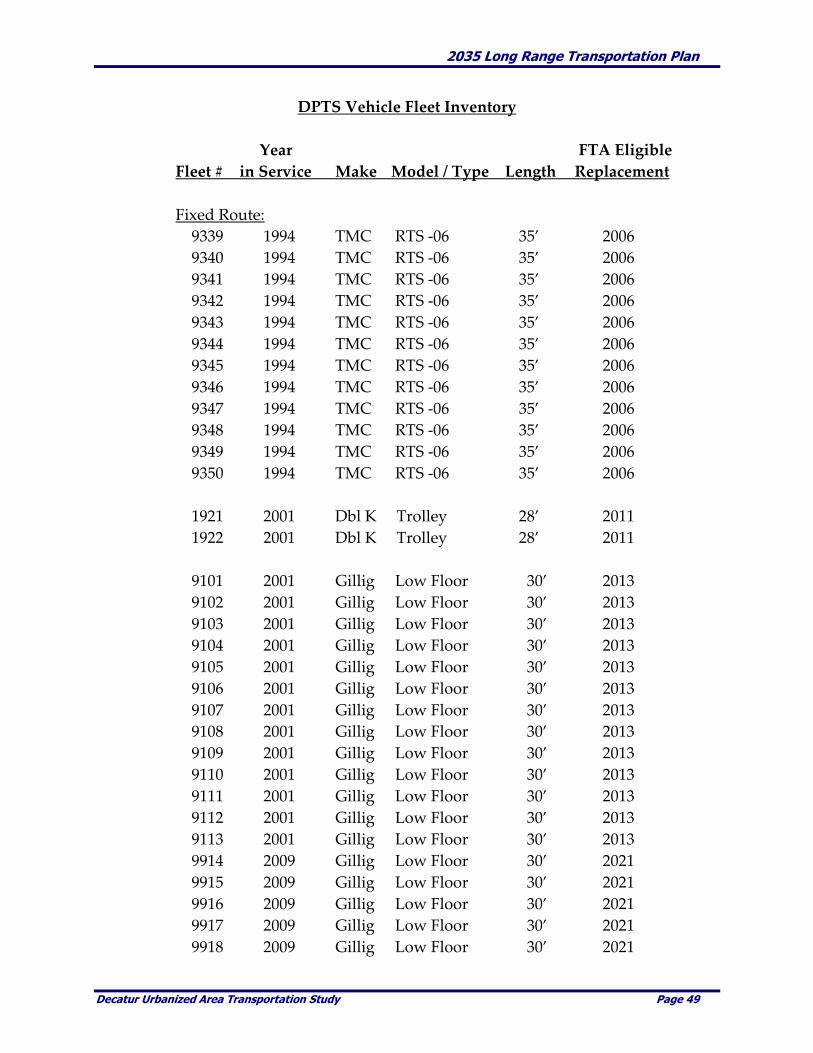
2035 Long Range Transportation Plan
Decatur Urbanized Area Transportation Study Page 49
DPTS Vehicle Fleet Inventory
Year FTA Eligible
Fleet # in Service Make Model / Type Length Replacement
Fixed Route:
9339 1994 TMC RTS -06 35’ 2006
9340 1994 TMC RTS -06 35’ 2006
9341 1994 TMC RTS -06 35’ 2006
9342 1994 TMC RTS -06 35’ 2006
9343 1994 TMC RTS -06 35’ 2006
9344 1994 TMC RTS -06 35’ 2006
9345 1994 TMC RTS -06 35’ 2006
9346 1994 TMC RTS -06 35’ 2006
9347 1994 TMC RTS -06 35’ 2006
9348 1994 TMC RTS -06 35’ 2006
9349 1994 TMC RTS -06 35’ 2006
9350 1994 TMC RTS -06 35’ 2006
1921 2001 Dbl K Trolley 28’ 2011
1922 2001 Dbl K Trolley 28’ 2011
9101 2001 Gillig Low Floor 30’ 2013
9102 2001 Gillig Low Floor 30’ 2013
9103 2001 Gillig Low Floor 30’ 2013
9104 2001 Gillig Low Floor 30’ 2013
9105 2001 Gillig Low Floor 30’ 2013
9106 2001 Gillig Low Floor 30’ 2013
9107 2001 Gillig Low Floor 30’ 2013
9108 2001 Gillig Low Floor 30’ 2013
9109 2001 Gillig Low Floor 30’ 2013
9110 2001 Gillig Low Floor 30’ 2013
9111 2001 Gillig Low Floor 30’ 2013
9112 2001 Gillig Low Floor 30’ 2013
9113 2001 Gillig Low Floor 30’ 2013
9914 2009 Gillig Low Floor 30’ 2021
9915 2009 Gillig Low Floor 30’ 2021
9916 2009 Gillig Low Floor 30’ 2021
9917 2009 Gillig Low Floor 30’ 2021
9918 2009 Gillig Low Floor 30’ 2021
2035 Long Range Transportation Plan
Decatur Urbanized Area Transportation Study Page 50
Paratransit:
1004 1999 Nat’l Mobility Equalizer 18’ 2004
1005 1999 Nat’l Mobility Equalizer 18’ 2004
1009 2003 ElDorado Nat’l Aerolite 18’ 2008
1010 2003 ElDorado Nat’l Aerolite 18’ 2008
1013 2008 ElDorado Nat’l Aerolite 18’ 2013
1014 2008 ElDorado Nat’l Aerolite 18’ 2013
Transit Service Coverage
The DPTS is run by the City of Decatur and operates within the City limits with the exception of limited
service to Forsyth, Harristown, and Long Creek. For the purpose of the LRTP, transit service is evaluated
from the perspective of the entire MPA. The following sections analyze the existing public transit
coverage in proximity to households/residences and non-residential destinations.
Proximity to Households/Residences
Transit coverage in proximity to households/residences was evaluated using Geographic Information
System (GIS) applications to compare the existing transit coverage to the approximate number of
households/residences served. A ¾ mile buffer (to represent the approximate walking distance to a
transit stop) on each side of the transit routes was applied to identify the existing service area coverage.
In the year 2000 there were an estimated 46,283 households within the in MPA. Using an average
household size of 2.345 results in an approximate population of 108,534 for the MPA. Of this total,
approximately 37,013 (80.0%) households, or approximately 86,800 persons, fell within DPTS fixed-route
service area. The map on Page 53 displays the transit service coverage in proximity to
households/residences within the MPA.
Proximity to Non-Residential Destinations
Transit coverage in proximity to non-residential destinations (i.e., major or large employers, shopping
areas, etc.) was evaluated using GIS applications to determine the approximate number of employees
served by transit. A ¾ mile buffer (to represent the approximate walking distance to a transit stop) on
each side of the transit routes was applied to identify existing service area coverage.
Existing DPTS service currently covers the majority of non-residential destinations within the MPA.
Specifically, the Hickory Point Mall, the Decatur Airport, ADM and other major employers, currently
have access via the DPTS fixed-route service. Of the estimated 57,664 jobs within the MPA for the year
2000, nearly 76% (43,825 jobs) were located within the DPTS service area. The map on Page 54 display the
transit service coverage in proximity to non-residential destinations within the MPA.
he following table summarizes the existing DPTS service area coverage.

2035 Long Range Transportation Plan
Decatur Urbanized Area Transportation Study Page 51
Table 3-14. Existing DPTS Service Area Coverage
MPA Estimated Year 2000 Population 1 <<<<<<<108,534
Population with ¾ Mile Buffer of Fixed Routes <<<.. 86,795
Percent of Total Population within ¾ Mile Buffer <..< 80.0%
_________________________________________________________
MPA Estimated Year 2000 Employment . <..<<<<<.57,664
Employment with ¾ Mile Buffer of Fixed Routes <<.. 43,825
Percent of Total Employment within ¾ Mile Buffer <.. 76.0%
_________________________________________________________
Source: URS Corporation, 2030 LRTP, December, 2004, U.S. Census
1 Assumes average household size of 2.345 used in the travel forecasting model and is
consistent with the 2000 U.S. Census.
Areas of Concern
In October 2003, DPTS transit drivers provided specific concerns related to the DPTS. These concerns
included specific railroad crossings that result in travel delays and areas where capacity/geometric
improvements could be implemented to enhance transit operations. The following table summarizes
their specific areas of concern.
Transit Areas of Concern
Railroad Crossings Capacity / Geometric Concerns
Martin Luther King Dr. (MLK) at:
- Wood Street
- Cerro Gordo Street
- Peoria Avenue
Oakland Ave. at Cerro Gordo St.
E. Eldorado Street at:
- 800 Block R.R. tracks
- 22nd Street
Prairie at 22nd Street
Monroe Street at Garfield Avenue
Faries Parkway at:
- 27th Street
- near Brush College Road
Jasper Street at Garfield Avenue
Water Street/Main Street at Johnson
Street
Van Buren at Water and MLK
Church Street from McKinley to Kenwood
Riverside from 16th Street to Maffit
Maffit from Riverside to Cantrell
Medial Drive in South Shores
Ridge Drive and Ridgedale Drive
Division St. between Samuel and 27th
Dennis Street between Grand Ave. and
Ravina Park Road
Dennis Street between W. Main Street and
Riverview Avenue
Walnut between Jasper Street and
Woodford Street
Hayworth Street between Decatur and
Sunset Avenue
Prairie Street from East to 22nd St.
William Street from the Pines to 105
Oakland Avenue from Eldorado to Grand
Avenue
Fulton from C.C. Road to Baltimore
SOURCE: Decatur Public Transit System

2035 Long Range Transportation Plan
Decatur Urbanized Area Transportation Study Page 52
THIS PAGE WAS INTENTIONALLY LEFT BLANK

2035 Long Range Transportation Plan
Decatur Urbanized Area Transportation Study Page 53

2035 Long Range Transportation Plan
Decatur Urbanized Area Transportation Study Page 54
2035 Long Range Transportation Plan
Decatur Urbanized Area Transportation Study Page 55
Bicycle Facilities
Bicycle facilities and trail systems are an increasingly important transportation mode for recreational and
other trip purposes. They are also valuable community assets which greatly enhance the quality of life.
They provide enhanced living environments, have been show to increase property values and
corresponding tax revenues and help stabilize neighborhoods. These facilities provide connections between
places and people. As added benefits, they provide open space, can reduce the amount and intensity of
storm water runoff, provide a “filter effect” which reduces pollution and allow wildlife habitat to remain or
be enhanced.
DUATS is in the process of updating the Decatur Metro Area Greenway Plan, which was created in 1998.
Research and study that has been done on the Greenway Plan s existing and planned bicycle facilities were
evaluated within the MPA. The following section summarizes the findings.
Current System Overview
The number of designated bicycle miles in the MPA has increased three fold since 2004, from the
approximate nine miles to about eighteen miles currently. Of the current total, approximately 8.50 miles are
in Decatur, 3 miles in Mt. Zion and about 7 miles are in Forsyth. The remaining bicycle trips within the
MPA are generally made on existing streets and area roads.
The map on the following page shows the existing bicycle facilities in the MPA.

2035 Long Range Transportation Plan
Decatur Urbanized Area Transportation Study Page 56
Existing Bicycle Network
2035 Long Range Transportation Plan
Decatur Urbanized Area Transportation Study Page 57
Multi-use Trails/Paths
Well-planned and designed multi-use trails/paths can provide good pedestrian and bicycle mobility. The
trails/paths can serve both commuter and recreational cyclists. Generally, the following points are essential
to development of successful, multi-use trails. Trail planning in the MPA should address as many of the
these factors as possible when making trail development decisions.
They should be separate from vehicular traffic lanes with as few street or driveway crossings as
possible to keep the conflict points to a minimum;
To the greatest degree possible, paths should be located along a river, stream or other greenway
in order to offer an aesthetic experience that attracts cyclists and pedestrians;
They should make connections to areas such as shopping malls, downtown, schools, parks,
employment centers and other community destinations;
Well-designed street crossings, with measures such as bike and pedestrian activated signals,
median refuges and warning signs for both motor vehicles and path users should be incorporated;
Trip segments should be shorter than those provided by the road network and should make
connections between dead-end streets or cul-de-sacs, or by providing short-cuts through open
spaces;
Proximity to housing and businesses increases visibility, accessibility and safety. Despite fears of
some property owners, paths have not attracted crime into adjacent neighborhoods;
Good design should include adequate width, sight distance, proper drainage and the avoidance of
blind corners, steep slopes and other obstructions and impediments; and
They must be properly maintained, which includes regular sweeping, brush control and repairs.
A primary bicycle facility is located between Fairview Park and Rock Springs Conservation Area in
Decatur. This trail crosses Stevens Creek to Kiwanis Park and Sunset Avenue ending at the Environmental
Center. In 2008, a connecting trail between Downtown Decatur and Millikin University was completed as
part of the West Main Streetscape improvement project. An additional trail in Decatur was constructed on
the north bank of the Sangamon River near Lincoln Park Drive, between the Lake Decatur Dam and Illinois
Route 48.
As this LRTP was being written, the Decatur Park District had opened bids for Phase 1, covering over 4
miles, of the long planned Stevens Creek Bike Trail. For a variety of reasons the bids were all rejected.
Phase 2 of the Trail are entering the engineering stage.
A new trail in Mt. Zion runs along the eastern part of Harryland Road south and east to near the entrance
to Spitler Woods State Park. A few portions of this trail run alongside, but separately from the streets, with
the remainder being a greenway.
Forsyth continues to incorporate trail facilities as part of most new developments. The Village has an
extensive trail system which ties together residential, commercial and public locations such as the library
and parks.
On-street Facilities
The majority of bicycle travel within the MPA takes place on the Area’s streets and roads. Bicycle travel
can be safely accommodated on streets or roads by planning and designating bicycle routes and providing
on-street facilities such as striped bicycle lanes.
Two streets, Country Club Road from Airport Road to US 36 and Lost Bridge Road, in Decatur have a
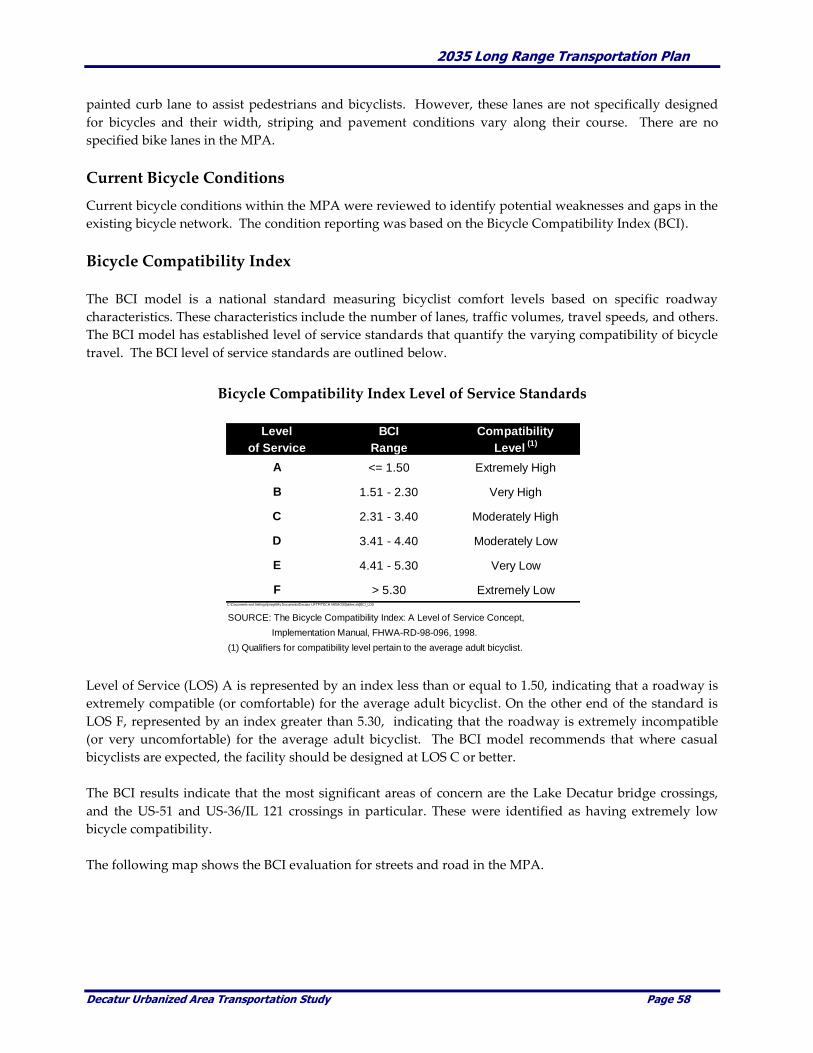
2035 Long Range Transportation Plan
Decatur Urbanized Area Transportation Study Page 58
painted curb lane to assist pedestrians and bicyclists. However, these lanes are not specifically designed
for bicycles and their width, striping and pavement conditions vary along their course. There are no
specified bike lanes in the MPA.
Current Bicycle Conditions
Current bicycle conditions within the MPA were reviewed to identify potential weaknesses and gaps in the
existing bicycle network. The condition reporting was based on the Bicycle Compatibility Index (BCI).
Bicycle Compatibility Index
The BCI model is a national standard measuring bicyclist comfort levels based on specific roadway
characteristics. These characteristics include the number of lanes, traffic volumes, travel speeds, and others.
The BCI model has established level of service standards that quantify the varying compatibility of bicycle
travel. The BCI level of service standards are outlined below.
Bicycle Compatibility Index Level of Service Standards
Level of Service (LOS) A is represented by an index less than or equal to 1.50, indicating that a roadway is
extremely compatible (or comfortable) for the average adult bicyclist. On the other end of the standard is
LOS F, represented by an index greater than 5.30, indicating that the roadway is extremely incompatible
(or very uncomfortable) for the average adult bicyclist. The BCI model recommends that where casual
bicyclists are expected, the facility should be designed at LOS C or better.
The BCI results indicate that the most significant areas of concern are the Lake Decatur bridge crossings,
and the US-51 and US-36/IL 121 crossings in particular. These were identified as having extremely low
bicycle compatibility.
The following map shows the BCI evaluation for streets and road in the MPA.
Level BCI Compatibility
of Service Range Level (1)
A <= 1.50 Extremely High
B 1.51 - 2.30 Very High
C 2.31 - 3.40 Moderately High
D 3.41 - 4.40 Moderately Low
E 4.41 - 5.30 Very Low
F > 5.30 Extremely LowC:\Documents and Settings\jmeye\My Documents\Decatur LRTP\TECH MEMOS\[tables.xls]BCI_LOS
SOURCE: The Bicycle Compatibility Index: A Level of Service Concept,
Implementation Manual, FHWA-RD-98-096, 1998.
(1) Qualifiers for compatibility level pertain to the average adult bicyclist.

2035 Long Range Transportation Plan
Decatur Urbanized Area Transportation Study Page 59
2035 Long Range Transportation Plan
Decatur Urbanized Area Transportation Study Page 60
Spot Locations Deficiencies
In addition to the BCI, members of the Decatur Bicycle Club were contacted and meetings were held to get
their input on identifying spot location deficiencies, locations that present concerns to cyclists and for their
assistance in providing first had information regarding this mode of transportation. The specifics of those
meetings regarding bicycle travel within the MPA are summarized below.
Comments from Decatur Bicycle Club
Members of the Decatur Bicycle Club (DBC) generally felt that there needs to be more done to provide for the safety
and convenience of bicycle riders, to encourage more bicycle riding, and to educate the community with regard to the
rules and laws associated with bicycle riding. They noted that many motorists think that it is illegal for bicyclers to be
on the streets (‘Go ride on the sidewalks where you belong!’) and often display aggressive, dangerous behavior
towards riders.
The DBC encourages the implementation of The Decatur Urbanized Area Comprehensive Bicycle Plan, 1996-2016
which is a supplement to the 1994-2014 Long Range Transportation Plan. This plan still seems very relevant. They
also encouraged implementation of the DBC recommendations communicated to your office in a letter from Jim
Johnson dated January 7, 2004. They advised that Mr. Johnson’s recommendations remain relevant for this LRTP
update.
Included here are a few of the suggestions generated by discussion among some of the DBC members at a meeting on
August 13, 2009.
1. Develop E W/ N S bike routes through the city. Maybe Wood St and Mound Rd for east-west. Maybe
Monroe St and Jasper St for north-south.
2. Purchase abandoned railroad lines for future trails now.
3. All new or improved road/street projects make bicycle and pedestrian compatibility a priority.
4. Bike lanes marked and kept clean for riding with bicycles.
5. Bike lanes evenly paved without grate openings parallel to direction of travel.
6. Bridges should be crossable without riding in car traffic.
7. Signage for bicycle traffic.
8. Bike racks around the city and on buses.
9. Bike storage lockers downtown.
10. Trail maps, benches, and water fountains for riders convenience.
11. Roads and streets kept in good repair with even pavement.
It was also suggested that it would be a good idea to have an alternate transportation advocate in the planning office to
represent alternate transportation, to write grants, etc. This person should be actively involved both in the planning
and in the implementation of ideas beneficial to people in the community who wish to utilize alternate transportation.
One of the most frequently mentioned concerns of bicyclists is the strong desire to provide safe and
adequate crossings of Lake Decatur. The lack of adequate sidewalks or other facilities that would afford a
safe means of crossing Lake Decatur is also supported by the BCI model and technical analysis The
following pictures show the existing condition of the US Route 51 and US Route 36 crossings over Lake
Decatur. High travel speeds, high traffic volumes, narrow shoulders and lack of adequate sidewalks make
crossing Lake Decatur by any means other than motorized vehicle extremely difficult and very dangerous.

2035 Long Range Transportation Plan
Decatur Urbanized Area Transportation Study Page 61
Accessibility to Community Resources
Accessibility to community resources such as schools, universities, libraries, and parks, commercial areas
and employment centers are important aspects of any bicycle network. These community resources were
overlaid with the existing MPA bicycle system to determine areas that may lack bicycle accessibility.
Potential bicycle improvements will be identified to maximize bicycle connections to community resources.
The map on the following page identifies the existing bicycle system in relationship to various community
destinations and facilities.
Intermodal Connections
Intermodal connections currently require bicyclists to share roadways with automobiles, trucks, and buses
in all but a very few locations. Safety and accessibility for cyclists and pedestrians is important. Future
planning should strongly emphasize and require provisions for alternative modes of transportation in
conjunction with new roadways or reconstruction whenever possible. Providing alternative modes of
transportation needs to be a primary concern when making street and roadway improvements. Street and
roadway design and construction should always provide accommodations for bikes and pedestrians.
Another consideration must be bicycle parking. For bicycles to be considered a viable travel option, it is
necessary for major destinations to accommodate bicycle parking. One example of this is the bicycle
parking provided at the Senator Severns Transit Center located at the corner of Jackson and William Street.
Bicyclists are able to ride to the Transit Center, park their bicycle, and ride the DPTS buses. On a more
negative note, there are no provisions for bicycle parking anywhere near the Decatur Civic Center. Since
the Civic Center houses the majority of City offices, it should provide accommodations for the cycling
public.
DPTS is considering the installation of bike racks on buses to further accommodate this intermodal
transportation option.

2035 Long Range Transportation Plan
Decatur Urbanized Area Transportation Study Page 62
2035 Long Range Transportation Plan
Decatur Urbanized Area Transportation Study Page 63
LIST OF MAJOR TRIP ATTRACTIONS SHOWN ON THE PREVIOUS PAGE
1. Richland Community College
2. Millikin University
3. MacArthur High School
4. Eisenhower High School
5. St. Teresa High School
6. Decatur Christian School
7. Hillside Bethel Christian School
8. Thomas Jefferson Middle School
9. Johns Hill Magnet School
10. Stephen Decatur Middle School
11. Stevenson Elementary School
12. Washington Elementary School
13. Dennis Elementary School
14. Michael E. Baum Elementary School
15. Parsons Accelerated School
16. Enterprise Elementary School
17. South Shores Elementary School
18. Lutheran School Association
19. Our Lady Lourdes
20. Holy Family Elementary School
21. St. Patrick Elementary School
22. Northwest Christian Campus
23. St. James Elementary School
24. Forsyth Elementary School
25. Mt. Zion Intermedaite School
26. Macon County Fairgrounds
27. Decatur Airport
28. Decatur Public Library
29. Forsyth Public Library
30. Mt. Zion Public Library
31. St. Mary’s Hospital
32. Decatur Memorial Hospital
33. Hickory Point Mall
34. Caterpillar
35. ADM
36. Tate & Lyle
37. PPG
38. Pershing Pre-K Center
39. Franklin Elementary School
40. Harris Elementary School
41. Hope Academy
42. Durfee Magnet School
43. Oak Grove Elementary School
44. Robertson Charter School
45. Decatur Area Technical Academy
46. French Academy
47. Brush College Elementary School
48. Southeast Elementary School
49. Muffley Elementary School
50. Garfield Montessori School
51. Target Center
52. McCaughey Primary School
53. Mt. Zion Grade School
54. Mt. Zion High School
55. Oreana Elementary School
56. Warrensburg-Latham Sr/Jr High School
57. Warrensburg Elementary School

2035 Long Range Transportation Plan
Decatur Urbanized Area Transportation Study Page 64
Rail Operations
Rail is an extremely important element in the local transportation system. Several rail operations provide
service to major employers in the area including ADM, Tate and Lyle and Caterpillar. The following
section describes rail operations within the MPA.
System Overview
Seven rail lines currently form a radial spoke pattern as they pass through the MPA. Four railroads
currently serve the Decatur area: Canadian National, Norfolk Southern Railway, CSX Transportation, and
the short line Decatur Junction Railway Company. Decatur Junction operates between Assumption and
Cisco while providing service to grain elevators.
Major employers such as ADM, Tate and Lyle and Caterpillar are primary rail users. ADM operates a
railcar rebuilding facilities and owns a fleet of railroad cars comparable to that of the largest railroads in
North America.
Norfolk Southern handles approximately 2,000 freight cars daily in and out of Decatur and carries over 70
million tons of goods annually. Major products being shipped include grain and food products, alcohol
from corn and soybeans, and construction equipment. The following map show the existing rail operations
in the MPA.
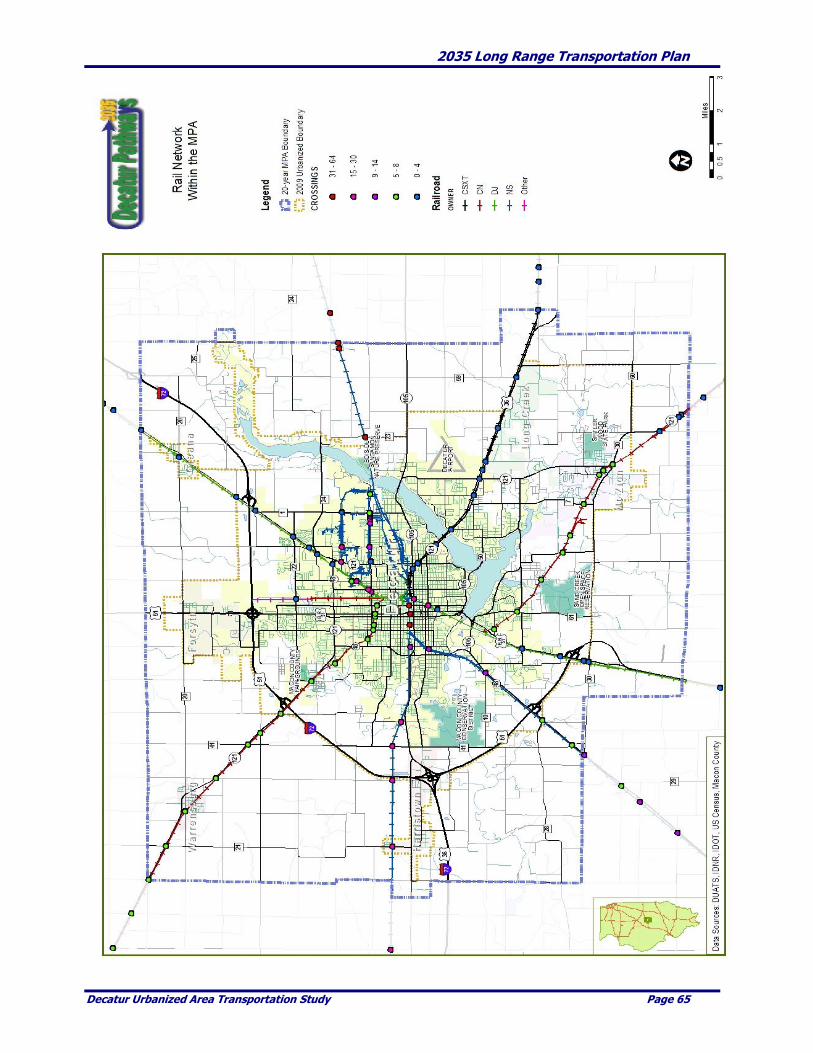
2035 Long Range Transportation Plan
Decatur Urbanized Area Transportation Study Page 65

2035 Long Range Transportation Plan
Decatur Urbanized Area Transportation Study Page 66
At-grade Rail Crossings
In Macon County there is a total of 136 at-grade rail crossings. Of this total, 85 (61.0%) at-grade rail
crossings are located within the MPA. A further breakdown of the 85 crossings within the MPA shows that
over 80% are located in Decatur. This is important in that at-grade rail crossings can be a significant source
of traffic delays depending on the number, length and speed of trains that operate per day along a
particular corridor. Within the MPA the number of delays and extended overall travel delay associated
with these crossings occurs regularly due to the large number of trains, the length of the trains, the
relatively slow speed of trains in the urban environment and the high traffic volumes on the streets and
roads.
Accident History and Prediction
Accident history and accident prediction at at-grade highway-rail crossings was reviewed for the MPA.
Accident prediction is based on the findings from the Accident Prediction Report for Public At-Grade
Highway-Rail Crossings as provided by the Federal Railroad Administration (FRA) Office of Safety
Analysis Highway-Rail Crossing Safety & Trespass Prevention.
Accident prediction reports were originally developed as a tool to alert law enforcement and local officials
of the important need to improve safety at public highway-rail intersections within their jurisdictions.
However, the accident prediction tool can also be used to identify particular crossings that may require
physical safety improvements or enhancements.
The accident prediction formula is based upon two independent factors (variables) which include (1) basic
data about a crossing's physical and operating characteristics and (2) five years of accident history data at
the crossing. For the purpose of this analysis, the most recent five-year accident data was available from
2004 to 2008. At the date of this LRTP there was one reported accident in 2009.
The table on the following page identifies the number of train crossings per day. The map on Page 67
shows the location of the at grade rail crossings.

2035 Long Range Transportation Plan
Decatur Urbanized Area Transportation Study Page 67
Highest Number of Train Crossing per Day
Crossing Number of
Rank ID RR City Crossing Trains per Day
1 479186S NS Decatur M L King Jr Drive 64
1 479188F NS Decatur Water Street 64
1 479191N NS Decatur Edwards Street 64
4 479171C NS Decatur Angle Crossing Road 51
4 479173R NS Decatur Oakley Road 51
4 479174X NS Decatur Shelby Road 51
4 479176L NS Decatur Sangamon Road 51
8 291377C CN Decatur 27th Street 30
9 291236T CN Decatur Eldorado Street 20
9 291239N CN Decatur William Street 20
9 291241P CN Decatur M L King Jr Drive 20
9 291376V CN Decatur 22nd Street 20
9 291388P CN Decatur Woodford Street 20
9 291389W CN Decatur Jasper Street 20
9 291390R CN Decatur Garfield Avenue 20
9 328518T NS Decatur Fairies Parkway 20
9 328519A NS Decatur Fairies Parkway 20
9 328520U NS Decatur Fairies Parkway 20
9 328521B NS Decatur Fairies Parkway 20
9 479256E NS Decatur Sunnyside Road 20
9 479257L NS Decatur Wyckles Road 20
9 479258T NS Decatur Glascow Road 20
9 479260U NS Decatur Meridan Street 20
9 479262H NS Decatur Meridian Road 20
9 479263P NS Decatur Illinois Ct. 20
9 479265D NS Decatur ML King Jr. Drive 20
9 479269F NS Decatur Acom Road 20
SOURCE: Federal Rail Administration and DUATS.
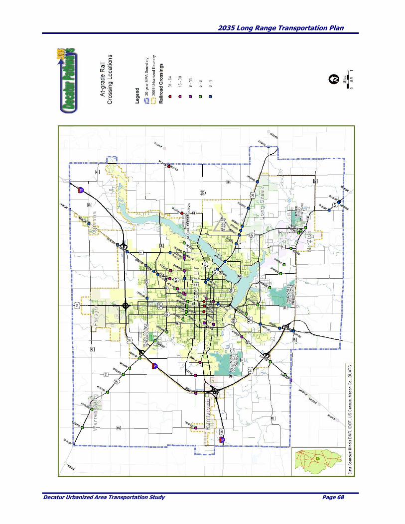
2035 Long Range Transportation Plan
Decatur Urbanized Area Transportation Study Page 68

2035 Long Range Transportation Plan
Decatur Urbanized Area Transportation Study Page 69
It is important to understand that the accident prediction does not directly imply that particular crossings
are the more dangerous than others. Rather, the data provides an indication that conditions are such that
one crossing may possibly be more hazardous than another based on the specific data that is in the
program. The accident prediction methodology is only one of the tools that might be used to determine
where and how to focus attention for improving safety at public highway-rail intersections.
The following table summarizes the accident history at at-grade crossing locations in the MPA by year
(2004 – 2008). As of the date of this LRTP there was one reported accident in 2009 at crossing ID 328512C,
Norfolk Southern at Fairies Parkway.
CROSSING ID RR STREET 2004 2005 2006 2007 2008 TOTAL
328512C NS Fairies Parkway 1 1 2
499206B NS Wyckles Road 1 1
291378J CN Brush College Road 4 4
291377C CN 27th Street 1 1
291373A CN Hubbard Avenue 1 1
292858Y CN MLK Jr. Drive 1 1
328516E NS Brush College Road 1 1 2
328522H NS Fairies Parkway 1 1
291241P DJ Wood Street 1 1
291384M CN Harrison Street 1 1
292856K CN Water Street 1 1
292850U CN Monroe Street 1 1
328520U NS Fairies Parkway 1 1
TOTAL 1 4 3 4 6 18
Source: Federal Rail Administration & DUATS
Intermodal Connections
The MPA is well located in terms of having the ability and infrastructure in place to ship products to other
parts of the country. With the exception of west coast destinations, such as Los Angeles and Seattle, most
goods can be shipped to their destination within two days by either rail or truck. The table that follows
displays the approximate travel time (in days) for rail and trucks.
Although existing surface transportation affords the ability to ship products quickly and with general ease,
intermodal access is somewhat limited within the MPA. Currently, there is no rail access to the airport and
there are limited rail spurs serving major industries such as ADM and Caterpillar. The track to the old
Firestone plant is still in place serving some locations for steel unloading for a fabrication plant and for
scrap dealers. One local business entity, G & D Integrated, recently completed a $5 million expansion. The
expansion includes additional facilities for its container and logistics supply chain distribution network.
Their network utilizes trucks, rail and ocean going containers which combined move over 10 million tons
of freight per day. Much of this tonnage goes through the Decatur facility.
One possible location for an intermodal facility is located off the CSX track near the Business industrial
park located south of the Decatur Airport. However, current rail traffic volumes would likely not warrant
the development of an intermodal facility at this time. Further study and discussion is strongly encourage
as to the location and future construction of an intermodal freight facility.

2035 Long Range Transportation Plan
Decatur Urbanized Area Transportation Study Page 70
Distance and Travel Time
Recent Improvements
Maintenance of rail infrastructure is principally the responsibility of the railroads. However, local
jurisdictions, especially municipalities take an active role in working with rail operators on projects that
will enhance the efficient movement of freight through the region.
Recent rail improvements within the MPA have focused on improving specific at-grade crossing locations.
The most recent improvements include the improved crossing at E. Wood and MLK and on Route 36.
These were completed in 2008 and 2009. No specific grade separated facilities have been identified for
construction at this time.
Days by Days by City Miles Rail Truck
Atlanta 592 2 1
Chicago 179 1 1
Cincinnati 270 1 1
Cleveland 473 1 1
Dallas 764 3 2
Denver 901 2 2
Detroit 422 1 1
Indianapolis 165 1 1
Kansas City 344 1 1
Los Angeles 1,935 4 4
Memphis 380 2 1
Minneapolis 500 3 1
New Orleans 758 2 2
New York 906 2 2
St. Louis 120 1 1
Springfield 36 1 1
Seattle 2,075 4 4
SOURCE: DUATS.

2035 Long Range Transportation Plan
Decatur Urbanized Area Transportation Study Page 71
Aviation
The following provides an overview of existing facilities and operations at the Decatur Airport. The
airport is located approximately four miles east of downtown Decatur at 910 Airport Road. It is one of
eleven primary airports in the State of Illinois.
System Overview
The Decatur Airport is owned and operated by the Decatur Park District. The Airport is one of only five
park district-operated airports in the state of Illinois and the only park district-owned airport served by an
air carrier (American Connection). The Airport encompasses an area of approximately 2,200 acres and
includes over 5,000,000 square feet of pavement surfaces for aircraft operations (runways, taxiways and
parking aprons) and 360,000 square feet of roads and vehicle parking areas. The Decatur Airport has the
fourth-longest runway in the state at 8500’ with two other runways measuring 6800’ and 5300’ in length.
The Decatur Airport is located along the east-central edge of the MPA. The airport maintains three
runways. The primary runway, 6/24, at 8,500 by 150 feet, can accommodate large jet service. The surface
of 6/24 is grooved asphalt and concrete. Runway 12/30 is 6,800 feet by 150 feet with a surface of grooved
(partial) asphalt and concrete.
Runway 18/36 is 5,300 by 150 feet with a surface of grooved asphalt. All are served by a full taxiway
system and monitored by a control tower. Two multiple storage hangers are on site to house some of the
125 base aircraft. One is 27,000 square feet and the other is 8,000 square feet. There are 115 T-hangers also
on site.
The terminal includes two gates, baggage-handling conveyors, ticketing counters, automobile rental
offices, and a restaurant with a capacity of 130 persons. Full snow removal capabilities are present and a
fire station is located on the field allowing 24/7 operations.
A commuter airline provides service between Decatur and St. Louis. The Illinois Army National Guard
maintains helicopters, as well as some fixed wing aircraft on site.
Facilities The Decatur Airport Terminal Building is a 24,000 square foot ground level facility housing airline and car
rental counters, seating areas for passengers and guests, baggage claim area, administrative offices and a
restaurant/banquet facility. Close-in parking is available for visitors and travelers have the convenience of
long-term parking at no-charge. The airport amenities/businesses include the following:
American Connection Ticket Counter
Avis Rent-A-Car
“Main Hangar” Restaurant and Banquet Facility
Lobby Seating Area
Volunteer Information Desk
Baggage Claim Area
Advertising Displays
Motel Courtesy Phone
Business Center
Airport Administrative Offices
Foreign Trade Zone and U.S. Customs
2035 Long Range Transportation Plan
Decatur Urbanized Area Transportation Study Page 72
Foreign Trade Zone #245 Foreign Trade Zone (FTZ) #245 was established at the Decatur Airport in 2000 with Decatur Park District
being named as the “Zone Grantee”. FTZs are designated sites where special customs procedures apply.
The designated area is called a General Purpose U.S. FTZ, which for Custom purposes is considered
outside the United States. This designation allows nearly any imported merchandise to be brought into a
FTZ for manipulation, without paying U.S Customs or duties fees. This helps encourage U.S. companies to
conduct business in the Decatur area by keeping the cost of imports and exports down. There is currently
approximately $35 million of imports and $1 billion of exports to/from the Decatur area that could use this
zone.
A Sub-Zone Site designation had been applied for by ADM with support of the Decatur Park District.
Another potential use might involve naming an industry such as Caterpillar to handle earth-moving
components for its worldwide market. This would have a positive impact on overall economic and land
development efforts by offering an added service to companies considering expansion or relocating to a
particular area. Companies involved in international trade who are both importing and exporting will be
most interested in the program because it provides for duty-free treatment of imports while they remain in
the Zone. Imported components re-exported, either unchanged or as a part of a final product, never
become subject to U.S. Customs fees.
Department of Homeland Security The Decatur Airport is designated a U.S. Customs Port and serves as an important regional freight hub.
The U.S. Customs services corporate and general aviation aircraft at the airport. This is potentially a major
growth factor for the airport. The U.S. Customs office became operational on August 29, 1999, funded
through user fees and a Decatur Park District subsidy. When entries reach 25,000 per year U.S. Customs
should fund the operation.
ADM, Caterpillar, and other like corporate flyers are the primary users of the Customs facility. Until
recently, the airport also served as a hub for the UPS. Prior to the economic downturn, UPS made the
Decatur Airport its primary facility for Illinois south of I-80 with more than ten million pounds of freight
passing through each year.
ADM ships between South America and Canada and items destined for those locations can clear customs
at the Decatur Airport. The presence of both Customs and the FTZ make the Decatur Airport unique from
other regional airports and provides the business park and the region an excellent location and opportunity
for growth.
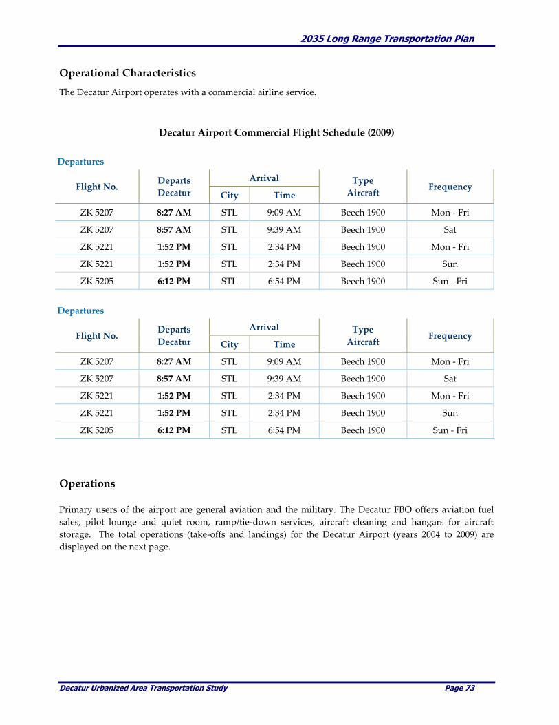
2035 Long Range Transportation Plan
Decatur Urbanized Area Transportation Study Page 73
Operational Characteristics
The Decatur Airport operates with a commercial airline service.
Decatur Airport Commercial Flight Schedule (2009)
Departures
Flight No. Departs
Decatur
Arrival Type
Aircraft Frequency
City Time
ZK 5207 8:27 AM STL 9:09 AM Beech 1900 Mon - Fri
ZK 5207 8:57 AM STL 9:39 AM Beech 1900 Sat
ZK 5221 1:52 PM STL 2:34 PM Beech 1900 Mon - Fri
ZK 5221 1:52 PM STL 2:34 PM Beech 1900 Sun
ZK 5205 6:12 PM STL 6:54 PM Beech 1900 Sun - Fri
Operations
Primary users of the airport are general aviation and the military. The Decatur FBO offers aviation fuel
sales, pilot lounge and quiet room, ramp/tie-down services, aircraft cleaning and hangars for aircraft
storage. The total operations (take-offs and landings) for the Decatur Airport (years 2004 to 2009) are
displayed on the next page.
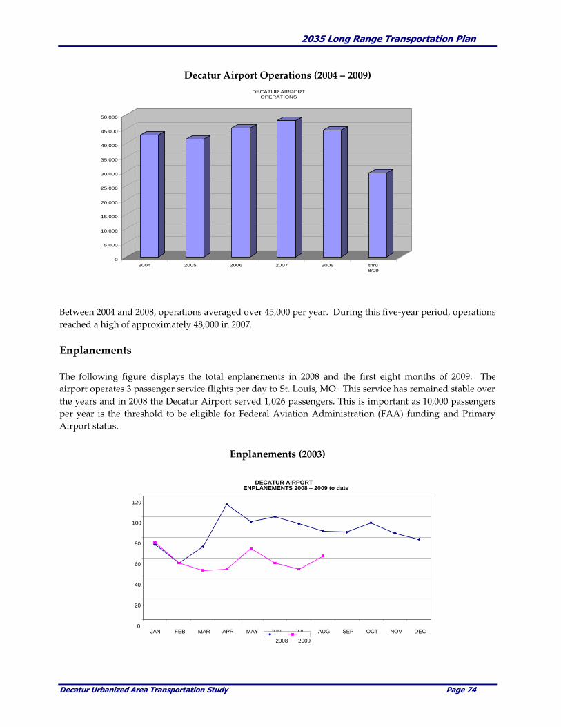
2035 Long Range Transportation Plan
Decatur Urbanized Area Transportation Study Page 74
Decatur Airport Operations (2004 – 2009)
Between 2004 and 2008, operations averaged over 45,000 per year. During this five-year period, operations
reached a high of approximately 48,000 in 2007.
Enplanements
The following figure displays the total enplanements in 2008 and the first eight months of 2009. The
airport operates 3 passenger service flights per day to St. Louis, MO. This service has remained stable over
the years and in 2008 the Decatur Airport served 1,026 passengers. This is important as 10,000 passengers
per year is the threshold to be eligible for Federal Aviation Administration (FAA) funding and Primary
Airport status.
Enplanements (2003)
0
5,000
10,000
15,000
20,000
25,000
30,000
35,000
40,000
45,000
50,000
2004 2005 2006 2007 2008 thru
8/09
DECATUR AIRPORT
OPERATIONS
DECATUR AIRPORT
ENPLANEMENTS 2008 – 2009 to date
0
20
40
60
80
100
120
JAN FEB MAR APR MAY JUN JUL AUG SEP OCT NOV DEC 2008 2009

2035 Long Range Transportation Plan
Decatur Urbanized Area Transportation Study Page 75
Intermodal Characteristics
The surrounding land uses around the Decatur Airport are compatible with air service. In particular, close
access to the Business Industrial Park is very beneficial. As part of the airport layout plan there is the
possibility of a CSX rail spur to serve the industrial park. This would likely occur if the industrial park
occupant needed rail service.
Accessibility
The Decatur Airport is located on the eastern edge of the city and can be accessed via U.S. Route 36, IL
Route 105, and IL Route 121. There is no direct access to the airport by interstate or other limited-access
highways. The SE Beltway is a potential improvement that would benefit the industrial park on Park
District property by providing increased accessibility for passengers, commercial vehicles and other airport
users.
DPTS provides fixed-route bus service to the Airport via Route #12–Airport– Wal-mart East. This route
provides connection with the Severns Transit Center located in Decatur’s CBD. Travel time is
approximately 19 minutes between the two locations. The following chart shows the schedule of Route
#12.
Route #12 Service to Decatur Airport
Leave Arrive Leave Arrive
Transit Decatur Decatur Transit
Center Airport Airport Center
5:32 (A) 5:57 5:46 6:13
6:15 6:51 6:34 7:10
7:15 7:51 7:34 8:10
8:15 8:51 8:34 9:10
9:15 9:51 9:34 10:10
10:15 10:51 10:34 11:10
11:15 11:51 11:34 12:10
12:15 12:51 12:34 1:10
1:15 1:51 1:34 2:10
2:15 2:51 2:34 3:10
3:15 3:51 3:34 4:10
4:15 4:51 4:34 5:10
5:15 5:51 5:34 6:10
6:15 6:51 6:34
7:10
SOURCE: Decatur Public Transit. C:\My Documents\Jim Work\Decatur LRTP\[tables.xls]Transit_Aiport Connection
Shaded area denotes P.M. service. (A) Does not operate on Saturday.
OUTBOUND INBOUND

2035 Long Range Transportation Plan
Decatur Urbanized Area Transportation Study Page 76
Recent Improvements
Within recent years, the Decatur Airport has had a number of improvements totaling nearly $13.5 million.
Those improvements are shown below.
Project name Estimated Cost Status Year
ARFF vehicle & reimbursement
for land parcel $1,053,000 Complete 2007
Taxiway G – Phase II $2,780,000 Complete 2006
Reconstruct & Widen Taxiway C $2,125,000 Complete 2006
Reconstruct portion of runway 6/24
& portions of Taxiways A & C $ 887,000 Complete 2007
Pavement Rehabilitation –
South T-hangar area $ 493,000 Complete 2006
Reconstruct South Perimeter Road $ 114,000 Complete 2006
I Fly Project $2,062,500 Complete 2004
Airport Master Plan $ 282,000 In Progress 2007
Snow Removal Equipment $ 529,000 Complete 2008
Rehabilitate Taxiway A & Ramp $ 869,000 In Progress 2008
ARRA – Reconstruct intersection
of Runways 6/24 & 12/30 $ 792,000 Complete 2009
Construct a Water Main $ 357,000 In Progress 2009
Snow Removal Equip. & Accessories $ 417,000 In Progress 2009
Acquire land for Approach protection $ 336,000 In Progress 2009
Partial fence replacement $ 226,000 In Progress 2009
TOTAL $13,322,500
Source: Decatur Airport, September 2009
The Decatur Airport has constructed a new taxiway (Taxiway G) at a total cost of $6.5 million. This project
was the largest construction project in Decatur Airport history. The project began in the Fall 2003 and
completed in Spring 2005. Taxiway G provides a full-length parallel taxiway to the primary Runway 6/24.
In 2000, the runway strength was increased to allow larger planes to use the airport. As a result, UPS was
able to begin operating B757 service as opposed to B727 service that they had been using. The
improvements also included a longer runway and wider runway needed to accommodate larger aircraft.
In terms of airport accessibility, a study was recently conducted to evaluate a Twin Bridge Road
Connection that would improve the connection between the airport/business park and US 36.
AIP Proj. # 3-17-0033-27
2035 Long Range Transportation Plan
Decatur Urbanized Area Transportation Study Page 77
CHAPTER 4. FUTURE CHALLENGES & OPPORTUNITIES
This chapter summarizes the future challenges and the opportunities to the year 2035. During the LRTP
update period, potential and future conditions within the MPA were reviewed. Year 2030 population and
employment projections were reviewed.
Projected 2035 Population and Employment
Two population and employment (land use) scenarios were developed for the purpose of this LRTP. The
first scenario was a continuation of recent population and employment trends (baseline scenario). The
second represented a higher population and employment growth scenario within the MPA (growth
scenario). During the development of the Macon County – Decatur Comprehensive Plan, relative
comparisons between the baseline and growth scenarios for Macon County and the MPA were reviewed. It
was determined that the baseline estimates, projections and scenarios used in 2004 were valid and would
be used for this LRTP.
With a forecast of limited growth, limited resources, uncertainty of the reauthorization bill and the goal of
limiting growth outside the urban areas, the scenario models used in the 2030 LRTP were not used for 2035
LRTP or the transportation improvements proposed through 2035.
There have been no significant changes in population and employment bases or locations. While some
businesses have ceased to exist, others have opened. In some cases land use has changed, but again the
new land use was deemed to be of equal or roughly equal to the previous use in terms of traffic generation.
An example of the latter would be the former site of Mound Middle School at the southwest corner of BR
51 and Mound Road. The site is now known as Mound Center, which currently includes a Target store and
other commercial businesses. In the process of the land use change, intersection and roadway segments
were improved significantly.
In reviewing the future year population, the review showed the MPA population continuing to increase at
a faster rate than the rest of Macon County. In 2000, the MPA accounted for approximately 92% of the
Macon County Population. This trend is likely to continue through the planning period, which would
result in the MPA continuing to grow at a higher rate compared to the Macon County population.
Based on the baseline scenario population projections, Macon County would have approximately 118,600
persons in the year 2035. Approximately 110,300 would be located in the MPA. It was assumed that the
MPA would continue grow at a faster rate than the Macon County population outside of the MPA.
Employment projections to the year 2035 were also reviewed for Macon County and the MPA. Unlike
population data, it is very difficult to find reliable and accurate employment data/projections. Therefore,
the employment projections were based on the actual and projected population data using an employment-
to-population ratio.
Using the employment-to-population ratios the future year Macon County employment was estimated.
The MPA employment was also needed so an MPA-to-County employment ratio was used. For the
purpose of this study, it was estimated that approximately 96% of the Macon County employment fell
within the MPA. It was further assumed that with each five-year interval that the MPA-to-County ratio
increased by 0.2. Similar to the population projections, this slight increase in the ratio assumes that a
higher percentage of the overall County employment falls within the MPA. It is estimated that Macon
County would have an employment total of approximately 60,500. Of this total, approximately 59,000 of

2035 Long Range Transportation Plan
Decatur Urbanized Area Transportation Study Page 78
these jobs would be located within the MPA.
Potential Transportation Improvements
The year 2035 population and employment projections for the MPA are a gauge to assist in evaluating
future year transportation conditions and potential transportation needs. Population and employment are
the two variables used to project future year traffic levels that are then used to identify capacity and other
transportation related deficiencies. Potential transportation improvement projects were identified by the
DUATS Technical Committee and approved by the Policy Committee. They were evaluated to determine
how effective the potential improvements are in addressing possible transportation infrastructure
deficiencies.
The following sections summarize the potential transportation improvements being considered over the
next twenty-five years within the DUATS MPA.
Roadways
Three transportation improvement scenarios (committed, planned, and future projects) were identified for
analysis as part of the 2035 LRTP. These scenarios attempt to address future year transportation
deficiencies. The potential roadway improvement scenarios were defined as follows:
Committed Projects1 – For the purpose of this LRTP, committed projects are transportation
improvements that are planned and likely to be constructed by 2013. These projects are fiscally
constrained and closely correlate to the current TIP. The term “fiscally constrained” means that
funding for a particular project is available or fully funded, the source of funding is known and
has been committed by the sponsoring entity and it has been programmed in the applicable TIP.
Planned Projects – For the purpose of the LRTP, planned projects are transportation
improvements that are either planned, or desired, to be in place between the years 2013 and 2035.
These projects may have some, but not all of the necessary funding available. Since they are not
fiscally constrained or fully funded, they are included in this LRTP as Illustrative Projects.
Future Projects – For the purpose of the LRTP, future projects are defined as potential
transportation improvements that may be constructed after the year 2035. These projects have no
known funding source and are Illustrative Projects.
The potential committed, planned and future transportation projects are summarized in Chapter 11.
1 The term “Committed Projects” does not guarantee that these projects will be constructed. The term is used for the
purpose of this LRTP to describe potential transportation improvements that could become part of the recommended
transportation improvements as contained in the TIP.

2035 Long Range Transportation Plan
Decatur Urbanized Area Transportation Study Page 79
Transit Operations
Within recent years, two comprehensive transit studies evaluating fixed-route and paratransit service
within the Decatur Urbanized Area have been completed. Based on these studies, the DPTS implemented
service changes including a restructuring of the fixed-route system. The DPTS constantly monitors service
performance and when appropriate will make modifications to better serve the needs of the community.
In terms of potential transit improvements, no significant improvements have been identified beyond the
normal vehicle replacement plan. Table 4-3 identifies the vehicle replacement schedule anticipated by the
DPTS over the next twenty-five years. Additional improvements (i.e., extended night service, modified or
new routes, etc.) are evaluated as the need arises with implementation tied very closely to available
funding.
Transit Improvements
Vehicle Estimated
Type Improvement Description Year
Buses 4 Replacement 35' Low Floor Buses 2010
7 Replacement 30' Low Floor Buses 2013
6 Replacement 30' Low Floor Buses 2017
5 Replacement 30' Low Floor Buses and
4 Replacement 35' Low Floor Buses 2023
7 Replacement 30' Low Floor Buses 2027
6 Replacement 30' Low Floor Buses 2031
Trolleys 2 Replacement Trolley Replica Coaches 2016
Wheelchair-Lift Vans 2 Replacement Light-Duty Wheelchair-Lift Vans 2010
2 Replacement Light-Duty Wheelchair-Lift Vans 2013
2 Replacement Light-Duty Wheelchair-Lift Vans 2016
2 Replacement Light-Duty Wheelchair-Lift Vans 2019
2 Replacement Light-Duty Wheelchair-Lift Vans 2022
2 Replacement Light-Duty Wheelchair-Lift Vans 2025
2 Replacement Light-Duty Wheelchair-Lift Vans 2028
2 Replacement Light-Duty Wheelchair-Lift Vans 2031
2 Replacement Light-Duty Wheelchair-Lift Vans 2034
---------------------------------------------------------------------------------------------------------------------
SOURCE: Decatur Public Transit System, August, 2009

2035 Long Range Transportation Plan
Decatur Urbanized Area Transportation Study Page 80
Bicycles
In 1999, DUATS adopted the Decatur Urbanized Area Comprehensive Bicycle Plan, 1996-2016. It and the
Metro Area Greenways Plan are currently being updated and will be merged into one planning document.
It should be completed by the end of FY 2010. The plan is intended to provide priorities to local
governments and bicyclists on ways to enhance the bicycle as a mode of transportation in the MPA.
DUATS, Decatur Park District, Decatur Bike Club, other local agencies and interested persons will be
reviewing the projects outlined in this plan and concur on their currency. The challenge to expanding the
bike/pedestrian network will be funding. The new document is intended to be adopted by DUATS and
incorporated by reference in the LRTP.
Future enhancement projects within the MPA include the completion of a connecting trail system. This
system includes the Stevens Creek corridor and a trail around Lake Decatur that would connect to the
Fairview Park and Rock Springs trails. These trails are planned to eventually tie into other trail systems as
demand and financing allows.
The trail designed for the Stevens Creek corridor is of utmost importance. The right of ways have been
acquired or land purchased, the construction engineering has been completed and work is ready to begin
on Phase 1 (Fairview to Greendell Parks) as soon as final funding is secured. The trail facility around Lake
Decatur is of very high importance as the Lake is focused for recreational development in the near future.
And connections between existing trail segments are also priorities.
Rail Operations
The majority of rail improvements within the MPA are the responsibility of the individual rail companies.
The most typical improvements consist of maintenance of at-grade rail crossings. More significant
improvements could include the construction of grade separated facilities to separate rail and vehicular
traffic. At this point in time the rail companies and local agencies have not identified any significant
improvements within the MPA.
Aviation
The Decatur Park District identified improvement projects to be included in the 2035 LRTP. These projects
were identified in October 2009, for implementation on a schedule yet to be determined. Land acquisition
is considered an on-going process with no-time frame identified.
The improvements include a new entrance road connection, business/industrial park infrastructure,
lengthening the primary runway, new runway lighting, a second cargo apron and lengthening the
secondary runway.

2035 Long Range Transportation Plan
Decatur Urbanized Area Transportation Study Page 81
CHAPTER 5. SYSTEM SAFETY
The SAFETEA-LU specifies that our transportation planning processes for the MPA “must address the
many challenges facing our transportation system today – challenges such as improving safety, reducing
traffic congestion, improving efficiency in freight movement, increasing inter-modal connectivity, and
protecting the environment – as well as laying the groundwork for addressing future challenges.
SAFETEA-LU promotes more efficient and effective Federal surface transportation programs by focusing
on transportation issues of national significance, while giving the State and local transportation decision
makers more flexibility for solving transportation problems in our community. We are required to carry
out a continuing, cooperative, and comprehensive transportation planning process that provides for
consideration and implementation of projects, strategies, and services that will increase the safety of the
transportation system for motorized and non-motorized users.” DUATS adopted the following objectives
in addressing safety in the MPA:
• To increase transportation system safety through improved facilities, vehicles, education, and training of
the user,
• To promote implementation of transportation improvements that reduce crashes, and
• To identify and monitor/protect vital elements in the transportation network through the use of ITS
advancements.
SAFETEA-LU continues a strong fundamental core formula program emphasis coupled with targeted
investments. One of these areas is Safety. SAFETEA-LU establishes a new core Highway Safety
Improvement Program that is structured and funded to make significant progress in reducing highway
fatalities. It creates a positive agenda for increased safety on our highways by almost doubling the funds
for infrastructure safety and requiring strategic highway safety planning, focusing on results. Other
programs target specific areas of concern, such as work zones, older drivers, and pedestrians, including
children walking to school, further reflect SAFETEA-LU's focus on safety.
Since its inception, and through ISTEA and TEA-21, DUATS has maintained compliance with these
mandates by completing documents such as the Long Range Transportation Plan (LRTP), Transportation
Improvement Program (TIP), and the Unified Work Program (UWP). With every reauthorization bill,
however, new rules and practices are promoted which require DUATS and other government agencies to
review their existing documents and make changes that renew compliance. Safety was one of the elements
which needed to be revised according to the new regulations.
Although Safety was discussed in the 2030 LRTP, meeting the requirements contained in SAFETEA-LU
mandates DUATS to detail certain safety planning activities.
Safety Goals
Safety of the transportation system has always been a large concern for DUATS. Ensuring safe and reliable
conditions for all users of the transportation system has lead to many of the current initiatives in place.
However many more safety concerns need to be addressed in the long term future of the region.

2035 Long Range Transportation Plan
Decatur Urbanized Area Transportation Study Page 82
Motorized Transportation Safety Goals
Reduce the number of traffic related deaths and severe crashes
Reduce the number of teen deaths due to vehicular crashes
Educate the public of the dangers of the transportation system
Encourage all vehicular users to utilize safety belts and appropriate safety restraint devices
Increase work zone safety
Provide safe and accessible transit stops throughout the urbanized area
Have accurate and detailed safety data to measure performance of the transportation network for
motorized transportation.
Incorporate the Transit System Safety Program Plan into metropolitan transportation plans.
Complete and then monitor the TIP and STP-U project selection criteria to ensure that safety
concerns are a high priority.
Non-Motorized Transportation Safety Goals
Increase pedestrian and bicyclist safety by reducing the conflict with vehicular traffic in areas of
high pedestrian or bicyclist volumes
Increase and accommodate pedestrian and bicyclist safety by improving intersection design,
markings and signage,
Increase safety by promoting new sidewalks and bicycle and pedestrian trails in areas and along
urban streets and roads where no such facilities exist and through the creation and improvement of
crosswalks.
Increase pedestrian safety by continuing to maintain and expand street lighting and sidewalk
system signs in all areas
Establish a sidewalk priority system that provides safe routes to schools in all new neighborhood
developments, as well as working to retrofit older, existing neighborhoods.
Have accurate and detailed safety data to measure performance of the transportation network for
non-motorized transportation
Encourage adequate pedestrian facilities so that it enhances the pedestrian environment and
facilities access between destinations
Further incorporate pedestrian and bicyclist into the DUATS organization
Update and expand the Metro Greenways Plan which established a regional trails system
Encourage non-motorized activities for daily commutes.
Safety Planning Activities
All transportation improvements, policies, and activities listed in this plan consider safety. Efforts to
increase safety within DUATS will indirectly be carried out through long-range and short-range planning
activities involving multiple jurisdictions. Examples of such activities include:
Reduce the number of traffic related deaths to less than or equal to a rate of 1.0 fatality per 100
million vehicle miles traveled (100M VMT) by 2011.
The State of Illinois “Five Percent Plan” required by SAFETEA-LU will also be included as input in
the identification of key projects to advance traveling safety in the urbanized area.
Every two years, DUATS will produce an Intersection Location Crash Report with specific
information on fatal injury and property damage for those 20 intersections in the urbanized area

2035 Long Range Transportation Plan
Decatur Urbanized Area Transportation Study Page 83
which had the highest number of fatalities, those which have had the most bodily injury and those
that have had the highest property damage, in dollar amount.
DUATS will work closely with all the safety stakeholders to find and implement safety measures to
reduce traffic related fatalities.
Study how existing bicycle facilities and bus stops can be realigned to reduce conflicts, especially in
downtown areas.
Target improving at-grade rail road crossings to grade-separated facilities near major intersections.
Study the feasibility of on-street striped and marked bike lanes and their inclusion in the urbanized
area transportation system.
Encourage the provision of sidewalks on both sides of the street along with pedestrian refuge
islands for crossing wide streets as well as clearly marked crosswalks with special lighting for
visibility.
Encourage traffic calming, narrow lane widths, etc., on appropriate streets to reduce the speed of
motor vehicles.
Encourage urban design which Increases pedestrian safety by maintaining and expanding street
lighting and sidewalk systems in all areas.
Encourage adequate pedestrian facilities in new developments that enhance the pedestrian
environment, and facilitate access between destinations.
Increase pedestrian safety by encouraging the reduction of vehicular traffic in areas with high
pedestrian volumes, by providing incentives for motorists to carpool or use alternative
transportation modes.
Increase pedestrian safety by encouraging measure such as improving intersection markings and
signage, especially in downtown areas, by installing accessible pedestrian signals where appropriate,
and by implementing consistent crosswalk markings that are indicative of bicycle or pedestrian
passage throughout the urbanized area.
Increase pedestrian safety by supporting local jurisdictions in improving intersection design to
better accommodate pedestrians.
Coordinate with local agencies in promoting a sidewalk system that provides safe routes to schools
in all new neighborhood developments, and retrofitting existing neighborhoods where feasible,
including coordination of Safe Walking Route maps developed by local school districts.
DUATS completed the provisions of its agreement with the Illinois Department of Transportation by
providing geo-coded database services which located all K (fatal) and A (serious injury) crashes within
Macon County for the period of 2001 - 2004. In cooperation with the Macon County Sheriff’s Office,
Decatur Police Department and other law enforcement agencies, DUATS continues to locate crash data on
the DUATS database system for all of Macon County. This information provides a single GIS data layer
containing all crash information. The information is used by local engineers and officials to identify
locations with a high likelihood of crashes. This data is proving to be an excellent resource by providing
area, site and municipality specific maps showing crashes. Having this historical data aids in
understanding crash location clusters, the dynamics which contributed to the crash and other correlations.
This data is also used to identify sights that need further review and engineering work.
Desired Outcomes and Performance Measures
DUATS has developed maps and associated databases which visually display historical crashes by year
and type, ADT counts, vehicle type, high crash locations and is using this data to compare of crash rates by
fatal and non-fatal crashes to road type, ADT, mitigating circumstances, if any, adjacent land uses,
road/street and access design and other analytical means, to obtain reductions in traffic related injuries and
or deaths in the MPA.

2035 Long Range Transportation Plan
Decatur Urbanized Area Transportation Study Page 84
CHAPTER 6. SECURITY
Background and Introduction
The Safe, Accountable, Flexible, Efficient Transportation Equity Act—A Legacy for Users (SAFETEA-LU)
addresses the challenges facing our transportation system today – challenges such as improving safety and
security, reducing traffic congestion, improving efficiency in freight movement, increasing intermodal
connectivity, and protecting the environment – as well as laying the groundwork for addressing the future.
SAFETEA-LU promotes more efficient and effective Federal surface transportation programs by focusing
on transportation issues of national significance, while giving State and local transportation decision
makers more flexibility for solving transportation problems in their planning areas.
SAFETEA-LU continues a strong fundamental core formula program emphasis coupled with targeted
investment. One of these areas is Security, which is one of the eight Planning Factors noted in Sec. 450.306
of the February 14, 2007 regulations. The regulations state that the metropolitan transportation planning
process shall provide for consideration and implementation of projects, strategies, and services that will
address increasing the security of the transportation system for motorized and non-motorized users.
Since its inception DUATS has endeavored to maintain compliance with these mandates by completing
documents such as the Long Range Transportation Plan (LRTP), Transportation Improvement Program
(TIP), and the Unified Work Program (UWP). With every reauthorization bill, however, new rules and
practices are promoted which require MPOs and other government agencies to review their existing
documents and make changes that renew compliance. Security was one of the elements which needed to be
addressed/revised according to the new regulations.
SAFETEA-LU calls for the security of the transportation system to be a stand-alone planning factor,
signaling an increase in importance from prior legislation, in which security was coupled with safety in the
same planning factor. In NCHRP Report 525, Surface Transportation Security, Volume 3, Incorporating Security
into the Transportation Planning Process, a survey among MPOs showed that the following focus areas have
been identified with respect to transportation Security:
Traffic modeling for evacuation plans
Airport facility planning
Emergency preparedness
Statewide assessments of critical assets and vulnerable facilities
Coordination with emergency responders
NCHRP Report 525 makes the following distinction between safety and security:
Safety – protection of persons or property from unintentional damage or destruction caused by accidental or natural
events
Security – protection of persons or property from intentional damage or destruction caused by vandalism, criminal
activity, or terrorist events
The report suggests the following provisions to incorporate security into the transportation planning
process:
Make security a distinct factor from safety in the transportation planning process

2035 Long Range Transportation Plan
Decatur Urbanized Area Transportation Study Page 85
Provide resources for transportation-related homeland security projects that would be identified
through the regular transportation planning process, including those aimed at prevention, mitigation,
response and recovery
Provide resources to improve international freight security in and around key freight gateways and
hubs, including intermodal and Strategic Highway Network STRAHNET connectors.
Provide resources to expedite urgent highway and public transportation security projects to address
imminent damage or to repair damage caused by a terrorist attack against the United States, including
structural hardening, relocation of roads from underneath critical structures, property acquisition to
create secure zones, or repairing or replacing a bridge or tunnel that has been damaged or destroyed
by a terrorist attack.
Encourage the use of monitoring systems (such as Intelligent Transportation Systems [ITS]) to check
the status or condition of key surface transportation (highway and transit) facilities.
Inclusion into the planning process of security related stakeholders such as local law enforcement
agencies, fire departments and rescue squads, federal response agencies, and the Department of
Homeland Security (DHS).
Addressing the Gaps in Security
SAFETEA-LU incorporated a new stand-alone factor to “increase the security of the transportation system
for motorized and non-motorized users”. DUATS needs to continue to study, create and establish relevant
and specific goals, objectives and anticipated outcomes regarding existing and anticipated security and
public safety issues.
Review current statewide and metropolitan transportation plans for emergency planning/security
elements
Develop security goals and appropriate strategies in conjunction with the Macon County Emergency
Management Agency (MCEMA).
Continue to work with the Decatur Public Transit System (DPTS) to formulate appropriate security
planning. The DPTS Security Program Plan (SPP) is anticipated to be completed prior to October 1,
2007. DUATS will work with DPTS to incorporate the SPP into the State and local transportation
planning process.
Define the role of the DPTS, DUATS and the State in promoting security,
The MCEMA, a multi-jurisdictional entity, has in place a comprehensive evaluation of all critical
facilities and has identified security and safety issues with regard to the various transportation system
modes, including the public transit system, rail and freight carriers, airport, interstate system, NHS
routes, and STRAHNET routes in the County. Potential security threats and the response to matters of
security and public safety are contained in the Emergency Operations Plan (MCEOP), HazMat
Appendix.
DUATS needs to address the following objectives with eventual incorporation in the 2030 LRTP:
Consider, again, the need and possible benefit of developing a regional Intelligent Transportation
Systems (ITS) plan that outlines stakeholders, their responsibilities and functions, and identifies
projects that facilitate safety, security, and the dissemination of information.
The MCEMA has an adopted plan for the MPA and the County that details hazardous material
transport routes and planned actions which will be taken in the event of spillage, theft, or other
occurrence that threatens public safety, public resources or infrastructure. The response planning is
contained in the SPP, Containment Appendix.

2035 Long Range Transportation Plan
Decatur Urbanized Area Transportation Study Page 86
Emergency management personnel are continually invited to review and comment on public safety,
general security and vehicle access as it related to new roadway construction and proposed
developments or redevelopment areas.
The MCEMA currently has in place plan(s) that details emergency routes and evacuation procedures at
the County level.
Educate the public about how they should use the area transportation system in case of an emergency
and/or disaster.
Changes to the LRTP Regarding Security
The following steps are being undertaken to incorporate security as a stand-alone factor in the long-range
transportation planning process and also to be in compliance with SAFETEA-LU:
Incorporate security into the LRTP mission statement.
To provide a safe, secure, efficient, and economical transportation system that makes the best use of existing
infrastructure, optimizes mobility, promotes environmental sensitivity, accessibility, and economic
development, and enhances quality of life for all users.
Address security as a stand-alone factor in the list of planning factors
Update security goals and objectives.
During the review and update of the 2030 LFTP, the following six areas were reaffirmed regarding
implementation of the security goals in the 2035 LRTP.
The Macon County Emergency Management Agency (MCEMA) is the responsible entity regarding security
planning, public safety and incident control. DUATS will work with MCEMA to address issues involved
with developing a system wide transportation security plan.
MCEMA has a comprehensive list of identified or potential security targets in the transportation
infrastructure for the whole of Macon County. This information was created and is maintained in
the GIS database.
MCEMA has identified security targets outside of the transportation infrastructure.
MCEMA has identified hazardous material transport routes, which may be found in the SPP,
HazMat Annex.
MCEMA has developed security event scenarios which are evaluated at the conclusion of the
Annual Exercise Program.
A GIS data stream has been developed which sets in place the prevention, protection, recovery and
redundancy strategies for security event scenarios.
Within the next three (3) moneys incorporate the Transit Authority’s Emergency Response &
Disaster Plan.
DUATS will revisit the need and potential benefit(s) of developing a regional Intelligent Transportation
Systems (ITS) architecture plan as a tool to coordinate and Implement security strategies for the
transportation system.
Study the benefits of creating an ITS architecture plan.
Implement transportation security related projects through the ITS architecture plan.
Coordinate DUATS member agencies and other stakeholders in implementing transportation
system security strategies using the ITS architecture plan as a framework.
Incorporate security features in transportation system design.
2035 Long Range Transportation Plan
Decatur Urbanized Area Transportation Study Page 87
Consult the American Association of State Highway and Transportation Officials (AASHTO)
guidelines on turning radii, street dimensions, and other factors that relate to emergency vehicles
and their ability to traverse roadways.
Continue to consult local fire departments and other emergency operations and management
personnel early in planning and design phases where emergency vehicle access, public safety and
resource security might be an issue.
Plan pedestrian and bicycle facilities in secure areas and provide proper lighting.
Consider security requirements with respect to surveillance, detection, containment, and
emergency response when planning and designing transportation projects.
Provide complete transit security for both transit users and infrastructure.
Install surveillance cameras, alarms and radio communications on all transit buses.
Install surveillance cameras, alarms and security gates for transit facilities.
Install shelters, lighting, emergency phones and surveillance for bus stops.
Train transit employees to identify security threats and handle security events.
Continue to work with MCEMA in maintaining and enhancing the Emergency Plan, HazMat Appendix,
and to continually monitor the system of emergency and evacuation routes which has been chosen for the
region.
Consult with MCEMA and local governments within urbanized area to determine the current
system.
Determine what changes need to be made to the system so that consistency is prevalent.
Identify bottle necks on evacuation routes that could hinder response and recovery.
Implement strategies to overcome bottlenecks.
Implement public transit as a mode for evacuation.
MCEMA has developed a system of public information dissemination infrastructure for managing security
events as contained in the EOP, Public Information Appendix, which may eventually include the following:
Install evacuation route signs.
Identify critical route choice decision-making locations and study the benefit of installing dynamic
message signs which can be suited to specify relevant information during a security event.
Create relevant materials that can be disseminated proactively and at the time of emergency-based
on coordination of member agencies and other local agencies.
Desired Outcomes and Performance Measures
In cooperation with the Macon County Emergency Management Agency (MCEMA), local law enforcement
agencies, health and other emergency responders, DUATS will maintain or have access to various texts,
tables, charts, figures, graphs, maps and other data which has been collaboratively collected, verified and
maintained which will support the goals and objectives of protecting the public safety, providing disaster
assistance and protection of personal and public property, infrastructure and other assets. The texts, tables,
charts, figures, graphs and maps would display, at a minimum, data that includes:
MCEMA maintains a comprehensive list of critical and potential targets including public
resources, critical care facilities, transportation infrastructure facilities. These facilities and
corresponding attributes are maintained on the County GIS network. Permissions are being

2035 Long Range Transportation Plan
Decatur Urbanized Area Transportation Study Page 88
negotiated for DUATS staff to access non-sensitive, personal or confidential information for
transportation planning purposes.
At least every two (2) years, DUATS will study the cost and benefit of implementing a regional
Intelligent Transportation Systems (ITS) Architecture Plan.
A an update to the DUATS and DPTS Security Plan was completed in 2007. It includes a list of
security elements that have been identified and the measures and procedures which will be
implemented.
GIS will continue to be used for a number of Security purposes, such as emergency vehicle routing,
transit vehicle routing, computer aided dispatch, and evacuation planning.
The Illinois Emergency Management Agency (IEMA) is responsible for coordinating mitigation,
preparation, response and recovery operations during disasters in the State of Illinois which affect
land beyond the boundaries of Macon County. IEMA’s central office is in Springfield, IL. There are
8 regional offices.
Illinois Homeland Security, located in Springfield, is the statewide wing of the Department of Homeland
Security. The mission of this organization is for a better prepared state of Illinois in homeland security. This
agency coordinates with other federal and state agencies such as Illinois Terrorism Task Force (ITTF),
Illinois Department of Public Health (IDPH) etc., in dealing with security related incidents in the state. The
ITTF has divided the state into twelve regions based on six criteria: population, existing state and regional
response divisions, existing technical and specialist local regional and state response teams, critical
infrastructure, minimum response times, and in depth regional and statewide coverage.

2035 Long Range Transportation Plan
Decatur Urbanized Area Transportation Study Page 89
CHAPTER 7. ENVIRONMENTAL MITIGATION
A few years ago, federal transportation program authorizing legislation required that environmental
impacts and mitigation become part of the long range metropolitan transportation planning process. The
new requirements concern environmental mitigation activities. These regulations call for a discussion of
potential environmental mitigation activities and potential areas to carry out these activities. This
discussion may focus on policies, programs, or strategies rather than specific project levels actions.
Environmental considerations must be an integral part of transportation planning and design. All projects
that include Federal funds, whether under state or local jurisdiction are administered by the Illinois
Department of Transportation (IDOT) and must adhere to all state and federal environmental laws. Thus
the majority of transportation projects require a plan to protect the natural and social environment
surrounding these projects. IDOT has taken a proactive approach to preserving and protecting the
environment in the face of constructing transportation projects. Because quality of life is vitally important
to the citizens of the County, DUATS incorporates environmental mitigation policies and strategies in
making transportation improvements. DUATS continues to foster positive relationships with
environmental groups, government agencies and the public at large when discussing infrastructure
projects and has worked to make part of the transportation planning process.
Environmental Goal
DUATS is committed to wise stewardship of transportation planning dollars and effective decision
making, including project selection, which will be integrated and coordinated with land use, water, and
natural resource planning and management. The Macon County – Decatur Comprehensive Plan encourages
the establishment of environmental suitability as a key limiting factor in determining the nature and
location of future development. This principle of environmental sensitivity applies to transportation
planning and extension or major modification of the transportation system. The identification of a full
range of environmental concerns will occur early in the transportation planning and project development
process.
To meet these goals, DUATS has developed the objectives listed below:
Maintain a transportation system and support those transportation system improvements that are
environmentally responsible and support conservation of the regions natural, cultural, historic and
aesthetic resources.
Ensure that social, environmental, energy, regional and community, and other non-transportation
goals, plans and programs affecting transportation are considered in all phases of the
transportation planning process.
Identify, implement or support public investment in transportation facilities and services that
effectively address social, environmental and energy goals of the community.
Evaluate innovative methods for mitigating the environmental impacts of transportation facilities
and improvements.
Encourage the shift of new developments that are typically scattered and are primarily vehicle
oriented to areas that are transit and pedestrian oriented, that have existing transportation
infrastructure in place and utilize conservation design techniques.
2035 Long Range Transportation Plan
Decatur Urbanized Area Transportation Study Page 90
Illinois Department of Transportation
Environmental Mitigation Strategies and Procedures
The National Environmental Policy Act (NEPA) requires full disclosure of the impacts that federally
funded transportation projects would cause to the surrounding environment. NEPA also requires that we
first try to avoid impacts to resources. If impacts cannot be avoided, NEPA requires that measures be
taken to minimize those impacts and that compensation or mitigation be provided for those impacts. As
stated in its mission, the Illinois Department of Transportation (IDOT) is to provide safe, cost-effective
transportation for Illinois in ways that enhance quality, promote economic prosperity, and demonstrate
respect for our environment. Based in part on this mission and on the state and federal environmental laws,
IDOT makes every attempt to minimize negative environmental impacts of its projects both during
construction and after completion. IDOT policies, strategies and procedures are specifically designed to
identify potential environmental impacts and to pro-actively take all reasonable steps to ensure the least
environmental disruption or other negative consequences. There are several key areas in which
environmental mitigation activities are focused. The following are the most commonly identified areas:
Section 4(f) Lands
Section 6(f) Land Conversions
Cultural Resources (Historic Properties and Archaeological Sites)
Threatened and Endangered Species (State and Federal) and Natural Areas
Farmlands
Wetlands
Floodplains
Noise Abatement
Air Quality
Section 4(f) Lands Section 4(f) of the USDOT Act of 1966 applies to any USDOT funded project which involves the use of any
significant publicly owned public park, recreation area, or wildlife and waterfowl refuge and any land
from an historic site of national, state or local significance. Special environmental analyses are required to
determine if there is a feasible or prudent alternative to taking the proposed action involving the use of the
4(f) property. In addition, the project sponsor must demonstrate that all possible planning to minimize
harm has occurred. These measures to minimize harm, which include mitigation, will be documented in
the 4(f) evaluation. IDOT, as part of its Bureau of Design and Environment (BDE) manual has procedures
in place for completing 4(f) evaluations that document these findings.
Section 6(f) Land Conversion
Section 6(f) of the Land and Water Conservation Fund Act of 1965 applies to any USDOT funded projects
which involve the use of lands which have Land and Water Conservation (LAWCON) or Open Space Land
Acquisition and Development (OSLAD) funds involved in their purchase or development. IDOT, as part
of its BDE manual has procedures in place for handling 6(f) lands when developing highway projects.
These procedures focus on early and on-going coordination with local officials as well as the Illinois
Department of Natural Resources.

2035 Long Range Transportation Plan
Decatur Urbanized Area Transportation Study Page 91
Cultural Resources (Historic Properties and Archaeological Sites) When IDOT develops a federal funded/regulated project, appropriate measures are taken to avoid and/or
minimize impacts on properties that are included in/or eligible for the National Register of Historic Places.
Where such properties will be affected, the Advisory Council on Historic Preservation shall be afforded a
reasonable opportunity to comment prior to project approval. Special efforts shall be made to minimize
harm to any National Historic Landmark. The BDE manual contains specific procedures for minimizing
harm to historic resources in cooperation with the Advisory Council on Historic Preservation and the State
Historic Preservation Officer.
Threatened and Endangered Species/ Natural Areas In the development of a project, special studies and coordination are required when the action may affect
Federally-listed threatened and endangered species. Studies and coordination also are required for actions
that may adversely impact State-listed species. IDOT also conducts studies and coordination activities on
actions that may adversely impact areas included in or eligible for the Illinois Natural Areas Inventory. It
is IDOT’s policy that in the development of a project, an assessment shall be made of the likely impacts on
species of plants or animals listed in the Federal and/or State level as threatened or endangered and on
State-designated Natural Areas. Every effort is made to minimize the likelihood of jeopardizing the
continued existence of listed threatened or endangered species or the destruction or adverse modification
of a Natural Area. Efforts are also made to avoid negative impacts on areas of habitat designated as critical
habitat or essential habitat. The BDE manual specifies procedures for avoiding and/or mitigating impacts
on endangered or threatened species and Natural Areas including consultation with the U.S. Fish and
Wildlife Service and the Illinois Department of Natural Resources.
Farmlands In the development of a project, consideration is given to the impacts that the action will cause in
conversion of farmland to non-farm uses. Under certain circumstances, coordination must be initiated
with the U.S. Department of Agriculture, Natural Resources Conservation Service and/or the Illinois
Department of Agriculture to evaluate the impacts on farmland and obtain the views of those agencies on
alternatives to the proposed action. Proposed actions will be developed to be compatible with state, local
government and private programs and policies to protect farmland. The BDE manual outlines
coordination procedures and defines those lands subject to these provisions.
Wetlands Preservation Protection and preservation of wetlands is an important environmental goal of IDOT. In this area,
mitigation efforts are coordinated with other state and federal agencies and are clearly defined in both
policy and procedures.
The Illinois Interagency Wetland Policy Act of 1989 (IWPA) includes the identification and delineation of
jurisdictional wetlands. The Wetlands Group within the Illinois Natural History Survey performs this work
under a statewide contract with the IDOT. Under the CWA (Clean Water Act) and IWPA, the IDOT must
demonstrate that all measures were taken to first avoid and then minimize impacts to wetlands to the
fullest extent practicable. Unavoidable impacts are mitigated by way of wetland compensation through
either restoration or creation of wetlands. Methods used by the IDOT to restore or create wetlands follow
the Illinois Wetland Restoration and Creation Guide. In addition to the INHS Wetlands Group the
Wetlands Geology Section at the Illinois State Geological Survey provides technical assistance to the IDOT
in locating, evaluating and monitoring compensatory wetlands. All IDOT wetland compensation plans
include a commitment to monitor planned wetlands for attainment of performance standards.
Departmental procedures for ensuring compliance with the CWA and IWPA are detailed in the IDOT

2035 Long Range Transportation Plan
Decatur Urbanized Area Transportation Study Page 92
Wetlands Action Plan. There are no Wetland Compensation sites in the Decatur MPA.
Wetland Mitigation Bank Sites The IDOT has also worked closely with the Illinois Department of Natural Resources (IDNR) to establish
two wetland mitigation bank sites, including the 830-acre Morris site located in north-central Grundy
County and the 1640-acre LaGrange site located in extreme northeastern Brown County. At these sites,
wetlands will be restored in advance of unavoidable losses from highway projects. Impacts within the
bank’s approved service area may be mitigated at the bank. Instruments for both bank sites were prepared
in accordance with the Federal Guidance for the Establishment, Use and Operation of Mitigation Banks.
Other agencies involved in the development of these sites included the U.S. Fish and Wildlife Service, the
U.S. Army Corps of Engineers and the U.S. Environmental Protection Agency.
Floodplains In the development of a federally funded project, special requirements are imposed by Executive Order
11988 when the project will entail a significant floodplain encroachment. These requirements are in
addition to floodplain permit requirements and the special hydraulic analyses associated with determining
bridge and culvert heights and widths for projects located in floodplains. A project that will result in
significant floodplain encroachment will require the preparation of an Environmental Assessment or
Environmental Impact Statement. Both the BDE manual and the IDOT Water Quality Manual provide
additional information and procedures for projects involving floodplains.
Noise Abatement Federal laws and regulations require that it is necessary to undertake special technical analyses to identify
and evaluate the potential noise impacts a project will involve. Once a noise impact is identified, IDOT will
evaluate feasible and reasonable noise abatement methods to reduce traffic noise impacts. Traffic noise can
potentially be reduced by addressing the noise source, noise path or noise receiver. The BDE manual
includes specific guidance and procedures for determining the need for noise abatement evaluations and
the types of mitigation strategies that are appropriate for a variety of situations. The manual also specifies
coordination requirements with local government and public participation procedures.
Air Quality All transportation plans, programs, and projects which are funded or approved under Title 23 USC must
be determined to conform with State or Federal air implementation plans as required by the Clean Air
Amendments of 1990 and subsequent federal regulations. Such implementation plans describe how air
quality standards will be achieved in those areas of a State in which standards are being exceeded. This
requirement helps regulate projects and guarantees that any new projects may not cause or contribute to
new violations of air quality standards, exacerbate existing violations, or interfere with the timely
reduction of emissions as reflected in the State Implementation plan.
Illinois has areas in which standards are being exceeded for one or more criteria pollutants.
Transportation-related criteria pollutants include ozone, carbon monoxide, nitrogen dioxide as well as both
particulates and fine particulates (PM 10 and PM 2.5). These pollutants are modeled in non-attainment
areas in order to determine the required conformity with air quality requirements. The Decatur
Metropolitan Planning Are is an attainment area and is in compliance with air quality standards and
within the parameters of transportation related pollutants.

2035 Long Range Transportation Plan
Decatur Urbanized Area Transportation Study Page 93
GIS (Geographic Information Systems) DUATS maintains a comprehensive series of GIS layers and associated databases pertaining to
environmentally sensitive and geographically significant areas. The layers include floodplains, soils
including those which are highly erodible, wetlands, oil and coal fields, conservation and recreation areas,
greenways and brownfield/gray field site maps. The available layers and associated attribute tables
continue to increase and grow more inclusive and accurate as GIS programming is enhanced and
improved.
Layers are typically “laid over” the base map of choice. Normally the base map is aerial imagery or parcel
maps. An infinite number of layers might be applied to the base map. There are different transportation
related layers which can accessed for comparison purposes. By comparing the environmental and
transportation layers at the same time, areas of critical concern and/or environmental incompatibility can
be seen instantly. DUATS’ mapping capabilities allow for immediate notice, for example, if a proposed
road was on an alignment that would cross an environmentally sensitive area or a floodplain. DUATS
cooperatively maintains a timely, state of the art aerial mapping series of at least 6” resolution, in full color
and orthographically rectified. The layers depicting environmentally sensitive and geographically
significant areas are available individually or collectively and are instantly available to be overlain on the
MPA map. A pending intergovernmental agreement between Macon County, Decatur and the Macon
County Soil & Water Conservation District would bring LIDAR (Light Detection And Ranging) to our GIS
system. LIDAR, for example, will be extensively used in applications that require topographic information.
DUATS intends to continue to cooperate and coordinate planning activities with all applicable local, State,
Federal and quasi-public environmental resource agencies.
EcoCat (Ecological Compliance Assessment Tool) is an on-line tool available through the Illinois
Department of Natural Resources which may help determine potential environmental impacts of certain
types of proposed projects. This online tool may be helpful in the early stages of an environmental review
of certain transportation projects. EcoCat can be accessed at http://dnrecocat.il.us/ecopublic.
The map on the following page is an example of environmentally sensitive areas in the MPA. additional
layers are formulated and added as time and opportunity warrant. The map shown is representative and is
for illustrative purposes only.
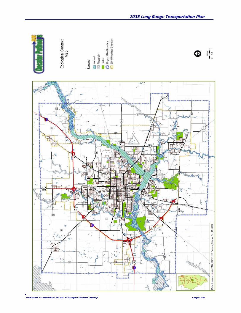
2035 Long Range Transportation Plan
Decatur Urbanized Area Transportation Study Page 94

2035 Long Range Transportation Plan
Decatur Urbanized Area Transportation Study Page 95
Context Sensitive Solutions Issues such as traffic congestion from home to work, suburban sprawl, preservation of scenic landscapes
and historic neighborhoods, and the ability to use our transportation system to walk, bike, and access
public transit are high priorities in terms of what people expect from transportation policy. Context
Sensitive Solutions (CSS), a state requirement for IDOT, aims at addressing these concerns, and making
sure that IDOT’s transportation projects are designed to improve the quality of life for all who have a stake
in the system. Travelers, communities, businesses, elected officials and many others are all "stakeholders"
in our transportation system.
In August of 2005, IDOT implemented their current CSS Departmental Policy requiring that the principles
of CSS be applied to the planning, design, construction and operation of all state projects involving new
construction, reconstruction, and major expansion of transportation facilities. The CSS process works as a
partnership between IDOT and stakeholders to come up with working solutions to our transportation
needs. Stakeholders help IDOT understand their needs for, and concerns about, our transportation system.
IDOT can then take this input, along with all of its other work and analysis, and use it to make planning
and design decisions. The CSS process is also a key way to ensure that appropriate environmental
mitigation activities are considered. A number of DUATS staff have attended CSS training.
Additionally, the development of the Comprehensive Plan includes environmental elements. The creation
of these elements were an integral part of the multiple year comprehensive planning endeavor. This
planning process utilized Context Sensitive Solutions as it continually engaged the public in planning for
the future.
Mitigation Activities During Construction IDOT strives to reduce the negative impacts of highway construction and rehabilitation projects by
requiring contractors to adhere to related provisions in their Standard Specifications for Road and Bridge
Construction. This document includes specific requirements in a number of areas related to the
environment:
Protection of existing plant material
Removal of waste
Temporary erosion control
In addition to these general provisions, some highway projects also include additional construction
mitigation requirements which are consistent with the location and magnitude of the project, the types of
impacted resources and other project specific issues. DUATS encourages, at a minimum, that a
construction monitoring and control program be instituted on major construction projects that focuses on:
Controlling construction dust – watering, street sweeping and chemical dust suppressants
Reducing diesel emissions – emission control devices, cleaner fuels and idling restrictions
Controlling erosion and sedimentation – special equipment and procedures
Reducing noise and vibration – special drilling techniques and low-impact hammers

2035 Long Range Transportation Plan
Decatur Urbanized Area Transportation Study Page 96
CHAPTER 8. OPERATIONS AND MAINTENANCE
Background and Introduction
DUATS is required to include and actively “promote efficient system management and operation” as a
required planning factor in the MPA. Also, DUATS must develop “A *long-range] transportation
plan<shall contain, at a minimum<Operational and management strategies to improve the performance
of existing transportation facilities, relieve vehicular congestion and maximize the safety and mobility of
people and goods.” While federal law and regulation has required some focus on transportation system
management and operations for a number of years, management and operations strategies such as incident
response, special event planning, and work zone management have received relatively little attention.
However, various constraints have highlighted the need for coordination of regional operations strategies
in planning within the MPA. Among the factors affecting new highway and transit infrastructure capacity
are:
Environmental, Community, and Space Constraints – Within the MPA, there are very limited
opportunities for highway or transit capacity expansion along congested corridors. The
environmental and community impacts that would result from new or widened roadways go
beyond what is acceptable. In most cases, there is little or no additional space within public right-
of-ways and physical, privately owned improvements on or near to the existing rights of ways.
These constraints on traditional infrastructure construction will require DUATS to seek new ways
of enhancing the effective capacity and reliability of the existing transportation network.
Funding Constraints - As transportation construction costs have increased, State and local budgets
have become more strained. With limited growth expected within the period covered by the this
LRTP and financial resources being stressed, DUATS plans for very few large scale transportation
capacity projects.. At the time that project costs are increasing, growth potential is limited and
existing infrastructure approaching or exceeding its design life, DUATS and local entities are
facing infrastructure deterioration from years of deferred maintenance. These funding challenges
and physical realities mean that local agencies will be required to spend more time and treasury on
maintenance and rehabilitation of the existing transportation system.
Inability to Respond to Short-term Problems - Major construction projects rarely deliver new
capacity in the short term. In fact, some large-scale projects take well over a decade to complete.
At the same time, transportation patterns are more diverse and less predictable than ever. New
transportation challenges emerge unexpectedly as a result of economic shifts or short-term trends.
Thus, there is a need for transportation solutions that can respond quickly to congestion, safety,
and economic concerns.
DUATS is interested in improving the reliability and operating efficiency of the existing transportation
system. An effective transportation system requires the provision of highway and transit infrastructure for
movement of the public and freight. To a certain extent this requires the efficient and coordinated
operation of the regional transportation network. In order to improve system efficiency, reliability, security
and safety all of the entities, local, regional, State and Federal, must work together to spend the available
funds on transportation improvements which effectively link planning, operations, maintenance and land
use. This linkage is critically important to improving transportation decision-making and the overall
effectiveness and efficiency of our transportation system.
2035 Long Range Transportation Plan
Decatur Urbanized Area Transportation Study Page 97
Planning for Operations “Planning for operations” can be defined as a set of activities with the intent of making investment
decisions and/or establishing and carrying out plans, policies, and procedures that enable and improve
transportation systems management and operation. For a regional transportation system Management and
Operations (M&O) program to be effective, those directly responsible for operating the system must agree
on what measures to use to assess performance, a concept for how the system should be operated on a
regional basis, and how to make changes to achieve desired improvements and efficiencies in system
operating performance.
The statutes and regulations that govern the transportation planning process have the flexibility to
accommodate and, in fact, encourage M&O solutions. It has become clear that MPOs, State DOTs, and
other agencies that lead transportation planning efforts can use the planning process as an important
forum and tool for collaboration between planners and operators. Coordination between planners and
operators helps ensure that regional transportation investment decisions reflect full consideration of all
available strategies and approaches to meet regional goals and objectives.
DUATS’ Management and Operations Goal DUATS’s goal is to link operations and planning of the regional transportation system to solve operational
problems, improve system performance, and improve communication across transportation-related
agencies. There are many programs in the DUATS region that, in order to be successful, must cross
functional and jurisdictional boundaries; examples include corridor signal system coordination, pavement
management, traveler information services, response to weather events, and emergency management.
These programs depend on an unprecedented level of collaboration, coordination, and integration to
achieve optimum performance and truly benefit the region’s residents, businesses and travelers. DUATS
planning for operations at the regional level is therefore a deliberate, collaborative, and coordinated
activity that takes place when transportation agency managers responsible for day-to-day operations work
together at a regional level with transportation planners.
Measuring Performance of the Regional Transportation System One of the critical components in developing regional management and operational strategies is
establishing performance measures. Performance measurement involves the act of developing specific
transportation system performance criteria and quantitatively tracking those measures. Performance
measures have many functions and can be used to:
Identify what attributes of the transportation system are most important
Provide information on current system conditions and performance
Evaluate the success of implemented and on-going projects and programs
Provide a matrix for communicating with decision-makers and the public about past, current, and
expected future transportation system conditions
Serve as criteria for investment decisions made in the transportation planning process
Efforts to focus on system performance often result in better recognition of the value associated with
management and operational improvements. Data on system performance can highlight the value of
investments in programs that minimize incident-related delays, provide information on real-time travel
conditions, and improve emergency response times by showing how they can improve transportation
system reliability and reduce travel times for customers.

2035 Long Range Transportation Plan
Decatur Urbanized Area Transportation Study Page 98
Performance measures can also help link planning and operations by focusing attention on customer-
oriented outcomes and elevating attention to M&O strategies within the transportation planning process.
By focusing attention on system characteristics that are important to the traveling public, the issues faced
by operators such as incident response, work-zone management, and provision of traveler information take
on greater importance. Incorporating these issues into the planning process will help focus DUATS’
planning on those issues which are of the highest importance to the traveling public in the region.
DUATS’ Approach to Management & Operations In order to integrate transportation system M & O into the regional planning process, DUATS will develop
a program that identifies key transportation performance measures of relevance to the region, coordinate
with transportation system operators and providers to collect appropriate data for those measures, compile
and analyze the data and produce reports on the performance of the region’s transportation system. This
information will be used by DUATS to help develop Long Range Transportation Plans and Transportation
Improvement Programs by facilitating the development of more cost-effective and performance-based
transportation investments and actions.
Creation of Performance Measures Performance measures developed for this region will be multimodal (e.g., highway, transit, non-motorized
modes) and address a cross-section of key issues, including congestion, safety, mobility, reliability and
accessibility. As DUATS’ experience and capabilities related to M&O evolve, the number and categories of
performance measures may be expanded to provide additional detail on the performance of the region’s
transportation system for planners, policy-makers and the public.
Performance measures can be grouped into three categories:
Input measures - which generally address the supply of resources;
Output measures - which address the delivery of transportation programs, projects, and services;
and
Outcome measures - which address the degree to which the transportation system meets policy
goals and objectives.
While input and output measures are the easiest to implement, outcome measures focus on the effects that
the traveling public most cares about - issues such as travel time and delay, safety, and reliability.
DUATS will initially focus on a core set of output measures. Using simpler output performance reporting
can inspire the attention and collaboration necessary to design measures that address the most important
aspects of the system performance. As DUATS gains experience and temporal data on various measures, a
blend of both output and outcome measures may be preferable to using either type alone. Output measures
provide an immediate indication of accomplishment for those activities whose benefits accrue over the
long term (i.e., where “outcomes” are not immediately apparent). However, DUATS will attempt to
monitor outcomes over the long term as data and expertise allow.
2035 Long Range Transportation Plan
Decatur Urbanized Area Transportation Study Page 99
Categories of performance measures that DUATS will use to frame development of a set of core regional
performance measures include:
Category Examples of Possible Core Performance Measures
Safety Change in Number of K (Fatal) and A (incapacitating
injury) types of crashes
Change in Number of Crashes/Million Miles Traveled
Pedestrian or Bike Accidents per Year
Number of Traffic Fatalities/Injuries within Region
Congestion & Reliability Change in average travel time between selected origins
& destinations
Total hours of delay in region
Person-miles (or hours) of travel in congested conditions
Travel Time Index
Accessibility & Mobility Percent of region’s population within ¼-mile (OR 15
minute walk distance) of transit services
Total transit ridership OR transit mode share
Number of access permits granted on congested
roadway segments
Environmental Change in mobile source emissions (or appropriate
proxy)
Change in energy consumption (or appropriate proxy)
Acres of wetlands created/impacted/banked due to
transportation projects
The actual performance measures ultimately employed by DUATS will be dictated to a great extent by (1)
the system operation and management priorities determined to be of highest importance by DUATS and its
planning partners, (2) the extent to which data to support a particular measure can be obtained in a cost-
effective and usable manner and (3) the number of staff and total staff hours available. The focus on
management and operations requires more detailed data than has traditionally been analyzed by the
DUATS. The system focus means that data on conditions are needed virtually everywhere on the
transportation system, across jurisdictions and modes. Issues such as data formats, accuracy, consistency,
and appropriate use can complicate the process of establishing inter- and intra-agency data sharing
programs.
DUATS will work collaboratively with the Federal Highway Administration (FHWA), Illinois Department
of Transportation (IDOT), units of local government and Decatur Public Transit System to address these
challenges and develop a core performance measurement program. In particular, DUATS will work with
IDOT to use information available through the Illinois Roadway Information System (IRIS) for developing
and reporting performance measures. IRIS is a computerized database managed by IDOT in which a
variety of condition and performance data is collected and maintained on all public highways as defined in
Illinois Compiled Statutes.
2035 Long Range Transportation Plan
Decatur Urbanized Area Transportation Study Page 100
CHAPTER 9. PUBLIC PARTICIPATION
DUATS is continuing its effort to make concerted effort to increase and enhance its position regarding
public involvement. DUATS has committed itself to proactively engage the citizens of the County in
assisting in our regional transportation planning and problem-solving activities.
This intent is based on the following principles:
1) Citizens should be reasonably versed on transportation issues and how transportation related
decisions are made which use public tax dollars on public projects. Individuals and communities impacted
by the outcome of public projects should want to have their opinions and perspectives taken into
consideration.
2) Planners cannot maintain current and relevant knowledge about regional problems without
spending time listening and learning from citizens who are directly affected.
3) Better planning is accomplished through a balance between local and regional priorities.
DUATS intends to more adequately and fully address these principals through communication,
consultation, cooperation, and community outreach. At the present time communication, consultation and
cooperation are principally accomplished through information sharing and discussion between the
members of the Technical and Policy Committees. In order to encourage and expand the public’s
opportunity to participate in the planning process, positively address the principals, increase
communication, consultation and cooperation and initiate a public outreach program, DUATS is
committed to the following forms, formats and venues.
COMMUNICATION
The Web DUATS’ web presence is in conjunction with the City of Decatur’s Economic & Urban Development
Department, which is the Lead Agency. The main page will continue to be www.ci.decatur.il.us.
Information about planning and problem-solving activities will be posted on the website for public review
and comment. Copies of draft plans, reports, final publications, RFPs, meeting agendas, minutes, and more
will also be available. The web page will have interactive features, allowing citizens to register their
comments on an ongoing basis.
In keeping with DUATS’ initiative to make all transportation materials and related information available to
the public, individuals, businesses and interested groups will be encouraged to sign up and be placed on
one or more existing distribution lists or to request that a new e-list be created. At least every year, or as
determined appropriate by staff, DUATS will issue an update regarding various transportation and related
plans and projects and will communicate improvements and progress as they occur within the
Metropolitan Planning Area.
Media Relations DUATS will provide notices of all regular and special meetings to the local media.
Citizen comment DUATS will encourage citizens who want to comment on issues of concern or interest to do so during any
committee meeting.

2035 Long Range Transportation Plan
Decatur Urbanized Area Transportation Study Page 101
CONSULTATION
Committees DUATS will continue to serve on various committees that directly and indirectly influence transportation
and related areas of planning. A focus during FY 2010 and beyond will be to encourage and invite citizens
interested in transportation planning to become active in areas such as bike-pedestrian paths, environment,
and land use. DUATS members will be encouraged to continue to be active in groups which have areas of
interest which intersect with DUATS’ mission. DUATS members will build on the relationships developed
through these committees and organizations and bring the citizen perspective to bear on transportation
planning and projects.
Let Us Know
In FY2010, DUATS will initiate a new outreach program called “Let Us Know” in order to gather ongoing
commentary from citizens about the region’s transportation and related strengths and weaknesses. The
initiative will be implemented in two ways.
First, the “Let Us Know” icon will appear on the DUATS home page. Anyone who visits the home page at
any time will have the opportunity to click on the icon and register their comments about issues of concern.
If the visitor desires a response, staff will respond accordingly. DUATS will maintain an electronic file of all
comments.
Secondly, DUATS, will continue to be active and attend meetings of various civic, volunteer, business,
neighborhood, and professional organizations to share transportation planning activities and related
information. Past practice has been that staff responded to requests for public speakers. Staff is encouraged
to be more proactive in marketing DUATS to community groups and this endeavor will continue. A list of
approximately three hundred such groups is maintained by DUATS. The list includes organizations such
as Rotary Clubs, Lion’s Clubs, Kiwanis Clubs, AARP, neighborhood associations, neighborhood block
groups, faith-based organizations, community development corporations, and many others.
Long Range Transportation Plans & Planning Updates
Every five years the long range transportation plan (LRTP) is updated. Staff will use a variety of techniques
to ensure that a broad cross section of citizen and group perspectives are considered. These techniques may
include focus groups, stakeholder meetings, issue forums, consultation with planning partners, web-based
information exchanges, newsletters, and other public meetings.
This update cycle provides an excellent opportunity for coordination with the countywide Comprehensive
Plan which was adopted by Macon County Board in July 2009 and by City of Decatur Council in August
2009. The extensive and lengthy community-based planning effort which resulted in the Comprehensive
Plan addresses transportation related areas such as safety, access to jobs, access for persons with
disabilities, land use planning, bicycle and pedestrian needs, etc.. It is intended that the applicable
principles and objectives of the Comprehensive Plan, related to transportation, land use and development
be incorporated in this LRTP.
During each LRTP revision or when major amendments are proposed or contemplated, relevant
documents and maps will be sent to Federal, State and local resource agencies for their suggestions and
comments. DUATS will supply the relevant documentation as early in the planning process as possible, but
in no instance later than the required public comment period.
Likewise, DUATS intends to provide public notice in the newspaper and on its web site summarizing the
context and general area(s) in which changes are proposed and pending. The notice will specifically invite

2035 Long Range Transportation Plan
Decatur Urbanized Area Transportation Study Page 102
the public to comment. A minimum 30 day comment period will be provided for prior to any changes to
the LRTP.
TIP Project Development With the annual solicitation of project proposals for inclusion in the Transportation Improvement Program,
staff reviews and makes recommendations regarding priorities and rank during the approved selection
and prioritization process. Areas such as safety, ADT, level of service, lanes, jurisdictions benefiting and
security are among the criteria used to select projects.
In the past, DUATS has programmed projects using an annual TIP cycle. An option that will be explored
will be to move to a two (2) year TIP programming cycle beginning with in FY 2011 – FY 2014. The
proposed TIP, including all relevant documents and maps will be sent to Federal, State and local resource
agencies for their suggestions and comments. DUATS will supply the relevant documentation as early in
the planning process as possible, but in no instance later than the beginning of the required 30 day public
comment period.
From time to time, for a variety of reasons, it may become necessary to amend the TIP. Changes are
classified as either administrative modifications or amendments.
Although an administrative modification does not require public review and comment, re-demonstration
of fiscal constraint, or a conformity determination in non-attainment and maintenance areas, DUATS
intends to provide public notice in the newspaper and on its web site summarizing the context and general
area(s) in which one or more administrative modifications are proposed and pending. The notice will invite
the public to comment. It is being recommended that administrative modifications would require a 7 day
notice and public comment period.
Amendments require opportunities for public review and comments. DUATS intends to continue to
provide public notice in the newspaper and on its web site summarizing the context and general area(s) in
which one or more amendments are being proposed and pending. The notice will invite the public to
comment at one or more public meetings which times and places will be advertised in the newspaper and
on the web site. It is recommended that the previously required 14 day notice and public comment period
for amendments be reduced to 7 days.
Corridor and other planning studies
DUATS will continue to use techniques intended to ensure that residents, elected officials, businesses, and
other interested persons and parties have the opportunity to be engaged, provide input and comment on
all aspects of transportation planning studies. Techniques could include surveys, workshops, focus groups,
stakeholder interviews, web based information and newsletters. Because each planning study is different
and because the party or parties most interested in a particular study differ, DUATS will develop and then
monitor an individualized plan for engaging citizens for any such study(ies), using an appropriate
combination of the techniques above.
Public meetings
DUATS will host a minimum of two (2) public meetings in settings accessible to the public at large with
every proposed update to the Long Range Transportation Plan. These meetings will take place during the
required public comment period no more than 45 days and no less than 30 days before the proposed
update is being presented to the Policy Committee for adoption. During the comment period, citizens will
also be encouraged to comment on the proposed changes by e-mail, fax, or letter. A summary of all public
comments received will be provided to the Policy Committee prior to their taking final action.

2035 Long Range Transportation Plan
Decatur Urbanized Area Transportation Study Page 103
COOPERATION
DUATS intends to cooperate in any planning activities between local jurisdictions and/or the public which
helps positively shape the future of Macon County. As soon as practical DUATS intends to participate in or
create a number of cooperative planning working groups. All of the following focus areas are important to
transportation planning and to the community. Some of the following areas of focus are already partially
or wholly addressed by an existing group. In instances where a group exists, DUATS will partner with the
existing entity rather than attempting to create a new group. If a group does not exist DUATS will facilitate
its creation. The groups, as now envisioned, would have the following focus:
Macon County’s Future
A county wide effort that puts local government, citizens and interested groups at the same table to
consider alternative scenarios for the future land use and development of the County and its communities.
Through quarterly or timely meetings and possibly through workshops, seminars and presentations held
throughout the County, participants will be able to openly discuss factors and possible actions that would
improve the County’s future quality of life. The information obtained from these sessions would be used to
monitor and provide an accountability tool for reviewing the Comprehensive Plan and its various
elements. That information would useful in predicting the impact of various land use and development
decisions on economic, social, and environmental factors of interest.
Access to Jobs
A working group with a focus on bringing transportation providers into the same environment with job-
seekers, employers who are seeking access to a larger pool of workers, workforce development agencies,
child care providers and others. Decatur’s “central core” neighborhoods would most likely be the first
priority. DUATS would need to develop and then maintain interactive, effective relationships with citizens,
educational and social services agencies, employers and transportation providers in order to develop and
continuously refine this strategy.
Decatur Metro Area Greenway Plan
is an effort to address the need for bicycle and pedestrian-friendly paths and trails throughout the MPA.
DUATS has and will continue to extensively cooperate with the Decatur Park District, the County, the
Villages of Forsyth, Mt. Zion, Decatur Bike Club, League of Illinois Bicyclists and other interested parties in
updating and revising the March 1998 Plan. Citizen input is an important part of the planning process and
will include several surveys, public meetings, and other promotions dedicated solely to bicycle and
pedestrian issues.
Transportation Safety & Education
A concerted focus on education, enforcement, emergency response, and engineering. DUATS will support
citizens, law enforcement, emergency response, emergency medical and safety personnel in order to
provide education related to safety issues. Relying on their respective expertise and input will be
consistently sought regarding streets, intersections, crossing, or other transportation segments which pose
a safety hazard to one or more transportation modes. This information will be supplied to the Technical
Committee for use in ranking projects and/or maintenance areas in the TIP process.
Water Resources
A group of citizens and professionals from throughout the region who work together to communicate the
importance of a number of water-related issues, ranging from water quality to storm water management to
2035 Long Range Transportation Plan
Decatur Urbanized Area Transportation Study Page 104
flood plain management. Together, they plan and recommend the implementation of policies and projects
focused on water quality, watershed planning, and sustainable development issues for an audience of local
government leaders and the consultants who serve them. DUATS will cooperate with citizens and citizen
groups by providing technical assistance to them to enable them to voice their perspectives more
effectively. This technical assistance includes teaching basic planning concepts to local communities,
helping local community residents research issues such as brownfields clean-up, researching best practices
to share with community groups, producing maps using GIS software to depict the incidence of problems
and opportunities citizens encounter, and providing data from the Census and other sources to help
citizens communicate factually and with up-to-date, correct information.
Community-Based Outreach There are several groups of citizens who have historically been under-served. This is in part because they
face barriers to access and that other segments of the population may not encounter. To identify these
barriers and design appropriate initiatives to remove them, DUATS will work with members of the
identified groups, such as persons with disabilities, low-income workers and job-seekers, senior citizens
and the Macon County Transportation Partnership seeking solutions to overcoming the barriers.
EVALUATION OF THE PUBLIC PARTICIPATION PROCESS
DUATS staff will keep an ongoing computerized tally of the number and relevant demographic and
geographic characteristics of citizens who participate in the activities described in this plan. On an annual
basis, staff will also prepare a narrative report describing the way and extent to which citizens have
impacted plans and project development. Staff will make a report to the Policy Committee and the
community at the end of each fiscal year. The report will be available on the DUATS web site and in hard
copy format.
DUATS will review this Public Participation Plan at least biannually and make necessary and/or
appropriate amendments. Amendments require opportunities for public review and comments. DUATS
intends to provide public notice in the newspaper and on its web site summarizing the context and general
area(s) in which one or more amendments are proposed and pending. The notice will be provided at least
30 days prior to any final vote and will invite the public to comment at one or more public meetings, by
email or by letter. Notice will be provided in the newspaper, on the web site and physically placed at the
following locations.
Decatur Public Library, Reference Desk, 130 North Franklin Street
Economic and Urban Development Department, 3rd Floor, Decatur Civic Center
County Board Office, Room 501, Macon County Office Building, 141 S. Main Street
Forsyth Village Hall, 301 South Route 51
Mt. Zion Village Hall, 400 Main Street
Decatur Public Transit System Administration Building, 555 East Wood
Decatur Park District, District Office, 620 East Riverside Avenue
Senator Severns Transit Center, 353 East William Street
Oreana Public Library, 214 West South Street
Macon County Highway Department, 2405 N. Woodford Street
Barclay Public Library, 220 S. Main Street, Warrensburg
Proposed amendments will be available for viewing on the DUATS website. The address for viewing is:
http://www.ci.decatur.il.us/citygovernment/duats.htm
2035 Long Range Transportation Plan
Decatur Urbanized Area Transportation Study Page 105
DEFINITIONS
Administrative Modification
A minor revision to the Long Range Transportation Plan (LRTP) or Transportation Improvement
Program (TIP) that includes minor changes to project or project phase costs, minor changes to
funding sources of previously-included projects, and minor changes to project/project phase
initiation dates. An administrative modification is a revision that does not require public review
and comment, re-demonstration of fiscal constraint, or a conformity determination (in non-
attainment and maintenance areas).
Amendment
A revision to the LRTP or TIP that involves a major change to a project included in the LRTP or
TIP, including the addition or deletion of a project or a major change in project cost,
project/project phase initiation dates, or a major change in design concept or design scope (e.g.,
changing project termini or the number of through traffic lanes). Typically, cost variations of
more than 20% will be considered an “amendment” to the TIP. Changes to projects that are
included only for illustrative purposes do not require an amendment. An amendment is a
revision that requires public review and comment and re-demonstration of fiscal constraint.
Long Range Transportation Plan (LRTP)
A document that projects the needs, issues, and priorities for the Decatur Urbanized Area over at
least a twenty-year time period. SAFETEA-LU continues the requirement that the LRTP be
updated at least every five years. Before a transportation project can receive federal funding, it
must be consistent with the LRTP and must be included in the TIP.
Public Involvement
An open process to seek out and encourage early and continuous public involvement through the
development of transportation plans and projects. It is an ongoing process whereby staff, citizens
and decision makers exchange information and ideas.
The Public
Any interested person, group, organization, or governmental agency other than the sponsoring
agency, or any combination thereof. Every effort will be made to include minority, low income,
elderly, and other special interest groups.
Transportation Improvement Program (TIP)
A staged, multi-year, inter-modal program of transportation projects planned within the
metropolitan planning area. The project must be consistent with the LRTP. SAFETEA-LU
requires that the TIP cover a four (4) period. The TIP is updated annually.
Unified Work Program (UWP)
An annual document that summarizes the work areas that DUATS staff will focus on during the
program year utilizing the available Federal, State and local funds. It includes the status of
ongoing transportation planning activities and the accomplishments which are anticipated. The
UWP details the anticipated expenditures for DUATS for the year. Work Program procedures
contain a description of the functional responsibilities of each participating agency as well as a
brief explanation of the means or methodology used to accomplish the work activities for all
elements, which are ongoing or periodic in nature.

2035 Long Range Transportation Plan
Decatur Urbanized Area Transportation Study Page 106
MEETINGS, OPERATIONS, & ADMINISTRATION OF DUATS
Public involvement is essential in deciding how federal and state transportation funds allocated to this
area for streets, highways and mass transit, and other transportation related projects will be used. For
that reason, DUATS has adopted the following steps to ensure the public’s ability to participate:
1. All meetings are open to the public. All meetings will be held at places and times convenient to
the public. Meeting rooms will be handicapped accessible. Meetings will not be held on legal
holidays. Unless public notice indicates otherwise, meetings of the DUATS Technical Committee
and Policy Committee will be held on the second Tuesday of each month at 10:30 AM, in the
conference room at the Transit Administration Building located at 555 E. Wood Street, Decatur,
Illinois. The DUATS Policy Committee meets on an as needed basis, typically on the 3rd Tuesday
of the month at 10:30 AM.
2. All meetings will be held in accordance with the Illinois Open Meeting Act as referenced in the
Illinois Compiled Statutes.
3. A mailing list of parties who are interested in transportation issues will be kept current by
DUATS staff. The list may include leaders of business and industry; representatives of local
government, public agencies and civic groups; representatives of citizen groups interested in
transportation planning; and providers of transportation services (i.e. taxi, private transit,
specialized transit, etc.), including transportation employee groups.
4. Copies of all transportation plans, TIP’s, UWP’s, LRTP’s, and any amendments thereto, as well as
any programs proposed for adoption will be put on display for public review and comment for at
least 30 days, with the exception of TIP amendments which may be adopted after a 14 day
comment period. Hard copies will be made available at the Decatur Public Library, City of
Decatur’s Economic and Urban Development Department, Macon County Board Office, Village
of Forsyth, Decatur Public Transit Administration Building, Penny Severns Transportation
Center, Village of Mt. Zion, Oreana Public Library, Macon County Highway Department,
Decatur Park District Administrative Office and at the Barclay Public Library in Warrensburg.
5. Notices concerning the public review and comment period for the aforementioned transportation
plans and programs will be by published in the Herald & Review and Decatur Tribune
newspaper and by sending notices to any media outlet requesting such notice. Notices will also
be available on the DUATS website. Additionally, notice will be sent to all parties whose names
appear on the list of those interested in transportation issues.
6. Any written or oral comments received during the public review period will be considered before
adoption of the plan or program. If the final version of the plan or program would be
significantly different from the draft which was made available for public review, then the
revised version will be put on display for public review and comment in accordance with item # 4
above. A summary, analysis, and report on the disposition of these comments will be placed in
the final draft of the report.

2035 Long Range Transportation Plan
Decatur Urbanized Area Transportation Study Page 107
For following DUATS staff members are available to provide additional information about any aspect of
transportation planning.
Joselyn A. Stewart Mark L. Smith
Transportation Planner Study Director & Senior Planner
Economic & Urban Development Dept. Economic & Urban Development Dept.
# 1 Gary K. Anderson Plaza # 1 Gary K. Anderson Plaza
Decatur, Illinois 62523 Decatur, Illinois 62523
Telephone: 217.424.2782 Telephone: 217.424.2790
Fax: (217) 424-2728 Fax: (217) 450-2326
Email: [email protected] Email: [email protected]
2035 Long Range Transportation Plan
Decatur Urbanized Area Transportation Study Page 108
CHAPTER 10. HUMAN SERVICES TRANSPORTATION PLAN
An increasing number of people are unable to get to work, run errands, or reach medical services simply
because they do not have access to reliable transportation. This group of transportation disadvantaged
includes disabled individuals who cannot operate vehicles or travel outside of the home on their own
because of medical conditions or limitations; people who cannot afford their own automobile; and people
who live in areas without access to public transportation.
To enable these individuals to travel for employment, medical, education, and other needs, state and
federal grants are used to provide transportation services that assist elderly persons, persons with
disabilities and/or low-income persons get to their destinations. In urbanized areas, regular public
transportation service and supplemental paratransit service is often available to meet many of these needs.
In rural and smaller urban areas, however, public transportation service is less available and human
service providers such as senior centers must often find other ways to provide their clients with
transportation.
Numerous local programs supported by state and federal agencies provide separate transportation
services, including services for the elderly, hospital access for low-income individuals, services for the
physically and mentally disabled and transportation for job training or job access. In Illinois, there are
numerous state and federal programs administered by a variety of different state agencies that provide
funding to be used for public and human services transportation. The lack of coordination among these
programs and providers has led to duplication of transportation and dispatching services and an inefficient
use of needed transportation and human services funds.
Federal transit law, as amended by SAFETEA–LU, now requires that projects funded from the Section 5310
(Elderly and Disabled), Section 5316 (Job Access and Reverse Commute or JARC), and Section 5317 (New
Freedom) programs be derived from a locally developed, coordinated public transit-human service
transportation plan (HSTP). The HSTP is intended to maximize the collective coverage area of the targeted
programs and increase service options, increase efficiency and address the needs through a process that
includes representatives of public, private and nonprofit transportation and human services providers and
the users of these services.
No known entities receive Section 5310, 5316 or 5317 funding at this time. However, DUATS has explored
issues and conducted surveys which relate to the program objectives of these funding streams. In 2006, the
Macon County Health Foundation, in cooperation with DUATS surveyed service providers and clients
concerning transportation needs and issues. Service providers were in need of additional resources for
transporting clients to medical appointments (88%), to social service agencies (53%), to shopping venues
(48%) and to work (38%). Youth were generally less likely to need transit services. As the client’s age
increased the need for service increased and closely correlated to those expressed by service providers.
Also in 2006, DUATS supported the efforts of Illinois State University and the East Central Illinois Area
Agency on Aging which conducted research on the areas of the County having the highest poverty rates,
lowest median income and the highest concentrations of elderly and physically challenged individuals. The
information has proved useful in our study of rural to urban transit needs and obstacles. DUATS staff has
talked extensively with adjacent and nearby counties and communities on their transportation operations.
Information and suggestions have been the main goal and outcome to date. At this time, DUATS feels that
affiliating with an existing transit system/operator would be a better option than creating a new entity.
Further study and discussion is warranted on this topic.
In 2008, the Macon County Transit Partnership Group (TPG) was created. The TPG has about 90
participants from throughout the County. This group is charged with studying and encouraging the
creation of a Countywide transit entity or annexation to an existing and adjacent service provider. Either
option would enhance the ridership options for persons with various physical and/or economic challenges.

2035 Long Range Transportation Plan
Decatur Urbanized Area Transportation Study Page 109
References
The State and the MPO must follow all the requirements contained in the Federal Transit Administration
(FTA) Circulars providing Program Guidance and Application Instructions for the Section 5310, 5316 and
5317 programs. Consolidated excerpts and web site addresses for the circulars are listed below.
Recipient Designation
For Section 5310 funds, the state designates an agency with the requisite legal, financial, and staffing
capabilities to receive and administer Federal funds under this program. The designated State agency is the
recipient of all Section 5310 funds apportioned to the State, and applies to the Federal Transit
Administration (FTA) for these funds on behalf of private non-profit agencies and eligible local
governmental authorities within the State.
For Section 5316 and 5317 funds, the state must designate a public entity to be the recipient for JARC and
New Freedom funds.
In urbanized areas with populations less than 200,000 and in non-urbanized areas, the State is the
designated recipient. For these areas, the designated State agency is responsible for administering the
JARC and New Freedom program.
In urbanized areas over 200,000 in population, the recipient charged with administering the JARC
Program must be officially designated through a process consistent with 49 U.S.C. Section 5307(a)(2):
an entity designated in accordance with the planning process under sections 5303, 5304, and 5306,
by the chief executive officer of a State, responsible local officials, and publicly owned operators of
public transportation, to receive and apportion amounts under section 5336 that are attributable to
transportation management areas identified under Section 5303.
The Urbanized Area Formula (Section 5307) designated recipient provides and coordinates
transportation services for the region and is familiar with FTA’s program oversight requirements;
therefore, it is appropriate for the designated recipient for the JARC and New Freedom programs to be
the same as the designated recipient for Section 5307 funds. Alternatively, the Metropolitan Planning
Organization (MPO), State, or another public agency may be a preferred choice based on local
circumstances. The designation of recipient should be made by the State in consultation with
responsible local officials and publicly owned operators of public transportation. The recipient for
JARC funds will apply to FTA for these funds on behalf of sub-recipients within the recipient’s area.
Apportionment
Section 5310 (Elderly and Disabled) funds are apportioned among the States by a formula based on the
number of elderly persons and persons with disabilities in each State.
Of the total Section 5316 (JARC) funds available, FTA apportions 60 percent among designated recipients in
large urbanized areas; 20 percent to the States for small urbanized areas; and 20 percent to the States for
rural and small urban areas under 50,000 in population. JARC funds are apportioned among the recipients
by formula. The formula is based on the ratio that the number of eligible low-income and welfare
recipients in each such area bears to the number of eligible low-income and welfare recipients in all such
areas.
Of the total Section 5317 (New Freedom) funds available, FTA apportions 60 percent among designated
recipients in large urbanized areas; 20 percent to the States for small urbanized areas; and 20 percent to the
States for rural and small urban areas under 50,000 in population. New Freedom funds are apportioned
among the recipients by formula. The formula is based on the ratio that the number of individuals with
disabilities in each such area bears to the number of individuals with disabilities in all such areas. .

2035 Long Range Transportation Plan
Decatur Urbanized Area Transportation Study Page 110
Coordination Requirements
Projects selected for funding under Sections 5310, 5316 and 5317 must be derived from a locally developed,
coordinated public transit-human services transportation plan developed through a process that includes
representatives of public, private, and non-profit transportation and human service providers,
participation by the public, and representatives addressing the needs of older adults, individuals with
disabilities and low-income individuals.
Planning Requirements
Section 5310, 5316 and 5317 projects in urbanized areas must be included in the Metropolitan Transportation
Plan (MTP), the Transportation Improvement Program (TIP) and the Statewide Transportation
Improvement Program (STIP). Projects outside urbanized areas must be included in, or be consistent with
the Statewide Long-Range Transportation Plan and must be included in the STIP.
Program of Projects: The program of projects (POP) for Section 5310, 5316 and 5317 identifies the sub-
recipients and projects for which the State or designated recipient is applying for financial assistance. The
annual POP the State submits to FTA for approval must indicate the total number of sub-recipients;
identify each sub-recipient and indicate whether they are governmental authorities, or private non-profit
agencies. In addition, the POP must include a brief description of each project, which includes the counties
served by the project. The POP must show, for each project, the total project cost and the Federal share.
The total Federal funding level for the POP cannot exceed the total amount of Section 5310 funds available.
The program of projects must be identical to, or consistent with, listings contained in the applicable TIP
and STIP.
The Coordinated Public Transit–Human Services Transportation Plan
Federal transit law, as amended by SAFETEA–LU, requires that projects selected for funding under the
Sections 5310, 5316 and 5317 be “derived from a locally developed, coordinated public transit-human
services transportation plan” and that the plan be “developed through a process that includes
representatives of public, private, and non-profit transportation and human services providers and
participation by members of the public.” The experiences gained from the efforts of the Federal
Interagency Coordinating Council on Access and Mobility (CCAM), and specifically the United We Ride
(UWR) Initiative provide a useful starting point for the development and implementation of the local
public transit-human services transportation plan.
Development of the Coordinated Public Transit–Human Services Transportation Plan: A. Overview: A locally developed, coordinated public transit-human services transportation plan
(“coordinated plan”) identifies the transportation needs of individuals with disabilities, older adults,
and people with low incomes, provides strategies for meeting those local needs, and prioritizes
transportation services for funding and implementation. Local plans may be developed on a local,
regional, or statewide level. The decision as to the boundaries of the local planning areas should be
made in consultation with the State and the metropolitan planning agency, where applicable. The
agency leading the planning process is decided locally and does not have to be the State. A
coordinated plan should maximize the programs’ collective coverage by minimizing duplication of
services. Further, a coordinated plan shall be developed through a process that includes
representatives of public and private and non-profit transportation and human services transportation
providers, and participation by members of the public. Members of the public should include
representatives of the targeted population(s) including individuals with disabilities, older adults, and
people with low incomes. While the plan is only required in communities seeking funding under one

2035 Long Range Transportation Plan
Decatur Urbanized Area Transportation Study Page 111
or more of the three specified FTA programs, a coordinated plan should also incorporate activities
offered under other programs sponsored by Federal, State, and local agencies to greatly strengthen its
impact.
B. Required Elements: Projects shall be derived from a coordinated plan that minimally includes the
following elements at a level consistent with available resources and the complexity of the local
institutional environment:
An assessment of available services that identifies current transportation providers (public,
private, and non-profit);
An assessment of transportation needs for individuals with disabilities, older adults, and
people with low incomes. This assessment can be based on the experiences and perceptions of
the planning partners or on more sophisticated data collection efforts, and gaps in service;
Strategies, activities, and/or projects to address the identified gaps between current services
and needs, as well as opportunities to achieve efficiencies in service delivery; and
Priorities for implementation based on resources (from multiple program sources), time, and
feasibility for implementing specific strategies and/or activities identified.
Web Page Links:
Section 5310 Circular
- http://www.fta.dot.gov/laws/circulars/leg_reg_6622.html
Section 5316 Circular
- http://www.fta.dot.gov/laws/circulars/leg_reg_6623.html
Section 5317 Circular
- http://www.fta.dot.gov/laws/circulars/leg_reg_6624.html
United We Ride - http://www.unitedweride.gov/
Implementation
At the federal level, the United We Ride (UWR) initiative was established to break down the barriers
between programs and set the stage for local partnerships that generate common sense solutions. The
overall goal of this effort is to make it easier for the customer to access public and specialized
transportation services by reducing transportation service duplication, increase efficient transportation
service delivery, and expand transportation access for older Americans, persons with disabilities, and
individuals with low incomes. The HSTP is the tool identified in SAFETEA-LU to accomplish this goal.
Locally, DUATS would be responsible for ensuring that the new federal coordination requirements are met
for the urbanized area. The Illinois Department of Transportation (IDOT) is responsible for those parts of
the state that are outside the urbanized jurisdictions. IDOT has begun to implement the HSTP to be in
compliance with the new requirements, which went into effect in FFY 2007.
Because Illinois has no formal rural public transportation planning infrastructure, IDOT has created a
framework for developing the plan and project submission process for public and human services
transportation funding. Through a combination of research and public involvement sub-state regions were
established to facilitate the HSTP process (see map below). Each region will develop an HSTP to coordinate
the delivery of services within its boundaries.

2035 Long Range Transportation Plan
Decatur Urbanized Area Transportation Study Page 112
Coordination
Much of the developmental work within rural and small urban areas will be carried out by a regional
coordinator working with regional review committees to develop the non-urbanized portion of the
regional HSTP. In our urbanized areas, DUATS staff will function as the regional coordinator and the
organizer of the urbanized area review committee. A key challenge will be integrating the rural HSTP with
the urbanized the area HSTP within each region.
The primary role of DUATS will be to facilitate the review committee meetings, solicit feedback on the plan
and projects for the urbanized portion of the region and to develop an urbanized area HSTP document.
Another key responsibility will be to work with rural and small urban regional coordinator to integrate the
HSTP activities of DUATS and the Regional Transportation Committee. IDOT will provide oversight for
the program to ensure that the HSTP procedural guidelines are being met.

2035 Long Range Transportation Plan
Decatur Urbanized Area Transportation Study Page 113
Process
The HSTP development process must, at a minimum, include stakeholders representing public, private and
non-profit transportation service providers, human service providers, the public, representatives
addressing the needs of older adults, individuals with disabilities and low-income individuals, planning
organizations and/or county government representatives. In our urbanized area, DUATS staff would
compile and analyze input and organize it into a readable report that will be reviewed and adopted by the
Policy Committee. At a minimum, the plan must analyze and address the following issues.
Identify the public and specialized transportation goals of the community
Inventory of existing transportation services
Asses human services transportation needs
Analyze gaps in human services transportation service
Recommend short and long-term transportation strategies to address service gaps and improve
coordination
Once information on local needs and resources is complied and organized the plan needs to explore the
following questions for the region.
Where are we doing well?
Where do we need to do better?
What will it take to get to the next level of service provision?
Where there is agreement on needed improvements, strategies to implement the improvements and an
action plan to accomplish the strategies needs to be developed. The action plan needs to include the
following elements.
A clear set of steps
Identification of who is responsible for carrying out each step
Timeline for tasks
A strategy for communication within the group
Projects
In order to be eligible for federal funding, projects identified through the HSTP process must be included
in the state STIP, a Regional Program of Projects (RPOP) in rural and small urban areas and in the TIP in
urbanized areas.
Projects for the Section 5316 (JARC), and Section 5317 (New Freedom) programs will be
competitively selected using local criteria.
All projects funded from the Section 5310 (Elderly and Disabled), Section 5316 (JARC), and Section
5317 (New Freedom) programs will be competitively selected regardless of who the designated
recipient is.
All projects funded from the Section 5310 (Elderly and Disabled), Section 5316 (JARC), and Section
5317 (New Freedom) programs will be reviewed and approved by IDOT and/or the State
Oversight Committee (SOC).
The SOC is composed of agencies involved in the planning and provision of transportation, human service
and economic development services. Representatives of the agencies listed below serve on the SOC.
IDOT
Rural Technical Assistance Center (RTAC), part of the Illinois Institute for Rural Affairs
Illinois Department of Aging
Illinois Department of Human Services
Illinois Department of Healthcare and Family Services

2035 Long Range Transportation Plan
Decatur Urbanized Area Transportation Study Page 114
Illinois Department of Commerce and Economic Opportunity
Lieutenant Governor’s Office
MPO representative (from the Springfield-Sangamon County Regional Planning Commission)
Illinois Association of Regional Councils
Illinois Public Transportation Association
In order to meet federal requirements, projects in urban areas under 200,000 population and rural areas
that are requesting funds through Section 5316 (JARC) and 5317 (New Freedom) programs will be
competitively selected and prioritized at the local level and then submitted to the State Oversight
Committee for final review and state wide prioritization.
DUATS’ Human Services Transportation Plan Approach
1. Currently no 5310, 5316 or 5317 funds are received by any entity in the Decatur Urbanized Area. At
such time that the Decatur Urbanized Area is required to develop a HSTP, DUATS will be the entity
responsible for developing the Plan. As such DUATS would have the following duties if in the future
such funds were to be received.
2. Utilize the Macon County TPG to coordinate the public involvement process. Representatives of the
public transportation provider(s), human service agencies, DUATS and users of transportation services
are already serving in the capacity of advisory committee. The specific names of the human service
agencies and transit users which will be included on this proposed committee is pending further local
discussion in cooperative and collaboration with HSTP Region 6.
3. Implement a broad based proactive public involvement process to identify and catalogue existing
services, determine unmet needs and identify potential strategies to meet those needs. The PPP as
adopted by DUATS reflects the wishes and intent regarding a proactive approach to involving the
public in all facets and at all stages of plan and project discussion and any subsequent projects.
4. Create a regional consensus on feasible strategies to enhance the effectiveness and efficiency of human
service transportation provided in the County.
5. Coordinate with the HSTP Region 8 Coordinator to ensure the urbanized area boundary does not
create a barrier to the delivery of seamless transportation services to the targeted populations.
6. Develop an Action Plan that clearly identifies the actions to be taken, the projects to be implemented
and the persons/ agencies responsible for making the specified activities happen.
7. Amend the projects proposed for federal funding into the TIP.
8. Forward those projects to IDOT for review and approval.
9. Monitor and evaluate the effectiveness of implemented strategies and projects.
10. Adjust strategies to address new and/or previously undetected needs.
11. Amend the TIP to reflect projects selected for funding.
12. Update and/or revise the HSTP as necessary or appropriate. DUATS intends to review the HSTP
annually .
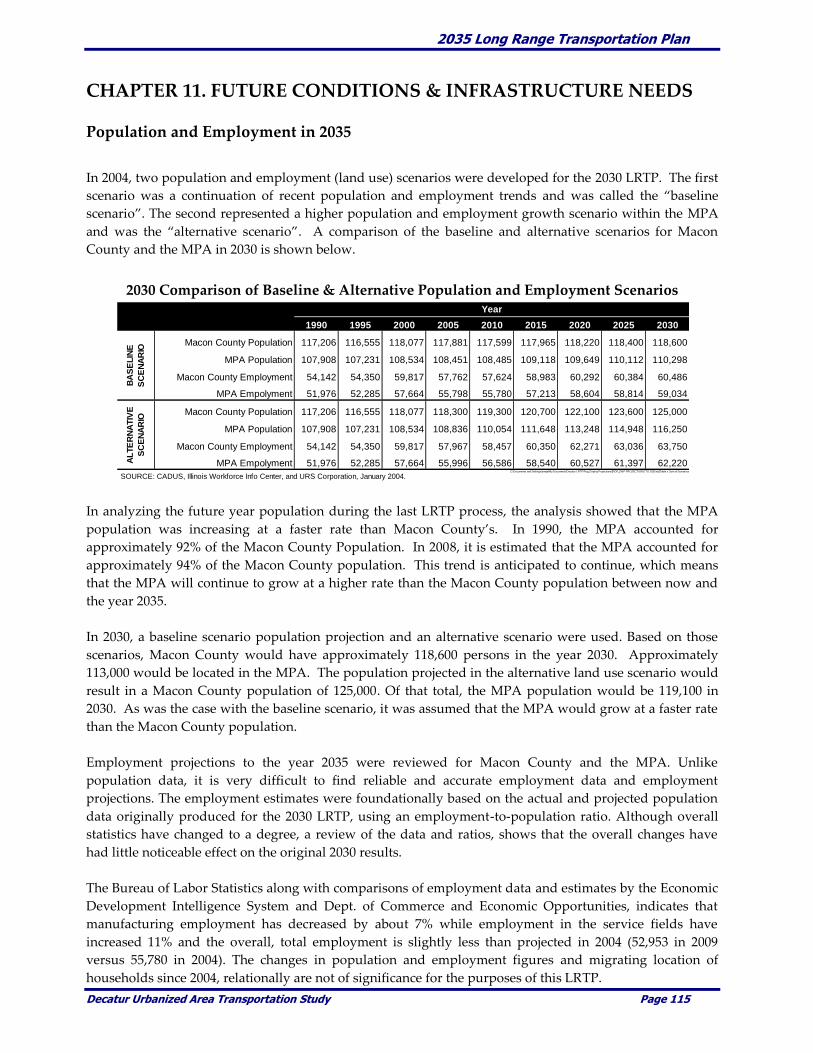
2035 Long Range Transportation Plan
Decatur Urbanized Area Transportation Study Page 115
CHAPTER 11. FUTURE CONDITIONS & INFRASTRUCTURE NEEDS
Population and Employment in 2035
In 2004, two population and employment (land use) scenarios were developed for the 2030 LRTP. The first
scenario was a continuation of recent population and employment trends and was called the “baseline
scenario”. The second represented a higher population and employment growth scenario within the MPA
and was the “alternative scenario”. A comparison of the baseline and alternative scenarios for Macon
County and the MPA in 2030 is shown below.
2030 Comparison of Baseline & Alternative Population and Employment Scenarios
In analyzing the future year population during the last LRTP process, the analysis showed that the MPA
population was increasing at a faster rate than Macon County’s. In 1990, the MPA accounted for
approximately 92% of the Macon County Population. In 2008, it is estimated that the MPA accounted for
approximately 94% of the Macon County population. This trend is anticipated to continue, which means
that the MPA will continue to grow at a higher rate than the Macon County population between now and
the year 2035.
In 2030, a baseline scenario population projection and an alternative scenario were used. Based on those
scenarios, Macon County would have approximately 118,600 persons in the year 2030. Approximately
113,000 would be located in the MPA. The population projected in the alternative land use scenario would
result in a Macon County population of 125,000. Of that total, the MPA population would be 119,100 in
2030. As was the case with the baseline scenario, it was assumed that the MPA would grow at a faster rate
than the Macon County population.
Employment projections to the year 2035 were reviewed for Macon County and the MPA. Unlike
population data, it is very difficult to find reliable and accurate employment data and employment
projections. The employment estimates were foundationally based on the actual and projected population
data originally produced for the 2030 LRTP, using an employment-to-population ratio. Although overall
statistics have changed to a degree, a review of the data and ratios, shows that the overall changes have
had little noticeable effect on the original 2030 results.
The Bureau of Labor Statistics along with comparisons of employment data and estimates by the Economic
Development Intelligence System and Dept. of Commerce and Economic Opportunities, indicates that
manufacturing employment has decreased by about 7% while employment in the service fields have
increased 11% and the overall, total employment is slightly less than projected in 2004 (52,953 in 2009
versus 55,780 in 2004). The changes in population and employment figures and migrating location of
households since 2004, relationally are not of significance for the purposes of this LRTP.
1990 1995 2000 2005 2010 2015 2020 2025 2030
Macon County Population 117,206 116,555 118,077 117,881 117,599 117,965 118,220 118,400 118,600
MPA Population 107,908 107,231 108,534 108,451 108,485 109,118 109,649 110,112 110,298
Macon County Employment 54,142 54,350 59,817 57,762 57,624 58,983 60,292 60,384 60,486
MPA Empolyment 51,976 52,285 57,664 55,798 55,780 57,213 58,604 58,814 59,034
Macon County Population 117,206 116,555 118,077 118,300 119,300 120,700 122,100 123,600 125,000
MPA Population 107,908 107,231 108,534 108,836 110,054 111,648 113,248 114,948 116,250
Macon County Employment 54,142 54,350 59,817 57,967 58,457 60,350 62,271 63,036 63,750
MPA Empolyment 51,976 52,285 57,664 55,996 56,586 58,540 60,527 61,397 62,220
SOURCE: CADUS, Illinois Workforce Info Center, and URS Corporation, January 2004.C:\Documents and Settings\jmeye\My Documents\Decatur LRTP\Pop_Employ Projections\[POP_EMP PROJECTIONS TO 2030.xls]Table x. Sum of Scenarios
BA
SE
LIN
E
SC
EN
AR
IO
AL
TE
RN
ATIV
E
SC
EN
AR
IO
Year

2035 Long Range Transportation Plan
Decatur Urbanized Area Transportation Study Page 116
The previously estimated 96% of the Macon County employment fell within the MPA remains valid. As
with population estimates, the assumption that with each five-year interval that the MPA-to-County ratio
increased by a small amount (0.2 in the 2030 LRTP). Similar to the population projections, this slight
increase in the ratio assumes a higher percentage of the overall County employment is within the MPA.
As noted in Chapter 1’s reference to the recently adopted Macon County – Decatur Comprehensive Plan and in
anticipation of a new transportation authorization bill, this LRTP update recognizes the critical importance
of community wide and interdisciplinary planning. It recognizes that many factors influence transportation
planning and improvement projects. This LRTP is intended to focus decision making not on transportation
issues alone, but also in relation to existing and planned land use, housing, education, public
infrastructure, environment and natural resources and economic development. Transportation planning
should be cognizant of other plans and visions. Transportation planning can also be used to guide decision
making.
This chapter summarizes the year 2035 conditions and identifies future year issues within the MPA. The
analysis addresses respective transportation modes to identify potential deficiencies or weaknesses related
to an individual mode, or to the overall transportation system. This section encourages the integration and
development of projects which help in reducing congestion, increases safety, enhances security and strives
to increase efficiencies in operating and maintaining the transportation system, reduces conflicts between
transportation modes and takes environmental issues into consideration. The concerns are identified and
potential improvements are presented for projects and areas within the MPA in order to assist in creating a
more diverse and efficient transportation system that is better able to respond to future travel and
transport demands in a cost effective and efficient manner.
Also, as noted in the Comprehensive Plan Macon County’s population growth over the next 25 years will
be very modest overall. Over the last 18 years, the County’s housing stock has been increasing, but the
population has been decreasing. The major loss of population has occurred in Decatur. Growth has been
taking place in Forsyth, Mt. Zion and the unincorporated County within the urban fringe.
As a result of this decentralization, travel to work times have been increasing. Over time, if this trend
continues and adequate planning is not undertaken, noticeable increases in ADT and congestion may result
in the reduction in the area’s overall quality of life.
This LRTP takes a slightly different and conservative approach to population figures over the next 25 and
does not directly use either the baseline or alternative scenarios. It is anticipated that through the 2010
Census, Macon County’s population will continue its decline. However, by 2015, the population will have
begun to increase. Once population begins to rise, it is assumed that population in the MPA will increase at
a faster rate than the rest of Macon County. The projected population figures are shown in the following
chart.
YEAR 2000 2005 2010 2015 2020 2025 2030 2035
Population 114,906 112,450 111,957 112,207 113,797 115,836 116,693 118,360
Source: IL DCEO, URS, Carmiros & DUATS, September, 2009
The anticipated short term population declines, coupled with the existing pressures on government
finances, make it extremely critical that transportation infrastructure and public facility investments be
made very carefully, wisely and cooperatively.

2035 Long Range Transportation Plan
Decatur Urbanized Area Transportation Study Page 117
Potential Transportation Improvements
The year 2035 population and employment projections for the MPA are presented simply to attempt to
validate future year transportation improvements. Population and employment figures and indicators
have not changed to a degree that would alter the variables used to project future year traffic levels in 2004.
In some respects, capacity, congestion, safety, etc., issues were diminished due to factors such as the
current recession, high fuel prices in 2008 and 2009 and the recent unemployment rates. These events kept
the ADT from increasing and on a few corridors the ADT had decreased between 2004 and 2009 counts.
Potential transportation improvements were identified and approved by the DUATS Technical and Policy
Committees on August 19, 2009. The following sections summarize the potential transportation
improvements being considered over the next twenty-five years within the MPA.
Three transportation improvement categories (committed, planned, and future projects) were identified as
part of this LRTP. The categories provide a procedural process that is used to program and coordinate
projects with the available funding based on the selection criteria. The transportation improvement
categories are defined as:
Committed Projects – For the purpose of this LRTP, committed projects are transportation
improvements that are planned in a given fiscal year, are programmed in the current TIP, are
fiscally constrained and are likely to be constructed by 2013.
Planned Projects – For the purpose of this LRTP, planned projects are transportation
improvements that are planned to be in place in 2014 or 2015. These projects may have a portion
of their funding source(s) identified. Since they have less than 100% of the construction cost
identified they not fiscally constrained and are considered “Illustrative.”
Future Projects – For the purpose of the LRTP, future projects are defined as potential
transportation projects that may be constructed from 2015 to 2035 or beyond. They have no
funding source(s) identified and are also included as “Illustrative.”
The committed and future transportation improvement projects chosen on August 19, 2009 are
summarized on Page 118 - 133. The location of these projects is displayed on the map found on Page 134.
The following paragraphs explain the project estimates and the rationale for them.
The project costs shown in FY 2010 – 2013 were calculated based on the Year of Expenditure. Typically this
involved including an “inflation factor” of 5% per year. With the fluctuations of material costs, availability
of labor and other factors inherent in the construction planning process, those costs shown may or may not
prove to be be accurate in the year the project is commenced.
The project estimates listed as “Planned” and “Future” were calculated using the best available
information at the time this LRTP was written. Since no construction year is assigned to any of these
projects and since many, if not most, are so out into the future, any cost calculations would be of very
limited value.
The Maintenance and Operations cost estimates for revenue on Page 134 include a 3% “inflationary factor.”

2035 Long Range Transportation Plan
Decatur Urbanized Area Transportation Study Page 118
Roadway Improvement Projects
IDOT IMPROVEMENTS – Committed, Planned and Future
IDOT Committed for FY 2010
Repaving 1.1 miles of U.S. Route 36, Railroad to IL Route 105
State STP-U $ 960,000
State Matching Funds $ 240,000
Total Project Cost $1,200,000
IDOT Committed for FY 2011
Bridge Rehabilitation U.S. 51 over I-72
Federal BRRP $3,200,000
State Matching Funds 800,000
Total Project Cost $4,000,000
Patching, Repair and Resurfacing 4.8 miles of
U.S. Route 36 from Bus. Route 51 west to Route 51
Federal NHS $4,816,000
State Matching Funds $1,204,000
Total Project Cost $6,020,000
Resurfacing 3.02 miles IL Route 48, from Bus. Route 51
To IL 105 and IL Route 48 to US 51.
Federal STP-U State $1,808,000
State Matching Funds $ 452,000
Total Project Cost $2,260,000
IDOT Committed for FY 2012
Bridge Rehabilitation, U.S. Route 51 at NSRR
Federal STP-U $2,320,000
State Matching Funds $ 580,000
Total Project Cost $2,900,000

2035 Long Range Transportation Plan
Decatur Urbanized Area Transportation Study Page 119
IDOT PLANNED PROJECTS
Bridge Replacement, Route 51 (NB & SB)
over Sangamon River, 1 mile south of Harristown
Federal STP-Rural Funds $19,720,000
State Matching Funds $ 4,930,000
Total Project Cost $24,650,000
IDOT FUTURE PROJECTS
Patching and Repaving 5.12 miles of I-72,
1.5 miles east of IL Route 48, to 4.4 miles
West of Piatt County line.
Interstate Maintenance $7,920,000
State Matching Funds $ 880,000
Total Project Cost $8,800,000
Culvert Repairs/Replacement and resurfacing
13.35 miles of IL Route 48 from IL Route 121 to I-72
Federal STP-R Funds $3,840,000
State Matching Funds $ 960,000
Total Project Cost $4,800,000
Resurfacing 1.97 miles of IL Route 48,
Marietta Street to South Side Drive
Federal STP-U Funds $1,136,000
State Matching Funds $ 284,000
Total Project Cost $1,420,000
Resurfacing 2.84 miles of IL Route 121 from
Damon Avenue to Lakeshore Drive
Federal STP-U Funds $2,120,000
State Matching Funds $ 530,000
Total Project Cost $2,650,000
Resurfacing 3.19 miles of Main Street from
County Highway 21 to Wyckles Road
State Funds $1,120,000
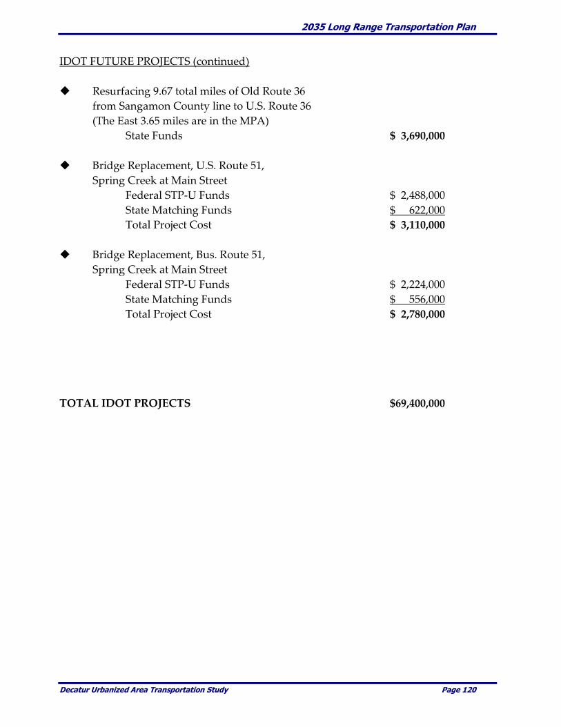
2035 Long Range Transportation Plan
Decatur Urbanized Area Transportation Study Page 120
IDOT FUTURE PROJECTS (continued)
Resurfacing 9.67 total miles of Old Route 36
from Sangamon County line to U.S. Route 36
(The East 3.65 miles are in the MPA)
State Funds $ 3,690,000
Bridge Replacement, U.S. Route 51,
Spring Creek at Main Street
Federal STP-U Funds $ 2,488,000
State Matching Funds $ 622,000
Total Project Cost $ 3,110,000
Bridge Replacement, Bus. Route 51,
Spring Creek at Main Street
Federal STP-U Funds $ 2,224,000
State Matching Funds $ 556,000
Total Project Cost $ 2,780,000
TOTAL IDOT PROJECTS $69,400,000
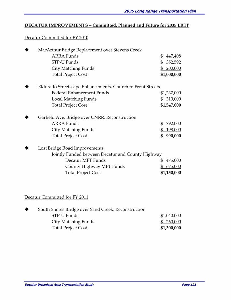
2035 Long Range Transportation Plan
Decatur Urbanized Area Transportation Study Page 121
DECATUR IMPROVEMENTS – Committed, Planned and Future for 2035 LRTP
Decatur Committed for FY 2010
MacArthur Bridge Replacement over Stevens Creek
ARRA Funds $ 447,408
STP-U Funds $ 352,592
City Matching Funds $ 200,000
Total Project Cost $1,000,000
Eldorado Streetscape Enhancements, Church to Front Streets
Federal Enhancement Funds $1,237,000
Local Matching Funds $ 310,000
Total Project Cost $1,547,000
Garfield Ave. Bridge over CNRR, Reconstruction
ARRA Funds $ 792,000
City Matching Funds $ 198,000
Total Project Cost $ 990,000
Lost Bridge Road Improvements
Jointly Funded between Decatur and County Highway
Decatur MFT Funds $ 475,000
County Highway MFT Funds $ 675,000
Total Project Cost $1,150,000
Decatur Committed for FY 2011
South Shores Bridge over Sand Creek, Reconstruction
STP-U Funds $1,040,000
City Matching Funds $ 260,000
Total Project Cost $1,300,000

2035 Long Range Transportation Plan
Decatur Urbanized Area Transportation Study Page 122
DECATUR FUTURE PROJECTS
Brush College Road Improvements $11,400,000 – $13,600,000
Phase 1: Study to construct an overpass structure
over Norfolk Southern Railroad or replacing the
existing narrow underpass with a new bridge
to accommodate more lanes on Brush College Road.
Phase 2: Preparation of designs, acquiring
rights-of-way and relocating utilities.
Phase 3: Construction of the improvements.
Potential Funding Sources: STP-U, Capital Bill, ICC, Grade Crossing Protection Fund,
General Funds, Cost Sharing with Railroads.
Downtown Truck Route Relocation
Funding Source(s) Unknown
Truck Route Improvements $2,360,000
Jurisdictional Transfer $2,332,000
Total Project Cost $4.692,000
Would relocate the Downtown portion of the existing truck route from Main and
Franklin Streets to Martin Luther King (MLK) Drive using Wood Street as the connection.
Improvements are proposed to the MLK and Wood Street intersection to make the truck
route safer and more efficient route for large trucks. A left turn ramp is proposed that
will avoid an at-grade railroad crossing.
Potential Funding Sources: STP-U, Capital Bill, ICC, Grade Crossing Protection Fund,
General Funds.
Center Street Bridge over Stevens Creek
Funding Source(s) Unknown $1,150,000
27th Street Reconstruction- Fairies Parkway to Route 48
Funding Source(s) Unknown $6,900,000
Jasper Street Reconstruction, Eldorado to Pershing Road
Funding Source(s) Unknown $1,700,000

2035 Long Range Transportation Plan
Decatur Urbanized Area Transportation Study Page 123
DECATUR FUTURE PROJECTS (continued)
Jasper Street Underpass Reconstruction
Funding Source(s) Unknown
Utility Relocation $ 1,300,000
Underpass Reconstruction $ 8,000,000 - $ 13,000,000
Ash Avenue Extension, MLK Drive to Route 48
Funding Source(s) Unknown
Engineering $ 2,000,000 - $ 2,400,000
Right of Way & Construction $16,000,000- $ 20,000,000
TOTAL DECATUR PROJECTS $74,500,000
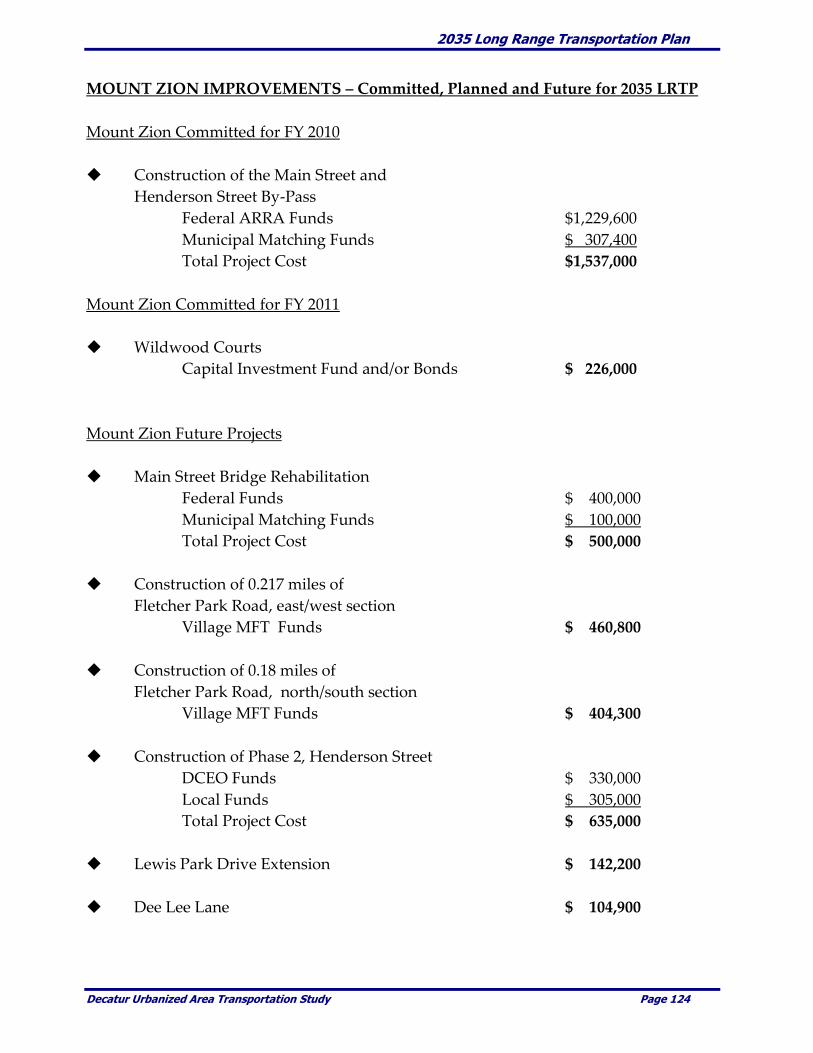
2035 Long Range Transportation Plan
Decatur Urbanized Area Transportation Study Page 124
MOUNT ZION IMPROVEMENTS – Committed, Planned and Future for 2035 LRTP
Mount Zion Committed for FY 2010
Construction of the Main Street and
Henderson Street By-Pass
Federal ARRA Funds $1,229,600
Municipal Matching Funds $ 307,400
Total Project Cost $1,537,000
Mount Zion Committed for FY 2011
Wildwood Courts
Capital Investment Fund and/or Bonds $ 226,000
Mount Zion Future Projects
Main Street Bridge Rehabilitation
Federal Funds $ 400,000
Municipal Matching Funds $ 100,000
Total Project Cost $ 500,000
Construction of 0.217 miles of
Fletcher Park Road, east/west section
Village MFT Funds $ 460,800
Construction of 0.18 miles of
Fletcher Park Road, north/south section
Village MFT Funds $ 404,300
Construction of Phase 2, Henderson Street
DCEO Funds $ 330,000
Local Funds $ 305,000
Total Project Cost $ 635,000
Lewis Park Drive Extension $ 142,200
Dee Lee Lane $ 104,900
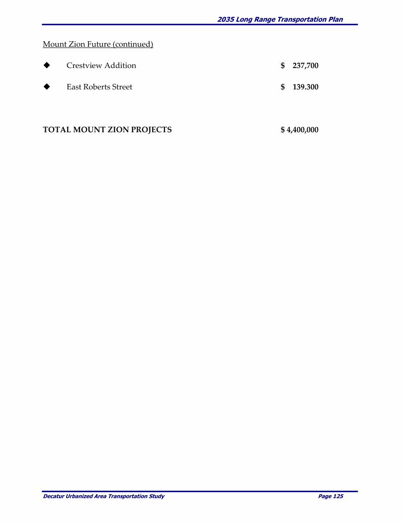
2035 Long Range Transportation Plan
Decatur Urbanized Area Transportation Study Page 125
Mount Zion Future (continued)
Crestview Addition $ 237,700
East Roberts Street $ 139.300
TOTAL MOUNT ZION PROJECTS $ 4,400,000

2035 Long Range Transportation Plan
Decatur Urbanized Area Transportation Study Page 126
FORSYTH IMPROVEMENTS – Committed, Planned and Future for 2035 LRTP
Forsyth Committed Projects in FY 2010
West Hickory Point Drive Reconstruction,
from Rout 51, to south on Hickory Point Road
Federal STP-U Funds $ 647,800
Local Matching Funds $ 162,000
Total Project Costs $ 809,800
Improvements on Illiniwick Road (CH #20)
Local Funds $ 90,000
Forsyth Committed Projects in FY 2011
Smith Street Reconstruction to CH #20 (Phase IV)
Local Funds $ 650,000
Magnolia and U.S. Route 51 Intersection Study
Local Funds $ 50,000
Highland Avenue Overlay
Local Funds $ 90,000
Forsyth Estates Overlay
Local Funds $ 125,000
Lucile Avenue Paving
Local Funds $ 90,000
Forsyth Committed Projects in FY 2013
Christopher Drive Drainage Improvements
Local Funds $ 115,000
Moon Street Reconstruction
Local Funds $ 270,000
West Cox Street (Possible in FY 2013)
Local Funds $ 250,000
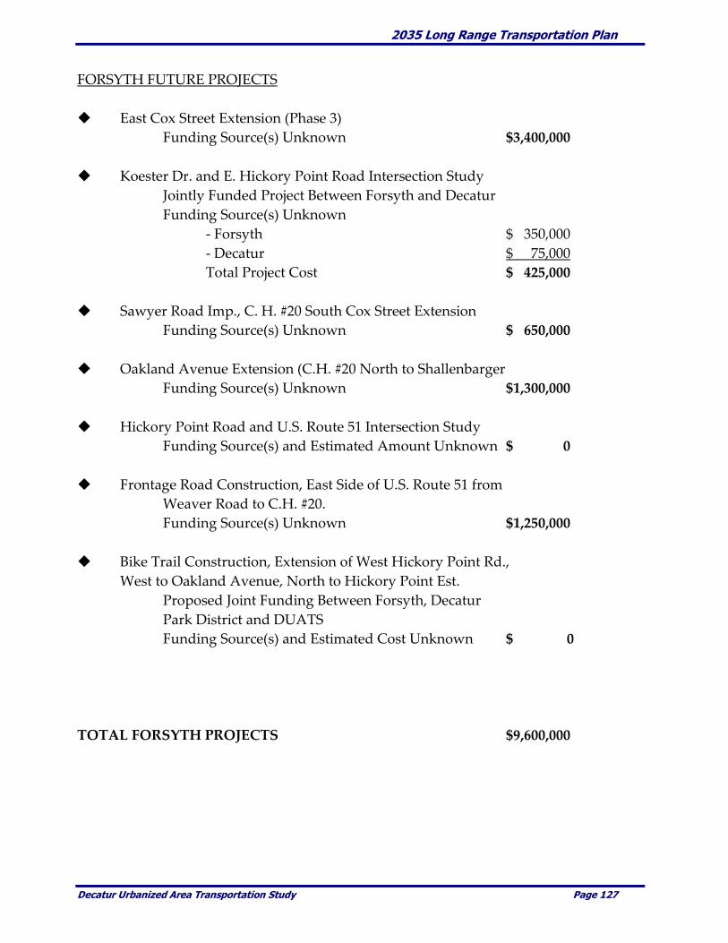
2035 Long Range Transportation Plan
Decatur Urbanized Area Transportation Study Page 127
FORSYTH FUTURE PROJECTS
East Cox Street Extension (Phase 3)
Funding Source(s) Unknown $3,400,000
Koester Dr. and E. Hickory Point Road Intersection Study
Jointly Funded Project Between Forsyth and Decatur
Funding Source(s) Unknown
- Forsyth $ 350,000
- Decatur $ 75,000
Total Project Cost $ 425,000
Sawyer Road Imp., C. H. #20 South Cox Street Extension
Funding Source(s) Unknown $ 650,000
Oakland Avenue Extension (C.H. #20 North to Shallenbarger
Funding Source(s) Unknown $1,300,000
Hickory Point Road and U.S. Route 51 Intersection Study
Funding Source(s) and Estimated Amount Unknown $ 0
Frontage Road Construction, East Side of U.S. Route 51 from
Weaver Road to C.H. #20.
Funding Source(s) Unknown $1,250,000
Bike Trail Construction, Extension of West Hickory Point Rd.,
West to Oakland Avenue, North to Hickory Point Est.
Proposed Joint Funding Between Forsyth, Decatur
Park District and DUATS
Funding Source(s) and Estimated Cost Unknown $ 0
TOTAL FORSYTH PROJECTS $9,600,000
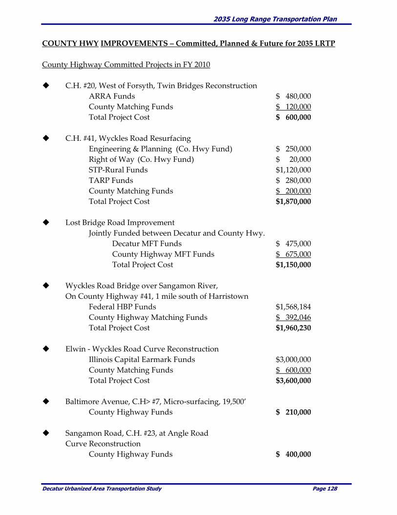
2035 Long Range Transportation Plan
Decatur Urbanized Area Transportation Study Page 128
COUNTY HWY IMPROVEMENTS – Committed, Planned & Future for 2035 LRTP
County Highway Committed Projects in FY 2010
C.H. #20, West of Forsyth, Twin Bridges Reconstruction
ARRA Funds $ 480,000
County Matching Funds $ 120,000
Total Project Cost $ 600,000
C.H. #41, Wyckles Road Resurfacing
Engineering & Planning (Co. Hwy Fund) $ 250,000
Right of Way (Co. Hwy Fund) $ 20,000
STP-Rural Funds $1,120,000
TARP Funds $ 280,000
County Matching Funds $ 200,000
Total Project Cost $1,870,000
Lost Bridge Road Improvement
Jointly Funded between Decatur and County Hwy.
Decatur MFT Funds $ 475,000
County Highway MFT Funds $ 675,000
Total Project Cost $1,150,000
Wyckles Road Bridge over Sangamon River,
On County Highway #41, 1 mile south of Harristown
Federal HBP Funds $1,568,184
County Highway Matching Funds $ 392,046
Total Project Cost $1,960,230
Elwin - Wyckles Road Curve Reconstruction
Illinois Capital Earmark Funds $3,000,000
County Matching Funds $ 600,000
Total Project Cost $3,600,000
Baltimore Avenue, C.H> #7, Micro-surfacing, 19,500’
County Highway Funds $ 210,000
Sangamon Road, C.H. #23, at Angle Road
Curve Reconstruction
County Highway Funds $ 400,000
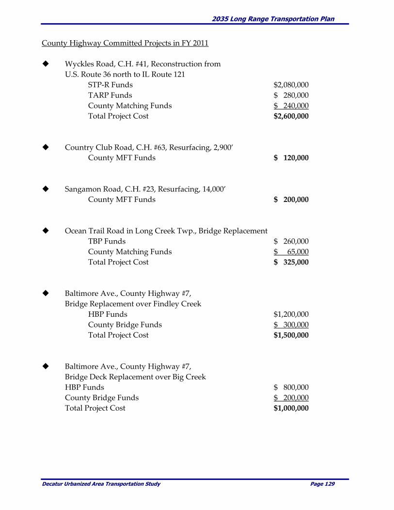
2035 Long Range Transportation Plan
Decatur Urbanized Area Transportation Study Page 129
County Highway Committed Projects in FY 2011
Wyckles Road, C.H. #41, Reconstruction from
U.S. Route 36 north to IL Route 121
STP-R Funds $2,080,000
TARP Funds $ 280,000
County Matching Funds $ 240,000
Total Project Cost $2,600,000
Country Club Road, C.H. #63, Resurfacing, 2,900’
County MFT Funds $ 120,000
Sangamon Road, C.H. #23, Resurfacing, 14,000’
County MFT Funds $ 200,000
Ocean Trail Road in Long Creek Twp., Bridge Replacement
TBP Funds $ 260,000
County Matching Funds $ 65,000
Total Project Cost $ 325,000
Baltimore Ave., County Highway #7,
Bridge Replacement over Findley Creek
HBP Funds $1,200,000
County Bridge Funds $ 300,000
Total Project Cost $1,500,000
Baltimore Ave., County Highway #7,
Bridge Deck Replacement over Big Creek
HBP Funds $ 800,000
County Bridge Funds $ 200,000
Total Project Cost $1,000,000
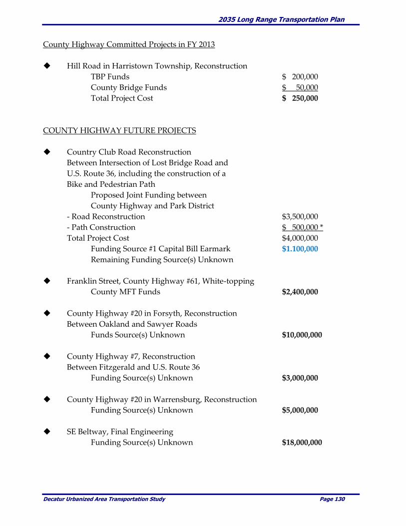
2035 Long Range Transportation Plan
Decatur Urbanized Area Transportation Study Page 130
County Highway Committed Projects in FY 2013
Hill Road in Harristown Township, Reconstruction
TBP Funds $ 200,000
County Bridge Funds $ 50,000
Total Project Cost $ 250,000
COUNTY HIGHWAY FUTURE PROJECTS
Country Club Road Reconstruction
Between Intersection of Lost Bridge Road and
U.S. Route 36, including the construction of a
Bike and Pedestrian Path
Proposed Joint Funding between
County Highway and Park District
- Road Reconstruction $3,500,000
- Path Construction $ 500,000 *
Total Project Cost $4,000,000
Funding Source #1 Capital Bill Earmark $1.100,000
Remaining Funding Source(s) Unknown
Franklin Street, County Highway #61, White-topping
County MFT Funds $2,400,000
County Highway #20 in Forsyth, Reconstruction
Between Oakland and Sawyer Roads
Funds Source(s) Unknown $10,000,000
County Highway #7, Reconstruction
Between Fitzgerald and U.S. Route 36
Funding Source(s) Unknown $3,000,000
County Highway #20 in Warrensburg, Reconstruction
Funding Source(s) Unknown $5,000,000
SE Beltway, Final Engineering
Funding Source(s) Unknown $18,000,000
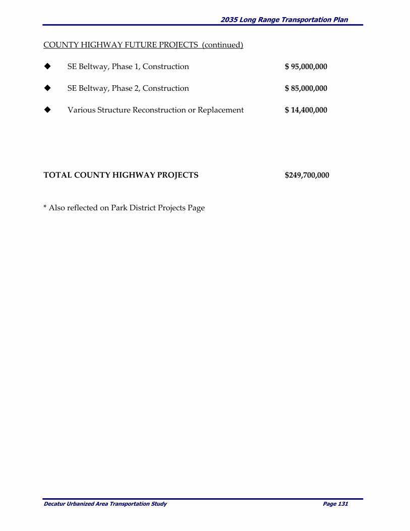
2035 Long Range Transportation Plan
Decatur Urbanized Area Transportation Study Page 131
COUNTY HIGHWAY FUTURE PROJECTS (continued)
SE Beltway, Phase 1, Construction $ 95,000,000
SE Beltway, Phase 2, Construction $ 85,000,000
Various Structure Reconstruction or Replacement $ 14,400,000
TOTAL COUNTY HIGHWAY PROJECTS $249,700,000
* Also reflected on Park District Projects Page

2035 Long Range Transportation Plan
Decatur Urbanized Area Transportation Study Page 132
DECATUR PARK DISTRICT PROJECTS
Park District Committed Projects in FY 2010
Engineering Work for the West End
Bridge Project in Fairview Park
- Park District Funds $ 50,000
Stevens Creek Bike Trail from
Fairview Park to Greendell Park
- Federal Enhancement Funds $1,795,930
- Park District Matching Funds $1,904,070
- Total Project Cost $3,700,000
PARK DISTRICT FUTURE PROJECTS
West End Bridge, Fairview Road, Fairview Park
- Funding Source(s) Unknown $ 850,000
Bike Trail Project in conjunction with
Country Club Road Reconstruction Project
- Funding Source(s) Unknown $ 500,000
West End Road Reconstruction, Fairview Park
- Funding Source(s) Unknown $ 80,000
Twin Bridge Road Project
Reconstructing and widening from U.S. Route 36,
north to the Decatur Airport (1), OR from north
end of Twin Bridge Road west to Airport Road (2)
Funding Source(s) Unknown
- Total Project Cost (1) $2,500,000
- Total Project Cost (2) $1,250,000
Fairies Park Road Reconstruction and Repaving
- Funding Source(s) Unknown $ 325,000
TOTAL PARK DISTRICT PROJECTS $7,500,000

2035 Long Range Transportation Plan
Decatur Urbanized Area Transportation Study Page 133
MACON COUNTY CONSERVATION DISTRICT (MCCD) PROJECTS
MCCD Projects Committed for FY 2010
Rock Springs Trail Improvements
Replacement of 2 foot bridges
- National Recreational Trails Funding $ 31,600
- MCCD Matching Funds $ 7,900
- Total Project Cost $ 39,600
MCCD FUTURE PROJECTS
Ft. Daniels Trail Improvement
Replacement of 3 trail structures
- Funding Source(s) Unknown $ 88,000
TOTAL MCCD PROJECTS $ 127,600

2035 Long Range Transportation Plan
Decatur Urbanized Area Transportation Study Page 134
ANTICIPATED GENERAL MAINTENANCE & OPERATIONS
(The following figures are rounded. The 25 year projections assume a constant 3%
increase in the base amount, cumulative over the planning period of 2010 through 2035)
Entity FY 2010 2010-2035
IL Dept of Transportation w/in MPA $ 175,000 $ 6,400,000
County Highway $ 720,000 $ 27,700,000
Decatur $3,000,000 $115,000,000
Forsyth $ 30,000 $ 1,200,000
Harristown $ 35,000 $ 1,350,000
Long Creek $ 90,000 $ 3,500,000
Mount Zion $ 50,000 $ 2,000,000
Oreana $ 35,000 $ 1,400,000
Warrensburg $ 40,000 $ 1,500,000
Township Road Districts w/in MPA $ 600,000 $ 23,000,000
TOTAL MAINTENANCE & OPERATIONS $4,775,000 $183,000,000

2035 Long Range Transportation Plan
Decatur Urbanized Area Transportation Study Page 135
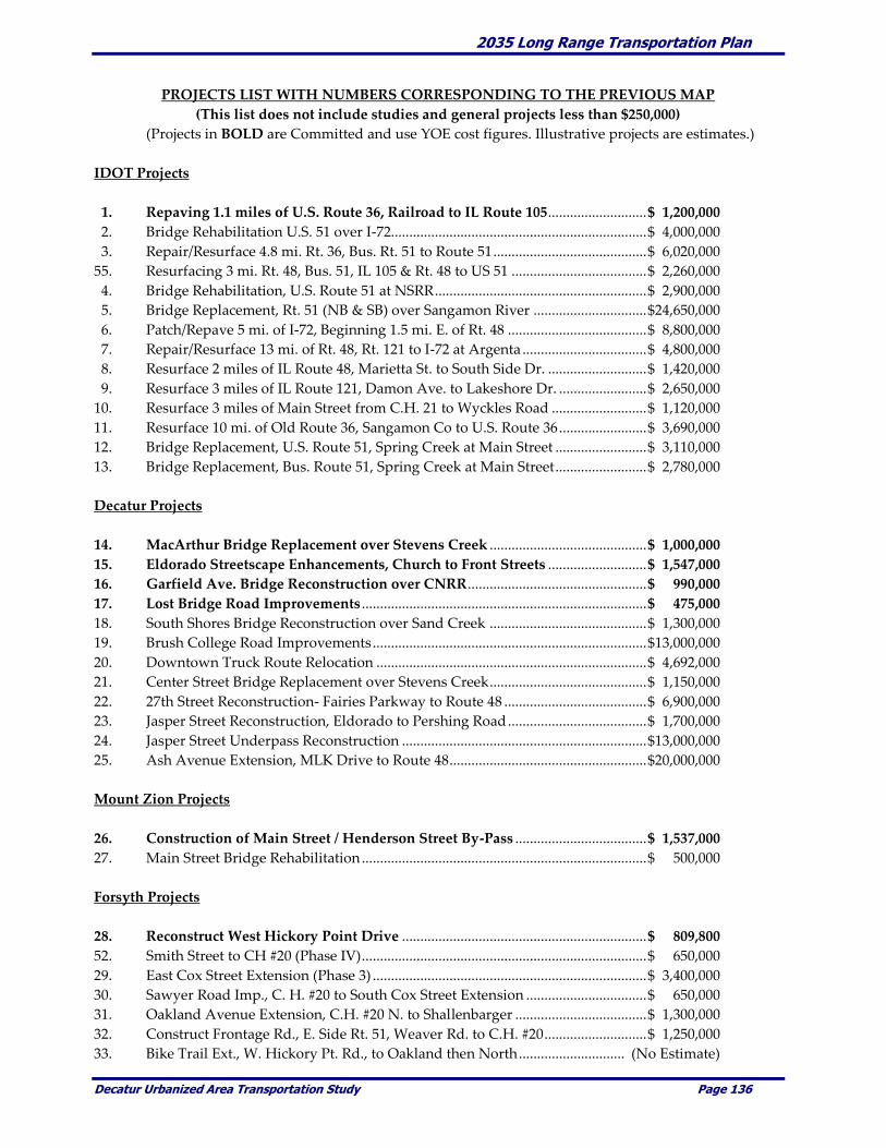
2035 Long Range Transportation Plan
Decatur Urbanized Area Transportation Study Page 136
PROJECTS LIST WITH NUMBERS CORRESPONDING TO THE PREVIOUS MAP
(This list does not include studies and general projects less than $250,000)
(Projects in BOLD are Committed and use YOE cost figures. Illustrative projects are estimates.)
IDOT Projects
1. Repaving 1.1 miles of U.S. Route 36, Railroad to IL Route 105........................... $ 1,200,000
2. Bridge Rehabilitation U.S. 51 over I-72...................................................................... $ 4,000,000
3. Repair/Resurface 4.8 mi. Rt. 36, Bus. Rt. 51 to Route 51 .......................................... $ 6,020,000
55. Resurfacing 3 mi. Rt. 48, Bus. 51, IL 105 & Rt. 48 to US 51 ..................................... $ 2,260,000
4. Bridge Rehabilitation, U.S. Route 51 at NSRR .......................................................... $ 2,900,000
5. Bridge Replacement, Rt. 51 (NB & SB) over Sangamon River ............................... $24,650,000
6. Patch/Repave 5 mi. of I-72, Beginning 1.5 mi. E. of Rt. 48 ...................................... $ 8,800,000
7. Repair/Resurface 13 mi. of Rt. 48, Rt. 121 to I-72 at Argenta .................................. $ 4,800,000
8. Resurface 2 miles of IL Route 48, Marietta St. to South Side Dr. ........................... $ 1,420,000
9. Resurface 3 miles of IL Route 121, Damon Ave. to Lakeshore Dr. ........................ $ 2,650,000
10. Resurface 3 miles of Main Street from C.H. 21 to Wyckles Road .......................... $ 1,120,000
11. Resurface 10 mi. of Old Route 36, Sangamon Co to U.S. Route 36 ........................ $ 3,690,000
12. Bridge Replacement, U.S. Route 51, Spring Creek at Main Street ......................... $ 3,110,000
13. Bridge Replacement, Bus. Route 51, Spring Creek at Main Street ......................... $ 2,780,000
Decatur Projects
14. MacArthur Bridge Replacement over Stevens Creek ........................................... $ 1,000,000
15. Eldorado Streetscape Enhancements, Church to Front Streets ........................... $ 1,547,000
16. Garfield Ave. Bridge Reconstruction over CNRR ................................................. $ 990,000
17. Lost Bridge Road Improvements .............................................................................. $ 475,000
18. South Shores Bridge Reconstruction over Sand Creek ........................................... $ 1,300,000
19. Brush College Road Improvements ........................................................................... $13,000,000
20. Downtown Truck Route Relocation .......................................................................... $ 4,692,000
21. Center Street Bridge Replacement over Stevens Creek ........................................... $ 1,150,000
22. 27th Street Reconstruction- Fairies Parkway to Route 48 ....................................... $ 6,900,000
23. Jasper Street Reconstruction, Eldorado to Pershing Road ...................................... $ 1,700,000
24. Jasper Street Underpass Reconstruction ................................................................... $13,000,000
25. Ash Avenue Extension, MLK Drive to Route 48 ...................................................... $20,000,000
Mount Zion Projects
26. Construction of Main Street / Henderson Street By-Pass .................................... $ 1,537,000
27. Main Street Bridge Rehabilitation .............................................................................. $ 500,000
Forsyth Projects
28. Reconstruct West Hickory Point Drive ................................................................... $ 809,800
52. Smith Street to CH #20 (Phase IV) .............................................................................. $ 650,000
29. East Cox Street Extension (Phase 3) ........................................................................... $ 3,400,000
30. Sawyer Road Imp., C. H. #20 to South Cox Street Extension ................................. $ 650,000
31. Oakland Avenue Extension, C.H. #20 N. to Shallenbarger .................................... $ 1,300,000
32. Construct Frontage Rd., E. Side Rt. 51, Weaver Rd. to C.H. #20 ............................ $ 1,250,000
33. Bike Trail Ext., W. Hickory Pt. Rd., to Oakland then North ............................. (No Estimate)

2035 Long Range Transportation Plan
Decatur Urbanized Area Transportation Study Page 137
County Highway Projects
34. Twin Bridges Reconstruction, C.H. #20, West of Forsyth ..................................... $ 600,000
53. Resurface C.H. #41, Wyckles Road ............................................................................ $ 1,870,000
17. Lost Bridge Road Improvements ............................................................................... $ 1,150,000
35. Wyckles Road Bridge over Sangamon River ........................................................... $ 1,960,230
36. Reconstruct Elwin - Wyckles Road Curve ................................................................. $ 3,600,000
37. Reconstruct Curve Sangamon Rd., C.H. #23, at Angle Rd. ...................................... $ 400,000
38. Reconstruct Wyckles Road, C.H. #41, Rt. 36 to Rt. 121............................................. $ 2,600,000
39. Bridge Replacement on Ocean Trail Rd., Long Creek Twp. ..................................... $ 325,000
41. Bridge Replacement over Findley Creek, Baltimore Ave., C.H. #7 ........................ $ 1,500,000
42. Deck Replacement over Big Creek Baltimore Ave., C.H. #7.................................... $ 1,000,000
42. Country Club Road Reconstruction & Bike .............................................................. $ 4,000,000
54. Franklin Street, C.H. #61, White-topping .................................................................. $ 2,400,000
43. Reconstruct C.H. #20 in Forsyth, Oakland Ave. to Sawyer Rd. ............................. $10,000,000
45. Reconstruct C.H. #7, Fitzgerald St. to Rt. 36 ............................................................. $ 3,000,000
44. Reconstruct C.H. #20 in Warrensburg ....................................................................... $ 5,000,000
46. Construct SE Beltway, Phase 1, Rt. 48/Brush College to Rt. 36 ............................. $ 95,000,000
47. Construct SE Beltway, Phase 2, Rt. 36 to Elwin....................................................... $ 85,000,000
Park District Projects
51. Stevens Creek Bike Trail (Phase 1), Fairview to Greendell Park ......................... $3,700,000
48. West End Bridge, Fairview Road, Fairview Park......................................................... $ 850,000
42. Bike Trail in conjunction with Country Club Rd. Reconstruction ............................. $ 500,000
50. Twin Bridge Road Project ............................................................................................ $ 2,000,000
49. Repair/Repave Fairies Park Road.................................................................................. $ 325,000

2035 Long Range Transportation Plan
Decatur Urbanized Area Transportation Study Page 138
Transit Operations
Within recent years, two comprehensive transit studies evaluating fixed-route and paratransit service
within the Decatur Urbanized Area have been completed. Based on these studies, the DPTS implemented
service changes including a restructuring of the fixed-route system. The DPTS constantly monitors service
performance and when appropriate will make modifications to better serve the needs of the community.
In addition the normal vehicle replacement plan DPTS has secured approval and $191,000 in funding for
the following 3 transportation related projects.
$143,000 will be invested to repair/remodel the bus barn, including updating the plumbing,
electrical, heating and air conditioning systems, remodeling the restrooms and offices, and
sealing and painting the exterior walls;
$18,000 will go toward repairing and sealcoating the asphalt parking areas and driving lanes
on the north side of the Transit Administration Building; and
$30,000 will be spent for the installation of a water recycling system in the bus washer to
reduce the amount of water used in washing buses.
The following table identifies the vehicle replacement schedule anticipated by the DPTS over the next
twenty-five years. Additional improvements (i.e., extended night service, modified or new routes, etc.) are
evaluated as the need arises with implementation tied very closely to available funding.
TRANSIT IMPROVEMENTS
Vehicle Estimated
Type Improvement Description Year
Buses 4 Replacement 35' Low Floor Buses 2010
7 Replacement 30' Low Floor Buses 2013
6 Replacement 30' Low Floor Buses 2017
5 Replacement 30' Low Floor Buses and
4 Replacement 35' Low Floor Buses 2023
7 Replacement 30' Low Floor Buses 2027
6 Replacement 30' Low Floor Buses 2031
Trolleys 2 Replacement Trolley Replica Coaches 2016
Wheelchair-Lift Vans 2 Replacement Light-Duty Lift Vans 2010
2 Replacement Light-Duty Lift Vans 2013
2 Replacement Light-Duty Lift Vans 2016
2 Replacement Light-Duty Lift Vans 2019
2 Replacement Light-Duty Lift Vans 2022
2 Replacement Light-Duty Lift Vans 2025
2 Replacement Light-Duty Lift Vans 2028
2 Replacement Light-Duty Lift Vans 2031
2 Replacement Light-Duty Lift Vans 2034 SOURCE: Decatur Public Transit System, August, 2009

2035 Long Range Transportation Plan
Decatur Urbanized Area Transportation Study Page 139
Bicycles
In 1999, DUATS adopted the Decatur Urbanized Area Comprehensive Bicycle Plan, 1996-2016. It and the
Metro Area Greenways Plan are being merged into one planning document. The newly updated and
merged Plan is intended to be used in assisting local governments and interested parties make decisions
and to place priorities on ways to enhance the bicycle as a mode of transportation in the MPA. It is also
intended to provide information on which trails and road segment should be sought first and in what
order.
Future enhancement projects for the MPA include expanding and connecting the trail system. This system
includes the Stevens Creek corridor and a trail around Lake Decatur that would connect to the Fairview
Park and Rock Springs trails. Forsyth and Mt. Zion continue to expand their bike and pedestrian trails as
opportunity and funding come available. These trails are intended to interconnect with other trail systems.
The principal priority project currently is Phase 1 of the Stevens Creek Bike Trail. Engineering, approvals
and right of way acquisition is complete. The project was put out for bid early in 2009, but bids came in
considerably over the engineering estimate. The project has been put on hold until final financing can be
secured. Phase 2 of the trail is presently being engineered. Trail facilities around Lake Decatur are also of
very high importance as the Lake is focused for recreational development in the near future.
Trail improvements have been complemented from the northwest corner of Spitler Woods State Park to
Baltimore, north to Harry Land Road and west to Southbrook Drive. Partial funding for this trail was
provided by the State of Illinois. As funding becomes available, the State will be encourage to participate
with local entities to further the construction of bike and pedestrian ways along with other alternative
modes of transportation.
The Village of Forsyth continues to expand its network of trails as the municipality grows. Recent additions
have included paths along new streets on the Village’s west side and connections on the north side.
Decatur recently dedicated a dedicated bike path along the newly reconstructed West Main Street. This
path runs parallel to Main Street and extends from the CBD to Millikin University. Another path in Decatur
includes an approximately one mile path along Lincoln Park Drive which was constructed by the Decatur
Park District.
The State of Illinois has a comprehensive trail plan. The MPA is not currently connected to the statewide
trail plan. However, as opportunities and financing become available, connecting trail corridors will
become a higher priority.
Rail Operations
Rail improvements within the MPA are principally the responsibility of the individual rail companies. In
the past, most of the improvements consisted of track and at-grade rail crossing maintenance. However, at
recent Technical and Policy Committee meetings the idea of creating an ad hoc group to study the rail
network and its interface with the surface transportation network has been discussed.
The scope of this issue would include improving rail movements, crossing improvements, freight
consolidation, transload/intermodal facilities, freight logistics improvements, possible rail crossing
closures, passenger rail accommodations and possibly brownfield cleanup and abandoned site
redevelopment, highway corridor improvements and other areas and issues yet to be determined.
Convening this discussion group would require the interest and participation of both the public and
2035 Long Range Transportation Plan
Decatur Urbanized Area Transportation Study Page 140
private sectors. The group would need to include representatives of the railroads, business, industry,
municipal, County and other local government representatives and other interested entities. This item will
be addressed and hopefully initiated in the first quarter of calendar year 2010.
Aviation
The Park District maintains an updated version of the Airport Layout Plan, which proposes improvements
which are planned to occur over the next 25 years. The improvements are intended to enhance the
capabilities of the facility as an engine for economic growth, provide efficient and cost effective passenger
and freight movement and enhance the quality of life of the community. The Decatur Park District
identified improvement projects to be included in the 2035 LRTP. These projects were identified in October
2009, for implementation on a schedule yet to be determined. Land acquisition is considered an on-going
process with no-time frame identified.
The improvements include a new entrance road connection, business/industrial park infrastructure,
lengthening the primary runway, new runway lighting, a second cargo apron and lengthening the
secondary runway.
Roadways and 2035 Projected Traffic Volumes
The travel demand forecasting model (TRANPLAN) used in 2004 to evaluate future year transportation
improvements during the development of the 2030 LRTP was not used in this LRTP update. It was
determined that conditions had not changed to the degree which would warrant the expense of modeling.
During the process of reviewing the 2030 LRTP population, ADT, employment and physical transportation
infrastructure were evaluated. It was determined that an additional modeling run would serve no useful
purpose given the demographics and physical infrastructure at present and as projected. There were no
significant changes in any of the variables affecting transportation planning. The proposed projects on
which the modeling and scenarios used in 2004 were based were significantly changed. All but a few High
Priority Projects in 2004 were deleted from this LRTP. If conditions warrant and variables change
significantly in coming years the use of modeling software may be necessary.
There are approximately six miles of roadway are identified as operating at-capacity while between about
20 miles were identified as approaching-capacity. The number of miles approaching-capacity is slightly
lower than observed in the year 2004. It is important to note that the majority, if not all, of the roadways
identified as approaching-capacity provide a high level of mobility. The classification of approaching-
capacity is intended to identify areas that could either reach capacity or exceed capacity if additional traffic
is generated by new or larger developments. These roadway segments are highlighted so they can be
monitored to ensure that these segments do not reach an over-capacity condition. At the same time it
should be understood that congestion and capacity are by nature relative. The traffic congestion and
capacity issues raised are not a severe problem.
Future Year Issues
Areas of Congestion
The committed, planned, and future projects proposed will not eliminate all roadway segments operating
over-capacity. In total, approximately 7.0 miles of roadways in the year 2035 will remain over-capacity. As
a result, the year 2035 the roadway network would have slightly more than the amount of traffic operating
over-capacity as it does today.
2035 Long Range Transportation Plan
Decatur Urbanized Area Transportation Study Page 141
As mentioned previously in this LRTP, capacity, whether over or under is relative. Within the MPA,
congestion issues tend to be confined to the morning and evening commute and to holiday/seasonal times
of the year. Typically, over-capacity translates into travel delay, which might easily be conveyed as a
vehicle having to wait through two or more traffic light sequences. Areas that would remain operating
over-capacity include:
US 51 Bridge over Lake Decatur – The proposed SE Beltway has the potential to pull
approximately 1,700 VPD from the US 51 Bridge crossing. However, traffic volumes would still
exceed the LOS F threshold and this segment will remain classified as over-capacity.
US 36/IL 121 Bridge over Lake Decatur – It is projected that the traffic volume on this segment
will increase by about 5,000 VPD. The proposed SE Beltway could pull as many as 6,000 VPD off
of this segment which would result in a traffic volume of 30,000 VPD, which is approximately the
same level of traffic using the US 36/IL 121 Bridge today.
IL 121 (22nd Street) – A short segment of 22nd Street remains over-capacity as a result of the
street narrowing from four-lanes to three-lanes.
US 51 (near Hickory Point Mall) – A segment of US 51, near the Hickory Point Mall, remains
classified as over-capacity. Even with the potential transportation improvements, the area will
continue to attract high traffic levels and likely will remain over-capacity.
Pershing Road (IL 48) – Pershing Road is estimated to operate over-capacity through the planning
period.
Truck Traffic/Freight Movement Truck traffic is an important mode in an area’s transportation system as the movement of goods is critical
in supporting area businesses and industries. However, truck traffic can often conflict with other
transportation modes, planning goals, and quality of life issues. As such, it is important to balance the
efficient movement of goods while preserving a high quality of life throughout the MPA.
Current truck patterns result in a significant amount of truck traffic in the downtown Decatur area. Along
with truck traffic are the related impacts of noise, air pollution, and damage to roads. Plans are being
formulated for alternative truck routes around Decatur’s CBD. This would involve rerouting through truck
traffic off of South Main and South Franklin Streets between Eldorado Street (U.S. Route 36) on the north
and possibly Wood Street on the south.
Another concern mentioned by freight carriers is the lack of a through connection between the Decatur
Airport and I-72. Improved access to I-72 from the airport would better facilitate freight movement within
and through the MPA and could support economic development within the region.
Safety
Safety is a critical consideration of any transportation improvement. Crash data was used to identify high
accident locations along corridor segments and at spot locations within the MPA. Accidents, or crashes,
are often the cause of many congestion problems within an area’s transportation system. Ways to improve
safety throughout the MPA should be identified and continually monitored. Improving travel safety
within the MPA should be a primary concern of any transportation improvement within the MPA.

2035 Long Range Transportation Plan
Decatur Urbanized Area Transportation Study Page 142
Potential Improvements
Potential roadway improvements were evaluated to help address transportation deficiencies within the
MPA. Projects identified as potentially having the most significant impact on the transportation system are
listed below.
SE Beltway The SE Beltway has shown the potential to benefit traffic operations throughout the MPA. The Beltway
would help meet several of the MPA goals including increased accessibility and mobility, improved
movement of freight, and potentially supporting economic development opportunities.
One potential improvement associated with the SE Beltway could be the re-routing of truck traffic.
Currently, a significant percentage of trucks travel through Decatur’s CBD to access business and industry
principally in the northeast area of Decatur. Providing access via the Beltway would help reduce truck
traffic in the CBD thus improving traffic mobility for other vehicles, improve environmental conditions,
reduce nuisances and providing improved travel conditions for pedestrians and bicyclists.
The Beltway would provide sorely needed and much improved access between Decatur Airport and I-72.
Its construction would also help traffic operations near the intersection of IL 105 (William Street) and Brush
College Road. Truck traffic from ADM and Caterpillar often use this intersection to travel along IL 105 to
enter/leave the MPA. Currently a bottleneck exists along Brush College Road (road narrows to two-lanes
to accommodate a rail overpass) just north of IL 105 (William Street). Re-routing truck traffic to Reas
Bridge Road, as part of the SE Beltway project, would eliminate traffic congestion near the bottleneck,
would reduce truck operations at the intersection of William Street and Brush College Road, and would
improve travel conditions near the commercial area and elementary school located just south of the
bottleneck.
Truck Restrictions The SE Beltway was identified as having potential benefits of reducing truck traffic in Decatur’s CBD. The
construction or provision of an alternative truck routes would alleviate many of the problems and issues
that currently exist in the DBD.
Access Management Access management has been shown to have significant benefits in preserving roadway/intersection
capacity while improving traffic safety. Specific corridors within the MPA have been identified for the
implementation of access management studies and possible improvement techniques. All of the areas
identified for access management attention are high accident locations, have numerous and closely spaced
access points and some have confusing intersection configurations. These corridors should be closely
monitored.
An access management policy should be formulated which would applicable throughout the MPA.
Adoption of such a policy would over time improve traffic flow, increase safety and help with traffic
operations.
System Management Transportation System Management (TSM) and Intelligent Transportation Systems (ITS) offer potential
solutions to transportation deficiencies by avoiding costly capacity improvements. TSM projects such as
isolated intersection improvements (i.e., adding turn lanes, geometric improvements, etc.) can often
alleviate capacity problems along an entire corridor. ITS applications (i.e., traffic signal interconnects,

2035 Long Range Transportation Plan
Decatur Urbanized Area Transportation Study Page 143
signal preemption, etc.) can be used to improve traffic flow and provide priority to emergency vehicles.
These techniques should be considered as part of any potential roadway improvements.
Transit Operations
Accessibility Transit coverage within the MPA was identified as being very good for existing year conditions. Transit
operations were also reviewed in terms of accessibility to year 2030 population and non-residential
destinations to identify any potential areas that might require attention in future years. The following
highlight the findings for population and non-residential developments.
Population The 2004 conditions analysis showed that approximately 80 percent of the population within the MPA falls
within a ¾ mile distance of an existing transit route. Future year projections show that in the year 2035 the
transit service coverage (under existing conditions/routes) would drop slightly to between 78 percent and
79 percent of the population. Further breakdown shows that between 46 percent and 48 percent of the
additional population within the MPA would fall within existing service boundaries. The following table
summarizes the accessibility to population for the existing year conditions and the projected 2035 baseline
scenario, based on the 2004 analysis.
Accessibility to Population
Year
2000 2035
DUATS MPA Estimated Population 1 108,534 116,250
Increase (compared to year 2000) 7,716
Percent Increase (compared to year 2000) 7.1%
Population within 3/4 Mile Buffer
of Fixed-Route 86,795 87,609
Increase (compared to year 2000) 814
Percent Increase (compared to year 2000) 4.3%
Percent of Total Population
within 3/4 Mile Buffer 80.0% 79.4%
Percent of Additional Population
within 3/4 Mile Buffer 46.1% 48.4%
SOURCE: DUATS Review, September 2009. 1 Assumes average household size of 2.345 which was used in the 2004 travel forecasting model and is
consistent with the 2009 conditions and with the 2000 U.S. Census.
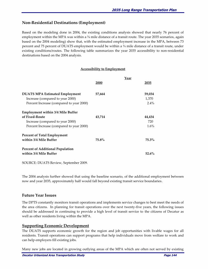
2035 Long Range Transportation Plan
Decatur Urbanized Area Transportation Study Page 144
Non-Residential Destinations (Employment)
Based on the modeling done in 2004, the existing conditions analysis showed that nearly 76 percent of
employment within the MPA was within a ¾ mile distance of a transit route. The year 2035 scenarios, again
based on the 2004 modeling) show that, with the estimated employment increase in the MPA, between 73
percent and 75 percent of DUATS employment would be within a ¾ mile distance of a transit route, under
existing conditions/routes. The following table summarizes the year 2035 accessibility to non-residential
destinations based on the 2004 analysis.
Accessibility to Employment
Year
2000 2035
DUATS MPA Estimated Employment 57,664 59,034
Increase (compared to year 2000) 1,370
Percent Increase (compared to year 2000) 2.4%
Employment within 3/4 Mile Buffer
of Fixed-Route 43,714 44,434
Increase (compared to year 2000) 720
Percent Increase (compared to year 2000) 1.6%
Percent of Total Employment
within 3/4 Mile Buffer 75.8% 75.3%
Percent of Additional Population
within 3/4 Mile Buffer 52.6%
SOURCE: DUATS Review, September 2009.
The 2004 analysis further showed that using the baseline scenario, of the additional employment between
now and year 2035, approximately half would fall beyond existing transit service boundaries.
Future Year Issues
The DPTS constantly monitors transit operations and implements service changes to best meet the needs of
the area citizens. In planning for transit operations over the next twenty-five years, the following issues
should be addressed in continuing to provide a high level of transit service to the citizens of Decatur as
well as other residents living within the MPA.
Supporting Economic Development The DUATS supports economic growth for the region and job opportunities with livable wages for all
residents. Transit operations can support programs that help individuals move from welfare to work and
can help employers fill existing jobs.
Many new jobs are located in growing outlying areas of the MPA which are often not served by existing
2035 Long Range Transportation Plan
Decatur Urbanized Area Transportation Study Page 145
transit routes. Commercial development that is common along major highways at the edges of the
urbanized area is especially dependent on low-income residents to fill the entry-level jobs in retail,
restaurants, hotels, and other businesses. By law, current transit services are primarily available in Decatur
and are limited or non-existent in many neighboring villages and outlying areas, making it difficult for city
residents to travel by transit to jobs outside of the City. This creates a job-housing mismatch that could
potentially be mitigated by increasing and improving public transportation services.
Access for the Older Adults, Disabled, and Disadvantaged Populations Public transportation is a vital component in providing mobility to older adults, disabled, and
disadvantaged in the Decatur urbanized area. Public transportation can provide the basic mobility needed
to access employment opportunities, health care facilities, daily shopping activities, and other basic
community services.
The Americans with Disabilities Act (ADA) of 1990 is civil rights legislation that was intended to remove
barriers that limit community opportunities for disabled individuals. The ADA requires fixed route transit
operators to provide complementary paratransit services for persons with disabilities who are unable to
use the fixed route bus system. FTA requires that this service be provided to and from locations within a ¾
mile distance on either side of a bus route, even if that is beyond the normal service area for the transit
system. For Decatur that means that ADA paratransit service is provided to most of the Village of Forsyth
and to part of the villages of Harristown and Long Creek. The ADA also mandated changes in fixed-route
transit services to make them more accessible to persons with disabilities, such as the use of wheelchair lifts
and audible stop announcements on buses.
Projects to improve accessibility to public transportation, including new and repaired sidewalks, bus
shelters and benches, and improved transit signage should all be considered and incorporated into the
transportation planning process. Furthermore, creating accessible transit centers, vehicles, and services
would help reduce the number of riders needing to use more expensive, dedicated paratransit resources.
In addition, design elements intended to provide access for people with disabilities create a more
“consumer friendly” system, the benefits of which extend to the general population.
Expanded Services Year 2035 population and employment projections suggest that the areas of Forsyth and Mt. Zion could see
substantial residential and non-residential growth over the next twenty-five years. The construction of the
SE Beltway could create residential and employment opportunities in the Southeast area of the MPA that
would fall beyond current transit service boundaries. This further emphasizes the future year need for
transit service to be extended beyond current boundaries to connect area residents with new job
opportunities.
The DPTS Planning Study, completed in September 2001, concluded that there appears to be little demand
in the County to warrant the extension of public transportation beyond the current city boundaries in the
near future.3 The study further found that the single biggest desire of city residents was for extended
service hours and Sunday service.4 Opportunities for service expansion should be closely monitored to
identify potential areas to be served by transit.
Schedule Adherence The DPTS Planning Study, completed in September 2001, identified schedule adherence as a concern.5 This
was also supported by bus drivers who noted several locations throughout the service area that resulted in
travel delays. Among the concerns were at-grade rail crossings that frequently resulted in travel delays.
Given the pulse system used by DPTS, that coordinates transfers at the downtown Transit Center, it is
extremely important that the individual transit routes adhere to the set schedule. Opportunities to

2035 Long Range Transportation Plan
Decatur Urbanized Area Transportation Study Page 146
minimize or eliminate travel delay for transit vehicles should be considered in any transit planning studies
as well as potential rail and/or roadway improvements.
Potential Improvements
Potential transit improvements were identified to help improve operations within the MPA. The DPTS
Planning Study identified five points as the basis for transit system recommendations. These
improvements included the following:
Minimize loops on routes and thereby eliminate some of the poorest performing route segments in
the system;
Emphasize additional service in the central city area where the greatest propensity for ridership
exists;
Offer extended service hours and Sundays across the system;
Call for the development of Decatur Area Ride, a service that will allow for extended service in low
density areas and provide broader coverage for DPTS services; and,
New service to Mt. Zion.
___________________________ 3 Decatur Public Transit System Planning Study, September 2001, page 78, Section 7.8. 4 Decatur Public Transit System Planning Study, September 2001, page 74, Section 7.3. 5 Decatur Public Transit System Planning Study, September 2001, page 71, Section 7.2.
Some of the recommendations listed above have been implemented by DPTS, such as eliminating loops
and extending service hours. Other potential improvements and potential recommendations that should
be considered to improve transit operations throughout the MPA include the following.
Creation of a Regional Transit Board
Currently, DPTS service covers primarily the City of Decatur with limited service to Forsyth, Harristown,
and Long Creek. In order to extend public transportation beyond existing limits, the creation of a regional
transit board to oversee transit operations should be considered. The proposed transit board would consist
of representatives from Decatur, Macon County, Forsyth and Mt. Zion, as well as other interested
communities and agencies.
The most significant obstacle to the extension of service is funding. Potential new service areas would need
to contribute funds to cover operating and capital costs. A regional transit board could be in a position to
better address future year transit needs for the entire MPA.
Additional Transfer Facilities One potential service enhancement would be the development of additional transfer facilities throughout
the MPA. The DPTS planning study considered the development of community transit centers that would
be located on the perimeter of the service area boundary. Individuals living beyond the service boundaries
could access the community transit centers via proposed route deviation/demand response zones. For
example, paratransit vans could be used in the less populated areas at the edge of the MPA, taking riders to
and from community transit centers that are served by fixed route buses.
While existing transit operations may not warrant additional transfer facilities, the consideration of
additional transfer facilities should be monitored within future transit planning activities to determine if
such improvements would improve transit mobility throughout the MPA.

2035 Long Range Transportation Plan
Decatur Urbanized Area Transportation Study Page 147
Bicycles on Buses Bicycle on buses programs encourage the integration of travel between bicycle and transit vehicles. Bicycle
on buses allows a cyclist to mount the bicycle on the front of the transit vehicle and then ride the bus to the
desired location. Such programs would provide increased accessibility to cyclists throughout the MPA and
in some instances could help individual’s access job opportunities that might otherwise be inaccessible.
Transit Oriented Development (TOD) Transit Oriented Development (TOD) encourages land use and development decisions/ policies that
support transit operations and ultimately help promote transit usage. Encouraging dense, mixed-use
developments that are easily accessible via walking or bicycling can promote transit usage. Context
Sensitive Solutions (CSS) can also encourage and promote alternative transportation modes such as public
transit. Providing new/repaired sidewalks, or other pedestrian/bicycle friendly facilities that would link to
transit services, can be incorporated with roadway or other transportation improvements and can
ultimately help support transit operations by providing improved connections.
Bicycle Compatibility Index
The BCI review was completed using the year 2030 traffic projections to identify potential changes that
may occur in the bicycle compatibility between existing year conditions and year 2030 conditions. Upon
review, with roadway conditions having changed very little, the BCI is continued from 2030 out to 2035.
The BCI analysis done in 2004 measured on-road facilities only and did not factor in the presence or
construction of off-road bicycle facilities (such as multi-use trails that might run parallel to a roadway
corridor). The following section summarizes the bicycle analysis.
Year 2035 Bicycle Compatibility In 2004, Year 2030 traffic projections were used to evaluate the potential bicycle compatibility throughout
the MPA. Those projections continue through 2035. The use of the BCI helped to identify potential
transportation corridors where bicycle improvements or enhancements may be warranted.
It was found that the majority of roadways within the MPA dropped from generally acceptable bicycle
compatibility for existing conditions to a moderately low compatibility for year 2035 conditions. This
would indicate that the average bicyclist would feel somewhat to very uncomfortable if riding strictly on
roadways within the MPA. The BCI analysis highlighted the need for improved bicycle and pedestrian
crossings of Lake Decatur, most major collectors and arterials and over I-72. Comments from Decatur Bike
Club members and persons interested in alternative modes of transportation also cite the lack of sidewalks
in many areas of the MPA. The following map displays the results of the year 2030 BCI analysis which is
continued to 2035.
Based on this analysis, potential bicycle corridors are identified within the MPA. The corridors are
depicted on the map on next page. Corridor segment priorities will be detailed in the Metro Greenways
Plan 2010 update and are intended to be incorporated by reference into this LRTP.

2035 Long Range Transportation Plan
Decatur Urbanized Area Transportation Study Page 148

2035 Long Range Transportation Plan
Decatur Urbanized Area Transportation Study Page 149
Future Year Issues
Lake Decatur Crossings As identified in the existing conditions and future year conditions analyses, Lake Decatur crossings are a
primary concern regarding bicycle travel within the MPA. To provide a true regional bicycle network will
require improved Lake Decatur crossings.
One potential improvement is the coordination of bicycle facilities into the design of the SE Beltway. A
specific design issue relating directly to bicycle travel is incorporated into the design of a new bridge
crossing over Reas Bridge Road. The new bridge crossing is planned to be four lanes and should
accommodate bicyclists and pedestrians. Other existing Lake Decatur crossings should also be evaluated
to determine how they might be retrofitted to provide adequate bicycle and pedestrian accommodations.
Bicycle Travel in Downtown Decatur The current multi-use trail system serves primarily the outer edges of the MPA. Bicycle travel in
downtown Decatur is limited by existing roadway configurations which do not support bicycle travel. One
recent project helps in providing a safe route to the CBD, that being the construction of the dedicated bike
and pedestrian way along West Main Street to Millikin University. Opportunities to improve bicycle travel
along existing roadways should be considered as part of any roadway reconstruction project throughout
the MPA.
A detailed bicycle and pedestrian study should be completed in FY 2010 which will provide updated,
potential linkages between the CBD, the transit center and other destinations. Consistent signage, bicycle
parking, and on-street facilities should be identified and provided in various locations in the CBD to
improve bicycle travel in the downtown area.
Safe Routes to School Safe Routes to School is a category which was included as part of the new Federal transportation
legislation. In 2009, Decatur was awarded a Safe Routes to School grant for sidewalk improvements in the
vicinity of Harris Elementary School. Providing safe routes to school is an important consideration and
should be incorporated in the planning and development of the MPA bicycle network.
Potential Improvements
Context Sensitive Solutions Context Sensitive Solutions (CSS) is an interdisciplinary approach that seeks effective, multimodal
transportation solutions by working with stakeholders to develop, build and maintain cost-effective
transportation facilities which fit into and reflect the project's surroundings - its "context". Through early,
frequent, and meaningful communication with stakeholders, and a flexible and creative approach to
design, the resulting projects improve safety and mobility for the traveling public, while preserving and
enhancing the scenic, economic, historic, and natural qualities of the settings through which they pass.2
Potential CSS applications should include prioritizing bicycle and pedestrian improvements with any new
or improved roadway projects. Bicycles and pedestrians should be a primary consideration in any
transportation planning project within the MPA rather than being considered as an afterthought to
roadway improvements.
2 IDOT Website. (http://www.dot.state.il.us/css/basics.html)
2035 Long Range Transportation Plan
Decatur Urbanized Area Transportation Study Page 150
Bicycles on Buses
As discussed in the transit operations section, bicycles on buses is a program that supports intermodal
connections and increased accessibility throughout the MPA. A bicycle on buses program allows a
bicyclist to transport a bicycle on the front of a transit vehicle. This program helps expand the existing
MPA bicycle network by allowing bicyclists to travel along areas that otherwise might be inaccessible for
bicyclists. This program would immediately help alleviate issues, such as the Lake Decatur crossings and
bicycle travel downtown, while more permanent solutions and improvements are identified and
implemented to improve bicycle travel.
Bicycle Connections to New Development
New developments should be required to address bicycle and pedestrian accessibility. Efforts should be
taken to connect residential developments with existing and planned bicycle facilities. New development,
particularly in commercial areas, should provide adequate bicycle parking facilities to encourage bicycle
travel.
Comprehensive Review of Bicycle Facilities An updated comprehensive review of existing and planned bicycle facilities should be completed to
identify current levels of bicycle usage and the most appropriate corridors for bicycle and pedestrian
facilities. The existing bicycle planning document was developed in the late 1990’s. A comprehensive and
detailed update of that document should be completed in FY 2010. It will greatly benefit bicycle planning
and network development within the MPA.
Rail Operations
Future year rail operations have historically been the primary responsibility of the rail companies. But,
recently it appears that there is a willingness to explore some cooperative stances which could prove
beneficial to the rail companies, local governments and the traveling public. The following issues that need
to be addressed as part of the transportation planning.
However, an opportunity may exist which could address each of the items individually, yet do so in a
collective manner. It is being proposed by the Technical Committee to engage the major parties and
stakeholders to begin an ongoing dialogue which would focus on studying the rail network as a whole.
The objectives would include increased cooperation and communication between the parties, sharing of
infrastructure, rail improvements, rail crossing improvements, freight consolidation, trans-load
opportunities, improved freight logistics, passenger rail opportunities, highway/rail corridor
improvements, with an added benefit of being able to close a number of at grade rail crossings. The
discussion is intended to start early in FY 2010.
Future Year Issues
At-Grade Crossings
Traffic operations at at-grade rail crossings is a primary concern within the MPA. Local agencies should
continue to coordinate continuing maintenance with the private rail companies and existing at-grade
crossings should constantly be monitored to determine if upgrades in traffic control devices or other
improvements are needed (i.e. install gates, install flashing lights, grade separation, etc.).

2035 Long Range Transportation Plan
Decatur Urbanized Area Transportation Study Page 151
Intermodal Opportunities The MPA has the potential in future years to become a primary area for the movement of freight/goods
within the region. The existing rail service already in place and close access to the Decatur Airport and
nearby industrial park make the MPA an ideal location for an intermodal facility. The presence of the
Foreign Trade Zone and Customs at the Decatur Airport is also a significant resource to support
intermodal opportunities.
Construction of the SE Beltway and the widening of US 51 (outside the MPA) would further support
potential intermodal connections. Finally, a rail spur accessing the Airport industrial park would promote
intermodal connections.
Travel Delays Existing rail operations, and specifically at-grade rail crossings, within the MPA often result in travel
delays for motorists and transit vehicles. Some at-grade crossings in the MPA exceed 60 train operations
per day. Assuming a conservative estimate of 2 minutes of delay per train crossing would result in
potentially two hours of travel delay per day at some at-grade crossings.
Travel delays would increase over the next twenty-five years if rail traffic increases. The development of
an intermodal facility would almost certainly increase rail operations and would further add to the travel
delays. The related impacts of increase rail traffic in the MPA, in particular with the construction of an
intermodal facility, need to be addressed.
Intermodal Facility The extensive rail network in the MPA and the lack of adequate intermodal facilities, make the area a
prime candidate for an such a transportation facility. While current freight levels may not warrant such a
facility, this should be closely monitored to determine when and if an intermodal facility should be
constructed. An intermodal facility could benefit the area by supporting economic development
throughout the region.
Grade-Separated Facilities One potential improvement that would benefit both rail and roadway operations would be the study and
construction of grade-separated facilities (i.e., rail overpasses or underpasses) at certain locations.
Construction of grade-separated facilities is most areas within the MPA be difficult due to right-of-way
restrictions, land acquisition costs, and the expense of the separation. The private rail companies would
obviously need to support such improvements.
One particular crossing that was identified for possible grade separation in the 2030 LRTP was the at-grade
crossing along Eldorado Street (between Front and Hilton). Additional grade separation along 22nd Street
and 27th Street are other possible locations to consider. Grade-separated facilities could greatly reduce
travel delays for the various transportation modes including private vehicles, transit buses, and ground
freight movement.
Passenger Rail Over the past year, DUATS has been involved with a local initiative intended to bring Amtrak passenger
rail service to Decatur. There has not been passenger service available to the community decades. The
benefits of such service are obvious. However, community ridership and support will be crucial in
attempts to initiate service. Preliminary plans on how to address the issues have been completed. A formal
request for a feasibility study are pending delivery to IDOT. It is hoped that this request will be completed
and delivered in the early part of 2010.

2035 Long Range Transportation Plan
Decatur Urbanized Area Transportation Study Page 152
High Speed Passenger Rail In June, 2009, the Director of the Midwest High Speed Rail Association (MWHSRA), various dignitaries
and interested citizens attended a public meeting on the potential and possibilities of constructing
passenger high speed rail between Chicago and St. Louis. The currently proposed route would run
between Champaign and Springfield on a dedicated rail line. MWHSRA was promoting the rail project as
supporting train speeds as high as 220 MPH. According to MWHSRA such service is economical, efficient,
and an investment well worth making. At 220 mph, a high speed train could transport passengers from
Chicago to Decatur in an hour and five minutes. A study commissioned by the Midwest High-Speed Rail
Association has demonstrated that this is an attainable and valuable goal for Illinois transit. The study
explored the feasibility of a route from Chicago to Saint Louis via major population centers in the corridor
between those cities. The findings concluded that a rail route through Decatur, an important center of
business in Illinois, would be optimal and allow for electrically powered trains that could operate at such
high speeds. This high speed rail project would also bring jobs, revenue, and fast transit options to the
citizens of Decatur. This event is part of a larger daylong rally that will also involve events in Champaign-
Urbana and Springfield.
Current federal funding does not support 220 mph service. The study's proof of the feasibility of 220 mph
service will hopefully inspire an even greater federal commitment to high speed rail funding.
Planning for and possibly constructing such a massive transportation project would take on immense
significance in the MPA and the region. Existing freight lines are numerous, the number of trains in and
out of the MPA daily is large and safety, security, operation, etc., would warrant a substantial investment
of time, finances and cooperation. Even with the obstacles, it is in the MPA’s best interest to pursue high
speed passenger rail service in Decatur.
New Technology New technology in rail operations, such as at at-grade crossings should be identified and considered for
possible application within the MPA. This technology could include simply installing new gates and
flashing lights to improve safety. It may also involve yet to be defined technology which would improve
logistical efficiencies.

2035 Long Range Transportation Plan
Decatur Urbanized Area Transportation Study Page 153
Airport Operations
Continued investment in the Decatur Airport is necessary to maintain and enhance its position as a
passenger facility and airfreight hub of regional significance. The following are future year issues
regarding the Decatur Airport that need to be considered as part of the transportation planning process.
Future Year Issues
Airport Expansion Expansion plans are critical to the continued development and success of the Decatur Airport.
Coordinated land use and transportation planning is needed to ensure that airport expansion plans can be
implemented. In particular, it is important that new commercial and residential development does not
encroach on the airport. Furthermore, the proposed alignment of the SE Beltway needs to accommodate
future airport expansion.
Development of the Industrial Park
A goal of the region is to attract new businesses and industries to the area. A goal of the LRTP is to
support economic development opportunities within the MPA. Development of the airport and industrial
park are considered important to attracting new economic development opportunities to the area.
Improved Accessibility The Decatur Airport is located on the eastern edge of the city and can be accessed via U.S. Route 36, IL
Route 105, and IL Route 121. There is currently no direct access to the airport by interstate or other limited-
access highways. Improved accessibility is critical to the continued development of the Decatur Airport.
Potential Improvements
Surrounding Development It is important to discourage additional residential development around the airport through zoning
changes, especially on the north side of the airport where noise levels are likely to be greatest and potential
exists for more noise-compatible land uses, such as light industry and air freight operations. The update of
the airport master plan will identify airport expansion plans which will coordinate the future development
of the airport with surrounding land uses and related transportation projects.
Accessibility Improvements
The construction of the SE Beltway could greatly improve accessibility to the Decatur Airport and the
industrial park. The final alignment did take into account future runway extension plans and should
provide primary access to the airport via IL Route 105 (E. William Street) or U.S. Route 36. If the SE
Beltway is not built, or is delayed for several years, it is important to explore other alternatives to improve
accessibility for vehicles and for truck access between I-72 and the airport and industrial park. Improved
access will facilitate freight movement within the MPA.
Another important roadway improvement is the construction of the Twin Bridge Road project near U.S.
Route 36. This project will improve access between the route and the airport/industrial park. This project
is currently in the design stage and should be constructed in the near future.

2035 Long Range Transportation Plan
Decatur Urbanized Area Transportation Study Page 154
As an alternative, constructing a road between the north end of Twin Bridge and Airport Road would also
provide much needed and improved access to the south portion of the Airport property. Both options are
included in this LRTP.
Intermodal Facility The industrial park is an ideal location for intermodal transfers between ground, rail, and air
transportation. A detailed study should be considered to identify the feasibility of developing an
intermodal facility within the MPA.
2035 Long Range Transportation Plan
Decatur Urbanized Area Transportation Study Page 155
CHAPTER 12. FINANCIAL CAPACITY AND ANALYSIS
This chapter summarizes the financial analysis of potential transportation investments. Estimated
revenue from existing and proposed funding sources is compared with estimated project costs of
constructing, maintaining, and operating the total (existing and planned) transportation system to the
year 2035.
Background
Historically, LRTP’s often contained "wish lists" of projects that had very little chance of ever being
constructed. The planning regulations of ISTEA and TEA-21 brought about a change that required
MPOs to consider the financial implications of their planning efforts. To this end, the federal planning
regulations put in place the requirement for financial constraint of these documents. In 23 CFR
322(b)(11), it is stated that transportation plans shall:
Include a financial plan that demonstrates the consistence of proposed transportation
investments with already available and projected sources of revenue. The financial plan shall
compare the estimated revenue from existing and proposed funding sources that can
reasonably be expected to be available for transportation uses, and the estimated costs of
constructing, maintaining and operating the total (existing plus planned) transportation
system over the period of the plan. The estimated revenue by existing revenue source (local,
State, Federal, or private) available for transportation projects shall be determined and any
shortfalls identified. Proposed new revenues and/or revenue sources to cover shortfalls shall
be identified, including strategies for ensuring their availability for proposed investments.
Existing and proposed revenues shall cover all forecasted capital, operating, and maintenance
costs. All cost and revenue projections shall be based on the data reflecting the existing
situation and historical trends.
Federal planning regulations require that LRTP’s be fiscally constrained in that all transportation
projects proposed to be constructed or equipment that was to be purchased would have to include the
specific funding sources that would pay for the improvements or equipment. Those projects that did
not have funding sources and amounts attached could still be included in the LRTP but only as an
Illustrative or future project.
This LRTP has projects which are fiscally constrained, those that are partially constrained and others
that are so long range they have an estimated cost based on 2009 dollars.
Funding for DUATS transportation maintenance, improvement and transit projects come from a
variety of Federal, State, local and private sources. The Federal government is the primary source of
funding for transportation systems in the United States. These funds come from federally assessed
user fees, motor and aviation fuel taxes, and landing fees. They are apportioned back to the states on a
formula basis. The primary source of revenue at the Federal and State levels includes motor fuel
taxes, vehicle registration fees, special motor carrier fees, parking fees and toll fees. Finance at the
county and municipal levels are primarily based on property taxes, sales taxes, and special
assessments. The private sector, such as developers and business associations, often support
transportation projects through impact fees, right-of-way donations, and cost sharing.
Federal, State, local agencies and private developers have invested hundreds of millions of dollars in
the DUATS transportation system over the past several decades. In the late 1990’s, programs such as
2035 Long Range Transportation Plan
Decatur Urbanized Area Transportation Study Page 156
TEA-21 and Illinois FIRST significantly increased Federal and State funding authorizations above
previous levels. However, the cost of maintaining the existing transportation infrastructure is
continually increasing as the facilities age. The challenge that DUATS faces in the future is to balance
the maintenance of the existing transportation infrastructure with a possibly declining population,
potential fund decreases, expected increases in the cost of materials and maintenance, while at the
same time identifying adequate funding for the construction of new transportation facilities.
Roadways
The following sections compare the total costs against estimated funding levels.
Roadway Improvement Costs
Roadway improvement and costs were identified using the current TIP (FY 2010 to FY 2013), Capital
Improvement Plans (CIP) and the August 2009, Technical and Policy Committees decisions. For those
projects not included in the TIP, general planning level construction and right-of-way costs were
developed using general cost estimates provided by the member entity responsible for the particular
project(s). In some case, such as the SE Beltway project, cost estimates were obtained from this
project’s on-going study since the corridor has been identifying and Federally approved.
It is important to consider the following when reviewing future project cost estimates. First, it is
extremely difficult to identify a specific year in which any particular project might be constructed.
Therefore, all estimated costs are based on the best available estimates available at this time. Second,
project details regarding design, engineering, and construction are most often not specific enough and
therefore, the estimated costs represent a very general planning level estimate. As projects proceed to
the detailed planning and engineering phases, which will result in more accurate estimates, the project
cost estimates contained in this LRTP should be updated.
For the purpose of the LRTP analysis, projects were grouped into three categories. The categories
were identified as committed projects (construction is probable between 2011 and 2013), planned
projects (construction possible 2013 to 2035) and future projects (construction possible beyond 2035).
The category terminology (committed, planned and future) was used simply for classifying the
various transportation projects. It does not guarantee that any particular project will actually be
constructed. Furthermore, there is no guarantee that a specific project will be constructed during the
time frame identified. The design, engineering, and construction of the specific roadway
improvements identified in this LRTP depend heavily on the availability of transportation funds and
many other factors.
Based on the identified projects and estimated costs, it is projected that the roadway and trail
improvement projects over the next 25 year period will total approximately $415.5 million in 2009
dollars. The SE Beltway alone is estimated to account for approximately one-half of this total at an
estimated $198 million. The potential roadway improvement costs are summarized below.
Projects in BOLD are Committed while all others are considered Illustrative. The Committed projects
are shown in their respective Year of Expenditure dollars, while all others are shown as an estimated
cost based on the best information available. As noted on the previous page, these projects are so far
into the future that cost estimates, even adjusted for inflation, simply cannot be assumed to be truly
accurate.

2035 Long Range Transportation Plan
Decatur Urbanized Area Transportation Study Page 157
Roadway and Trail Improvement Cost Estimates (2009 Dollars)
IDOT Projects
Repaving 1.1 miles of U.S. Route 36, Railroad to IL Route 105 .......................... $ 1,200,000
Bridge Rehabilitation U.S. 51 over I-72 ..................................................................... $ 4,000,000
Repair/Resurface 4.8 mi. Rt. 36, Bus. Rt. 51 to Route 51 ......................................... $ 6,020,000
Resurfacing 3 mi. Rt. 48, Bus. 51, IL 105 & Rt. 48 to US 51 ..................................... $ 2,260,000
Bridge Rehabilitation, U.S. Route 51 at NSRR ......................................................... $ 2,900,000
Bridge Replacement, Rt 51 (NB & SB) over Sangamon River ................................ $24,650,000
Patch/Repave 5 mi. of I-72, Beginning 1.5 mi. E. of Rt. 48 ...................................... $ 8,800,000
Repair/Resurface 13 mi. of Rt. 48, Rt. 121 to I-72 at Argenta ................................. $ 4,800,000
Resurface 2 miles of IL Route 48, Marietta St. to South Side Dr. ........................... $ 1,420,000
Resurface 3 miles of IL Route 121, Damon Ave. to Lakeshore Dr. ....................... $ 2,650,000
Resurface 3 miles of Main Street from C.H. 21 to Wyckles Road .......................... $ 1,120,000
Resurface 10 mi. of Old Route 36, Sangamon Co to U.S. Route 36 ....................... $ 3,690,000
Bridge Replacement, U.S. Route 51, Spring Creek at Main Street ........................ $ 3,110,000
Bridge Replacement, Bus. Route 51, Spring Creek at Main Street ........................ $ 2,780,000
Decatur Projects
MacArthur Bridge Replacement over Stevens Creek .......................................... $ 1,000,000
Eldorado Streetscape Enhancements, Church to Front Streets........................... $ 1,547,000
Garfield Ave. Bridge Reconstruction over CNRR ................................................ $ 990,000
Lost Bridge Road Improvements ............................................................................. $ 475,000
South Shores Bridge Reconstruction over Sand Creek ....................................... $ 1,300,000
Brush College Road Improvements .......................................................................... $13,000,000
Downtown Truck Route Relocation .......................................................................... $ 4,692,000
Center Street Bridge Replacement over Stevens Creek .......................................... $ 1,150,000
27th Street Reconstruction- Fairies Parkway to Route 48 ...................................... $ 6,900,000
Jasper Street Reconstruction, Eldorado to Pershing Road ..................................... $ 1,700,000
Jasper Street Underpass Reconstruction ................................................................... $13,000,000
Ash Avenue Extension, MLK Drive to Route 48 ..................................................... $20,000,000
Mount Zion Projects
Construction of Main Street / Henderson Street By-Pass ................................... $ 1,537,000
Repaving Wildwood Courts ..................................................................................... $ 226,000
Main Street Bridge Rehabilitation ............................................................................. $ 500,000
Constructing 0.217 mi. of Fletcher Park Rd., E/W section ...................................... $ 460,800
Constructing 0.18 mi. of Fletcher Park Rd.., N/S section ........................................ $ 404,300
Construction of Phase 2, Henderson Street .............................................................. $ 635,000
Lewis Park Drive Extension ....................................................................................... $ 142,200
Repair/Resurface Dee Lee Lane ................................................................................. $ 104,900
Reconstruct Crestview Addition ............................................................................... $ 237,700
Reconstruct East Roberts Street ................................................................................. $ 139,300
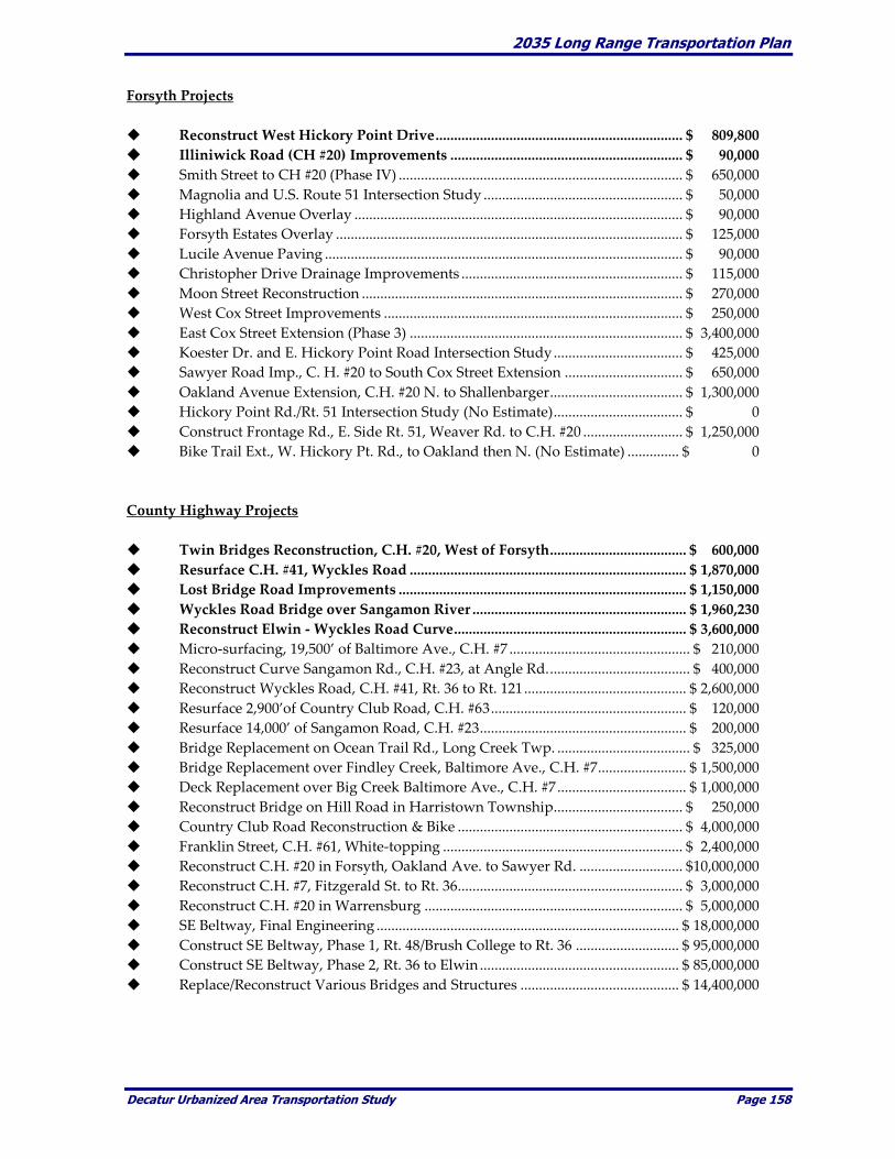
2035 Long Range Transportation Plan
Decatur Urbanized Area Transportation Study Page 158
Forsyth Projects
Reconstruct West Hickory Point Drive ................................................................... $ 809,800
Illiniwick Road (CH #20) Improvements ............................................................... $ 90,000
Smith Street to CH #20 (Phase IV) ............................................................................. $ 650,000
Magnolia and U.S. Route 51 Intersection Study ...................................................... $ 50,000
Highland Avenue Overlay ......................................................................................... $ 90,000
Forsyth Estates Overlay .............................................................................................. $ 125,000
Lucile Avenue Paving ................................................................................................. $ 90,000
Christopher Drive Drainage Improvements ............................................................ $ 115,000
Moon Street Reconstruction ....................................................................................... $ 270,000
West Cox Street Improvements ................................................................................. $ 250,000
East Cox Street Extension (Phase 3) .......................................................................... $ 3,400,000
Koester Dr. and E. Hickory Point Road Intersection Study ................................... $ 425,000
Sawyer Road Imp., C. H. #20 to South Cox Street Extension ................................ $ 650,000
Oakland Avenue Extension, C.H. #20 N. to Shallenbarger .................................... $ 1,300,000
Hickory Point Rd./Rt. 51 Intersection Study (No Estimate) ................................... $ 0
Construct Frontage Rd., E. Side Rt. 51, Weaver Rd. to C.H. #20 ........................... $ 1,250,000
Bike Trail Ext., W. Hickory Pt. Rd., to Oakland then N. (No Estimate) .............. $ 0
County Highway Projects
Twin Bridges Reconstruction, C.H. #20, West of Forsyth ..................................... $ 600,000
Resurface C.H. #41, Wyckles Road ........................................................................... $ 1,870,000
Lost Bridge Road Improvements .............................................................................. $ 1,150,000
Wyckles Road Bridge over Sangamon River .......................................................... $ 1,960,230
Reconstruct Elwin - Wyckles Road Curve ............................................................... $ 3,600,000
Micro-surfacing, 19,500’ of Baltimore Ave., C.H. #7 ................................................. $ 210,000
Reconstruct Curve Sangamon Rd., C.H. #23, at Angle Rd. ...................................... $ 400,000
Reconstruct Wyckles Road, C.H. #41, Rt. 36 to Rt. 121 ............................................ $ 2,600,000
Resurface 2,900’of Country Club Road, C.H. #63 ..................................................... $ 120,000
Resurface 14,000’ of Sangamon Road, C.H. #23 ........................................................ $ 200,000
Bridge Replacement on Ocean Trail Rd., Long Creek Twp. .................................... $ 325,000
Bridge Replacement over Findley Creek, Baltimore Ave., C.H. #7 ........................ $ 1,500,000
Deck Replacement over Big Creek Baltimore Ave., C.H. #7 ................................... $ 1,000,000
Reconstruct Bridge on Hill Road in Harristown Township................................... $ 250,000
Country Club Road Reconstruction & Bike ............................................................. $ 4,000,000
Franklin Street, C.H. #61, White-topping ................................................................. $ 2,400,000
Reconstruct C.H. #20 in Forsyth, Oakland Ave. to Sawyer Rd. ............................ $10,000,000
Reconstruct C.H. #7, Fitzgerald St. to Rt. 36 ............................................................. $ 3,000,000
Reconstruct C.H. #20 in Warrensburg ...................................................................... $ 5,000,000
SE Beltway, Final Engineering .................................................................................. $ 18,000,000
Construct SE Beltway, Phase 1, Rt. 48/Brush College to Rt. 36 ............................ $ 95,000,000
Construct SE Beltway, Phase 2, Rt. 36 to Elwin ...................................................... $ 85,000,000
Replace/Reconstruct Various Bridges and Structures ........................................... $ 14,400,000

2035 Long Range Transportation Plan
Decatur Urbanized Area Transportation Study Page 159
Park District Projects
Engineering Work for West End Bridge in Fairview Park ..................................... $ 50,000
Stevens Creek Bike Trail (Phase 1), Fairview to Greendell Park ......................... $3,700,000
West End Bridge, Fairview Road, Fairview Park ........................................................ $ 850,000
Bike Trail in conjunction with Country Club Rd. Reconstruction ............................ $ 500,000
West End Road Reconstruction, Fairview Park ........................................................... $ 80,000
Twin Bridge Road Project ............................................................................................ $ 2,000,000
Repair/Repave Fairies Park Road ................................................................................. $ 325,000
MCCD Projects
Rock Springs Trail Improvements ............................................................................... $ 39,600
Ft. Daniels Trail Improvements ..................................................................................... $ 88,000
Projected Revenues Projected revenues, or funding estimates, were developed to identify gaps between the estimated
roadway improvement costs and estimated funding levels to the year 2035. As with the estimated
roadway improvement costs, the estimated funding levels are extremely difficult to predict. The
projected funding levels provided in the following table are intended to provide a general comparison
between the estimated roadway improvement costs and estimated funding levels. It should be noted
that the estimated maintenance costs and funding sources are displayed in year 2009 dollars to
provide a consistent comparison to the estimated roadway improvements, which are also presented in
year 2009 dollars.
The estimated funding resources reasonably available over the next twenty five years are shown
below. The “Total Estimated Funding Resources” reasonably expected to be available, shown below,
is the sum of four funding sources. These funding sources are Surface Transportation Urban (STU),
Surface Transportation Rural (STR), Highway Bridge Program (HBP) and Motor Fuel Tax (MFT). MFT
funds as used in this LRTP are equated to the amounts reported to DUATS by the various units of
government that were typically spent on “maintenance and operations” within their respective
jurisdictions in the base year of FY 2010, which is shown in the column “Annually” on Page 134. Those
figures are in FY 2010 dollars.
Funding amounts for STU, STR and HBP over the past four years are shown below.
STU STR HBP
FISCAL YEAR
2010 785,000 314,453 719,883
2009 777,129 317,875 503,083
2008 755,667 309,298 478,752
2007 633,142 255,286 449,512
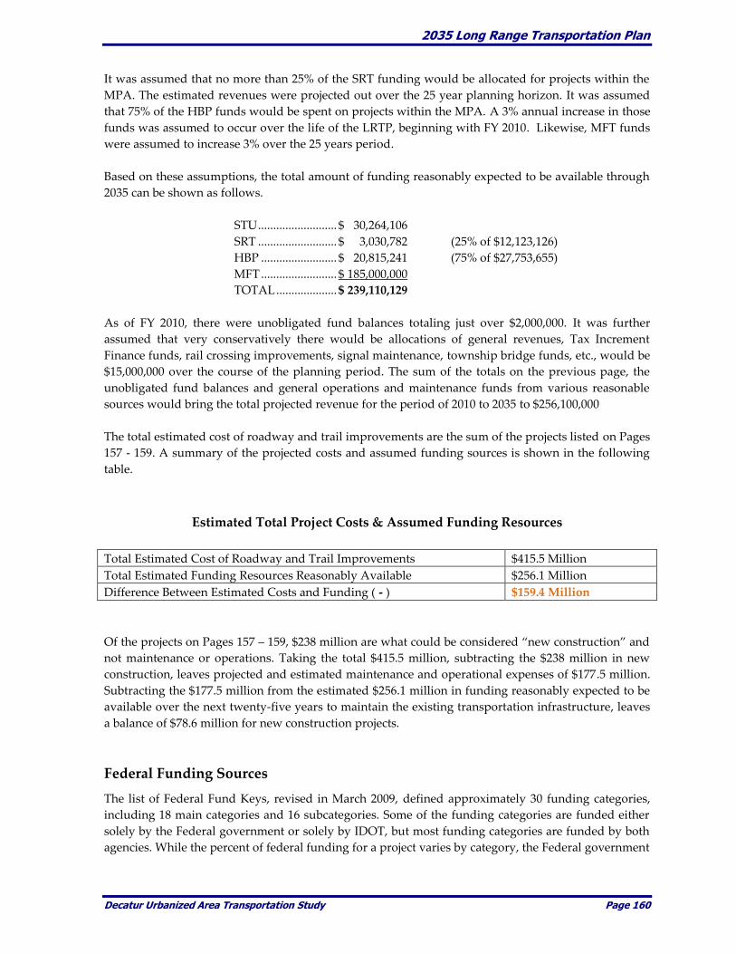
2035 Long Range Transportation Plan
Decatur Urbanized Area Transportation Study Page 160
It was assumed that no more than 25% of the SRT funding would be allocated for projects within the
MPA. The estimated revenues were projected out over the 25 year planning horizon. It was assumed
that 75% of the HBP funds would be spent on projects within the MPA. A 3% annual increase in those
funds was assumed to occur over the life of the LRTP, beginning with FY 2010. Likewise, MFT funds
were assumed to increase 3% over the 25 years period.
Based on these assumptions, the total amount of funding reasonably expected to be available through
2035 can be shown as follows.
STU .......................... $ 30,264,106
SRT .......................... $ 3,030,782 (25% of $12,123,126)
HBP ......................... $ 20,815,241 (75% of $27,753,655)
MFT ......................... $ 185,000,000
TOTAL .................... $ 239,110,129
As of FY 2010, there were unobligated fund balances totaling just over $2,000,000. It was further
assumed that very conservatively there would be allocations of general revenues, Tax Increment
Finance funds, rail crossing improvements, signal maintenance, township bridge funds, etc., would be
$15,000,000 over the course of the planning period. The sum of the totals on the previous page, the
unobligated fund balances and general operations and maintenance funds from various reasonable
sources would bring the total projected revenue for the period of 2010 to 2035 to $256,100,000
The total estimated cost of roadway and trail improvements are the sum of the projects listed on Pages
157 - 159. A summary of the projected costs and assumed funding sources is shown in the following
table.
Estimated Total Project Costs & Assumed Funding Resources
Total Estimated Cost of Roadway and Trail Improvements $415.5 Million
Total Estimated Funding Resources Reasonably Available $256.1 Million
Difference Between Estimated Costs and Funding ( - ) $159.4 Million
Of the projects on Pages 157 – 159, $238 million are what could be considered “new construction” and
not maintenance or operations. Taking the total $415.5 million, subtracting the $238 million in new
construction, leaves projected and estimated maintenance and operational expenses of $177.5 million.
Subtracting the $177.5 million from the estimated $256.1 million in funding reasonably expected to be
available over the next twenty-five years to maintain the existing transportation infrastructure, leaves
a balance of $78.6 million for new construction projects.
Federal Funding Sources
The list of Federal Fund Keys, revised in March 2009, defined approximately 30 funding categories,
including 18 main categories and 16 subcategories. Some of the funding categories are funded either
solely by the Federal government or solely by IDOT, but most funding categories are funded by both
agencies. While the percent of federal funding for a project varies by category, the Federal government
2035 Long Range Transportation Plan
Decatur Urbanized Area Transportation Study Page 161
typically provides 80 percent of the funding, with 20 percent of the funding matched by IDOT or a
local agency.
Of the 30 categories, DUATS has direct input into four Federal funding categories. Funding for all
other categories is determined by IDOT (through a statewide ranking process), by the Federal
government, or is not applicable to DUATS. The four categories that the MPO has direct input and/or
selection responsibility include:
Highway Bridge Program (HBR) - HBP Funds are provided to replace or rehabilitate structurally
deficient bridges on or off the system for the safe and expeditious transportation of the general public.
The funds are allotted to districts based on a formula involving square footage of eligible bridges.
Local governments are required to provide a twenty percent match.
Surface Transportation Urban (STU) – This category is for transportation needs within urbanized
areas with populations less than 200,000 and greater than 5,000. Funding is 80 percent Federal and 20
percent State and Local. Funds are allocated by census population and projects are selected by
DUATS. STP-U is administered by the State of Illinois for DUATS. STU money is allotted to MPO’s for
transportation projects such as road construction, reconstruction and bridge rehabilitation Ten percent
of all STU funds must be used for safety projects, which can be used for rail crossing improvements,
signals, and other accident-reducing methods of transportation improvement.
Surface Transportation Rural (STR) – This category is for transportation needs outside urbanized
areas with populations less than 200,000 and greater than 5,000. Funding is 80 percent Federal and 20
percent State and Local. STR money is made available for transportation projects such as road
construction, reconstruction and bridge rehabilitation in the more rural areas.
Surface Transportation Enhancements (STE) – Ten percent of STU funding is available for
enhancements such as] bike and pedestrian facilities, preservation of historic sites, scenic
beautification and other transportation related projects. The MPO must submit a letter stating their
support of the project, identifying funding, and attesting that the project is consistent with long range
transportation plans.
This is not to say that other funds and funding sources are not available. This LRTP did not attempt to
include sources that were not reasonably expected to be available or those that typically contribute a
very small amount to the funding resource pool.
State Funding Sources
State funding is administered by IDOT. Among the most common forms of funding are the
following:
Motor Fuel Tax (MFT) – The MFT is collected on each gallon of gas that is purchased. The State of
Illinois levies a tax of 19.0 cents per gallon of gasoline and 21.5 cents per gallon of diesel fuel for
operating motor vehicles and boats. The tax is included in the selling price so the user of the motor
fuel ultimately pays the tax. The tax is collected by the Department of Revenue and distributed to
local governments. To qualify for funding, municipalities must be incorporated. Municipalities
receive their funding based on population. Counties receive their allotment based on total license fees

2035 Long Range Transportation Plan
Decatur Urbanized Area Transportation Study Page 162
in the county. Townships must levy a 0.08 percent road and bridge tax to be eligible to receive the
money. Township allocations are based on total township mileage.
Truck Access Routes – Truck access routes have a special funding category available for designated
truck routes which may receive up to $30,000 per lane-mile and $15,000 per intersection for the
improvement of access.
Illinois Commerce Commission (ICC) – Another special funding source, offered by the State of
Illinois (Illinois Commerce Commission), can be used for rail crossings that are at grade with a street.
This funding can be used for new or upgraded rail crossings.
Economic Development Funds – Economic Development funds may be used for transportation
projects if the new or improved facility will attract or create jobs. This program can be used for
industrial, commercial and recreational projects if the project is necessary.
Likewise there are numerous other funding sources that may be available. This LRTP did not take into
account those funds which could not be reasonably expected to be available for the general
maintenance of existing infrastructure and/or construction of new roads or trails.
The available funding sources also do not take into account all funds that may be received by a
particular entity in any given year. For example, some communities use all of the MFT funding for
maintenance, while others use it for what they classify as “new construction.” This LRTP requires less
reliance on funding sources that cannot be reasonably expected to be available. The amount available
for new construction is much less than was included in the 2030 LRTP. With the passage of SAFETEA-
LU, which was not in effect in 2004, the requirement for fiscal constraint and reasonable expectation is
required.
Local Funding Sources
The basis of local funding of transportation projects in the local municipalities and Macon County is
primarily through Federal and State allocations and block grants. Additional revenues come from
property taxes, sales taxes, special assessments, and special tax districts. General funds for roadway
maintenance may be obligated from the general property, sales and other tax proceeds for
transportation purposes. While this represents a funding source, the trend in local government is to
use general fund property tax proceeds for operation and maintenance of general government.
Additional funding includes:
Township Bridge Program – Township Bridge Program funds are used to construct bridges twenty
feet or more in length for the safe transportation of school children, the movement of agriculture
equipment and products, rural mail routes, and the traffic needs of the general public. Funds are
allocated to each eligible road district based on the total township mileage. Townships must levy a
0.08 percent road and bridge tax to qualify for the allocation.
Bonds – Transportation projects may be financed utilizing bonded indebtedness. This method allows
a unit of government to raise capital through the sale of public bonds to be repaid with interest using
general property tax receipts, motor fuel tax, or revenue from the project upon completion. The City
of Decatur has utilized this financing alternative to complete several public transportation projects.
2035 Long Range Transportation Plan
Decatur Urbanized Area Transportation Study Page 163
Tax Increment Financing (TIF) – The TIF technique captures all increases in property tax resulting
from improvements to a property until such time as allowable project expenses have been paid.
Proposed improvements and planned expenditures are defined in a plan and must meet eligibility
requirements under the enabling legislation. City governments define the TIF district and program in
consultation with units of local government impacted by the proposed district.
Capital Improvement Program (CIP) – Funding for near-term (one to five years) transportation
projects are identified in the State’s multi-year program, a municipalities’ Capital Improvement
Program (CIP) and Macon County’s CIP. Estimates of near-term transportation funding is based on
appropriated levels of federal funding, cash flows of state funding sources, and city and county
bonding programs and general revenue sources.
Private Sector Funding Sources As a community grows, vacant land or farmland is often converted to urban uses. As part of that
growth, land developers pay the cost of infrastructure development including streets. Particularly as
it relates to commercial development and industrial development, developers pay a large share of
arterial and collector street widening, enhancement, or rehabilitation. The continued enforcement and
management of growth through subdivision code administration minimizes the cost to the
community.
When developing major roadways, units of local government may negotiate with private interests to
share in the development costs of arterial or collector streets that provide direct benefit to private
interests. The amount of money available using this technique is limited only by the degree of
commitment from the private sector and the willingness of the private sector to share in those costs.
Impact fees are costs assigned to new development for the maintenance of existing facilities.
Developers pay these fees with costs generally passed on to the eventual owners of the property.
Under Illinois law Special Service Taxing Districts may be established for the purpose of construction
and financing public improvements within a defined service area. It could be the practice of local
governments in Macon County to respond to citizen inquiries requesting that of special taxing
district(s) be created to fully assess interest within the proposed district. Projects that could be
considered under this financing method could include street lighting, street construction or
rehabilitation, and sidewalk construction.
A Special Assessment District is established under Illinois law for the purpose of financing and
providing certain public facilities. A special assessment district is established through a judicial
process that attempts to fairly allocate costs between private and public interests. These funds have
typically been used for utility projects and not transportation projects.
Transit Operations
A feasible transit service relies upon secure funding sources and sufficient revenue to support the
continuing operation and potential expansion of public transportation services. The purpose of this
analysis is to evaluate the financial feasibility of the DPTS to the year 2035. Transit operations can be
divided into two categories. The first is operating costs and the second is capital improvements.
These categories are described in the following sections.

2035 Long Range Transportation Plan
Decatur Urbanized Area Transportation Study Page 164
Operating Costs Operating costs for the DPTS service were approximately $5.2 million in FY 2009. The primary
funding sources for operating costs are provided at the Federal and State levels. Federal funding over
recent years has accounted for approximately 22% of the DPTS operating costs. The State of Illinois
currently reimburses the DPTS for 65% of eligible operating costs. Additional funding, making up
about 13% of operating expenses, is provided by the City of Decatur from property tax revenues, and
by other revenues generated by the Transit System including bus fares, transit passes, advertising
revenues and concession revenues.
In order to analyze potential future year transit financial conditions, it is necessary to make some
assumptions regarding future year operating costs and funding sources. Operating costs and funding
sources over the past five years were reviewed to identify a potential trend. Total operating costs for
the DPTS were shown to increase at an average of approximately 6.42% per year over the last five
years. During this same time revenues increased at a higher rate, due mainly to the State’s change
from the 55% to 65% reimbursement rate beginning in 2008. It is assumed that State funding will
remain at the 65% reimbursement rate through 2035. Therefore, the amount of State revenues will
increase at the same rate as operating expenses. Federal funding levels increased at approximately
7.73% per year over the past five years.
The City of Decatur funding levels remained constant at approximately $151,000 per year for many
years. Then in City fiscal year (CFY) 2006-2007 it increased to $198,468, and in CFY 2007-2008 it
increased again to $214,204 where it remains to date. City funding levels increased at approximately
9.06% per year over the past five years.
Transit System revenues, including bus fares, transit passes, advertising revenues and concession
revenues, are currently 9.58% of operating expenses. Since the main element, fares, change only every
few years, the percentage rises in the year of a fare increase and then gradually declines until the next
fare increase. The next fare increase is tentatively scheduled for 2010.
While the above percentages could be used to project future year financial conditions, it is felt that
these values would provide an unrealistic view of future year conditions. Therefore, assumptions
regarding operating costs and funding sources were identified and are displayed in the following
table.
Transit Operating and Funding Level Assumptions
Operating Funding Source __________
Years Costs FTA State City Revenues
__________________________________________________________________________________________
Percentage Increase
(2010 to 2035) 6% 4% 2%
Percent of Expenses
(2010 to 2035) 65% 10%
__________________________________________________________________________________________
SOURCE: Decatur Public Transit System, August, 2009.
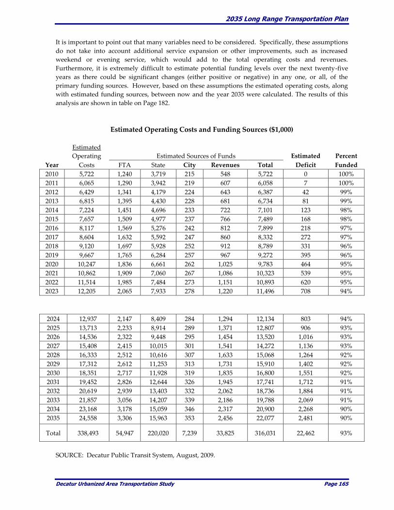
2035 Long Range Transportation Plan
Decatur Urbanized Area Transportation Study Page 165
It is important to point out that many variables need to be considered. Specifically, these assumptions
do not take into account additional service expansion or other improvements, such as increased
weekend or evening service, which would add to the total operating costs and revenues.
Furthermore, it is extremely difficult to estimate potential funding levels over the next twenty-five
years as there could be significant changes (either positive or negative) in any one, or all, of the
primary funding sources. However, based on these assumptions the estimated operating costs, along
with estimated funding sources, between now and the year 2035 were calculated. The results of this
analysis are shown in table on Page 182.
Estimated Operating Costs and Funding Sources ($1,000)
Estimated
Operating Estimated Sources of Funds Estimated Percent
Year Costs FTA State City Revenues Total Deficit Funded
2010 5,722 1,240 3,719 215 548 5,722 0 100%
2011 6,065 1,290 3,942 219 607 6,058 7 100%
2012 6,429 1,341 4,179 224 643 6,387 42 99%
2013 6,815 1,395 4,430 228 681 6,734 81 99%
2014 7,224 1,451 4,696 233 722 7,101 123 98%
2015 7,657 1,509 4,977 237 766 7,489 168 98%
2016 8,117 1,569 5,276 242 812 7,899 218 97%
2017 8,604 1,632 5,592 247 860 8,332 272 97%
2018 9,120 1,697 5,928 252 912 8,789 331 96%
2019 9,667 1,765 6,284 257 967 9,272 395 96%
2020 10,247 1,836 6,661 262 1,025 9,783 464 95%
2021 10,862 1,909 7,060 267 1,086 10,323 539 95%
2022 11,514 1,985 7,484 273 1,151 10,893 620 95%
2023 12,205 2,065 7,933 278 1,220 11,496 708 94%
2024 12,937 2,147 8,409 284 1,294 12,134 803 94%
2025 13,713 2,233 8,914 289 1,371 12,807 906 93%
2026 14,536 2,322 9,448 295 1,454 13,520 1,016 93%
2027 15,408 2,415 10,015 301 1,541 14,272 1,136 93%
2028 16,333 2,512 10,616 307 1,633 15,068 1,264 92%
2029 17,312 2,612 11,253 313 1,731 15,910 1,402 92%
2030 18,351 2,717 11,928 319 1,835 16,800 1,551 92%
2031 19,452 2,826 12,644 326 1,945 17,741 1,712 91%
2032 20,619 2,939 13,403 332 2,062 18,736 1,884 91%
2033 21,857 3,056 14,207 339 2,186 19,788 2,069 91%
2034 23,168 3,178 15,059 346 2,317 20,900 2,268 90%
2035 24,558 3,306 15,963 353 2,456 22,077 2,481 90%
Total 338,493 54,947 220,020 7,239 33,825 316,031 22,462 93%
SOURCE: Decatur Public Transit System, August, 2009.
2035 Long Range Transportation Plan
Decatur Urbanized Area Transportation Study Page 166
Based upon the analysis, it was estimated that the operating expenses over the next twenty-five years
would total over $338 million. During this same time period the potential funding sources total nearly
$316 million. This scenario would leave a total deficit of approximately $22 million over the next
twenty-five years. Again, several factors should be considered as part of this projection, such as the
number of fare increases during the twenty-five year period, other potential funding sources, and
expansion of service or the service area.
This analysis highlights the importance of securing adequate revenues and funding sources to
maintain a high level of transit operations within the MPA. Further- more, the analysis identifies other
potential concerns that need to be considered over the next twenty-five years. The potential $22
million gap between the estimated operating costs and projected funding levels could result in one or
more of the following.
Transit fares would need to be increased to generate additional funds to cover increasing
operating costs. Increasing transit fares is never a popular decision but is one that is necessary
to offset rising operating costs.
If funding levels do not increase at a higher rate than the projected levels, some elements of
the transit service may need to be eliminated or scaled back to reduce operating costs.
Without additional funding sources it would be extremely difficult to extend the hours of
transit operation to provide later service.
Without additional funding sources it would be extremely difficult to expand service beyond
current service boundaries to other areas of the MPA.
Additional funding from other communities would be necessary to provide expansion of
transit service throughout the MPA.

2035 Long Range Transportation Plan
Decatur Urbanized Area Transportation Study Page 167
Capital Improvements
The major capital improvement expense identified for the transit component of the DUATS 2035 LRTP
is the regularly scheduled replacement of transit vehicles. Over the next twenty-five years, it is
projected that approximately 39 new buses will be needed. Other planned improvements include the
replacement of two trolleys that is anticipated around the year 2016. Finally, the plan also identifies
the replacement of approximately 18 new vans between 2010 and 2035. The total estimated cost, as
shown in Table 6-5, is approximately $19.7 million.
Transit Improvement Cost
Vehicle Estimated Estimated
Type Improvement Description Cost ($1,000) Year
______________________________________________________________________
Buses 4 Replacement 35' Low Floor Buses 1,400 2010
7 Replacement 30' Low Floor Buses 2,450 2013
6 Replacement 30' Low Floor Buses 2,361 2017
5 Replacement 30' Low Floor Buses and 2,350
4 Replacement 35' Low Floor Buses 2,056 2023
7 Replacement 30' Low Floor Buses 3,702 2027
6 Replacement 30' Low Floor Buses 3,572 2031
SUBTOTAL 17,891
_____________________________________________________________________
Trolleys 2 Replacement Trolley Replica Coaches 454 2016
SUBTOTAL 454
______________________________________________________________________
Wheelchair 2 Replacement Light-Duty W/C-Lift Vans 104 2010
Lift Vans 2 Replacement Light-Duty W/C-Lift Vans 114 2013
2 Replacement Light-Duty W/C-Lift Vans 124 2016
2 Replacement Light-Duty W/C-Lift Vans 136 2019
2 Replacement Light-Duty W/C-Lift Vans 149 2022
2 Replacement Light-Duty W/C-Lift Vans 162 2025
2 Replacement Light-Duty W/C-Lift Vans 177 2028
2 Replacement Light-Duty W/C-Lift Vans 194 2031
2 Replacement Light-Duty W/C-Lift Vans 212 2034
SUBTOTAL 1,372
______________________________________________________________________
TOTAL VEHICLE IMPROVEMENT COSTS 19,717
______________________________________________________________________ SOURCE: Decatur Public Transit System, August, 2009
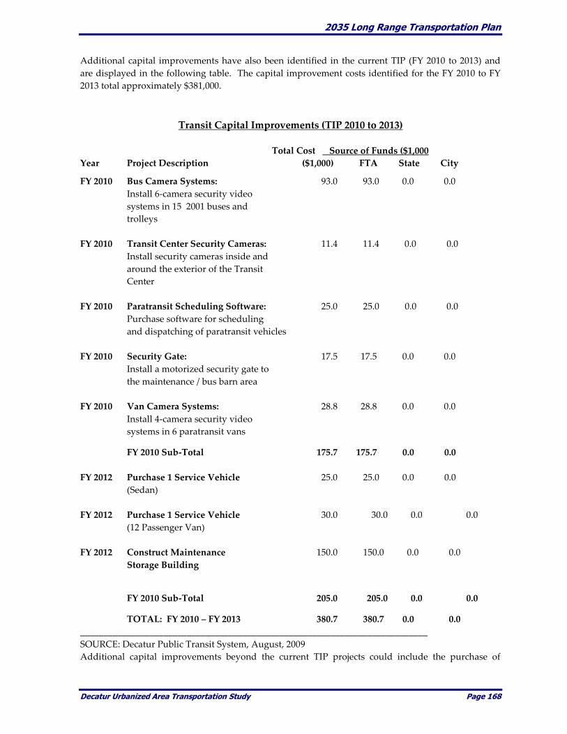
2035 Long Range Transportation Plan
Decatur Urbanized Area Transportation Study Page 168
Additional capital improvements have also been identified in the current TIP (FY 2010 to 2013) and
are displayed in the following table. The capital improvement costs identified for the FY 2010 to FY
2013 total approximately $381,000.
Transit Capital Improvements (TIP 2010 to 2013)
Total Cost Source of Funds ($1,000
Year Project Description ($1,000) FTA State City
FY 2010 Bus Camera Systems: 93.0 93.0 0.0 0.0
Install 6-camera security video
systems in 15 2001 buses and
trolleys
FY 2010 Transit Center Security Cameras: 11.4 11.4 0.0 0.0
Install security cameras inside and
around the exterior of the Transit
Center
FY 2010 Paratransit Scheduling Software: 25.0 25.0 0.0 0.0
Purchase software for scheduling
and dispatching of paratransit vehicles
FY 2010 Security Gate: 17.5 17.5 0.0 0.0
Install a motorized security gate to
the maintenance / bus barn area
FY 2010 Van Camera Systems: 28.8 28.8 0.0 0.0
Install 4-camera security video
systems in 6 paratransit vans
FY 2010 Sub-Total 175.7 175.7 0.0 0.0
FY 2012 Purchase 1 Service Vehicle 25.0 25.0 0.0 0.0
(Sedan)
FY 2012 Purchase 1 Service Vehicle 30.0 30.0 0.0 0.0
(12 Passenger Van)
FY 2012 Construct Maintenance 150.0 150.0 0.0 0.0
Storage Building
FY 2010 Sub-Total 205.0 205.0 0.0 0.0
TOTAL: FY 2010 – FY 2013 380.7 380.7 0.0 0.0
___________________________________________________________________________
SOURCE: Decatur Public Transit System, August, 2009
Additional capital improvements beyond the current TIP projects could include the purchase of

2035 Long Range Transportation Plan
Decatur Urbanized Area Transportation Study Page 169
additional transit vehicles to provide service to other areas of the DUATS MPA. Any expansion of
public transportation to new areas, outside of the current DPTS service area, would likely require
additional vehicles. Extending service would not only require the initial capital expense but as
previously mentioned would also result in an increase in operating expenses.
As no specific plans are identified to extend transit service in the near future, no capital cost estimates
beyond the current TIP are identified. Capital improvements, such as purchasing additional buses or
paratransit vans, would rely heavily on the type and amount of service that would be provided. This
would require a detailed planning study to determine the exact service needed and the capital and
operating costs associated with any proposed transit service improvement.
Transit Funding Sources The FTA administers the two primary funding programs that are applicable to the current transit
service provided by the DPTS in the DUATS MPA: Section 5307 Urbanized Area Formula program
and Section 5309 Capital Investment program. The FTA also provides the Section 5310 Elderly and
Persons with Disabilities Program and the Job Access and Reverse Commute Program that can
provide some targeted and limited funding. There are several other categories of Federal public
transportation funding that are available, such as the flexible highway programs. The State of Illinois
also provides significant
funding in the form of the Downstate Public Transportation Fund.
Illinois Downstate Public Transportation Fund The State’s Downstate Public Transportation Fund provides reimbursements to transit operators for a
percentage of their public transit operating expenses. Eligible participants are defined by the
Downstate Public Transportation Act. In 2008 the state increased its funding for transit operations
from 55% up to 65% reimbursement for eligible transit operating expenses.
Section 5307 (Urbanized Area Formula Program) Section 5307, the Urbanized Area Formula program (49 U.S.C. 5307), makes Federal resources
available to urbanized areas and to Governors for transit capital and operating assistance in urbanized
areas and for transportation related planning. An urbanized area is an incorporated area with a
population of 50,000 or more that is designated as such by the U.S. Department of Commerce, Bureau
of the Census. For urbanized areas under 200,000 in population, the Section 5307 formula
apportionments are based on population and population density. Eligible purposes for Section 5307
funds include:
Planning, Engineering design and evaluation of transit projects and other technical
transportation-related studies;
Capital investments in bus and bus-related activities such as replacement of buses, overhaul
of buses, rebuilding of buses, crime prevention and security equipment and construction of
maintenance and passenger facilities; and,
All preventive maintenance and some Americans with Disabilities Act complementary
paratransit service costs are considered capital costs.
2035 Long Range Transportation Plan
Decatur Urbanized Area Transportation Study Page 170
Section 5309 (Capital Investment Program) Section 5309, the transit capital investment program (49 U.S.C. 5309), provides capital assistance for
three primary activities:
New and replacement buses and facilities;
Modernization of existing rail systems; and,
New fixed guideway systems.
Section 5309 funds, as they relate to the DUATS MPA, are used generally for replacement of buses and
improving/maintaining existing transit facilities. Funds are allocated on a discretionary basis. Eligible
purposes for Section 5309 funds, as identified by the FTA, include:
Acquisition of buses for fleet and service expansion;
Bus maintenance and administrative facilities;
Transfer facilities;
Bus malls;
Transportation centers;
Intermodal terminals;
Park-and-ride stations;
Acquisition of replacement vehicles;
Bus rebuilds;
Bus preventive maintenance;
Passenger amenities such as passenger shelters and bus stop signs;
Accessory and miscellaneous equipment such as mobile radio units, supervisory vehicles, fare
boxes, computers, shop and garage equipment; and,
Costs incurred in arranging innovative financing for eligible projects..
Section 5303 (Metropolitan Planning)
Section 5303, Metropolitan Planning program (49 U.S.C. 5303), provides funding to support the
cooperative, continuous, and comprehensive planning program for making transportation investment
decisions in metropolitan areas. According to the FTA, State DOTs and MPOs may receive funds for
purposes that support the economic vitality of the metropolitan area, especially by enabling global
competitiveness, productivity, and efficiency; increasing the safety and security of the transportation
system for motorized and non-motorized users; increasing the accessibility and mobility options
available to people and for freight; protecting and enhancing the environment, promoting energy
conservation, and improving quality of life; enhancing the integration and connectivity of the
transportation system, across and between modes, for people and freight; promoting efficient system
management and operation; and emphasizing the preservation of the existing transportation system.
Funds are apportioned by a complex formula to States that includes consideration of each State’s
urbanized area population in proportion to the urbanized area population for the entire Nation, as
well as other factors. States can receive no less than .5 percent of the amount apportioned. These
funds, in turn, are sub-allocated by States to MPOs by a formula that considers each MPOs urbanized
area population, the individual planning needs, and a minimum distribution.
2035 Long Range Transportation Plan
Decatur Urbanized Area Transportation Study Page 171
Special Programs/Grants
New Freedom
The New Freedom formula grant program aims to provide additional tools to overcome existing
barriers facing Americans with disabilities seeking integration into the work force and full
participation in society. Lack of adequate transportation is a primary barrier to work for individuals
with disabilities. The 2000 Census showed that only 60 percent of people between the ages of 16 and
64 with disabilities are employed. The New Freedom formula grant program seeks to reduce barriers
to transportation services and expand the transportation mobility options available to people with
disabilities beyond the requirements of the Americans with Disabilities Act (ADA) of 1990.
States and public bodies are eligible to be designated recipients. Eligible sub-recipients are private
non-profit organizations, State or local governments, and operators of public transportation services
including private operators of public transportation services.
Capital and operating expenses for new public transportation services and new public transportation
alternatives beyond those required by the American with Disabilities Act of 1990 (ADA), that are
designed to assist individuals with disabilities.
Job Access and Reverse Commute Legislation The Job Access and Reverse Commute (JARC) grant program assists states and localities in developing
new or expanded transportation services that connect welfare recipients and other low-income
persons to jobs and other employment related services. Job Access projects are targeted at developing
new or expanded transportation services such as shuttles, vanpools, new bus routes, connector
services to mass transit, and guaranteed ride home programs for welfare recipients and low-income
persons. Reverse Commute projects provide transportation services to suburban employment centers
from urban, rural and other suburban locations for all populations.
Flexible Funds for Highway and Transit Flexible Funding Flexible funds are certain legislatively specified funds that may be used either for transit or highway
purposes. The idea of flexible funds is that a local area can choose to use certain Federal surface
transportation funds based on local planning priorities, not on a restrictive definition of program
eligibility. Flexible funds include FHWA STP funds and Congestion Mitigation and Air Quality
Improvement Program (CMAQ) and Federal Transit Administration (FTA) Urban Formula Funds.
FTA provides funds for transit projects. FTA funding can be used for a variety of transit
improvements such as new fixed guideway projects, bus purchases, construction and rehabilitation of
rail stations, maintenance facility construction and renovations, alternatively-fueled bus purchases,
bus transfer facilities, multimodal transportation centers, and advanced technology fare collection
systems
STP-U and STP-Rural funds provide the greatest flexibility in project funding. These funds may be
used (as capital funding) for public transportation capital improvements, car and vanpool projects,
fringe and corridor parking facilities, bicycle and pedestrian facilities, and intercity or intra-city bus
terminals and bus facilities. As funding for planning, these funds can be used for surface
transportation planning activities, wetland mitigation, transit research and development, and
environmental analysis. Other eligible projects under STP include transit safety improvements and
most transportation control measures.
The National Highway System (NHS) provides funding for a wide range of transportation activities.

2035 Long Range Transportation Plan
Decatur Urbanized Area Transportation Study Page 172
Eligible transit projects under the NHS program include fringe and corridor parking facilities, bicycle
and pedestrian facilities, carpool and vanpool projects, and public transportation facilities in NHS
corridors, where they would be cost effective and improve the level of service on a particular NHS
limited access facility.
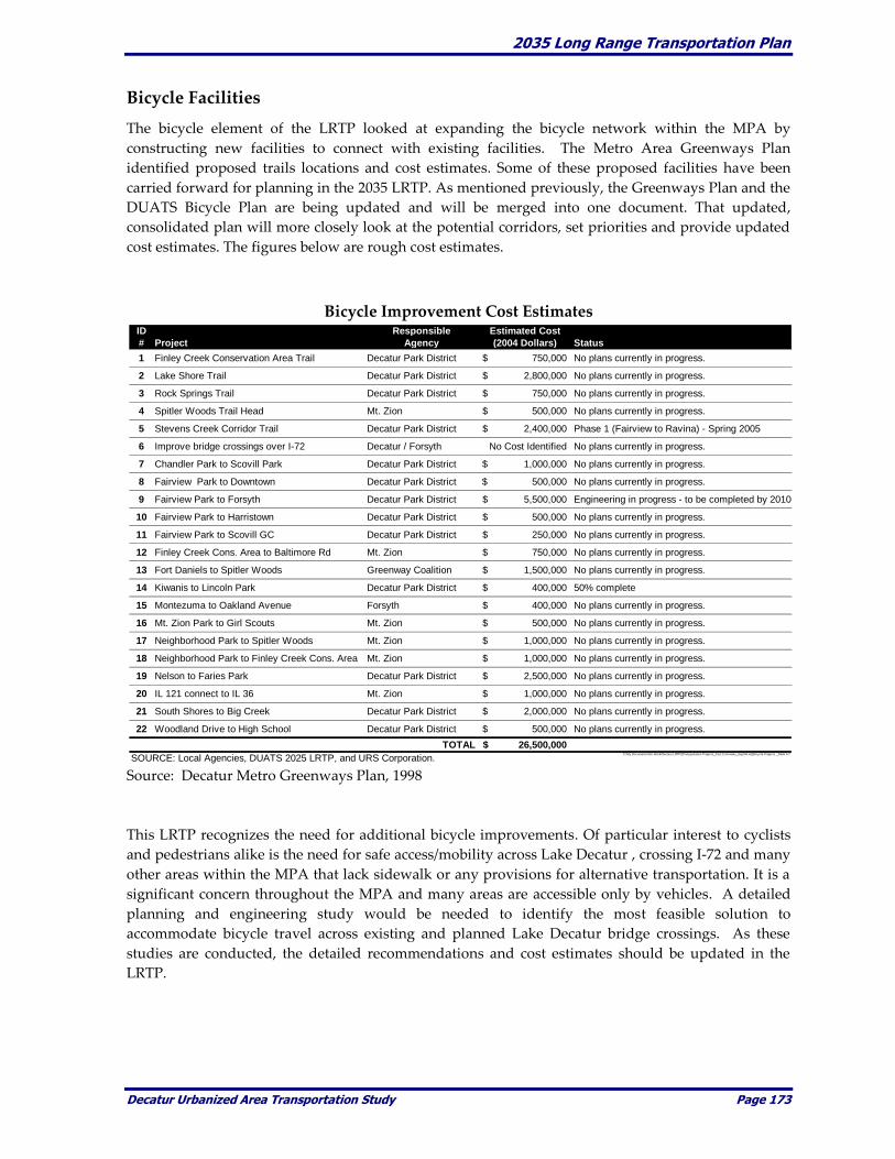
2035 Long Range Transportation Plan
Decatur Urbanized Area Transportation Study Page 173
Bicycle Facilities
The bicycle element of the LRTP looked at expanding the bicycle network within the MPA by
constructing new facilities to connect with existing facilities. The Metro Area Greenways Plan
identified proposed trails locations and cost estimates. Some of these proposed facilities have been
carried forward for planning in the 2035 LRTP. As mentioned previously, the Greenways Plan and the
DUATS Bicycle Plan are being updated and will be merged into one document. That updated,
consolidated plan will more closely look at the potential corridors, set priorities and provide updated
cost estimates. The figures below are rough cost estimates.
Bicycle Improvement Cost Estimates
Source: Decatur Metro Greenways Plan, 1998
This LRTP recognizes the need for additional bicycle improvements. Of particular interest to cyclists
and pedestrians alike is the need for safe access/mobility across Lake Decatur , crossing I-72 and many
other areas within the MPA that lack sidewalk or any provisions for alternative transportation. It is a
significant concern throughout the MPA and many areas are accessible only by vehicles. A detailed
planning and engineering study would be needed to identify the most feasible solution to
accommodate bicycle travel across existing and planned Lake Decatur bridge crossings. As these
studies are conducted, the detailed recommendations and cost estimates should be updated in the
LRTP.
ID Responsible Estimated Cost
# Project Agency (2004 Dollars) Status
1 Finley Creek Conservation Area Trail Decatur Park District 750,000$ No plans currently in progress.
2 Lake Shore Trail Decatur Park District 2,800,000$ No plans currently in progress.
3 Rock Springs Trail Decatur Park District 750,000$ No plans currently in progress.
4 Spitler Woods Trail Head Mt. Zion 500,000$ No plans currently in progress.
5 Stevens Creek Corridor Trail Decatur Park District 2,400,000$ Phase 1 (Fairview to Ravina) - Spring 2005
6 Improve bridge crossings over I-72 Decatur / Forsyth No Cost Identified No plans currently in progress.
7 Chandler Park to Scovill Park Decatur Park District 1,000,000$ No plans currently in progress.
8 Fairview Park to Downtown Decatur Park District 500,000$ No plans currently in progress.
9 Fairview Park to Forsyth Decatur Park District 5,500,000$ Engineering in progress - to be completed by 2010
10 Fairview Park to Harristown Decatur Park District 500,000$ No plans currently in progress.
11 Fairview Park to Scovill GC Decatur Park District 250,000$ No plans currently in progress.
12 Finley Creek Cons. Area to Baltimore Rd Mt. Zion 750,000$ No plans currently in progress.
13 Fort Daniels to Spitler Woods Greenway Coalition 1,500,000$ No plans currently in progress.
14 Kiwanis to Lincoln Park Decatur Park District 400,000$ 50% complete
15 Montezuma to Oakland Avenue Forsyth 400,000$ No plans currently in progress.
16 Mt. Zion Park to Girl Scouts Mt. Zion 500,000$ No plans currently in progress.
17 Neighborhood Park to Spitler Woods Mt. Zion 1,000,000$ No plans currently in progress.
18 Neighborhood Park to Finley Creek Cons. Area Mt. Zion 1,000,000$ No plans currently in progress.
19 Nelson to Faries Park Decatur Park District 2,500,000$ No plans currently in progress.
20 IL 121 connect to IL 36 Mt. Zion 1,000,000$ No plans currently in progress.
21 South Shores to Big Creek Decatur Park District 2,000,000$ No plans currently in progress.
22 Woodland Drive to High School Decatur Park District 500,000$ No plans currently in progress.
TOTAL 26,500,000$
SOURCE: Local Agencies, DUATS 2025 LRTP, and URS Corporation.C:\My Documents\Jim Work\Decatur LRTP\[Transportation Projects_Cost Estimates_Sept04.xls]Bicycle Projects _Table 6-7
2035 Long Range Transportation Plan
Decatur Urbanized Area Transportation Study Page 174
Bicycle Funding Sources
Illinois Transportation Enhancement Program (ITEP) Ten percent of the Surface Transportation Program funds are for projects that serve to enhance the
transportation system. The enhancement program allows transportation projects to include alternative
transportation modes, including bicycles. The goal of the ITEP is to allocate resources to well-planned
projects that provide and support alternate modes of transportation, enhance the transportation
system through preservation of visual and cultural resources and improve the quality of life for
members of the communities. Under ITEP, the IDOT works jointly with other state agencies, local
governments, interest groups and citizens in enhancing the transportation system and building more
livable communities.
According to IDOT, the Illinois Transportation Enhancement funds are fully programmed through
2004. Reauthorization legislation to continue Enhancement funding beyond 2004 is being drafted
nationally for consideration. For these reasons, IDOT is not accepting applications for new
transportation enhancement projects until after the reauthorization legislation is passed and the
federal funds become available. Expectations are that the enhancement program will again be funded
at or above the levels provided under TEA-21. In all likelihood, the transportation enhancement
funds will not be available until mid to late 2005. Transportation Enhancement funds are a major
funding source for bicycle projects as nearly half of its dollars in Illinois go to bicycle and pedestrian
improvements.
Illinois Bicycle Path Grant Program The Illinois Bicycle Path Grant Program was created in 1990 to financially assist eligible units of
government acquire, construct, and rehabilitate public, non-motorized bicycle paths and directly
related support facilities. Project applications are limited to land acquisition or trail development
along a single trail corridor. Bicycle routes sharing existing roadway surfaces are not eligible for
funding consideration under this program.
Agencies eligible for assistance under this program are any unit of local government with statutory
authority to provide lands for public bicycle path purposes. This includes, but is not limited to;
counties, townships, municipalities, park districts, conservation districts and forest preserve districts.
Federally funded projects only in Phase I or Phase II engineering are not eligible for Bicycle Path
funding consideration.
The Bicycle Path grant program provides up to a maximum of 50% funding assistance on approved
local project costs. The maximum grant assistance for construction projects is limited to $200,000 per
annual request. There is no maximum grant amount limit for acquisition projects other than the
established annual state appropriation level for the program.
Recreational Trails Program (RTP) The Federal RTP was created through the National Recreational Trail Fund Act (NRTFA) enacted as
part of the ISTEA and re-authorized by the TEA-21. The RTP provides funding assistance for
acquisition, development, rehabilitation and maintenance of both motorized and non-motorized
recreation trails. By law, 30% of RTP funding allocated to each state must be earmarked for motorized
trail projects, 30% for non-motorized trail projects and the remaining 40% for multi-use (diversified)
motorized and non-motorized trails or a combination of either.
2035 Long Range Transportation Plan
Decatur Urbanized Area Transportation Study Page 175
In Illinois, RTP funds are administered by the DNR in cooperation with IDOT and FHWA. The Illinois
Greenways & Trails Council serves as the official “state trails advisory board” as required by NRTFA.
Eligible applicants include federal, state and local government agencies and not-for-profit
organizations. The RTP program can provide “up to 80%” federal funding on approved projects and
requires a minimum 20% non-federal funding match.
Eligible projects include:
Trail construction and rehabilitation;
Restoration of areas adjacent to trails damaged by unauthorized trail uses;
Construction of trail-related support facilities and amenities such as trail head parking,
restrooms, rest areas, signage, etc.; and
Acquisition from willing sellers of trail corridors through easements or fee simple title.
Community Development Block Grant (CDBG) Funds CDBG funds are allocated to metropolitan areas by the Federal government on a formula basis. These
funds must be used to principally benefit low and moderate-income persons and must be an eligible
activity as defined by program regulations. Historically, these funds have been used in the MPA to
help with the replacement of sidewalks of eligible low and moderate-income neighborhoods.
Other Grants Other grants to assist in motorized recreational trails include the Local Government Snowmobile
Program, the Snowmobile Trail Establishment Fund, and the Off-Highway Vehicle (OHV) Recreation
Trails Program. Additional information on these programs is available from IDOT.
Rail Operations
The majority of rail improvements within the MPA are the responsibility of the individual rail
companies. No significant capital investments, outside the continued maintenance of at-grade rail
crossings within the MPA, have been identified as part of the this LRTP.
At this point in time there are no plans to construct any new grade-separated facilities within the
MPA. The development of an intermodal freight facility within the MPA would require detailed
planning to determine if the area could support and benefit from such a facility.
Rail Funding Sources
Funding for rail and freight facilities comes primarily from private sources. It is possible that some
economic development grants could be used to construct intermodal facilities or other projects that
would attract or create jobs. With the growing emphasis on freight movement, more attention will be
required to be paid to this transportation sector in the future.
2035 Long Range Transportation Plan
Decatur Urbanized Area Transportation Study Page 176
Aviation
The Decatur Park District identified improvement projects to be included in the 2035 LRTP. These
projects were identified in October 2009, for implementation on a schedule yet to be determined.
Land acquisition is considered an on-going process with no-time frame identified.
The improvements include a new entrance road connection, business/industrial park infrastructure,
lengthening the primary runway, new runway lighting, a second cargo apron and lengthening the
secondary runway.
Aviation Funding Sources
The Decatur Airport is one of five airports in Illinois under control of a local park district. The annual
operating expense over recent years has been between $1.0 and $1.3 million. The average capital
expenditures over the last three years run between $150,000 and $500,000, based on Decatur’s Park
District Bond Issue. IDOT and the Federal Aviation Administration (FAA) also fund some projects as
in the runway overlay project on runway 18/36.

2035 Long Range Transportation Plan
Decatur Urbanized Area Transportation Study Page 177
CHAPTER 13. RECOMMENDATIONS
This chapter summarizes the updated recommendations to the transportation improvements and
policies. The LRTP addresses all transportation modes and is intended to be a financially constrained
plan. Those projects that are deemed important, are planned for a future year, but are not fiscally
constrained are included as “Illustrative Projects” on the basis that at some point in the future these
projects may become fiscally constrained. The improvements and policies for the respective
transportation modes are described in the following sections.
Roadway
At their Joint meeting on August 19, 2009, the Technical and Policy Committees adopted an almost
completely new set of Planned and Future Projects. Those projects are depicted on the map on Page
134. These projects were not evaluated nor chosen using the travel demand forecasting model to
determine the future year impacts on the regional transportation system. As previously stated, it was
deemed unnecessary at this time. The projects were chosen based on the Capital Improvement Plans
of the several DUATS entities.
The several specific roadway improvement projects were identified as having the most benefit to
traffic operations within the MPA. This is not to suggest that the additional roadway projects, not
included in this update, do not have benefits to the area transportation system. Instead, the priority
projects chosen are those that were identified as having the greatest benefit to the regional
transportation system. More importantly, the LRTP is intended to serve as a working document that
should be reviewed annually and can be updated at any time to reflect the changing needs and
priorities of the MPA. Over the next twenty-five years many things will change which could result in
the addition, deletion, or modification of the priority improvements.
The priority improvements total an estimated $415.5 million in 2009 dollars. $238 million is proposed
for projects that can be considered new construction and $177.5 million would be focused on
maintenance of the surface transportation system. The financial assumptions and calculations show
that approximately $190.5 million, in 2009 dollars, would be available, meaning that $13 million might
be used for so called new construction. There would be an unfunded balance of projects totaling $225
million.
The SE Beltway accounts for a total estimated cost of $198 million in year 2009 dollars. This amount
includes $18 million in engineering costs. The Beltway project has a total estimated construction cost
of $180 million in 2009 dollars. The most important portion of the SE Beltway project is from Brush
College Road to U.S. Route 36 and is labeled as the first phase. The estimated cost to construct this
part of the Beltway is estimated at approximately $95 million in 2009 dollars. The remaining portion
from U.S. Route 36 to Elwin would be Phase 2 and would be constructed following the initial phase.
Phase 2 is estimated at to cost $85 million in 2009 dollars.
Under the assumed aforementioned funding scenario, if the SE Beltway and the Ash Avenue projects
were not included in the future projects list, there appears to be adequate funding to meet the priority
obligations between now and 2035.
The SE Beltway has the potential to greatly increase accessibility in the southeast sector of the MPA,
improve freight access and movement to the Airport, potentially relieve truck traffic through
Decatur’s CBD and to promote economic development throughout the MPA and region. As such, it is
recommended that the Phase 1 be given a higher relative priority than Phase 2.

2035 Long Range Transportation Plan
Decatur Urbanized Area Transportation Study Page 178
Another high profile priority project is the extension of Ash Avenue from Martin Luther King, Jr.
Drive to IL Route 48. It is intended that this extension would have an eastern limit alignment that
would involve an intersection connection with Brush College Road and/or the SE Beltway at IL Route
48. This project would open up the whole northeast area north of the between the north existing
Decatur City limits and I-72 for mixed use development.
In addition to the specific roadway improvements identified below, additional recommendations and
policies related to the transportation and roadway network are identified on the following pages. The
additional recommendations/policies highlight other activities that should be considered to help
maintain efficient and effective roadway operations throughout the MPA, meet the provisions of
SAFETEA-LU and address, at least preliminarily, the anticipated provisions in a new transportation
authorization bill. DUATS believes that this update provides ample reporting of existing conditions,
presents the 2035 conditions in a realistic manner and lists the proposed future transportation
improvements in a fiscally constrained fashion. Those projects which have been deemed important or
a priority, but are not currently constrained, are included and identified as “Illustrative Projects,”
which are may be fiscally constrained at some point in the future.
2035 Long Range Transportation Plan
Decatur Urbanized Area Transportation Study Page 179
Issue
Proposed Recommendations / Policies
1) Roadway
Improvements /
Maintenance.
Support the implementation of the recommended roadway projects
identified on the previous page.
Monitor the priority projects to determine if projects should added,
modified, or deleted.
Continue to emphasize the maintenance of the existing roadway
facilities within the MPA.
Local agencies and the DUATS technical committee should
utilize new technology, including GIS, to better monitor
facilities such as pavement condition and structural condition.
2) Truck Traffic / Freight. Better accommodate truck traffic and freight movements within the
MPA and improve access to areas outside the MPA.
Construct the SE Beltway to provide increased accessibility
within the MPA. Designate the SE Beltway as a primary truck
route and limit truck traffic in areas such as downtown
Decatur.
Support the widening of US 51, outside of the MPA, from 2-
lane to 4-lane to I-70. This improvement would increase
regional accessibility to/from the MPA and would help
support economic opportunities within the MPA.
Explore alternatives to better accommodate truck traffic along
Brush College Road and E. William Street (IL 105). Identify
potential capacity enhancements for the Brush College Road
subway (2-lane restricted area under the Norfolk and
Southern Railroad) or identify alternative truck routes to
avoid this area.
Continue the alternate route study to determine the most
appropriate route in order to eliminate through truck traffic
from Decatur’s CBD.
Study the existing truck routes in the MPA to determine if
they might be altered to reduce conflicts between traffic
modes and to improve efficiencies.

2035 Long Range Transportation Plan
Decatur Urbanized Area Transportation Study Page 180
3) Design Considerations. Support roadway design standards that strengthen the functional
classification system. Periodically review the standards to
determine those that should be eliminated, updated, or new
standards that should be added.
Arterial roadways should generally be spaced every mile. In
more densely developed areas with uses that attract a greater
number of trips (such as a CBD or large retail or employment
centers) arterials may need to be more closely spaced.
Housing density should play a key role in determining
roadway spacing. The greater the density (expressed in
dwelling units per acre) the more closely spaced streets
should be. In no case should residential blocks exceed 500
feet. The optimum spacing falls in the range of 300 feet to 400
feet. This provides a greater number of travel paths, reduces
travel speed on residential streets, and promotes pedestrian
travel and the use of transit.
As appropriate, implement traffic calming techniques to
discourage drivers from using local residential streets for cut-
through traffic. This supports the goal of maintaining a high
quality of life within the MPA.
At every opportunity, transportation improvements should be
sensitive to the existing and planned environment. Steps
should be taken to preserve features such as trees. Planning
for improvements should involve CSS and plans should
include aesthetic characteristics to make the improvements
and corridor visually pleasing. Landscaping should be an
integral part of the finished improvements.
Design of all improvement should include alternate facilities
for pedestrians and bicyclists.

2035 Long Range Transportation Plan
Decatur Urbanized Area Transportation Study Page 181
4) Capacity Concerns. When capacity deficiencies are identified, alternative solutions to
adding new capacity should be considered and evaluated prior to
new construction.
Transportation System Management (TSM) strategies should
be considered at spot locations and at intersections and along
corridors that are operating at or over-capacity. TSM
strategies could consist of adding or extending turn-lanes
and/or improving/upgrading traffic control devices to
improve traffic flow.
Intelligent Transportation System (ITS) strategies should be
considered along identified corridors. Traffic signal
optimization and/or signal interconnects often reduce
intersection delays and ultimately reduce corridor or system
wide delays.
Access management techniques should be explored to
improve traffic flow along identified corridors. Access
management should consist of closing or consolidating access
points to promote a high level of traffic flow ultimately
helping to preserve traffic capacity and improve safety.
Potential improvements to parallel routes may reduce travel
demand along congested corridors and could save potentially
expensive capacity improvements. Such improvements should
be considered early in the study phase of any proposed
transportation improvement project.
When demand exceeds capacity, and mitigation measures are
determined to be unsuccessful, new capacity should be evaluated
and implemented to maintain a high level of mobility within the
MPA. In these cases, it is important to consider the regional
impacts of adding new capacity such as the effects new capacity
may have on nearby existing roadways, neighborhoods, schools,
and businesses.
Find an appropriate modeling tool to help evaluate the
regional impacts of potential any transportation
improvements.
Travel Demand Management (TDM) programs should be
implemented to promote efficient transportation within the MPA.
A TDM program should be coordinated with other transportation
modes including transit operations.

2035 Long Range Transportation Plan
Decatur Urbanized Area Transportation Study Page 182
5) Safety. Identify and implement appropriate Intelligent Transportation System
(ITS) applications within the MPA to maintain or enhance travel
safety.
Identify priority corridors for implementation of signal
preemption that gives priority to emergency vehicles.
Identify potential technical improvements at at-grade rail
crossings to ensure a high level of traffic, pedestrian, and
bicycle safety.
Access management techniques should be explored as a possible
solution to improve traffic safety. Access management could
consist of closing existing access points, consolidating access
points, and implementing right-in, right-out access points to
maintain a high level of traffic safety along major corridors.
2035 Long Range Transportation Plan
Decatur Urbanized Area Transportation Study Page 183
Transit Operations
Transit is a critical component of any transportation system. It provides mobility to captive as well as
choice riders and connects many individuals to jobs, schools, community centers/resources, and daily
shopping activities. As such, it is important that the DUATS support the continued development of
the DPTS services and encourage the expansion of public transportation beyond current DPTS service
area boundaries.
Transit service demand and ridership levels do not currently warrant widespread DPTS
improvements or service expansion. This is supported by the DPTS Planning Study that concluded
service expansion might not be warranted for another ten years. However, it is still important to
identify potential future year transit needs and potential improvements that could be needed over the
next twenty-five years.
The DPTS Planning Study identified four goals for transit service in Decatur7. The goals included:
1. Ensure reliable and affordable public transportation to citizens of Decatur.
2. Provide efficient service.
3. Provide service plan to meet future demand.
4. Ensure best use of available resources.
In support and expansion of these goals the following recommendations and policies are proposed for
transit operations within the MPA. The proposed recommendations and policies are summarized in
the following table.
_________________________
7 Decatur Public Transit System Planning Study, pages 69 and 70, Final Report – September, 2001.
2035 Long Range Transportation Plan
Decatur Urbanized Area Transportation Study Page 184
Proposed Transit / Paratransit Recommendations / Policies
1) Administration and Funding.
a) Create an inter-governmental partnership or regional transit board needed to initiate transit
service in areas beyond DPTS service boundaries to key activity centers throughout the
DUATS MPA.
Encourage participation of surrounding communities in the transit planning process.
Explore the potential for enacting a regional funding mechanism for public
transportation. Financial support from surrounding com-munities is critical to initiate
transit service throughout the MPA.
b) Support increased state and federal funding for transit/paratransit services within the
DUATS MPA.
c) Support innovative partnerships between highway and transit agencies to broaden the
range of eligible activities their funds can support.
d) Continue to explore opportunities for funding/grants from programs such as welfare
reform and Medicaid/ Medicare.
2) Service Enhancements.
e) Provide an expanded level of transit/paratransit services to meet existing and future year
community transportation needs.
Explore opportunities to extend appropriate transit service (i.e., fixed route service,
paratransit/dial-a-ride services, flexible routes, community circulators, vanpools,
and/or carpools) to adjacent communities outside the City of Decatur, including
Forsyth and Mt. Zion with potential service also to Harristown and Long Creek.
f) Extend service hours to meet the needs of employees and patrons of major retail,
commercial, and/or entertainment centers.
Implement extended evening and weekend fixed-route bus service as ridership
demands warrant and funding becomes available.
Explore opportunities to implement night service hours using demand responsive
vehicles, including subsidized taxi and DPTS vans.
g) Maintain and enhance service standards for routing, on-time performance, route
productivity, frequency of operation, special populations’ needs and other standards to
ensure the provision of quality services.
Automate performance data collection systems, (e.g. using automatic vehicle location
systems and automatic passenger counters) to support and improve planning and
management analyses.
h) Acquire vans and develop a marketing program to create vanpool/carpool programs in the
DUATS MPA and surrounding area, as demand warrants.
2035 Long Range Transportation Plan
Decatur Urbanized Area Transportation Study Page 185
Target large employers with employees that arrive and depart from work at the same
time such as ADM, Caterpillar, and A.E. Staley.
3) Land Use and Development Considerations.
i) Actively promote and adopt design standards, polices, and principles, including Transit
Oriented Development (TOD), throughout the MPA.
Require all new development, especially within ¼ mile walking distance of bus
routes, to provide sidewalks and curb cuts that comply with ADA standards and
requirements.
Support the repair and upkeep of existing sidewalks to provide better connections to
transit facilities.
Provide safe and comfortable waiting areas at bus stops, including such elements as
shelters, benches, bike racks, and curb ramps. Provide communication elements such
as improved signage and enlarged schedules at major transit stops throughout the
MPA.
j) Encourage local agencies to include public transportation needs in their review of major
commercial and residential developments to ensure transit/
paratransit needs are sufficiently addressed. Such review will help to promote transit friendly
design and encourage transit usage throughout the MPA.
k) Monitor the progress and implementation of the proposed SE Beltway to determine the
appropriate type and level of transit service needed to meet
the transportation needs along this corridor.
Focus on connecting the MPA residents to new employment opportunities created by
the construction of the SE Beltway.
4) Vehicle Maintenance and Expansion.
l) Continue scheduled vehicle replacements in order to maintain a modern transit/paratransit
fleet in good working condition. Replace buses and vans whose design life has expired as
soon as funding becomes available.
m) Implement a bus fleet expansion plan to meet the increased levels of geographic coverage
and service frequency. Begin identifying potential expansion plans now so barriers to new
service implementation can be identified and addressed.
5) Safety.
n) Identify improvements, including the use of new technology, to enhance passenger safety
on buses and at the Transit Center.
Install on-board video equipment on all new (replacement) buses to provide an
increased level of security.
Install on-board video equipment on existing buses and at the Transit Center to
provide an increased level of security. Implement this improvement when funding is
available.
2035 Long Range Transportation Plan
Decatur Urbanized Area Transportation Study Page 186
Consider the implementation of Global Positioning Systems (GPS) to help monitor
transit and paratransit vehicle locations. Specific route location can help in the event
of an emergency and can also help improve transit route efficiency. Implement this
improvement when funding is available.
6) Intermodal Connections.
o) Continue to work to establish linkages between DPTS and taxi services and intercity motor
coach services by offering accommodations and providing connections at the downtown
Transit Center.
p) Support projects that encourage the integration of transit and bicycles.
When demand warrants and as funding permits, implement a bicycle on buses
program to encourage increased accessibility for bicyclists throughout the DUATS
MPA. Initial implementation of a bicycle on buses program should focus specifically
on routes serving Millikin University, Richland Community College, and Hickory
Point Mall.
Improve bicycle connections to/from the DPTS Transit Center and monitor bicycle
parking needs. Increase bicycle parking at the Transit Center as bicycle parking
demand warrants.
q) Integrate community transit/paratransit centers with existing or planned activity centers
(shopping centers, office districts, etc.) as focal points where public transportation services
converge and users can transfer among the various transit services. The characteristics of each
center should be tailored to reflect the needs of the specific communities in which they are
located.

2035 Long Range Transportation Plan
Decatur Urbanized Area Transportation Study Page 187
Bicycle/Pedestrian Facilities
Existing bicycle travel within the DUATS relies primarily on on-road bikeways and is supplemented
with bike trails through and/or adjacent to parks and green spaces. This LRTP update includes a
number of proposed bicycle routes and identifies a number of corridors that should be considered for
future year bicycle facilities including multi-use trails. These recommendations do not necessarily
mean that the list will be the same in the soon to be completed the Decatur Metro Area Greenway
Plan. Rather these corridors were identified to serve the broadest population bases, the most
generators and attractors and to provide the foundation for future corridor improvements. The areas
identified include the central business district, regional shopping centers, parks and educational
campuses. The LRTP is intended to support the continuing development of the previously identified
bicycle corridors within the MPA and the update to the Decatur Metro Area Greenway Plan.
In addition to the bicycle facilities previously identified, this LRTP identifies additional priority
corridors, spot location improvements, and roadways most suitable for on-road bicycle travel. These
additional corridors and improvements are intended to expand the existing and planned bicycle
network beyond existing limits to better serve the entire MPA.
The bicycle plan focuses on the potential to expand the bicycle or multi-use trails beyond the current
and or previously identified limits. Over the next twenty-five years opportunities will arise to
incorporate bicycle travel into planned roadway projects. Specifically, the SE Beltway is a project that
should accommodate bicycle travel, in particular along Reas Bridge Road and the Lake Decatur
crossing. The close proximity of this bridge crossing to the Richland Community College makes this
an ideal location for a bicycle facility. Bicycle accommodations along the southern alignment of the SE
Beltway (along CH 30) are being considered. The potential improvements should strongly consider
the construction of bicycle and pedestrian underpasses and/or overpasses to help provide mobility in
the area.
A list of corridors and potential improvements are displayed on the following map. The table that
follows summarizes the proposed bicycle and/or pedestrian recommendations and policies for
application within the MPA.

2035 Long Range Transportation Plan
Decatur Urbanized Area Transportation Study Page 188
Proposed Bicycle/Pedestrian Recommendations / Policies
Issue
Proposed Recommendations / Policies
1) Regional Bicycle
Planning.
Continue proactive regional bicycle planning to coordinate
development of a bicycle network that serves all areas of the MPA
and connects to statewide bicycle facilities beyond the MPA
boundaries.
Complete the update of the Greenways Plan and continually
identify weaknesses and identify critical linkages to public
facilities, schools, recreational areas, retail and employments
centers and the Transit Center.
Identify and preserve potential rights-of-way that could be
used to develop bicycle/pedestrian facilities. Specifically,
abandoned rail corridors should be identified and preserved
as potential linkages to the existing and planned DUATS
bicycle network.
Early in the planning stage of potential improvements,
provisions for pedestrians and cyclists should be strongly
considered.
Explore opportunities to expand the DUATS bicycle network
beyond the MPA boundaries to connect to Statewide facilities.
Specifically, support the development of a bicycle trail along
the IL 48 corridor, through Oreana, to connect to the
Heartland Pathways North and South trails as well as the
Clinton Lake area.
2) Lake Decatur Crossings. Explore opportunities to improve and accommodate bicycle and
pedestrian travel across Lake Decatur. Design and construct
bicycle/pedestrian facilities as part of any new Lake Decatur
bridge crossings.
The construction of a proposed new Reas Bridge Road
crossing, as part of the SE Beltway project, should be designed
and constructed to accommodate bicycles and pedestrians.
Such a connection should tie into the Richland Community
College, which is located in close proximity to the proposed
SE Beltway.
Explore opportunities to modify existing bridge crossings, to
better accommodate bicycle and pedestrian travel.
2035 Long Range Transportation Plan
Decatur Urbanized Area Transportation Study Page 189
3) Safe Routes to Schools. Prioritize bicycle and pedestrian improvements along corridors
connecting to schools within the MPA.
Inventory existing bicycles/pedestrian facilities by identifying
condition of sidewalks, crosswalks, presence of traffic control
devices, traffic volumes, posted speed limits, and observed
speed limits. Identify appropriate routes for bicycle and
pedestrian travel.
Continue to pursue Safe Routes to School awards throughout
the MPA.
4) Land Use and Design
Considerations.
Local agencies should adopt policies that emphasize and promote
bicycle/pedestrian travel.
Amend, or adopt, building codes and development standards
to emphasize bicycle/pedestrian travel. Building codes could
be amended to require bicycle parking/racks as part of the
building design or site plans. Terminal facilities to make
riding more attractive should also be encouraged.
Apply Context Sensitive Solutions (CSS) as appropriate to
help support pedestrian and bicycle travel. Specifically
address pedestrian and bicycle travel as part of any roadway
improvement.
Adopt aggressive street repair policies that help support
bicycle and pedestrian travel.
Designate and post bicycle route signs to increase awareness
of motorists to share the roadway with bicyclists.
Encourage the integration of land uses and mixed-use
development. This type of development supports pedestrian and
bicycle travel and would improve connections to transit stops.
Incorporate bicycle facilities in the design and construction of
major roadway improvements throughout the MPA.
Accommodate bicycles specifically in the construction of the SE
Beltway.
Accommodate bicycle travel along the SE Beltway. Construct
an underpass/overpass to facility north-south bicycle travel
across CH 30.
2035 Long Range Transportation Plan
Decatur Urbanized Area Transportation Study Page 190
5) Intermodal Connections. Support projects that encourage bicycle connections to DPTS
services throughout the MPA.
Implement a bicycle on buses program to encourage increased
accessibility for bicyclists throughout the MPA. Begin by
providing bicycle on buses specifically on routes serving
Millikin University, Richland Community College, and
Hickory Point Mall.
Improve bicycle connections to/from the DPTS Transit Center
and monitor bicycle parking needs. Increase bicycle parking
at the Transit Center as bicycle parking demand warrants.
Bicycle on buses program can address Lake Decatur crossings
and bicycle travel in the downtown area while more
permanent solutions can be identified and implemented.

2035 Long Range Transportation Plan
Decatur Urbanized Area Transportation Study Page 191
Rail Operations
Rail improvements are generally the responsibility of the individual rail companies that operate the
respective rail lines through the MPA. Rail operations, as they relate to roadway network, generally
focus on the maintenance of existing at-grade rail crossings. In some cases a particular at-grade rail
crossing may warrant improved traffic control devices or possibly a grade separated facility.
Table 7-5 summarizes the proposed rail recommendations and policies for consideration within the
MPA.
Proposed Rail Recommendations / Policies
Issue
Proposed Recommendations / Policies
1) At-Grade Crossings. Monitor at-grade rail crossings to provide a high level of safety
and mobility for motorists, bicyclists and pedestrians. Identify
high priority crossings that could be considered for improved
traffic control devices and potential grade separated facilities.
Identify transit routes and at-grade crossings to determine the
potential travel delays resulting from at-grade rail crossings.
Continue routine maintenance and upkeep of the existing rail
infrastructure.
Create an inter-jurisdictional committee of local government,
railroads and other stakeholders to explore the potential for
intermodal connections, increases in freight efficiencies, possible
trans-load operations, possible at grade crossing closures and
other improvements which would increase the effectiveness and
importance of rail service in the MPA and in the region.
2) Intermodal
Connections.
Promote the Decatur area as a regional freight distribution center
by enhancing existing and constructing new facilities using
public-private development.
Promote the expanded use of the Decatur Airport and
industrial park to serve regional and national freight/cargo
movements. Promote the construction of a rail spur serving
the industrial park.
Explore the possibility of a container handling facility within
the MPA to remain competitive in freight movement. A
Container On Flat Car/Trailer On Flat Car (COFC/TOFC)
facility would support economic development within the
MPA.
Identify and preserve abandoned rail corridors that could be used
for potential bicycle and/or multi-use trails. Keep close
communication with the rail companies to identify plans to
abandon rail lines within the MPA.

2035 Long Range Transportation Plan
Decatur Urbanized Area Transportation Study Page 192
Airport Operations
Continued investment in the Decatur Airport is necessary to maintain and enhance its position as a
passenger facility and airfreight hub of regional significance. The Plan recommends the following
actions to improve the position of the MPA as a regional air transportation center. Table 7-6
summarizes the proposed recommendations and policies.
Proposed Aviation Recommendations / Policies
Issue
Proposed Recommendations / Policies
1) Accessibility. Provide direct access between the airport and I-72 and or other
major arterials.
Improve truck access to/from the airport to encourage and
enhance freight movement within and beyond the MPA.
Coordinate the alignment of the SE Beltway with runway
extension plans and provide access to the airport via IL 105
and US Route 36
Construct the planned roadway improvements along US 36/IL
121 and Twin Bridge Road.
2) Airport Operations. Extend the primary runway to 12,000 feet to accommodate
larger aircraft, especially cargo aircraft.
Extend the secondary runway to 8,500 feet.
Discourage additional residential development around the
airport through zoning changes, especially on the north side of
the airport where noise levels are likely to be greatest and
potential exists for more noise-compatible land uses, such as
light industry and air freight operations.
Develop the north business park and passenger terminal,
including an entrance from IL 105.
3) Service Providers. Obtain a second air service provider.
Research the potential for International Charter service.
4) Intermodal
Connections.
Develop the industrial/business park and promote it as an
intermodal freight transportation hub with connections to air, rail,
and truck modes.