Embed Size (px)
Citation preview
Long-range Forecasting of Climate and Water Resources in the Pacific Northwest , October 2001, Kelso, WA
Tracking an Uncertain Climatefor Water Supply
Phillip Pasteris
Natural Resources Conservation Service
National Water and Climate Center
Portland, Oregonwww.wcc.nrcs.usda.gov

Long-range Forecasting of Climate and Water Resources in the Pacific Northwest , October 2001, Kelso, WA
WY-2001 - One for the Books!
• Lowest Columbia streamflow since 1977
• Lowest snowpacks since 1977
• Record peak power prices
• Record drought in many areas
• Significant forest fires in CA, WA, MT
Long-range Forecasting of Climate and Water Resources in the Pacific Northwest , October 2001, Kelso, WA
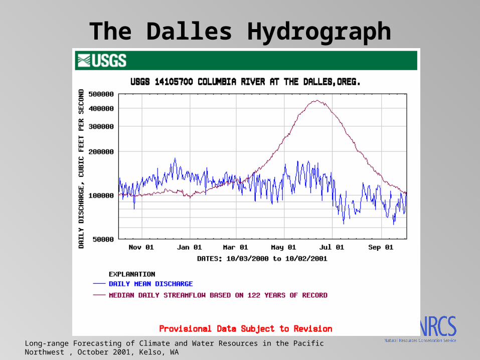
The Dalles Hydrograph

Long-range Forecasting of Climate and Water Resources in the Pacific Northwest , October 2001, Kelso, WA
Columbia Snowpack
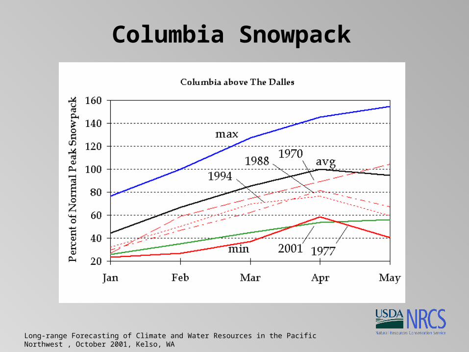
Long-range Forecasting of Climate and Water Resources in the Pacific Northwest , October 2001, Kelso, WA
Columbia Snowpack

Long-range Forecasting of Climate and Water Resources in the Pacific Northwest , October 2001, Kelso, WA
Record Drought

Long-range Forecasting of Climate and Water Resources in the Pacific Northwest , October 2001, Kelso, WA
WY-2002 - Uncertainty
• Summary provided by George Taylor, Oregon State Climatologist - www.ocs.orst.edu
• National Centers for Environmental Prediction (NCEP) coupled ocean/atmosphere model shows a weak El Nino developing in the next six months.

Long-range Forecasting of Climate and Water Resources in the Pacific Northwest , October 2001, Kelso, WA
WY-2002 - Uncertainty
• The Scripps / Max Planck Institute (MPI) hybrid coupled model include a moderate El Nino developing this fall, followed by a return to near-normal conditions in mid-winter.

Long-range Forecasting of Climate and Water Resources in the Pacific Northwest , October 2001, Kelso, WA
WY-2002 - Uncertainty
• The Climate Diagnostics Center (CDC) predictive model takes a contrary viewpoint, indicating the development of much stronger La Nina conditions in the next several months, continuing throughout the winter.
Long-range Forecasting of Climate and Water Resources in the Pacific Northwest , October 2001, Kelso, WA
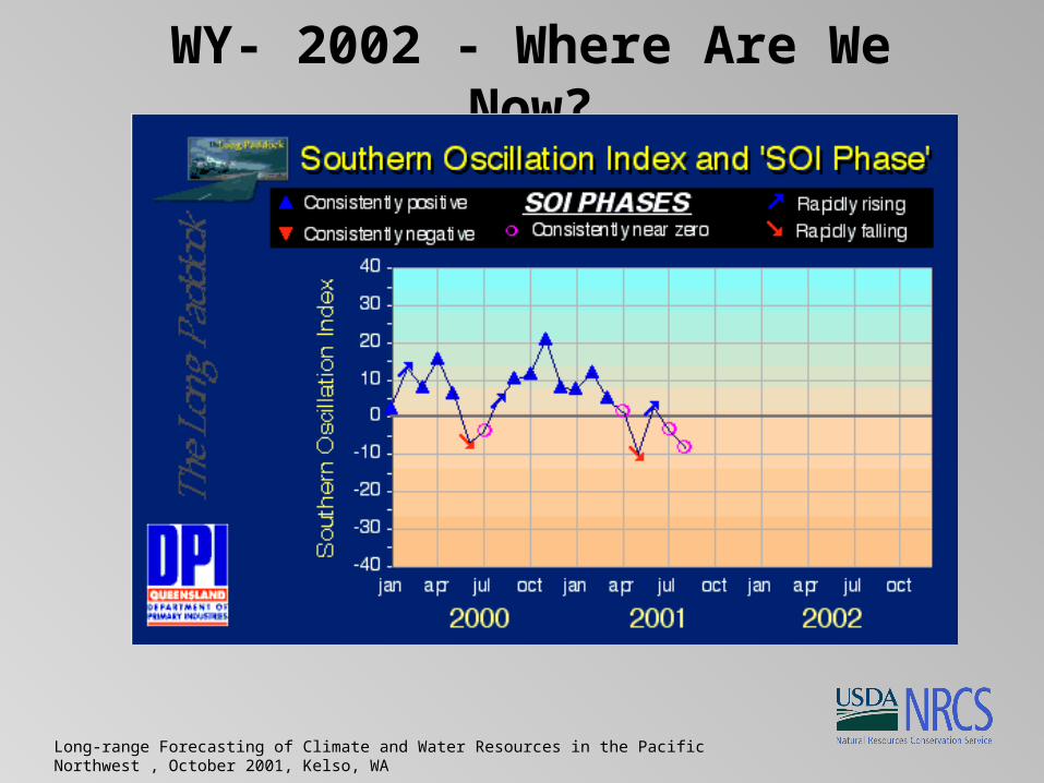
WY- 2002 - Where Are We Now?

Long-range Forecasting of Climate and Water Resources in the Pacific Northwest , October 2001, Kelso, WA
WY- 2002 - Tracking Uncertainty
• Real-time climate data from SNOTEL
• Real-time climate data from BC network
• NWS COOP climate data through UCAN
• Streamflow from the USGS
• Reservoir data from operators
Long-range Forecasting of Climate and Water Resources in the Pacific Northwest , October 2001, Kelso, WA
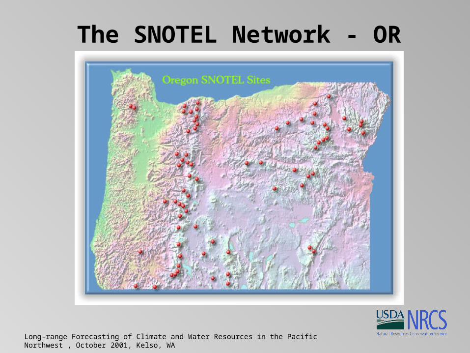
The SNOTEL Network - OR
Long-range Forecasting of Climate and Water Resources in the Pacific Northwest , October 2001, Kelso, WA
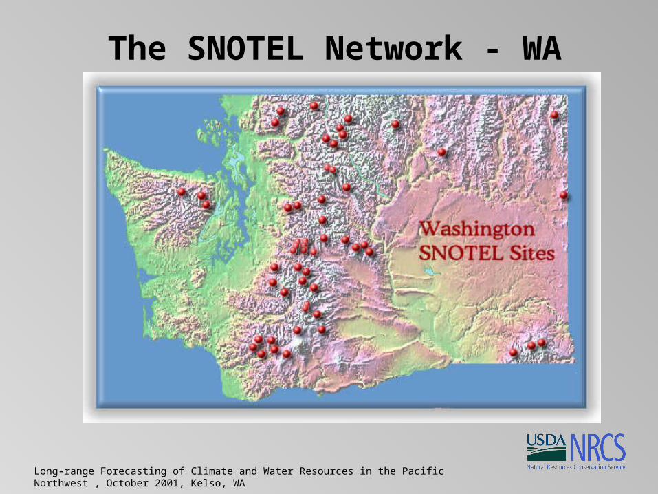
The SNOTEL Network - WA
Long-range Forecasting of Climate and Water Resources in the Pacific Northwest , October 2001, Kelso, WA
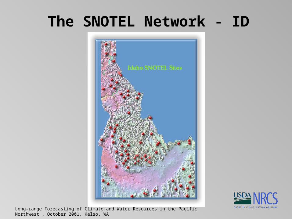
The SNOTEL Network - ID

Long-range Forecasting of Climate and Water Resources in the Pacific Northwest , October 2001, Kelso, WA
The SNOTEL Network - MT

Long-range Forecasting of Climate and Water Resources in the Pacific Northwest , October 2001, Kelso, WA
Snow Network in BC
http://www.elp.gov.bc.ca/rib/wat/rfc/river_forecast/spdcolumbia.html
Long-range Forecasting of Climate and Water Resources in the Pacific Northwest , October 2001, Kelso, WA
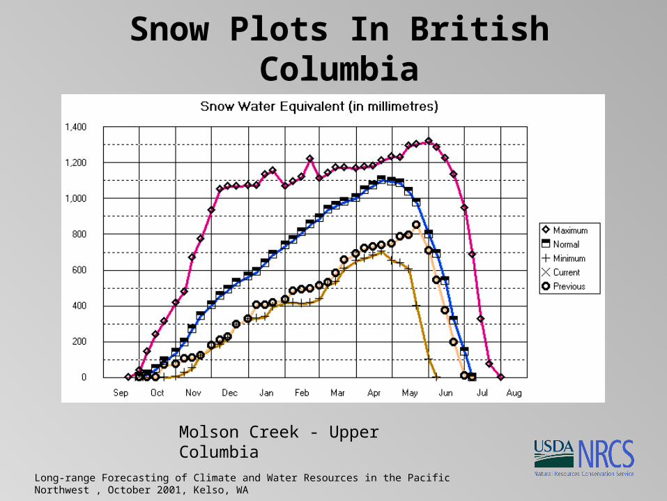
Snow Plots In British Columbia
Molson Creek - Upper Columbia

Long-range Forecasting of Climate and Water Resources in the Pacific Northwest , October 2001, Kelso, WA
Snow Plots In British Columbia
East Creek - W. Kootenay R.

Long-range Forecasting of Climate and Water Resources in the Pacific Northwest , October 2001, Kelso, WA
Snow Plots In British Columbia
Morrissey Ridge - E. Kootenay R.
Long-range Forecasting of Climate and Water Resources in the Pacific Northwest , October 2001, Kelso, WA
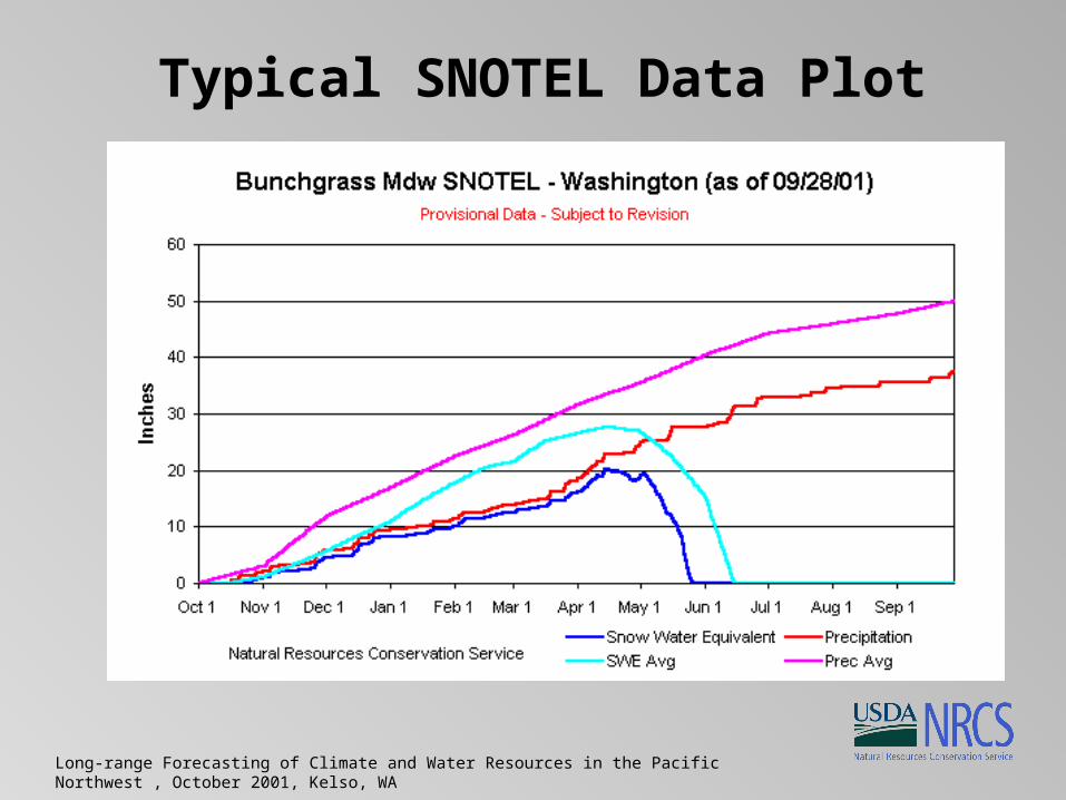
Typical SNOTEL Data Plot
Long-range Forecasting of Climate and Water Resources in the Pacific Northwest , October 2001, Kelso, WA
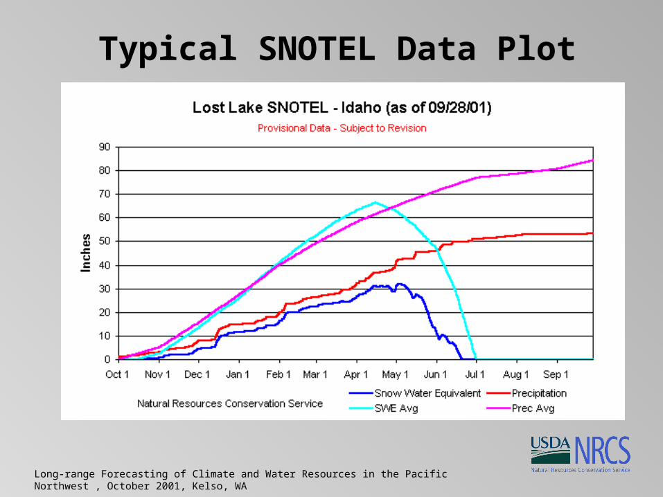
Typical SNOTEL Data Plot

Long-range Forecasting of Climate and Water Resources in the Pacific Northwest , October 2001, Kelso, WA
Typical SNOTEL Data Plot

Long-range Forecasting of Climate and Water Resources in the Pacific Northwest , October 2001, Kelso, WA
Typical SNOTEL Data Plot
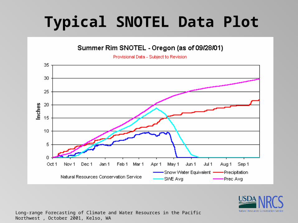
Long-range Forecasting of Climate and Water Resources in the Pacific Northwest , October 2001, Kelso, WA
Typical SNOTEL Data Plot

Long-range Forecasting of Climate and Water Resources in the Pacific Northwest , October 2001, Kelso, WA
Sub-Monthly Water Supply Forecasts
• Production of sub-monthly water supply forecasts (WSFs) is driven by user needs for more frequent assessments of water supply availability based on real-time SNOTEL information.
• Users include NRCS Water Supply Specialists; private, state, and federal reservoir owners/operators; dam safety engineers and hydrologists; Montana Fish Wildlife and Parks; Montana Power; irrigation companies; and NRCS field offices that distribute our streamflow forecasts to local irrigators, reservoir operators, and conservation district boards.
Long-range Forecasting of Climate and Water Resources in the Pacific Northwest , October 2001, Kelso, WA
Sub-Monthly Water Supply Forecasts
• The concept is to “capture the trend” using daily SNOTEL data and provide users with more frequent forecasts that reduce risk.
• Because the WSF procedures selected for this process primarily use SNOTEL data, we can use the current SNOTEL observations and project forward to the 1st of the month.
• The only "unknown" in these procedures is the next month's SNOTEL snow water equivalent value; the only other data in these procedures (until June 1) is fall precipitation, which is already known.
Long-range Forecasting of Climate and Water Resources in the Pacific Northwest , October 2001, Kelso, WA
Sub-Monthly Water Supply Forecasts
• Flat-line scenario:
• We can simply take the value from SNOTEL today and use it as is, thus assuming no additional accumulation for the rest of the month.
Long-range Forecasting of Climate and Water Resources in the Pacific Northwest , October 2001, Kelso, WA
Sub-Monthly Water Supply Forecasts
• Add/subtract some portion of a normal (average) increment:
• If we think the precipitation during the remaining period of the month is going to be below normal, then we could add, say, 75% of a normal increase (prorated for the days left until the first of the month) to the current observed value.
• Likewise, we could add, say, 125% of the normal increase if we saw that the weather forecasts called for major storms in the coming days or weeks.
Long-range Forecasting of Climate and Water Resources in the Pacific Northwest , October 2001, Kelso, WA
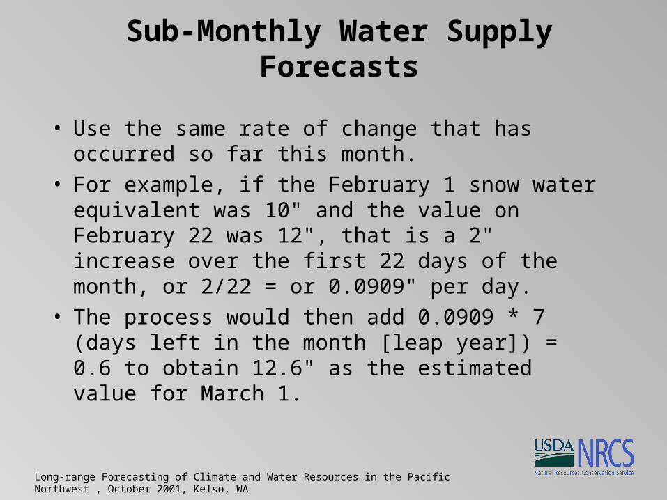
Sub-Monthly Water Supply Forecasts
• Use the same rate of change that has occurred so far this month.
• For example, if the February 1 snow water equivalent was 10" and the value on February 22 was 12", that is a 2" increase over the first 22 days of the month, or 2/22 = or 0.0909" per day.
• The process would then add 0.0909 * 7 (days left in the month [leap year]) = 0.6 to obtain 12.6" as the estimated value for March 1.

Long-range Forecasting of Climate and Water Resources in the Pacific Northwest , October 2001, Kelso, WA
Preliminary Results
• Montana responses were very favorable.• Recognized the deteriorating snowpack
conditions.• Captured the trend on a weekly basis.• Provided opportunities to ingest late season
snowfalls and reduce hope for drought reduction.
• Further analysis underway.
Long-range Forecasting of Climate and Water Resources in the Pacific Northwest , October 2001, Kelso, WA
In Summary
• Climate trends and variability are something we need to learn to live with.
• Using climate networks, like SNOTEL, on a daily basis helps all resource managers and the public cope.
• “The future ain’t what it used to be.” - Yogi Berra