Embed Size (px)
Citation preview
Transport for London.
London Loop. Section 8 of 24.
Bourne Hall Park, Ewell to Kingston Bridge.
Section distance: 7.3 miles (12 kilometres).
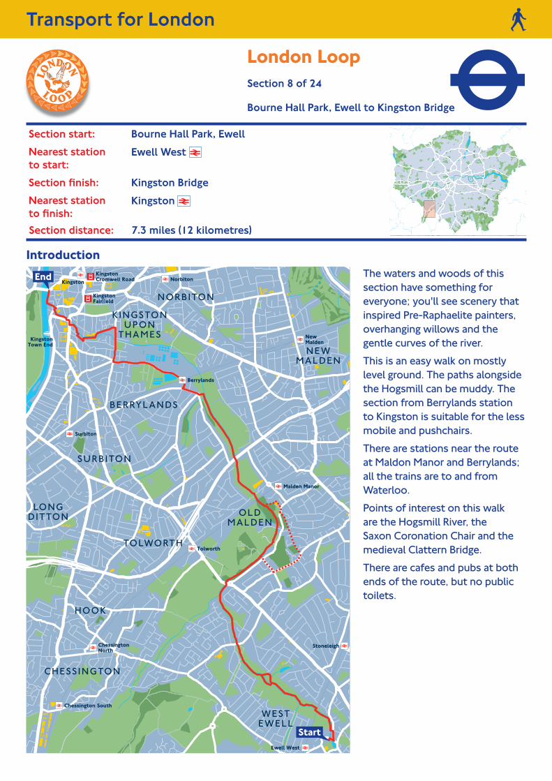
Introduction. The waters and woods of this section have something for everyone; you'll see scenery that inspired Pre-Raphaelite painters, overhanging willows and the gentle curves of the river.
This is an easy walk on mostly level ground. The paths alongside the Hogsmill can be muddy. The section from Berrylands station to Kingston is suitable for the less mobile and pushchairs.
There are stations near the route at Maldon Manor and Berrylands; all the trains are to and from Waterloo.
Points of interest on this walk are the Hogsmill River, the Saxon Coronation Chair and the medieval Clattern Bridge.
There are cafes and pubs at both ends of the route, but no public toilets.
Section start: Bourne Hall Park, Ewell.
Nearest station to start:
Ewell West
Section finish: Kingston Bridge.
Nearest station to finish:
Kingston
3
2
SO
UT
H LA
NE
K I N G S T O N R O A D
T H E T F O R D R D
MA
LDE
N R
OA
D
RA
EB
UR
N A
VE
NU
E
RA
EB
UR
N A
VE
NU
E
RA
EB
UR
N A
VE
NU
E
WA R R E N D R N O R T H
E L GA R A
VENUE
ELMB
R IDGE AV ENU
E
MA
LDEN WAY
( K I N G S T O N BY PA S S )
MA
NO
R DR IVE N
ORTH
MANOR DR N
ORTH
S O UTH LA NE
M A L D E N WAY
A M B E R W O O D R I S E
C H U R C H R O A D
MA
LDE
N R
OA
D
W O R C E S T E R PA R K R
O A D
G R A F T O N R O A D
K INGSTON ROAD
OLD
MA
LDEN
LA
NE
S A L I S B U R Y R O A D
T HE AV E N U E
RUX L EY LA
NE
WES
TBU
RY ROA
D
JUB I LE E W
AY
K ING
STON
R O A D
CROMW
EL L ROAD G R A F T O N R O A D
TolworthTower
Epsom & EwellHigh School
Surbiton TownSports Club
SurbitonRaceway
Richard ChallonerSchool
TheRiverClub
St. John theBaptist Church
Wandgas Sports& Social Club
St. Clement’sRC Church
OldMaldenLibrary
UnitedReformedChurch
New MaldenLibrary
The HolyCross School
MaldenCentre
Auriol Park
HogsmillOpen Space
HogsmillPublicOpen Space
Berrylands
Malden Manor
Tolworth
Hogsmill River
Hogsm
ill River
Bonesgate Stream
OOLDDDDDMA DENLDENENENEN
Con
tinu
es
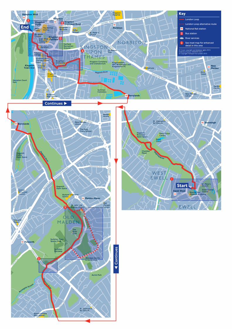
Continues on next page
Continues
Directions.
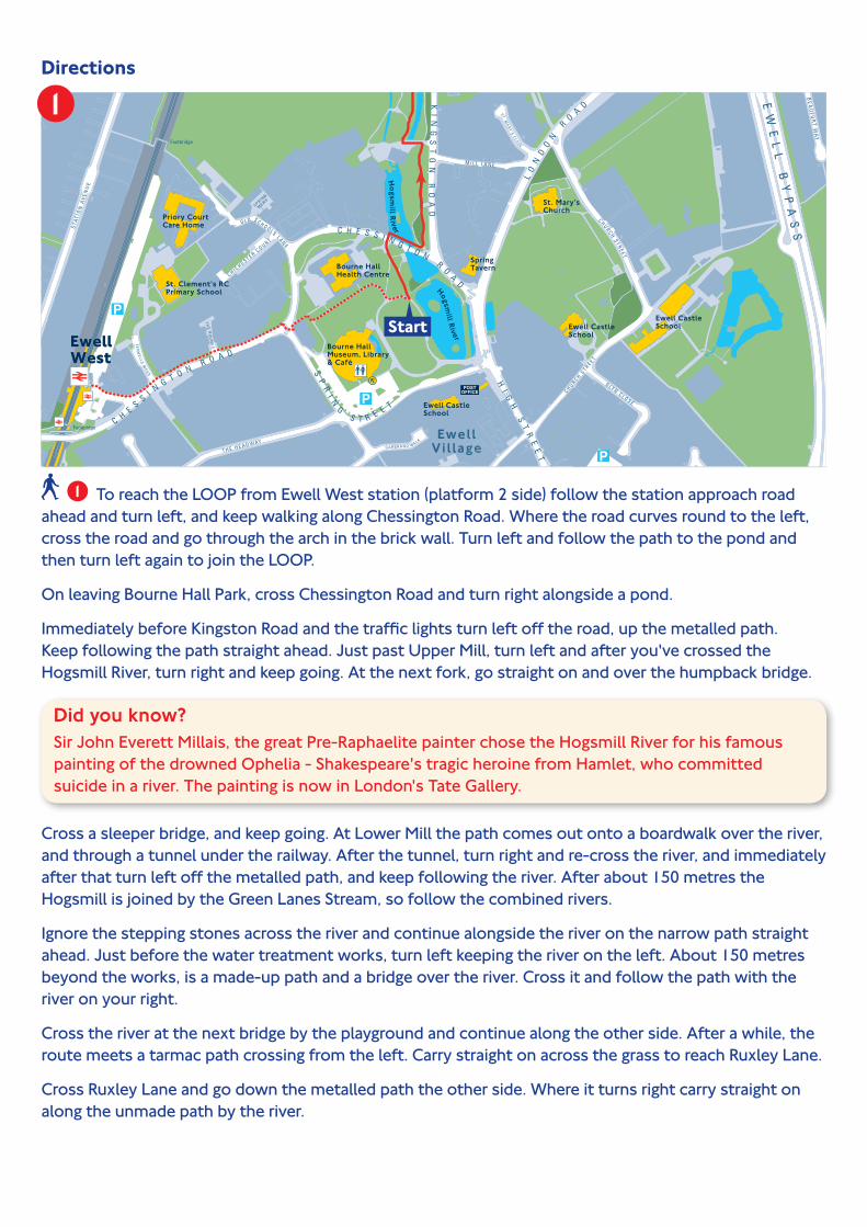
To reach the LOOP from Ewell West station (platform 2 side) follow the station approach road ahead and turn left, and keep walking along Chessington Road. Where the road curves round to the left, cross the road and go through the arch in the brick wall. Turn left and follow the path to the pond and then turn left again to join the LOOP.
On leaving Bourne Hall Park, cross Chessington Road and turn right alongside a pond.
Immediately before Kingston Road and the traffic lights turn left off the road, up the metalled path. Keep following the path straight ahead. Just past Upper Mill, turn left and after you've crossed the Hogsmill River, turn right and keep going. At the next fork, go straight on and over the humpback bridge.
Did you know? Sir John Everett Millais, the great Pre-Raphaelite painter chose the Hogsmill River for his famous painting of the drowned Ophelia - Shakespeare's tragic heroine from Hamlet, who committed suicide in a river. The painting is now in London's Tate Gallery.
Cross a sleeper bridge, and keep going. At Lower Mill the path comes out onto a boardwalk over the river, and through a tunnel under the railway. After the tunnel, turn right and re-cross the river, and immediately after that turn left off the metalled path, and keep following the river. After about 150 metres the Hogsmill is joined by the Green Lanes Stream, so follow the combined rivers.
Ignore the stepping stones across the river and continue alongside the river on the narrow path straight ahead. Just before the water treatment works, turn left keeping the river on the left. About 150 metres beyond the works, is a made-up path and a bridge over the river. Cross it and follow the path with the river on your right.
Cross the river at the next bridge by the playground and continue along the other side. After a while, the route meets a tarmac path crossing from the left. Carry straight on across the grass to reach Ruxley Lane.
Cross Ruxley Lane and go down the metalled path the other side. Where it turns right carry straight on along the unmade path by the river.

Did you know? Spare a thought for the locals of a couple of hundred years ago, whose idyllic peace was periodically shattered by one of the many gunpowder mills exploding. The Upper Mill is the sole survivor of the many mills that were once along here and in Kingston.
Keep going, past a bridge and some houses the other side of the river and after a while another playground. Ignore the next bridge and keep going straight ahead with the river on your left. Eventually the route reaches a red brick bridge taking a major road (Kingston Road) over the river.
Just up the road to the right is a bus stop, from which buses can take you back to Bourne Hall Park (route 406) on the far side of the road or to Kingston, or Surbiton railway stations (routes 408 or 418) on this side of the road.
To carry on turn right on Kingston Road to cross the road at the lights, then go back towards and across the river and go through the metal gates on the right. Walk down the path ahead, with the river on the right. You'll see Japanese Knotweed, growing here - unless nipped in the bud, it grows incredibly quickly, covering huge areas, and wipes out all other plants.
The path comes out through a kissing gate, onto a metalled track. There are two options here, either carry on along the river as it curves to the left passing several sports grounds on Old Malden. Ignore the first two bridges and take the third over the river just before the railway bridge. Alternatively, turn right over the bridge, and on reaching the main road, cross and walk up Cromwell Road opposite. Turn left at Grafton Road and then left down Royal Avenue. Go through the little barrier and go straight on past St. Mary's Road. Where the road forks, cross over, go past the metal barrier straight ahead, and down the unmade track.
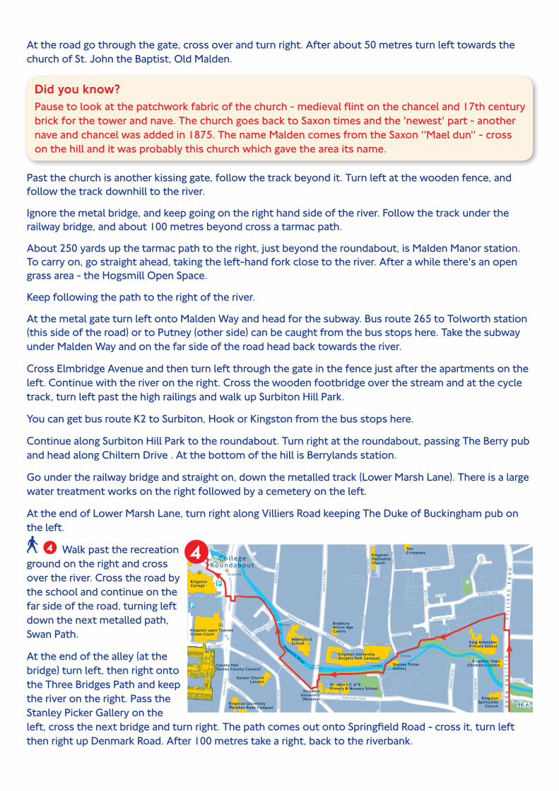
At the road go through the gate, cross over and turn right. After about 50 metres turn left towards the church of St. John the Baptist, Old Malden.
Did you know? Pause to look at the patchwork fabric of the church - medieval flint on the chancel and 17th century brick for the tower and nave. The church goes back to Saxon times and the 'newest' part - another nave and chancel was added in 1875. The name Malden comes from the Saxon ''Mael dun'' - cross on the hill and it was probably this church which gave the area its name.
Past the church is another kissing gate, follow the track beyond it. Turn left at the wooden fence, and follow the track downhill to the river.
Ignore the metal bridge, and keep going on the right hand side of the river. Follow the track under the railway bridge, and about 100 metres beyond cross a tarmac path.
About 250 yards up the tarmac path to the right, just beyond the roundabout, is MaIden Manor station. To carry on, go straight ahead, taking the left-hand fork close to the river. After a while there's an open grass area - the Hogsmill Open Space.
Keep following the path to the right of the river.
At the metal gate turn left onto Malden Way and head for the subway. Bus route 265 to Tolworth station (this side of the road) or to Putney (other side) can be caught from the bus stops here. Take the subway under Malden Way and on the far side of the road head back towards the river.
Cross Elmbridge Avenue and then turn left through the gate in the fence just after the apartments on the left. Continue with the river on the right. Cross the wooden footbridge over the stream and at the cycle track, turn left past the high railings and walk up Surbiton Hill Park.
You can get bus route K2 to Surbiton, Hook or Kingston from the bus stops here.
Continue along Surbiton Hill Park to the roundabout. Turn right at the roundabout, passing The Berry pub and head along Chiltern Drive . At the bottom of the hill is Berrylands station.
Go under the railway bridge and straight on, down the metalled track (Lower Marsh Lane). There is a large water treatment works on the right followed by a cemetery on the left.
At the end of Lower Marsh Lane, turn right along Villiers Road keeping The Duke of Buckingham pub on the left.
Walk past the recreation ground on the right and cross over the river. Cross the road by the school and continue on the far side of the road, turning left down the next metalled path, Swan Path.
At the end of the alley (at the bridge) turn left, then right onto the Three Bridges Path and keep the river on the right. Pass the Stanley Picker Gallery on the left, cross the next bridge and turn right. The path comes out onto Springfield Road - cross it, turn left then right up Denmark Road. After 100 metres take a right, back to the riverbank.
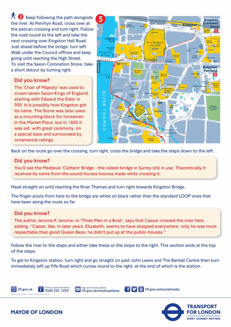
Keep following the path alongside the river. At Penrhyn Road, cross over at the pelican crossing and turn right. Follow the road round to the left and take the next crossing over Kingston Hall Road. Just ahead before the bridge, turn left. Walk under the Council offices and keep going until reaching the High Street. To visit the Saxon Coronation Stone, take a short detour by turning right.
Did you know? The 'Chair of Majesty' was used to crown seven Saxon Kings of England, starting with Edward the Elder in 900. It is possibly how Kingston got its name. The Stone was later used as a mounting block for horsemen in the Market Place, but in 1850 it was set, with great ceremony, on a special base and surrounded by ornamental railings.
Back on the route go over the crossing, turn right, cross the bridge and take the steps down to the left.
Did you know? You'll see the Medieval 'Clattern' Bridge - the oldest bridge in Surrey still in use. Theoretically it received its name from the sound horses hooves made while crossing it.
Head straight on until reaching the River Thames and turn right towards Kingston Bridge.
The finger-posts from here to the bridge are white on black rather than the standard LOOP ones that have been along the route so far.
Did you know? The author Jerome K Jerome, in 'Three Men in a Boat', says that Caesar crossed the river here, adding, ''Caesar, like, in later years, Elizabeth, seems to have stopped everywhere: only he was more respectable than good Queen Bess; he didn't put up at the public-houses.''
Follow the river to the steps and either take these or the slope to the right. This section ends at the top of the steps.
To get to Kingston station, turn right and go straight on past John Lewis and The Bentall Centre then turn immediately left up Fife Road which curves round to the right, at the end of which is the station.