Embed Size (px)
Citation preview
London-Edinburgh-London: a gentleman’s ride
For me, a slow Audax rider, there is enormous attraction in contemplating a 1400 kilometre ride
where the average speed is 12.2 kilometres per hour and a maximum ride time of 116 hours. I do
300 kilometres with stops, in about 18 hours. Normal ride conditions allow a maximum of 20 hours
to complete 300 kilometres, leaving me about two hours for sleep, maybe. For London-Edinburgh-
London (LEL) with an average speed of 12.2, I get 25 hours not 20 hours to complete 300km… in
theory there is my sleep time.
Consequently, it is a warm late-summer morning on
the 28th July 2013. The time is 07:15. I put on my
riding gear and lead my bike to the corral to join the
other ‘F Group’ riders for our 07:30 start in the LEL.
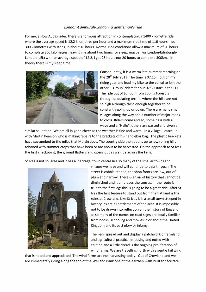
The ride out of London from Epping Forest is
through undulating terrain where the hills are not
so high although close enough together to be
constantly going up or down. There are many small
villages along the way and a number of major roads
to cross. Riders come and go, some pass with a
wave and a “Hallo”, others are passed and given a
similar salutation. We are all in good cheer as the weather is fine and warm. In a village, I catch up
with Martin Pearson who is making repairs to the brackets of his handlebar bag. The plastic brackets
have succumbed to the miles that Martin does. The country side then opens up to low rolling hills
adorned with summer crops that have been or are about to be harvested. On the approach to St Ives
the first checkpoint, the ground flattens and opens out as we ride across the Fens.
St Ives is not so large and it has a ‘heritage’ town centre like so many of the smaller towns and
villages we have and will continue to pass through. The
street is cobble-stoned, the shop fronts are low, out of
plum and narrow. There is an air of history that cannot be
diminished and it embraces the senses. If the route is
true to the first leg: this is going to be a great ride. After St
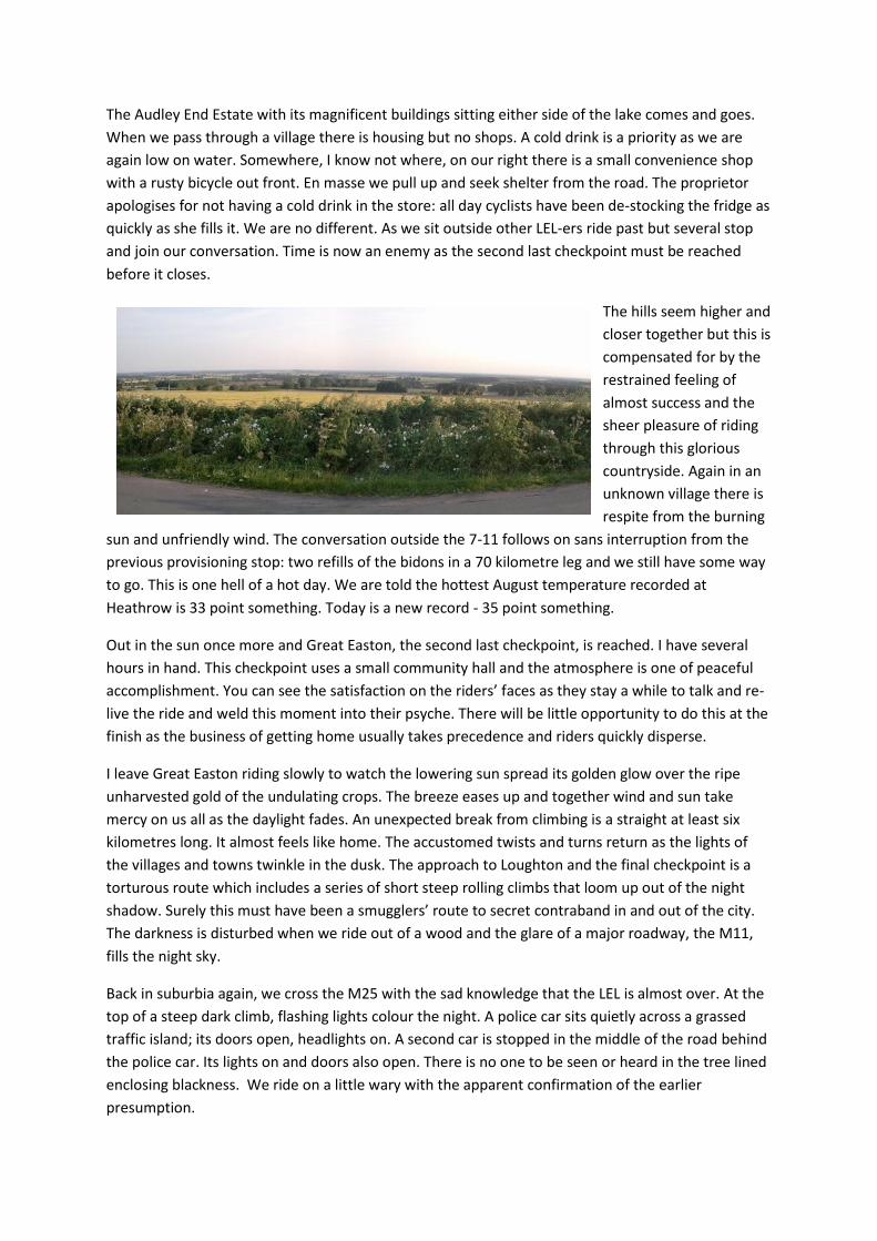
Ives the first feature to stand out from the flat land is the
ruins at Crowland. Like St Ives it is a small town steeped in
history, as are all settlements of the area. It is impossible
not to be drawn into reflection on the history of England,
as so many of the names on road signs are totally familiar
from books, schooling and movies in or about the United
Kingdom and its past glory or infamy.
The Fens spread out and display a patchwork of farmland
and agricultural practice. Imposing and noted with
caution and a little dread is the ongoing proliferation of
wind farms. We are travelling north with a gentle tail wind
that is noted and appreciated. The wind farms are not harvesting today. Out of Crowland and we
are immediately riding along the top of the Welland Bank one of the earthen walls built to facilitate

the draining of the Deep Fens. This is awesome; the carriage way is a car-width wide and it takes up
half of the available space on the top of the bank. On our right and below us is a canal that hosts
swans and other birdlife. Beyond that there are
pastures with Lincolnshire/Fen sheep. Out to
our left is cultivation and paddocks with the
reintroduced Fen horses.
The sun is shining and it is a glorious day.
Groups of riders form, separate and reform as
we ride and talk. I ride for a while with Steve (I
think), he is very proud of his bespoke bike with
frame lugs from Velocity in Oz. At sections of
the bank where it was widened to allow vehicles
to pass, riders occasionally sit in small groups or
individually to have a break. But more so just to admire and take in the view before moving on. Even
though the speed for LEL is 12.2 kilometre per hour there is a need to keep an eye on the time.
The next checkpoint is Kirton, just south of Boston on the east coast. Out of Kirton we cross
numerous drains and canals and then the River Witham. The river looks like a large canal due to the
high banks that contain it and facilitate the locks and gates for the innumerable drains that quilt the
land. The drains are a legacy from the Dutch who immigrated to England to assist with the claiming
of the Fens. Modern house boats complement the traditional low and narrow canal house boats that
seem to dominate the aquatic population. Holiday camps beside the river and canals etch
themselves into the memory.
We cross over the canal at Kirkstead and make for Market Rasen. As we do small wooded areas
begin to appear more regularly but it is obvious from the lay of the land that we are still on the Fens.
The roads are mostly straight between the cultivation with the occasional twist and turn when they
run through the woods. Evening approaches with a diminishing of the light. It is a beautifully calm
and pleasantly warm evening as we easily negotiate our access to the Humber Bridge in Barton-
upon-Humber. Picture Time. It is a slow ride across, taking in the view and the evening airs.
Once across there is some consternation getting
out of the car parks on the northern side. Several
groups of riders have encamped there to put on
their night riding gear as they watch to see who
does not come back from one of the numerous exit
possibilities. Zoom out on the Garmin to get some
perspective as to how to cross over the A15: hang
wide and left in the three car parks seems the best
option. A couple of riders doing the same exercise
agree. Success and within minutes we are re-
established in the country-side: the route snakes through the gaps between the numerous towns
and villages throwing light into the sky above the north bank of the Humber.

By the time Market Weighton lights the night
there are numerous climbs, and as we ride along
the ridges, twinkling vistas reach out across the
dark to the constant glow of the distant cities we
are riding between. Pocklington is the fourth
checkpoint at 336 kilometres. The checkpoint is
full, beds are limited and at a premium.
Experience as a slow rider empowers and with
foresight alternative sleeping arrangements were
made for the entire ride. Bed and shower then
hello sleep - in the motel.
Awake at 06:00 on the road by 07:00 and it looks like a glorious day for riding. Apparently in the UK
hot summer days are followed by colder days with fresh westerly/south-westerly winds. Yesterday
apparently was a hot day: damn. There is a moderate breeze and a certain coolness in the air. Out of
Pocklington the terrain is undulating as the route twists and turns between the patchwork
cultivation and woods. We ride on narrow lanes and byways through crops dotted with poppies. The
route crosses A and B roads as well as other lanes and byways. All too often a rider who has missed a
turn and is too far away to hear any call is seen riding off into in the distance. There is no substitute
for a GPS as the turns are close together and the accumulated differences between the route sheet
and an odometer can be disastrous.
Some of the byways are completely covered with dirt but the multitude of observable bicycle tracks
confirms the route. Other lanes are still sealed but
require maintenance; it is safer to ride on the
verge than the road proper. We have slowly
climbed onto a series of ridges with hedgerow
constrained views of the extensive plains below. A
stop at a gateway and later a side road to check
out the view are worthwhile. A short climb and we
are at the magnificent gateway that marks Castle
Howard. The road is narrow but inspiring due to
the road furniture that was built to show power
and position. The buildings and surrounding
environs reinforce the impression of prestige that only comes from ‘old money’. I would like to stop
and look but the packed car parks are host to a multitude of tourists: ride on… turn left at the gates
beside the Great Lake and head into the wooded hills.
After Castle Howard the route enters a changed land. The low undulating hills are now higher and
closer together like white capped waves rolling across a stormy ocean. The inclines are steep but
short as we ride the narrow lanes and byways. It is magnificent country that encloses but nurtures
the spirit. It may not be the home of Robin Hood but it is refreshing and uplifting to ride in the
woods after so much flat land with intrusive agriculture.

There is one noted drop and climb that is posted at 1:6 overall. Talk has it that Garmins have
reported intermediate inclines around to 25% here. No worries, I am prepared and always carry
cleat covers to protect my cleats when I walk
up knee blowing pseudo cliffs. As I descent
following another rider there is a 90 degree
curve at the bottom, it is covered with water
and a great big yellow tip truck that looks like
a Tonka Truck is about to enter the corner. The
guy in front of me goes bush through the
water as I hit the brakes and get off into the
mud and slush beside the road... Love those
disk brakes.
The route to Thirsk then follows what, by
comparison, appear to be highways as it winds through farmland towards the checkpoint. An English
summer implies rain, it is de rigour. We are riding north-west the wind is from the south-west. The
rain rides the wind. Many riders stop time and again and put on or take off their rain gear as we
weave in and out of heavy showers. I am too lazy to stop and ride on; the cold and wet remind me of
home. The rain drops are large and heavy like those of a tropical storm. Time and again, after only a
few minutes there is run-off and water covering the road in a local inundation. The weather follows
us to Thirsk.
The road out of Thirst slowly climbs through the undulating landscape towards Barnard Castle. The
hills get a little closer and steeper but the land is still a patchwork of cultivation. A moderate breeze
is blowing but gusts hit higher towards a fresh
breeze. Melsonby is about 10 kilometres
outside of Barnard Castle and the terrain is
definitely up and down. Again, there are
absolutely inspiring views to be had if one
could only find a break in the hedgerows. The
road drops sharply to the River Tees. The
crossing is via the classic rickety bridge
followed by a couple of 90 degree corners
separated by short sharp climbs. The final
descent into Barnard Castle is a pleasant
reward for a solid morning plus in the saddle.
The ride out of Barnard Castle is the same old, same old: cultivation to the left and cultivation to the
right, rolling country side and so much green and gold to harvest. The breeze has strengthened over
the day and now it is a fresh breeze with intermittent drops back to moderate but there are also
sallies up to strong. Middleton-in-Teesdale is the first reasonable town after Barnard Castle. Notable
is the number of bikes leaning against the shop walls or parked on the green. Riders are having a
break before the climb over Yad Moss at 598 metres.

Out on the road again there is a notable change. The road is a tree lined avenue that runs beside the
River Tees as it winds downs though gently undulating country. The wind is noticeable as we slowly
climb past High Wind heading
towards open ground and Yad
Moss. The view below of the
River Tees ensconced in its
green valley constantly entices
the eyes to the left. At Langdon
Beck we are on the moors. The
ascent steepens for a couple of
corners before the road
straightens and settles back to
a moderate incline of 3%-5% (estimate). This is the land of endless stone fences leading to stone
yards and stone farm houses and stone out buildings. The wind gusts up to a strong breeze and
swings from the left to a full-on head wind: making it difficult to settle into a rhythm. At 598 metres
there is nowhere to hide but the view and sense of accomplishment are supreme.
The run into Alston is fast. The descent is straight down with only a few curves at the very top. The
grid is no hindrance but the sheep are. Alston is notorious for the steep descends leading into it and
the 15% cobbled main street. The cobbles are well rounded and polished; many riders take the
opportunity to get off and walk down the grade or stop and buy a drink before heading out as the
late afternoon begins to chill. The evening ride into Brampton is through wide valleys with a
seemingly endless patchwork of fenced-off farmland and wooded hills in the background.
The ride from Brampton to Gretna Green is relaxing. England is firmly concreted in my mind as being
a green patchwork of cultivation and agricultural land on low rolling hills and dales with two
exceptions. Exception one is when it is deep forest with steep rolling hills. Exception two is the
moors. This image is shattered at Gretna Green. Gretna Green to Moffat at night is a nightmare. As
fortune has it, I get to share the experience with a German guy working and residing in the UK. The
route runs beside over and around the A74 (M) to Lockerbie. There is not much to see and the land
is semi-flat with long but slight grades up and down: visually and mentally tiring, as is the noise from
the cars a couple of hundred metres away. It
is past annoying. In places the road surface is
as rough as pave and hard to see in the dark,
so we ride on the footpath or gutter rather
than stay on the road: a highly recommended
practice. It is hard to express just how dis-
heartening it is to ride for 50 kilometres
beside an M road. It is equally hard to express
just how over joyed we were to reach the exit
that took us over the M74 and into Moffat.
Moffat at last and the time is a little past
midnight. Distance ridden today was 288 kilometres into a fresh to strong breeze. Tonight there is a
four-poster bed in the Moffat Hotel. It is a hard life being a randonneur. Next morning breakfast is
at 07:00 and on the road by 08:00. Again the morning air is fresh and there is a steady 10 kilometre

climb, estimated at 5% -7%, out of Moffat. It is a glorious morning and there is a mist rising from the
valley as I climb.
Approximately 1000 riders from 34 countries entered the LEL, of these some 550 are from 33
countries other than the UK: e.g. Japan, Bolivia, USA, Brazil…consequently not all the riders can
speak or read English. Some have ridden Paris-
Brest-Paris where every corner of the route is
sign posted with a direction arrow. LEL is not
the same. There is a route sheet and GPS but
very little local signage. Without a GPS it is
exceeding difficult for a rider, let alone one
with little English, to navigate the route. This
explains, in some way, the number of times a
rider could be seen at a corner waiting for
assistance. Raphael, my new best friend from
Brazil, was one such rider who continually
crossed my path. We met on the climb out of
Moffat and over the next three days I found him, with regularity, on corners, in villages or at a
checkpoint waiting to ride with someone who could navigate the route.
The ride to Edinburgh is through forestry and quiet farm lands. The hills and valleys are wide and
deep. The climbs are several kilometres long on gentle slopes and the descents are relaxing. It is nice
to have the time to admire the hills and dales and soak up the Scottish air. The last ridge arrives and
Edinburgh lies to our left down on the coastal plain. The Edinburgh checkpoint is in a suburb that has
one overriding feature: hills with suburban inclines – short but steep. The ride in and out of the
checkpoint is through substantial traffic, not seen for a few days and it takes a little time to re-
acclimatise to the pace. The ride out of Edinburgh is 20 kilometres of short sharp climbs
interspersed with longer but still steep climbs. It is flat for 100 metres round the Lime Factory before
the final ascent to the top of the hills overlooking Edinburgh from the south. There is a procession of
riders on the last climb as the tour settles into a rhythm against the fresh breeze and 6%-9%
(estimate) grade. This is one climb that pays back many fold. The view from the top is awesome.
The ride through the valley on the other side of the range is against the wind that is blowing a strong
breeze. Grouped riders separate out as the breeze takes its toll on their formations and speed. Small
formations move slowly down the valley. I would love to hide behind someone for respite but alas
they are too far ahead or too far behind. A small group catches up and passes so I tag on behind. It is
an unwritten rule that it is ok to tag on if passed: not polite to sneak up behind and lock in without
so much as a “Hello”. Damn, within minutes we roll off the upland and I leave them behind on the
descent. On the flat there is a weakening of the wind and I join up with ‘Batman’. His name escapes
me but we rode together on the Castles and Coast ride in Suffolk the previous weekend. On that ride
he wore a Batman jersey, hence the name. The route now winds through narrow valleys with small
streams flanked by the narrow road we ride. We arrive at Innerleithen and a few kilometres south is
the Taquair checkpoint: The only checkpoint that offers a refreshing single malt scotch and specially
made and decorated LEL cake. There is cake and scotch for all...True hospitality at last.

South of Taquair the mountainous country
continues. The hills are covered in what can
best be described as unimproved pasture.
The climbs are long as are the descents. The
livestock is in unfenced land, which means
they are on the road. The first valley of sheep
has smart sheep. They are Scottish Black Face
and on approach if they deign to look up they
casually resume their feeding. The second
valley of sheep has dumb Cheviot sheep.
They have rabbit like ears and are stupid. On
approach they look up from their feeding and
run to congregate on the road where they run hither and thither and dither before standing in the
drain or on the verge, a little nerve racking when having fun on the descents.
Past the sheep we are again in a valley with steep sides covered in forestry plantations. It is relaxing
to ride in the late afternoon with the water
murmuring and the sun casting shadows that
touch the river across the narrow valley. The
surprise of the day is the Samye Ling Tibetan
Centre. It sits quietly beside the road, the
white and gold stupa glistening in the
sunlight. The Eskdalemuir checkpoint is a
couple of kilometres further along the road.
It is a welcome break.
Back on the bike, the route continues
through valleys with tree plantations until
Langholm. After Langholm the relentless southern wind gusts to a strong breeze as the rain,
promised for hours by the low grey clouds breaks and drenches all and sundry in seconds. The rain
gear is broken out but too late to prevent the soaking. Outside Canonbie is a “Welcome to England’
sign. We have entered Scotland and now we have left it without so much as an official ‘Hello, kiss my
arse’ or ‘bugger off’ from the Scots. Here in the middle of a down pour is a welcome to England sign.
Unbelievable as it sounds, the rain stops, the sun comes out and is followed by a double rainbow.
The rain starts again but is much lighter and
the wind abates some too. Longtown, which
is adjacent to Gretna completes the loop into
Scotland. Impossible thoughts brighten up the
gloom: Was it only the previous evening I
passed through here on the way north to
Greta and then Edinburgh this morning? The
answer to both is an incredulous “Yes”.
Once back in England the terrain is again
open, relatively flat and quilted with
agricultural endeavour. The rain continues to

come and go as the evening progresses until Brampton checkpoint offers shelter from the weather.
While resting at the checkpoint the rain is finally blown away by a chilling breeze. Dressed for the
cold it is 20:00 and time to leave. The ride out of Brampton is an assembly of short steep climbs
through seriously dark man-made or tree lined tunnels, cannot tell in the dark and did pay attention
on the way north. The dynamo driven IQ light simply disappears into the wall of darkness. The
battery powered Ay-Up light supplements the IQ and the tunnels are a cone of light.
Out on the road, it is a dark night with clouds scurrying across a smuggler’s moon. Keeping the
pedals light against the climb and the wind, and the cadence synchronised to the music playing in my
ears, it is a great night for riding. Until Alston that is and the cobbled incline causes the back wheel
to slip and spin. The cleat covers come out and the street is successfully negotiated. . I am not sure
of the algorithm but it goes something like this, ‘Each day on the road adds 0.5% to any incline as
does each Beaufort Wind Scale class above Gentle’. So after three windy days on the road the ride is
in danger of achieving Iliad like recounting of climbing ability…
Back in the saddle, it is immediately apparent that the climb out of Alston is every bit as tedious as
the climb out of Brampton and there is still the long straight climb up Yad Moss to come. At the grid
at the top of Yad Moss, a weak beam of light is seen to pop in and out of the darkness ahead.
Another fool is out tonight. I pass on the plateau prior to dropping down the southern face. For the
descent, it is the big chain ring and the 11 tooth sprocket. The lights shoot out as far and as bright as
possible, good lights make for a fast and safe descent from the Moors. The route south varies from
the route north on the approach to Barnard Castle. At Middleton-in-Teesdale the south route
crosses the River Tees and leads through half a dozen villages. Each village has a steep climb to gain
entry and an even steeper climb to escape. Rekindling memories of the departure from Brampton
there are a number of dark cavernous tunnels that consume both the illumination of the lights and
the remaining good humour. Curse the men and women who first lived and built in any of these
villages. Eventually one last sharp drop-off to go down into and crawl back out of to re-cross the
River Tees. Hello Barnard Castle. It is 03:00 and 311 kilometres for the day.
A sleepy breakfast at 08:00 is consumed before heading out the door to be on the road by 09:00.
Other riders pass by in groups as I leave
Barnard Castle. The air has a slight chill but
the 09:00 sun keeps it at bay. Once again we
are rolling through the gently undulating
green and harvest gold agrarian patchwork
of the English country side. It is a wonderful
day and it’s great to be alive. The LEL is
special because of the English and Scottish
country side. It does not matter that
numerous people in many of the villages and
towns we pass through ask, “Why so many
bikes?” or the pleasant and unassuming
“What are you all doing, here?” There is little localised publicity for this ride, unlike Paris-Brest-Paris,
which has seen generations come and go. The LEL is very British in that it quietly and unassumingly
goes about its business. We cruise the fertile plains of the river flats back to Thirsk.

The ride south of Thirsk is uneventful until the rain initiated detour of two days previous. A number
of riders are standing talking and several more come in from side-lanes: obviously having navigation
problems. Consulting with various GPSs it is evident that there is more than one version of the route.
The early version of the route does not have the diversion on it. I know the way from here and lead
out down a dusty lane. The lanes are narrow and the enclosing hedgerows high. An impatient driver
tries to force past us as we turn right at a blind Y junction. Two cars coming from the opposite
direction are also entering the corner; funny how the British all drive in the middle of the road or
lane. The bikes are sandwiched between the three cars and the hedgerows as the drivers brake and
swerve. We stop in a melee of cars and bikes. Directed curses flow as we pick our way through the
confusion and continue on our way.
Back on the route again, the open fields
change to hilly woods and with some
anticipation approach the steepest descent
and climb of the LEL. There is no Tonka Truck
this time and the road quickly leads to the
Great Lake and through the grounds of Castle
Howard. The now familiar road furniture is
somehow comforting. Several riders have
stopped at the last obelisk to read the
dedications. There is a need to press on as
the day has a way of slipping away.
The second half of the ride from Thirsk to
Pocklington is back over the tracks overblown with dirt and fields full of poppies. After Pocklington,
the late afternoon checkpoint, seemingly out of nowhere the A15 passes overhead before entering
the maze of car parks on the north side of the Humber Bridge. Crossing the Humber in the early
evening the view is again spectacular. The grandness of the bridge and breath taking view awe and
overwhelms as before. Life is good.
Darkness approaches and brings with it increased wind and the rain. The terrain has long gentle
slopes that the wind adds several degrees
to as it presses the rain against the face and
warm outer clothing. The pace slows
significantly for the wind and the rain are in
control. It is foolish to push against the dual
forces of nature and uselessly waste
energy. Time is on my side with the low
average speed; I just have to keep the
pedals light, stay dry and be comfortably
happy in the cold and wet. The headlights
project needle like into the dark wall of
falling water and the purple line in the GPS
shows the way to Market Rasen. Arrival time is a little behind schedule: it is 21:00 at the checkpoint.
Over dinner the decision is made to sleep here and not go on to Kirton as originally planned. A

shower and bed are available so the facilities are claimed and used. Wake up time arranged and the
bed identified in the sea of darkness. It is 22:00 and the end of a 217 kilometre day.
At 04:00 on the last day it feels good to wake up fully dressed and ready for the day’s ride. The
cafeteria is filled with souls with the same intention. The sun is up and it looks like it will be a day
with blue skies and more than a little wind. There are riders all around in the cycle park. We saddle
up and hit the road at 05:00. The ride through the English country side is still enthralling after four
days of adventure and exploration. As the day warms up the wind strengthens to a moderate to
fresh breeze gusting to strong. The head wind ensures riders stay closely grouped on the narrow Fen
Banks and it is obvious that some do not want to share the load. But it cuts both ways. Some riders
prefer to lead and others follow. It is nice to have a break from the wind and tuck in behind. It is also
an opportunity to chat and discuss the LEL and recall personal highs and sometimes lows while
taking in the beauty of the Fens. The day has just begun when we ride in to Kirton and a second
breakfast.
Back on the road again, this is the last day and it is noticeable that the groups of riders are closer
together and more frequent. On the first day starting times brought them together, today
independent of rider capability and riding style, finishing time regroups them. It is a glorious day, the
sun is shining down from an open blue sky. This is not your typical English summer day. We have had
three of them consecutively: grey skies, sometimes a little - sometimes a lot of rain and a moderate
breeze putting a slight nip in the air. Today is different. It is getting hot. But the ride compensates.
There is no getting over the beauty of the English country side, especially after cycling through it for
more than a thousand kilometres. It fills your senses and lightens the heart. We drop off the Welland
Bank with its aquatic vista and cycle into Crowland with its remnants of a once great cathedral.
On the flat land the heat and the wind are of more concern. The wind farms are harvesting the
moderate to fresh breeze that blows in our
face. At Whittlesey, the first village with a
service station, as a group with one thought,
we stop to fill our empty bidons and rest from
the wind and rising temperature. As we arrive
another group leaves and before we leave our
place is filled by incoming riders. We use all
the re-fill water by St Ives. The checkpoint is a
cool and a welcome lunchtime haven. The
southern route is through the business centre
of St Ives. It is a hot day and the allure of a
half hour diversion for a tall Strawberry Ice at
Costa in air conditioned bliss is too strong. Cool and refreshed it is a short hop to the picturesque
bridge on London Road and the way out of St Ives.
Villages are again frequent and spice up the afternoon ride: as small oases in the verdant pastures
their occasional shade offers some respite from the sun and the hedge rows abate the wind. At
Fowlmere the southern route departs from our way north. The terrain closes in and in numerous
small groups we ride, in the afternoon sun, through rolling farmland with noticeably long climbs.
The Audley End Estate with its magnificent buildings sitting either side of the lake comes and goes.
When we pass through a village there is housing but no shops. A cold drink is a priority as we are
again low on water. Somewhere, I know not where, on our right there is a small convenience shop
with a rusty bicycle out front. En masse we pull up and seek shelter from the road. The proprietor
apologises for not having a cold drink in the store: all day cyclists have been de-stocking the fridge as
quickly as she fills it. We are no different. As we sit outside other LEL-ers ride past but several stop
and join our conversation. Time is now an enemy as the second last checkpoint must be reached
before it closes.
The hills seem higher and
closer together but this is
compensated for by the
restrained feeling of
almost success and the
sheer pleasure of riding
through this glorious
countryside. Again in an
unknown village there is
respite from the burning
sun and unfriendly wind. The conversation outside the 7-11 follows on sans interruption from the
previous provisioning stop: two refills of the bidons in a 70 kilometre leg and we still have some way
to go. This is one hell of a hot day. We are told the hottest August temperature recorded at
Heathrow is 33 point something. Today is a new record - 35 point something.
Out in the sun once more and Great Easton, the second last checkpoint, is reached. I have several
hours in hand. This checkpoint uses a small community hall and the atmosphere is one of peaceful
accomplishment. You can see the satisfaction on the riders’ faces as they stay a while to talk and re-
live the ride and weld this moment into their psyche. There will be little opportunity to do this at the
finish as the business of getting home usually takes precedence and riders quickly disperse.
I leave Great Easton riding slowly to watch the lowering sun spread its golden glow over the ripe
unharvested gold of the undulating crops. The breeze eases up and together wind and sun take
mercy on us all as the daylight fades. An unexpected break from climbing is a straight at least six
kilometres long. It almost feels like home. The accustomed twists and turns return as the lights of
the villages and towns twinkle in the dusk. The approach to Loughton and the final checkpoint is a
torturous route which includes a series of short steep rolling climbs that loom up out of the night
shadow. Surely this must have been a smugglers’ route to secret contraband in and out of the city.
The darkness is disturbed when we ride out of a wood and the glare of a major roadway, the M11,
fills the night sky.
Back in suburbia again, we cross the M25 with the sad knowledge that the LEL is almost over. At the
top of a steep dark climb, flashing lights colour the night. A police car sits quietly across a grassed
traffic island; its doors open, headlights on. A second car is stopped in the middle of the road behind
the police car. Its lights on and doors also open. There is no one to be seen or heard in the tree lined
enclosing blackness. We ride on a little wary with the apparent confirmation of the earlier
presumption.

Epping Forest road signs give notice that it is only minutes to the end of this ride. Climb past Deben
Green; one last left turn and we are on the home straight to the school ahead. The pace of the LEL
left me feeling like a fast rider, I was able to comfortably do my planned distance for the day and get
a good night’s sleep. It would be wonderful to simply turn around and do the ride again but reality
beckons and refuses to be ignored. The LEL is a great ride, it took me through so many varied and yet
oh so beautiful English and Scottish scenic clichés … and subsequently re-enforced the visual
stereotypes in my memory. Thank you to all who made LEL happen in 2013 and “wasn’t it awesome”
to all who rode it.