Embed Size (px)
Citation preview

Lolo First 50
Road Decommissioning Project
Environmental Assessment
USDA Forest Service
Lochsa Ranger District
Nez Perce- Clearwater National Forest
July 2014

Lolo First 50 Road Decommissioning Environmental Assessment
Lolo First 50 Road Decommissioning
Environmental Assessment
Lochsa Ranger District
Nez Perce- Clearwater National Forest
Northern Region, USDA Forest Service
July 28, 2014
Responsible Agency: USDA Forest Service
Responsible Official: Craig Trulock, District Ranger
Lochsa District
502 Lowry St.
Kooskia, ID 83539
For further information, contact: Karen Smith, Interdisciplinary Team Leader
Kamiah Ranger Station
1012 Hwy 64
Kamiah, ID 83536
“The U.S. Department of Agriculture (USDA) prohibits discrimination in all its programs and activities
on the basis of race, color, national origin, age, disability, and where applicable, sex, marital status,
familial status, parental status, religion, sexual orientation, genetic information, political beliefs, reprisal,
or because all or part of an individual’s income is derived from any public assistance program. (Not all
prohibited bases apply to all programs.) Persons with disabilities who require alternative means for
communication of program information (Braille, large print, audiotape, etc.) should contact USDA's
TARGET Center at (202) 720-2600 (voice and TDD). To file a complaint of discrimination, write to
USDA, Director, Office of Civil Rights, 1400 Independence Avenue, S.W., Washington, D.C. 20250-
9410, or call (800) 795-3272 (voice) or (202)720-6382 (TDD). USDA is an equal opportunity provider
and employer.”

Lolo First 50 Road Decommissioning Environmental Assessment
Table of Contents CHAPTER 1. PURPOSE OF AND NEED FOR ACTION .......................................................... 1
A. Introduction ............................................................................................................................ 1
B. Background ........................................................................................................................... 3
C. Purpose and Need .................................................................................................................. 6
D. Proposed Action .................................................................................................................... 7
E. Desired Condition .................................................................................................................. 7
F. Existing Condition ................................................................................................................. 7
G. Public Involvement ............................................................................................................... 8
H. Environmental Issues ............................................................................................................ 8
I. Scope of the Analysis ........................................................................................................... 11
J. Decision to Be Made ............................................................................................................ 11
CHAPTER 2. ALTERNATIVES ............................................................................................... 12
A. Alternative Development Process ....................................................................................... 12
B. Alternative 1. No Action .................................................................................................... 12
C. Alternative 2. Proposed Action .......................................................................................... 12
E. Alternatives Considered but Not Analyzed in Detail .......................................................... 14
F. Alternative Comparison ....................................................................................................... 14
CHAPTER 3. AFFECTED ENVIRONMENT AND ENVIRONMENTAL EFFECTS ............ 16
A. Aquatic Resources.............................................................................................................. 16
C. Road Maintenance vs. Decommissioning Costs ............................................................ 20
D. Wildlife ............................................................................................................................... 22
CHAPTER 4. Regulatory Framework and Consistency .............................................................. 24
A. Effects of Alternatives on Prime Farm land, Rangeland, and Forest land .......................... 26
B. Energy Requirements of Alternatives ................................................................................. 26
C. Effects of Alternatives on Minorities and Women .............................................................. 26
D. Environmental Justice ......................................................................................................... 27
E. List of Preparers .................................................................................................................. 27
Appendix A. References .............................................................................................................. 28

Lolo First 50 Road Decommissioning Environmental Assessment
1
CHAPTER 1. PURPOSE OF AND NEED FOR ACTION The Forest Service has prepared this Environmental Assessment in compliance with the National
Environmental Policy Act (NEPA) and other relevant Federal and State laws and regulations. Chapter
1 identifies the purpose and need for action, the scope of the analysis, and the decisions to be made.
Chapter 2 describes the action and no action alternative, and alternatives considered but eliminated
from detailed analysis. Chapter 3 characterizes the affected environment and discloses the direct,
indirect, and cumulative environmental impacts that would result from the alternatives.
Additional documentation, including more technical reports used in this analysis is available upon
request at the Nez Perce-Clearwater Forest Supervisors Office Annex in Kamiah, Idaho.
A. Introduction
The Lochsa Ranger District of the Nez Perce-Clearwater National Forest proposes to decommission
41 miles of unneeded Forest system roads and 25 miles of non-system skid trail/log jammer
roads in the 78,600 acre Lolo Creek watershed. An intensive roads analysis has determined that
these roads are not needed for future land management activities. Removal of these roads would
improve hydrologic function and reduce adverse impacts to aquatic habitats over the long term.
The project area is located in T33N, R5E and R6E; T34N, R5E, R6E and R7E; T35N, R5E, R6E
and R7E, and T36N, R5E, R6E and R7E. The area lies about 12 miles east of Kamiah, Boise
Meridian, Idaho and Clearwater Counties, Idaho. Please see the attached map for road locations.
Proposed project sites can be found on Maps 1 and 2.
Of the 41 miles of road proposed for decommissioning, the following access restrictions
currently apply: 12 miles are closed yearlong to all motorized vehicles, 11 miles are open
yearlong to all and the remaining 18 miles are open seasonally. Of the 29 miles of roads open
for some form of motorized use, 12 miles (41%) are actually drivable, while 4 miles (14%)
are possibly travelable and 13 miles (45%) are brushed in and impassible. Table 1 below
displays the Forest system roads that would be decommissioned.
Skid trails and old log jammer roads would also be decommissioned. These 25 miles of roads were
identified through satellite imagery (LIDAR) but are not part of the inventoried Forest Service road
system. These roads are typically grown over with trees and some contain log stream crossings which
make them more susceptible to failure when the logs rot and collapse. It has been determined they are
not needed for future management.
The activities would likely begin in 2015 and could take up to 5 years to complete.

Lolo First 50 Road Decommissioning Environmental Assessment
2
Table 1- Forest system roads proposed for decommissioning in the Lolo Creek drainage,
their Travel Plan status and current drivability.
Road
#
Length
(miles)
Current Drivability Road # Length
(miles)
Current Drivability
Travel Plan- Open Seasonally to All Travel Plan-Open Year Round to Small Vehicles
5022-B 0.2 drivable 5179 0.2 drivable
5141-B 1.3 drivable 519-A 0.7 possibly drivable
530-A 0.2 drivable 496 0.2 possibly drivable
535-E 0.8 not drivable 541-C 0.1 possibly drivable
535-C 0.5 not drivable 541-B 0.2 possibly drivable
5130-B 0.5 not drivable 5137 0.4 possibly drivable
535-D 0.6 possibly drivable 5021-B 0.4 possibly drivable
5129 0.3 possibly drivable 5256 0.4 not drivable
5022-A 0.8 possibly drivable 5137-A 0.9 not drivable
Travel Plan- Open Year Round to All 5119-C 1.6 not drivable
455-G 0.2 drivable 5149 0.5 not drivable
5019 3.7 drivable 5101 1.4 not drivable
5020 0.1 drivable 5021-D 0.8 not drivable
5033 1.4 drivable 5021-A 1.0 not drivable
5034 0.9 drivable 5118-B 0.8 not drivable
5127-A 0.2 drivable 5174-A 0.3 not drivable
529 0.6 drivable 5158-D 0.6 not drivable
5174-D 0.5 possibly drivable Travel Plan- Closed Year Round to All Vehicles
528-E 1.0 not drivable 5136 0.5 drivable
519-E 0.1 not drivable 5181 0.2 drivable
541-A 0.8 not drivable 5152-E 1.5 possibly drivable
5142-B 0.1 not drivable 5119-M 0.1 possibly drivable
5158-B 0.2 not drivable 5119-J 0.3 possibly drivable
5158-E 0.2 not drivable 5136 0.9 possibly drivable
5158 0.4 not drivable 519-C 0.3 not drivable
Travel Plan- Open Seasonally to Small Vehicles 528-D 0.8 not drivable
554 1.6 drivable 454-D 0.2 not drivable
5104-A 0.3 not drivable 519-D 0.5 not drivable
No Travel Plan Status 5192-B 0.4 not drivable
5009-B 0.3 drivable 5192 1.6 not drivable
5009-B 0.6 not drivable 5142-A 0.9 not drivable
850185 0.1 not drivable 5136 1.5 not drivable
454-C 0.5 not drivable 5181 0.4 not drivable
5009-C 0.4 not drivable 5111-A 0.4 not drivable
5128 0.5 not drivable

Lolo First 50 Road Decommissioning Environmental Assessment
3
Map 1. Lolo 1st 50 proposed roads for decommissioning, north half.
T36N
T35N
R06E R07E

Lolo First 50 Road Decommissioning Environmental Assessment
4
Map 2. Lolo 1st 50 proposed roads for decommissioning, south half.
T34N
T33N
R06E

Lolo First 50 Road Decommissioning Environmental Assessment
5
B. Background
The majority (98%) of National Forest lands in the Lolo Creek watershed are designated for timber
production (Clearwater National Forest Plan,1987). Timber harvest has occurred in the drainage since
the 1940s. Many miles of roads were constructed to provide access to the harvestable areas and were
paid for through the value of the harvested trees. Forest sytem roads were engineered and built to allow
for long term use. Designs included the installation of metal culverts at stream crossings and gravel
surfacing on main haul routes. Lesser used routes were either graveled or had a native (dirt) surface.
Additional roads or skid trails (non-system) were built and used for short term logging equipment use
and typically have native surfaces. These roads were not part of the official Forest road network and
have no assigned maintenance requirements, but still occur on the landscape. All of the roads on the
landscape have the potential to affect other resources on the landscape, particularly aquatic habitats and
watershed processes.
Roads can negatively affect aquatic systems by increasing peak stream flows. This occurs when water
is intercepted by the road and is diverted into stream channels through roadside ditches. Without roads,
water would normally be absorbed into the soil and released more slowly into streams through
groundwater flows. An increase in peak flows can cause streambank erosion and stream channel
scouring at levels greater than would naturally occur (Carnefix, 2009). Sediment from extensive bank
erosion can embed fish spawning gravels and suffocate developing fish eggs that are laid there.
Channel scouring can reduce egg and juvenile fish survival by flushing them out of the gravel during
their early stages of development. Sediment from road surface runoff can also increase sediment in
streams. The primary mechanism for the transfer of water and sediment is from roadside ditches; many
of which feed directly into live streams. Culvert and road fill failures at stream crossings can also
contribute substantial amounts of sediment to streams. It can take decades for this material to be
flushed out of the channel through normal stream flows. Negative effects to aquatic species from
excess sediment could extend over this long time frame.
Road decommissioning is focused on roads deemed no longer needed for land management activities.
Road maintenance budgets have declined signficantly in the last decade and the Forest can no longer
afford to maintain all of its roads. A road by road analysis was completed for all Forest system roads in
the Lolo Creek drainage. The analysis team consisted of specialists from timber, silviculture, fire,
recreation, fisheries, watershed, soils, and wildlife. The need for each road, both in the short term (<10
years) and the long term (>10 years) was determined by the specialists and recommendations made. A
total of 41 miles of those roads deemed no longer needed for management are included in this project.
The reasoning behind most of the roads include: 1) roads are in PACFISH RHCAs where timber
harvest is generally not appropriate; 2) newer logging techniques and equipment allow for longer log
yarding reaches and therefore the need for fewer roads; 3) uphill yarding is preferred and safer than
downhill yarding which means most roads need to be located near or close to ridgetops, not near
streams; and 3) previously harvested units are within reasonable distances of roads-to-be-kept to allow
for future management. The roads analysis also recommended an additional 39 miles of road for
decommissioning that would be analyzed under the Lolo Insect and Disease Project (currently in
progress). In that project an additional 3 miles would be converted to an OHV trail after the project is
complete. None of these roads were included in the Lolo First 50 Project because some of them will be

Lolo First 50 Road Decommissioning Environmental Assessment
6
needed to harvest timber prior to decommissioning. Additional field review was also required so no
final recommendation had been made prior to the scoping of the Lolo First 50 project.
Road decommissioning activities have been in the forefront for watershed restoration projects over the
last 15 years. Monitoring has shown it to be effective at reducing surface erosion and mass failure risk
while increasing water infiltration rates and vegetative ground cover (Foltz, 2007). It a can also have
positive effects on wildlife from a reduction in habitat fragmentation and human disturbance
(Switalski, 2004). Monitoring on the long-term effects on stream recovery is being conducted on
Badger Creek on the Nez Perce- Clearwater National Forest. Preliminary data shows a reduction in
instream fine sediment between 2001 and 2005 with a minor increase in 2007 (CNF, 2008). By 2011
sediment levels were at 33%, down from 54% before the decommissioning was implemented. The use
of the decommissioned roads by a variety of large animals including mountain lions, black bear,
moose, deer, and elk was also documented in the Badger Creek study (Switalski, 2010).
Funding sources for the proposed decommissioning vary but are focused on stewardship funds (timber
revenues used to improve watershed conditions), Forest Service appropriated funds for roads, and Nez
Perce Tribe partnership watershed restoration funds that come from the Bonneville Power
Adminstration (BPA) as mitigation for the Columbia River dam system.
C. Purpose and Need
The primary objective for decommissioning roads is to reduce watershed and aquatic impacts by
reclaiming roads no longer needed for management. These roads have the potential to fail in the future
and deposit sediment into streams. The need for roads within the Lolo Creek drainage was analyzed in
2012. An interdisciplinary team reviewed each road and determined whether or not it, or portions of it,
were needed now or in the future. Those deemed not needed for future management (timber harvest,
recreation, fire suppression, and adminstrative uses) are included in this environmental assessment.
The purpose of this project is to:
Reduce current or future potential impacts to water quality and aquatic habitats associated with
unneeded roads. Reduced road densities can also improve terrestrial wildlife habitat utilization.
Reduce current and future road maintenance costs associated with roads no longer needed for
management.
There is a need for action because:
There are miles of unneeded Forest Service roads that have not been maintained or repaired.
Routine inspection of culverts and ditches on these roads is not always possible because of lack
of personnel and funding. If roads are not maintained or decommissioned, there is an increased
risk for surface erosion, gullying, and landslides. Such conditions can result in increased
sediment delivery to streams thereby affecting water quality and aquatic habitat.
Undersized culverts can plug with debris causing streams to overtop the culvert and cause the
road fill to wash away. This in turn can contribute significant amounts of sediment to streams
and degrade aquatic habitats for decades. Salmon, steelhead, and cutthroat trout which live in
the Lolo drainage could be negatively affected.
Open road densities are associated with habitat fragmentation and wildlife harassment.
Decommissioning roads allows for wildlife species to utilize more contiguous habitats and
promote healthier wildlife populations.
The Forest Service has been directed to conduct a minimal roads analysis for the lands they

Lolo First 50 Road Decommissioning Environmental Assessment
7
manage so that roads not needed for future management can be removed from the landscape
and from the need for future maintenance.
Forest Service budgets for road maintenance have not kept pace with what it costs to maintain
all roads so they function properly. This trend of declining budgets is expected to continue.
The number of personnel available to conduct or oversee road maintenance has also declined.
D. Proposed Action
The actions proposed to meet the purpose and need are briefly described below.
Decommission 41 miles of Forest Service system roads. These roads are not needed for future
management. The activities would remove about 98 culverts, all on live streams, and recontour
the hillslope where necessary. Motorized used is currently prohibited on 13 miles of these roads
and of the 28 miles of road open for use, only about 15 miles are currently drivable.
Decommission 25 miles of non-system skid trails or logging roads. These roads have not been
used for management in the recent past and are not needed in the future. The activities would
remove structures on live stream crossings and recontour the hillslope where necessary. These
roads are grown over with vegetation and are not travelable by motorized vehicles.
E. Desired Condition
The Clearwater Forest Plan (Forest Plan) standards for roads are to manage the transportation system
to provide access to and within areas as necessary for administrative purposes while providing for
public safety and reduced environmental damage. There is a need to provide access to the forest for
timber, fire/fuels management and recreation while minimizing impacts to resources, in particular
watershed and aquatic resources.
F. Existing Condition
The Lolo Creek drainage contains about 580 miles of National Forest system road. About 350 miles
are open for motorized use year round and 102 miles are open seasonally. The remaining 128 miles
are closed to all motorized use. There is an additional 25 miles of non-system skid trails or logging
roads that are not accessible to vehicles. The soils on these roads are compacted and are grown in with
grass, shrubs, and/or stunted trees.
With the exception of the mainline roads and roads used for recent logging activities, few of the
remaining system roads have been maintained in the last decade. Maintenance is conducted primarily
on roads that are opened to motorized traffic. The roads not open to use typically have surfaces grown
over with grasses and shrubs and are in lower need for maintenance. The non-system skid trails and
roads are not considered part of the Forest road system and receive no maintenance.
There are a minimum of 22,000 acres (28%) of Riparian Habitat Conservation Areas (RHCAs) in the
project area and a minimum of 178 miles of road within them. This is equivalent to 30% of all Forest
Lolo First 50 Road Decommissioning Environmental Assessment
8
roads in Lolo Creek. There are 832 stream crossings associated with these roads which have the
potential to contribute sediment to streams.
G. Public Involvement
On October 31, 2013 a scoping letter describing the proposed action, location and purpose and need
were sent 182 interested individuals, businesses, organizations and agencies including the Nez Perce
Tribe. A legal notice and request for public comment also appeared in the Lewiston Tribune on that
date. Letters or messages received from six commenters were considered in the analysis.
H. Environmental Issues
Project issues were identified by the interdisciplinary team and through public scoping and are grouped
into one the following categories: 1) issues used to develop design criteria or 2) issues that are outside
the scope, decided by law or policy, or not affected by the proposal. Indicators have been identified
for each issue and are tracked through the analysis. Indicators are quantitative or qualitative
measurements used to describe the affected environment, measure the environmental consequences,
and compare the alternatives.
The proposed action was initially developed from preliminary issues, concerns, and existing conditions
identified by the interdisciplinary team (IDT). Resource specialists and the District Ranger reviewed
public comments and incorporated some of them as design features.
A. Issues Used to Develop Design Criteria
Aquatic Habitat– Some roads, particularly those within Riparian Habitat Conservation Areas
(RHCAs) are contributing sediment to streams through roadside ditchlines or inadequate drainage.
This has likely contributed to some degradation in the quality of aquatic habitats in the project area.
Issue Indicator: Total miles of system roads in RHCAs
Issue Indicator: Number of stream crossings on system roads
Road Density – Excessive road densities can compromise the project area’s ability to support fish
through sediment input to streams.
Issue Indicator: System road densities within the project area
Issue Indicator: System road densities within RHCAs
Road Maintenance Costs- The cost of road maintenance is increasing and the Forest Service budget
to maintain roads is decreasing.
Issue Indicator: Miles of system road needing maintenance
Issue Indicator: Road maintenance costs to keep proposed decommission roads
Noxious Weed Spread– Ground disturbing activities, including road decommissioning, can spread
noxious weeds. No issue indicator was developed for this issue; however design features were used to
address it (described in Chapter 2).

Lolo First 50 Road Decommissioning Environmental Assessment
9
B. Issues not analyzed in detail
The following issues will not be considered in detail. They have already been decided by law or policy,
are outside the scope of the project or are only minimally or not affected by the proposal.
Road maintenance plan for retained roads: One commenter requested the inclusion of a maintenance
plan for all roads that are being retained in the analysis area. This NEPA analysis focuses specifically
on roads that are no longer needed to conduct land management activities. Road maintenance is
outside the scope of this project as it has been categorically excluded from further analysis (FSH
1909.15, 31.12(4)). In addition, the need for road maintenance is dependent on the weather for any
given year (storm events, precipitation) in combination with a variety of road design factors (location,
slope, surfacing, etc.). Roads are identified for maintenance on an as-needed basis using these
features. The roads that are not open to motorized use have been put into a maintenance-free condition
(waterbars for drainage and/or over-seeded with grass).
Consider decommissioning all roads contributing significant levels of sediment: Once commenter
suggested decommissioning all roads contributing significant levels of sediment. There are many roads
that are needed for future management that may be contributing sediment to streams. These roads can
be upgraded within additional drainage to divert sediment away from streams and therefore need not
be decommissioned. Recent timber sales in the Lolo Creek drainage are improving roads as the sales
are implemented (Swede, Lochsa Thin, upcoming Lolo Insect and Disease) thereby reducing potential
sediment effects to streams.
Roads on landslide prone: One commenter wanted a discussion of roads occurring on landslide prone
areas. The Lolo Creek area occurs on gentle gradient topography with little in the way of landslide
prone (mass wasting) areas. A total of 16 miles of all roads in the drainage occur on high mass wasting
potential areas. This equates to a very low road density of 0.1 mi/mi2. Of those, 3 miles are proposed
for decommissioning with the project.
Elk habitat effectiveness: One commenter suggested analyzing the effects to elk habitat effectiveness
which is heavily influenced by roads open to motorized use. Big game species would receive benefits
from road decommissioning due to the return of natural vegetation which provide short term forage
and long term cover for these and other species. It also removes disturbances associated with
motorized use including recreation, hunting, and occasional road maintenance. Measurable effects to
modeled elk habitat effectiveness levels would not likely be seen as the roads proposed for
decommissioning occur generally within ¼ mile of an existing road. Effectiveness changes in the elk
model only when roads are a minimum of ½ mile away. There are 18 Elk Habitat Analysis Units in
Lolo Creek and all are currently meeting Forest Plan standards of at least 25%.
Disclose how many fires were human caused (roads provide access and a risk for human caused fire):
A total of 467 fires were recorded in the Lolo Creek drainage since 1970. Of those, 92% were caused
by lightning, 2% were caused by equipment, and the remaining 6% were caused by smoking,
campfires or arson. A total of 335 acres are associated with human caused fires. Roads are not
considered a major contributor to fires in the drainage.

Lolo First 50 Road Decommissioning Environmental Assessment
10
Some of the road decommissioning funds should be spent on trail maintenance: One commenter
suggested not decommissioning one or two roads and using some of the road decommissioning
funding to maintain trails. There has been a decline in trail funding and trail maintenance is much less
expensive than road decommissioning. The funds that will be used for decommissioning are
stewardship funds or Nez Perce Tribe funds from BPA. Both of these sources can only be spent on
projects that improve watershed conditions and would only be available for trails work if there are
identified watershed issues associated with the trail (such as failing stream crossings or erosion from
the trail surface into streams). No issues have been identified for trails in the Lolo Creek drainage at
this time. If issues are identified, we can request funds from either source. A third source of funding
would be Forest Service appropriated funds for trails. We acknowledge the lack of trails funding and
the need to maintain our trails, however road funds to be used for decommissioning cannot be used for
trail work.
Forested stands require silvicultural treatments in Forest Plan E1 ground. Disclose the areas needing
treatment, including commercial thinning over the next 20 years and how the proposal would impact
those areas: The majority of roads proposed for decommissioning occur within or adjacent to
PACFISH buffers or old growth, both of which have very limited opportunities for timber harvest or
any silvicultural treatment. In other cases there are roads just upslope and/or parallel to the roads
proposed for decommissioning. Current logging technology and the use of temporary roads would
allow for timber harvest and retains access to areas that would require other silvicultural treatments in
the future. Our silviculturist and timber representatives looked at each road in detail to determine their
need for the road and were comfortable with the proposed decommissioning.
Assess effects to cultural resources: Heritage resource surveys were conducted and one site was found
near one of the roads. Proposed activities would avoid disturbing the site.
Effects to Threatened, Sensitive, or Management Indicator (MIS) wildlife species: There would be No Impact
on the following Clearwater NF sensitive species and therefore they will not be discussed further in
this document: bald eagle, black-backed woodpecker, flammulated owl, fringed myotis, gray wolf,
harlequin duck, long-eared and long-legged myotis, pygmy nuthatch, ring-necked snake, and
Townsend’s big-eared bat. The project does not pose a threat or affect habitat for Management
Indicator Species and neotropical migrants. Nesting or denning habitat for the above species does not
occur in the road prisms affected by the proposed action. Decommissioning activities would create
short-term noise disturbance during daylight hours. The daytime activities would not disrupt night time
foraging opportunities for bats, owls or wolves. Trees used for wood placement are minimal, and other
standing trees in and adjacent to the project area would be available for bald eagles, owls, bats,
woodpeckers and nuthatches. Treated road prisms would revegetate through natural processes.
Additional rationale for these findings can be found in the Wildlife Specialist Report in the project file.
The project would have no effect on ESA listed (threatened) fall chinook salmon since none are known
to occur within Lolo Creek.
Lolo First 50 Road Decommissioning Environmental Assessment
11
I. Scope of the Analysis
To determine the scope of this environmental analysis, the interdisciplinary team (IDT) applied the
principles of the National Environmental Policy Act (40 CFR 1508.25). The IDT also considered
temporal and spatial aspects of the proposed action. The scope of this assessment is limited to the
specific management activities described in the proposed action. This proposal is not a general
management plan for the area, nor is it a programmatic environmental assessment. If the decision
maker selects an action alternative, activities could begin in 2015. The average duration of actions of
this size is up to six years due to the large number of road miles associated with the proposal.
J. Decision to Be Made
District Ranger Craig Trulock is the deciding official for this proposal. The decisions to be made are:
Whether or not to select an action or mix of actions to improve existing conditions in the Lolo
First 50 Road Decommissioning Project Area. If implementation of an action alternative is
deferred, no other decision is necessary.
If an action is selected, what design features, management requirements and monitoring are
needed for its implementation on the landscape?

Lolo First 50 Road Decommissioning Environmental Assessment
12
CHAPTER 2. ALTERNATIVES
A. Alternative Development Process
This chapter describes and compares the alternatives considered during this analysis. Chapter 2
defines the issues and provides a clear basis for choice among options by the decision maker and the
public (40 CFR 1502.14). The important difference between alternatives is based upon the driving
issue that is emphasized in each. Alternatives were developed based upon Forest Plan objectives,
National and Regional direction and policy, existing conditions and environmental issues.
B. Alternative 1. No Action
This alternative provides a baseline for comparison of environmental consequences of the proposed
action to the existing condition and is a management option that could be selected by the Responsible
Official. The results of taking no action would be the current condition as it changes over time due to
natural forces.
Under the No Action alternative, no road decommissioning would occur. All system and non-system
skid trail/jammer roads would remain on the landscape. Maintenance would not occur on many roads
due to declining budgets. This would continue to increase the risk of uncontrolled water runoff, surface
erosion, fill failures and decreased slope stability. Leaving undersized culverts in place would increase
the potential for future road failures. Road segments fragmented by failures would be difficult to
decommission as access would be reduced (i.e. reaching the far end of a road with failures might not
be possible). The No Action alternative has a higher risk of road failures and impacts to aquatic
resources through sediment input than the Alternative 2. This alternative does not meet the purpose
and need for the project.
C. Alternative 2. Proposed Action
Under this alternative, the Forest Service would meet the project purpose and need by implementing
the following activities:
Decommission 41 miles of Forest Service Road. These roads are not needed for future
management. The activities would remove culverts on all live stream crossings including three
that occur on small fish bearing streams.
Decommission 25 miles of non-system skid trails or jammer roads. These roads have not been
used for management in the recent past and are not needed in the future. The activities would
remove structures on all live stream crossings.
D. Design Features and Mitigation Measures
All roads have been surveyed to determine the specific treatment needs. Treatments range from
abandonment to full recontour of the slope. Factors used to determine the amount of treatment include
length, slope, and the locations of seeps, streams, and unstable areas. Given the topography of the area,
most of the roads would receive the following treatments unless identified otherwise:

Lolo First 50 Road Decommissioning Environmental Assessment
13
Where noxious weeds exist, roads would be pre-treated with appropriate chemicals (the effect
of weed treatments were analyzed under the Lochsa Weeds EA, 2005)
Road surfaces would be decompacted and road prisms recontoured or strongly outsloped, fill
material would be removed from unstable areas.
For every road, all culverts and ditches would be removed.
Gates previously used to prevent vehicle access will be removed and the area around them
made so that the area is inaccessible to vehicles. The forest has been successful in preventing
use of these roads by motorized vehicles after obliteration is complete.
A narrow (2’ wide) trail will be created at the top edge of the decommissioned road to allow for
unimpeded foot and wildlife traffic.
At completion, the decommissioned road will no longer require maintenance and would not be
accessible to motorized vehicles.
The following design features would be used to minimize sediment delivery and other impacts to
streams during culvert removal and road decommissioning. These measures may include any
combination of the following:
All instream work will occur after August 1 on the seven crossings that occur within 600’ of
steelhead designated critical habitat in order to minimize turbidity levels in critical habitat.
These crossings occur on Roads 5152-E, 5136, 5021-D, and Road 529
The contractor would have spill prevention material on site to minimize the risk of an
accidental spill or leakage.
When working in the stream, remove all fill around pipes before water bypass installation and
pipe removal. Where this is not possible, use a non-eroding diversion. Use a non-eroding
diversion in any channels where the culvert has been removed or has failed;
The stream would be dewatered at the site using a non-eroding, water tight diversion during
excavation. Settling basins or other methods would be used to ensure that muddy water does
not return to the stream. Diversions would be installed operated and removed such that erosion
and sedimentation is minimized.
Fill material would be placed in stable areas outside of stream channels and flood plains;
Channel banks would be armored with large rock, woody debris and vegetation when needed.
Treatments along stream crossings require a complete recontour of all fill material with stream
channels restored to natural grade and dimensions.
Revegetation of treated areas would occur by seeding with a native seed mix, scattering duff
excavated from natural ground above road cutslope, and transplanting native forbs and shrubs
which are growing on-site either adjacent to or on the road surface (clump planting).
Mulching of disturbed ground would occur using natural mulch (onsite woody debris, logs, and
stumps) as well as imported weed-free straw mulch (used in areas where natural mulch is scarce).
The contractor would dispose of removed culverts and other structural materials off National
Forest ground.
Equipment used for instream work shall be cleaned of external oil, grease, dirt and mud; and
leaks repaired; prior to arriving at the project site. This cleaning shall also remove all dirt and
plant parts to ensure that noxious weeds and aquatic invasive species are not brought to the site.
All equipment would be inspected by the COR before unloading at site. Equipment would be

Lolo First 50 Road Decommissioning Environmental Assessment
14
inspected daily for leaks or accumulations of grease, and identified problems corrected before
entering streams or areas that drain directly to streams or wetlands.
Equipment used for in-stream or riparian work (including chainsaws and other hand power
tools) shall be fueled and serviced in an area that would not deliver fuel, oil, etc. to riparian
areas and streams.
The project would follow the provisions to minimize equipment fuel/oil leakage and spills.
Project design features are aimed at minimizing effects to specific resources. Many of these are
derived from site specific best management practices (BMP) from the Idaho Forest Practices Act and
Stream Channel Alteration Handbook.
Best Management Practices (BMPs) would be applied to maintain slope stability, and minimize soil
disturbance, erosion and sediment delivery to floodplains and/or wetlands from road decommissioning
work.
Any required permits for disturbance of water or wetlands would be obtained prior to initiating work
(Army Corps of Engineers 404 permit, Idaho Department of Water Resources Stream Alteration
Permit). Any mitigation measures identified in the permitting process would be incorporated into the
project plans.
E. Alternatives Considered but Not Analyzed in Detail
One commenter suggested an alternative that creates some OHV loop trails where possible and puts
the remaining roads into long term storage. This alternative partially meets the purpose and need to
reduce road-related negative effects on streams; however it does not meet purpose to remove roads
deemed not needed for future management. Roads placed into storage are not accessible by vehicles
and would not be available for OHV use. Storing these roads would also mean that future costs would
be incurred to either remove them or rebuild them. The creation of OHV loop trails are limited on the
roads proposed for decommissioning as most dead end with little opportunity to connect them to other
roads. In addition, the trails maintenance budget is also declining thereby making it unlikely that the
Forest could build and maintain new trails. The Lolo Insect and Disease Project identifies 3 miles of
road in the Lolo Creek drainage that would be converted to OHV trails as recommended by local OHV
user groups and would partially address this concern.
F. Alternative Comparison
This section presents a comparison of alternatives by the purpose and need identified in Chapter 1.
Table 2 below displays how well the alternatives respond to the purpose and need based on indicators
established to measure the responsiveness.
Lolo First 50 Road Decommissioning Environmental Assessment
15
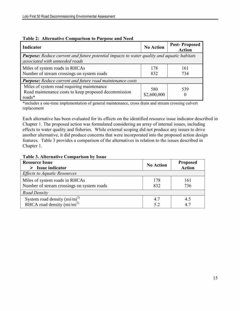
Table 2: Alternative Comparison to Purpose and Need
Indicator No Action Post- Proposed
Action
Purpose: Reduce current and future potential impacts to water quality and aquatic habitats
associated with unneeded roads
Miles of system roads in RHCAs
Number of stream crossings on system roads
178
832
161
734
Purpose: Reduce current and future road maintenance costs
Miles of system road requiring maintenance
Road maintenance costs to keep proposed decommission
roads*
580
$2,600,000
539
0
*includes a one-time implementation of general maintenance, cross drain and stream crossing culvert
replacement
Each alternative has been evaluated for its effects on the identified resource issue indicator described in
Chapter 1. The proposed action was formulated considering an array of internal issues, including
effects to water quality and fisheries. While external scoping did not produce any issues to drive
another alternative, it did produce concerns that were incorporated into the proposed action design
features. Table 3 provides a comparison of the alternatives in relation to the issues described in
Chapter 1.
Table 3. Alternative Comparison by Issue
Resource Issue
Issue indicator No Action
Proposed
Action
Effects to Aquatic Resources
Miles of system roads in RHCAs
Number of stream crossings on system roads
178
832
161
736
Road Density
System road density (mi/mi2)
RHCA road density (mi/mi2)
4.7
5.2
4.5
4.7
Lolo First 50 Road Decommissioning Environmental Assessment
16
CHAPTER 3. AFFECTED ENVIRONMENT AND ENVIRONMENTAL EFFECTS This chapter provides a summary of the affected environment and the environmental impacts of the
alternatives considered in detail.
A. Aquatic Resources
Affected Environment
The analysis area for aquatic resources includes the entire Lolo Creek drainage on Forest managed
lands. The area was selected as it contains all roads proposed for decommissioning and all streams
associated with the roads that might be affected. The following analysis was conducted in combination
with field reviews, Google Earth photo imagery (2013), and mapping in a Geographical Information
System (GIS).
There are 520 miles of streams with a minimum of 22,000 acres of Riparian Habitat Conservation
Areas (RHCAs as designated by PACFISH) in the project area. Timber harvest is generally not
allowed in these areas so that the natural processes for wood recruitment, shade, bank stability, and
habitat development along streams can occur without interruption. There are about 140 miles are fish
bearing and 380 miles that do not contain fish. The drainages where road decommissioning is proposed
include Yakus, Mud, Brick, Upper Lolo, Siberia, Yoosa, Camp, Mox, Gold, Greer Gulch, Alder, and
Dan Lee Creeks (Maps 1 and 2).
Fish surveys indicate annually varying populations of spring chinook salmon and steelhead trout
through the Lolo Creek drainage. The majority of spawning and rearing habitat for these two species
occurs on the mainstem of Lolo Creek between Musselshell and Yoosa Creeks. Chinook salmon are a
Forest Service sensitive species and steelhead trout are listed as threatened under the Endangered
Species Act (ESA). Westslope cutthroat trout occur in moderate to high densities throughout the
drainage and are a sensitive species. They are the only species occurring in the majority of the
Eldorado Creek drainage due to a bedrock falls and cascade barrier 1 mile up from the mouth of the
stream. Bull trout, an ESA threatened species, has been observed rarely in Nez Perce Tribe juvenile
monitoring traps (one or two per year). Western pearlshell mussels, a sensitive species, are known to
occur in Lolo, Eldorado and Musselshell Creeks. No interior redband trout, a sensitive species, are
known to occur in Lolo Creek (May, et al, 2012).
Stream habitat surveys in the 1990s for the various streams show that many of the streams had low
flows, shallow depths, lack of instream cover and pool habitat. They also noted reduced fish habitat
quality resulting from higher than desired sediment levels as measured by cobble embeddedness.
Stream conditions are slowly improving as a result of RHCA retention on all streams (300’ on fish
bearing, 150’ on non-fish bearing perennial, and 100’ on intermittent streams), very little new road
construction, and road improvement and road decommissioning activities. Local monitoring indicates
that sediment from timber harvest units is not reaching streams due to the presence of PACFISH
buffers (Nez Perce-Clearwater NF, unpublished data, 2014). Since 1997 roughly 130 miles of road
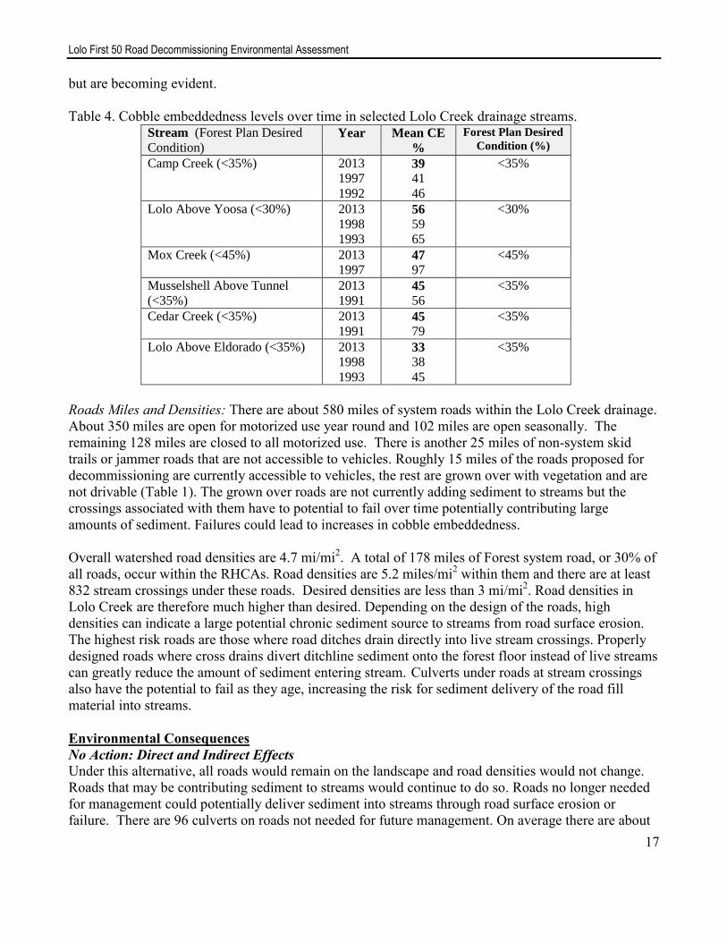
decommissioning has occurred in the Lolo Creek drainage. Recent cobble embeddedness monitoring
data is displayed in Table 4 for various streams in the drainage. Declining trends in sediment are slow
Lolo First 50 Road Decommissioning Environmental Assessment
17
but are becoming evident.
Table 4. Cobble embeddedness levels over time in selected Lolo Creek drainage streams. Stream (Forest Plan Desired
Condition) Year Mean CE
%
Forest Plan Desired
Condition (%)
Camp Creek (<35%) 2013
1997 39
41
<35%
1992 46
Lolo Above Yoosa (<30%) 2013
1998 56
59
<30%
1993 65
Mox Creek (<45%) 2013 47 <45%
1997 97
Musselshell Above Tunnel
(<35%)
2013
1991 45
56
<35%
Cedar Creek (<35%) 2013 45 <35%
1991 79
Lolo Above Eldorado (<35%) 2013
1998 33
38
<35%
1993 45
Roads Miles and Densities: There are about 580 miles of system roads within the Lolo Creek drainage.
About 350 miles are open for motorized use year round and 102 miles are open seasonally. The
remaining 128 miles are closed to all motorized use. There is another 25 miles of non-system skid
trails or jammer roads that are not accessible to vehicles. Roughly 15 miles of the roads proposed for
decommissioning are currently accessible to vehicles, the rest are grown over with vegetation and are
not drivable (Table 1). The grown over roads are not currently adding sediment to streams but the
crossings associated with them have to potential to fail over time potentially contributing large
amounts of sediment. Failures could lead to increases in cobble embeddedness.
Overall watershed road densities are 4.7 mi/mi2. A total of 178 miles of Forest system road, or 30% of
all roads, occur within the RHCAs. Road densities are 5.2 miles/mi2 within them and there are at least
832 stream crossings under these roads. Desired densities are less than 3 mi/mi2. Road densities in
Lolo Creek are therefore much higher than desired. Depending on the design of the roads, high
densities can indicate a large potential chronic sediment source to streams from road surface erosion.
The highest risk roads are those where road ditches drain directly into live stream crossings. Properly
designed roads where cross drains divert ditchline sediment onto the forest floor instead of live streams
can greatly reduce the amount of sediment entering stream. Culverts under roads at stream crossings
also have the potential to fail as they age, increasing the risk for sediment delivery of the road fill
material into streams.
Environmental Consequences
No Action: Direct and Indirect Effects
Under this alternative, all roads would remain on the landscape and road densities would not change.
Roads that may be contributing sediment to streams would continue to do so. Roads no longer needed
for management could potentially deliver sediment into streams through road surface erosion or
failure. There are 96 culverts on roads not needed for future management. On average there are about

Lolo First 50 Road Decommissioning Environmental Assessment
18
100 cubic yards of fill material over each of these culverts for a total of roughly 9,600 cubic yards. The
culvert failure risk is low to moderate in the area; however the risk of failure increases as crossing
structures age. Most metal culverts have a life span of 20-40 years depending on site conditions. The
addition of any or all of the 9,600 yards of material through crossing failures could set back any
sediment recovery that streams have experienced over the last two decades.
Proposed Action: Direct and Indirect Effects
The project would decommission 17 miles of roads within RHCAs. Road decommissioning would
directly add small amounts of sediment into project area streams during stream crossing removal. It
would also disturb existing instream sediments at this time. Best Management Practices would be
incorporated into project design to minimize the amount of new sediment added. BMPs include
dewatering of the site during crossing removal and the placement of sediment catching devices (straw
bales, silt fence) around the work area and in the stream channel. Slash and/or erosion blankets would
be placed on raw re-contoured slopes to minimize erosion on disturbed soils at crossing sites.
Road decommissioning activities would remove 96 perennial stream crossings, three of which are on
cutthroat trout only fish-bearing streams (Mox, Tray, and Brick Creeks). Stream crossing removals
would contribute about 20 pounds of new sediment to streams from each site (Foltz, 2008) for a total
of 1,920 pounds (just under 1 cubic yard). This amount of sediment is considered negligible due to the
highly dispersed area over which activities would occur. It is not expected to be measurable at the
stream or watershed scale. The long term benefit to streams would be the removal of about 9,600 cubic
yards of fill material from over the culverts (average 100 cu yds/crossing) that no longer have the
potential to enter streams since crossing failure potential would be eliminated. The project would result
in a 12% decrease in stream crossings in the drainage.
Project activities would increase turbidity levels when crossings are removed and during spring runoff
the following year. The turbidity is primarily caused by disturbing existing instream sediments during
channel re-contouring and re-watering activities. The sediments and increased turbidity levels will
settle out downstream; the distance is expected to be less than 600’ due to small stream size and low
flow during the summer season when work would occur (Foltz, 2008). Sediment input will occur over
a short time frame (less than 1 day per site). The addition of sediment from work areas just outside the
stream channel would be slight due to the installation of silt fence and straw bales (BMPs) at the work
site. These areas are, however, susceptible to erosion during early heavy fall rains and have been
known to contribute visible amounts of sediment to streams even with BMP implementation (Cedar
Creek culvert replacement, personal observation, 2004). These are relatively uncommon occurrences.
Detecting measurable increases in turbidity would be low during spring runoff due to the difficulty in
separating project-related sediment from naturally occurring sediment during this high flow period.
Project activities would convert a total of eighty-five acres of the RHCAs back into forested conditions
which would provide for current and future woody material input and shade. There would be a 9%
reduction of system roads within RHCAs.
There would be no direct effects to ESA listed steelhead, designated critical habitat for steelhead, or
bull trout since no activities occur at sites occupied by either species. Indirect effects could occur as a
result of increased turbidity downstream, therefore the determination of effects to these species and
steelhead designated critical habitat is “may effect, not likely to adversely affect”. The effects are
expected to be negligible since only 7 of the 96 stream crossing sites are within 600’ of known

Lolo First 50 Road Decommissioning Environmental Assessment
19
steelhead occupation or their designated critical habitat. All occur near the mainstems of Lolo and
Camp Creeks which have wide stream channels and large enough summer flows to dilute any sediment
that enters from the smaller tributaries where the decommissioning activities occur. Only 3 of the
culverts have the potential to add visible sediment to Lolo or Camp Creeks (Road 5136, Road 529) as
the stream flow at the remaining 4 crossings would either be intermittent or so low during removal that
sediment would not travel from the removal site to Lolo or Camp Creeks. The closest culvert that
could add sediment is 380’ from Lolo Creek. There may be a minor turbidity effects on cutthroat trout
in Mox, Tray, and Brick Creeks; however effects are expected to be minimal since the culvert
removals are higher up in these streams where cutthroat densities are low. Direct mortality at these
sites is unlikely due to dewatering of the channel prior to culvert removal. Turbidity increases may
cause cutthroat to temporarily move downstream away from the site. They would move back into the
site once turbidity decreases to acceptable levels, usually within 2 hours of when instream activities
cease. No long term negative effects to the fish are expected. There would be a long-term beneficial
effect to aquatic habitats and species by removing potential sediment sources in and around riparian
areas.
Overall watershed road densities would decrease slightly to 4.5 mi/ mi2 and RHCA road densities
would decrease to 4.7 mi/ mi2. These levels are still well above desired conditions of less than 3
mi/mi2; however for the roads remaining on the landscape and needed for future management, road
improvement activities associated with other projects such as Lochsa Thin and Lolo Insect and Disease
would decrease the effects of roads on streams. Those activities include road surfacing and the addition
of cross drain culverts that would divert road related sediment away from streams.
Cumulative Effects
The cumulative effects analysis area is the Lolo Creek drainage on Forest managed lands. The area
was selected as it contains all roads proposed for decommissioning and all of the streams that may be
affected by them. The timeframe considered is from 2015 to 2022. It starts when road
decommissioning activities would begin and would last 2 years past when they could be completed.
The extra 2 years is added as that is the time it takes for vegetation on decommissioned roads to get
well established and minimize surface erosion from disturbed soils at stream crossings. The activities
considered for cumulative effects include the project-related decommissioning work combined with
the additional 39 miles of decommissioning associated with the Lolo Insect and Disease project. A
total of 15 miles of RHCA road would be removed with an associated 47 crossings under that project.
There are no other past, current, or future foreseeable activities that would affect instream sediment.
Timber harvest is not expected to add sediment to streams based on local monitoring and was therefore
not considered in cumulative effects.
Road decommissioning activities operate within active stream channels which may increase sediment
levels. Each culvert removal site could add 20 pounds of sediment to the stream. There would be a
total of combined total of 143 stream crossings removed as a result of both the Lolo 1st 50 and Lolo
Insect and Disease projects. A total of 2,860 pounds (1 cubic yard or about 1/8th
of a dump truck load)
of sediment could be added to Lolo Creek over the 7 year time frame. The same design features would
be implemented for the decommissioning under Lolo Insect and Disease project in order to minimize
sediment input. Sediment is not expected to be measurable more than 600’ downstream from any
removal or replacement site based on past monitoring of similar activities. The risk of cumulative
effects to instream sediment is considered very low and the effects would be negligible at the

Lolo First 50 Road Decommissioning Environmental Assessment
20
watershed scale.
Cumulatively total system road miles in Lolo Creek would decrease to 500 miles, and RHCA road
miles would decrease from 178 to 146 miles. This is a 16% decrease in watershed and 17% decrease in
RHCA road miles. Watershed road densities would decrease to 4.1 mi/mi2 and RHCA densities would
decrease to 4.2 mi/mi2. Cumulatively 143 stream crossings (17%) would be removed. No non-system
roads would remain after both projects are complete. There would be a positive cumulative effect to
instream sediment as a result of these activities through the removal of potential road crossing failures
and the removal of roads where surface erosion and ditchlines feed directly into streams. Roughly
14,300 cubic yards of fill material would be removed at the crossings.
Consistency with Laws, Regulations and Policies
The proposed activities are consistent with PACFISH in that it conducts watershed restoration
activities that would benefit anadromous fish over the long term. Road decommissioning reduces
potential sediment input through stream crossing removals and the elimination of road failure risk.
The project is also consistent with the Clearwater Forest Plan in that it allows streams to be able to
continue to trend toward meeting desired conditions for cobble embeddedness by reducing the risk for
future input of sediment to streams.
The project complies with the Endangered Species Act in that there would be no adverse effects to
steelhead trout or their designated critical habitat, or to bull trout. There are only 7 sites within 600’ of
known steelhead distribution or designated critical habitat and effects are expected to be negligible in
the short term and beneficial in the long term. Very few bull trout have been observed in the Lolo
drainage. The activities are not expected to directly affect either species and any indirect effects are
expected to be negligible due to design feature implementation that minimizes sediment input to
streams. The project would allow for instream sediment reduction and aquatic habitat improvement
over time.
C. Road Maintenance vs. Decommissioning Costs
Affected Environment
There are 580 miles of Forest managed roads in Lolo Creek. Road maintenance is generally focused on
the 452 miles of roads open year round or seasonally. Only a portion of these roads are maintained
annually depending on budgets and individual road conditions. Maintenance can include all or some of
the following: blading the road surface to maintain drivable conditions, brushing to improve site
distance for safety reasons, rebuilding ditches, adding or replacing cross drain and stream crossing
culverts to maintain proper drainage, or adding new surfacing (rock/ gravel) to the road in order to
maintain drivable conditions. Drainage improvement activities can also help reduce the amount of
sediment added to streams from roads.
Maintenance budgets for Forest roads have decreased by 86% since 2000 while road maintenance costs
have increased by 76%. The ability of the Forest to maintain roads at pre-2000 levels has therefore
become a challenge. With shrinking budgets and increased maintenance costs, the need for

Lolo First 50 Road Decommissioning Environmental Assessment
21
decommissioning roads becomes necessary, especially on roads deemed not needed for future
management.
The cost to conduct general maintenance (pulling ditches, cleaning catch basins, scarifying and
shaping and blading the surface) of 1 mile of average road costs $1,800. The timespan between
blading’s depends on the maintenance level of the road and how much traffic the road receives. More
extensive maintenance can occur and includes cross drain and stream crossing replacements.
Depending on the number of culverts involved, the road maintenance costs would be driven upward.
In general, a typical cross drain culvert costs nearly $2600 to replace every 20-40 years, depending on
site conditions. Typically there are about 10 cross drain culverts per mile of road. When one round of
general maintenance costs are combined with one round of cross drain culvert replacements, the total
cost per mile of maintenance is roughly $27,800.
These costs discussed above do not include stream crossing replacements where culverts can range
from 48” to 10’ in diameter and can cost between $15,000 and $100,000 to replace depending on the
site. The 39 miles of roads proposed for decommissioning contain 96 stream crossings.
The Forest has been decommissioning roads since 1992 and the current cost of road decommissioning
ranges from $4,000 to $10,000 per mile. Roads with deep fills on steep hillslopes tend to cost the most.
Within Lolo Creek, decommissioning so far has ranged between $4,000 and $6,000 per mile. For the
purposes of this analysis, $10,000 per mile is used as it displays the highest expected decommissioning
cost.
Environmental Consequences
No Action: Direct and Indirect Effects
No road decommissioning would occur under this alternative. Road maintenance would occur at some
time on the 41 miles of road. The cost for general maintenance to occur one time on each road would
be $73,800 at today’s costs (41 miles x $1,800/mile). The same costs would be repeated over time as
determined by road conditions; however future costs would be higher due to inflation. Assuming there
are 10 cross drains per mile of road, or 410 pipes total, the cost to replace them all would be about $1.1
million ($410 x $2,600 each). The 96 stream crossings would eventually need to be replaced within the
next 20 years since none have been replaced in the last 20 years. Given an average low cost of $15,000
each, the minimum cost to replace them would be $1.4 million at today’s prices.
The cost of a one-time through general maintenance effort combined with cross drain and stream
crossing replacement on the 41 miles of road would be about $2.6 million.
Proposed Action: Direct and Indirect Effects
The direct cost of decommissioning 41 miles of road would be about $410,000. The removal of these
roads off of the Forest Service road system would indirectly save money as no further dollars would be
spent on maintaining them in the future. This would allow the limited maintenance dollars to be spent
on roads needed for future management (timber harvest, recreation, and administrative use).
Cumulative Effects
There would be positive cumulative effects to the maintenance budget when this project is combined
with the additional 39 miles of road decommissioning proposed under the Lolo Insect and Disease

Lolo First 50 Road Decommissioning Environmental Assessment
22
project. When combined, the 80 miles of decommissioning would eliminate the need to spend about $5
million on road maintenance into the future. Road decommissioning 80 miles would cost about
$800,000 to implement. There would be a positive cumulative effect on the Forest road budget by
removing the need to maintain roads not deemed not needed for future management.
Consistency with Laws, Regulations and Policies
The project is consistent with Forest Plan objectives in that it incorporates transportation planning into
the project area analysis, determines road management needs, such as closures, maintenance, and
decommissioning, and implements a road management program that is responsive to resource
protection needs, water quality goals, and public concerns.
D. Wildlife
This section addresses the effects of road decommissioning on three wildlife species specifically
(western toad, Coeur d’Alene (CDA) salamander and fisher) and other wildlife species in general.
The analysis area for wildlife is the project area because the direct, indirect and cumulative effects of
the project could only occur in these areas. The anticipated effects would occur in relatively small
areas compared to the larger extent of habitats surrounding each of the roads.
Affected Environment
There are 452 miles of road open to some form of vehicular use during the year and 128 miles of
closed roads. There are about 5 acres of land associated with each mile of road therefore the total
amount of land occupied by roads is roughly 2,900 acres, or 4% of Forest lands in Lolo Creek.
Roads can fragment forested stands and therefore wildlife habitat. Roads open to vehicle use have the
greatest potential to affect wildlife due to a lack both cover and foraging habitat. These roads also have
the highest risk for human/wildlife contact which can lead to the disturbance and direct mortality of
wildlife. Open roads make it easier for hunters and trappers to access preferred habitat for larger game
species such as elk, deer, marten, bear, cougars and furbearers. These activities occur mostly in the fall
and winter seasons. Wildlife disturbance can occur during any time of the year. Direct collisions with
vehicles are a more common cause of mortality for the smaller animals such as amphibians, reptiles,
and birds (Switalski, 2004) but have little bearing on larger game species.
Roads that are closed to vehicle use and have not been maintained tend to grow over with grasses,
mosses, and if old enough, small trees. They also can have a small downed wood component as trees
surrounding them die and fall. These roads mostly provide wildlife species with cover and travel
corridors and may provide foraging habitat for some species. Forage is limited however due to the
compacted condition of the road surface which does not allow for the development of deep plant roots.
This, in turn, limits the amount and types of native vegetation, and potential forage that can grow on
the roads. Signs of those most commonly seen species using closed road are bear, moose, coyote, deer
and elk.
Of the 41 miles of road proposed for decommissioning, 26 miles are currently drivable. A total of 15
miles are not drivable and could provide cover or minimal amounts of habitat for wildlife species.
Lolo First 50 Road Decommissioning Environmental Assessment
23
The project area provides habitat for fisher, more so during the winter than in the summer months.
Fisher were detected in the project area during summer of 2013.
Streams may provide habitat for CDA salamanders though none have been documented in the project
area. Western toads are likely to occur within the project area but densities are unknown.
Environmental Effects
No Action: Direct and Indirect Effect
There would be continued direct mortality effects to small animals through direct collisions with
vehicles on drivable roads. The indirect disturbance and mortality effects from easy access into
preferred habitats for game species would also continue, primarily on open roads, especially during the
fall and winter months.
Wildlife species would continue to use closed roads for travel corridors, cover habitat, and some
foraging where it is available. Snags and downed woody material used by amphibians and other small
animals would generally be lacking on these roads. These roads are not expected to develop into
quality wildlife habitat that contains wood, native vegetation, snags or large trees due to the compacted
road surface.
Proposed Action: Direct and Indirect Effects
Road decommissioning may negatively affect wildlife species through noise-associated disturbance,
potential habitat loss, or direct mortality of individuals, especially small mammals, reptiles, or
amphibians. This is most likely to occur on the 15 miles of currently not drivable roads as they have
the greatest likelihood of being used by wildlife. The effects of activities on all 41 miles of road are
expected to be isolated and would occur over about 200 acres of land, or 0.2% of Forest managed lands
in Lolo Creek.
The CDA salamander and western toad may be impacted by the project since decommissioning would
occur at stream crossings, and in riparian or moist areas where suitable habitat for these species may
occur. Noise and human activity may disturb a fisher but it would be of short duration and only during
the daylight hours. Proposed activities therefore May adversely Impact Individuals or their Habitats,
but is not likely to result in a loss of viability or cause a trend to federal listing to Coeur d’ Alene
salamander, western toad and fisher. Road decommissioning would create beneficial effects to
sensitive species by reducing sedimentation and allowing natural vegetation and root systems to re-
establish habitat on a once compacted surface. The new vegetation would offer habitat for invertebrate
species: a food source for salamanders and toads. Recontoured road prisms would provide more
contiguous habitat for fisher with less opportunity for human disturbance.
Roads currently open to vehicle use would be removed and access would be prevented which would
eliminate direct wildlife disturbance and morality. Indirectly vegetation would be reestablished where
roads previously existed and forests would grow in their place. The components necessary for quality
wildlife habitat would eventually become available, including a diversity of tree and shrub species as
well as snags and downed woody material. Design features would require the placement of large
woody material on the decommissioned road surface in order to provide some habitat for species and
to provide soil nutrients over time.

Lolo First 50 Road Decommissioning Environmental Assessment
24
Wildlife cover habitat would be removed as a result of decommissioning and would not be available
for about 20 years. This is about the length of time it would take for trees and vegetation to become tall
enough to hide the larger species such as elk, deer, and moose. Forage would become available as
roads become grown in, generally within 10 year for some species such as bears (Switalski, 2010).
There would be ample habitat for wildlife to disperse into that lies directly adjacent to decommissioned
roads.
The removal of roads would reduce easy access to some hunting and trapping areas. These activities
would still occur along some of the decommissioned roads; however access could only be by foot or
stock. Overall, the amount of human-wildlife interactions would decrease as a result of
decommissioning.
Cumulative Effects
There would be minor negative and positive cumulative effects to wildlife when this project is
combined with the additional 39 miles of road decommissioning proposed under the Lolo Insect and
Disease project. The direct and indirect effects would be same as those described above over and
additional 195 acres of land. When combined, the 80 miles of decommissioning would increase
available wildlife habitat by 395 acres over time. It would reduce human-wildlife interactions by
preventing vehicle access on these areas. Access by foot or stock would become more difficult which
would also limit wildlife disturbance by humans.
CHAPTER 4. Regulatory Framework and Consistency The Lolo First 50 Road Decommissioning Project analysis and documentation of effects is consistent
with direction described below.
Forest Plan Direction
The Clearwater National Forest Plan (CFP), as amended, guides all natural resource management
activities by providing a foundation and framework of standards and guidelines for National Forest
system lands administered by the Clearwater National Forest. Forestwide management direction
relevant to this project is found in the CFP on pages II-1 through II-40. Applicable goals and standards
are summarized below.
Locate, design and manage Forest roads to meet resource objectives and public concerns, and
to provide optimal soil and watershed protection.
Plan, construct and maintain a safe and cost-efficient Forest transportation system that will
achieve Forest Plan resource management goals and objectives.
Review existing system and nonsystem roads as part of transportation planning to determine
road management needs, such as, closures, maintenance and obliteration.
Area specific standards and guidelines are found on pages III-1 through III-74 of the CFP. Most of the
project area lies within Management Area E1, timber management, with inclusions of M2, Riparian
Habitat Conservation areas. Management direction specific to the Lolo First 50 Road

Lolo First 50 Road Decommissioning Environmental Assessment
25
Decommissioning Project is summarized below:
Management Area E1 – Timber Management
Design and develop road systems in accordance with area transportation plan procedures.
Regulate use of roads and trails (to motorized vehicles) where needed to accomplish wildlife,
watershed objectives, or property values.
Clearwater Forest Plan Water Quality Standards
Water quality standards in the CFP on pages II-27 through II-29 direct that soil and water resources be
managed at levels designed to meet Forest management objectives for watersheds as well as meet
Idaho State Water Quality Standards. The Forest Plan requires projects to:
Manage water quality and stream conditions to assure that National Forest management
activities do not cause permanent or long-term damage to existing or specified beneficial uses.
Apply best management practices (BMP) to project activities to ensure water quality standards
are met or are exceeded.
Manage all waters in the Forest according to the standards listed in Appendix K of the Forest
Plan. The standards and desired conditions are based on instream sediment levels. The project
would move towards meeting the desired conditions as potential sediment sources from roads
would be removed.
The project complies with all Forest Plan standards and guidelines. It removes roads no longer needed
for management which in has positive effects on fish and wildlife species, including Management
Indicator and Sensitive Species. Decommissioned roads provide forested habitat over time and reduce
road related sediment input to streams while maintaining access to harvestable timber stands in
management areas designated for timber harvest. BMPs would be used to minimize effects to aquatic
species during project implementation. Applying BMPs would also help to meet both State and Forest
Plan water quality standards.
PACFISH: On February 25, 1995, the Forest Service and Bureau of Land Management issued a
decision for managing anadromous fish-producing watersheds on federal lands (USDA Forest Service,
1995), which was amended to the Forest Plan. PACFISH standards and guidelines for this project are
generally related to managing roads, design features and mitigation measures such that they do not
retard or prevent attainment of Riparian Management Objectives. Riparian Management Objectives
(RMOs) for “forested streams” include the following stream habitat variables: bank stability, pool
frequency (pools per mile), water temperature, large woody debris and width/depth ratio. The project
has been designed to have a long term benefit to these objectives through road removal in Riparian
Habitat Conservation Areas. Decommissioning returns stream channels to their natural size and shape
and allows for the regrowth of forests around streams and across the landscape. Forests provide shade,
large woody material and bank stability to streams. The project is therefore consistent with PACFISH.
Watershed and Fisheries Resources Regulatory Framework
All Federal and State laws and regulations applicable to water quality would be applied to this road
decommissioning project, including 36 CFR 219.27, the Clean Water Act, and Idaho State Water
Quality Standards, Idaho Forest Practices Act, Idaho Stream Channel Protection Act, and Best
Management Practices (BMP’s). In addition, laws and regulations require the maintenance of viable

Lolo First 50 Road Decommissioning Environmental Assessment
26
populations of aquatic species including the National Forest Management Act (36 CFR 219.19),
subsequent Forest Service direction (Fish and Wildlife Policy, 9500-4) and Forest Service manual
direction (FSM 2470, 2600). The Idaho Department of Environmental Quality identifies beneficial
uses for Lolo Creek and tributaries as cold water aquatic life, salmonid spawning and secondary
contact recreation (IDEQ, 2011). Current status for all uses is fully supported for Lolo Creek and the
majority of its tributaries. The project would help to maintain the streams beneficial uses. Eldorado,
Jim Brown, and Musselshell Creeks are listed as impaired for stream temperature. The project would
help to maintain or improve stream temperature over time as roads are converted back to forest,
particularly at stream crossings.
Endangered Species Act The proposed actions comply with the Endangered Species Act. A biological assessment and
evaluation were completed for this project. The biological assessment determined that the project
“may effect, not likely to adversely affect” steelhead or their designated critical habitat, bull trout, or
Canada lynx. There would be “no effect” to fall chinook salmon. The project is “not likely to
jeopardize the continued existence of the wolverine. See the Biological Assessment in the project file.
National Historic Preservation Act of 1966, as amended
A heritage resource investigation was conducted. Any properties eligible or potentially eligible for
listing in the National Register of Historic Places would be protected. One site was identified and any
disturbance around it would be avoided.
Other Required Analysis This is not a major Federal action. It will have limited context and intensity (40 CFR 1508.27),
individually or cumulatively, to the biological, physical, social or economic components of the human
environment. It will have no adverse effect upon public health or safety, consumers, civil rights,
minority groups and women, prime farm land, rangeland and forestland, roadless areas, or to old
growth forest options.
A. Effects of Alternatives on Prime Farm land, Rangeland, and Forest land
All alternatives are in keeping with the Secretary of Agriculture memorandum, 1827 for prime land.
The analysis area does not contain any prime farm lands or range lands. “Prime” forest land does not
apply to lands within the National Forest system. With both alternatives, National Forest lands would
be managed with sensitivity to the effects on adjacent lands.
B. Energy Requirements of Alternatives
There are no unusual energy requirements for implementing any alternative.
C. Effects of Alternatives on Minorities and Women
There are no unusual differences among the effects of any alternative on American Indians, women,
other minorities, or the civil rights of any American citizen.

Lolo First 50 Road Decommissioning Environmental Assessment
27
D. Environmental Justice
In regard to Environmental Justice Order 12898, the health and environmental effects of the proposed
activities would not disproportionately impact minority and low-income populations. There would be
no effect from the proposed activities on the treaty rights of the Nez Perce Tribe and local
communities.
E. List of Preparers
Interdisciplinary Team Members
Karen Smith, Team Leader and Fisheries Biologist
Glen Gill, Wildlife Biologist
Stephan Frazier, Engineer
Megan Lucas, Hydrologist
Pat Bower, Heritage Resources
Cindy Schacher, Heritage Resources

Lolo First 50 Road Decommissioning Environmental Assessment
28
Appendix A. References Foltz, R. B., K A. Yanosek, and T. M. Brown. 2008. Sediment concentration and turbidity changes
during culvert removals. Journal of Environmental Management 87 (2008) 329-240.
Idaho Department of Environmental Quality (IDEQ). 2011. Idaho 2010 Integrated Report (303d/305b
list). IDEQ, Boise, Idaho. Available at: http://www.deq.state.id.us/water-quality/surface-
water/monitoring-assessment/integrated-report.aspx#2010-IR
May, Bruce E., B. J. Writer and S. Albeke, 2012. Redband Trout Status Update Summary. Wild Trout
Enterprises, LLC. Bozeman, MT.
Switalski, T.A., 2010. Monitoring of Wildlife Habitat Restoration on the Clearwater National Forest.
Wildlands CPR. Missoula, MT.
Switalski, T.A., J.A. Bissonette, T. H. DeLuca, C.H. Luce,and M.A. Madej. 2004. Benefits and
impacts of road removal. Front Ecol Environ 2004; 2(1): 21-28. The Ecological Society of America.
www. frontiersinecology.org.
USDA. Forest Service. September 1987. Forest Plan, Clearwater National Forest. U.S.D.A. Forest
Service. Orofino, Idaho.
USDA Forest Service, Nez Perce-Clearwater NF, unpublished data, 2014. PACFISH buffer monitoring
data on the Lochsa District, Kooskia, ID.