Embed Size (px)
Citation preview

20 AUGUST 2021
PREPARED FOR PROPERTY NSW
MOONEY MOONEY AND PEAT ISLAND LOCATION SPECIFIC DCP
DRAFT FOR COUNCIL
© Urbis Pty Ltd
ABN 50 105 256 228
All Rights Reserved. No material may be reproduced without prior permission.
You must read the important disclaimer appearing within the body of this report.
urbis.com.au
URBIS STAFF RESPONSIBLE FOR THIS REPORT WERE:
Director Madonna Locke; Sarah Horsfield Senior Consultant Anna Wang Consultant Agnes Tiong Project Code P0034467 Report Number 3 Date 20 August 2021 Status FINAL

DRAFT FOR COUNCIL
URBIS RPT_MOONEY MOONEY DCP 2021
TABLE OF CONTENTS
1. Introduction ....................................................................................................................................... 1 1.1. Land to which this Chapter Applies ..................................................................................... 1 1.2. Purpose of this Chapter ....................................................................................................... 1 1.3. Relationship to Other Plans ................................................................................................. 1 1.4. Vision for Mooney Mooney & Peat Island ............................................................................ 3 1.5. Objectives ............................................................................................................................ 3
2. Precincts and Character Statements .............................................................................................. 5 Peat Island (Tourist Zone) ................................................................................................... 5 Waterside Village ................................................................................................................. 5 Northern Foreshore Precinct ............................................................................................... 5 Southern Foreshore Precinct ............................................................................................... 5 Mooney Mooney Village ...................................................................................................... 5 Chapel Residential Precinct ................................................................................................. 6 Proposed Sub-Station Site .................................................................................................. 6
3. Heritage Values and Conservation Management ........................................................................... 8 3.1. Statement of Heritage Significance ..................................................................................... 8 3.2. Objectives ............................................................................................................................ 9 3.3. Controls .............................................................................................................................. 10
3.3.1. Aboriginal Cultural Heritage & Archaeology ....................................................... 10 3.3.2. Built (European) Heritage Gradings of Significance ........................................... 10 3.3.3. Built (European) Heritage Management ............................................................. 13 3.3.4. Heritage Reporting Requirements for Development Applications ...................... 14 3.3.5. Significant Landscape Elements, Views and Vistas ........................................... 14
4. Environmental Management .......................................................................................................... 19 4.1. Objectives .......................................................................................................................... 19 4.2. Controls .............................................................................................................................. 19
4.2.1. Vegetated Riparian Zone ................................................................................... 19 4.2.2. Vegetation Retention, Planting and Management .............................................. 19 4.2.3. Asset Protection Zone (APZ) .............................................................................. 23 4.2.4. Flood Planning .................................................................................................... 25 4.2.5. Stormwater Quality Management ....................................................................... 28
5. Public Open Space .......................................................................................................................... 30 5.1. Objectives .......................................................................................................................... 30 5.2. Controls .............................................................................................................................. 30
6. Access and Parking ........................................................................................................................ 32 6.1. Street Network, Access and Parking ................................................................................. 32
6.1.1. Objectives ........................................................................................................... 32 6.1.2. Controls .............................................................................................................. 32
6.2. Pedestrian and Cycle Network .......................................................................................... 34 6.2.1. Objectives ........................................................................................................... 34 6.2.2. Controls .............................................................................................................. 34
7. Built Form Guidance for New Buildings in Heritage Precincts .................................................. 36 7.1. Objectives .......................................................................................................................... 36 7.2. Controls .............................................................................................................................. 36
8. Built Form Guidelines for Residential Developments ................................................................. 40 8.1. Objectives .......................................................................................................................... 40 8.2. Controls .............................................................................................................................. 40
8.2.1. Front and Rear Setback Controls by Precincts .................................................. 42 8.2.2. Acoustic Treatments for Residential Developments located along Pacific
Highway .............................................................................................................. 49
Disclaimer ........................................................................................................................................................ 51

DRAFT FOR COUNCIL
URBIS RPT_MOONEY MOONEY DCP 2021
TABLES:
Table 1 Precinct Gradings of Significance ...................................................................................................... 10 Table 2 Individual Elements Grading of Significance Criteria ......................................................................... 13 Table 3 Significant Views & Vistas .................................................................................................................. 15 Table 4 Recommended Species for New Plantings ........................................................................................ 20 Table 5 Flood Planning Level for Habitable and Non-Habitable Buildings at Mooney Mooney and Peat Island ............................................................................................................................................................... 25 Table 6 Water Quality Targets ........................................................................................................................ 28 Table 7 Minimum Setback Controls ................................................................................................................ 42
FIGURES:
Figure 1 Mooney Mooney and Peat Island Site Plan ....................................................................................... 2 Figure 2 Mooney Mooney & Peat Island Indicative Concept Plan ................................................................... 4 Figure 3 Mooney Mooney & Peat Island Precinct Plan .................................................................................... 7 Figure 4 Peat Island and Mooney Mooney Overall Precinct Gradings of Significance .................................. 11 Figure 5 Peat Island and Mooney Mooney Individual Element Gradings of Significance .............................. 12 Figure 6 Heritage Significance Map ................................................................................................................ 18 Figure 7 Vegetated Riparian Zone .................................................................................................................. 21 Figure 8 Vegetation Retention Plan ................................................................................................................ 22 Figure 9 Asset Protection Zone ...................................................................................................................... 24 Figure 10 Flood Planning Level ...................................................................................................................... 26 Figure 11 Indicative Flood Emergency Plan ................................................................................................... 27 Figure 12 Water Quality Strategy ................................................................................................................... 29 Figure 13 Public Open Space ......................................................................................................................... 31 Figure 14 Road Hierarchy and Vehicle Movement Plan ................................................................................. 33 Figure 15 Pedestrian and Cycle Movement Plan ........................................................................................... 35 Figure 16 Peat Island Precinct Plan ............................................................................................................... 37 Figure 17 Chapel Precinct Plan ...................................................................................................................... 39 Figure 18 Overall Subdivision Layout Plan ..................................................................................................... 41 Figure 19 Chapel Residential Precinct Plan ................................................................................................... 43 Figure 20 Waterside Village Plan ................................................................................................................... 45 Figure 21 Mooney Mooney Village Plan ......................................................................................................... 46 Figure 22 Northern Foreshore Precinct Plan .................................................................................................. 47 Figure 23 Southern Foreshore Precinct Plan ................................................................................................. 48 Figure 24 Acoustic Treatment ......................................................................................................................... 50

DRAFT FOR COUNCIL
URBIS RPT_MOONEY MOONEY DCP 2021 1
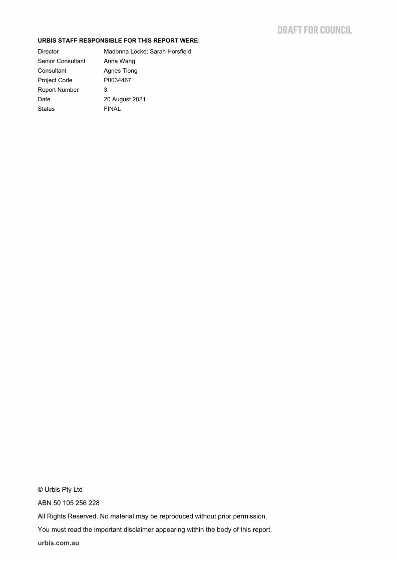
1. INTRODUCTION 1.1. LAND TO WHICH THIS CHAPTER APPLIES This Chapter applies to land at Mooney Mooney and Peat Island (the site) as shown in Figure 1. The site is located on the northern banks of the Hawkesbury River, and is the gateway to Central Coast.
The site is bound by the Hawkesbury River on the southern, eastern and western boundaries, Popran National Park to the north western side of the M1 Pacific Motorway (M1) and the existing residential community on the north eastern side of the M1.
1.2. PURPOSE OF THIS CHAPTER This Chapter provides detailed guidance for development applications (DAs) related to the land to which this plan applies. This chapter supplements the provisions of the Central Coast Local Environmental Plan 2018 (Central Coast LEP 2018) and includes site specific objectives and controls within the site.
1.3. RELATIONSHIP TO OTHER PLANS The Chapter supplements the provisions of the Central Coast LEP 2018. If there is any inconsistency between this chapter and the LEP, the LEP prevails.
The relevant sections of the Central Coast Development Control Plan 2018 and adopted Council policies, and codes of Central Coast Council also apply to the site, notably:
Civil Works Specification Design Guideline 2018
Water Cycle Management Guidelines
Central Coast Council Flora and Fauna Guidelines
This Chapter is to be read in conjunction with Central Coast DCP 2018, notably:
Part 1 – Preliminary
Part 2 – Development Provisions
Part 3 – Environmental Controls
Where it conflicts with other requirements of the Central Coast DCP 2018, this Chapter prevails.
State Environmental Planning Policies may apply to the land to which this Chapter applies.
A Microbat Management Plan September 2020 (prepared by Ecological) also applies to areas where microbat’s habitat were identified. Please refer to Figure 1: Locations of buildings containing roosting habitat and locations of threatened bats detected in the Microbat Management Plan for location details.
DRAFT FOR COUNCIL
2 URBIS RPT_MOONEY MOONEY DCP 2021
Figure 1 Mooney Mooney and Peat Island Site Plan
DRAFT FOR COUNCIL
URBIS RPT_MOONEY MOONEY DCP 2021 3
1.4. VISION FOR MOONEY MOONEY & PEAT ISLAND The vision for Mooney Mooney and Peat Island is:
A mixed-use community nestled into its scenic natural setting on a peninsula of the Hawkesbury River. As the gateway to the central coast, the redevelopment sensitively integrates the historically significant Peat Island and surrounding land into the existing Mooney Mooney neighbourhood. It provides a diverse mix of housing options, as well as new tourism and visitor facilities which provide employment opportunities for locals. Waterfront parklands, restored heritage buildings and dedicated conservation areas connect residents to nature and the history of the site.
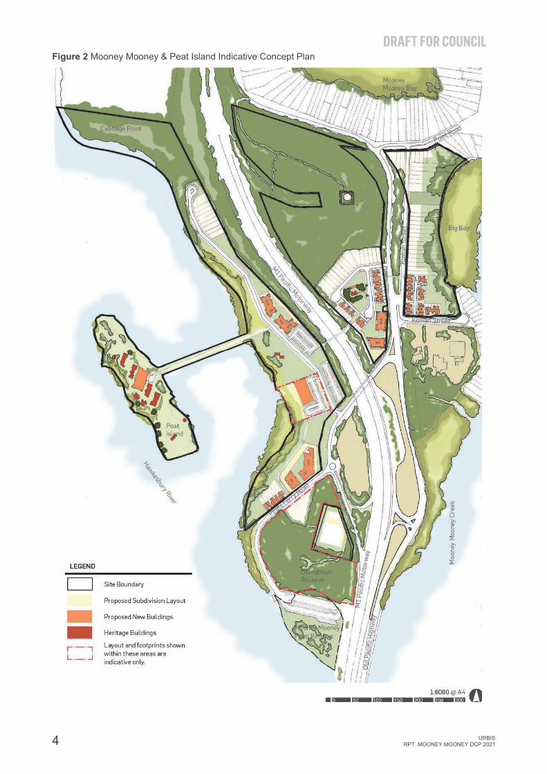
The Indicative Concept Plan shown in Figure 2 provides an illustration of the potential development outcome for Mooney Mooney and Peat Island. The intention of this plan is to convey the character and indicative development outcomes that may occur under the Central Coast LEP 2018. It does not represent the only scenario for the site, nor should it be used to limit alternative scenarios that may be consistent with the objectives and development standards of the Central Coast LEP 2018.
1.5. OBJECTIVES The objectives of this Chapter are:
Facilitate the future redevelopment of the site for a mix of residential, community, tourism and employment generating land uses.
Establish overarching design principles and controls for the infill development of Mooney Mooney and Peat Island which respond to the natural setting and local character of the site.
Deliver a range of dwelling options across the different character precincts which provide greater housing choice and diversity.
Provide new open space areas which allow for a mix of local recreational activities that maximise waterfront access.
Adaptively reuse heritage buildings to allow the local and wider community to engage with the cultural significance of the site.
Provide guidance on the integration of residential development with employment generating land uses such as local neighbourhood shops, cafes and tourism.
Allow for efficient and safe movement of traffic and all modes of transport including pedestrians and cyclists to, from and within the site.
Enhance access to local convenience facilities and services through the provision of local neighbourhood shops.
Guide development to minimise impacts to the environment, and ensure development is planned in a way that enhances the natural environment and cultural significance of the site.
DRAFT FOR COUNCIL
4 URBIS RPT_MOONEY MOONEY DCP 2021
Figure 2 Mooney Mooney & Peat Island Indicative Concept Plan

DRAFT FOR COUNCIL
URBIS RPT_MOONEY MOONEY DCP 2021 5
2. PRECINCTS AND CHARACTER STATEMENTS The following provides character statements for each of the precincts identified within the site as shown on Figure 3 and are to be considered in the preparation and assessment of development applications:
Peat Island (Tourist Zone) Peat Island is a distinctive accommodation destination set within a waterfront landscape setting. The adaptive re-use of existing heritage buildings and the development of a new central building to accommodate short-term accommodation along with associated restaurants, cafes, entertainment facilities, function spaces and tourist recreational uses will activate the Island and encourage exploration of the foreshore promenade.
Given the heritage significance of Peat Island, the following desired future character has been established for the future adaptive reuse of the island:
Conservation of the heritage significance of Peat Island through the retention and adaptive re-use of nine (9) buildings with identified heritage significance on Peat Island.
Two (2) buildings with little heritage significance are identified for adaptive reuse on the Mooney Mooney Foreshore to support future tourism uses on Peat Island.
New buildings and structures within this precinct are to have regard to the scale and form of the retained buildings as well as the existing topography and visual context of the island.
Use of the precinct for tourism and employment generating uses including visitor accommodation and associated restaurants, café’s, recreation facilities (tennis courts, kayak hire), camping grounds and conference type facilities must complement and enhance the existing character.
Provide a network of open space on this former institutional site, including access to the western foreshore areas and Peat Island for public use and enjoyment; and
Provision of continuous and high-quality shared pathways around the perimeter of Peat Island and along the river foreshore.
Waterside Village The Waterside Village is a mixed-use waterfront village located on the western foreshore. Nestled between Peat Island and the M1, it comprises generous foreshore parkland, which creates a focal point for the community and a gateway to Peat Island. The precinct also comprises low rise apartments, public parking and a linear foreshore parkland on the Hawkesbury River.
Northern Foreshore Precinct The Northern Foreshore Precinct comprises compact detached residential housing at the north-western extent of the Mooney Mooney Peninsula. The housing is sensitively set within a waterfront landscape setting and is well connected to the Waterside Village Precinct via the foreshore parkland areas and waterfront pathway.
Southern Foreshore Precinct The Southern Foreshore Precinct provides compact and diverse housing on the waterfront, including shop top housing with retail use on the ground floor and townhouses fronting Peats Ferry Road.
Mooney Mooney Village Mooney Mooney Village is a new mixed-residential precinct on the eastern side of Mooney Mooney, sitting alongside and complimenting the existing residential community. The precinct transitions from single detached dwellings with spacious backyards extending to the waterfront in keeping with the established suburban landscape character and setting of Mooney Mooney in the north through to compact townhouses at the southern end of the precinct providing housing diversity in this location.

DRAFT FOR COUNCIL
6 URBIS RPT_MOONEY MOONEY DCP 2021
Chapel Residential Precinct The Chapel Residential Precinct is a mixed-residential precinct including shop top housing with retail use centred around the adaptive re-use of the existing chapel. The Chapel will be adaptively reused and complemented with a new community facility building to create an indoor-outdoor community hub set within a new parkland at the heart of the neighbourhood.
Proposed Sub-Station Site The Sub-Station Site is identified to accommodate a potential new sub-station to provide reliable power source for future development. The preferred location is subject to detailed investigations by Ausgrid.

DRAFT FOR COUNCIL
URBIS RPT_MOONEY MOONEY DCP 2021 PRECINCTS AND CHARACTER STATEMENTS 7
Figure 3 Mooney Mooney & Peat Island Precinct Plan

DRAFT FOR COUNCIL
8 HERITAGE VALUES AND CONSERVATION MANAGEMENT URBIS RPT_MOONEY MOONEY DCP 2021
3. HERITAGE VALUES AND CONSERVATION MANAGEMENT
The Peat Island and Mooney Mooney site (identified as the former Peat Island Centre in the CMP) has significance for its Aboriginal and European cultural heritage values. These heritage values are founded in the site’s rich history as an important cultural place within the Hawkesbury River catchment to the local Aboriginal community, and the later use of the place for a purpose-built government institution for the care of the mentally ill. These cultural heritage values collectively contribute to the community’s sense of place and identity.
This section applies to the management of the cultural heritage values of the place including:
Aboriginal cultural heritage and archaeology;
Historical Archaeology;
Built (European) and landscape elements of heritage significance; and
Significant views.
The objectives, requirements and controls in this section are to be read in conjunction with the following:
Section 7 Built form guidance for New Buildings in Heritage Precincts and Section 8 Built Form Guidelines for Residential Developments of this chapter:
Heritage conservation requirements of Central Coast LEP 2018;
Chapter 3.6 Heritage Conservation of Central Coast DCP 2018;
Peat Island Conservation Management Plan (Urbis 2020); and
Aboriginal Cultural Heritage Management Plan Assessment for Peat Island and Mooney Mooney (Extent 2020).
3.1. STATEMENT OF HERITAGE SIGNIFICANCE Aboriginal Cultural Heritage
Peat Island, the adjacent mainland and associated foreshore areas have been identified as having high Aboriginal cultural heritage value and high potential for Aboriginal archaeology. The precinct contains a number of registered Aboriginal sites including rock engravings and grinding grooves associated with Aboriginal occupation along the Hawkesbury River.
European (Built Heritage) and Landscape Significance
The Peat Island precinct has heritage significance at the state level for its historic, associative, aesthetic, rarity and representative values.
The subject site has significance for its historical uses, firstly as a purpose-built government institution for the treatment and management of inebriates – a use which was never realised – and its revised use as a government institution for the management and care of mentally ill patients. The development of Peat Island for this institutional facility use demonstrates the changing attitudes towards the care of the mentally ill and addicts in the early twentieth century and the governmental response to management of these people.
The existing buildings on the Island dating from c.1900-1910 demonstrate the early twentieth century architectural response to the development of institutional ward buildings and are associated with Government Architects Walter Liberty Vernon and George McRae. These early buildings are substantially intact despite later minor alterations and directly contribute to the historical and aesthetic values of the place.
The development of the institutional facility within a picturesque setting high on a promontory in the Hawkesbury River with unobstructed water views, together with the provision of outdoor therapy including swimming pools, playing fields and gardening programs, is representative of the shift in attitudes towards the care of mentally ill patients from the mid nineteenth century onwards. The Peat Island facility, including its location, early buildings and approach to planned landscaping, is representative of the importance of nature,

DRAFT FOR COUNCIL
URBIS RPT_MOONEY MOONEY DCP 2021 HERITAGE VALUES AND CONSERVATION MANAGEMENT 9
landscaping, fresh air and scenic vistas which underpinned the philosophy regarding the treatment of mentally ill patients.
The development of Peat Island as an isolated land body within the Hawkesbury is rare in the context of government built institutional facilities as its isolation and difficult access directly supported the intended use and function of the facility. Other examples of government institutions developed around the same period are all located on the mainland and had to control access and manage patients.
Later areas of development along the Mooney Mooney foreshore associated with the operations of the facility have a contributory but overall lower level of significance to the precinct in comparison to the principal Peat Island development. These areas are restricted to ancillary buildings and facilities to support the overall operations of the institution. The Chapel and associated memorial gardens are likely to have a level of significance to the local community and former patients and staff of the institution.
3.2. OBJECTIVES Aboriginal Cultural Heritage & Archaeology
Avoidance of works in and around the locations of identified archaeological sites and Aboriginal site complexes to minimise potential for impacts.
Minimise potential impacts to potential aboriginal cultural heritage sites through avoidance and/or minimisation of ground disturbance in areas of moderate, high and very high archaeological potential.
Understand the aboriginal cultural heritage significance and potential of the place.
Protect and interpret archaeological remains.
Historical Archaeology
Understand the historical archaeological significance and potential of the place.
Avoid adverse impacts of potential historical archaeological remains.
Protect and interpret potential historical archaeological remains.
Built (European) Heritage
Understand, interpret and celebrate the rich history and heritage significance of Peat Island.
Conserve existing buildings, structures, spaces and landscape of heritage significance.
Encourage the adaptive reuse of the existing buildings and structures of heritage significance to facilitate new uses and encourage occupation of the place.
Provide for new development which is complementary to and supports the ongoing conservation of the place.
Explore new uses which allow for public access to Peat Island to encourage interpretation and celebration of the history of the place.
Landscape Elements, Views and Vistas
Retain, enhance and interpret the landscape, visual setting and scenic qualities of Peat Island, the visual connection between Peat Island and the Hawkesbury River, and between Peat Island and the western Mooney Mooney foreshore.
Allow for new development on or in the vicinity of Peat Island that retains and enhances the landscape setting of the place, and does not detract from or obscure the landscape, and visual and scenic setting of Peat Island.

DRAFT FOR COUNCIL
10 HERITAGE VALUES AND CONSERVATION MANAGEMENT URBIS RPT_MOONEY MOONEY DCP 2021
3.3. CONTROLS 3.3.1. Aboriginal Cultural Heritage & Archaeology Aboriginal heritage sites identified within the locality (refer to Figure 6) have been classified into two categories, with management recommendations for each zone:
Identified Aboriginal Sites:
‒ Identified Aboriginal sites are of high cultural and scientific significance. Development activities within, or in proximity to them must be avoided. Strategies for management are to be developed during Development Application (DA) stage, through the preparation of suitable heritage assessment and/or planning document (e.g. Conservation Management Plan (CMP) or Plans of Management), and their implementation.
‒ Works of any kind, including geotechnical testing and other environmental investigations, are not permissible in the vicinity of Identified Aboriginal Sites or their identified site boundaries, without first obtaining an Aboriginal Heritage Impact Permit from the NSW Department of Premier and Cabinet. Appropriate assessments in accordance with the requisite standards and guidelines are to be adopted in Potential Aboriginal Sites.
‒ Where Aboriginal sites are identified but would remain unaffected by the proposed development, appropriate management plans are to be developed at the DA assessment phase. This would ensure their conservation and management into the future as development progresses and visitation increases around them.
Potential Aboriginal Sites:
‒ Where development impact would occur within sites with potential Aboriginal significance, an Aboriginal Cultural Heritage Assessment (ACHA) is required to be prepared in accordance with Office of Environment and Heritage (OEH) standards and guidelines, and with further investigation in the form of archaeological test excavation being implemented, prior to lodgement of relevant DA(s).
‒ It is recommended that a requirement for Aboriginal archaeological test excavation in areas of archaeological potential, subject to development impact, be incorporated into any Concept Plan General Terms of Approval (GTAs) (or equivalent). This will ensure that the potential Aboriginal heritage impact of the proposed development is appropriately investigated, assessed and managed in the future.
3.3.2. Built (European) Heritage Gradings of Significance A Conservation Management Plan (CMP) has been prepared by Urbis (2020) for Peat Island and Mooney Mooney to provide a considered analysis of the heritage significance of the place and policies and guidance to assist owners and users to appropriately manage this significance into the future.
The CMP assesses the existing individual built and landscape elements on the site and provides a relative contributory grading of significance for each element with consideration for the collective significance of the former Peat Island Centre. The gradings of significance contain 6 categories from Exceptional Significance to Intrusive.
The overall precinct gradings for the site are listed in the table below and identified in Figure 4.
Table 1 Precinct Gradings of Significance
ELEMENT GRADING OF SIGNIFICANCE
Heritage Precinct A: Peat Island and Causeway High
Heritage Precinct B: Mooney Mooney Foreshore Precinct Moderate
Heritage Precinct C: Chapel Residential Little
Heritage Precinct D: Residential Precinct Little

DRAFT FOR COUNCIL
URBIS RPT_MOONEY MOONEY DCP 2021 HERITAGE VALUES AND CONSERVATION MANAGEMENT 11
Figure 4 Peat Island and Mooney Mooney Overall Precinct Gradings of Significance

DRAFT FOR COUNCIL
12 HERITAGE VALUES AND CONSERVATION MANAGEMENT URBIS RPT_MOONEY MOONEY DCP 2021
Figure 5 Peat Island and Mooney Mooney Individual Element Gradings of Significance

DRAFT FOR COUNCIL
URBIS RPT_MOONEY MOONEY DCP 2021 HERITAGE VALUES AND CONSERVATION MANAGEMENT 13
Table 2 Individual Elements Grading of Significance Criteria
GRADING OF SIGNIFICANCE
CMP POLICY
Exceptional Rare or outstanding elements that directly contribute to and enhance the overall heritage significance of the place. These elements are the most significant on the site and are integral to the understanding of the site as a whole. They retain a high degree of integrity and intactness in fabric or use. Any changes must be minimal and retain significant fabric and values.
High Elements that demonstrate a key aspect of the overall heritage significance of the place. These elements are highly significant as they strongly contribute to the understanding of the site as a whole and are related to the primary institutional use of the place. They may be early modifications, secondary or ancillary elements, which contribute to the significance of the place. These elements have a high degree of intact fabric or they retain their original use. If changes are necessary, they must be minimal and are to retain significant fabric and values.
Moderate Elements that contribute to the overall heritage significance and understanding of the place. They demonstrate the use and function of the place. These elements are generally not original elements or are highly modified. Change is permitted where it will not detract from the significance of the place.
Little Elements may be difficult to interpret or have been substantially modified, which detract from heritage significance. They may also include sympathetic later additions or modifications which contribute to the overall understanding of the place. Change or removal is allowed so long as it does not adversely affect the overall heritage significance of the element or place.
Neutral Elements do not contribute to or detract from the overall heritage significance of the place. Change or removal is allowed so long as it does not adversely affect the overall heritage significance of the place.
Intrusive Elements detract from the overall heritage significance of the place and are to be considered for removal.
3.3.3. Built (European) Heritage Management New works to heritage buildings are to protect and conserve the cultural heritage values and identified significance of the place, in accordance with the following principles:
New works are to enhance the character of the place and provide for the interpretation of the significant former use of Peat Island, through conservation works, exposure of significant fabric and through interpretative design.
Uses are to enhance the appreciation of the site’s heritage values and significance, ensure the conservation of the identified significant building elements, fabric and context, and accommodate the activities, services and fittings which are essential to the use without damaging significant elements and fabric.
Future uses for Peat Island (Heritage Precinct A) are to be accessible to the public and continue to be used to allow for the continued interpretation of the historical development of the site and its contribution to the history and significance of the Central Coast LGA.
Potential uses for the remaining precincts (Heritage Precincts B, C and D) are to support the future use and occupation of Precinct A as the principal significant element within the former Peat Island Centre. These precincts are positioned to provide economic support of the heritage significant places within Peat Island to support an overall concept plan for the site.
New and future uses of the Chapel Group (located in Heritage Precinct C) are to respect the significance of the place to the local community of Mooney Mooney.

DRAFT FOR COUNCIL
14 HERITAGE VALUES AND CONSERVATION MANAGEMENT URBIS RPT_MOONEY MOONEY DCP 2021
Buildings and elements of Exceptional and High significance are to be retained and conserved where possible. Modification may be permissible subject to heritage assessment and must be subject to a detailed archival recording.
The adaptive re-use of highly significant buildings, structures and open space areas within the former Peat Island Centre is encouraged. New uses are to be selected on the basis that they will enhance the appreciation of the heritage significance of the place and ensure the conservation of the important buildings, structures and landscape features.
Relocation or removal of buildings or elements of High significance may in very rare circumstances be permissible subject to heritage assessment, and only if this change is required to facilitate the overall conservation and interpretation of the place in perpetuity. Any major change to these elements are to be subject to a detailed options analysis to demonstrate that the proposed change or removal is a reasonable and appropriate approach and will have an acceptable heritage impact.
Buildings and elements of Moderate or Little significance, or those graded as Neutral, may be altered or removed as required to support the conservation of buildings and elements of Exceptional and High significance and the former Peat Island Centre overall, subject to heritage assessment and archival recording.
Where changes are proposed to the open space areas within the site, where possible they are to retain, conserve and enhance the significance aspects including significant plantings, layouts, views, building curtilages and settings, and other significant built and landscape components.
All major changes and any demolition of buildings or elements identified as Exceptional, High, Moderate or Little significance in the CMP, must be subject to an archival recording. Copies of a photographic archival recording are to be retained on site and issued to Central Coast Council. The photographic archival recording is to include photography and / or measured drawings as deemed necessary. Archival recordings have to be undertaken in accordance with Heritage NSW’s (former Heritage Division of Office and Environment and Heritage) Guidelines for ‘Photographic Recording of Heritage Items Using Film or Digital Capture’.
3.3.4. Heritage Reporting Requirements for Development Applications The CMP outlines policies to guide potential alterations and additions to the existing significant buildings and elements on the site. In addition to the policies in the CMP, future alterations and additions must be undertaken in accordance with the principles of the Australia ICOMOS The Burra Charter and the relevant statutory controls applicable to the place. The following documents must be prepared to accompany all Development Applications for built works within the subject site (Peat Island and Mooney Mooney):
Heritage Impact Statement.
Historical Archaeological Assessment if works are proposed within an area identified to have historical archaeological potential.
Aboriginal Cultural Heritage Assessment if works are proposed in areas classified as high-risk areas or areas where further investigation is required.
3.3.5. Significant Landscape Elements, Views and Vistas As identified in the statement of significance, the picturesque setting and approach to planned landscaping are representative and contribute to the cultural significance of the place. Significant landscape elements including plantings, outdoor spaces and landscape structures as well as significant views and vistas to and from buildings and localities have been identified in the CMP and below.
Landscape Elements
Several landscape elements at Mooney Mooney and Peat Island have been identified as having high heritage significance. These contribute to the cultural heritage significance and unique landscaped setting of Mooney Mooney and Peat Island. These significative landscape elements are to be retained and conserved as part of future development of the place, and include the following elements:
Heritage Precinct A: Peat Island: Norfolk Pines, located on the south west of Peat Island, the causeway, the wharf, the stone embankment walls and stairs.

DRAFT FOR COUNCIL
URBIS RPT_MOONEY MOONEY DCP 2021 HERITAGE VALUES AND CONSERVATION MANAGEMENT 15
Heritage Precinct C: Chapel Precinct: The Memorial Rose Garden, Memorial Flagstaff Garden and mature gardens surrounding the Chapel.
A tree management plan is to be established which outlines policies for succession planting with consideration for an overall landscape strategy for the place which is sympathetic to its significance.
Views and Vistas
Six (6) significant views and vistas have been identified as shown on Figure 6. Significant views from a heritage perspective are only considered to relate to Heritage Precinct A: Peat Island and Causeway and do not relate to any of the remaining heritage precincts (B, C or D).
From a heritage perspective, the views within, to and from the former Peat Island Centre are likely to have heritage significance and is associated with the overall visual understanding of its location, development extent and former use. The description of the views and level of significance is described in Table 3.
Table 3 Significant Views & Vistas
No. Description Level of Significance
Photo of View
1 View north west from the freeway bridge across the Hawkesbury River – this view provides a holistic view of Peat Island on approach from Sydney in the broader context of the River and the surrounding development. Distinctive marker trees on Peat Island are visible.
Moderate
2 View south-west towards Peat Island from Precinct B: Mooney Mooney Foreshore, looking at the approach from the mainland towards the causeway and Peat Island. This is a historic view of the principal approach to the Island following construction of the causeway.
High

DRAFT FOR COUNCIL
16 HERITAGE VALUES AND CONSERVATION MANAGEMENT URBIS RPT_MOONEY MOONEY DCP 2021
No. Description Level of Significance
Photo of View
3 View north-west from the Mooney Mooney foreshore in Precinct B at Deerubbun Reserve point/Peats Ferry Road, looking towards Peat Island in the Hawkesbury River. This view provides an uninterrupted view of the Island’s eastern point showing open fields, marker trees and built development in the background.
High
4 View north-east from the Hawkesbury River facing the original wharf and loading dock area on the western side of the Island – this was the original disembarkment point for all patients and staff arriving at the island and would provide a view of the typical approach experiences by these people.
High Not available
5 View east from the wharf on the eastern side of the Island facing Precinct B: Mooney Mooney Foreshore. This is an outward view from the Island towards the nearest mainland area and would have been a typical view for patients and staff on the Island.
Little
6 View south from Peat Island’s eastern banks. This is an outward view from the Island towards the Hawkesbury River bridge and would have been a typical view for patients and staff on the Island.
Little

DRAFT FOR COUNCIL
URBIS RPT_MOONEY MOONEY DCP 2021 HERITAGE VALUES AND CONSERVATION MANAGEMENT 17
The identified significant views and vistas are to be conserved, and the following controls are to be considered for all developments on Peat Island and the mainland:
The significant visual and associative relationship between Peat Island and the Hawkesbury River and surrounding mountains are to be retained, conserved and interpreted.
Significant views and vistas to, from and within Precinct A: Peat Island are to be retained, conserved and enhanced, where possible, by sympathetic management of plantings and appropriate location of new development and landscaping.
Retain, conserve and interpret significant historical, functional and visual relationships between buildings and structures and within their immediate and wider settings.
Proposals are to incorporate opportunities to address the adverse impacts of inappropriate development including buildings and structures, car parking, services, poorly located plantings and inappropriate use of materials. The location of new buildings and structures or plantings are to be carefully considered to avoid adverse visual and landscape setting impacts.
Undertake tree removal and/or pruning to enhance the ability to understand historic planning, functional and visual relationships and significant settings, views and vistas.

DRAFT FOR COUNCIL
18 HERITAGE VALUES AND CONSERVATION MANAGEMENT URBIS RPT_MOONEY MOONEY DCP 2021
Figure 6 Heritage Significance Map

DRAFT FOR COUNCIL
URBIS RPT_MOONEY MOONEY DCP 2021 ENVIRONMENTAL MANAGEMENT 19
4. ENVIRONMENTAL MANAGEMENT 4.1. OBJECTIVES The natural landscape of Mooney Mooney is varied and is characterised by undulating landform covered by extensive bushlands on steep hilly land, open grassland areas adjacent to the foreshore and mangroves around the flat low-lying waterfront areas.
The controls in this section aim to retain and provide management measures to protect the environmental quality of Mooney Mooney and Peat Island.
4.2. CONTROLS 4.2.1. Vegetated Riparian Zone A Vegetated Riparian Zone (VRZ) is required for the Mooney Mooney mainland areas (as shown in Figure 7) to protect the shape, stability and ecological functions of a watercourse. A Vegetation Management Plan (VMP) for the riparian zone is required to be prepared by a suitably qualified professional to support any future relevant DA adjacent to the VRZ areas.
As outlined in the Natural Resources Access Regulator (NRAR)’s Guidelines for Controlled Activities on waterfront land – Riparian Corridors (2018), new buildings and developments are to be developed in accordance with the following requirements:
The inner 50% of the VRZ (first 20m from the edge of the mangroves) is required to be maintained and revegetated with native riparian species. It is noted there is an existing gap on the western foreshore, south of the Peat Island bridge which may be retained as show in Figure 7.
50% of the outer VRZ can accommodate non-riparian uses if compensation (1:1 offset) can be achieved within Mooney Mooney and Peat Island. Any encroachment into the outer VRZ is to be offset elsewhere on-site using the ‘averaging rule’.
Any vegetation identified to be retained in private ownership in Figure 8 cannot be removed and offset. Any clearing of this vegetation requires approval under the relevant legislation.
4.2.2. Vegetation Retention, Planting and Management This section must be read in conjunction with Section 3.3.5 which contains controls for heritage significant landscape elements identified at Mooney Mooney and Peat Island.
Existing vegetation is required to be retained in private ownership as shown in Figure 5. This vegetation is required to be managed in accordance with the VMP.
Any new plantings to be in planted are to be in accordance with the recommended species in Table 4.

DRAFT FOR COUNCIL
20 ENVIRONMENTAL MANAGEMENT URBIS RPT_MOONEY MOONEY DCP 2021
Table 4 Recommended Species for New Plantings
Planting type Species
Riparian Areas: Recommended species for new plantings within riparian areas are to utilise species from PCT 1232 - Swamp Oak floodplain swamp forest, Sydney Basin Bioregion and South East Corner Bioregion, including the species listed below.
Tree Species Casuarina glauca (Swamp Oak) Melaleuca quinquenervia (Broad-leaved Paperbark)
Midstorey / shrubs Myoporum sp. (Boobialla) Melaleuca styphelioides (Prickly-leaved Tea Tree)
Groundcover Note, that these groundcover species typically require wetter soils associated with the riparian areas and are generally more suited to revegetation works than landscape/amenity planting.
Juncus kraussii (sea Rush) Samolus repens (Creeping Brookweed) Sarcocornia quinqueflora Suaeda australis Baumea juncea Alternanthera denticulata (Lesser Joyweed) Carex appressa Centella asiatica (Indian Pennywort) Commelina cyanea (Native Wandering Jew) Phragmites australis (Common Reed)
Remaining Areas: Recommended species for new plantings in the remaining areas are to utilise species from PCT 1557 - Rough-barked Apple - Forest Oak - Grey Gum grassy woodland on sandstone ranges of the Sydney Basin including the species listed below.
Tree species Angophora floribunda (Rough-barked Apple) Eucalyptus punctata (Grey Gum)
Midstorey / shrubs Allocasuarina torulosa (Forest Oak) Bursaria spinosa (Blackthorn) Persoonia linearis (Narrow-leaf Geebung) Breynia oblongifolia (Coffee Bush) Glochidion ferdinandi (Cheese Tree) Jacksonia scoparia (Dogwood) Myrsine variabilis
Groundcover Themeda triandra (Kangaroo Grass) Imperata cylindrica (Blady Grass) Microlaena stipoides Weeping Grass) Lepidosperma laterale (Variable Sword-sedge) Dianella caerulea (Blue Flax Lily) Pratia purpurascens (White Root) Glycine clandestina (Twining Glycine) Pteridium esculentum (Bracken) Dichondra repens (Kidney Weed) Brunoniella australis (Blue Trumpet) Clematis aristata (Old Man’s Beard) Rubus parvifolius (Native Raspberry)

DRAFT FOR COUNCIL
URBIS RPT_MOONEY MOONEY DCP 2021 ENVIRONMENTAL MANAGEMENT 21
Figure 7 Vegetated Riparian Zone

DRAFT FOR COUNCIL
22 ENVIRONMENTAL MANAGEMENT URBIS RPT_MOONEY MOONEY DCP 2021
Figure 8 Vegetation Retention Plan

DRAFT FOR COUNCIL
URBIS RPT_MOONEY MOONEY DCP 2021 ENVIRONMENTAL MANAGEMENT 23
4.2.3. Asset Protection Zone (APZ) Developments must be designed to accommodate the required APZ dimensions as shown in Figure 9. Canopy trees are to be retained within the APZ.

DRAFT FOR COUNCIL
24 ENVIRONMENTAL MANAGEMENT URBIS RPT_MOONEY MOONEY DCP 2021
Figure 9 Asset Protection Zone

DRAFT FOR COUNCIL
URBIS RPT_MOONEY MOONEY DCP 2021 ENVIRONMENTAL MANAGEMENT 25
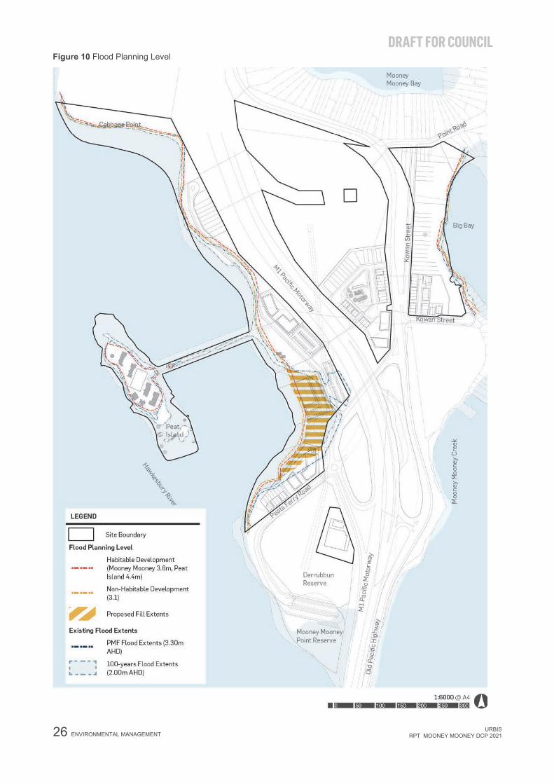
4.2.4. Flood Planning This section applies to land at or below the flood planning level and is to be read in conjunction with clause 7.2 Flood planning and clause 7.3 Floodplain risk management of the Central Coast LEP 2018.
Portions of the site are flood affected in the 100 year ARI storm event, including land that is located at the:
outskirts of Peat Island;
southern peninsula (carpark) of the mainland;
along the western coastline of the mainland; and
along the eastern coastline of the mainland, primarily at the proposed low density residential lots.
The 100 year ARI flood level expected at the site is approximately 2m AHD.
Given the topography of the site, the Probable Maximum Flood (PMF) flood extents are similar to those of the 100 year ARI storm event, and PMF flood level expected at the site is approximately 3.3m AHD.
4.2.4.1. Flood Planning Level (FPL)
Flood affected land is required to comply with the relevant FPL controls as outlined in Table 5 Flood Planning Level for Habitable and Non-Habitable Buildings at Mooney and Peat Island and as shown on Figure 10.
Table 5 Flood Planning Level for Habitable and Non-Habitable Buildings at Mooney and Peat Island
Location and Building Type Flood Planning Level (m AHD)
Mooney Buildings
Habitable Buildings 3.60 (100-YR ARI Flood Level, High SLR & Freeboard)
Non-Habitable Buildings 3.10 (100-YR ARI Flood Level & High SLR)
Peat Island Buildings
All Buildings 4.40 (PMF Flood Level & High SLR) NOTES:
An increase FPL is recommended for non-habitable and non-critical developments on Mooney as it minimises the risk of flood damage to proposed structures along the foreshore.
Peat Island is categorised as a high flood island where early evacuation is recommended, and safe refuge are to be provided on the island.
4.2.4.2. Flood Evacuation Plan
An Emergency Management Plan, including a detailed Evacuation Plan generally consistent with the indicative Flood Evacuation Plan shown in Figure 11 must be prepared by a suitably qualified professional and submitted to support any relevant DA for flood affected land.
The Emergency Management Plan must include provisions for safe refuge during the PMF event.
The Evacuation Plan must be prepared in consultation with NSW State Emergency Service, to ensure required supplies, such as food, power and emergency equipment, is available to the island
DRAFT FOR COUNCIL
26 ENVIRONMENTAL MANAGEMENT URBIS RPT_MOONEY MOONEY DCP 2021
Figure 10 Flood Planning Level

DRAFT FOR COUNCIL
URBIS RPT_MOONEY MOONEY DCP 2021 ENVIRONMENTAL MANAGEMENT 27
Figure 11 Indicative Flood Emergency Plan

DRAFT FOR COUNCIL
28 ENVIRONMENTAL MANAGEMENT URBIS RPT_MOONEY MOONEY DCP 2021
4.2.5. Stormwater Quality Management This section must be read in conjunction with Central Coast Council Civil Works Specifications, which provides minimum requirements for the design and construction of civil works including pavements, paths, earthworks, drainage and sewerage systems.
The site comprises steep topography in proximity to the Hawkesbury River and Mooney Creek. Any stormwater outlet is to be designed and constructed as per NRAR’s Guidelines for outlet structures on waterfront land to reduce erosion around the outlet point.
In addition, discharge from waterfront land is to be managed through quantity and quality management controls in accordance with Council’s stormwater discharge requirements.
A Water Quality Strategy is required to be prepared to accompany all developments and must be prepared by a suitably qualified profession to ensure that all developable land can meet water quality targets set out in Table 6.
Table 6 Water Quality Targets
Pollutant Reduction Target
Total Suspended Solids 80%
Total Phosphorus 45%
Total Nitrogen 45%
Total Gross Pollutants 80%
To achieve the pollutant reduction target identified above, developments must incorporate the following water quality strategies as per the locations shown in Figure 12.
Communal Treatment – are catchments which meet the water quality objectives by discharging stormwater runoff to a communal water quality facility. The communal water quality facilities may be shared by multiple developments within the site. Maintenance of the water quality facilities is to be consulted with Council and is to be confirmed prior to the lodgement of the relevant DA.
On-Site Treatment – are catchments which meet the water quality objectives by providing on-site treatment of stormwater runoff prior to discharging to the Hawkesbury River. Typically, these catchments are constrained topographically and cannot practically drain towards a communal facility location, therefore individual on-site treatment will be required. Water quality treatment measures are to be provided on a lot-by-lot basis and landowners will be expected to maintain their own water quality devices. A condition of consent will be applied to these lots to enforce onsite treatment for stormwater runoff to ensure water quality objectives are met.
Areas within the site which will remain undisturbed (or identified as national park/public recreation land) do not require water quality treatment.

DRAFT FOR COUNCIL
URBIS RPT_MOONEY MOONEY DCP 2021 ENVIRONMENTAL MANAGEMENT 29
Figure 12 Water Quality Strategy

DRAFT FOR COUNCIL
30 PUBLIC OPEN SPACE URBIS RPT_MOONEY MOONEY DCP 2021
5. PUBLIC OPEN SPACE There are four key public open spaces to be delivered within the site, as identified in Figure 13:
Foreshore Park: A connected foreshore parkland located adjacent to the foreshore opposite Peat Island. This public open space activates the waterfront and provides opportunities to access a range of informal recreational activities such as picnic areas, BBQ pods and potential adventure play area for kids.
Cabbage Point Park: A local park that connects Northern Foreshore Precinct and the Waterside Village. The provision of a passive open space at this location creates a visual break between the detached residential housing area and the potential apartment developments at Waterside Village (fronting Peat Island).
Mooney Mooney Park: A new local park in the eastern precinct that provides additional public open space for the public, the existing residential community at Mooney Mooney and future residents of Mooney Mooney Village.
Chapel Precinct Local Park: A local park integrated with the adaptive reuse of the Chapel as a new community focal point. The local park within the Chapel Residential Precinct will support the recreational needs of the new residential community and the general public, while providing linkages to the foreshore parkland through an east to west connector via the existing pedestrian underpass across M1 Pacific Motorway.
5.1. OBJECTIVES New Public Open Space in the Mooney Mooney and Peat Island site is to be designed to:
Support recreational and amenity needs of the communities through the provision of open lawn areas, shelters, picnic pods and active play areas.
Encourage walkable communities and deliver connected public foreshore access around Peat Island and along the river foreshore.
Connect with the existing reserve and environmental conservation area, including Derrubbun Reserves and Mooney Mooney Point at the south; Cabbage Point and Tank Hill at the north; and the protected riparian vegetation communities including mangroves along the eastern and western edge.
Provide new public amenities within the foreshore park or local parks that are designed to be in keeping with and respond to the local context and scenic setting.
Provide pedestrian pathways whose location, alignment and design prevent removal of wetlands, mangroves and native vegetation in the foreshore area.
5.2. CONTROLS There are three main types of public open spaces as identified in Figure 13. A Plan of Management is required to be prepared for the various types of open space at the relevant DA stage. The Plan of Management must contain policies for managing and maintaining the conservation area / parks, as well as a detailed conceptual plan for proposed development within the parks.

DRAFT FOR COUNCIL
URBIS RPT_MOONEY MOONEY DCP 2021 PUBLIC OPEN SPACE 31
Figure 13 Public Open Space

DRAFT FOR COUNCIL
32 ACCESS AND PARKING URBIS RPT_MOONEY MOONEY DCP 2021
6. ACCESS AND PARKING 6.1. STREET NETWORK, ACCESS AND PARKING The site comprise the following road network as illustrated in Figure 14:
Peats Ferry Road: Peat Ferry Road is an existing local road that requires upgrades to service new residential development at Southern Foreshore Precinct, while servicing existing boat ramp and car park at Mooney Mooney Point Reserve. It contains one lane in each direction with no kerbside parking.
Kowan Street: Kowan Street is an existing local road that connects Point Road to Old Pacific Highway. This local road requires upgrades and extension to service new residential development at Mooney Mooney Village and Chapel Residential Precinct.
New Neighbourhood Streets: New neighbourhood streets are to be provided in the Chapel Residential Precinct and the southern end of Mooney Mooney Village. The neighbourhood streets are designed to provide one lane in each direction for vehicular access and separated pathways for pedestrian and cycling.
New Laneways: New laneways are to be provided in the Chapel Residential Precinct and the new residential development area at the southern end of Mooney Mooney Village. The laneways are designed to provide vehicle access to individual lots.
Restricted Vehicle Access to Peat Island: Access to Peat Island is prioritised for pedestrian and cyclist. Vehicular access to Peat Island is to be restricted to emergency service vehicles and authorised vehicles only, including shuttle buses to and from the island to service tourism uses.
6.1.1. Objectives New and existing streets and parking areas in the Mooney Mooney and Peat Island site are to be designed to:
Provide a network of primary road, local street and laneways, responding to the exiting street hierarchy and layout of local streets.
Reduce the impact of vehicular access on the public domain.
Minimise the visual impact of on-site parking
6.1.2. Controls The design of new neighbourhood streets and road upgrades including laneways, share way, access
road, local road, medians and refuge islands are to be designed in accordance with the Australian Standards and Table 6.1 Road Hierarchy and Road Width Schedule (40 Year Pavement Design Life) of the Central Coast Council Civil Work Specification - Design Guideline 2018.
A comprehensive traffic and transport study prepared by a suitably qualified professional must be in accordance with the RMS Guide to Traffic Generating Developments to support relevant DAs. The study is to investigate the total impacts of the development on the surrounding road network.
Car parking at Mooney Mooney and Peat Island must comply with the following:
‒ On-site vehicle parking is to be provided in accordance with Chapter 2.13 transport and parking of the Central Coast DCP.
‒ Parking to support recreational uses is to be provided without compromising the scenic quality and amenity of Mooney Mooney and Peat Island; and
‒ Vehicle parking for tourist accommodation at Peat Island is to be provided within the Waterfront Village Precinct.

DRAFT FOR COUNCIL
URBIS RPT_MOONEY MOONEY DCP 2021 ACCESS AND PARKING 33
Figure 14 Road Hierarchy and Vehicle Movement Plan

DRAFT FOR COUNCIL
34 ACCESS AND PARKING URBIS RPT_MOONEY MOONEY DCP 2021
6.2. PEDESTRIAN AND CYCLE NETWORK 6.2.1. Objectives Create a pedestrian and cycle network across the Mooney Mooney and Peat Island site to:
Provide public access to the foreshore area.
Provide cycling and pedestrian connection throughout the site.
Provide safe and easy access to buildings to enable better use and enjoyment by people regardless of age and physical condition, whilst also contributing to the vitality and vibrancy of the public domain.
6.2.2. Controls Pedestrian and cycle network is required to be designed in accordance with Figure 15. In addition, the following controls applies:
A dedicated cycle lane must be provided along the Old Pacific Highway to connect with the existing cycle lane. Where possible, the cycle lane is to be extended to connect Mooney Mooney area with Hawkesbury River Station in Brooklyn.
The existing pedestrian underpass crossing near M1 Pacific Motorway must be maintained. Future improvements to the pedestrian underpass need be to be assessed against CPTED principles, including lighting requirement to provide a safer pedestrian connection.

DRAFT FOR COUNCIL
URBIS RPT_MOONEY MOONEY DCP 2021 ACCESS AND PARKING 35
Figure 15 Pedestrian and Cycle Movement Plan

DRAFT FOR COUNCIL
36 BUILT FORM GUIDANCE FOR NEW BUILDINGS IN HERITAGE PRECINCTS URBIS RPT_MOONEY MOONEY DCP 2021
7. BUILT FORM GUIDANCE FOR NEW BUILDINGS IN HERITAGE PRECINCTS
7.1. OBJECTIVES Future development is to protect and conserve the cultural heritage values and identified significance of
the place.
New buildings on Peat Island and Mooney Mooney are to support the future use and conservation of the identified elements of high heritage significance.
New buildings are to provide an appropriate physical buffer to minimise impact to elements of high heritage significance.
7.2. CONTROLS Peat Island
A single new building is permitted within the Peat Island Precinct, which is to be designed in accordance with
Figure 16 and must comply with the following:
Any new building is required to be designed in collaboration with a qualified heritage consultant to ensure that the significance of the place is protected. A Heritage Impact Statement must be prepared by a suitably qualified professional to accompany a Development Application for the proposal.
New buildings or structures, if required, are to be located within the areas of the Island which are already developed to maintain the existing setting of the place and separation between built form areas and open landscaped areas. New buildings and structures are not permissible within the large open space areas to the eastern end of the Island.
New buildings and structures are to be of a scale which is sympathetic and recessive to the existing buildings of Exceptional and High heritage significance on the Island. New buildings cannot visually dominate the visual setting of the Island and are to complement the bulk and scale of elements of High heritage significance.
New buildings cannot be constructed abutting existing elements of Exceptional, High or Moderate significance. Appropriate setbacks must be applied to allow the existing buildings and elements of heritage significance to have their own setting and visual curtilage. A minimum setback of at least 6 metres must be applied to all elements of Exceptional or High heritage significance.
New buildings and structures cannot seek to replicate traditional design and detailing. Rather, contemporary design is encouraged which is sympathetic to the setting of the place and does not detract from the ability to understand and interpret the history of the place.
Based on the above principles, a single location for a potential new building has been identified in the centre of the existing built form on the Island. This new building is required to support a robust adaptive reuse of the place and to contain modern facilities and services to support a new use. This is a proposed footprint location and the future building will be subject to detailed design and heritage assessment.

DRAFT FOR COUNCIL
URBIS RPT_MOONEY MOONEY DCP 2021
BUILT FORM GUIDANCE FOR NEW BUILDINGS IN HERITAGE PRECINCTS 37
Figure 16 Peat Island Precinct Plan

DRAFT FOR COUNCIL
38 BUILT FORM GUIDANCE FOR NEW BUILDINGS IN HERITAGE PRECINCTS URBIS RPT_MOONEY MOONEY DCP 2021
Chapel Precinct
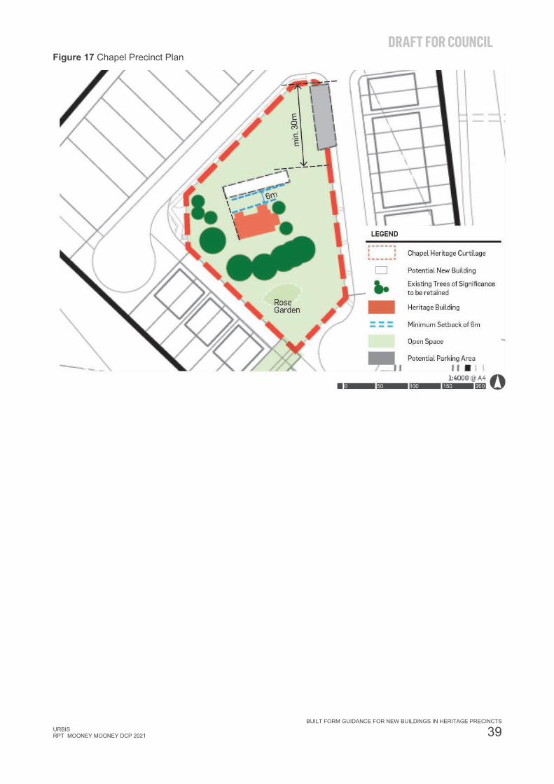
New buildings within the Chapel Precinct are to be designed in accordance with Figure 17 and must comply with the following:
The use of the new building is to accommodate community facilities.
The new building is to be designed in accordance with the following built form controls:
‒ Remove and replace Lavatory Block with a new building on the northern side of the Chapel.
‒ Orientated parallel with the Chapel building, the long side of the new building running east-west with a minimum 6m separation from the retained Chapel building. The most western extent of the new building is to be generally in line with the most western extent of the Chapel building.
‒ Minimum setback of approximately 30m from the north-eastern corner of the site.
‒ Approximate total GFA of 300sqm including existing Chapel and the new building.
‒ Maximum height of 1 storey with the massing, bulk and scale of the new building to be in keeping with the existing massing, bulk and scale of retained heritage elements. Building is to be built into the landscape on the northern side with an at-grade indoor-outdoor room connecting to the Chapel building on the southern side.
Parking, if required, is to be located in accordance with parking provision requirements in Chapter 2.13 of the Central Coast DCP and be provided as street parking along the eastern boundary. Design of the parking areas is to incorporate landscape elements, planting, pervious surfaces etc to minimise visual impact.
No development, including buildings or parking areas, is to be located south of the retained trees on the southern side of the Chapel building or in the vicinity of the rose garden. This area is to be retained and enhanced as a landscape element.
DRAFT FOR COUNCIL
URBIS RPT_MOONEY MOONEY DCP 2021
BUILT FORM GUIDANCE FOR NEW BUILDINGS IN HERITAGE PRECINCTS 39
Figure 17 Chapel Precinct Plan
DRAFT FOR COUNCIL
40 BUILT FORM GUIDELINES FOR RESIDENTIAL DEVELOPMENTS URBIS RPT_MOONEY MOONEY DCP 2021
8. BUILT FORM GUIDELINES FOR RESIDENTIAL DEVELOPMENTS
This section is to be read in conjunction with other relevant chapters of Central Coast DCP 2018, including but not limited to:
Chapter 2.1 Dwelling houses, secondary dwellings and ancillary development
Chapter 2.2 Dual occupancy and multi dwelling housing
Chapter 2.3 Residential Flat Buildings and shop top housing
Chapter 2.4 Subdivision
Residential developments must also be designed in accordance with State Environmental Planning Policy (SEPP) 65 – Design Quality of Residential Apartment Development, the Apartment Design Guide (ADG) (Department of Planning and Environment 2015) and the Low Rise Housing Diversity Guide where applicable.
8.1. OBJECTIVES Encourage development that is compatible with the desired future character of the precinct.
Provide design standards that achieve a high level of amenity and aesthetic quality.
Promote sustainable development and protect areas with conservation value.
Encourage the provision of a variety of dwelling types and allow for innovation in individual design.
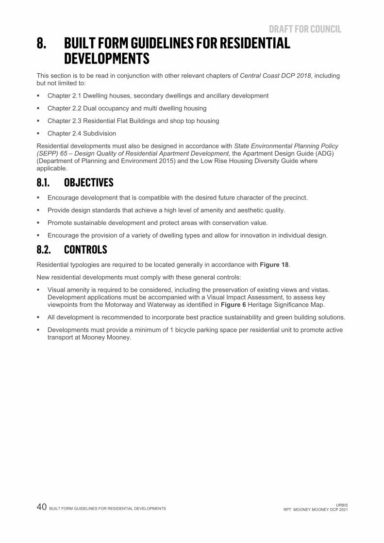
8.2. CONTROLS Residential typologies are required to be located generally in accordance with Figure 18.
New residential developments must comply with these general controls:
Visual amenity is required to be considered, including the preservation of existing views and vistas. Development applications must be accompanied with a Visual Impact Assessment, to assess key viewpoints from the Motorway and Waterway as identified in Figure 6 Heritage Significance Map.
All development is recommended to incorporate best practice sustainability and green building solutions.
Developments must provide a minimum of 1 bicycle parking space per residential unit to promote active transport at Mooney Mooney.

DRAFT FOR COUNCIL
URBIS RPT_MOONEY MOONEY DCP 2021 BUILT FORM GUIDELINES FOR RESIDENTIAL DEVELOPMENTS 41
Figure 18 Overall Subdivision Layout Plan

DRAFT FOR COUNCIL
42 BUILT FORM GUIDELINES FOR RESIDENTIAL DEVELOPMENTS URBIS RPT_MOONEY MOONEY DCP 2021
8.2.1. Front and Rear Setback Controls by Precincts Developments must comply with the minimum setback controls outlined in Table 7.
Table 7 Minimum Setback Controls
Form of Residential Development Minimum Setback controls Chapel Residential Precinct (refer to Figure 19) Detached Dwelling, secondary dwellings and ancillary development
As per Chapter 2.1 of Central Coast DCP 2018
Dual Occupancies and Multi Dwelling Housing
Front: minimum 2m fronting private driveway (laneway); minimum 3.5m fronting neighbourhood street or local street. Rear: 3m to building line; 8.5m with rear facing local street. Side: 1.5m
Residential Flat Buildings and Shop Top Housing
Side: 3m from primary road and neighbourhood street
Additional requirements Developments directly adjacent to the M1 Motorway are required to undertake geotechnical investigation to determine the zone of influence and mitigation measures to manage the level difference between the M1 and the developable land. Development application within this precinct and along the M1 Motorway must be referred to Transport for NSW.
Waterside Village (refer to Figure 20) Residential Flat Buildings and Shop Top Housing
Front: 3m Rear: Determined by the building line (APZ) Side: 3m
Additional requirements Developments directly adjacent to the M1 Motorway are required to undertake geotechnical investigation to determine the zone of influence and mitigation measures to manage the level difference between the M1 and the developable land. Development application within this precinct and along the M1 Motorway must be referred to Transport for NSW.
Mooney Mooney Village (refer to Figure 21)
Detached Dwelling, secondary dwellings and ancillary development
As per Chapter 2.1 of Central Coast DCP 2018
Dual Occupancies and Multi Dwelling Housing
Front: Minimum 2m fronting private driveway (laneway); minimum 3.5m fronting neighbourhood street or local street. Side: 1.5m
Northern Foreshore Precinct (refer to Figure 22) Detached Dwelling, secondary dwellings and ancillary development
As per Chapter 2.1 of Central Coast DCP 2018
Southern Foreshore Precinct (refer to Figure 23) Dual Occupancies and Multi Dwelling Housing
Front: Minimum 3.5m fronting local street. Rear: Determined by the Outer Vegetated Riparian Zone Side: 1.5m
Residential Flat Buildings Front: 6m fronting local street. Side: Minimum 6m

DRAFT FOR COUNCIL
URBIS RPT_MOONEY MOONEY DCP 2021 BUILT FORM GUIDELINES FOR RESIDENTIAL DEVELOPMENTS 43
Figure 21 Mooney Mooney Village Plan

DRAFT FOR COUNCIL
44 BUILT FORM GUIDELINES FOR RESIDENTIAL DEVELOPMENTS URBIS RPT_MOONEY MOONEY DCP 2021
Figure 19 Chapel Residential Precinct Plan

DRAFT FOR COUNCIL
URBIS RPT_MOONEY MOONEY DCP 2021 BUILT FORM GUIDELINES FOR RESIDENTIAL DEVELOPMENTS 45
Figure 20 Waterside Village Plan

DRAFT FOR COUNCIL
46 BUILT FORM GUIDELINES FOR RESIDENTIAL DEVELOPMENTS URBIS RPT_MOONEY MOONEY DCP 2021
Figure 21 Mooney Mooney Village Plan

DRAFT FOR COUNCIL
URBIS RPT_MOONEY MOONEY DCP 2021 BUILT FORM GUIDELINES FOR RESIDENTIAL DEVELOPMENTS 47
Figure 22 Northern Foreshore Precinct Plan

DRAFT FOR COUNCIL
48 BUILT FORM GUIDELINES FOR RESIDENTIAL DEVELOPMENTS URBIS RPT_MOONEY MOONEY DCP 2021
Figure 23 Southern Foreshore Precinct Plan

DRAFT FOR COUNCIL
URBIS RPT_MOONEY MOONEY DCP 2021 BUILT FORM GUIDELINES FOR RESIDENTIAL DEVELOPMENTS 49
8.2.2. Acoustic Treatments for Residential Developments located along Pacific Highway
Acoustic facade treatments as per Part C: Development impacted by rail corridors and busy roads of the Development Near Rail Corridors and Busy Roads – Interim Guideline must be applied for the noise affected areas as shown on Figure 22.

DRAFT FOR COUNCIL
50 BUILT FORM GUIDELINES FOR RESIDENTIAL DEVELOPMENTS URBIS RPT_MOONEY MOONEY DCP 2021
Figure 24 Acoustic Treatment

URBIS RPT_MOONEY MOONEY DCP 2021 APPENDICES
DISCLAIMER This report is dated 16 October 2019 and incorporates information and events up to that date only and excludes any information arising, or event occurring, after that date which may affect the validity of Urbis Pty Ltd’s (Urbis) opinion in this report. Urbis prepared this report on the instructions, and for the benefit only, of Property NSW (Instructing Party) for the purpose of Location Specific DCP (Purpose) and not for any other purpose or use. To the extent permitted by applicable law, Urbis expressly disclaims all liability, whether direct or indirect, to the Instructing Party which relies or purports to rely on this report for any purpose other than the Purpose, and to any other person which relies or purports to rely on this report for any purpose whatsoever (including the Purpose).
In preparing this report, Urbis was required to make judgements which may be affected by unforeseen future events, the likelihood and effects of which are not capable of precise assessment.
All surveys, forecasts, projections and recommendations contained in or associated with this report are made in good faith and on the basis of information supplied to Urbis at the date of this report, and upon which Urbis relied. Achievement of the projections and budgets set out in this report will depend, among other things, on the actions of others over which Urbis has no control.
In preparing this report, Urbis may rely on or refer to documents in a language other than English, which Urbis may arrange to be translated. Urbis is not responsible for the accuracy or completeness of such translations and disclaims any liability for any statement or opinion made in this report being inaccurate or incomplete arising from such translations.
Whilst Urbis has made all reasonable inquiries it believes necessary in preparing this report, it is not responsible for determining the completeness or accuracy of information provided to it. Urbis (including its officers and personnel) is not liable for any errors or omissions, including in information provided by the Instructing Party or another person or upon which Urbis relies, provided that such errors or omissions are not made by Urbis recklessly or in bad faith.
This report has been prepared with due care and diligence by Urbis and the statements and opinions given by Urbis in this report are given in good faith and in the reasonable belief that they are correct and not misleading, subject to the limitations above.