Embed Size (px)
Citation preview

LocalView Fusion Platform
Release Notes
8th June 2015
Platform Build 4.3.106.0

LocalView Fusion Platform Release Notes
Confidentiality Statement
This document contains information which is confidential to ESRI (UK) Limited. No
part of this document should be reproduced or revealed to third parties without the
express permission of ESRI (UK) Limited.
© 2015 ESRI (UK) Ltd and its third party licensors. All rights reserved.
ESRI (UK) Ltd
Millennium House
65 Walton Street
Aylesbury
Buckinghamshire
HP21 7QG
Tel: +44 (0) 1296 745500
Fax: +44 (0) 1296 745544
Website: www.esriuk.com
Release Date: 16th June 2015
LocalView Fusion Platform Release Notes
ESRI (UK) 2015 1
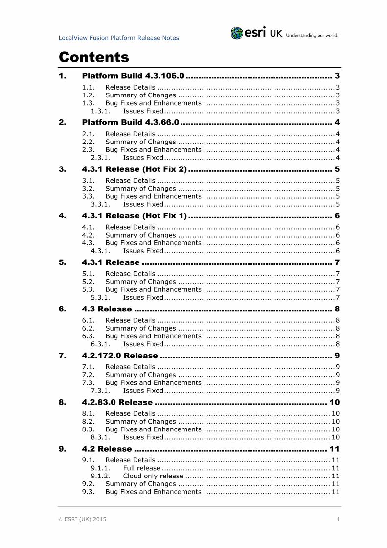
Contents
1. Platform Build 4.3.106.0 ......................................................... 3
1.1. Release Details ............................................................................ 3 1.2. Summary of Changes ................................................................... 3 1.3. Bug Fixes and Enhancements ........................................................ 3
1.3.1. Issues Fixed ......................................................................... 3
2. Platform Build 4.3.66.0 ........................................................... 4
2.1. Release Details ............................................................................ 4 2.2. Summary of Changes ................................................................... 4 2.3. Bug Fixes and Enhancements ........................................................ 4
2.3.1. Issues Fixed ......................................................................... 4
3. 4.3.1 Release (Hot Fix 2) ........................................................ 5
3.1. Release Details ............................................................................ 5 3.2. Summary of Changes ................................................................... 5 3.3. Bug Fixes and Enhancements ........................................................ 5
3.3.1. Issues Fixed ......................................................................... 5
4. 4.3.1 Release (Hot Fix 1) ........................................................ 6
4.1. Release Details ............................................................................ 6 4.2. Summary of Changes ................................................................... 6 4.3. Bug Fixes and Enhancements ........................................................ 6
4.3.1. Issues Fixed ......................................................................... 6
5. 4.3.1 Release .......................................................................... 7
5.1. Release Details ............................................................................ 7 5.2. Summary of Changes ................................................................... 7 5.3. Bug Fixes and Enhancements ........................................................ 7
5.3.1. Issues Fixed ......................................................................... 7
6. 4.3 Release ............................................................................. 8
6.1. Release Details ............................................................................ 8 6.2. Summary of Changes ................................................................... 8 6.3. Bug Fixes and Enhancements ........................................................ 8
6.3.1. Issues Fixed ......................................................................... 8
7. 4.2.172.0 Release ................................................................... 9
7.1. Release Details ............................................................................ 9 7.2. Summary of Changes ................................................................... 9 7.3. Bug Fixes and Enhancements ........................................................ 9
7.3.1. Issues Fixed ......................................................................... 9
8. 4.2.83.0 Release ................................................................... 10
8.1. Release Details .......................................................................... 10 8.2. Summary of Changes ................................................................. 10 8.3. Bug Fixes and Enhancements ...................................................... 10
8.3.1. Issues Fixed ....................................................................... 10
9. 4.2 Release ........................................................................... 11
9.1. Release Details .......................................................................... 11 9.1.1. Full release ........................................................................ 11 9.1.2. Cloud only release .............................................................. 11
9.2. Summary of Changes ................................................................. 11 9.3. Bug Fixes and Enhancements ...................................................... 11
LocalView Fusion Platform Release Notes
ESRI (UK) 2015 2
9.3.1. Enhancements ................................................................... 11 9.3.2. Issues Fixed ....................................................................... 11
10. 4.1.115.0 (Cloud Only) .......................................................... 13
10.1. Release Details .......................................................................... 13 10.1.1. Issues Fixed ....................................................................... 13
11. 4.1 Release ........................................................................... 14
11.1. Release Details .......................................................................... 14 11.2. Summary of Changes ................................................................. 14 11.3. Bug Fixes and Enhancements ...................................................... 14
11.3.1. Enhancements ................................................................... 14 11.3.2. Issues Fixed ....................................................................... 14
12. Known Issues ....................................................................... 16
12.1. Known Issues and Workarounds ................................................... 16
13. Help and Contact Information .............................................. 20
13.1. Documentation .......................................................................... 20 13.2. Contact ..................................................................................... 20
LocalView Fusion Platform Release Notes
ESRI (UK) 2015 3
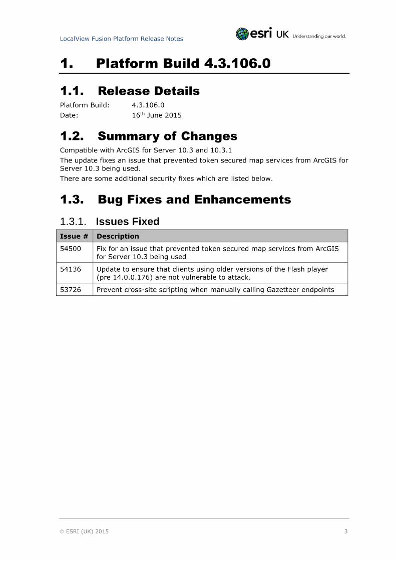
1. Platform Build 4.3.106.0
1.1. Release Details
Platform Build: 4.3.106.0
Date: 16th June 2015
1.2. Summary of Changes
Compatible with ArcGIS for Server 10.3 and 10.3.1
The update fixes an issue that prevented token secured map services from ArcGIS for
Server 10.3 being used.
There are some additional security fixes which are listed below.
1.3. Bug Fixes and Enhancements
1.3.1. Issues Fixed
Issue # Description
54500 Fix for an issue that prevented token secured map services from ArcGIS
for Server 10.3 being used
54136 Update to ensure that clients using older versions of the Flash player
(pre 14.0.0.176) are not vulnerable to attack.
53726 Prevent cross-site scripting when manually calling Gazetteer endpoints
LocalView Fusion Platform Release Notes
ESRI (UK) 2015 4
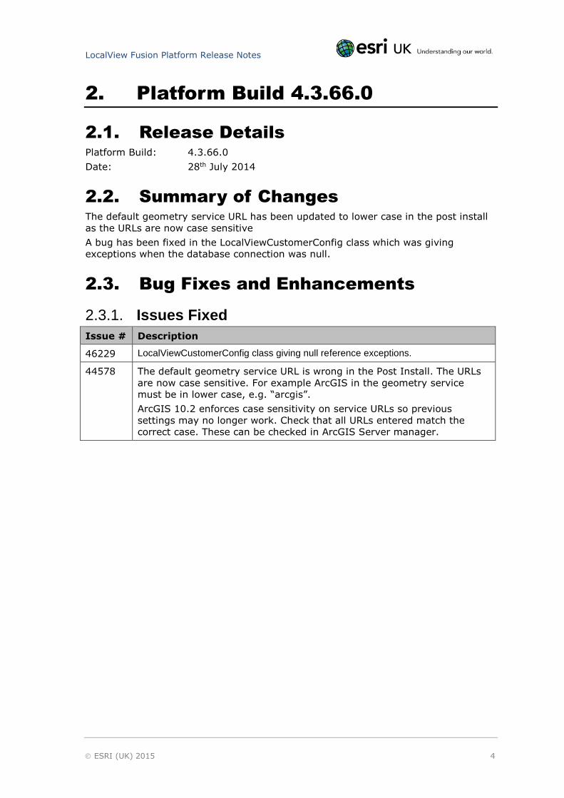
2. Platform Build 4.3.66.0
2.1. Release Details
Platform Build: 4.3.66.0
Date: 28th July 2014
2.2. Summary of Changes
The default geometry service URL has been updated to lower case in the post install
as the URLs are now case sensitive
A bug has been fixed in the LocalViewCustomerConfig class which was giving
exceptions when the database connection was null.
2.3. Bug Fixes and Enhancements
2.3.1. Issues Fixed
Issue # Description
46229 LocalViewCustomerConfig class giving null reference exceptions.
44578 The default geometry service URL is wrong in the Post Install. The URLs
are now case sensitive. For example ArcGIS in the geometry service
must be in lower case, e.g. “arcgis”.
ArcGIS 10.2 enforces case sensitivity on service URLs so previous
settings may no longer work. Check that all URLs entered match the
correct case. These can be checked in ArcGIS Server manager.
LocalView Fusion Platform Release Notes
ESRI (UK) 2015 5
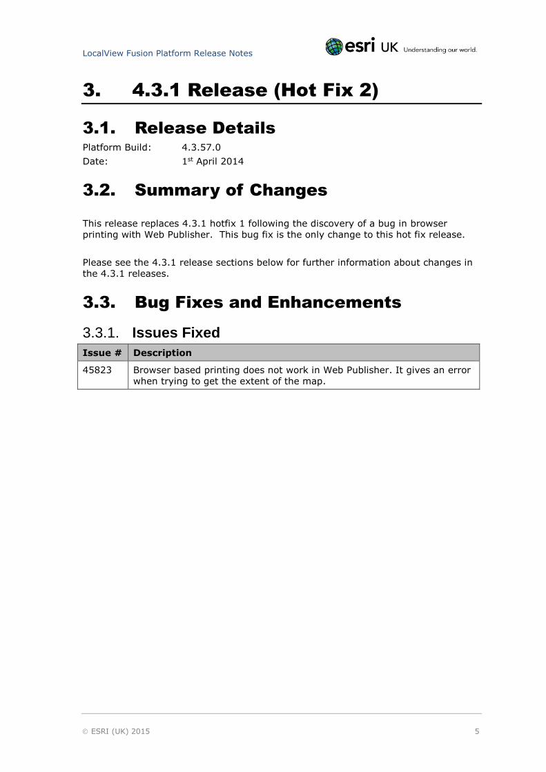
3. 4.3.1 Release (Hot Fix 2)
3.1. Release Details
Platform Build: 4.3.57.0
Date: 1st April 2014
3.2. Summary of Changes
This release replaces 4.3.1 hotfix 1 following the discovery of a bug in browser
printing with Web Publisher. This bug fix is the only change to this hot fix release.
Please see the 4.3.1 release sections below for further information about changes in
the 4.3.1 releases.
3.3. Bug Fixes and Enhancements
3.3.1. Issues Fixed
Issue # Description
45823 Browser based printing does not work in Web Publisher. It gives an error
when trying to get the extent of the map.
LocalView Fusion Platform Release Notes
ESRI (UK) 2015 6
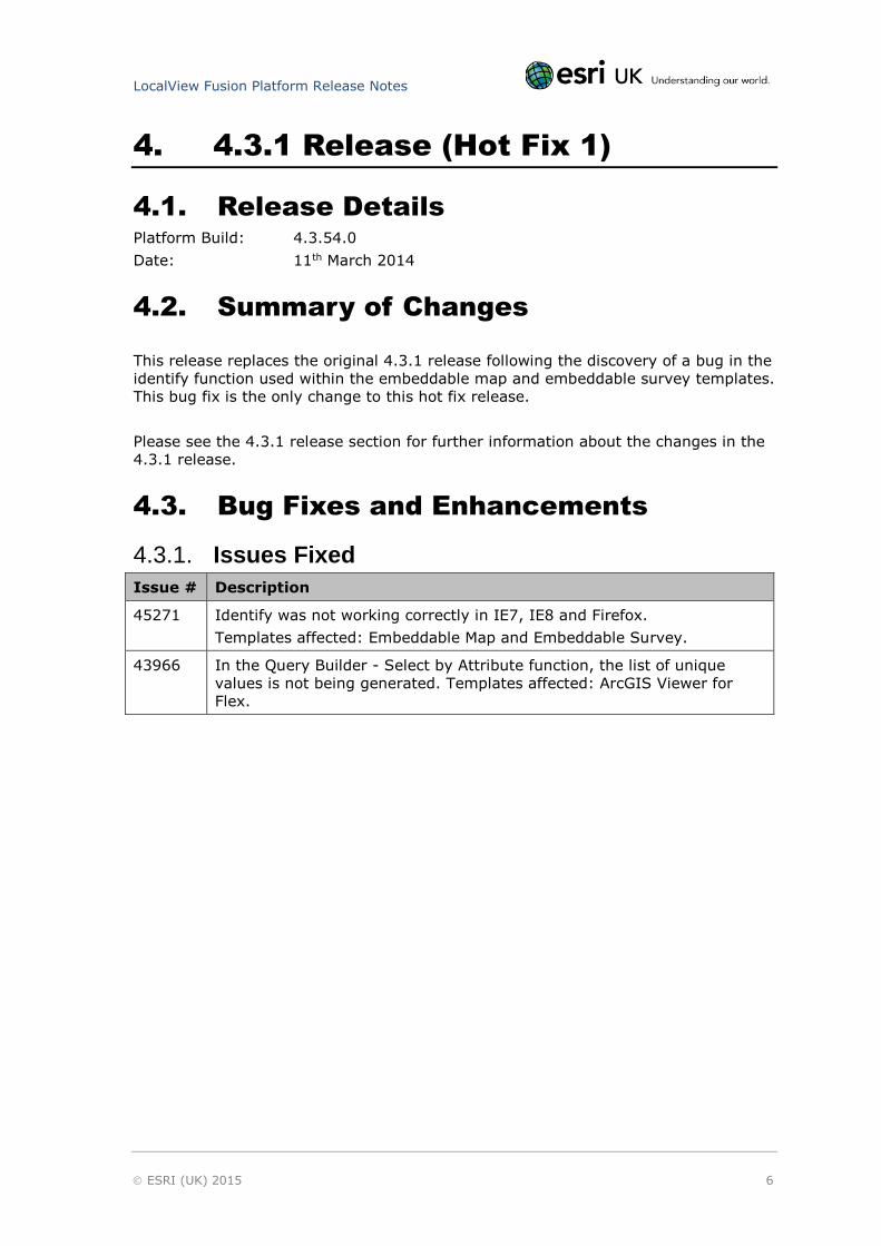
4. 4.3.1 Release (Hot Fix 1)
4.1. Release Details
Platform Build: 4.3.54.0
Date: 11th March 2014
4.2. Summary of Changes
This release replaces the original 4.3.1 release following the discovery of a bug in the
identify function used within the embeddable map and embeddable survey templates.
This bug fix is the only change to this hot fix release.
Please see the 4.3.1 release section for further information about the changes in the
4.3.1 release.
4.3. Bug Fixes and Enhancements
4.3.1. Issues Fixed
Issue # Description
45271 Identify was not working correctly in IE7, IE8 and Firefox.
Templates affected: Embeddable Map and Embeddable Survey.
43966 In the Query Builder - Select by Attribute function, the list of unique
values is not being generated. Templates affected: ArcGIS Viewer for
Flex.
LocalView Fusion Platform Release Notes
ESRI (UK) 2015 7
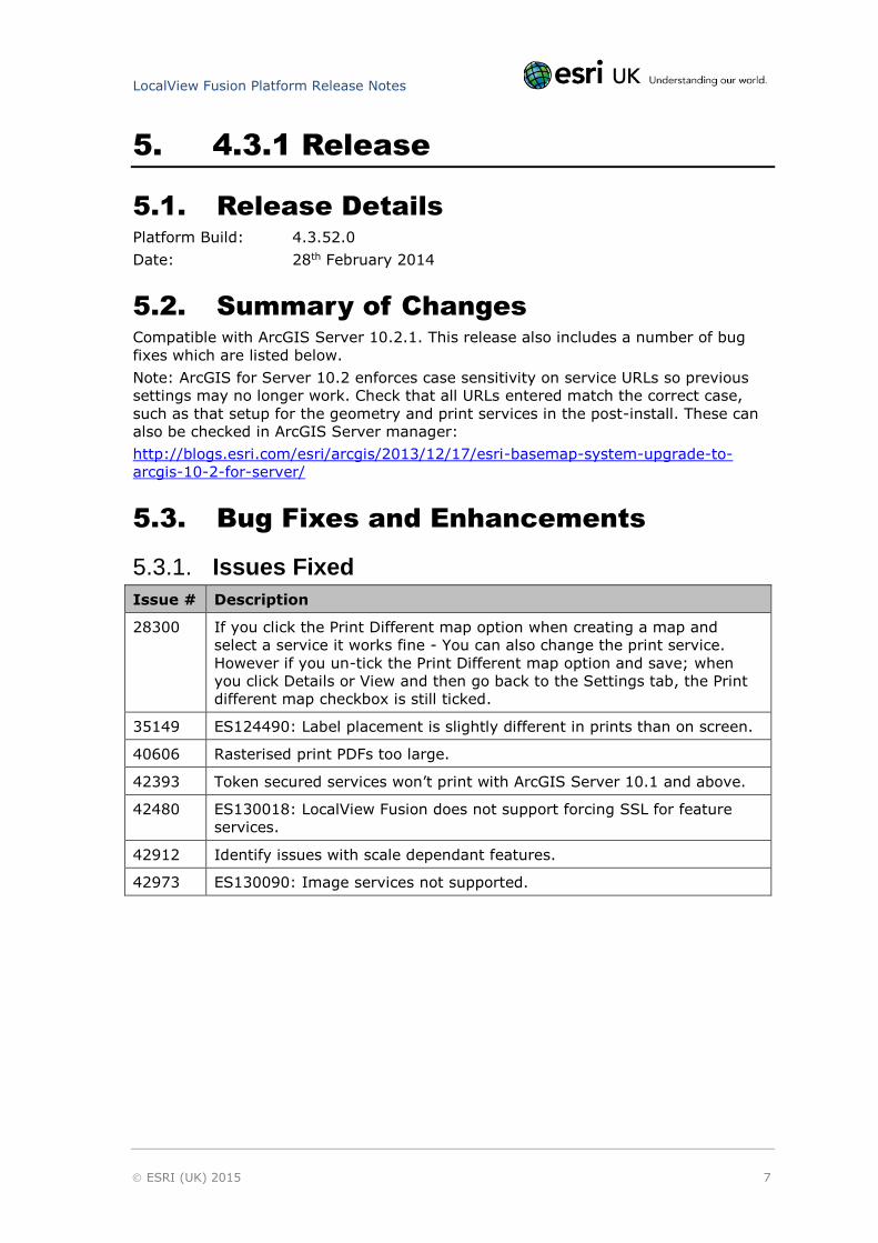
5. 4.3.1 Release
5.1. Release Details
Platform Build: 4.3.52.0
Date: 28th February 2014
5.2. Summary of Changes
Compatible with ArcGIS Server 10.2.1. This release also includes a number of bug
fixes which are listed below.
Note: ArcGIS for Server 10.2 enforces case sensitivity on service URLs so previous
settings may no longer work. Check that all URLs entered match the correct case,
such as that setup for the geometry and print services in the post-install. These can
also be checked in ArcGIS Server manager:
http://blogs.esri.com/esri/arcgis/2013/12/17/esri-basemap-system-upgrade-to-
arcgis-10-2-for-server/
5.3. Bug Fixes and Enhancements
5.3.1. Issues Fixed
Issue # Description
28300 If you click the Print Different map option when creating a map and
select a service it works fine - You can also change the print service.
However if you un-tick the Print Different map option and save; when
you click Details or View and then go back to the Settings tab, the Print
different map checkbox is still ticked.
35149 ES124490: Label placement is slightly different in prints than on screen.
40606 Rasterised print PDFs too large.
42393 Token secured services won’t print with ArcGIS Server 10.1 and above.
42480 ES130018: LocalView Fusion does not support forcing SSL for feature
services.
42912 Identify issues with scale dependant features.
42973 ES130090: Image services not supported.
LocalView Fusion Platform Release Notes
ESRI (UK) 2015 8
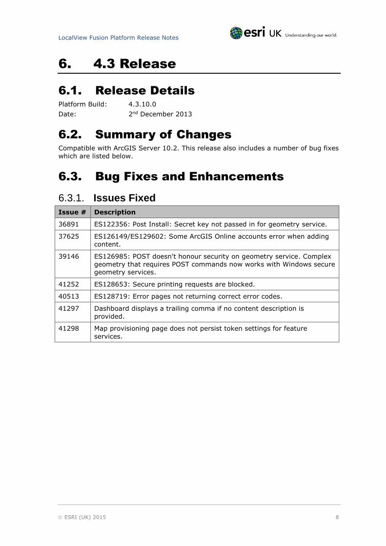
6. 4.3 Release
6.1. Release Details
Platform Build: 4.3.10.0
Date: 2nd December 2013
6.2. Summary of Changes
Compatible with ArcGIS Server 10.2. This release also includes a number of bug fixes
which are listed below.
6.3. Bug Fixes and Enhancements
6.3.1. Issues Fixed
Issue # Description
36891 ES122356: Post Install: Secret key not passed in for geometry service.
37625 ES126149/ES129602: Some ArcGIS Online accounts error when adding
content.
39146 ES126985: POST doesn't honour security on geometry service. Complex
geometry that requires POST commands now works with Windows secure
geometry services.
41252 ES128653: Secure printing requests are blocked.
40513 ES128719: Error pages not returning correct error codes.
41297 Dashboard displays a trailing comma if no content description is
provided.
41298 Map provisioning page does not persist token settings for feature
services.

LocalView Fusion Platform Release Notes
ESRI (UK) 2015 9
7. 4.2.172.0 Release
7.1. Release Details
Platform Build: 4.2.172.0
Date: 15th July 2013
7.2. Summary of Changes
An option has been added in provisioning not to return the geometry on feeds. This
allows feeds to run faster if you do not require the results displayed on the map.
Also URLS chosen when provisioning sites can now include underscores and hyphens.
7.3. Bug Fixes and Enhancements
7.3.1. Issues Fixed
Issue # Description
33263 Option not to return geometry on feeds. Feeds can now just be listed
without displaying the results on the map.
31664 Underscores and hyphens are now acceptable characters in application
URLs.
28415 Fixed - Get Capabilities button misaligned in IE7.
28318 Visual notification added to indicate when an application is paused.

LocalView Fusion Platform Release Notes
ESRI (UK) 2015 10
8. 4.2.83.0 Release
8.1. Release Details
Platform Build: 4.2.83.0
Date: 10th April 2013
8.2. Summary of Changes
We have fixed a bug in the 4.2 platform release, which was affecting printing under
certain circumstances. The problem stopped picture marker symbols from printing,
affecting the Web Publisher and Navigator templates.
The problem occurred if a graphic pin was displayed following a gazetteer search;
and only if the application was both public and being accessed by an anonymous
user, or by a user accessing the application using internal endpoints (Windows
Authentication – Active Directory).
8.3. Bug Fixes and Enhancements
8.3.1. Issues Fixed
Issue # Description
36494 Printing Issue: ES124820, ES125520, ES125600, and ES125638 -
Search icon URL not being converted to a local path.
Printing is failing on templates that use a picture marker symbol for the
marker pin on a gazetteer search (Web Publisher and Navigator).
The issue was found on active directory secured endpoints, and
applications set to public.

LocalView Fusion Platform Release Notes
ESRI (UK) 2015 11
9. 4.2 Release
9.1. Release Details
9.1.1. Full release Platform Build: 4.2.65.0
Date: 11th March 2013
Note: The full release included a few additional bug fixes which are marked with an *
in the table below
9.1.2. Cloud only release Platform Build: 4.2.19.0
Date: 18th February 2013
9.2. Summary of Changes
A number of quality improvements and enhancements.
New functionality including:
Enhanced ArcGIS Viewer for Flex template;
New Embeddable Survey template based upon the old survey template, but
with improved and additional functionality.
See the individual template release notes for details of new functionality in the
templates.
9.3. Bug Fixes and Enhancements
This release also includes issues fixed from previous cloud only releases.
9.3.1. Enhancements
Case # Description
34108 Directory name now defaults to Radar. Note that the directory install
path now always defaults to the “Radar” name and not to “LocalView”.
Radar is the name of the underlying platform which LocalView Fusion is
built upon.
34100 Only services owned by the linked ArcGIS Online user could be seen.
Added the ability for administrators to log into ArcGIS Online and view all
services that have been published by other users within the organisation.
34097 Permission settings – Added drop down list of users/groups.
33807 ES123811: Added caching of map service tiles.
32644 Product name is configurable to allow for both LocalView Fusion and
Radar brand name installs.
9.3.2. Issues Fixed
Issue # Description
LocalView Fusion Platform Release Notes
ESRI (UK) 2015 12
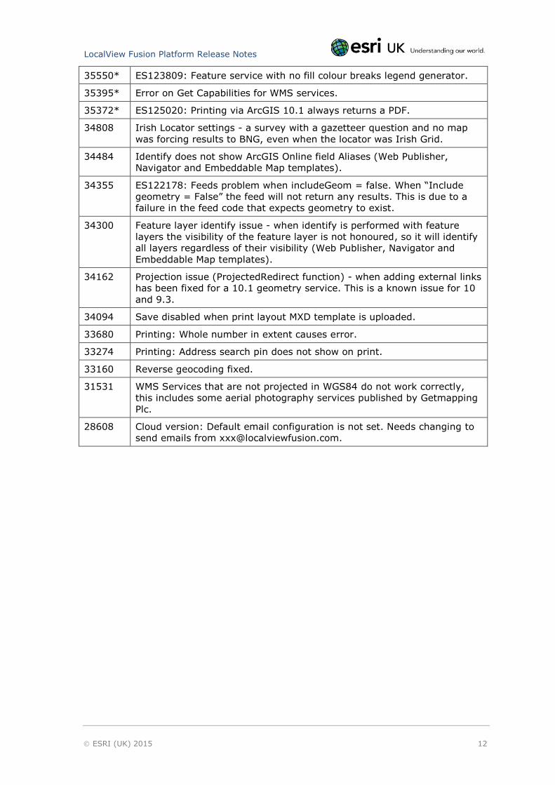
35550* ES123809: Feature service with no fill colour breaks legend generator.
35395* Error on Get Capabilities for WMS services.
35372* ES125020: Printing via ArcGIS 10.1 always returns a PDF.
34808 Irish Locator settings - a survey with a gazetteer question and no map
was forcing results to BNG, even when the locator was Irish Grid.
34484 Identify does not show ArcGIS Online field Aliases (Web Publisher,
Navigator and Embeddable Map templates).
34355 ES122178: Feeds problem when includeGeom = false. When “Include
geometry = False” the feed will not return any results. This is due to a
failure in the feed code that expects geometry to exist.
34300 Feature layer identify issue - when identify is performed with feature
layers the visibility of the feature layer is not honoured, so it will identify
all layers regardless of their visibility (Web Publisher, Navigator and
Embeddable Map templates).
34162 Projection issue (ProjectedRedirect function) - when adding external links
has been fixed for a 10.1 geometry service. This is a known issue for 10
and 9.3.
34094 Save disabled when print layout MXD template is uploaded.
33680 Printing: Whole number in extent causes error.
33274 Printing: Address search pin does not show on print.
33160 Reverse geocoding fixed.
31531 WMS Services that are not projected in WGS84 do not work correctly,
this includes some aerial photography services published by Getmapping
Plc.
28608 Cloud version: Default email configuration is not set. Needs changing to
send emails from [email protected].
LocalView Fusion Platform Release Notes
ESRI (UK) 2015 13
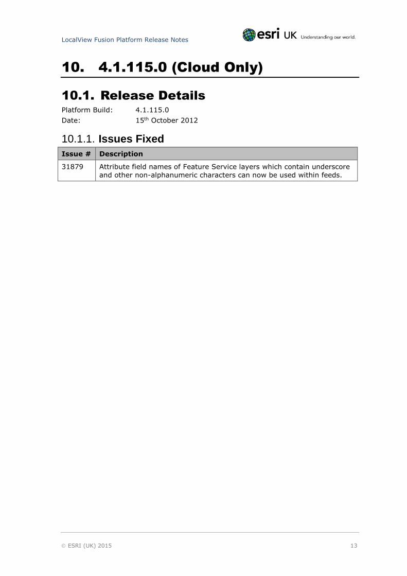
10. 4.1.115.0 (Cloud Only)
10.1. Release Details
Platform Build: 4.1.115.0
Date: 15th October 2012
10.1.1. Issues Fixed
Issue # Description
31879 Attribute field names of Feature Service layers which contain underscore
and other non-alphanumeric characters can now be used within feeds.

LocalView Fusion Platform Release Notes
ESRI (UK) 2015 14
11. 4.1 Release
11.1. Release Details
Platform Build: 4.1.110.0
Date: 3rd October 2012
11.2. Summary of Changes
New password policy and password validation have been added to the Administration
area. Define your own password policy and set validation. The new password policy
screen can be found under the administration menu.
New buttons to clear server caches are available in the Administration > Misc area.
11.3. Bug Fixes and Enhancements
11.3.1. Enhancements
Case # Description
26346 Support for SQL Server 2012.
30847 Change My Hosted Content to ArcGIS Online.
31425 Added ability to clear cached legend images.
31694 Application title character restriction increased to 80 characters.
11.3.2. Issues Fixed
Issue # Description
10394 Legend display incorrect for layers in the same map service with the
same name.
20150 Printing fails on maps with WKT definition.
28118 Context help incorrect for map display names.
28399 Deleted user login error.
29895 Sites can only be paused by administrators and not application
managers.
30208 Cannot edit properties after creating a link.
30490 Problems selecting services with long descriptions through the map
selector.
30747 Hide the system user in the User Administration page.
30795 Email address of external user accounts can no longer be edited.
31032 Identify tool does not honour scale thresholds. Attributes are now
returned for Visible layers only.
31216 Adding feeds to templates: “At Location” should not allow distance
parameter to be entered.
LocalView Fusion Platform Release Notes
ESRI (UK) 2015 15
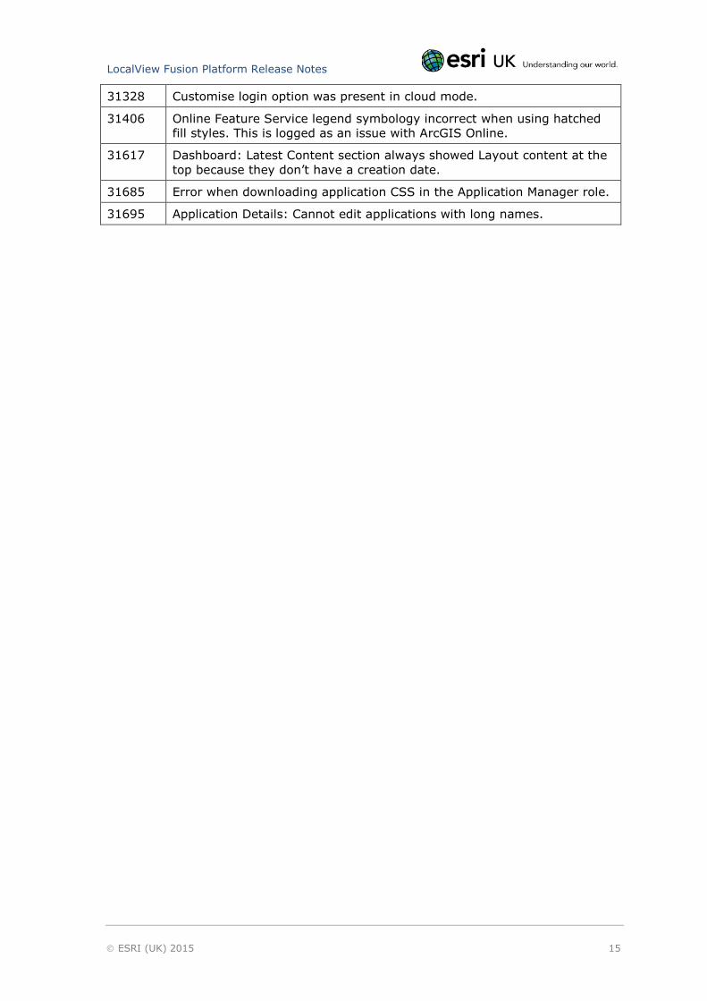
31328 Customise login option was present in cloud mode.
31406 Online Feature Service legend symbology incorrect when using hatched
fill styles. This is logged as an issue with ArcGIS Online.
31617 Dashboard: Latest Content section always showed Layout content at the
top because they don’t have a creation date.
31685 Error when downloading application CSS in the Application Manager role.
31695 Application Details: Cannot edit applications with long names.

LocalView Fusion Platform Release Notes
ESRI (UK) 2015 16
12. Known Issues
12.1. Known Issues and Workarounds
Issue # Description
48640 CAS-02551-C5D1L9: Printing WMS services does not work correctly.
Printing does not honour the configured WMS service, it just shows
everything.
47321 CAS-01306-T5N0S3: Post Install fails intermittently to upgrade custom
templates.
46090 Esri Locators appear in the list of ESRI UK online services as map
content not gazetteers.
42031 Feed distances are not working for polygons using ArcGIS Server 10.2
Find Nearest SOE. There is a missing library which requires ArcGIS
Desktop to be installed.
41577 The ArcGIS online “map settings” service name in the display is wrong
if you have multiple ArcGIS online accounts. The correct map data is
displayed correctly in the application just not in settings.
41407 Issue with map control - if you drag a new overlay map to a position
BETWEEN or ABOVE existing overlay maps, you get an error message
when you save. Drop maps on ‘Drop Maps Here’ first before moving
them to another position.
40705 ES128597: Permissions for an application are limited to 17 active
directory users. Active directory groups can be used instead.
39393 When connecting to ArcGIS online - only “My Content” and the content
in “My Groups” is shown; not all data that has been shared with the
organisation.
39335 When using an ArcGIS online account within LocalView Fusion, the
connection credentials require the full path to the portal including https,
e.g. https://teamname.maps.arcgis.com to make the ArcGIS online
connection work. It does not work if you use https://www.arcgis.com or
use http.
39334 Adding maps from an ArcGIS online account only works if the content is
in the top folder of “My Content” and not in subfolders.
38114 Watermark image doesn't refresh for a while after editing (due to
caching). It refreshes eventually.
37242 ES125648: The identify tool is ignoring scale thresholds with group
layers.
36886 Feeds do not support decimal places - only whole numbers.
36747 ES125752: You cannot select or delete a gazetteer with a colon in the
name.
36728 ES125926: Link application URL cannot be edited if over 50 characters
in length.
LocalView Fusion Platform Release Notes
ESRI (UK) 2015 17
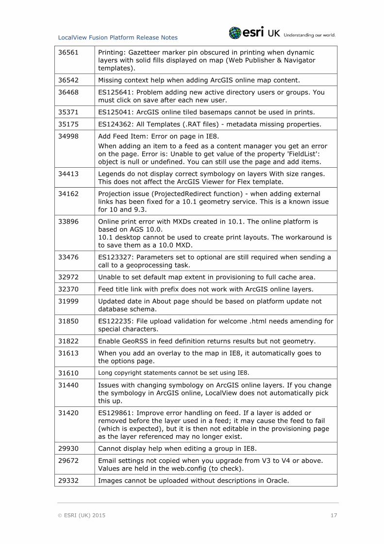
36561 Printing: Gazetteer marker pin obscured in printing when dynamic
layers with solid fills displayed on map (Web Publisher & Navigator
templates).
36542 Missing context help when adding ArcGIS online map content.
36468 ES125641: Problem adding new active directory users or groups. You
must click on save after each new user.
35371 ES125041: ArcGIS online tiled basemaps cannot be used in prints.
35175 ES124362: All Templates (.RAT files) - metadata missing properties.
34998 Add Feed Item: Error on page in IE8.
When adding an item to a feed as a content manager you get an error
on the page. Error is: Unable to get value of the property 'FieldList':
object is null or undefined. You can still use the page and add items.
34413 Legends do not display correct symbology on layers With size ranges.
This does not affect the ArcGIS Viewer for Flex template.
34162 Projection issue (ProjectedRedirect function) - when adding external
links has been fixed for a 10.1 geometry service. This is a known issue
for 10 and 9.3.
33896 Online print error with MXDs created in 10.1. The online platform is
based on AGS 10.0.
10.1 desktop cannot be used to create print layouts. The workaround is
to save them as a 10.0 MXD.
33476 ES123327: Parameters set to optional are still required when sending a
call to a geoprocessing task.
32972 Unable to set default map extent in provisioning to full cache area.
32370 Feed title link with prefix does not work with ArcGIS online layers.
31999 Updated date in About page should be based on platform update not
database schema.
31850 ES122235: File upload validation for welcome .html needs amending for
special characters.
31822 Enable GeoRSS in feed definition returns results but not geometry.
31613 When you add an overlay to the map in IE8, it automatically goes to
the options page.
31610 Long copyright statements cannot be set using IE8.
31440 Issues with changing symbology on ArcGIS online layers. If you change
the symbology in ArcGIS online, LocalView does not automatically pick
this up.
31420 ES129861: Improve error handling on feed. If a layer is added or
removed before the layer used in a feed; it may cause the feed to fail
(which is expected), but it is then not editable in the provisioning page
as the layer referenced may no longer exist.
29930 Cannot display help when editing a group in IE8.
29672 Email settings not copied when you upgrade from V3 to V4 or above.
Values are held in the web.config (to check).
29332 Images cannot be uploaded without descriptions in Oracle.
LocalView Fusion Platform Release Notes
ESRI (UK) 2015 18
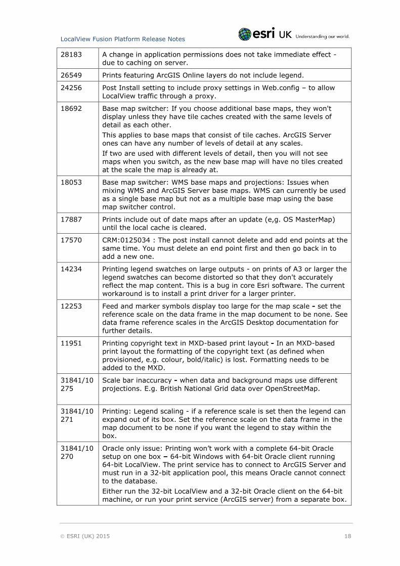
28183 A change in application permissions does not take immediate effect -
due to caching on server.
26549 Prints featuring ArcGIS Online layers do not include legend.
24256 Post Install setting to include proxy settings in Web.config – to allow
LocalView traffic through a proxy.
18692 Base map switcher: If you choose additional base maps, they won't
display unless they have tile caches created with the same levels of
detail as each other.
This applies to base maps that consist of tile caches. ArcGIS Server
ones can have any number of levels of detail at any scales.
If two are used with different levels of detail, then you will not see
maps when you switch, as the new base map will have no tiles created
at the scale the map is already at.
18053 Base map switcher: WMS base maps and projections: Issues when
mixing WMS and ArcGIS Server base maps. WMS can currently be used
as a single base map but not as a multiple base map using the base
map switcher control.
17887 Prints include out of date maps after an update (e,g. OS MasterMap)
until the local cache is cleared.
17570 CRM:0125034 : The post install cannot delete and add end points at the
same time. You must delete an end point first and then go back in to
add a new one.
14234 Printing legend swatches on large outputs - on prints of A3 or larger the
legend swatches can become distorted so that they don't accurately
reflect the map content. This is a bug in core Esri software. The current
workaround is to install a print driver for a larger printer.
12253 Feed and marker symbols display too large for the map scale - set the
reference scale on the data frame in the map document to be none. See
data frame reference scales in the ArcGIS Desktop documentation for
further details.
11951
Printing copyright text in MXD-based print layout - In an MXD-based
print layout the formatting of the copyright text (as defined when
provisioned, e.g. colour, bold/italic) is lost. Formatting needs to be
added to the MXD.
31841/10
275
Scale bar inaccuracy - when data and background maps use different
projections. E.g. British National Grid data over OpenStreetMap.
31841/10
271
Printing: Legend scaling - if a reference scale is set then the legend can
expand out of its box. Set the reference scale on the data frame in the
map document to be none if you want the legend to stay within the
box.
31841/10
270
Oracle only issue: Printing won’t work with a complete 64-bit Oracle
setup on one box – 64-bit Windows with 64-bit Oracle client running
64-bit LocalView. The print service has to connect to ArcGIS Server and
must run in a 32-bit application pool, this means Oracle cannot connect
to the database.
Either run the 32-bit LocalView and a 32-bit Oracle client on the 64-bit
machine, or run your print service (ArcGIS server) from a separate box.
LocalView Fusion Platform Release Notes
ESRI (UK) 2015 19
31841/10
267
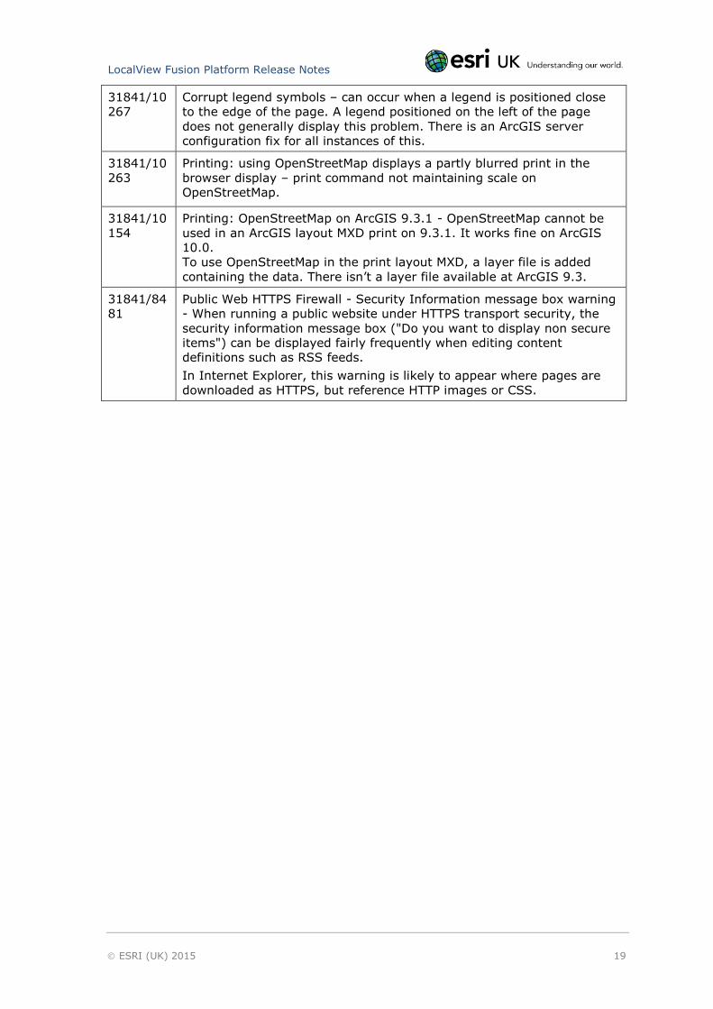
Corrupt legend symbols – can occur when a legend is positioned close
to the edge of the page. A legend positioned on the left of the page
does not generally display this problem. There is an ArcGIS server
configuration fix for all instances of this.
31841/10
263
Printing: using OpenStreetMap displays a partly blurred print in the
browser display – print command not maintaining scale on
OpenStreetMap.
31841/10
154
Printing: OpenStreetMap on ArcGIS 9.3.1 - OpenStreetMap cannot be
used in an ArcGIS layout MXD print on 9.3.1. It works fine on ArcGIS
10.0.
To use OpenStreetMap in the print layout MXD, a layer file is added
containing the data. There isn’t a layer file available at ArcGIS 9.3.
31841/84
81
Public Web HTTPS Firewall - Security Information message box warning
- When running a public website under HTTPS transport security, the
security information message box ("Do you want to display non secure
items") can be displayed fairly frequently when editing content
definitions such as RSS feeds.
In Internet Explorer, this warning is likely to appear where pages are
downloaded as HTTPS, but reference HTTP images or CSS.

LocalView Fusion Platform Release Notes
ESRI (UK) 2015 20
13. Help and Contact Information
13.1. Documentation
For instructions on how to install and configure LocalView Fusion, please see the
LocalView Fusion Installation Guide and the LocalView Fusion Implementation Guide.
For instructions on site provisioning, content publishing and administration of
LocalView Fusion please see the user help within the provisioning system.
For instructions on using Navigator, please see the Webhelp launched via the help
button in any Navigator application.
13.2. Contact
Esri UK provides extensive on-going support services to its customers. This service
covers:
Local support of Esri products
Support of Esri UK products
Support of bespoke applications developed by Esri UK
Support calls can be logged with Esri UK by contacting the Helpdesk:
Telephone: 01296 745555
Email: [email protected]
The support service is available 9.00 am to 5.30 pm Monday to Friday, excluding
English Public Holidays.
Support will require the specific build number of the LocalView version in order to
diagnose a problem. To retrieve the LocalView build number go to Support page of
the provisioning website, click on the About tab.


![Oracle Fusion Middleware Release Notes for Identity ... · PDF file[1]Oracle® Fusion Middleware Release Notes for Identity Management 11g Release 2 (11.1.2.3) E54495-09 December 2017](https://img.pdfslide.us/doc/110x75/5a9bf9a77f8b9ab6188dfb05/oracle-fusion-middleware-release-notes-for-identity-1oracle-fusion-middleware.jpg)


![[1]Oracle® Fusion Middleware Identity Management Release ... · [1]Oracle® Fusion Middleware Identity Management Release Notes 11g Release 2 (11.1.2) E35820-09 February 2015](https://img.pdfslide.us/doc/110x75/5b899fc07f8b9a287e8c9f45/1oracle-fusion-middleware-identity-management-release-1oracle-fusion.jpg)