Embed Size (px)
Citation preview
“Localising extensive urbanisation: comparing the emergence
of second-tier urban regions in Europe”
Rodrigo Viseu Cardoso
The Bartlett School of Planning UCL
5th floor Central House, 14 Upper Woburn Place
London WC1H 0NN
© by the author(s)
Paper presented at the RC21 International Conference on “The Ideal City: between myth and reality.
Representations, policies, contradictions and challenges for tomorrow's urban life” Urbino (Italy) 27-29
August 2015. http://www.rc21.org/en/conferences/urbino2015/
Rodrigo V Cardoso
2
Abstract
The end of cities as bounded entities and the generalisation of undirected, fragmented and
dispersed urbanisation processes are often interpreted as pertaining mostly to the second half
of the 20th century, leading to the assumption that earlier stages of urbanisation were
dominated by centrifugal core city expansion. This may be due to a relative neglect by urban
studies of the role of urban fragments outside core cities as early producers of multiple and
simultaneous processes of expansion, densification and dispersion. Nevertheless these
processes of extensive urbanisation left behind forms and networks that coexist with
contemporary urbanisation, despite the tendency of massive core city expansion to override
them. Acknowledging this tension adds local specificity to the generic and travelling models
that often underpin research on extensive urbanisation. Moreover, urban regions where this
process has been more visible may have developed different morphological, functional, cultural
and political features than those broadly following a linear timeline of core city decentralisation
over an assumed urban void. Exploring these differences helps to understand the different
functional, spatial and institutional configurations of urban regions.
Second-tier cities produce and are embedded in extensive urban regions but their history of
lesser impact over surrounding centres and weaker core-periphery functional hierarchies, when
compared with dominant primate cities, may have preserved more traces of these early forms
of extensive urbanisation. Their particular case is explored through a long-term analysis of how
their urban regions emerged based on detailed population data between 1890 and 2011 in
three European second-tier cities: Porto, Bristol and Antwerp. The indicators illustrate the
progression of the urban-rural divide, population growth rates in different locations and
relations between distance to core city and growth. The results reveal a trajectory of erratic
metropolitan growth mixed with densification of loose urban fragments spread across the
territory, following simultaneous and contradictory trends of expansion, dispersion and
densification in different locations. The assumption of a linear timeline of centripetal and
centrifugal forces emanating from the core city may not tell the whole story of the early
emergence of urban regions and this may particularly clear in second-tier cities. This suggests a
different interpretation of what is indeed ‘new’ about extensive urbanisation processes and
argues the need for precision and historical specificity in the application of general frameworks
of analysis. Finally, a discussion is proposed about how the implications of such a trajectory to
current functional and institutional arrangements in second-tier urban regions.
Rodrigo V Cardoso
3
1. Introduction: a long-term view of extensive urbanisation
“[The South West region] is full of rivers and towns and infinitely populous […]
interspersed with a great number of villages, I had almost said innumerable
villages, hamlets and scattered houses […].” Daniel Defoe, cited in Barry, 2000: 81
"The province [northwest Portugal] is the smallest in the land but has been
growing the most in terms of population: […]. It has no more than three cities and
twenty-five towns; however, the villages and hamlets are so numerous, that it
looks like a continuous city […].” Silveira, 1789
The last few decades saw the emergence of a growing set of literature describing the end of
cities as bounded and discernible entities and the generalisation of undirected, fragmented
and dispersed urbanisation processes of territorial scale, shifting the matter of concern of
urban studies from the ‘city’ to the city-region, city-territory, urban region, urban landscape,
and a plethora of neologisms trying to define the new entities taking shape (Gottmann, 1961;
Friedmann, 1978; Sudjic, 1992; Ascher, 1995; Sieverts, 1997; Soja, 2000; Nello, 2001; Hall and
Pain, 2006; Schmid, 2006; Katz and Bradley, 2013; Brenner, 2014). In Europe, particularly in
southern countries, the term ‘extensive urbanisation’ has been used (Portas et al., 2007; Font,
2004; Grosjean, 2010), as an umbrella term for the large-scale processes of territorial
reconfiguration, in which new land uses, functions, people and activities penetrate urban and
rural areas alike, beyond centre-periphery hierarchies and predefined urban centres.
‘Extensive’ is suggested in opposition to ‘intensive’ urbanisation processes, characterised by
physical expansion of central cities into dense built-up agglomerations over a relatively non-
problematised void (the ‘empty’ countryside), driven by heavy infrastructure and large-scale
planning, and following a linear and socially differentiated chronology of urbanisation,
suburbanisation and disurbanisation (Berg et al. 1982). By contrast, the ‘extensive’ is mostly
polycentric, undirected and fragmented (Schmid, 2006), allows simultaneous contrary trends
rather than a life-cycle of successive stages (Soja, 2000; 2011), grows by colonising existing
infrastructure like a ‘fluid percolating through a sponge’ (Secchi, 1989), and is often erratically
induced by the attractive force of large functional concentrations rather than any plan-based
expansion (Sudjic, 1992). Spatial patterns become blurred and changeable, and planning tools
try to keep up rather than prepare the ground for urban development (Sieverts, 1997).
Rodrigo V Cardoso
4
This stage of urbanisation, replacing the urban-rural divide by an ubiquitous ‘urban field’
(Friedmann, 1978) and giving rise to a coalescence of the meanings of ‘city’ and ‘region’, is
broadly considered as pertaining to the second half of the 20th century. However, much earlier
than that, descriptions by travellers and attentive observers of populous ‘continuous cities’
made of ‘innumerable villages and hamlets’ highlighted that the presence of urban patterns
and ways of life on the territory was becoming more and more dominant. Admittedly, the
scale of urbanisation has changed in the last 50 years, from a ‘pointillist’ and dispersed fabric
of buildings and localised connections to a much heavier system based on large infrastructural
axes and functional concentrations. But in many cases, like the ones illustrated by the 18th-
century quotes above, the seeds of erratic and fragmented urbanisation processes gradually
humanising places, creating landmarks and overriding clear urban-rural divisions were in place,
both in ‘cities’ and ‘non-cities’, at an earlier stage than much urban literature, with its
embedded “methodological cityism” (Brenner, 2014: 15), is ready to acknowledge.
Indeed, the further we go back in time, the more difficult it becomes to tell the story of
territories outside core cities. Data is scarce, mapping and imagery is not accurate, and the
history of their urbanisation falls outside the proper history of urbanism (Grosjean, 2010). In
fact, such territories were not, until recently, sufficiently problematised by the discipline of
urban studies. To start, urbanisation outside core cities lacked proper planning and
consequently an interpretative framework as a (proto-)urban setting. Mapping such places was
more the concern of military authorities than urban scholars. Only in the twentieth century has
the problem of urbanisation been applied the territory as a whole, which led to assumptions,
still present today, that places outside core cities are a ‘recent’ urban problem only because
they appeared recently in the field of urban studies (Grosjean, op.cit.).
This led to a notion of urban growth as a city expanding over an assumed and unproblematic
spatial-historical void – and that void was gradually occupied by ‘suburbs’, equally perpetuated
as theoretically generic, a-historical and generally unproblematic (Vaughan et al., 2009). This
devaluation of the role of places outside core cities in the historical process of urbanisation
found its correlate in the way many authors have equally devalued these urban spaces as
something lesser than ‘the city’. Phelps notes how “post-suburban development has been
defined in relation to something considered the city proper – whether broadly ‘good’ or ‘bad’ –
since at least medieval times” (Phelps et al., 2006: 9). As the distinction between city and
periphery dissolves into a single entity, we have “urbanisation but not city” (Nello, 2001: 13).
Rodrigo V Cardoso
5
The different routes towards the urban region
Largely ignoring the role of places outside the largest core cities as early sources of undirected
and polycentric urbanisation processes, rather than empty spaces awaiting urban expansion,
‘methodological cityism’ has great difficulty in departing from the core-periphery centrifugal
models assumed as the default trajectory of urban growth. In fact, the ‘city region’ is often
defined as the outcome of the diffusion and relocation of core city activity, “a long process of
very extended decentralisation from big central cities to adjacent smaller ones, old and new”
(Hall and Pain, 2006: 3). But such a centrifugal expansion process from a monocentric city into
a polycentric configuration is by no means the only possible route to an urban region; if the
specificity and variability of individual cases is taken into account, beyond generic and
universal models, we are necessarily confronted with the notion that, in terms of historical
trajectory and contemporary configurations of urbanisation, one size does not fit all.
In an effort to provide a more nuanced model, A. G. Champion (2001) proposes a three-tier
typology of centrifugal, incorporation and fusion modes for the emergence of polycentric
urban regions. The centrifugal and fusion modes roughly express the accepted distinction
between the progressive outward expansion of large primate cities over their comparatively
‘empty’ hinterland, arguably the case of Greater London, Paris or Madrid (Lambregts, 2006),
and the convergence of separate centres of similar size into a single urban system, typically
illustrated by the Randstad or RhineRuhr (ibid.). The incorporation mode, on the other hand,
corresponds to a mixed trajectory of core city expansion blending with the densification and
merger of pre-existing smaller urban centres and fragments spread across the region.
Whatever route an urban region has followed, and disregarding the problems of this simplified
model (urban regions will exhibit different tendencies across their history) this framework of
differentiation reminds us that “pre-existing forms of settlement can influence subsequent
patterns of development.” (Champion, 2001: 665). Pre-existing differences have an influence
on the cultural and political identity of a region and on the consolidation of contemporary
patterns of infrastructure, urban functions and urban forms, as they are “superimposed on
inherited physical structures, property rights and network linkages.” (ibid.). Knowing whether
urban regions emerged as the result of a broadly centrifugal, fusion or incorporation process
helps us make sense of the visible differences between them (Lambregts, 2006), and uncover
the strengths and weaknesses of the territory: the identification of its features will allow a
“good use of the opportunities presented by the spatial structure itself” (Font, 2004: 331).
Rodrigo V Cardoso
6
Looking for traces of early urbanisation: a research hypothesis
Despite the traces and superimpositions they have left behind, such loose and localised
processes of in situ urbanisation were often countered, and sometimes totally obliterated, by
the large-scale expansion of dominant core cities and contemporary urbanisation modes.
However, the extent to which they could be overridden, and how much their traces have
disappeared, is related to the scale and speed of expansion of core cities and their influence on
the development of the surrounding urban region. In other words, it is likely that the different
routes towards the urban region theorised by Champion had different impacts on these fragile
and place-specific processes, and on the role they play in contemporary configurations. In this
respect, earlier literature hints at particularly relevant differences between large primate cities
and smaller second-tier cities, such as Hohenberg’s view of capitals growing in a ‘central place’
framework and smaller cities developing in a network model (2004), or the distinction
between hierarchic ‘spiderweb metropolises’ around ‘first order’ dominant cities and ‘network
metropolises’ elsewhere, proposed by Heynen, Loecks and Smets (1991).
The common feature of these descriptions is that ‘first order’ cities tend to play a historically
dominant role in their urban regions, which are assumed to evolve from a monocentric to a
polycentric condition based on relocation of activity as core cities project their large-scale
political and economic expansion agenda over a relatively ‘passive’ hinterland (Barry, 2000).
This is a fundamentally core-dependent, hierarchic and progressive process, but one that only
cities large enough to first attract or aggregate a large amount of functions, people and
activities were then able to trigger. As a result, such cities will be able to influence accordingly
the socio-economic, functional and spatial configurations at the urban region scale, and form
hierarchic relations with the secondary centres in their hinterland (Phelps et al., 2006). Such a
process, closer to Champion’s centrifugal mode, is likely to have erased more autonomous and
smaller-scale forms of urbanisation elsewhere in the urban region.
Conversely, in other cities lacking both the attractive pull to gather and redistribute functions
and activities, as well as the ability to override divergent local configurations and define a
functional and spatial hierarchy for the larger region, centrifugal processes played a lesser role
in constraining the trajectory towards the urban region. Places less subject to core-periphery
hierarchies may therefore have built a functionally and spatially more fragmented urban
system, with important urban functions emerging at different points of the territory not
necessarily through decentralisation, making the city vs. hinterland contrast less visible than in
Rodrigo V Cardoso
7
the case above. Note that this does not describe ‘polycentric urban regions’ based on separate
centres of equivalent size (Klosterman and Musterd, 2001; Parr, 2004): between them and the
hegemonic primate cities described above, there is a world of medium-sized, second-tier cities,
which do not play dominant roles in the functional, demographic or socio-economic structure
of the wider hinterland, but are nevertheless the main cities of the urban region.
This development mode is arguably closer to Champion’s incorporation mode, in which smaller
centres have hosted and retained their own set of jobs and services regardless of core city
expansion, and form “a more powerful catalyst for attracting extra non-residential activities
than the centres emerging through the centrifugal mode” (Champion, 2001: 664). The
emerging hypothesis is that, whatever the early forms of urbanisation in place, this route of
urban region formation has done less to erase their place-specific traces than the development
of primate cities, as the intensive and large-scale centrifugal forms of expansion did not have
the reach and strength to fully override historical peculiarities and local configurations.
In summary, this paper tries to address several questions:
- Can the analysis of the emergence of urban regions in second-tier cities reveal a trajectory
somewhere between the centrifugal expansion mode of dominant core cities and the
fusion mode in polycentric urban regions, broadly consistent with the incorporation mode?
- Can such a non-centrifugal and less intensive expansion mode be less destructive of local
configurations and historical peculiarities and actually preserve the traces of this trajectory?
- And finally, can an interpretative lens which abandons the constraints of ‘methodological
cityism’ and core-periphery assumptions help illuminate the role of all places within the
urban as sources of early urbanisation processes?
The analysis aims to add nuance and specificity to existing models describing the historical
processes of extensive urbanisation; to discuss the compartmentalised timeline of the
different stages of urbanisation, highlighting simultaneity and mixed trends; and to confront
dominant core-periphery views of urbanisation as initially related to the outward expansion of
a core city gradually decentralising into an urban region, producing other important cores in
the process. The next section describes the methodology used, followed by the results
obtained for three case studies, a discussion of their implications both for research
methodologies and the theoretical framework, and finally some conclusions about second-tier
city development modes and the possible directions of future research.
Rodrigo V Cardoso
8
2. Methodology
To achieve the purposes above, a diachronic analysis of long-term urbanisation patterns based
on population change (1890-2011) in three European second-tier urban regions will be used. A
view covering such a long period is important for two reasons:
- In theoretical terms, it directly confronts the notion that dispersed urbanisation and
undirected, fragmented urban expansion are ‘recent’ processes or ‘final’ stages of urban
growth (Keil, 1994; Schmid, 2006). Several related questions emerge here: did the 20th
century always correspond to the emptying out of rural territories and exodus towards core
cities followed by a centrifugal process of suburbanisation? Are processes of dispersion
recent because they correspond to the generalisation of the private car? And do different
modes of urban expansion necessarily correspond to different and sequential time periods?
- Methodologically, it highlights place-specific processes that were in place long before the
discipline of urban studies started to look at places outside core cities. Place-specific
differences have arguably a greater influence on modes of urbanisation than general
similarities (Salvati and De Rosa, 2014). In fact, research has produced many different
descriptions of extensive urbanisation, which are, with some exceptions, local syntheses
(hence keeping the terms in their original language) rather than grand theories:
Zwischenstadt, Cittá Diffusa, Randstad, Hyperville, 100-mile City, or Postmetropolis are all
describing different places. Urban theory is recent but urbanised territories are ancient and
a long-term view helps to avoid ‘travelling theory’ (McNeill, 1999).
Case studies
The three second-tier cities – Porto (Portugal), Antwerp (Belgium) and Bristol (United
Kingdom) were chosen according to two criteria:
- They should be second-tier cities, i.e. not political capitals or the largest national cities,
preferably in countries where the contrast with a dominant capital is visible from important
political, economic or functional imbalances. The recent ESPON report on second tier cities
(2012) clearly situates these three cities in such a context.
- They should be embedded in a dense urban region with a polycentric and dispersed
structure, being its institutional or cultural core but not functionally and demographically
Rodrigo V Cardoso
9
hegemonic – i.e. neither primate cities nor part of a ‘classic’ polycentric urban region. Porto
and Antwerp have been described as part of an extensive and fragmented ‘diffuse city’
(Meulder et al., 1999, 2008; Grosjean, 2010; Portas et al., 2007; Domingues, 2008).
Development in Bristol has been more contained historically, but it is the UK region where
the shift to polycentricity has been stronger in recent years (Burger et al., 2011).
The study area is broadly defined as the ‘urban region’, following the ESPON 1.4.3 report
(2007) that determines criteria to compose Functional and Morphological Urban Regions (FUA
and MUA). The Porto urban region includes five MUAs within a polycentric FUA. It covers a
surface area of 2,524 km2 and a population of 2,018,402 (2011). Administratively, it includes
238 LAU2 units (freguesias, the lowest sub-municipal division) in the Porto Metropolitan Area
and surrounding areas. The Bristol region has four MUAs in one FUA, with 1,579 km2 and
1,094,957 inhabitants (2011). The study area is composed by 153 LAU2 units (wards), in the
City of Bristol, Bath and North East Somerset, North Somerset and South Gloucestershire. The
Antwerp urban region includes two MUAs and covers 1,831 km2, with a population of
1,451,802 (2011). It includes 50 LAU2 units mainly in the Antwerp province.
Data and Indicators
Due to the methodological cityism discussed above, largely neglecting the role of places
outside core cities in early urbanisation, the study of the urban region scale has embedded
difficulties of precision and data availability. The problem is how to look at long-term
processes in large urban regions with the same level of precision as in core cities. Additionally,
we need data that is available and can be compared for the three case studies. Indicators
normally used in comparisons of urban development, like land use, extension of built up fabric,
etc., only exist with sufficient accuracy since the 1950s (EEA, 2002; Kasanko et al., 2006).
However, population data goes much farther back, to the times when national authorities
started systematically gathering census data.
Using population data to understand urban change has advantages and limitations. The
important point is that, while absolute population numbers say little about the problem,
population change is seen as both an influence in and consequence of urban conditions:
“Migration is a response to differences in employment or the quality of life between places,
even if the process of adjustment is inefficient.” (Turok and Mikhnenko, 2007: 167). Population
Rodrigo V Cardoso
10
data also allows direct and accessible comparisons between different contexts. The main
problem of such analyses, namely the arbitrary definition of spatial units (administrative areas)
is partially averted by focusing on the smallest possible unit (LAU2): extreme variability of unit
size and inaccuracies brought by density and settlement pattern variations inside larger units
are thus kept under control. Naturally, more precise units used in contemporary
measurements, such as 1km2 grids, are also not available for a long term analysis.
While in Porto and Antwerp LAU2 units have remained rather stable throughout the years (an
exception is the annexation of several districts by the City of Antwerp in 1983, leading to a
great increase of population), the successive administrative definitions and boundary changes
in the UK make the Bristol case less reliable. Nevertheless, a great effort was made to access
historical data for each parish/ward/local government district and to attribute the most
extreme population changes to boundary changes rather than explosive urban growth. Despite
that, a few values for Bristol are estimates: when the LAU2-equivalent data was truly
inaccessible for a given area, the averages of the higher boundary were used.
Five census years with approximately 30-year intervals are used from 1890 to 2011. Data was
gathered from a variety of sources: for Porto, all census documents are available online from
the National Statistics Institute. For Bristol, data for 2011 is also available online at the Office
for National Statistics; older data was mainly gathered from the ‘A Vision of Britain’ database,
run by the University of Portsmouth. For Antwerp, data was gathered from the Belgian
Statistics Institute, as published by other online sources. The indicators and maps used for the
long-term analysis are the following:
1. Map of areas over the 300 inh./km2 threshold defined by Eurostat as the urban/rural divide
(for current conditions): this will assess the areas undergoing early urbanisation, their
change over time and relation to the expansion process of the main urban cores.
2. Graph of population growth 1890-2011 by geographical area (core city, MUA, FUA): this will
check the long-term dynamics, trends for simultaneity and mutual relations between core
city expansion, urban fringe growth, and peri-urban discontinuous urbanisation processes.
3. Map of population growth ratio by LAU2 unit: related to the former two indicators, this
allows the visualisation of population growth ‘hotspots’ according to their location in the
urban region and relates the findings of 1) and 2) above.
Rodrigo V Cardoso
11
4. Graph of population growth ratio as a function of distance to core city (polynomial
regression), according to geographical area, and comparing the 1890-1950 and 1950-2011
periods for the whole urban region: this will assess how the distance to the core city
influenced the pace of urbanisation elsewhere, whether specific areas followed
independent agendas, and how this changed over time.
3. Results and findings
In this section long-term population change and the spatial organisation of urban regions are
analysed based on the indicators above. The results for each are discussed separately.
3.1 Urban vs. rural areas: the early seeds of the urban region
Eurostat uses the 300 inh./km2 threshold to separate urban and rural areas for statistical
purposes. It applies that value to a grid of 1km2 cells and then groups them into continuous
units with more than 5,000 people to define morphological urban areas. Here, the same
density threshold is used to classify LAU2 units as far back as 1890 to verify what areas in the
region could already be considered ‘urban’ by today’s standards. The purpose is to locate the
origins of urban expansion in each urban region and their change over time, confronting the
notion of a dominant city expanding onto a void.
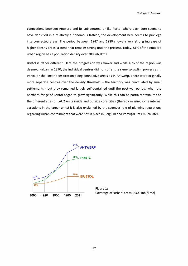
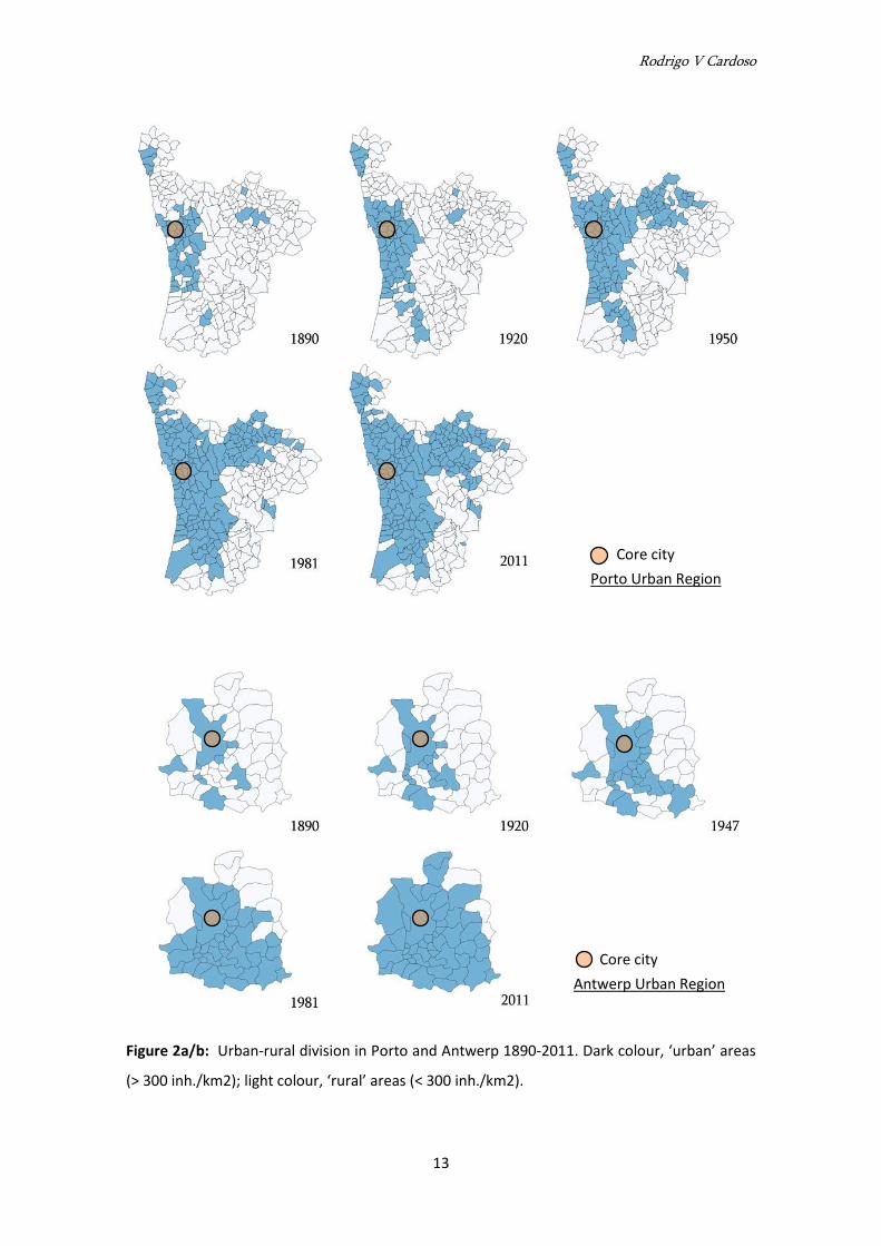
In Porto, the seeds of the present MUAs were already present in 1890. The ‘urban’ covered
16% of the region in four main high-density cores, including the central agglomeration where
the limits of the core city had already been dissolved as far as the urban-rural divide is
concerned. By 1920 the main evolution had taken place in this agglomeration, gradually
consolidating and eventually integrating with the MUAs to the South and East by 1950. In
1981, 56% of the urban region was over the 300 inh./km2 limit, growing smoothly to 60% in
2011 – note that this is a very large region including remote rural areas. Rather than the
expansion of a dominant core, the urban-rural divide was surpassed by the growth and
coalescence of several sub-centres.
The case of Antwerp reveals a similar evolution until 1950, followed by quicker growth in the
later period. There were also four density cores in 1890, but more closely knitted than in Porto
(which is a larger region). The density threshold was first surpassed along relatively linear
Rodrigo V Cardoso
12
connections between Antwerp and its sub-centres. Unlike Porto, where each core seems to
have densified in a relatively autonomous fashion, the development here seems to privilege
interconnected areas. The period between 1947 and 1980 shows a very strong increase of
higher density areas, a trend that remains strong until the present. Today, 81% of the Antwerp
urban region has a population density over 300 inh./km2.
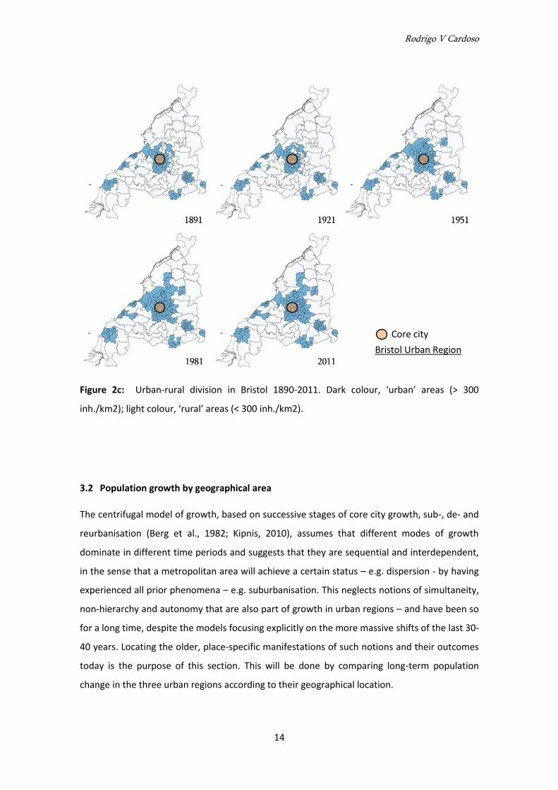
Bristol is rather different. Here the progression was slower and while 16% of the region was
deemed ‘urban’ in 1890, the individual centres did not suffer the same sprawling process as in
Porto, or the linear densification along connective areas as in Antwerp. There were originally
more separate centres over the density threshold – the territory was punctuated by small
settlements - but they remained largely self-contained until the post-war period, when the
northern fringe of Bristol began to grow significantly. While this can be partially attributed to
the different sizes of LAU2 units inside and outside core cities (thereby missing some internal
variations in the larger units) it is also explained by the stronger role of planning regulations
regarding urban containment that were not in place in Belgium and Portugal until much later.
Figure 1: Coverage of ‘urban’ areas (>300 inh./km2)
Rodrigo V Cardoso
13
Figure 2a/b: Urban-rural division in Porto and Antwerp 1890-2011. Dark colour, ‘urban’ areas
(> 300 inh./km2); light colour, ‘rural’ areas (< 300 inh./km2).
Core city
Porto Urban Region
Core city
Antwerp Urban Region
Rodrigo V Cardoso
14
Figure 2c: Urban-rural division in Bristol 1890-2011. Dark colour, ‘urban’ areas (> 300
inh./km2); light colour, ‘rural’ areas (< 300 inh./km2).
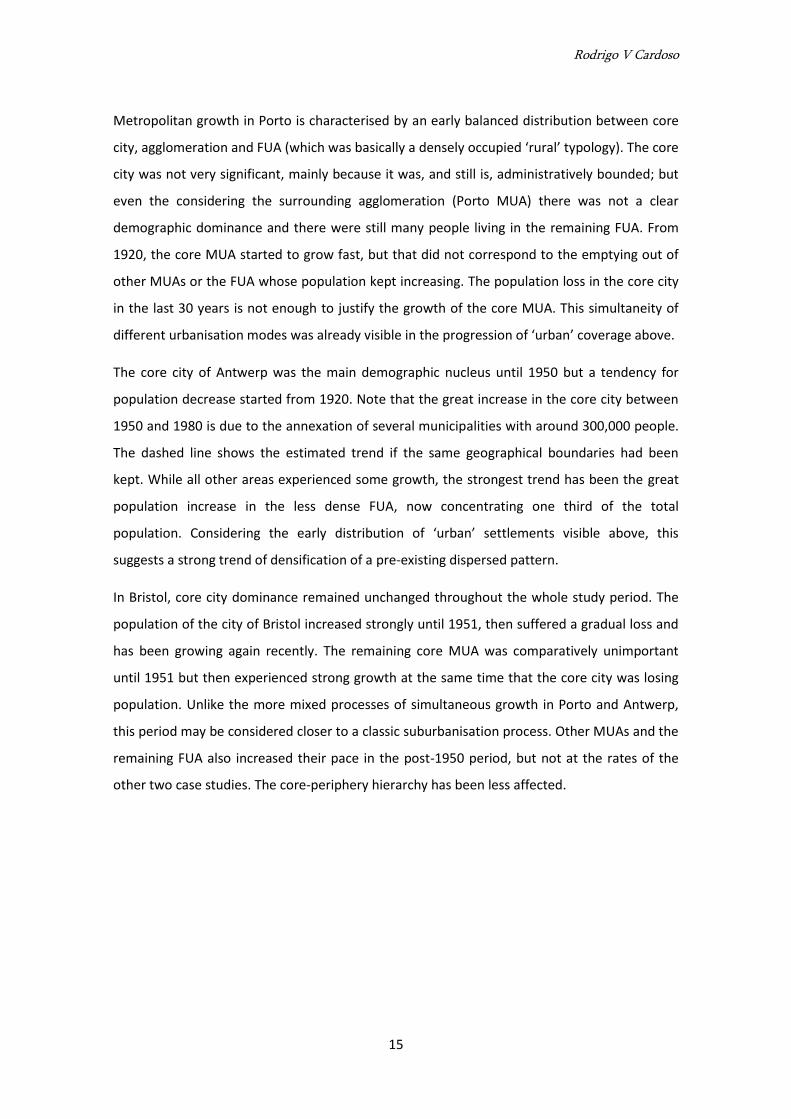
3.2 Population growth by geographical area
The centrifugal model of growth, based on successive stages of core city growth, sub-, de- and
reurbanisation (Berg et al., 1982; Kipnis, 2010), assumes that different modes of growth
dominate in different time periods and suggests that they are sequential and interdependent,
in the sense that a metropolitan area will achieve a certain status – e.g. dispersion - by having
experienced all prior phenomena – e.g. suburbanisation. This neglects notions of simultaneity,
non-hierarchy and autonomy that are also part of growth in urban regions – and have been so
for a long time, despite the models focusing explicitly on the more massive shifts of the last 30-
40 years. Locating the older, place-specific manifestations of such notions and their outcomes
today is the purpose of this section. This will be done by comparing long-term population
change in the three urban regions according to their geographical location.
Core city
Bristol Urban Region
Rodrigo V Cardoso
15
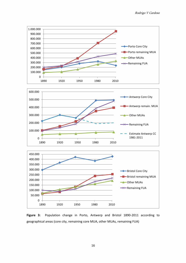
Metropolitan growth in Porto is characterised by an early balanced distribution between core
city, agglomeration and FUA (which was basically a densely occupied ‘rural’ typology). The core
city was not very significant, mainly because it was, and still is, administratively bounded; but
even the considering the surrounding agglomeration (Porto MUA) there was not a clear
demographic dominance and there were still many people living in the remaining FUA. From
1920, the core MUA started to grow fast, but that did not correspond to the emptying out of
other MUAs or the FUA whose population kept increasing. The population loss in the core city
in the last 30 years is not enough to justify the growth of the core MUA. This simultaneity of
different urbanisation modes was already visible in the progression of ‘urban’ coverage above.
The core city of Antwerp was the main demographic nucleus until 1950 but a tendency for
population decrease started from 1920. Note that the great increase in the core city between
1950 and 1980 is due to the annexation of several municipalities with around 300,000 people.
The dashed line shows the estimated trend if the same geographical boundaries had been
kept. While all other areas experienced some growth, the strongest trend has been the great
population increase in the less dense FUA, now concentrating one third of the total
population. Considering the early distribution of ‘urban’ settlements visible above, this
suggests a strong trend of densification of a pre-existing dispersed pattern.
In Bristol, core city dominance remained unchanged throughout the whole study period. The
population of the city of Bristol increased strongly until 1951, then suffered a gradual loss and
has been growing again recently. The remaining core MUA was comparatively unimportant
until 1951 but then experienced strong growth at the same time that the core city was losing
population. Unlike the more mixed processes of simultaneous growth in Porto and Antwerp,
this period may be considered closer to a classic suburbanisation process. Other MUAs and the
remaining FUA also increased their pace in the post-1950 period, but not at the rates of the
other two case studies. The core-periphery hierarchy has been less affected.
Rodrigo V Cardoso
16
Figure 3: Population change in Porto, Antwerp and Bristol 1890-2011 according to
geographical areas (core city, remaining core MUA, other MUAs, remaining FUA)
0
100.000
200.000
300.000
400.000
500.000
600.000
700.000
800.000
900.000
1.000.000
1890 1920 1950 1980 2010
Porto Core City
Porto remaining MUA
Other MUAs
Remaining FUA
0
100.000
200.000
300.000
400.000
500.000
600.000
1890 1920 1950 1980 2010
Antwerp Core City
Antwerp remain. MUA
Other MUAs
Remaining FUA
Estimate Antwerp CC 1981-2011
0
50.000
100.000
150.000
200.000
250.000
300.000
350.000
400.000
450.000
1890 1920 1950 1980 2010
Bristol Core City
Bristol remaining MUA
Other MUAs
Remaining FUA
Rodrigo V Cardoso
17
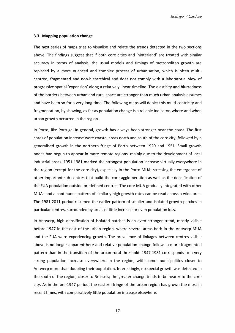
3.3 Mapping population change
The next series of maps tries to visualise and relate the trends detected in the two sections
above. The findings suggest that if both core cities and ‘hinterland’ are treated with similar
accuracy in terms of analysis, the usual models and timings of metropolitan growth are
replaced by a more nuanced and complex process of urbanisation, which is often multi-
centred, fragmented and non-hierarchical and does not comply with a laboratorial view of
progressive spatial ‘expansion’ along a relatively linear timeline. The elasticity and blurredness
of the borders between urban and rural space are stronger than much urban analysis assumes
and have been so for a very long time. The following maps will depict this multi-centricity and
fragmentation, by showing, as far as population change is a reliable indicator, where and when
urban growth occurred in the region.
In Porto, like Portugal in general, growth has always been stronger near the coast. The first
cores of population increase were coastal areas north and south of the core city, followed by a
generalised growth in the northern fringe of Porto between 1920 and 1951. Small growth
nodes had begun to appear in more remote regions, mainly due to the development of local
industrial areas. 1951-1981 marked the strongest population increase virtually everywhere in
the region (except for the core city), especially in the Porto MUA, stressing the emergence of
other important sub-centres that build the core agglomeration as well as the densification of
the FUA population outside predefined centres. The core MUA gradually integrated with other
MUAs and a continuous pattern of similarly high growth rates can be read across a wide area.
The 1981-2011 period resumed the earlier pattern of smaller and isolated growth patches in
particular centres, surrounded by areas of little increase or even population loss.
In Antwerp, high densification of isolated patches is an even stronger trend, mostly visible
before 1947 in the east of the urban region, where several areas both in the Antwerp MUA
and the FUA were experiencing growth. The prevalence of linkages between centres visible
above is no longer apparent here and relative population change follows a more fragmented
pattern than in the transition of the urban-rural threshold. 1947-1981 corresponds to a very
strong population increase everywhere in the region, with some municipalities closer to
Antwerp more than doubling their population. Interestingly, no special growth was detected in
the south of the region, closer to Brussels; the greater change tends to be nearer to the core
city. As in the pre-1947 period, the eastern fringe of the urban region has grown the most in
recent times, with comparatively little population increase elsewhere.
Rodrigo V Cardoso
18
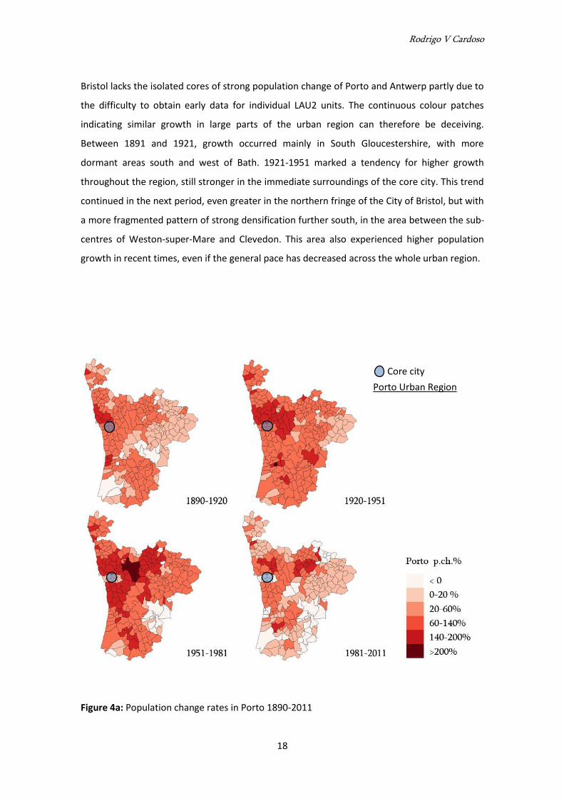
Bristol lacks the isolated cores of strong population change of Porto and Antwerp partly due to
the difficulty to obtain early data for individual LAU2 units. The continuous colour patches
indicating similar growth in large parts of the urban region can therefore be deceiving.
Between 1891 and 1921, growth occurred mainly in South Gloucestershire, with more
dormant areas south and west of Bath. 1921-1951 marked a tendency for higher growth
throughout the region, still stronger in the immediate surroundings of the core city. This trend
continued in the next period, even greater in the northern fringe of the City of Bristol, but with
a more fragmented pattern of strong densification further south, in the area between the sub-
centres of Weston-super-Mare and Clevedon. This area also experienced higher population
growth in recent times, even if the general pace has decreased across the whole urban region.
Figure 4a: Population change rates in Porto 1890-2011
Core city
Porto Urban Region
Rodrigo V Cardoso
19
Figure 4b/c: Population change rates in Antwerp and Bristol 1890-2011
Core city
Antwerp Urban Region
Core city
Bristol Urban Region
Rodrigo V Cardoso
20
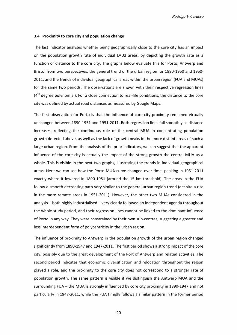
3.4 Proximity to core city and population change
The last indicator analyses whether being geographically close to the core city has an impact
on the population growth rate of individual LAU2 areas, by depicting the growth rate as a
function of distance to the core city. The graphs below evaluate this for Porto, Antwerp and
Bristol from two perspectives: the general trend of the urban region for 1890-1950 and 1950-
2011, and the trends of individual geographical areas within the urban region (FUA and MUAs)
for the same two periods. The observations are shown with their respective regression lines
(4th degree polynomial). For a close connection to real-life conditions, the distance to the core
city was defined by actual road distances as measured by Google Maps.
The first observation for Porto is that the influence of core city proximity remained virtually
unchanged between 1890-1951 and 1951-2011. Both regression lines fall smoothly as distance
increases, reflecting the continuous role of the central MUA in concentrating population
growth detected above, as well as the lack of growth peaks in the more distant areas of such a
large urban region. From the analysis of the prior indicators, we can suggest that the apparent
influence of the core city is actually the impact of the strong growth the central MUA as a
whole. This is visible in the next two graphs, illustrating the trends in individual geographical
areas. Here we can see how the Porto MUA curve changed over time, peaking in 1951-2011
exactly where it lowered in 1890-1951 (around the 15 km threshold). The areas in the FUA
follow a smooth decreasing path very similar to the general urban region trend (despite a rise
in the more remote areas in 1951-2011). However, the other two MUAs considered in the
analysis – both highly industrialised – very clearly followed an independent agenda throughout
the whole study period, and their regression lines cannot be linked to the dominant influence
of Porto in any way. They were constrained by their own sub-centres, suggesting a greater and
less interdependent form of polycentricity in the urban region.
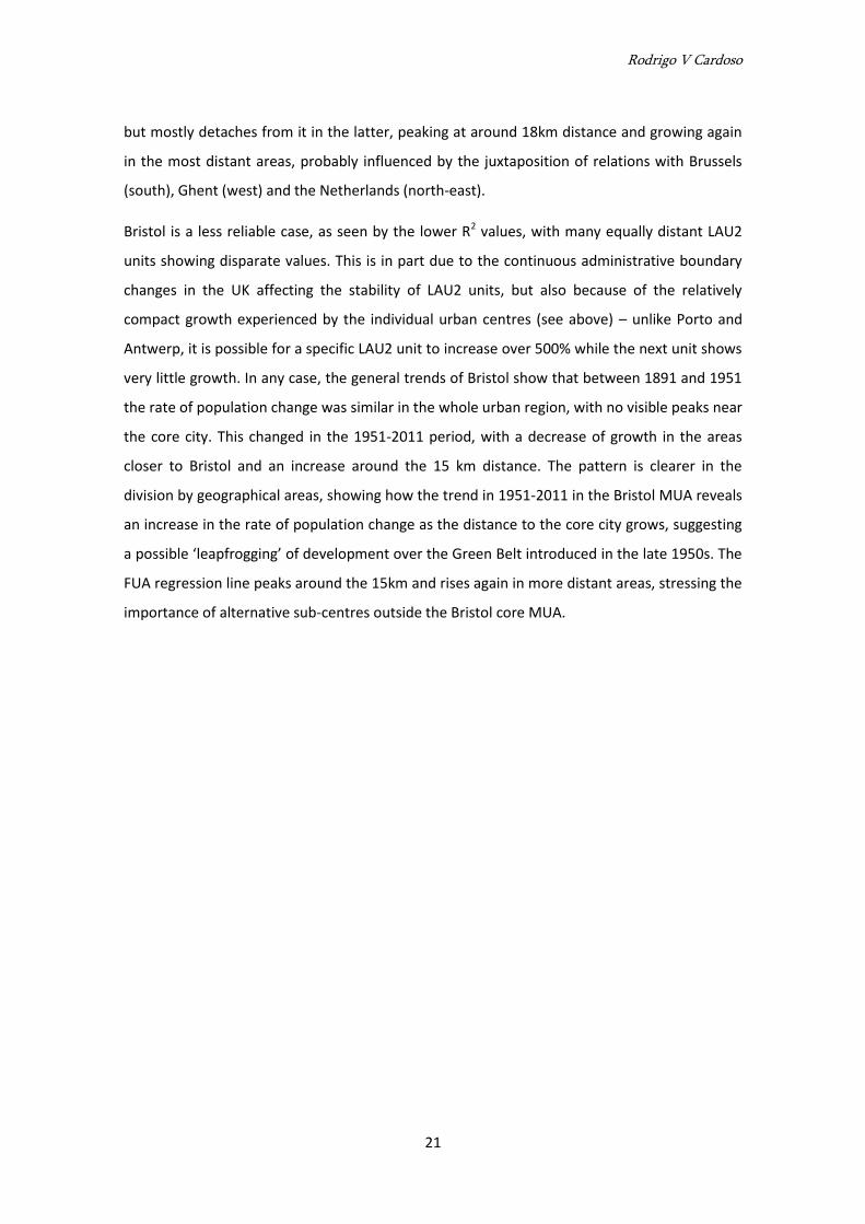
The influence of proximity to Antwerp in the population growth of the urban region changed
significantly from 1890-1947 and 1947-2011. The first period shows a strong impact of the core
city, possibly due to the great development of the Port of Antwerp and related activities. The
second period indicates that economic diversification and relocation throughout the region
played a role, and the proximity to the core city does not correspond to a stronger rate of
population growth. The same pattern is visible if we distinguish the Antwerp MUA and the
surrounding FUA – the MUA is strongly influenced by core city proximity in 1890-1947 and not
particularly in 1947-2011, while the FUA timidly follows a similar pattern in the former period
Rodrigo V Cardoso
21
but mostly detaches from it in the latter, peaking at around 18km distance and growing again
in the most distant areas, probably influenced by the juxtaposition of relations with Brussels
(south), Ghent (west) and the Netherlands (north-east).
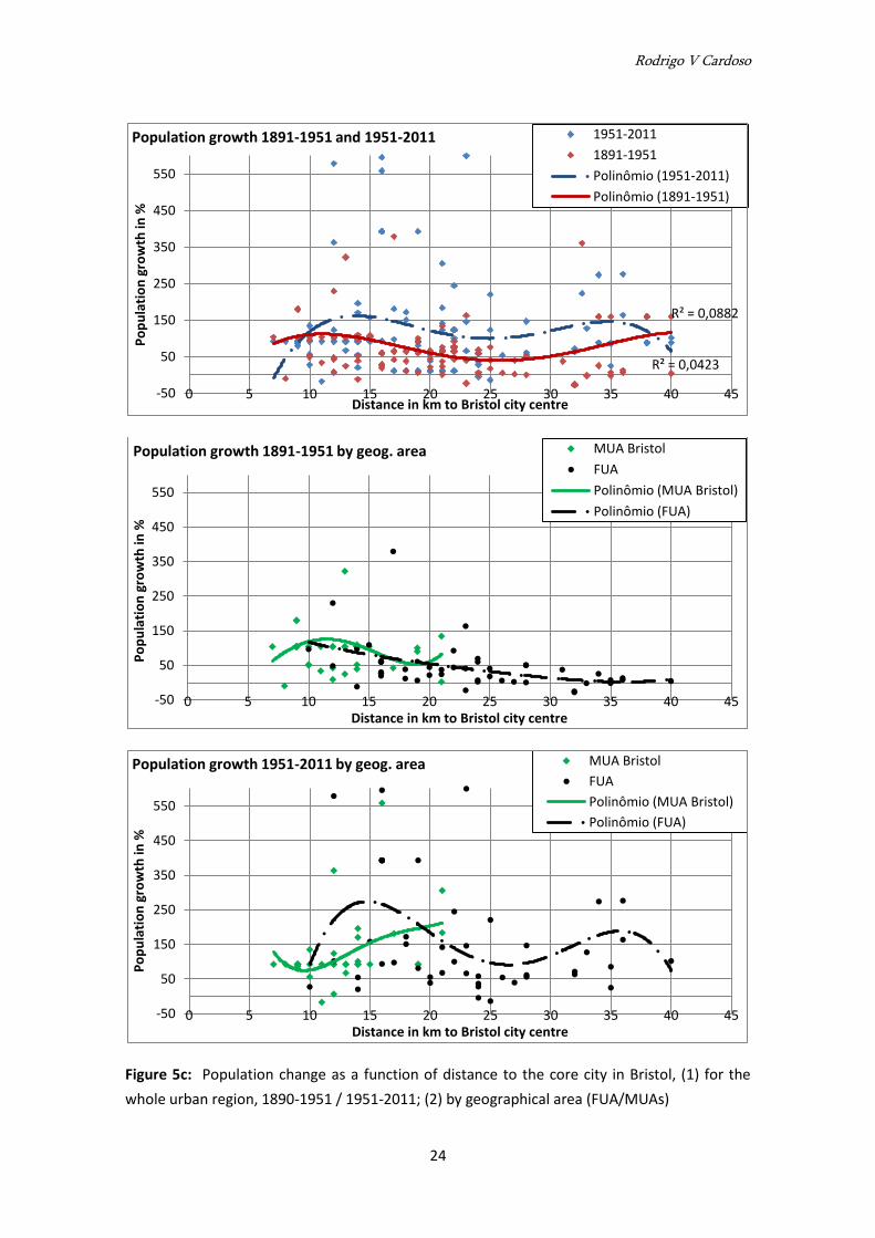
Bristol is a less reliable case, as seen by the lower R2 values, with many equally distant LAU2
units showing disparate values. This is in part due to the continuous administrative boundary
changes in the UK affecting the stability of LAU2 units, but also because of the relatively
compact growth experienced by the individual urban centres (see above) – unlike Porto and
Antwerp, it is possible for a specific LAU2 unit to increase over 500% while the next unit shows
very little growth. In any case, the general trends of Bristol show that between 1891 and 1951
the rate of population change was similar in the whole urban region, with no visible peaks near
the core city. This changed in the 1951-2011 period, with a decrease of growth in the areas
closer to Bristol and an increase around the 15 km distance. The pattern is clearer in the
division by geographical areas, showing how the trend in 1951-2011 in the Bristol MUA reveals
an increase in the rate of population change as the distance to the core city grows, suggesting
a possible ‘leapfrogging’ of development over the Green Belt introduced in the late 1950s. The
FUA regression line peaks around the 15km and rises again in more distant areas, stressing the
importance of alternative sub-centres outside the Bristol core MUA.
Rodrigo V Cardoso
22
Figure 5a: Population change as a function of distance to the core city in Porto: (1) for the
whole urban region, 1890-1951 / 1951-2011; (2) by geographical area (FUA/MUAs)
R² = 0,1716
R² = 0,2256
-50
0
50
100
150
200
250
300
350
400
0 10 20 30 40 50 60
Po
pu
lati
on
gro
wth
in %
Distance in km to Porto city centre
Population growth 1890-1951 and 1951-2011 1951-2011
1891-1951
Polinômio (1951-2011)
Polinômio (1891-1951)
-50
0
50
100
150
200
250
300
350
400
0 10 20 30 40 50 60
Po
pu
lati
on
gro
wth
in %
Distance in km to Porto city centre
Population growth 1890-1951 by geog. area MUA Feira MUA PFerreira MUA Porto FUA Polinômio (MUA Feira) Polinômio (MUA PFerreira) Polinômio (MUA Porto) Polinômio (FUA)
-50
0
50
100
150
200
250
300
350
400
0 10 20 30 40 50 60
Po
pu
lati
on
gro
wth
in %
Distance in km to Porto city centre
Population growth 1950-2011 by geog. area MUA Feira MUA PFerreira MUA Porto FUA Polinômio (MUA Feira) Polinômio (MUA PFerreira) Polinômio (MUA Porto) Polinômio (FUA)
Rodrigo V Cardoso
23
Figure 5b: Population change as a function of distance to the core city in Antwerp: (1) for the
whole urban region, 1890-1951 / 1951-2011; (2) by geographical area (FUA/MUAs)
R² = 0,0217
R² = 0,3832
-50
50
150
250
350
450
550
0 5 10 15 20 25 30 35 40 45
Po
pu
lati
on
gro
wth
in %
Distance in km to Antwerp city centre
Population growth 1890-1947 and 1947-2011 1947-2011
1891-1947
Polinômio (1947-2011)
Polinômio (1891-1947)
R² = 0,4354 R² = 0,1063
-50
50
150
250
350
450
550
0 5 10 15 20 25 30 35 40 45
Po
pu
lati
on
gro
wth
in %
Distance in km to Antwerp city centre
Population growth 1890-1947 by geog. area MUA Antwerp
FUA
Polinômio (MUA Antwerp)
Polinômio (FUA)
R² = 0,1196
R² = 0,2313
-50
50
150
250
350
450
550
0 5 10 15 20 25 30 35 40 45
Po
pu
lati
on
gro
wth
in %
Distance in km to Antwerp city centre
Population growth 1950-2011 by geog. area MUA Antwerp FUA Polinômio (MUA Antwerp) Polinômio (FUA)
Rodrigo V Cardoso
24
Figure 5c: Population change as a function of distance to the core city in Bristol, (1) for the
whole urban region, 1890-1951 / 1951-2011; (2) by geographical area (FUA/MUAs)
R² = 0,0423
R² = 0,0882
-50
50
150
250
350
450
550
0 5 10 15 20 25 30 35 40 45
Po
pu
lati
on
gro
wth
in %
Distance in km to Bristol city centre
Population growth 1891-1951 and 1951-2011 1951-2011
1891-1951
Polinômio (1951-2011)
Polinômio (1891-1951)
-50
50
150
250
350
450
550
0 5 10 15 20 25 30 35 40 45
Po
pu
lati
on
gro
wth
in %
Distance in km to Bristol city centre
Population growth 1891-1951 by geog. area MUA Bristol
FUA
Polinômio (MUA Bristol)
Polinômio (FUA)
-50
50
150
250
350
450
550
0 5 10 15 20 25 30 35 40 45
Po
pu
lati
on
gro
wth
in %
Distance in km to Bristol city centre
Population growth 1951-2011 by geog. area MUA Bristol
FUA
Polinômio (MUA Bristol)
Polinômio (FUA)
Rodrigo V Cardoso
25
4. Discussion and interpretation
Summarising the case studies
This analysis above tried to address questions related to the historical trajectory of
urbanisation in three case studies of European second-tier urban regions. Namely, the analysis
looked for insights about the actual timing, sequence and coexistence of different modes of
urban expansion; and evaluated the role of core cities and other centres to situate the
development mode of these second-tier cities in a ‘region of variability’ somewhere between
the centrifugal expansion mode of dominant primate cities and the fusion mode of equivalent
centres, close to the incorporation mode theorised by Champion (2001).
The strongest feature of the Porto region is the largely autonomous development processes of
its different sub-regions, more erratic and fragmented than Antwerp, where there seemed to
be greater urgency to connect and coalesce into a networked unit. Porto as a core city never
had a strong influence on the region, which suffered forms of dispersion and peri-urbanisation
without having experienced earlier periods of centrifugal expansion and suburbanisation. The
findings above illustrate this: early patterns of polycentric and generalised urbanisation of
territories; simultaneous and continuous population growth in MUAs and FUA regardless of
the dynamics in the core city; strong densification of isolated patches across the region, with
no visible timeline or hierarchy indicating a centrifugal process (even the huge core MUA
growth emerges from the multi-centred dynamics of nine municipalities); and little influence
of core city proximity (and even core MUA) in the general dynamics, with strongly independent
trends going on in individual sub-regions around alternative morphological cores.
This trajectory can be related to two parallel phenomena: first, unlike Lisbon, that tended to
hyper-concentrate economic power and tertiary high-end functions in the core while
decentring housing and lower-order activities to the periphery (Domingues, 2009), Porto
lacked the role of the central state and economic headquarters as producers of centrality,
attractiveness and selective urban functions in the centre. Second, early settlement patterns in
the region were based on very small cadastral divisions, a ‘rhizomatic’ collection of roads and
paths connecting dispersed housing and activities (Portas et al., 2007), and a network of small
urban cores embedded in largely rural lifestyles mixed with small-scale industrialisation, This
generated a progressive densification of the territory with no critical mass or functional
clustering, therefore little demand for new urban functions and little need for long-distance
commuting, as well a weaker perception of a core-periphery contrast.
Rodrigo V Cardoso
26
In Antwerp, the population loss of the core city came with a strong densification of the core
MUA but even more of the FUA. While this could be expected for the dense MUA, as a
consequence of core city centrifugal expansion and relocation of population, the FUA is more
remote and lacks important morphological cores. This suggests that the case of Antwerp has
been more about gradual and dispersed urbanisation brought by the densification of an
existing settlement structure than actual development of a polycentric entity spreading from
established urban cores: like Porto, “the general urbanisation of the territory is to a large
extent a parasite of the pre-existing network of rural roads which undergoes no restructuring
during urbanisation.” (Meulder, 2008: 28). An early and dense coverage of public transport,
small cadastral divisions and a multitude of equally powerful municipalities1 – the latter two
aspects similar to Porto – also played an important role (ibid.). This claim stands even if a
macro view of population change maps shows a more closely knitted urban region than the
Porto case. In Antwerp, the attraction of the core city was indeed greater, but the ‘hotspots’
indicating autonomous and simultaneous growth in several places stress the existence of
alternative, if incipient, urban territories in the region. Their role has gradually gained
importance, as suggested by the different impacts of core city proximity in population change
rates between 1890-1947 and 1947-2011. The gradual flattening of the regression line
suggests less core city dominance over the urban region in recent times.
Porto and Antwerp are clearly the main cores of their region but they have been embedded
very early in an extensive process of dispersed growth that led to a dense and ubiquitous
urban landscape, rather than a truly polycentric region of discrete urban cores. The case of
Bristol is different; the findings suggest that the region was from the beginning the most
polycentric, in the sense that there were several discernible urban cores, but their individual
growth patterns have been more compact than the two other cases. Bristol started from a
similar percentage of ‘urban’ coverage as Porto and Antwerp but the rise of that curve was
much gentler and urbanisation remained relatively self-contained until recently. The result is
an important core city surrounded by smaller urban centres, all with comparatively compact
1 See Harrison and Heley (2015) about how the ‘non-city’ spaces in an urban region actually gather not
only population but also an important part of the region’s decision-making powers and therefore need to be considered at the same level as established cities when envisioning a governance framework for the urban region. In Belgium and Portugal, all municipalities have in theory the same powers over their territory, regardless of their size or urban-rural typology. The British system of single- and double-tier authorities is more complex, especially since the first wave of City Deals gave additional powers to the largest urban local authorities.
Rodrigo V Cardoso
27
development patterns. This is consistent with Barry’s (2000) description of the region since the
seventeenth century as having a strong urban infrastructure in place consisting of numerous
small and medium towns rather than concentration in a single central city. Nevertheless,
Bristol did stand out of the other cities and was dominant in terms of population throughout
the whole study period, even if losing people in certain periods. In fact, that loss2 is the only of
the three cases that has been relatively consistent in time and scale with the growth of the
immediate MUA – thus closer to a classic ‘edge-of-city’ expansion model - mainly due to the
economic success of the north fringe from the 1970s (Boddy el al., 2004). In contrast to the
apparent ‘naturalness’ of the dispersion and densification processes in the other two cases,
based on ancient factors intrinsic to the territory, urban growth in Bristol was more planned,
directed and supported by investment and infrastructure.
Methods and history
An important insight of this analysis responds to the last question raised in the introduction:
despite the traditional neglect of the role of places outside core cities in the processes of
urbanisation, there is more to say about their history than merely seeing them as empty space
awaiting urban expansion. This analysis suggests that ‘non-urban’ territories played indeed an
early role in phenomena of dispersal, polycentricity and extensive urbanisation, often
following a relatively autonomous agenda invisible to urban studies concentrated on core
cities and neglected by models assuming centrifugal urban expansion: in the case of Belgium,
“late nineteenth-century urban dispersal was indeed much more about autonomous
urbanisation within the countryside than about the suburban expansion of established cities.”
(Fisher, 2013: 334). Urbanisation was spread out as much as territories were humanised and
given identity through place names, local networks of activity and people finding their way
through ‘urban’ references, in the sense proposed by Kevin Lynch (1960): rural parish churches
and their bell towers immediately come to mind. In fact, even before the census years
considered here, this was already clear to some observers, as noted by the description of
Northwest Portugal as a ‘continuous city’ of dispersed settlements or Daniel Defoe’s reference
to the Bristol region punctuated by ‘innumerable villages’, both quoted above. Actually, Barry
2 1951-1981 according to the intervals used here, but in fact occurring more strongly between 1971 and
2001, consistent with the suburbanization process in the northern fringe (Boddy et al., 2004) followed by a great increase (380,615 to 432,500) between 2001 and 2011, denoting a return to the centre common to many of the largest English cities.
Rodrigo V Cardoso
28
writes that the South West of England is not usually associated with sudden urban growth in
the main centres in the 19th century (like the Midlands, for example) “in part because of the
strong urban infrastructure already in place, with over a quarter of the region’s people living in
towns by 1660” (2000: 67).
Besides adding local specificity to the generic and travelling models that often underpin
research on extensive urbanisation, these insights speak directly to the recent concerns of
Brenner (2014) or Harrison and Heley (2015) about the city-centric bias of both urban research
and city-regional policy-making: as the role of places outside core cities in the development of
current configurations of urban region is gradually recognised, and all places in the urban
region become more integrated and less differentiated, core-periphery and spatially selective
perspectives must be replaced by the consideration of the full organism of the urban, in which
the ‘city’ is just a rather successful and generalised form. In this sense, an interpretative lens
that recognises this scale as an ‘extensive city’ with urban qualities and problems, supports
integration strategies and sees urban planning as a tool to ensure liveability at any point of the
territory, seems particularly appropriate to deal with this type of urban entity.
The explanation of proto-industrialisation
Interestingly, and regardless of the second-tier city framework underpinning this paper, such
descriptions of fragmented and dispersed urbanisation have been particularly associated to
regions experiencing early (proto-)industrialisation. These regions were supported by a
dispersed network of small industry units inserted into rural typologies that did not tend to
cluster into large complexes or promote the emergence of important functional and
demographic cores. Rather, proto-industrialisation would adapt to and colonise the previous
cadastral and topographic constraints, and, as long as there was sufficient population density,
it was able to recruit the needed workforce from people living nearby who would literally walk
to work3, with no need for major infrastructural, cadastral or functional changes in existing
settlements. As argued by Mendels for eighteenth-century Flanders, “industrial growth was
3 This also relates to the fact that population dispersal throughout the 19
th century is only partially
explained by the effects of the extension of railway. Although a correlation between increasing population densities and the extension of rail (more based on number and proximity of stations than length of lines) has been detected, for example for England and Wales (Felis-Rota et al., 2011), in some cases, like Northwest Portugal, the railway would often follow previous demographic dispersal rather than the other way round.
Rodrigo V Cardoso
29
induced and promoted by population growth. […] The highest levels of rural industrialization
[…] were found in areas with the highest population density and land fragmentation.” (1971:
269). Proto-industrialisation also developed early in South West England, mainly in the form of
heterogeneous and deconcentrated units of cloth industry, “each with specific urban
networks” (Barry, 2000: 81), and Northern Portugal, where the phenomenon of ‘diffuse
industrialisation’ was shown to be characteristic of regions with considerably high population
densities but low rates of urbanisation (Santos, 1992).
This insight – population without proper urbanisation - suggests a hypothetical relation
between the type of core city and the structure of industrialisation in its hinterland. This study
does not go as far back as the emergence of proto-industrialisation, nor does it cover its
multiple explanations or the challenges to the conceptual appropriateness of the notion.
However, Barry (2000) argues that one of the reasons why Bristol, as a city, did not grow as
much as its Northern rivals is that it did not forge hierarchic ties with its industrial hinterland,
consolidating fragmented nodes and promoting (through political power or economic policy)
the emergence of denser and larger complexes in the region. Instead, the city left the
development of the emerging textile industry to its own devices, and concentrated on its main
economic priority, namely being a colonial port city. There was a functional differentiation and
little contact between the workforce in Bristol and the workforce spread across the region.
In this sense, it is interesting to note that Porto and Antwerp were also port cities, largely
relying on related mercantile activities, and have equally failed to consolidate dense industrial
nodes in their surroundings. Arguably, this can also be a case of need and ability to do so. Cities
less concerned with an outward-looking economy and more dedicated to exploit the emergent
economies of its own hinterland would forge stronger ties with this region, promote its
agglomeration economies by upscaling industrial concentration, gradually need to insert
greater infrastructural and functional changes in the pre-existing settlements, attempt to
control decision-making, and ultimately build a more hierarchic political, functional and socio-
economic structure at the urban region scale; this ability probably needs a core city which is,
from the outset, quite large and which gathers an important part of the region’s population
and economic activity. Naturally, this was not the case of our three case studies. Hence the
view by Barry, following his argument about the detachment between Bristol and its industrial
hinterland, that, despite population growth, there was little sign of “a growing Bristol
[demographic] domination of the region.” (Barry, 2000: 79).
Rodrigo V Cardoso
30
This is strikingly similar to the description of ‘dominant’ primate cities, as opposed to ‘weaker’
second-tier cities, as discussed above, namely concerning their need and ability to constrain
the economic, spatial and functional development of the urban region. The question whether
second-tier cities (or perhaps ‘non-primate’ cities), less concerned with and less able to
urbanise and control its surroundings, also tend to be those where the traces of proto-
industrialisation are more visible and those less affected by large-scale consolidation of
industrial nodes provides another path for further research on comparative urban history.
‘The land is a palimpsest’
So what is new? Mainly the scale of the phenomena. Dispersed and fragmented urbanisation
has become less based on small buildings and cadastral divisions and a tight mesh of local
connections to rely more on large infrastructural axes and functional concentrations. While an
increasingly complex functional mix is visible at the urban region scale, specific areas tend to
be more monofunctional at smaller scales (logistics parks, shopping centres, etc.), unlike the
former ‘filigree’ of different activities and land uses in close vicinity. Inevitably, hierarchies
emerge and despite the blurred urban forms, imprecise boundaries and dispersed growth
processes remain, the territory is less isotropic and the fine grain of the ‘urban’ has now
turned coarse and patchy. Additionally, spatially contained lifestyles based on localised
relations and needs now exist alongside greater interdependence at territorial scales.
The relevance of a long-term analysis of the urban region hinges on the fact that these new
and old forms and scales of urbanisation coexist. The ancient, dispersed and loose occupation
of the territory was consolidated, rather than erased, throughout the years and left behind a
porous mesh of urban fragments and mobility networks providing “sufficient infrastructural
support for the post-1960 construction boom.” (Portas el al., 2007: 4). And the less intensive
urbanisation processes detected here, in which the expansive and centrifugal force of core
cities did not play such a dominant role, may have helped to preserve these traces of the past.
There is a contrast between an intensive expansion process, emanating from a strong core and
advancing through large areas of suburban growth, huge functional nodes and massive
infrastructure, with the associated economic and political power providing this ability, and a
trajectory in which the core has less attractive power and critical mass and by consequence
less impact on the development of the urban region. This contrast arguably has an influence
on how much pre-existing configurations were obliterated by metropolitan expansion.
Rodrigo V Cardoso
31
The land is a palimpsest (Corboz, 1983) and the problems emerging from contemporary forms
relate to where they come from and what was there before. How do planning strategies
address the dissociation between large-scale networks (hierarchical and focused on discrete
centres) and existing forms of urbanisation (isotropic and extensive, a continuous fabric rather
than a sequence of nodes)? How do dense functional concentrations ‘land’ onto a sponge-like
territory filled with a capillary fabric? Addressing such questions, informed by the long-term
nature of each urban region, can create the basis for a ‘territorial project’ (Vigano, 2012)
embedded in the concept of the urban region. In Antwerp, the lack of such knowledge was
criticised by Meulder et al. (1999), seeing the 1997 Regional Master Plan for Flanders as an
unfit model borrowed from Dutch experiences, trying to impose a ‘compact city’ policy onto a
“totally contrary” (1999: 80) spatial structure. In Porto, Domingues (2008) has been corrosive
in his critique of the dead ends encountered by generic policy aims, such as urban containment
and polycentricity, when applied to the extensive and non-hierarchic urbanisation patterns of
the urban region. An exercise in specificity and precision can respond to the calls by Sieverts
(1997) and Harrison and Heley (2015) for greater attention of policy and planning to the spaces
in-between ‘proper’ cities where much population actually lives and works.
5. Conclusions
The results help to sustain the claim that there are no ‘pure’ and laboratorial forms of
urbanisation and the route to an urban region shows simultaneous and contradictory features
of expansion, dispersion, consolidation and densification. Bristol evolved from a progressive
expansion of multiple urban nodes, large and small, while Porto and Antwerp followed a more
encompassing and isotropic process of dispersion and densification largely detached from
existing cores. This was more interrelated and directed to integration in Antwerp and more
erratic and autonomous in Porto. In all cases, place-specific factors influenced development
and the modes of urbanisation did not follow a clear sequence or defined chronology.
Dispersed, fragmented and undirected urban processes started early and are in many ways
intrinsic to ancient territorial conditions, rather than based on recent changes such as
suburban lifestyles or the advent of the private car. Coexistence of contradictory trends and
‘leapfrogging’ of stages predicted in generic models are common in all cases. Strong and
continuous core city dominance, either by exerting centripetal and centrifugal forces or
influencing the pace of growth elsewhere through proximity, could not be detected.
Rodrigo V Cardoso
32
Overall, and despite the variability of the trajectories, this situates the three cases within
Champion’s incorporation mode. Porto, Bristol and Antwerp were neither monocentric cities
expanding over a previously unoccupied territory nor part of a set of equivalent centres
gradually fusing as a result of individual expansion and infrastructural linkages. They were the
leading cores of a complex and fragmented region of generalised urbanisation, generating
both alternative centres and scattered urbanised areas lacking a morphological core, which
were relatively self-sufficient and free from core city influence before being incorporated in
the integrated urban region. Future research can explore the veracity of Champion’s corollary
that this allows smaller centres to present a stronger challenge to the main core, in terms of
attracting functions, services and jobs, than the ‘satellites’ emerging from a centrifugal mode.
The last set of observations relates to the specific ability of second-tier cities to generate this
kind of urban region. While the findings here do not claim generalisability of any kind, we have
seen that the common (while nuanced) features of Porto, Antwerp and Bristol stand in direct
opposition to the clear core-periphery contrasts assumed as the ‘original state’ of many
hegemonic, primate cities. Such cities tend to exert a strong influence on their hinterland and
constrain their urbanisation process through centripetal and centrifugal forces; they tend to
evolve from a strong monocentric condition into some form of ‘hierarchical’ polycentricity,
with new centres emerging from the expansion or relocation of core city activity.
The present findings suggest that second-tier cities lacking this ‘big central’ condition (i.e.
lacking a ‘capital effect’, the historical role of the state and the economy as producers of
centrality and attractiveness) have not been able to counteract the tendency for dispersion,
fragmentation and autonomy of urbanisation throughout their hinterland. Population and
activities have not so much ‘decentralised’ but directly emerged in situ and clustered across
the urban region with little respect for boundaries or hierarchies. An immediate consequence
is that the whole territory tends to be filled with infrastructure and thereby receptive to be
repeatedly occupied and consolidated (Meulder, 2008). Despite the costs of such
infrastructural redundancy, if it comes with enhanced accessibility, decentralised urban
functions and a history of cultural identification with local settlements, this may create greater
ability to stay and work in a particular place, thus reducing core-periphery commuting and
generating greater diversity at local scales. Commuting towards the core city is indeed stronger
in Lisbon, London and Brussels than in Porto, Bristol and Antwerp, whose sub-centres tend to
be more self-contained, as recent statistics by the three national offices can show.
Rodrigo V Cardoso
33
A further consequence of such a configuration is that important urban functions tend to be
more distributed throughout the territory, so that the urban region becomes more
interdependent as a whole (Cardoso and Meijers, 2013). Finally, there is a political argument: a
history of horizontal relations, little perception of core city dominance, a sense of widespread
interdependence and weak hierarchies may create a political landscape opposed to the
descriptions of core-periphery assumptions and asymmetric relations around large capitals
(Phelps et al, 2006; Nelles, 2013), as well as mitigating the difficulties to anchor a regional
governance project in polycentric urban regions lacking a leading city (Dieleman and Faludi,
1998; Lambregts, 2006). Future research may be interested in evaluating whether second-tier
cities are indeed cases of such an arrangement somewhere between primate cities and
polycentric urban regions, or rather non-cases failing to recognise this position.
References
Ascher, F. 1995. Métapolis ou l’avenir des villes. Paris: Odile Jacob.
Barry, J. 2000. South-West. In: Clark, P. (ed.) The Cambridge Urban History of Britain – Volume
II 1540-1840. Cambridge: Cambridge University Press, pp. 67-92.
Berg, L. van den et al. 1982. Urban Europe: A Study of Growth and Decline, Vol 1. Oxford:
Pergamon Press.
Boddy, M. et al. 2004. Competitiveness and cohesion in a prosperous city-region: the case of
Bristol. In: Boddy, M. and Parkinson, M. (eds.) City matters. Bristol: Policy Press, pp. 51-70.
Brenner, N. 2014. Implosions/Explosions: Towards a Study of Planetary Urbanization. Berlin:
Jovis Verlag.
Burger, M. J. et al. 2011. Heterogeneous development of metropolitan spatial structure:
evidence from commuting patterns in English and Welsh city-regions. Cities, 28(2), pp. 160-
170.
Cardoso, R. and Meijers, E. 2013. European second-tier cities and the prospects of
metropolisation: the case of Porto. 9th EURS Conference, 10-12 July. University of Sussex,
Brighton.
Champion, A. G. 2001. A Changing Demographic Regime and Evolving Polycentric Urban
Regions: Consequences for the Size, Composition and Distribution of City Populations. Urban
Studies, 38(4), pp. 657-677.
Rodrigo V Cardoso
34
Corboz, A. 1983. The Land as Palimpsest. Diogenes, 31(121), pp. 12-34.
Dieleman, F. and Faludi, A. 1998. Polynucleated metropolitan regions in Northwest Europe:
theme of the special issue. European Planning Studies 6(4), pp. 365-377.
Domingues, A. 2008. Urbanização Extensiva – uma nova escala para o planeamento. CITTA 1st
Annual Conference on Planning Research, May 2008. FEUP, Porto.
Domingues, A. 2009. Como tornar Lisboa uma cidade amigavel, segura e inclusiva para todos?
(ou Adao e Eva no paraiso antes da serpente). Keynote address to the 2nd session of
Seminarios da Carta Estrategica. CCCB, Lisboa.
ESPON. 2007. 1.4.3 - Study on Urban Functions. Final report. Brussels: ESPON and IGEAT.
ESPON. 2012. SGPTD - Second Tier Cities in Territorial Development in Europe: Performance,
Policies and Prospects. Final report. Liverpool: ESPON and European Institute of Urban Affairs.
European Environment Agency (EEA). 2002. Towards an Urban Atlas: Assessment of spatial
data in 25 European cities and urban areas. Copenhagen: European Environment Agency.
Felis-Rota, M., Henneberg, J., Mojica, L. 2011. A GIS Analysis of the Evolution of the Railway
Network and Population Densities in England and Wales 1851-2000. Economic History Society
Annual Conference, 1-3 April, University of Cambridge.
Fisher, A. 2013. Urbanisation sans urbanisme. Une histoire de la 'ville diffuse' (book review).
Planning Perspectives, 28(2), pp. 333-335.
Font, A. (ed.) L’esplosione della città. Bologna: Editrici Compositori
Friedmann, J. 1978. The urban field as human habitat. In: Bourne L. and Simmons J. (eds.)
Systems of Cities: Readings on structure and growth policy. Oxford: Oxford University Press, pp.
42-52.
Gottmann J. 1961. Megalopolis: The Urbanized Northern Seaboard of the United States. New
York: The Twentieth Century Fund.
Grosjean, B.2010. Urbanisation sans Urbanisme: une histoire de la 'ville diffuse. Wavre:
Madraga.
Hall, P. and Pain, K. 2006. The Polycentric Metropolis: Learning from Mega-city regions in
Europe. London: Earthscan.
Harrison, J. and Heley, J. 2015. Governing beyond the metropolis: placing the rural in city-
region development. Urban Studies, 52(6), pp. 1113-1133.
Rodrigo V Cardoso
35
Heynen, H., Loeckx, A. and Smets, M. 1991. La péripherie: reconnaissance d’une
problématique. In: Commission des Communautés européennes, Environnement Urbain-
contribuitions d’experts. Luxembourg: Office des publications officielles des Communautés
européennes, pp. 19-29.
Hohenberg, P. M. 2004. The Historical Geography of European Cities: an Interpretive Essay. In:
Henderson, J. V. and Thisse, J. F. (eds.) Handbook of Regional and Urban Economics, Volume 4.
Amsterdam: Elsevier B.V., pp. 3021-3052
Kasanko M. et al. 2006. Are European cities becoming dispersed? A comparative analysis of 15
European urban areas. Landscape and Urban Planning, 77(1-2), pp. 111-130.
Katz, B. and Bradley, J. 2013. The Metropolitan Revolution: How Cities and Metros Are Fixing
Our Broken Politics and Fragile Economy. Washington D.C.: Brookings Institution Press.
Keil, R. 1994. Going up the country: internationalization and urbanization on Frankfurt's
northern fringe. Environment and Planning D: Society and Space, 12(2), pp. 137-166.
Kipnis, B. A. 2010. Polarization, Spread and Upgrading of Urban Functions: From a Dominating
First City to a Network of Cities Structure. GaWC Research Bulletin 302 [Online]. [Accessed 10
April 2014]. Available from: http://www.lboro.ac.uk/gawc/rb/rb302.html.
Kloosterman, R. and Musterd, S. 2001. The Polycentric Urban Region: Towards a Research
Agenda. Urban Studies, 38(4), pp. 623-633
Lambregts, B. 2006. Polycentrism: Boon or Barrier to Metropolitan Competitiveness? The Case
of the Randstad Holland. Built Environment, 32(2), pp. 114-123.
Lynch, K. 1960. The Image of the City. Cambridge: MIT Press.
McNeill, D. 1999. Globalisation and the European city. Cities, 16(3), pp. 143-147.
Mendels, F. 1971. Industrialization and Population Pressure in Eighteenth-Century Flanders.
The Journal of Economic History, 31(1), pp. 269-271.
Meulder, B. et al. 1999. Patching Up the Belgian Urban Landscape. Oase 52, pp. 78-113.
Meulder, B. 2008. Old Dispersions and Scenes for the Production of Public Space. In: Segal, R.
and Verbakel, E. (eds.) Architectural Design: Cities of Dispersal. New York: Wiley.
Nelles, J. 2013. Cooperation and Capacity? Exploring the Sources and Limits of City-Region
Governance Partnerships. International Journal of Urban and Regional Research, 37(4),
pp. 1349–1367.
Nello, O. 2001. Cataluña, ciudad de ciudades. Lleida: Milenio.
Rodrigo V Cardoso
36
Parr, J. 2004. The Polycentric Urban Region: A Closer Inspection. Regional Studies, 38(3), pp.
231-240.
Phelps, N. et al. 2006. Post-suburban Europe: planning and politics at the margins of Europe’s
capital cities. Basingstoke: Palgrave Macmillan.
Portas, N., Domingues, A. and Cabral, J. 2007. Políticas Urbanas: Tendências, estratégias e
oportunidades. Lisbon: Fundação Calouste Gulbenkian.
Salvati, L. and De Rosa, S. 2014. ‘Hidden Polycentrism' or 'Subtle Dispersion'? Urban growth
and long-term sub-centre dynamics in three Mediterranean cities. Land Use Policy, 39, pp. 233-
243.
Santos, M. 1992. Processos de industrialização difusa: breves notas. Sociologia, 2, pp. 121-144.
Schmid, C. 2006. Networks, Borders, Differences: Towards a Theory of the Urban. In: Diener, R.
et al. Switzerland: an Urban Portrait. Basel: Birkhäuser.
Secchi B. 1989. Un progetto per l'urbanistica. Turin: Einaudi.
Sieverts, T. 1997. Cities without Cities: an interpretation of the Zwischenstadt. London:
Routledge.
Silveira, A. (1789) Racional Discurso sobre a Agricultura e População da Provincia de Alentejo.
In: Nunes, M. and Cardoso, J. L. (eds.) Memórias Económicas da Academia Real das Ciências de
Lisboa 1789-1815, Tomo I. Lisboa: Banco de Portugal, pp. 43-98.
Soja, E. 2000. Postmetropolis: Critical Studies of Cities and Regions. Oxford: Blackwell
Publishing
Soja, E. 2011. Regional Urbanization and the End of the Metropolis Era. In: Bridge, G. and
Watson, S. (eds.) The New Blackwell Companion to the City. Oxford: Blackwell Publishing, pp.
679-689.
Sudjic, D. 1992. The 100 Mile City. San Diego: Harcourt Brace.
Turok, I. and Mikhnenko, V. 2007. The trajectories of European cities, 1960-2005. Cities, 24(3),
pp. 165-182.
Vaughan, L. et al.2009. Do the suburbs exist? Discovering complexity and specificity in
suburban built form. Transactions of the Institute of British Geographers, 34(4), pp. 475-488.
Viganò, P. 2012. The contemporary European urban project: Archipelago city, diffuse city and
reverse City. In: Crysler, C., Cairns, S. and Heynen H. (eds.) The SAGE handbook of architectural
theory. London: SAGE Publications, pp. 657-671.