Embed Size (px)
Citation preview

••
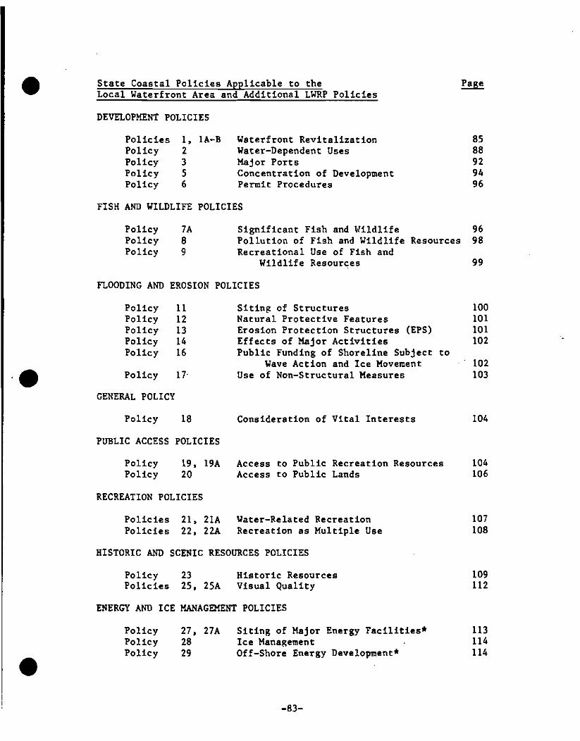
• State Coastal Policies Applicable to the Local Waterfront Area and Additional LWRP Policies
DEVELOPMENT POLICIES
Policies I, 1A-B Waterfront Revitalization 85 Policy 2 Water-Dependent Uses 88 Policy 3 Major Ports 92 Policy 5 Concentration of Development 94 Policy 6 Permit Procedures 96
FISH AND WILDLIFE POLICIES
Policy 7A Significant Fish and Wildlife 96 Policy 8 Pollution of Fish and Wildlife Resources 98 Policy 9 Recreational Use of Fish and
Wildlife Resources 99
FLOODING AND EROSION POLICIES
Policy 11 Siting of Structures 100 Natural Protective Features 101Policy 12
Policy 13 Erosion Protection Structures (EPS) 101 Policy 14 Effects of Major Activities 102 Policy 16 Public Funding of Shoreline Subject to
Wave Action and Ice Movement 102 Policy 17- Use of Non-Structural Measures 103
GENERAL POLICY
Policy 18 Consideration of Vital Interests 104
PUBLIC ACCESS POLICIES
Policy 19, 19A Access to Public Recreation Resources 104 Policy 20 Access to Public Lands 106
RECREATION POLICIES
Policies 21, 21A Water-Related Recreation 107 Policies 22, 22A Recreation as Multiple Use 108
HISTORIC AND SCENIC RESOURCES POLICIES
Policy 23 Historic Resources 109 Policies 25, 25A Visual Quality 112
ENERGY AND ICE MANAGEMENT POLICIES
• Policy 27, 27A Siting of Major Energy Facilities* 113 Policy 28 Ice Manap;ement 114 Policy 29 Off-Shore Energy Development* 114
-83

State Coastal Policies Applicable to the Local Waterfront Area and Additional LWRP Policies
WATER AND AIR RESOURCES POLICIES Page • Policy 30 Water Pollution 115 Policy 31 Water Quality Classifications 115 Policy 33 Stormwater Runoff and Sewer Overflows 116 Policy 34 Vessel Wastes 117 Policy 35 Dredging and Dredge Spoil Disposal 117 Policy 36 Hazardous Wastes Transport and Storage 118 Policy 37 Non-Point Source Water Pollution 118 Policy 38 Surface and Ground Water Protection 120 Policy 39 Solid Wastes Transport and Storage 120 Policy 40 Major Energy and Industrial Facilities 121 Policy 41 Air Quality Standards 121 Policy 42 PSD Land Area Reclassifications* 121 Policy 43 Acid Rain* 121 Policy 44 Wetlands Protection 121
State Coastal Policies Not Applicable to the Local Waterfront Area
The following State Coastal Policies have been determined to be not applicable to the local waterfront area of the City of Ogdensburg:
Policy 4 Small Harbors 93 Policy 7 Significant Fish and Wildlife Habitats
of Statewide Significance 96 Policy 10 Commercial Fishing 100 •Policy 15 Mining, Excavation and Dredging 102 Policy 24 Scenic Resources of Statewide
Significance 112 Policy 26 Agricultural Lands Preservation 113 Policy 32 Alternative Sanitary Waste Systems 116
* Federal agencies should refer to the State Coastal Management Program and Final Environmental Impact Statement or Appendix E of this document for the text of this policy.
• -84

• SECTION THREE
WATERFRONT REVITALIZATION PROGRAM POLICIES
DEVELOPMENT POLICIES:
POLIcY 1
POLIcY lA
•
POLIcY IB
•
RESTORE, REVITALIZE, AND REDEVELOP DETERIORATED AND UNDERUTILIZED WATERFRONT AREAS FOR COMMERCIAL, INDUSTRIAL, CULTURAL, RECREATIONAL AND OTHER COMPATIBLE USES.
RESTORE, REVITALIZE A~~ REDEVELOP CITY-OWNED SITES FOR THE FOLLOWING USES:
a. Former Randall property: public recreational use (shoreline parcel) and sale for commercial or residential development (inland parcel).
b. Shurtleff Block: short term; public recreation space. Long-term; commercial development with consideration given to public recreation space as a multiple use if warranted by demand.
c. East bank of Oswegatchie River from Twin Bridges south to Ogdensburg Dam: continued improvements to public access and recreational facilities such as scenic pathways for jogging, bicycling, walking and fishing access.
d. Lake Street Bridge: streetscape and visual improvements to enhance linkage between riverbanks and recreational opportunities.
e. Ogdensburg Dam and Crescent Street waterworks: redevelopment of the dam for hydroelectric power generation and compatible recreational facilities; adaptive reuse of waterworks building with the dam project if feasible.
PROMOTE THE RESTORATION, REVITALIZATION AND REDEVELOPKE~l OF THE FOLLOWING SITES THROUGH ENCOURAGEMENT AND SUPPORT OF PRIVATE OR JOINT PUBLIC AND PRIVATE SECTOR PROJECTS FOR THE FOLLOWING USES:
a. Former Augsbury Corporation oil tank farm: commercial and/or recreational use with consideration given to public recreational access as a multiple use.
b. West bank of Oswegatchie River bounded by Lake Street, Main Street and the Oswegatchie River: Ogdensburg Dam area; utilities/electric generation use. Shoreline adjacent to dam area north to and including
-85

the Lake Street Bridge; public recreational uae. Remainder of area; mix of commercial and residential u~es. •c. Lighthouse Point: Existing residential uses and public recreational/commercial uses.
d. Mobil Tank Farm: Re-use aa water-dependent industrial use.
Explanation of Policies
All ~overnment agencies must ensure that their actions further the revitalization of the waterfront areas with the City of Ogdensburg. The transfer and purchase of property; the construction of new buildings, roadR or parka; and the provision of tax and other incentives to businesses are examples of governmental means for spurring waterfront revitalization. ~~en any such action, or similar action is proposed, it must be analyzed to determine if the action would contribute to or adversely affect the city's waterfront revitalization efforts. Such efforts' must be recognized as the most effective means of encouraging economic growth in the community, without consuming valuable open space outaide of these waterfront areas. Uses requiring a ·location on the shoreline must be given priority in any development effort. Revitalization efforts muat conform to the other policies of ·this program for the protection and beneficial use of significant coastal resources in Ogdensburg's waterfront.
Ogdensburg's coastal area contains a mix of industrial, commercial •and residential land uses. The list of nine deteriorated and underutilized waterfront areas reflect this diversity. In order to stimulate economic growth in the coastal area, the city will encourage the reinvestment of capital in a broad range of projects with emphaRis on the revitalization and redevelopment of the nine areas cited (aee also Inventory and Analysis, pp. 64-66). The city will promote those projects and activities which support or enhance existing development and revitalization objectives.
The city is committed to promoting the revitalization and beneficial use of these areas in a manner sensitive to other coastal policies including port development (Policy 3); fish and wildlife habitats (Policies 7 through 9); public access and recreation (Polici~s 19 through 23); scenic quality (Policy 25); and water quality (Policies 35 and 36).
When a federal, State or local government action is propos~d to take place in an urban waterfront area regarded aa suitable for development or redevelopment the following guidelines will be used:
a. Priority ahould be given to uses which are dependent on a location adjacent to the water;
• -86
••
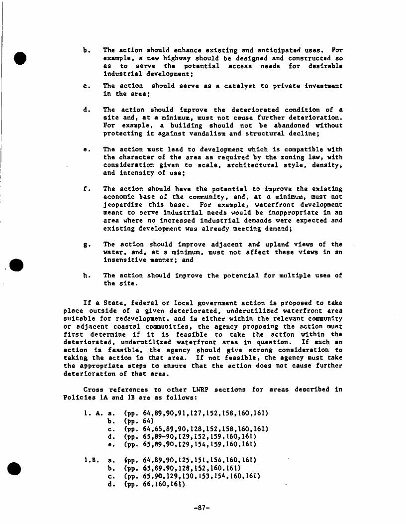
• b. The action should enhance eXisting and anticipated uses. For example. a new highway should be designed and constructed so as to serve the potential access needs for desirable industrial development;
c. The action should serve as a catalyst to private investment in the area;
d. The action should improve the deteriorated condition of a site and. at a minimum, must not cause further deterioration. For example. a building should not be abandoned without protecting it against vandalism and structural decline;
e. The action must lead to development which is compatible with the character of the area as required by the zoning law, with consideration given to scale. architectural style. density. and intensity of use;
f. The action should have the potential to improve the existing economic base of the community. and. at a minimum. must not jeopardize this base. For example. waterfront development meant to serve industrial needs would be inappropriate in an area where no increased industrial demands were expected and existing development was already meeting demand;
g. The action should improve adjacent and upland views of the water. and, at a minimum. must not affect these views in an insensitive manner; and
h. The action should improve the potential for multiple uses of the site.
If a State. federal or local government action is proposed to take place outside of a given deteriorated. underutilized waterfront area suitable for redevelopment. and is either within the relevant community or adjacent coastal communities. the agency proposing the action must first determine if it is feasible to take the actton within the deteriorated. underutilized waterfront area in question. If such an action is feasible. the agency should give strong consideration to taking the action in that area. If not feasible. the agency must take the appropriate steps to ensure that the action does not cause further deterioration of that area.
Cross references to other LIlRP sections for areas described in Policies 1A and 1B are as follows:
1. A. a. (pp. 64.89.90.91.127.152.158.160.161) b. (pp. 64) c. (pp. 64.65,89.90.128.152.158.160.161) d. (pp. 65,89-90.129.152.159.160.161) e. (pp. 65.89.90.129.154.159.160.161)
• 1. B. a • {pp. 64.89.90.125.151.154.160.161) b. (pp. 65.89.90.128.152.160.161) c. (pp. 65.90.129.130.153.154.160.161) d. (pp. 66.160.161)
-87

POLICY 2 - FACILITATE THE SITING OF WATER-DEPENDENT USES AND FACILITIES ON OR ADJACENT TO COASTAL WATERS.
Explanation of Policy • There is a finite amount of waterfront space suitable for
development purposes. Although demand for a specific piece of property will vary with economic and social conditions on both a city-wide and State-vide basis. long-term expectations are for increased demand for waterfront property.
The traditional method of land allocation, i.e •• the real estate market. with or without local land use controls. offers little assurance that uses which require waterfront sites will. in fact. have access to coastal waters. To ensure that such "water-dependent" uses can continue to be accommodated within the city. government agencies will avoid undertaking, funding, or approving non-water-dependent uses when such uses would preempt the reasonably foreseeable development of water-dependent uses; furthermore, government agencies will utilize appropriate existing programs to encourage water-dependent activities.
The following uses and facilities are considered as water-dependent:
1. Uses which depend on the utilization of resources found in coastal waters (for example: fishing);
2. Recreational activities which depend on access to coastal waters (for example: swi=ing, fishing, boating. wildlife viewing) ; • 3. Uses involved in the sea/land transfer of goods (for example: docks. loading areas, pipelines, short- and long-term storage facilities) ;
4. Structures needed for navigational purposes (for example: dams and lighthouses);
5. Flood and erosion protection structures (for example: breakwaters and bulkheads);
6. Facilities needed to store and service boats and ships (for example: marinas. boat repair, boat construction yards);
7. Uses requiring large quantities of water for procassing and cooling purposes (for example: hydroelectric power plants);
8. Scientific/educational activitias which. by their nature. requira access to coastal waters (for example: natural resource nature centers); and
9. Support facilities which are necessary for the successful functioning of permitted water-dependent uses' (for example: parking lots. snack bars. first aid stations, short-term storage •
-811

• facilities}. Though these uses must be near the given water-dependent uses, they should, as much as possible, be sited inland from the water-dependent use rather than on the shore.
In addition to water-dependent uses. uses which are enhanced by a waterfront location should be encouraged to locate along the shore. though not at the expense of water-dependent uses. A water-enhanced use is defined as a use that has no critical dependence on obtaining a waterfront location, but the profitability of the use and/or the enjoyment level of the users would be increased significantly if the use were adjacent to. or had visual access to, the waterfront {e.g•• parks. restaurants. hotels and other tourist accommodations}.
If there is no immediate demand for a water-dependent use in a given area. but a future demand is reasonably foreseeable. temporary non-water-dependent uses would be considered preferable to a non-water-dependent use which involves irreversible, or nearly irreversible commitment of land. Parking lots, passive recreational facilities. outdoor storage areas, and non-permanent structures are uses of facilities which would likely be considered as "temporary," non-water-dependent uses.
• The city will facilitate the location and expansion of
water-dependent uses in its waterfront with particular emphasis on those which will contribute to local revitalization efforts and port. industrial and recreational development. The city has designated the follOWing locations as those best suited for water-dependent or water-enhanced uses:
Port of Ogdensburg: port facilities; water. rail and truck transport.
Former Augsbury Corporation oil tank farm. This parcel is in the process of being sold to new owners under bankruptcy proceedings. Because other parcel's prime waterfront location, strong consideration for water-dependent and. at the least. water-enhanced use{s} should be given. Further study is needed to determine the best use of this parcel.
Randall property shoreline parcel: Recreational use. Inland parcel: water-enhanced use.
East bank of Oswegatchie River. Recreational use.
Ogdensburg Dam. Redevelopment and generation of hydroelectric power.
•
Vest bank of Oswegatchie River. The section adjacent to the Ogdensburg Dam should be reserved for vater-dependent uses. in light of the proposed redevelopment of the dam for hydroelectric power. The riverbank. from the dam area to the Lake Street Bridge including the existing marina. ahould be developed. in concert with the proposed hydroelectric project. for water-dependent recreational uses. The remainder of this area is a mix of commercial and residential uses and is not designated for water-dependent or water-enhanced uses.
-89

Lighthouse Point. Commercial and recreational use(s).
Mobil Tank Farm. The oil tanks have recently been removed and the parcel is for sale. Like the former Augsbury Corporation •oil tank farm, the Mobil tank farm property has a prime waterfront location, and strong consideration for water dependent and, at least, water enhanced use(s) should be given.
Ponderosa Fibres Plant. Industrial use; dependent on water intake and outflow for plant operation.
In the actual chOice of sites where water-dependent uses will be encouraged and facilitated, the following guidelines should be used:
1. Competition for space competition for space or the potential for it, should be indicated before any given site is promoted for water-dependent uses. The intent is to match water-dependent uses with suitable locations and thereby reduce any conflicts between competing uses that might arise. Not just any site suitable for development should be chosen as a water-dependent use area. The choice of a site should be made with some meaningful impact on the real estate market anticipated. The anticipated impact could either be one of increased protection to existing water-dependent activities or else the encouragement of water-dependent development.
2. In-place facilities and services most water-dependent uses, if they are to function effectively, will require basic public facilities and services. In selectinR appropriate areas for water-dependent uses, consideration should be given •to the following factors such as: the availability of public sewer and water services; ability to accommodate parking and necessary storage; and the accessibility of the site via existing streets.
3. Access to navigational channels -- if commercial ahipping or recreational boating are planned, the city should consider setting aside a site, within a sheltered harbor, from which access to adequately sized navigation channels would be assured.
4. Compatibility with adjacent uses and the protection of other coastal resources -- water-dependent uses should be located so that they enhance, or at least do not detract frOl'l, the surrounding community. Consideration should also be given. to such factors as the protection of nearby residential areas from odore, noise and traffic. Affirmative approaches should also be employed so that water-dependent uses and adjacent uses can serve to complement one another. For example. a recreation-oriented water-dependent use area could be sited in an area already oriented towards tourism. Clearly, a marina, fishing pier or swimming area would enhance, and in turn be enhanced by, nearby restaurants, motels and other non-water-oriented touriAts activities. Water-dependent uses •

• must also be sited so as to avoid adverse impacts on the significant coastal resources.
5. Preference to underutilized sites the promotion of water-dependent uses should serve to foster development as a result of the capital programming, permit expediting, and other State and local actions that will be used to promote the site. Nowhere is such a stimulus needed more than in those portione of the city's waterfront areas which are currently underutilized.
6. Providing for expansion a primary objective of the policy is to create a process by which water-dependent uses can be accommodated well into the future. State agencies and the city should therefore give consideration to long-'term space needs and, where practicable, accommodate future demand by identifying more land than is needed in the near future.
In promoting water-dependent uses, the following kinds of actions should be considered:
• Favored treatment to water-dependent use areas with respect to capital programming. Particular priority should be given to .the construction and maintenance of port facilities, roads, railroad facilities, parking areas, and storage areas suitable for water-dependent uses.
When areas suitable for water-dependent uses are publicly owned, favored leasing arrangements should be given to waterdependent uses.
Where possible, consideration should be given to providing water-dependent uses with property tax abatements, loan guarantees, or loans at or below maTket rates.
State and city planning and economic development agencies should actively promote water-dependent uses. In addition, a list of sites available for non-water-dependent uses should be maintained in order to assist developers seeking alternative sites for their proposed projects.
Local, State and federal agencies should work together to stTeamline permitting pToceduTes that may be bUTdeusome to water-dependent uses: This effort should begin for specific uses in deteTioTated and undeTutilized areas.
• Local land use controls should be consideTed as a tool of local government for assuring adequate space for the development of water-dependent uses and the protection of sensitive areas •
-91

POLICY 3 - FURTHER DEVELOP THE STATE'S KAJOR PORTS OF ALBANY, BUFFALO, NEW YORK, OGDENSBURG AND OSWEGO AS CENTERS OF COMMERCE AND INDUSTRY, AND ENCOURAGE THE SITING IN THESE PORT AREAS INCLUDING THOSE UNDER •THE JURISDICTION OF STATE PUBLIC AUTHORITIES, OF LAND USE AND DEVELOPMENT WHICH IS ESSENTIAL TO, OR IN SUllPORT OF, THE WATERBORNE TRANSPORTATION OF CARGO AND PEOPLE.
Explanation of Policy
The Port of Ogdensburg is designated as one of five major ports in New York State. As such, it is a vital component of not only the City's but the State's economic well being. The aim of this policy is to support port development and activities in the City of Ogdensburg.
Three other development policies, discussed in this Section, also have significant implications for port development, namely: water dependency (Policy 2); concentration of development (Policy 5); and the expediting of permit reviews (Policy 6). In implementing this policy, State, federal and local agencies will recognize that jurisdiction of this policy extends over the Ogdensburg Bridge and Port Authority (OBPA) marine terminal facilities as illustrated on Plate 5, as well as any future expansions or improvements to such facilities. If an action is proposed for a site within or abutting the port, or if there is a reasonable expectation that a proposed action elsewhere would have ap impact on the port, then the following guidelines shall be used ~ in determining consistency:
In assessing proposed projects within or abutting the port, given that all other applicable policies are adhered to, consideration shall be given to the maintenance and enhancement of port activity, l.e. development related to waterborne transportation.
2. Dredging to maintain the economic viability of the port will be regarded as an action of regional or statewide public benefit if: a clear need is shown for maintaining or improving the established alignment, width, and depth of eXisting channels or for new channels essential to port activity; and, it can be demonstrated that environmental impacts would be at acceptable levels according to State regulations governing the activity.
3. Landfill projects in the nearshore areas will be regarded as an acceptable activity within major port areas, provided adverse environmental impacts are acceptable under all applicable environmental regulation and a strong economic justification is demonstrated.
4. If non-port related activities are proposed to be located in or near to the port, these uses shall be sited so as not to interfere with normal port operations. •
-92

• 5 • When not already restricted by existing laws or covenants, and when there is no other overriding regional or statewide public benefit for doing otherwise, surplus public land or facilities within or
•
adjacent to the port shall be offered for sale, in the first instance, to the Port Authority.
6. In the programming of capital projects for the port area, highest priority will be given to projects that promote the development and use of the port. However, in determining such priorities, consideration must also be given to non-port related interests within or near the port that have demonstrated critical capital programming needs.
7. No buildings, piers, wharves, or vessels shall be abandoned or otherwise left unused by a public agency or sold without making provisions for their maintenance in sound condition or for their demolition or removal.
8. Proposals for the development of new major ports will be assessed in terms of the anticipated impact on: a) existing New York State major ports including Ogdensburg; b) existing modes of transportation; and c) the surrounding land uses and overall neighborhood character of the area in which the proposed port is to be located; d) and other valued coastal resources.
9. Port development shall provide opportunities for public access insofar as these opportunities do not interfere with the day-to-day operations of the port and the Port Authority and its tenants do not incur unreasonable costs.
The Ogdensburg Port Master Plan and Development Study (1984) sets forth a ten-year, three-phase development program for the Port of Ogdensburg. Phase one of this plan is now underway (see pages 29-32 and 41-47). Future development and improvements at the port shall be in accordance with this Master Plan. The City of Ogdensburg shall work with the Port Authority in furthering port development plans and activities and, given that all other applicable policies are adhered to, will give top consideration to such development; The Port Authority shall, in turn, abide by all applicable coastal policies in carrying out port development programs and activities. The constraints of intra-city port transportation routes will be considered in any future Port of Ogdensburg development. The Port Authority and the city shall continue to maintain open communication and cooperation
• on port-related plans and pro~ects •
POLICY 4 - NOT APPLICABLE
-93

POLICY 5 - ENCOURAGE THE LOCATION OF DEVELOPMENT IN AREAS WHERE PUBLIC SERVICES AND FACILITIES ESSENTIAL TO SUCH DEVELOPMENT ARE ADEQUATE, EXCEPT WHEN SUCH DEVELOPMENT HAS SPECIAL FUNCTIONAL REQUIREMENTS OR • OTHER CHARACTERISTICS WHICH NECESSITATES ITS LOCATION IN OTHER COASTAL AREAS.
Explanation of Policy
Through governmental actions, development in the waterfront area will be encouraged to locate within or in close proximity to existing areas of concentrated development where infrastructure and public services are adequate, where topography, geology, and other environmental conditions are suitable for and able to accommodate development.
This policy is intend~d to accomplish the following:
strengthen existing residential, industrial, and commercial centers;
foster an orderly pattern of growth;
increase the efficiency of existing public services and moderate the need to provide new public services in outlying areas;
preserve open space in sufficient amounts; and
where desirable, foster energy conservation by •encouraging proximity between home, work and leisure activities.
In assessing the adequacy of an area's infrastructure and public services, the following points shall be considered:
a. Streets and highways serving the proposed site can safely accommodate the peak traffic generated by the proposed land development;
b. Development's water needs (consumptive and fire fighting) can be met by the existing water supply system;
c. Sewage disposal system can accommodate the wastes generated by the development;
d. Energy needs of the proposed land development can be accommodated by existing utility systems;
e. Stormwater runoff from the proposed site can be accommodated by on-site end/or off-site facilities; and
f. Schools, police and fire protection, and health and social services are adequate to meet the needs of the population expected to live, york, shop, or conduct business in the area as a result of the development. •
-94

• It is recognized that certain forms of development may and/or
should occur at locations which are not within or near areas of concentrated development. Thus, this coastal development policy does not apply to the following types of development projects and activities:
1. Economic activities which depend upon sites at or near locations where natural resources are present, e.g., lumber industry, quarries.
2. Development which by its nature is enhanced by a non-urbanized setting, e.g., a resort complex, campgrounds, second home development.
3. Development which is designed to be a self-contained activity, e.g., a small college, an academic or religious t'ett'eat~
4. Water-dependent uses with site requirements not compatible with this policy or when alternative sites are not available.
5. Development which because of its isolated location and small-scale has little or no potential to generate and/or encourage further land development.
• 6. Uses and/or activities which because of public safety
consideration should be located away from populous areas •
7. Rehabilitation or restoration of existing structures and facilities.
8. Development projects which are essential to the construction and/or operation of the above uses and activities.
In certain areas where development is encouraged by these policies, the condition of existing public water and sewage infrastructure and other services may necessitate improvements. Those State and federal agencies charged with allocating funds for investments in public services and water and sewer facilities should give high priority to the needs of such areas so that full advantage may be taken of the rich array of their other infrastructure components in promoting waterfront revitalization.
•
Water, sewer and power are adequate for most foreseeable development in the Ogdensburg cosstsl sres (see pp. 54-56). Vehicular and pedestrian access and parking facilities for future development, in particular for those areas cited in Policies I, 2, and 3, will be assessed on a case-by-case basis in accordance with Ogdensburg site development plan specifications (Article IV, section 30.44). Future Port of Ogdensburg development will consider constraints on increased traffic flow on port transportation routes •
-95

POLICY 6 - EXPEDITE PERMIT pROCEDURES IN ORDER TO FACILITATE THE SITING OF DEVELOPMENT ACTIVITIES AT SUITABLE LOCATIONS. •
Explanation of Poltcy
For specific types of development activities and in areas suitable for such development, the city will make every reasonable effort to coordinate and expedite local permit procedures and regulatory activities as long as the integrity of the regulatory objectives is not jeopardized. Nevertheless. the city's efforts in expediting permit procedures are part of a much larger system for regulating development, which also includes county, State and federal government agencies. Regulatory programs and procedures should be coordinated and synchronized between all levels of government snd, if necessary. legislative progra1l1l!latic changes will be recommended from the local level.
FISH AND WILDLIFE POLICIES
POLICY 7 - NOT APPLICABLE
POLICY 7A - THE ST. LAWRENCE AND OSlfEGATCHIE RIVERS AND TIBBITS CREEK CONTAIN LOCALLY SIGNIFICANT FISH AND WILDLIFE HABITATS (see Plates 3a &b). THESE AREAS WILL BE PROTECTED AND PRESERVED TO MAINTAIN THEIR VIABILITY AND VALUE TO THE CITY.
Explanation of Policy •Habitat protection is recognized as fundamental to assuring
the survival of the fish and Wildlife populations. Certain habitats are particularly critical to the maintenance of a given population and therefore merit special protection. Such habitats exhibit one or more of the following characteristics: (1) are essential to the survival of a large portion of a particular fish or wildlife population (e.g. feeding grounds, nursery areas); (2) support populations of rare and endangered species; (3) are found at very low frequency within a coastal region; (4) support fish and wildlife populations having significant commercial or recreational value; and (5) would be difficult or impossible to replace. The St. Lawrence and Oswegatchie Rivers, as well as Tibbits Creek meet the fourth and fifth criteria (refer to Inventory and Analysis, pp. 15-19) and therefore merit special protection.
The NYS Department of EnVironmental Conservation has indicated that no fish and wildlife habitats of statewide significance exist in the coastal area. However the Oswegatchie and St. Lawrence Rivers and Tibbits Creek contain locally significant fish and wildlife habitats. The large diversity of fish species in these vater bodies prOVide an important recreational fishery (see pp. 15-19. Plates 3a & b. and Appendix ~. •
-96

• In order to protect these habitats, development shall not be
undertaken if it may destroy or significantly impair the viability of these areas as a habitat. Particular care must be taken during the critical spawning period of Karch 15th - July 15th in those spawning sreas cited on pages 15-19. Indicators of a significantly impaired habitat include: reduced carrying capacity, changes in food chain relationships of species diversity, reduced productivity, and/or increased incidence of disease and mortality.
The range of activities most likely to affect these significant fish and wildlife habitats includes but is not limited to the following:
1. Draining wetlands, ponds: Causes changes in vegetation, or changes in groundwater and surface water hydrology.
2. Filling wetlands, shallow areas of streams, lakes, bays, estuaries: Kay change physical character of substrate (e.g., sandy to muddy, or smother vegetation, alter surface water hydrology).
3. Grading land: Results in vegetation removal, increased surface runoff, or increased soil erosion and downstream sed imenta t ion.
• 4. Clear cutting: Kay cause loss of vegetative cover,
increase fluctuations in amount of surface runoff, or increase streambed scouring, soil erosion, aediment deposition.
5. Dredging or excavation: May cause change in substrate composition, possible release of contaminants otherwise stored in sediments, removal of aquatic vegetation, or change circulation patterns and sediment transport mechanism.
6. Dredge spoil disposal: Kay include shoaling of littoral areas, or change circulation patterns.
7. Physical alteration of shore areas through channelization or construction of shore structures: Kay change volume and rate of flow or increased scouring, sedimentation.
8. Introduction, storage or disposal of pollutants such as chemical, petrochemical, solid wastes, nuclear wastes, toxic material, pesticide, sewage effluent, urban and rural runoff, leachate or hazardous and toxic substances stored in landfills: May cause increased mortality or sublethal effects on organisms, alter their reproductive capabilities, or reduce their value a food organisms.
• 9 • Introduction of new species or large quantities of any species: Kay change the established balance within the biota.
-97

The range of physical, biological and chemical parameters which should be considered include but are not limited to the following:
Physical parameters such as: Living space, circulation, flushing rates, tidal amplitude, turbidity, water temperature, depth (loss of littoral zone), morphology, substrate type, vegetation, structure, erosion and sedimentation rates.
Biological parameters such as: Community structure, food chain relationships, species diversity, predator/prey relationships, population size, mortality rates, reproductive rates. behavioral patterns, and migratory patterns.
Chemical parameters such as: Dissolved oxygen, carbon dioxide, Ph, dissolved solids, nutrients, organics, salinity, pollutants (heavy metals, toxic and hazardoua materials) •
When a proposed action is likely to alter any of the biological, physical or chemical parameters as described in the narrative beyond the tolerance range of the organisms occupying the habitat, the viability of that habitat has been significantly impaired or destroyed. Such action, therefore, would be inconsistent with the above policy.
POLICY 8 PROTECT FISH kVD WILDLIFE RESOURCES IN THE COASTAL AREA FROM THE INTRODUCTION OF HAZARDOUS WASTES AND OTHER POLLUTANTS WHICH BIO-ACCUMULATE IN THE FOOD CHAIN OR WHICH CAUSE SIGNIFICANT SUBLETHAL OR LETHAL EFFECTS ON THOSE RESOURCES.
Explanation of Policy
Hazardous wastes are unwanted byproducts of manufacturing processes generally characterized as being flammable, corrosive, reactive, or toxic. More specifically, hazardous waste is defined in Environmental Conservation Law § 27-0901.3 as follows: "Hazardous waste means a waste or combination of wastes which because of its quantity, concentration, or physical, chemical or infectious characteristics may: (I) cause, or aignificantly contribute to an increase in mortality or an increase in serious irreversible illness; or (2) post' a substantial present or potential hazard to human health or the environmant when improperly treated, atored, transported or otherwise managed." A list of hazardous wastes has been adopted by DEC (6 NYCRR Part 371) •
The handling (storage, transport, treatment and dispoaal) of the materials included on this list is being strictly regulated in New York State to prevent their entry or introduction into the
-98
•
•
~

• environment. Such controls should effectively minimize possible contamination of and bioaccumulation in the State's coastal fish and wildlife resources at levels that cause mortality or create physiological and behavioral disorders.
•
•
Other pollutants are those conventional wastes, generated from point and non-point sources, and not identified as hazardous wastes but controlled through other State laws.
POLICY 9 - EXPAND RECREATIONAL USE OF FISH AND WILDLIFE RESOURCES IN COASTAL AREAS BY INCREASING ACCESS TO EXISTING RESOURCES, SUPPLEMENTING EXISTING STOCKS AND DEVELOPING NEW RESOURCES. SUCH EFFORTS SHALL BE MADE IN A MANNER WHICH ENSURES THE PROTECTION OF RENEWABLE FISH AND WILDLIFE RESOURCES AND CONSIDERS OTHER ACTIVITIES DEPENDENT ON THEM.
Explanation of Policy
Recreational uses of coastal fish and wildlife resources include consumptive uses such as fishing and hunting, and nonconsumptive uses such as wildUfe photography, bird watching and nature study.
Any efforts to increase recreational use of these resources will be made in a manner which ensures the protection of fish and wildUfe resources and activities dependent upon them (fishing, charterboat operations, bird watching) which are important to the local economy. Such efforts should be made in accordance with existing State law and sound resource management considerations. Management considerations include biology of the species, carrying capacity of the resource, public demand, costs and available technology.
Limited fishing access to the Oswegatchie River is currently available along the river banks between the Lake Street Bridge and the dam and at the dam site. Improvements to the east and west bank of the Oswegatchie will facilitate fishing access to the river and improve public safety at these sites (east bank pp. 64, 65, 89, 90, 128, 152, 158, 160, 161; west bank pp.65, 89, 128, 152, 160, 161). Access to the St. Lawrence River is available in the Greenbelt Park area with improvements proposed for the Randall property (see pp. 64, 89, 90, 91, 127, 152, 160, 161).
The following additional guidelines should be considered by all government agencies as they determine the consistency of their proposed actions with this policy:
1. Consideration should be made by federal, State and local agencies as to whether an action will impede existing or future utilization of the recreational fish and wildlife resources in the vicinity of the city or accessible from its harbor or other access sites •
-99

2. Efforts to increase aCcess to recreational fish and wildlife resources should not lead to overutilization of that resource or cause impairment of the habitat. Sometimes such impairment can be more subtle than actual • physical damage to the habitat. For example, increase human presence can deter animals from using the area.
3. The impacts of increasing access to recreational fish and wildlife resources should be determined on a case-by-case basis, consulting with the significant habitat narrative (see Policy 7) and/or conferring with a trained fish and wildlife biologist.
4. Any public or private sector initiatives to supplement existing stocks (e.g., stocking a stream with fish reared in a hatchery) or develop new resources (e.g., creating private fee-hunting or fee-fishing facilities) must be done in accord with existing State law.
POLICY 10 - NOT APPLICABLE
FLOODING AND EROSION HAZARDS POLICIES
POLICY 11 - BUILDINGS AND OTHER STRUCTURES WILL BE SITED IN THE COASTAL AREA SO AS TO MINIMIZE DAMAGE TO PBOPERn AND THE ENDANGERING OF HUMAN LIVES CAUSED BY FLOODING AND EROSION.
Explanation of Policy • Flooding: Areas of special flood hazard have been identified
and mapped in Ogdensburg by the Federal Insurance Administration. Development in the city is subject to flood damage regulations through Article VIII of the city Municipal Code which contains standards to meet the requirements of the National Flood Insurance Program.
Erosion: Although upland erosion is not a significant problem in the city. coastal erosion along the St. Lawrence River is cause for concern. Areaa particularly subject to erosion include the shoreline east of the port terminal and on Chimney Point (see Plates 12a and 12b).
Coastal erosion is being addressed by the State Coastal Erosion Hazard Act (CERA) which sets up a development pemit system and requires DEC to map all coastal erosion hazard areas. Mapping has not yet been initiated by DEC. When DEC cOlIpletes this mapping, if such coatal erosion hazard areas are found. the city will review the local program at that time and comply with or supplenent policies and regulationa as needed. In the interim,
•

• erosion problems will be considered in the evaluation of actions proposed for areas of locally important erosion (see Plates 12a and b).
Also, some cause for concern is the damage caused by ice movement and wind-driven wave action in exposed coastal areas. When resistance to these forces is a factor in the design, construction and maintenance of shoreline structures, their durability will be increased and utility prolonged.
POLICY 12 ACTIVITIES OR DEVELOPMENT IN THE COASTAL AREA WILL BE UNDERTAKEN SO AS TO MINIMIZE DAMAGE TO NATURAL RESOURCES AND PROPERTY FROM FLOODING AND EROSION BY PROTECTING NATURAL PROTECTIVE FEATURES INCLUDING BEACHES. DUNES, BARRIER ISLANDS A~~ BLUFFS. PRIMARY DUNES WILL BE PROTECTED FROM ALL ENCROACHMENTS THAT COULD IMPAIR THEIR NATURAL PROTECTIVE CAPACITY.
Explanation of Policy
•
Beaches. dunes. barrier islands. bluffs. and other natural protective features help safeguard coastal lands and property from damage, as well as reduce the danger to human life, resulting from flooding and erosion. Excavation of coastal features. improperly designed structures. inadequate site planning. or other similar actions which fail to recognize their fragile nature and high protective values. lead to. the weakening or destruction of those landforms. Activities or development in. or in proximity to • natural protective features must ensure that all such adverse effects are minimized. Primary dunes will be protected from all encroachments that could impair their natural protective capacity. Ogdensburg's natural protective features are in the form of small bluffs and are associated with those areas identified on Plates l2a and b as being subject to erosion.
POLICY 13 - THE CONSTRUCTION OR RECONSTRUCTION OF EROSION PROTECTION STRUCTURES SHALL BE UNDERTAKEN ONLY IF THEY HAVE A REASONABLE PROBABILITY OF CONTROLLING EROSION FOR AT LEAST THIRTY YEARS AS DEMONSTRATED IN DESIGN AND CONSTRUCTION STANDARDS AND/OR ASSURED MAINTENANCE OR REPLACEMENT PROGRAMS.
Explanation of Policy
Erosion protection structures such as bulkheads and riprap are used at the OBPA marine facilities. the grain elevator (bulkhead), the city's Greenbelt Park and marina, and along portions of the east and west banks of the Oswegatchie River. Someti~es. because of improper design. construction. or maintenance standards. such structures fail to give the protection which they are presumed to prOVide. As a result, development is aited in areas where it is subj ect to damage or loss due to
• erosion. This policy will help ensure the reduction of such da1llllge or 10s9 •
-101

••
POLICY 14 - ACTIVITIES AND DEVELOPMENT INCLUDING THE CONSTRUCTION OR RECONSTRUCTION OF EROSION PROTECTION STRUCTURES. SHALL BE UNDERTAKEN SO THAT THERE WILL •BE NO MEASURABLE INCREASE IN EROSION OR FLOODING AT THE SITE OF SUCH ACTIVITIES OR DEVELOPMENT. OR AT OTHER LOCATIONS.
Explanation of Policy
Though flooding and erosion occur naturally, hll1llan actions can increase the severity and adverse effects of these processes. causing property loss or damage and endangering lives. Actions which tend to increase flooding and erosion include the use of impermeable erosion protection structures such as groins or solid docks which block the littoral transport of sediment to adjacent shore lands. Such structures increase the rate of shoreline recession. Also, the failure to observe proper drainage or land restoration practices causes runoff and erosion or weakening of shorelands. Areas subject to erosion in the Ogdensburg coastal area are shown on Plates 12a and b. Reconstruction of existing erosion protection structures (see Policy 13) and new erosion protection structures shall not Cause an increase in erosion or flooding. Erosion control practices cited in Policy 37 shall also be utilized in the implementation of this policy.
Flood control policy for development is covered under Policy 11.
POLICY 15 - NOT APPLICABLE
POLICY 16 - PUBLIC FUNDS SHALL ONLY BE USED FOR EROSION PROTECTIVE STRUCTURES WHERE NECESSARY TO PROTECT HUMAN LIFE. ANll NEW DEVELOPMENT WHICH REQUIRES A LOCATION WITHIN OR ADJACENT TO AN EROSION HAZARD AREA TO BE ABLE TO FUNCTION, OR EXISTING DEVELOPMENT; AND ONLY WHERE TIlE PUBLIC BENEFITS OU1WEICH THE LONG TERM MONETARY AND OTIlER COSTS INCLUDING TIlE POTENTIAL FOR INCREASINC EROSION AN1l ADVERSE EFFECTS ON NATURAL PROTECTIVE FEATURES.
Explanation of Policy
Public funds are used for a ...ariety of purposes on the State's shorelines. This policy recognizes the public need for protection of human life and in...estments in existing or propoeed developments which require a waterside location to be able to function. However, it also recognizes the adverse impacts of such
• -102

• activities and developments on the rate of erosion and on natural protective features. The policy requires careful analysis to be made of the benefits and long-term costs prior to expending public funds.
•
•
POLICY 17 - WHENEVER POSSIBLE, USE NONSTRUCTURAL MEASURES TO MINIMIZE DAMAGE TO NATURAL RESOURCES AND PROPERTY FROM FLOODING AND EROSION. SUCH MEASURES SHALL INCLUDE:
(i) THE SET BACK OF BUILDINGS AND STRUCTURES; (H) THE PLANTING OF VEGETATION AND THE
INSTALLATION OF SAND FENCING AND DRAINING: (Hi) THE RESHAPING OF BLUFFS; AND (iv) THE FLOOD PROOFING OF BUILDINGS OR THEIR
ELEVATION ABOVE THE BASE FLOOD LEVEL.
Explanation of Policy
This policy recognizes both the potential adverse impacts of flooding and erosion upon development and upon natural protective features in the coastal area as the costs of protection against those hazards which structural measures entail.
Nonstructural measures shall include, but not be limited to:
1. Within coastal erosion hazard areas identified under Section 34-104, Coastal Erosion Hazard Areas Act (Article 34. Environmental Conservation Law)" and subject to the permit requirements on all regulated activities and development established under that law: (a) the use of minimum setbacks as provided for in Section 34-108; and (b) the strengthening of coastal land-forms by the planting of appropriate vegetation, the reshaping of bluffs to achieve an appropriate angle. of repose and the installation of drainage systems on bluffs to reduce runoff and internal seepage of waters which erode or weaken the landforms; and
2. Within identified flood hazard areas, (a) the siting of buildings outside the hazard area, and (b) the flood-proofing of buildings.
This policy shall apply to the planning, siting and design of proposed activities and development, including measures to protect existing activities and development. To ascertain consistency with the policy, it must be determined if anyone, or a combination of, nonstructural measures would afford the degree of protection appropriate both to the character and purpose of the activity or development, and to the hazard. If nonstructural measures are determined to offer sufficient protection, then consistency with the policy would require the use of such measures, whenever possible •
-10~-

In determining whether or not nonstructural measures to protect against erosion or flooding will afford the degree of protection appropriate, an analysis, and if necessary, other materials such as plans or sketches of the activity or development, of the site and of the alternative protection measures should be prepared, to allow an assessment to be made.
GENERAL POLICY
POLICY 18 TO SAFEGUARD THE VITAL ECONOMIC, SOCIAL AND ENVIRONMENTAL INTERESTS OF THE STATE AND OF ITS CITIZENS, PROPOSED MAJOR ACTIONS IN THE COASTAL AREA MUST GIVE FULL CONSIDERATION TO THOSE INTERESTS, AND TO THE SAFEGUARDS WHICH THE STATE HAS ESTABLISHED TO PROTECT VALUABLE COASTAL RESOURCE AREAS.
Explanation of Policy
Proposed major actions may be undertaken in the coastal area if they will not significantly impair valuable coastal waters and resources, thus frustrating the achievement of the purposes of the safeguards which the State and city have established to protect those waters and resources. Proposed actions must take into account the social, economic and environmental interests of the State, the city and their citizens in such matters that could affect natural resources, water levels and flows, shoreline damage, hydroelectric power generation and recreation.
PUBLIC ACCESS POLICIES
POLICY 19 PROTECT, MAINTAIN AND INCREASE THE LEVELS AND TYPES OF ACCESS TO PUBLIC WATER-RELATED RECREATION RESOURCES AND FACILITIES SO THAT THESE RESOURCES AND FACILITIES MAY BE FULLY UTILIZED BY ALL THE PUBLIC IN ACCORDANCE WITH REASONABLY ANTICIPATED PUBLIC RECREATION NEEDS AND THE PROTECTION OF HISTORIC AND NATURAL RESOURCES. IN PROVIDING SUCH ACCESS, PRIORITY SHALL BE GIVEN TO PUBLIC BEACHES, BOATING FACILITIES, FISHING AREAS, AND WATERFRONT PARKS.
POLICY 19A - PROTECT, MAINTAIN AND IMPROVE PEDESTRIAN, VEHICULAR AND WATERBORNE ACCESS TO PUBLIC WATER-RELATED RECREATIONAL FACILITIES ALONG THE ST. LAWRENCE AND OSWEGATCHIE RIVERS.
Explanation of Policies
This policy calls for achieving balance among the following factors: the level of access to a resource or facility, the capacity of a resource or facility, and the protection of natural resources. Because an imbalance among these factors is often due to access-related problems, priority will be given to improving physical access to existing and potential coastal recreation sites. The Local Waterfront Revitalization Program viII encourage mixed use areas and multiple use of facilities to improve aCCess.
-104
•
•
•

• The particular water-related recreation resources and
facilities which will receive priority for improved access in Ogdensburg are fishing areas, boating facilities, access roads and passive/active recreational park areas. To optimize the use of these resources, the city must facilitate various modes of access, including pedestrian, vehicular and waterborne with consideration given to handling short term peaks in demand for parking during major events.
In Ogdensburg, this policy will be implemented through continued maintenance of the riverfront Greenbelt Park, Library Park, and the city beach, and through improvements in public access to the recreational opportunities on the east bank of the Oswegatchie River. Current levels of public access to the St. Lawrence Psychiatric Center will not be constrained without due cause. Public access to current and future recreational and scenic opportunities at Commerce Park and Lighthouse Point will be provided (see Inventory and Analysis, pp. 34-36). In addition, support will be given to both public and private measures taken to expand dockage and related facilities to improve accessibility of boaters to the St. Lawrence River. Potential areas of expansion for this purpose will be studied to assess the demand and location of such facilities (see p. 154).
• Existing access to public water-related recreation resources
and facilities shall not be reduced, nor shall the possibility of increasing access in the future be eliminated unless such actions are found to be necessary by the public body having jurisdiction over the access, in an effort. to meet justified and reasonable objectives.
A reduction in the existing level of public access includes but is not limited to the following (applies both to Policies 19 and 20):
1. The number of parking spaces at a public water-related recreation resource or facility is significantly reduced.
2. Pedestrian access is reduced or eliminated because of hazardous crossings required at new or altered transportation facilities, electric power transmission lines, or similar linear facilities.
An elimination of the possibility of increasing public access in the future includes but is not limited to the following (for Polices 19 and 20):
1. Construction of public facilities which physically prevent, except at great expense, convenient public access to public water-related recreation resources and facilities.
• 2. Sale, lease, or other transfer of public lands that could provide puPlic access to public lands, waters, or facilities.
-105

3 • Construction of privste facilities which physically prevent convenient public access to public coastal lands, waters, or related recreation facilities. •
Government agencies will not undertake or fund any proj ect which increases access to a water-related resource or facility that is not open to all members of the public.
Any proposed project to increase public access to public water-related recreation resources and facilities shall be analyzed according to the following factors (for Policies 19 and 20):
1. The level of access to be provided shall not cause a degree of use which would exceed the physical capability of the resource or facility. If this were determined to be the case, the proposed level of access to be provided shall be deemed inconsistent with the policy.
2. The level of access to be provided should be in accord with esti",ated public use. If the level of access is not in accord with estimated public use, it shall be deemed inconsistent with the policy.
POLICY 20 - ACCESS TO THE PUBLICLY OWNED FORESHORE AND TO LANDS IMMEDIATELY ADJACENT TO THE FORESHORE 01 THE WATER's EDGE THAT ARE PUBLICLY OWNED SHALL BE PROVIDED, AND IT SHOULD BE PROVIDED IN A HANNER COMPATIBLE WITH ADJOINING USES. SUCH LANDS SHALL •BE RETAINED IN PUBLIC OWNERSHIP.
Explanation of Policy
Ogdensburg is endowed with shoreline and near-shoreline properties under public ownership. Some of these lands are municipal property; others are State or federal lands with some constraints on public usage. Publicly owned lands referenced in thiS policy have been identified in Policy 19 and on pp. 34-36 of the Inventory and Analysis. To be consistent with this policy, the existing level of public access with public coastal land or waters shall not be reduced or eliminated.
Activities requiring minimal coastal facilities for their enjoyment include bicycling. bird watching. photography. nature study. beachcombing. and fishing. For these activities. there are several methods of providing access which will receive priority attention of the Coastal Mansgement Program. These include the development of a coastal trails system. the provision of access across transportation facilities to the coast. and the promotion of mixed and multi-use development.
Public access from the nearest public roadway to che shoreline and along the coast shall be prOVided by new land use or development except where: Ca) it is inconsistent with public •
-106

• safety. military security. or the protection of identified fragile coastal resources; (b) adequate access exists within one-half mile; or (c) agriculture would be adversely affected. Such access shall not be required to be open to public use until a public agency or private association agrees to accept responsibility for maintenance and liability of the accessway.
Refer to the explanation of Policy 19 for additional guidelines regarding any reduction in existing or future levels of access.
RECREATION POLICIES
POLICY 21 WATER-DEPENDENT AND WATER-ENHANCED RECREATION SHALL BE ENCOURAGED AND FACILITATED AND SHALL BE GIVEN PRIORITY OVER NONWATER RELATED USES ALONG THE COAST. PROVIDED IT IS CONSISTENT WITH THE PRESERVATION AND ENHANCEMENT OF OTHER COASTAL RESOURCES AND TAKES INTO ACCOUNT DEMAND FOR SUCH FACILITIES. IN FACILITATING SUCH ACTIVITIES, PRIORITY SHALL BE GIVEN TO AREAS WHERE ACCESS TO THE RECREATION OPPORTUNITIES OF THE COAST CAN BE PROVIDED BY NEW OR EXISTING PUBLIC TRANSPORTATION SERVICES AND TO THOSE AREAS WHERE THE USE OF THE SHORE IS SEVERELY RESTRICTED BY EXISTING DEVELOPMENT.
• POLICY 21A - WATER-DEPENDENT AND WATER-ENHANCED RECREATION SHALL
BE ENCOURAGED AND SHALL BE GIVEN PRIORITY OVER NON-WATER RELATED USES AT THE FOLLOIlING PUBLICLY OWNED SITES:
- the former Randall property (shoreline parcel) - east bank of Oswegatchie River from twin bridges
south to Ogdensburg Dam - shoreline area of the west bank of Oswegatchie
River from twin bridges south to Ogdensburg Dam - Lighthouse Point
Explanation of Policies
Water-related recreation in Ogdensburg includes such obViously water-dependent activities as boating and fishing as well as certain activities which are enhanced by a coastal location and increase the general public r s access to the coast such as shoreline parks. picnic areas. and scenic viewpoints that take advantage of coastal scenery.
• Provided the development of water-related recreation is
consistent with the preservation and enhancement of such important coastal resources as fish and wildlife habitats. aesthetically significant areas. and historic and cultural resources. and prOVided demand exista. water-related recreation development is to be increased and such uses shall have a higher priority than any non-coastal dependent uses. including non-water-related recreation
-107

uses. In addition, water-dependent recreation uses shall have a higher priority over water-enhanced recreation use.. DeterMining a priority among coastal dependent uses will require a case-by-case analysis. •
The siting or design of new public development in a manner which would result in a barrier to the recreational use of a major portion of a community's .hore should be avoided as much as practicable.
Among the types of water-dependent recreation, provision of adequate boating services to meet future demand is to be encouraged by this Program. The siting of boating facilities must be consistent with preservation and enhancement of other coastal resources and with their capacity to accommodate demand, but such public actions should avoid competing with private boating development. Boating facilities will, as appropriate, include parking, park-like surrounds, toilet facilities, and pumpout facilities.
Ogdensburg has experienced increased demand for access to the river for recreational boating, fishing and general viewing of the river. Since the quantity and quality of its water-based recreational faCilities is an important element of the city's economy, the city will give priority to water-dependent· and water-enhanced recreational development, provided it is consistent with other policies of this program and does not jeopardize other economic development activities important to the community. Specifically it will undertake measures to expand, develop and improve those areas mentioned in Policy 21A. • POLICY 22 - DEVELOPMENT, WHEN LOCATED ADJACENT TO THE SHORE,
SHALL PROVIDE FOR WATER-RELATED RECREATION, AS A MULTIPLE USE, lIIIENEVER SUCH RECREATIOIIAL USE IS APPROPRIATE IN LIGHT OF REASONABLY ANTICIPATED DEMAND FOR SUCH ACTIVITIES AND THE PRIMARY PURPOSE OF THE DEVELOPMENT.
POLICY 22A - CONTINUED PUBLIC ACCESS FOR RECREATIONAL USE OF THE OSWEGATCHIE RIVER SHORELINE, IN PARTICULAR FOR FISHING ACCESS, SHALL BE PROVIDED IN ANY REDEVELOPMENT OF THE OGDENSBURG DAM.
Explanation of Policies
Many developments present practical opportunities for providing recreation facilities as an additional use of the site or facility. Therefore, whenever developments are located adjacent to the shore, they should to the fullest extent permitted by existing law, provide for some form of water-related recreation use unless there are compelling reasons why any fOr1118 of such recreation would not be compatible with the development.
• -108

• The types of development which can generally provide water
related recreation as a multiple use include but are not limited to:
parks highways power plants utility transmission rights of way sewage treatment facilities mental health facilities * hospitals * prisons * schools, universities * military facilities * nature preserves * large residential subdiVisions (50 units) shopping centers office buildings
* The types of recreation uses likely to be compatible with these facilities are limited to the more passive forms, such as trails or fishing access. In some cases, land areas not directly or immediately needed by the facility could be used for recreation.
• Prior to taking action relative to any development.
government agencies should consult with the City ·of Ogdensburg to determine appropriate recreation uses. The agency should provide the city with the opportunity to participate in project planning.
Appropriate recreation uses which do not require any substantial additional construction shall be provided at the expense of the project sponsor provided the cost does not exceed 2% of total project costs.
Future activities in Ogdensburg to redevelop the Ogdensburg Dam should be integrated with the improvement of public access and recreational facilities as multiple uses. Other areas which viII be considered for water-related recreation ss a multiple use include the Port of Ogdensburg; the farmer Augsbury Corporation oil tank farm; the west bank of the Oswegatchie River from the dam to the Lake Street Bridge; and Lighthouse Point.
POLICY 23 PROTECT, ENHANCE AND RESTORE STRUCTURES, DISTRICTS, AREAS OR SITES THAT ARE OF SIGNIFICANCE IN THE HISTORY, ARCHITECTURE, ARCHAEOLOGY OR CULTURE OF THE STATE, ITS COHHUNITIES OR THE NATION.
Explanation of Policy
• Among the most valuable of the State'a man-made rSsources ars
those structures or areas vhich are of historic, archaeological, Or cultural significance. The protection of these structures must
-109

involve a recognition of their importance by all agencies and the ability to identify and describe thelll. Protection 1IlUSt include concern not just with specific sites but With areas of significance, and with the area around specific sites. •
The policy is not to be construed as a passive mandate but 1IlUst include active efforts when appropriate to restore or revitalize through adaptive reuse. While the program is concerned with the preservation of all such resources Within the coastal boundary, it will actively promote the preservation of historic and cultural resources which have a coastal relationship.
Protection includes the consideration and adoption of any techniques, lIIeasures, or controls to prevent a significant adverse change to structures, districts or sites that have historical, architectural or cultural significance for the city, the State or the Nation. A significant adverse change includes but is not lilllited to,
1. Alteration of or addition to one or more of the architectural, structural,· ornamental or functional features of a building, structure, or site that is a recognized historic, cultural, or achaeological resource, or component thereof. Such features are defined as encompassing the style and general arrangement of the exterior of a: structure and any original or historically significant interior features including type, color and texture of building materials; entryways and doors; fenestretion; lighting fixtures; roofing, sculpture and carving; steps; rails; fencing; •Windows; vents !Ind. other openings; grillwork; signs; canopies; and other appurtenant fixtures and, in addition, all buildings, structures, outbuildings, walks, fences, steps, topographical features, earth-works, paving and signs located on the designated reSOurce property. (To the extent they are relevant, the Secretary of the Interior's "Standards for Rehabilitation and Guidelines for Rehabilitating Historic Buildings" shall be adhered to.)
2. Demolition or removal in full or part of a building, structure, or earthworks that is a recognized historic, cultural, or archaeological resource or component thereof, to include all those features described in 1, above, plus any other appurtenant fixture associated with a building structure or earthwork.
3. All proposed actions within SOO feet of the perimeter of the property boundary of the historic, architectural, cultural, or archaeological resource and all actions within an historic district that would be incorapatible With the objective of preserving the quality and integrity of the resource. Primary considerations to be used in making judgments about compatibility should focus on the visual and locational relationship •
-110

• between the proposed action and the special character of the historic. cultural. or archaeological resource • Compatibility between the proposed action and the reaource means that the general appearance of the resource should be reflected in the architectural style. design material. scale, proportion. composition. mass. line, color. texture, detail, setback. landscaping and related items of the proposed action. Within historic districts this would include infrastructure improvements or changes. such as street and sidewalk paving, street furniture and lighting.
This policy shall not be construed to prevent the construction, reconstruction, alteration. or demolition of any building, structure. earthwork. or component thereof of a recognized historic. cultural or archaeological resource which has been officially certified as being imminently dangerous to life or public health. Nor shall the policy be construed to prevent the ordinary maintenance. repair, or proper restoration according to the U.S. Department of the Interior's "Standards for Rehabilitation and Guidelines for Rehabilitating Historic Buildings" of any building, structure. site or earthwork. or component thereof of a recognized historic, cultural or archaeological resource which does not involve a significant adverse change to the resource. as defined above.
• This policy is applicable throughout the waterfront,
particularly since historic. architectural and archaeological resourCes are an important factor in the city's heritage. Several structures and one district are listed on the National Register of Historic Places (see Inventory and Analysis. pp. 52-54). Also the site of Fort LaPresentation on Lighthouse Point will be protected from any future development which might destroy archaeological evidence of the Fort. Sites of local significance are described in the Inventory and Analysis section on p.53. Given the possibility of archaeologically significant sites in the coastal area (see p. 54), developers must contact the State Historic Preservation Office to determine appropriate protective measures to be incorporated into the development process at these sites •
• -111
SCENIC RESOURCE POLICIES
POLICY 24 NOT APPLICABLE •POLICY 2S PROTECT, RESTORE OR ENRAIlCE NATURAL AND HAN-HADE
RESOURCES WHICH ARE NOT IDENTIFIED AS BEING OF STATEWIDE SIGNIFICANCE. BUT WHICH CONTRIBUTE TO THE OVERALL SCENIC QUALITY OF THE COASTAL AREA.
POLICY 2SA - PROTECT OR ENHANCE THOSE NATURAL AND HAN-HADE VISUAL RESOURCES OF THE ST. LAWRENCE AND OSWEGATCHIE RIVERS AS IMPORTANT FEATURES OF THE LOCAL ECONOMY AND THE AREA' S UNIQUE IDENTITY.
Explanation of Policies
When considering a proposed action, agencies shall ensure that the action would be undertaken so as to protect. restore or enhance the overall scenic quality of the coastal area.
Scenic impairment is defined as: (i) the irreversible modification of geologic forms, the destruction or removal of vegetation, the destruction, or removal of structures, whenever the geologic forms, vegetation or structu",s are significant to the scenic quality of an identified resource; and (ii) the addition of structures which because of siUnp: or· scale will reduce identifi.ed viewll or which because of scale, form, or materials will diminish the scenic quality of an identified resource. •
Guidelines for minimizing scenic impairment include:
siting structures and other develop1llent such as highways, power lines, and signs, back from shorelines or in other inconspicuous locations to maintain the attractive quality of the shoreline and to retain views to and from the shore:
clusterin~ or orienting structures to retain views. save open space and provide visual organization to a development;
incorporating sound, eXistin~ structures (especially historic buildings) into the overall development scheme;
removing deteriorated and/or degrading elements;
• -112

• maintaining or restoring the original landform, except when changes screen unattractive elements and/or add appropriate interest;
maintaining or adding vegetation to provide interest, encourage the presence of wildlife, blend structures into the site, and obscure unattractive elements, except when selective clearing removes unsightly, diseased or hazardous vegetation and when selsctive clearing creates views of coastal waters;
using appropriate materials, in addition to vegetation, to screen unattractive elements;
using appropriate scales, forms and materials to ensure that buildings and other structures are compatible with and add interest to the landscape.
•
Although most of Ogdensburg's waterfront is occupied for industrial purposes, several developed and undeveloped scenic areas of local significance exist along the St. Lawrence and Oswegatchie Rivers. Developed areas providing scenic vistas include the Greenbelt Park (see Plates 3a and 3b), and shoreline pathway. Areas with potential for improved scenic vistas, including the east and west banks of the Oswegatchie shoreline and Lighthouse Point, will be given special consideration in future development efforts. The natural beauty of these areas is currently marred by underutilized land uses on both sides of the river and excessive vegetation growth which hampers visual access· to this important coastal feature. Consequently, thie policy corresponds closely with the Devslopment policies previously discussed (Policies 1-6)
AGRICULTURAL LANDS POLICY:
POLICY 26 NOT APPLICABLE
ENERGY AND ICE MANAGEMENT POLICIES
POLICY 27 Federal agencies should refer to the New York State Coastal Management Program and Final Environmental Impact Statement for the text of this Policy. The text has also been included in Appendix E.
POLICY 27A - DECISION ON THE SITING AND CONSTRUCTION OF THE PROPOSED OGDENSBURG DAM HYDROELECTRIC PROJECT AND THE ST. LAWRENCE COtn.'TY SOLID IIASTE DISPOSAL FACILITY WILL BE BASED ON PUBLIC ENERGY IfEEDS, COMPATIBILITY OF SUCH FACILITIES WITH THE ENVIRONMENT, AND THE FACILITY'S NEED FOR A SROREFRONT LOCATION •
• -113

Explanation of Policy
With several St. Lawrence County landfills under DEC consent orders to close, the county has moved ahead on plans to construct a $14 million steam generating solid waste disposal facility. Th. one-megawatt plant will burn approximately 58,000 tons of waste per year and is scheduled to be constructed on OBPA property at the heavy industrial park. Steam and electricity will be purchased by the St. Lawrence Psychiatric Center and Niagara Mohawk respectively. Several negotiations are still underway, with project completion scheduled for 1987 (see p. 130). Preliminary findings being conducted for the project's environmental impact statement indicate the plant will meet emission standards set by law. Other potential adverse impacts on the surrounding land and water (i.e. Tibbits Creek) will be assessed in the Environmental Impact Statement. The city is also pursuing the feasibility of redevelopment of the Ogdensburg Dam for hydropower generation (see pp. 32, 65. 89. 90, 129). Reuse of this facility will be coordinated with the design and development of recreational facilities along the Oswegatchie River.
These projects are not considered major energy producing facilities as defined by Public Service Law. Article VIII. However, they are subject to Article 8 of the Environmental Conservation Law, the Waterfront Revitalization and Coastal Resources Act (Article 42) and DOS regulations to ensure that actions in the coastal area are consistent with coastal policies (see Ogdensburg Dam. pp. 32,65,85,89.129; solid waste disposal facility, p. 130).
POLICY 28 - ICE MANAGEMENT PRACTICES SHALL NOT INTERFERE WITH THE PRODUCTION OF HYDROELECTRIC POWER. DAMAGE SIGNIFICANT FISH AND WILDLIFE AND THEIR HABITATS, OR INCREASE SHORELINE EROSION OR FLOODING.
Explanation of Policy
Prior to undertaking actions required for ice management. an assessment must be made of the potential effects of such actions upon the production of hydroelectric power, fish and wildlife and their habitats as will be identified in the Coastal Area Maps. flood levels and damage. rates of shoreline erosion damage. and upon natural protective features.
Following such an examination. adequate methods of avoidance or mitigation of such potential effects must be utilized if the proposed action is to be implemented.
POLICY 29 - Federal agencies should refer to the Naw York State Coastal Management Program and Final Environmental Impact Statement for the text of this Policy. The
•
•
text has also been included in Appendix E.
• -114

••
• WATER AND AIR RESOURCES POLICIES
POLICY 30 - MUNICIPAL. INDUSTRIAL. AND COMMERCIAL DISCHARGE OF POLLUTANTS. INCLUDING BUT NOT LIMITED TO. TOXIC AND HAZARDOUS SUBSTANCES. INTO COASTAL WATERS WILL CONFORM TO STATE AND NATIONAL WATER QUALITY STANDARDS.
Explanation of Policy
Municipal. industrial. and commercial discharges inclUde not only "end-of-the-pipe" discharges into surface and groundwater but also plant site runoff. leaching. spillages. sludge and other waste disposal. and drainage from raw material storage sites. Also. the regulated industrial discharges are both those which directly empty into receiving coastal waters and those which pass through municipal treatment systems before reaching the State's waterways.
•
No specific water quality issues were identified as current problems in the waterfront inventory. However; sites which may present potential threats to water quality exist in the Ogdensburg coastal area (see pp. 12-13). "Point" or "end-of-the-pipe" discharges exist at the city's sewer treatment outfall and 17 storm overflows. at the Ponderosa Fibres plant. and at the Standard Shade and Roller plant. These sites ·are under permit by DEC and are monitored on a regular basis. Potential sources of non-point pollution exist at the OBPA port facilities; the former Augsbury tank farm property. the Kobil tank farm. and the St. Lawrence Psychiatric Center. Although not monitored by DEC permit, any form of pollution at these sites would come under State or federal jurisdiction. The city is aware of these sites and will work closely with State and federal agencies in monitoring these sites and mitigating any future problems. Guidelines for implementing this policy are listed under Policy 37.
POLICY 31 - STATE COASTAL AREA POLICIES AND MANAGEMENT OBJECTIVES OF APPROVED LOCAL WATERFRONT REVITALIZATION PROGRAMS WILL BE CONSIDERED WHILE REVIEWING COASTAL WATER CLASSIFICATIONS AND WHILE MODIFYING WATER QUALITY STANDARDS; HOWEVER. THOSE WATERS ALREADY OVERBURDENED WITH CONTAMINANTS WILL BE RECOGNIZED AS BEING A DEVELOPMENT CONSTRAINT.
Explanation of Policy
As noted in Section Two, DEC bas classified its coastal and other waters in accordance with considerations of best usage in the interest of the public and has adopted water quality standards for each class of waters. These classifications and standards are reviewable at least every three years for possible revision or amendment. Local Waterfront Revitalization Prograu and coastal management policies shall be factored into the review process for coastal waters. However. such considerations shall not affect any water pollution control require6ent estsblished by the State pursuant to the Federal Clean Water Act.
-l1S..

The State has identified certain stream segments as being either "water quality limiting" or "effluent limiting". Waters not meeting Stste standards and which would not be expected to meet these standards even after applying "best practicable •treatment" to effluent discharges are classified as "water quality limiting". Those segments mee ting standards or those expected to meet them after application of "best practicable treatment" are classified as "effluent limiting", and all new waste discharges must receive "best practicable treatment". Rowever, along stream segments classified as "water quality limiting", waste treatment beyond ''best practicable treatment" would be required, and costs of applying such additional treatment may be prohibitive for new development. As noted in the Inventory and Analysis (Section Two - A. Water Resources), the city has reviewed DEC classifications of its waters and finds the "D" classification for Tibbits Creek is inconsistent with its designation by the Oil Spill Response Hodel II as an area supportive of fish habitats and propagation (see pp. 15-19). Beginning in December. 1985, DEC will be conducting a statewide review of stream reclassifications. The hearing for the St. Lawrence River is schedUled for September, 1987. The city and DEC will pursue the possibility of changing the classification of Tibbits Creek from a "D" to a "c" at this time. DEC classifications for the remainder of Ogdensburg's coastal waters were found to be appropriate.
POLICY 32 - NOT APPLICABLE
POLICY 33 - BEST MANAGEMENT PRACTICES WILL BE USED TO ENSURE THE CONTROL OF STORHWATER RUNOFF AND COMBINED SEWER OVERFLOWS DRAINING INTO COASTAL WATERS. •
Explanation of Policy
Best management practices include both structural and nonstructural methods of preventing or mitigating pollution caused by the discharge of stormwater runoff and combined sewer overflows. At present, structural approaches to controlling stormwater runoff (e.g.. construction of retention basins) and combined sewer overflows (e.g., replacement of combined system with separate sanitary and stormwater collection systems) are not economically feasible. Proposed amendments to the Clean Water Act. however, will authorize funding to address combined sever overflows in areas where they create severe water quality impacts. Until funding for such projects becomes available, nonstructural approaches (e.g., improved street cleaning, reduced use of road salt) will be encouraged.
• -116

• Occasionally. after intense periods of rainfall, the city's sewage treatlDent facility does experience short-term surcharges due. in part. to a high rate of system inflow and infiltration. The city has 17 combined storm/sanitary ovsrflow points which are
•
•
under a DEC permit. The city and DEC monitor these overflows on a regular basis. The city has an ongoing program to separate storm and sanitary lines as needed and as funding allows. Should the problem become significant. the city will seek additional funding to upgrade obsolete or deteriorated portions of the system. Best management practices on plant and material transfer/storage sites and appropriate on-site treatment (including collection. detention. diversion to the industrial pretreatment system or to the city' s treatment sys tem) shall be utilized. Guidelines for implementing this policy are listed under Policy 37.
POLICY 34 - DISCHARGE OF WASTE MATERIALS INTO COASTAL WATERS FROM VESSELS SUBJECT TO STATE JURISDICTION INTO COASTAL VATERS VILL BE LIMITED SO AS TO PROTECT SIGNIFICANT FISH AND WILDLIFE HABITATS. RECREATIONAL AREAS AND VATER SUPPLY AREAS.
Explanation of Policy
The discharge of sewage. garbage. rubbish, and other solid and liquid materials from watercraft and marinas into the State's waters is regulated. Priority will be given to the enforcement of this law in areas such as significant fish and wildlife habitats. beaches. and public water supply intakes. which need protection from contamination by vessel wastes. Also, specific effluent standards for marine toilets have been prolllulgated by the IlYS Department of EnviroUlllental Conservation (6 NYCRR. Part 657). All new or expanded marinas shall be eqUipped with sanitary pUMpout and disposal facilities for boats with marine toilets.
POLICY 35 - DREDGING AND DREDGE SPOIL DISPOSAL IN COASTAL VATERS WILL BE UNDERTAKEN IN A MANNER THAT MEETS EXISTING STATE DREDGING PERMIT REQUIREMENTS. AND PROTECTS SIGNIFICANT FISH AND WILDLIFE HABITATS. SCENIC RESOURCES, NATURAL PROTECTIVE FEATURES. IMPORTANT AGRICULTURAL LANDS, AND IIETLANDS.
Explanation of Policy
Dredging is essential for waterfront revitalization and develoPlllent, maintaining navigation channels at sufficient depths. pollutant removal and maeting other coastal IllAnagelllent needs. Such dredging projects. however. lllAy adversely affect water quality. fish and wildlife habitats, wetlands, and other important coastal resources. Often these adverse effects can be minimized through careful design and timing of the dredging operation and proper siting of the dredge spoil disposal site. Dredging permits will be granted if it has been satisfactorily demonstrated that thase anticipated adverse effects have been reduced to levels
-117
which sstisfy State dredging permit standards set forth in regulations developed pursuant to Environmental Conservation Law (Articles IS, 24, 25, and 34), and are consistent with policies pertaining to the protection of coastal resources (State Coastal •Management Policies 7, IS, 24, 26, snd 44).
The Ogdensburg Bridge and Port Authority has dredged the harbor in the pas t snd is currently concluding a 1II&j or dredging project to extend the berthing area. This project and the site Selection for the disposal of the dredge spoil material was the subject of an extensive environmental impact atudy which examined potential ·adverse effecta. Future dredging projects must allo meet State dredging permit standards.
POLICY 36 - ACTIVITIES RELATED TO THE SHIPMENT AND STORAGE OF PETROLEUM AND OTHER HAZARDOUS MATERIALS WILL BE CONDUCTED IN A MANNER THAT WILL PREVENT OR AT LEAST MINIMIZE SPILLS INTO COASTAL WATERS; ALL PRACTICABLE EFFORTS WILL BE UNDERTAKEN TO EXPEDITE THE CLEANUP OF SUCH DISCHARGES; AND RESTITUTION FOR D~~GERS WILL BE REQUIRED WHEN THESE SPILLS OCCUR.
Explanation of Policy:
NYS Environmental Conservation Law (Section 37-0101. 2) defines substances hazardous to the environment as, "substances which, because of their tOXicity, magnification or concentration within biological chains, present a demonstrated threat to biologic life cycles when discharged into the enVironment." •
Because of its location along the St. Lawrence Seaway and its designation as a major New York State port, the City of Ogdensburg is subject to the dangers surrounding the shiplllent of petroleum and other hazardous materials. The city encourages all public and private entities to use the maximum practicable measures that will prevent or at least minimize spills and discharges of such materials into its coastal waters.
POLICY 37 - BEST MANAGEMENT PRACTICES WILL BE UTILIZED TO MINIMIZE THE NON-POINT DISCHARGE OF EXCESS NUTRIENTS. ORGANICS AND ERODED SOILS INTO COASTAL WATERS.
Explanation of Policy
Best management practices used to reduce these sources of pollution include but are not limited to, encouraging organic farming and peat management principles, erosion control practices, and surface drainage control techniques. Potential problem sites for non-point dischsrge were identified in the iftVentory (see pp. 12-13) and again in Policy 30 (see pp. 115). The city is aware of these sites and will work closely with State and federal agencies in monitoring these sites and mitigating future problems. •
118
•
•
•
Guidelines regulating development or construction to be used in implementing this policy include the following:
1. Runoff or other non-point pollutant sources from any specific development must not be greater than would be the case under natural conditions. Appropriate techniques to lIl1nimize such efforts shall include, but not be limited to. the use of stormwater detention basins. rooftop runoff disposal. rooftop detention. parking lot storage and cistern storage.
2. The construction site. or facilities. should fit the land, particularly with regard to its limitations.
3. Natural ground contours should be followed as closely as possible and grading lIl1nimized.
4. Areas of steep slopes, where high cuts and fills may be reqUired. should be avoided.
5. Extreme care should be exercised to locate artificial drainageways so that their final gradient and resultant discharge velocity will not create additional erosion problems.
6. Natural protective vegetation should remain undisturbed if at all possible; otherwise plantings should compensate for the disturbance •
7. The amount of time that disturbed ground surfaces are exposed to the energy of rainfall snd runoff water should be limited.
8. The velocity of the runoff water on all areas subject to erosion should be reduced below that necessary to erode the materials.
9. A ground cover should be spplied sufficient to restrain erosion on that portion of the disturbed area undergoing no further active disturbance.
10. Runoff from a site should be collected and detained in sediment basins to trsp pollutants which would otherwise be transported from the site.
11. Provision should be made for permanent protection of downstream banks and channels from the erosive effects of increased velocity and volume of runoff resulting from facilities constructed.
12. The angle for graded slopes and fills should be limited to an angle no greater than that which can be retained by vegetative cover or other erosion control devices or structures •
-119

13. The length as vell as the angle of graded slopes should be minimized to reduce the erosive velocity of runoff vater. •14. Rather than merely minimizing damage, take the opportunity to improve site conditions vherever practicable.
POLICY 38 - THE QUALITY AND QUANTITY OF SURFACE WATER AND GROUNDWATER SUPPLIES WILL BE CONSERVED AND PROTECTED. PARTICULARLY WHERE SUCH WATERS CONSTITUTE THE PRIMARY OR SOLE SOURCE OF WATER SUPPLY.
Explanation of Policy
No groundvater sources are used in the coastal area. The St. Lawrence River is the principal source of vater supply for the City of Ogdensburg and therefore must be protected.
POLICY 39 - THE TRANSPORT, STORAGE. TREATMENT. AND DISPOSAL OF SOLID WASTES, PARTICULARLY HAZARDOUS WASTES, WITHIN COASTAL AREAS WILL BE CONDUCTED IN SUCH A MANNER SO AS TO PROTECT GROUNDWATER AND SURFACE WATER SUPPLIES, SIGNIFICANT FISH AND WILDLIFE HABITATS, RECREATION AREAS, IMPORTANT AGRICULTURAL LANDS, AlolD SCENIC RESOURCES.
Explanation of Policy
Solid vastes include sludge from air or vater pollution •control facilities, demolition and construction debris, and industrial and commercial vaste. Examples of solid vaste management facilities include resource recovery facilities. Although a fundamental problem associsted vith the dlllposal and treatment of solid vastes is the contamination of vater resources, other relsted problems may include: filling of vet lands and littoral areas, atmospheric loading, and degradation of scenic resources. Solid vastes from St. Lawrence County and other contracted areas vill be transported to the site of the proposed solid vaste disposal facility in the heavy industrial park and must meet State regulations for transport, storage and disposal.
Hazardous vastes are unvanted by-products of manufacturing processes generally characterized as flammable, corrosive, reactive, or toxic. More specifically, hazardous vaste is defined in Environmental Conservation Lav 127-0901.3 as follovs: "Hazardous means a vaste or combination of vastes vhich because of its quantity, concentration, or physical, chemical, or infectious characteristics may: (1) cause or significantly contribute to an increase in mortality or an increase in serious irreversible or incapacitating reversible 1l1ness; or (2) pose a substantial present or potential hazard to human health or the environment vhen improperly treated, stored, transported,' or otherwise _naged." 6 NYCRR, Part 371 lists hazardous vastes. •
-120

• POLlCY 40 - EFFLUENT DISCHARGED FROM MAJOR STEAM ELECTRIC GENERATING AND INDUSTRIAL FACILlnES INTO COASTAL WATERS WILL NOT BE UNDULY INJURIOUS TO 7ISH AND WILDLIFE AND SHALL CONFORM TO STATE WATER QUALITY STANDAlI.DS.
Explanation of Policy
There are no steam electric generating facilities in the Ogdensburg coastal area. Although the proposed one-megawatt solid waste disposal facUity is not a steam generating plan of major proportions. effluent discharge must meet State and federal standards. The facUity shall not discharge any effluent that will be unduly injurious to the propagation and protection of fish and wildlife. the industrial development of the State. the public health. and public enjoyment of the receiving waters. The effects of thermal discharges on water quality and aquatic organisms will be considered on any request from a steam electric generating facility or other industrial applicant. The water used for cooling the plant will be discharged into the city sewer system and must meet city industrial use pretreatment standards.
POLICY 41 - LAND USE OR DEVELOPMENT IN THE COASTAL AREA WILL NOT CAUSE NATIONAL Oil. STATE AIR QUALITY STANDAlI.DS TO BE VIOLATED.
• Explanation of Policy:
Although not identified as a significant problem in Ogdensburg, the city's industrial history and potential for future
•
expansion of an industrial nature makes this an issue of interest for the community. The requirements of the Clean Air Act are the minimum air quality control requirements applicable within the coastal area.
POLICY 42 - Federal agencies should refer to the New York State Coastal Management Program and Final Environmental Impact Statement for the text of thiS Policy. The text has also been included in Appendix E.
POLICY 43 - Federal agencies should refer to the New York State Coastal Management Program and Final Environmental Impact Statement for the text of this Policy. The text has also been included in Appendix E.
POLICY 44 - PlI.ESEII.VE AND nOTECT TIDAL AND FlI.ESHWATElI. WETLANDS AND PlI.ESERVE THE BENEFITS DERIVED FROM TRESE AlI.EAS.
Explanation of Policy
Freshwater wetlands include marshes, swamps. bogs. and flats supporting aquatic and semi-aquatic vegetation, and other wetlands so defined in the NYS Freshwater Wetlands Act "and the NYS Protsction of Waters Act. The Ogdensburg coastal area has no wetland areas Over the 12.4 acre limit stipulated for regulation
-121
under the NYS Freshwater Wetlands Act. Small marshes and swamplands exist in the low lying areas along Tibbits Creek, and east and weat of NYS Route 37 on the eastern end of the city (see •Plates 9a and 9b). When reviewing any proposed development affecting theae areas, the city will insure that consideration be given to the sensitivity of these areas (Ogdensburg Zoning Ordinance, Article IV, Section 30.44.c.l.d.>
•
• -122