Embed Size (px)
Citation preview
Towards Participatory Forest Management in Laos —Laos Country Report 2003— : 1~11
Institute for Global Environmental StrategiesJapan 2004
1. Introduction
The first national assembly on forests in Laos was held in May 1998 to address deforestation and environmental problems in the country. Among the solutions produced was a plan to promote agricultural production and tree plantations, which included a land forest allocation (LFA) program.
LFA is administered mainly by each District Agricul-ture and Forestry Office (DAFO), but the program suf-fers from a lack of personnel and government funding, and staff often do not have enough time to fully discuss allocations with villagers. Besides this, when demarca-tions are decided, they do not always match up with the customary land classifications of the local people, and this sometimes causes conflicts between villages. This report examines two sample cases of these problems in the province of Oudomxay in northern Laos. One study site is a government-sponsored resettlement village, and the other is a village where government intervention changed the rules of the village. In both, the government influenced the livelihoods of the local people, and they have managed to adapt and survive in various ways.
This report first outlines the natural resource manage-ment policies at the national and local levels, while the case studies are described in the latter part.
2. Natural resource management
* Faculty of Forestry, National University of Laos, Vientiame, Lao
P.D.R. [email protected]
** Laboratory of Forest policy, Graduate School of Agriculture and Life Science, The University of Tokyo, Tokyo 113-8657, Japan [email protected]
2.1 Research methodology for this chapter The primary objectives of this chapter are to investi-
gate the impacts of the Pakbeng DAFO intervention on natural resources and the villages themselves, and to examine the local peoples’ perceptions of DAFO’s work and its effects on natural resources. In order to meet these objectives, the research has gone through various steps, as described below.
Step 1: A review of central policy documents related to
natural resource management, such as laws, regulations, decrees, research reports, country reports, etc., was mainly conducted at the Faculty of Forestry, National University of Laos.
Step 2: General data on the district was gathered during a
one-day meeting with all DAFO staff in Pakbeng, where documents on strategy, policy, rules, laws, regulations, etc., were collected. These included policy documents from DAFO, ones used for the district and the villages, and the ones that DAFO adapted to suit the local conditions; these were sorted according to those that were effective and ineffective, along with the reasons why.
The following issues were reported by participants: • Past activities, approach taken, achievements or
failures, plus indicators and reasons why. • Current activities (ongoing), approach taken,
achievements or failures, plus reasons why. • Future activities (not yet done) plus planned ap-
proach. And the following issues were discussed: • Problems • Constraints • Solutions
Local Forest Management and Strategies in Northern Laos Following Government Intervention PHENGSOPHA Kaisone* MORIMOTO Takashi**
Abstract: In Laos, land forest allocation has been conducting for swidden alleviation by the government. This pol-icy sets the land use classification and it has probably influenced livelihoods and of local people depending fully on forests. In the report, we clarify the disparities between the governmental policies and local people’s activities. The first research site is situated so close to the district center that the district officer visits frequently and the villagers likely observe the laws. However, some cultivation areas have been restricted because of the policy and the villagers must change and adapt the lives. In the second village, it is not so near from the district center and the village has not been given enough land for agriculture. This ends up land conflicts between villagers. The district office cannot pro-vide appropriate solution of these difficulties and so the villagers have to live against the national policies. The gov-ernment and the people must cooperate and make some new compromise agreements. Key Words: Land forest allocation, Swidden agriculture, Village border conflict, Local resource management, In-ter-village agreement.
Local Forest Management and Strategies in Northern Laos 2
Step 3: A village meeting was held, where the following
data were collected: • Existing village rules • Development projects and activities from out-
side • Documents provided by DAFO • Activities that DAFO conducted, including their
approaches • Village production activities and ways to im-
prove them • Existing rules on forest use made by villagers
themselves • Land use • Land allocation (where, when, who, how many,
and how large). This information is available from the Provincial Agriculture and Forestry Office (PAFO), DAFO, and the village office.
• Forest conditions • Area • Ownership And the following issues were discussed: • Problems faced • Causes • Expected solutions
Step 4: Data analysis and report writing
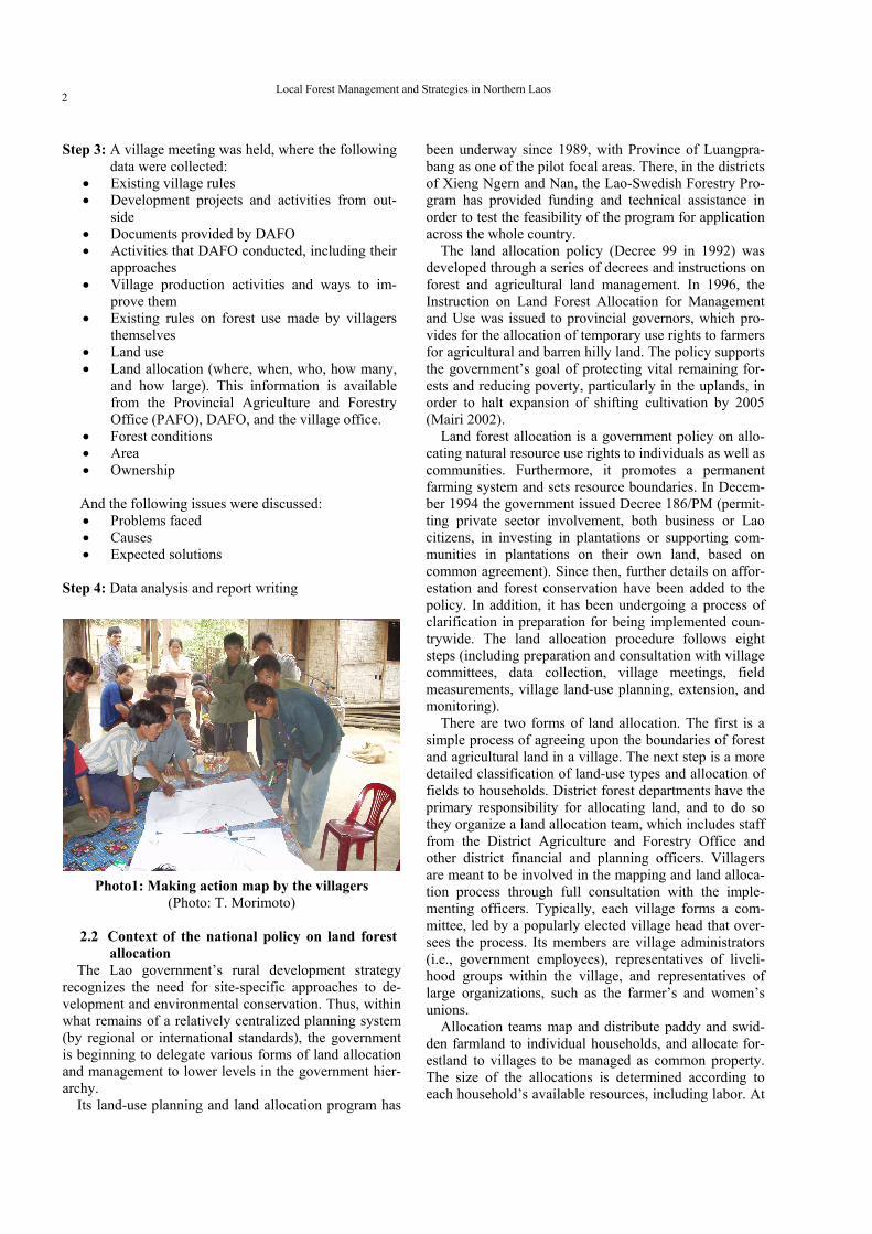
Photo1: Making action map by the villagers
(Photo: T. Morimoto) 2.2 Context of the national policy on land forest
allocation The Lao government’s rural development strategy
recognizes the need for site-specific approaches to de-velopment and environmental conservation. Thus, within what remains of a relatively centralized planning system (by regional or international standards), the government is beginning to delegate various forms of land allocation and management to lower levels in the government hier-archy.
Its land-use planning and land allocation program has
been underway since 1989, with Province of Luangpra-bang as one of the pilot focal areas. There, in the districts of Xieng Ngern and Nan, the Lao-Swedish Forestry Pro-gram has provided funding and technical assistance in order to test the feasibility of the program for application across the whole country.
The land allocation policy (Decree 99 in 1992) was developed through a series of decrees and instructions on forest and agricultural land management. In 1996, the Instruction on Land Forest Allocation for Management and Use was issued to provincial governors, which pro-vides for the allocation of temporary use rights to farmers for agricultural and barren hilly land. The policy supports the government’s goal of protecting vital remaining for-ests and reducing poverty, particularly in the uplands, in order to halt expansion of shifting cultivation by 2005 (Mairi 2002).
Land forest allocation is a government policy on allo-cating natural resource use rights to individuals as well as communities. Furthermore, it promotes a permanent farming system and sets resource boundaries. In Decem-ber 1994 the government issued Decree 186/PM (permit-ting private sector involvement, both business or Lao citizens, in investing in plantations or supporting com-munities in plantations on their own land, based on common agreement). Since then, further details on affor-estation and forest conservation have been added to the policy. In addition, it has been undergoing a process of clarification in preparation for being implemented coun-trywide. The land allocation procedure follows eight steps (including preparation and consultation with village committees, data collection, village meetings, field measurements, village land-use planning, extension, and monitoring).
There are two forms of land allocation. The first is a simple process of agreeing upon the boundaries of forest and agricultural land in a village. The next step is a more detailed classification of land-use types and allocation of fields to households. District forest departments have the primary responsibility for allocating land, and to do so they organize a land allocation team, which includes staff from the District Agriculture and Forestry Office and other district financial and planning officers. Villagers are meant to be involved in the mapping and land alloca-tion process through full consultation with the imple-menting officers. Typically, each village forms a com-mittee, led by a popularly elected village head that over-sees the process. Its members are village administrators (i.e., government employees), representatives of liveli-hood groups within the village, and representatives of large organizations, such as the farmer’s and women’s unions.
Allocation teams map and distribute paddy and swid-den farmland to individual households, and allocate for-estland to villages to be managed as common property. The size of the allocations is determined according to each household’s available resources, including labor. At
PHENGSOPHA and MORIMOTO 3
the end of the process, the village committee and district authorities sign a land-use agreement that makes the vil-lage responsible for monitoring and implementation, un-der supervision of the district authorities. The committee creates and posts land-use maps in the village as a refer-ence for ongoing natural resource management decisions.
A village forest volunteer assists the land allocation team and the farmers with forest classification and for-est-use planning, and also serves as a channel of commu-nication between the District Agriculture and Forest Of-fice and the village to facilitate the collection and man-agement of information. In practice, however, the fol-low-up steps of monitoring, assessing, and providing
extension support remain high-priority challenges for the land allocation program (Viphakone 1999).
2.3 Natural resource management policy at the district level
2.3.1 Policy documents All policies from the central government are first
passed through PAFO for consideration and then as-signed to DAFO for implementation. In reality, the dis-trict office are supposed to assess the possibility of im-plementation and adapt to suit local situations, but be-cause of shortages in staff and capabilities, certain poli-cies have not yet been implemented, with DAFO having simply distributed copies of the documents to villages.
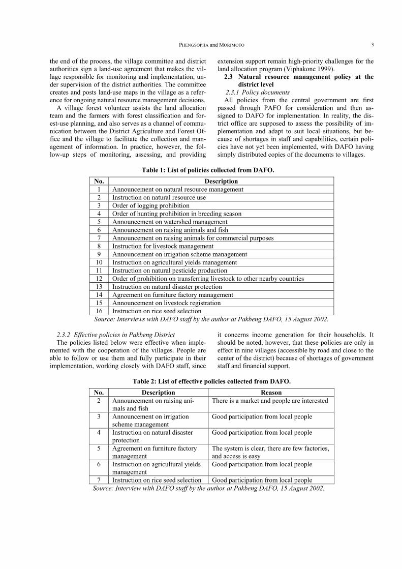
Table 1: List of policies collected from DAFO.
No. Description 1 Announcement on natural resource management 2 Instruction on natural resource use 3 Order of logging prohibition 4 Order of hunting prohibition in breeding season 5 Announcement on watershed management 6 Announcement on raising animals and fish 7 Announcement on raising animals for commercial purposes 8 Instruction for livestock management 9 Announcement on irrigation scheme management
10 Instruction on agricultural yields management 11 Instruction on natural pesticide production 12 Order of prohibition on transferring livestock to other nearby countries 13 Instruction on natural disaster protection 14 Agreement on furniture factory management 15 Announcement on livestock registration 16 Instruction on rice seed selection Source: Interviews with DAFO staff by the author at Pakbeng DAFO, 15 August 2002.
2.3.2 Effective policies in Pakbeng District The policies listed below were effective when imple-
mented with the cooperation of the villages. People are able to follow or use them and fully participate in their implementation, working closely with DAFO staff, since
it concerns income generation for their households. It should be noted, however, that these policies are only in effect in nine villages (accessible by road and close to the center of the district) because of shortages of government staff and financial support.
Table 2: List of effective policies collected from DAFO.
No. Description Reason 2 Announcement on raising ani-
mals and fish There is a market and people are interested
3 Announcement on irrigation scheme management
Good participation from local people
4 Instruction on natural disaster protection
Good participation from local people
5 Agreement on furniture factory management
The system is clear, there are few factories, and access is easy
6 Instruction on agricultural yields management
Good participation from local people
7 Instruction on rice seed selection Good participation from local people Source: Interview with DAFO staff by the author at Pakbeng DAFO, 15 August 2002.
Local Forest Management and Strategies in Northern Laos 4
2.3.3 Ineffective policies in Pakbeng District The policies are generally good in concept, but in
practice, in order to be effectively implemented they re-quire considerable input and many conditions met, such as sufficient capacity of the DAFO, technical and finan-cial support, and participation of the local people. The following are the policies that could not be implemented and followed by DAFO and the villages. DAFO did not
obtain enough input or exert enough effort on these poli-cies, again, because of lack of funds and capacity. Local people could not follow these policies, as well, or did not want to, since they would negatively affect their current incomes. Moreover, low education and awareness proved to be the main constraints to effectively implementing them.
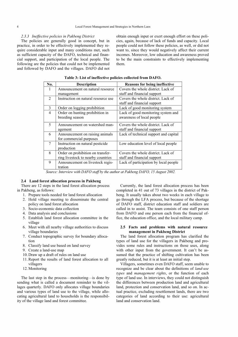
Table 3: List of ineffective policies collected from DAFO.
No. Description Reasons for being ineffective 1 Announcement on natural resource
management Covers the whole district. Lack of staff and financial support
2 Instruction on natural resource use Covers the whole district. Lack of staff and financial support
3 Order on logging prohibition Lack of good monitoring system 4
Order on hunting prohibition in breeding season
Lack of good monitoring system and awareness of local people
5 Announcement on watershed man-agement
Covers the whole district. Lack of staff and financial support
6 Announcement on raising animals for commercial purposes
Lack of technical support and capital
7 Instruction on natural pesticide production
Low education level of local people
8 Order on prohibition on transfer-ring livestock to nearby countries
Covers the whole district. Lack of staff and financial support
9 Announcement on livestock regis-tration
Lack of participation by local people
Source: Interview with DAFO staff by the author at Pakbeng DAFO, 15 August 2002.
2.4 Land forest allocation process in Pakbeng There are 12 steps in the land forest allocation process
in Pakbeng, as follows: 1. Prepare tools needed for land forest allocation 2. Hold village meeting to disseminate the central
policy on land forest allocation 3. Socio-economic data collection 4. Data analysis and conclusions 5. Establish land forest allocation committee in the
village 6. Meet with all nearby village authorities to discuss
village boundaries 7. Conduct topographic survey for boundary alloca-
tion 8. Classify land use based on land survey 9. Create a land-use map 10. Draw up a draft of rules on land use 11. Report the results of land forest allocation to all
villagers 12. Monitoring
The last step in the process—monitoring—is done by sending what is called a document reminder to the vil-lages quarterly. DAFO only allocates village boundaries and various types of land use to the village, while allo-cating agricultural land to households is the responsibil-ity of the village land and forest committee.
Currently, the land forest allocation process has been
completed in 41 out of 73 villages in the district of Pak-beng. It usually takes about two weeks in each village to go through the LFA process, but because of the shortage of DAFO staff, district education staff and soldiers are called in to assist. The team consists of one staff person from DAFO and one person each from the financial of-fice, the education office, and the local military camp.
2.5 Facts and problems with natural resource
management in Pakbeng District The land forest allocation program has clarified the
types of land use for the villagers in Pakbeng and pro-vides some rules and instructions on those uses, along with other input from the government. It can’t be as-sumed that the practice of shifting cultivation has been greatly reduced, but it is at least an initial step.
Villagers, sometimes even DAFO staff, seem unable to recognize and be clear about the definitions of land-use types and management rights, or the function of each type of land use. In interviews, they could not distinguish the differences between production land and agricultural land, protection and conservation land, and so on. In ac-tual practice, excluding resettlement lands, there are two categories of land according to their use: agricultural land and conservation land.
PHENGSOPHA and MORIMOTO 5
There is less effective implementation of the forest and land allocation program in Pakbeng because of a lack of informed specialists, and other staff from non-related sectors have been pressed into service to assist with this job, particularly people from the local military and the education office. The result is that the work is done inef-ficiently, as clearly seen by the fact that local people do not follow the policies that DAFO assigned to them. In addition, there is less input into the village by DAFO. After the initial two weeks of conducting the LFA pro-gram in a village, there was no follow up. The only thing they did was to send copies of the document ordering the village to monitor the policy. Since, in this case, the vil-lage heads themselves are conducting shifting cultivation in protected areas, the question is who will monitor whom?
Although the participation of people at one of our case study sites, Village X, for example, was adequate, the rigidity of the three-plot, three-year rotation imposed by the government on agricultural land has pushed the limits of carrying capacity. Although the logic of this approach is that the comparatively high market access enjoyed by the village will increase the system’s chances of success, the envisaged fallow period has proven ecologically un-sustainable.
Besides this, the perception of ownership of forest and land differs between the villagers and the national con-text. Article 5 of the Forest Law states that every single unit of forest and land in Laos belongs to the state, and that the government’s role is to manage and allocate those lands to organizations, communities, or households, based on the actual situation. Individuals, other than those from a government organization, have no use-rights without permission from the responsible sector (Government of Lao P.D.R. 1996), while villagers (par-ticularly in the village situated to the west of Village A) believe that the forest and land belongs to the village as common property. They acquire forest, swidden, and fallow swidden areas primarily through occupation rights (chap chong). Access to these lands is based on consen-sus and mutual respect. In the LFA process, at the meet-ing for boundary demarcation between villages, there were only a few representatives (government staff) from the village, and they signed an agreement without ap-proval from all the villagers. As a result, the villagers ignore the DAFO policy and continue with their tradi-tional practices.
Land in Village B is not common property; it belongs to individuals. If a villager wants to use land, he must ask for permission and pay a fee in the form of money or livestock. Because of not being present at the meeting to consider this issue, this land was designated as protected area and common property, and the agricultural land was allocated to each family. The owners strongly disagreed with the policy because of their loss of power and prop-erty, which rendered it ineffective.
In Oudomxay, there were many cases of problems with the military and natural resource management. At
the German Agro-Action project site (GAA), because of very good support of the project by the villagers, they were able to keep the hunting of wildlife by villagers under control, but not the military. In Village B, soldiers entered its protected area to gather wood and bamboo to construct their camp, and they used land there and in Village Pakbeng to cultivate their crops without consid-eration of the allocated land-use types, sending out the message that the land-use policy is applicable to villagers but not to soldiers. This type of occurrence reduces the local people’s trust in the policy.
2.6 DAFO innovation in Pakbeng Back in 1990 there was only one person responsible
for DAFO in the whole district. A few years later, the office had four people on staff, with each responsible for one distinct section, namely, forestry, irrigation, agricul-ture, and livestock. Unfortunately, because of this small number of people, their work was mostly limited to ad-ministrative duties and not academically focused. Fur-thermore, their work was limited to the nine villages ac-cessible by road and closest to the office.
In Pakbeng, however, the natural resources and the livelihood of people have tended to be better managed and improved, because the local government of Ou-domxay realized that substantial degradation of natural resources leads to high local poverty levels. In light of this, the shortcomings of the Pakbeng DAFO urgently need to be improved. This fiscal year (2003), DAFO re-ceived a higher staff quota than expected. Presently, there are five new staff members who are ready to work in the field. Three of them recently graduated from the National University of Laos, and the other two from technical schools. DAFO’s strategy is to develop and improve the local standard of living, starting from the district’s center, and then expand out to the remote areas. Road construction will come to the each village first, followed by education, agriculture, and health services. The International Fund for Agricultural Development (IFAD), a United Nations agency,1 has promised to be the major partner with DAFO in terms of technical and financial support, with the goal of completing this vital task in 2010.
DAFO plans to carry out the following objectives in the near future:
1 The International Fund for Agricultural Development (IFAD), a
specialized agency of the United Nations, was established as an in-ternational financial institution in 1977 as one of the major outcomes of the 1974 World Food Conference. The Conference was organized in response to the food crises of the early 1970s that primarily af-fected the Sahelian countries of Africa. The Conference resolved that “an International Fund for Agricultural Development should be es-tablished immediately to finance agricultural development projects primarily for food production in the developing countries.” One of the most important insights emerging from the Conference was that the causes of food insecurity and famine were not so much failures in food production, but structural problems relating to poverty and to the fact that the majority of the developing world’s poor populations were concentrated in rural areas.

Local Forest Management and Strategies in Northern Laos 6
• Expand the irrigation scheme to a more suitable area
• Replace poppy with other crops • Stop the practice of shifting cultivation by allo-
cating agricultural land to local people • Disseminate successful results from science ex-
periments • Increase paddy area as much as possible • Create a village development plan based on its
potential • Manage the watershed area • Encourage local participation by enhancing the
ability of the women’s union to get more in-volved in project activities
2.7 Natural resource use regulation at the village
level There are many village rules in both village A and X
(see 3-1 and 3-2), but most of them do not address natu-ral resource use. They rely on regulations from the upper hierarchy to manage the village’s natural resources, par-ticularly from DAFO. This includes the Agreement of the Minister of the Ministry of Agriculture and Forestry (MAF) No. 730/AF, Degree 63 of the Forestry Law re-garding the duties and rights of the village authority (MAF 1996), and DAFO regulations on the use of Vil-lage A’s resources, land, and forest.
The success of effectively implementing these rules depends, in part, on the density of the population. In Vil-lage A, people do not have any problem following the DAFO forest and land-use regulations because there are only 12 households conducting agricultural activities in the village area. The other 24 households cultivate their crops on the other side of the Mekong River, which be-longs to a village in the Ngeun District of Sayaburi Province, because the land allocated by DAFO is too far from their houses.
The villagers do not strictly adhere to certain forest rules, however, particularly the restrictions on felling trees and bamboo for house-building. These materials they still take freely from the nearby forest. This is be-cause the villagers do not clearly understand the defini-tions and differences between protected area, reserve forest, production forest, and regeneration forest. More-over, outsiders (the military in particular) also engage in harvesting these materials for their own construction needs. Because of the difficulty in accessing the produc-tive forest, the village authority allowed them to harvest in the protected area. Furthermore, villagers from nearby villages would not acknowledge the village boundaries, because they were not included in the decision-making process.
People in Village X don’t follow the regulations either, because the villagers have no choice. The land that used to be their swidden area was re-assigned as protected area for the Houaykasane watershed. And the land they have available for agricultural production is not large enough and has poor soil conditions. Additionally,
DAFO didn’t consider the existing land tenure system in this village. In fact, most of the land in the village be-longs to only two owners, and if anyone wants to culti-vate land, they have to ask for permission and pay a fee in the form of money or a domestic animal. The LFA policy eradicated this system without any compensation to the owners, and thus they strongly disagreed with it.
3. Case study
3.1 Village selection The province of Oudomxay is situated in the north of
Laos, and is famous for its large swidden areas. People here engage in swidden cultivation and other agriculture for cash income. In this report, the two ways that the vil-lagers commonly use to generate income, vegetable growing and animal husbandry, will be discussed below.
3.2 Methodology Several methodologies were utilized in this study. Key informant interview In order to clarify the situations in the villages, several
general questions were prepared for the village head and deputies. After basic information was collected, the vil-lagers were asked to gather to discuss matters with the research members.
Semi-structured interview In addition, in order to better understand their way of
life, household interviews were conducted with half of the families. A checklist of key questions was prepared in advance.
Wealth ranking The criteria of the wealth for the villagers were inves-
tigated, and the households were divided into the three groups: rich, medium, and poor. The criteria varied in each village, but the people most often pointed out house materials, workforce, livestock, and legacies as measures of wealth.
3.3 Village A 3.3.1 General description Village A is located near the Mekong River, about 380
meters above sea-level. The other side of the river is mountainous and belongs to the neighboring province.
The population here is 293 people that live in 36 houses, and they belong to the Khamu ethnic group, which accounts for 58 percent of the people in the prov-ince (IRAP 1996). This is a resettlement village, built in 1995 with encouragement from the local government to get people living in the upper mountain areas to come down to live on the flatlands. There has been only one sanitation project built so far, a toilet construction project by the World Bank in 2002.
The people’s main source of income comes from rais-ing vegetables such as pumpkins and sesame. They also
PHENGSOPHA and MORIMOTO 7
gather NTFPs (non-timber forest products).
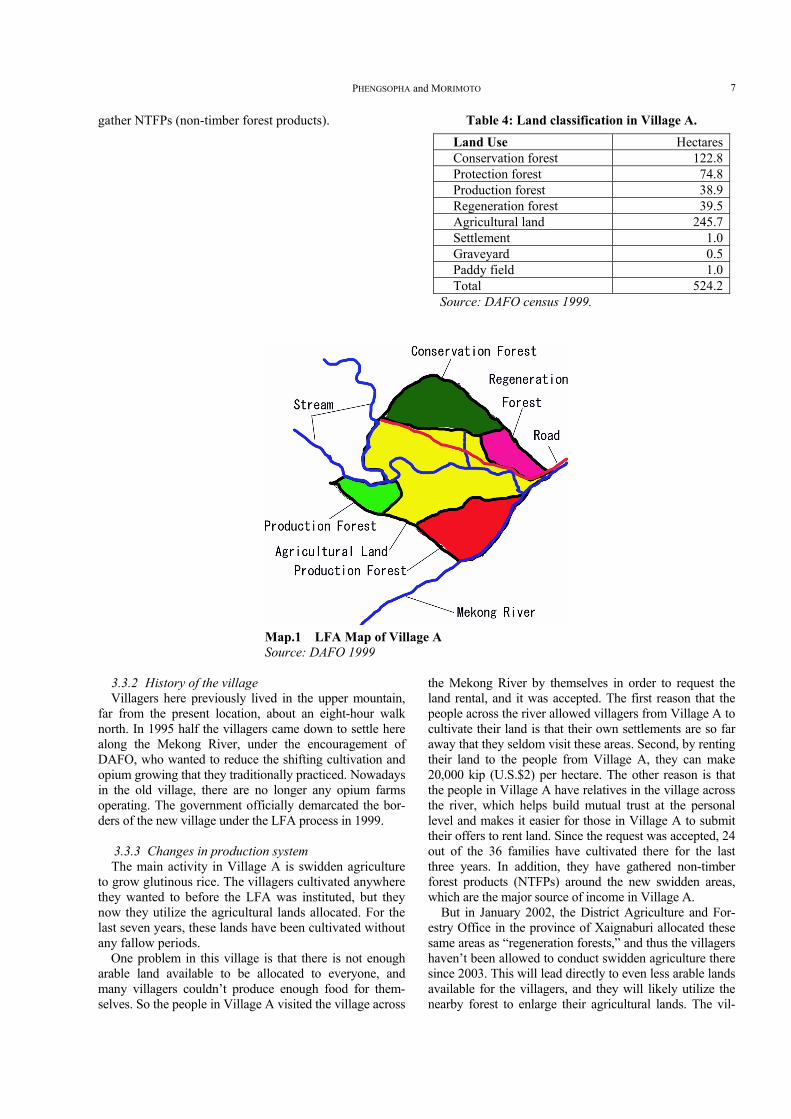
Table 4: Land classification in Village A.
Land Use HectaresConservation forest 122.8Protection forest 74.8Production forest 38.9Regeneration forest 39.5Agricultural land 245.7Settlement 1.0Graveyard 0.5Paddy field 1.0Total 524.2
Source: DAFO census 1999.
Map.1 LFA Map of Village A Source: DAFO 1999
3.3.2 History of the village Villagers here previously lived in the upper mountain,
far from the present location, about an eight-hour walk north. In 1995 half the villagers came down to settle here along the Mekong River, under the encouragement of DAFO, who wanted to reduce the shifting cultivation and opium growing that they traditionally practiced. Nowadays in the old village, there are no longer any opium farms operating. The government officially demarcated the bor-ders of the new village under the LFA process in 1999.
3.3.3 Changes in production system The main activity in Village A is swidden agriculture
to grow glutinous rice. The villagers cultivated anywhere they wanted to before the LFA was instituted, but they now they utilize the agricultural lands allocated. For the last seven years, these lands have been cultivated without any fallow periods.
One problem in this village is that there is not enough arable land available to be allocated to everyone, and many villagers couldn’t produce enough food for them-selves. So the people in Village A visited the village across
the Mekong River by themselves in order to request the land rental, and it was accepted. The first reason that the people across the river allowed villagers from Village A to cultivate their land is that their own settlements are so far away that they seldom visit these areas. Second, by renting their land to the people from Village A, they can make 20,000 kip (U.S.$2) per hectare. The other reason is that the people in Village A have relatives in the village across the river, which helps build mutual trust at the personal level and makes it easier for those in Village A to submit their offers to rent land. Since the request was accepted, 24 out of the 36 families have cultivated there for the last three years. In addition, they have gathered non-timber forest products (NTFPs) around the new swidden areas, which are the major source of income in Village A.
But in January 2002, the District Agriculture and For-estry Office in the province of Xaignaburi allocated these same areas as “regeneration forests,” and thus the villagers haven’t been allowed to conduct swidden agriculture there since 2003. This will lead directly to even less arable lands available for the villagers, and they will likely utilize the nearby forest to enlarge their agricultural lands. The vil-
Local Forest Management and Strategies in Northern Laos 8
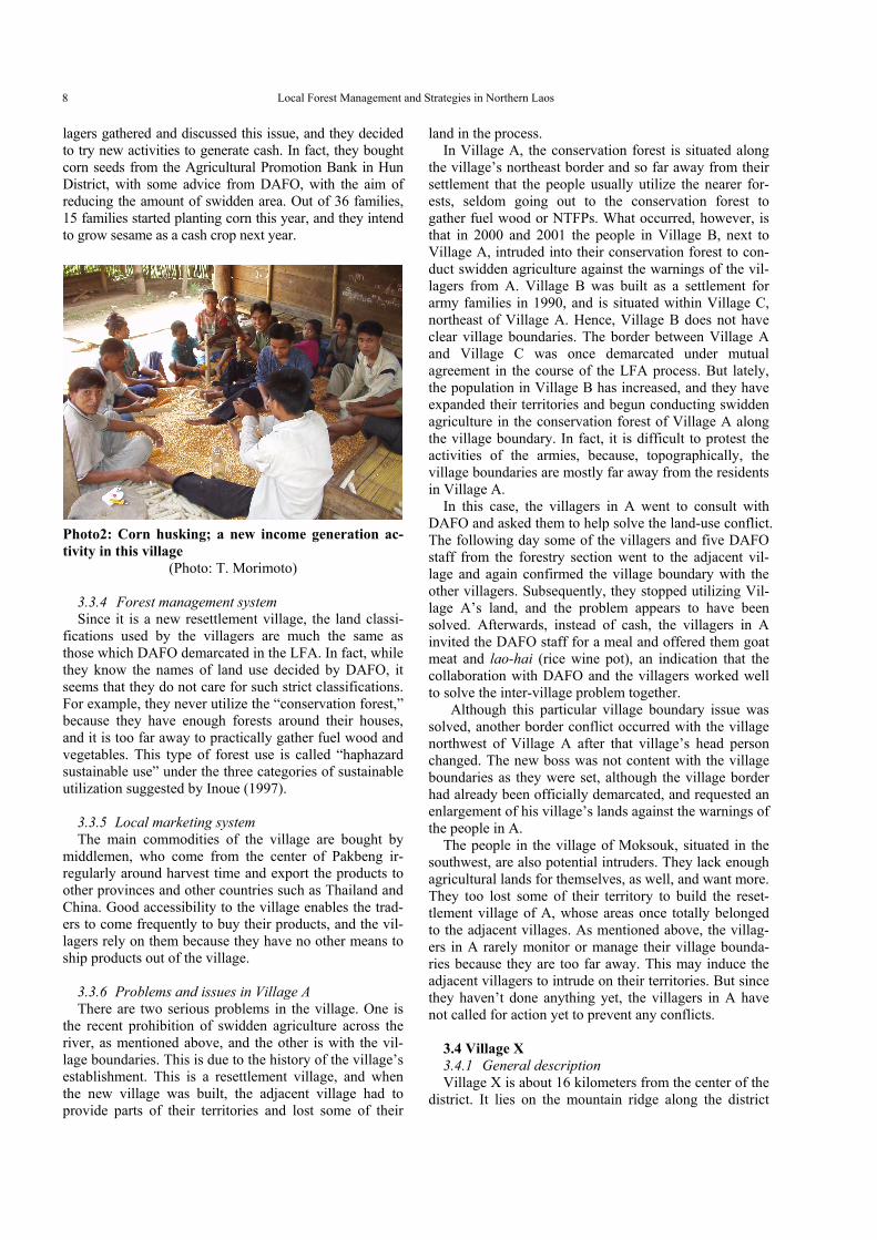
lagers gathered and discussed this issue, and they decided to try new activities to generate cash. In fact, they bought corn seeds from the Agricultural Promotion Bank in Hun District, with some advice from DAFO, with the aim of reducing the amount of swidden area. Out of 36 families, 15 families started planting corn this year, and they intend to grow sesame as a cash crop next year.
Photo2: Corn husking; a new income generation ac-tivity in this village
(Photo: T. Morimoto)
3.3.4 Forest management system Since it is a new resettlement village, the land classi-
fications used by the villagers are much the same as those which DAFO demarcated in the LFA. In fact, while they know the names of land use decided by DAFO, it seems that they do not care for such strict classifications. For example, they never utilize the “conservation forest,” because they have enough forests around their houses, and it is too far away to practically gather fuel wood and vegetables. This type of forest use is called “haphazard sustainable use” under the three categories of sustainable utilization suggested by Inoue (1997).
3.3.5 Local marketing system The main commodities of the village are bought by
middlemen, who come from the center of Pakbeng ir-regularly around harvest time and export the products to other provinces and other countries such as Thailand and China. Good accessibility to the village enables the trad-ers to come frequently to buy their products, and the vil-lagers rely on them because they have no other means to ship products out of the village.
3.3.6 Problems and issues in Village A There are two serious problems in the village. One is
the recent prohibition of swidden agriculture across the river, as mentioned above, and the other is with the vil-lage boundaries. This is due to the history of the village’s establishment. This is a resettlement village, and when the new village was built, the adjacent village had to provide parts of their territories and lost some of their
land in the process. In Village A, the conservation forest is situated along
the village’s northeast border and so far away from their settlement that the people usually utilize the nearer for-ests, seldom going out to the conservation forest to gather fuel wood or NTFPs. What occurred, however, is that in 2000 and 2001 the people in Village B, next to Village A, intruded into their conservation forest to con-duct swidden agriculture against the warnings of the vil-lagers from A. Village B was built as a settlement for army families in 1990, and is situated within Village C, northeast of Village A. Hence, Village B does not have clear village boundaries. The border between Village A and Village C was once demarcated under mutual agreement in the course of the LFA process. But lately, the population in Village B has increased, and they have expanded their territories and begun conducting swidden agriculture in the conservation forest of Village A along the village boundary. In fact, it is difficult to protest the activities of the armies, because, topographically, the village boundaries are mostly far away from the residents in Village A.
In this case, the villagers in A went to consult with DAFO and asked them to help solve the land-use conflict. The following day some of the villagers and five DAFO staff from the forestry section went to the adjacent vil-lage and again confirmed the village boundary with the other villagers. Subsequently, they stopped utilizing Vil-lage A’s land, and the problem appears to have been solved. Afterwards, instead of cash, the villagers in A invited the DAFO staff for a meal and offered them goat meat and lao-hai (rice wine pot), an indication that the collaboration with DAFO and the villagers worked well to solve the inter-village problem together.
Although this particular village boundary issue was solved, another border conflict occurred with the village northwest of Village A after that village’s head person changed. The new boss was not content with the village boundaries as they were set, although the village border had already been officially demarcated, and requested an enlargement of his village’s lands against the warnings of the people in A.
The people in the village of Moksouk, situated in the southwest, are also potential intruders. They lack enough agricultural lands for themselves, as well, and want more. They too lost some of their territory to build the reset-tlement village of A, whose areas once totally belonged to the adjacent villages. As mentioned above, the villag-ers in A rarely monitor or manage their village bounda-ries because they are too far away. This may induce the adjacent villagers to intrude on their territories. But since they haven’t done anything yet, the villagers in A have not called for action yet to prevent any conflicts.
3.4 Village X 3.4.1 General description Village X is about 16 kilometers from the center of the
district. It lies on the mountain ridge along the district
PHENGSOPHA and MORIMOTO 9
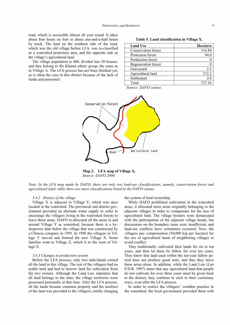
road, which is accessible almost all year round. It takes about four hours on foot or about one-and-a-half hours by truck. The land on the southern side of the road, which was the old village before LFA, was re-classified as a watershed protection area, and the opposite side as the village’s agricultural land.
The village population is 480, divided into 58 houses, and they belong to the Khamu ethnic group, the same as in Village A. The LFA process has not been finished yet, as is often the case in this district because of the lack of funds and personnel.
Table 5. Land classification in Village X.
Land Use HectaresConservation forest 316.84Protection forest 94.0Production forest 0Regeneration forest 0Graveyard 2.5Agricultural land 312.2Settlement 2.0Total 727.54
Source: DAFO census
Map 2. LFA map of Village X. Source: DAFO 2000
Note: In the LFA map made by DAFO, there are only two land-use classifications, namely, conservation forest and agricultural land, while there are more classifications listed in the DAFO census.
3.4.2 History of the village Village X is adjacent to Village Y, which was once
located in the watershed. The provincial and district gov-ernment provided an alternate water supply in order to encourage the villagers living in the watershed forests to leave these areas. DAFO re-allocated all the areas in and around Village Y as watershed, because there is a hy-dropower dam below the village that was constructed by a Chinese company in 1995. In 1998 the villagers in Vil-lage Y moved and formed the new Village X. Some families went to Village Z, which is to the west of Vil-lage X.
3.4.3 Changes in production system Before the LFA process, only two individuals owned
all the land in this village. The rest of the villagers had no arable land and had to borrow land for cultivation from the two owners. Although the Land Law stipulates that all land belongs to the state, the village territories were possessed personally at that time. After the LFA process, all the lands became common property and the usufruct of the land was provided to the villagers, totally changing
the system of land ownership. While DAFO prohibited cultivation in the watershed
areas, it allocated more areas originally belonging to the adjacent villages in order to compensate for the loss of agricultural land. The village borders were demarcated with the participation of the adjacent village heads, but discussions on the boundary issue were insufficient, and land-use conflicts have sometimes occurred. Now, the villagers pay compensation (50,000 kip per hectare) for the use of agricultural lands of neighboring villages to avoid conflict.
They traditionally cultivated their lands for six to ten years, and then let them lie fallow for over ten years. They know that land used within the ten-year fallow pe-riod does not produce good soils, and thus they leave these areas alone. In addition, while the Land Law (Lao P.D.R. 1997) states that any agricultural land that people do not cultivate for over three years must be given back to the district, they continue to stick to their customary ways, even after the LFA process.
In order to restrict the villagers’ swidden practice in the watershed, the local government provided them with
Local Forest Management and Strategies in Northern Laos 10
grocery shops as an off-farm activity to produce cash income. Unfortunately, this plan failed because of a lack of capital, and outsiders from Pakbeng came in to run the
business. So the majority of the villagers returned to their former areas and began conducting swidden agriculture again.
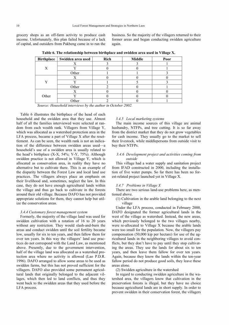
Table 6. The relationship between birthplace and swidden area used in Village X.
Birthplace Swidden area used Rich Middle Poor X 3 3 1 Y 0 0 1 X
Other 1 1 3 X 0 0 0 Y 1 5 3 Y
Other 2 0 1 X 0 0 0 Y 0 0 0 Other
Other 2 0 1 Source: Household interviews by the author in October 2002.
Table 6 illustrates the birthplace of the head of each household and the swidden area that they use. Almost half of all the families interviewed were selected at ran-dom from each wealth rank. Villagers from Village Y, which was allocated as a watershed protection area in the LFA process, became a part of Village X after the reset-tlement. As can be seen, the wealth rank is not an indica-tion of the difference between swidden areas used—a household’s use of a swidden area is usually related to the head’s birthplace (X-X, 54%; Y-Y, 75%). Although swidden practice is not allowed in Village Y, which is allocated as conservation area, in reality they have no alternative but to cultivate there. This is an example of the disparity between the Forest Law and local land use practices. The villagers always place an emphasis on their livelihood and, sometimes, neglect the law. In this case, they do not have enough agricultural lands within the village and thus go back to cultivate in the forests around their old village. Because DAFO has not provided appropriate solutions for them, they cannot help but util-ize the conservation areas.
3.4.4 Customary forest management system Formerly, the majority of the village land was used for
swidden cultivation with a rotation of 16 to 20 years without any restriction. They would slash-and-burn the areas and conduct swidden until the soil fertility became low, usually for six to ten years, and then fallow them for over ten years. In this way the villagers’ land use prac-tices do not correspond with the Land Law, as mentioned above. Presently, due to the government intervention, half of the village land was allocated as a watershed pro-tection area where no activity is allowed (Lao P.D.R. 1996). DAFO arranged to allow some areas to be used as swidden farms, but this has not proved sufficient for the villagers. DAFO also provided some permanent agricul-tural lands that originally belonged to the adjacent vil-lages, which then led to land conflicts, and thus they went back to the swidden areas that they used before the LFA process.
3.4.5 Local marketing systems The main income sources of this village are animal
husbandry, NTFPs, and tree cutting. It is so far away from the district market that they do not grow vegetables for cash income. They usually go to the market to sell their livestock, while middlepersons from outside visit to buy their NTFPs.
3.4.6 Development project and activities coming from
outside This village had a water supply and sanitation project
from IFAD constructed in 2000, including the installa-tion of five water pumps. So far there has been no for-est-related project launched yet in Village X.
3.4.7 Problems in Village X There are two serious land-use problems here, as men-
tioned above. (1) Cultivation in the arable land belonging to the next
village Under the LFA process, conducted in February 2000,
DAFO designated the former agricultural lands in the west of the village as watershed. Instead, the new areas, which previously belonged to the two villages nearby, were re-allocated to Village X because the arable lands were too small for the population. Now, the villagers pay compensation (50,000 kip per hectare) for use of the ag-ricultural lands in the neighboring villages to avoid con-flicts, but they don’t have to pay until they stop cultivat-ing the areas. They use the lands for about six to ten years, and then leave them fallow for over ten years. Again, because they know the lands within the ten-year fallow period do not produce good soils, they leave these areas alone.
(2) Swidden agriculture in the watershed In regard to conducting swidden agriculture in the wa-
tershed area, the villagers know that cultivation in the preservation forests is illegal, but they have no choice because agricultural lands are in short supply. In order to prevent swidden in their conservation forest, the villagers
PHENGSOPHA and MORIMOTO 11
created their own village rules on 25 May 2001. Accord-ing to them, if anyone cultivates in the watershed forests, they must pay a fine of 50,000 to 70,000 kip ($5 to $7) to the village. But in fact, this measure is a dead issue, be-cause they continue cultivating in the preservation forests without any penalties, and DAFO doesn’t have the funds to monitor the forests and can’t prevent their illegal farming.
3.5 Conclusion Government policy does not always correspond to lo-
cal realities in rural areas all over the world. In the two cases examined, the local people have sought solutions for making a living. The former example is one of a vil-lage relying on the government, while the latter is se-cretly against it. It is necessary to willingly have mutual understanding between local people and the government in land-use planning. It will reduce the disparities be-tween realities and policies. In addition, it is better for government policies to be flexible enough to be able to be suited to local conditions.
Reference: -District Agriculture and Forestry Office 1999. Land
Forest Allocation Map of Village A (not published)
-District Agriculture and Forestry Office 2000. Land Forest Allocation Map of Village X (not published)
-Government of Lao P.D.R. 1996. Forest Law. Veinti-ane: Ministry of Agriculture and Forestry.
-Inoue, M. 1997. Tropical forests as commons (in Japa-nese). Environmental Sociology Research 3, pp.15–32. Tokyo: Shinyousha.
-IRAP. 1996. Integrated Rural Accessibility Planning in Lao P.D.R. - Muan Pakbeng. Vientiane: IRAP.
-Lao P.D.R. 1996. The Forestry Law (in English). Vien-tiane: Lao People’s Democratic Republic.
———. 1997. The Land Law (in English). Vientiane: Lao People’s Democratic Republic.
-Mairi, D. 2002. Decentralization - in Mainland South-east Asia. New York: World Resources Institute.
-Ministry of Agriculture and Forestry (MAF). 1996. MAF No. 822: Instruction on Land-Forest Alloca-tion for management and use. Vientiane: Lao Peo-ple’s Democratic Republic.
-Viphakone, S. 1999. Monitoring and assessing the re-sults of land zoning in Ban Nam Phak, Nan District, Luang Phabang Province. Luang Phabang: Lao-Swedish Forestry Programme.