Embed Size (px)
Citation preview

Livingston County Department of Planning
Robert A. Stanford
AICP, PEM
Principal Planner
Scott Barb
AICP, PEM
Principal Planner
Administration Building 304 E. Grand River Avenue
Suite 206 Howell, MI 48843-2323
(517) 546-7555 Fax (517) 552-2347
Web Site co.livingston.mi.us
Department Information
Kathleen J. Kline-Hudson
AICP, PEM
Director
LIVINGSTON COUNTY PLANNING COMMISSION MEETING
Wednesday, February 19, 2020 – 6:30 p.m. Administration Building, Board of Commissioners Chambers
304 East Grand River, Howell, MI 48843
Agenda
1. Call to Order
2. Pledge of Allegiance to the Flag
3. Roll and Introduction of Guests
4. Approval of Agenda – February 19, 2020
5. Approval of Meeting Minutes – January 15, 2019
6. Call to the Public
7. Zoning Reviews
A. Z-04-20 Hartland Township, Rezoning, GC to LI in Section 28
B. Z-05-20 Tyrone Township, Conditional Rezoning, FR to RE in Section 21
8. Old Business
A. Progress on visits to local planning commissions
B. Review of MSU Extension Training, Planning Commission Roles and
Responsibilities
9. New Business
10. Reports
A. Staff Reports
11. Commissioners Heard and Call to the Public
12. Adjournment 13. Optional visit to new County Planning office space

LIVINGSTON COUNTY PLANNING DEPARTMENT CASE NUMBER:
REZONING REQUEST - - Z-04-20
STAFF REPORT
COUNTY CASE NUMBER: Z-04-20 TOWNSHIP: Hartland
REPORT DATE: January 21, 2020 SECTION NUMBER: 28
STAFF ANALYSIS BY: Kathleen Kline-Hudson TOTAL ACREAGE: 1.97
APPLICANT / OWNER: Hartland Township
LOCATION: 1010 N. Old US-23, south of M-59 and north of Bergin Road
LAND USE: Sunset Acres Cabins, highway billboard, mobile homes and misc. buildings
CURRENT ZONING: REQUESTED ZONING:
GC General Commercial LI Light Industrial
PERMITTED/SPECIAL USES (Not all inclusive): PERMITTED/SPECIAL USES (Not all inclusive): Permitted: Permitted:
Retail stores, wholesale clubs, or retail centers; professional and medical offices or clinics; financial institutions with drive-through service; personal service establishments; food and beverage service establishments; outdoor seating and dining areas; business service establishments; adult day care facilities, and child care centers, preschool and day care centers; public buildings; public or private parks and open space; business and private schools operated for a profit completely within an enclosed building; churches and religious institutions; essential public services; banquet halls; funeral homes; theaters and concert halls; newspaper offices; personal fitness centers; veterinary offices.
Any use with the principal function of conducting research, design, testing and pilot or experimental product development; vocational schools and other types of technical trailing facilities; computer related services; professional & medical offices; financial institutions; publicly owned and operated facilities; essential services, buildings and storage yards; parks and open space; outdoor seating and dining areas; business services; mini warehouses; commercial greenhouses; lumber yards; public buildings; and public utility buildings.
Special: Special:
Automobile service stations; automobile sales; automobile wash; billiard halls, open air business uses; drive-in establishments for the retail delivery of products to customers in automobiles; essential service facilities; garden centers; leasing of recreational, landscaping or moving equipment; large institutional uses; motels and hotels; outdoor and indoor commercial recreation; radio and television towers; restaurants; shopping centers; automobile fueling and convenience station; automobile repair – minor.
Child day care; adult day care; indoor tennis facilities; fitness and recreation centers; urgent care facilities; motels; hotels; standard restaurants; freezer locker plants and cold storage; heliports; communication towers; outdoor storage; automobile repair.
Minimum Lot Area: 40,000 sq. ft. without sewer and 20,000 sq. ft. with sewer
Minimum Lot Area: 40,000 sq. ft.
TOWNSHIP PLANNING COMMISSION RECOMMENDATION AND PUBLIC COMMENTS:
ESSENTIAL FACILITIES AND ACCESS:
The Hartland Township Planning Commission tabled the rezoning at their October 10, 2019 meeting after the public hearing of this rezoning amendment. There were no comments from the public at the public hearing. At the subsequent January 9, 2020 meeting, the Hartland Township Planning Commission recommended Approval of the rezoning amendment.
Water:
On-site well Sewer:
On-site septic
Access: Old US-23; paved primary roadway

CASE NUMBER: Z-04-20 DATE: January 21, 2020 ANALYSIS BY: Kline-Hudson PAGE: 2
EXISTING LAND USE, ZONING AND MASTER PLAN DESIGNATION:
Land Use: Zoning: Master Plan:
Subject Site: Sunset Acres Cabins, highway billboard, mobile homes, misc. buildings
GC General Commercial Planned Industrial/R&D
To the North: Light Industrial LI Light Industrial Planned Industrial/R&D To the East: US-23 Highway, Hartland
Shores Estates (on east side of US-23)
SR Suburban Residential (on east side of US-23)
Estate Residential (on east side of US-23)
To the South: Industrial LI Light Industrial and I Industrial
Planned Industrial/R&D
To the West: Light Industrial and Agriculture
LI Light Industrial and CA Conservation Agriculture
Planned Industrial/R&D and Medium Urban Density Residential
ENVIRONMENTAL CONDITIONS:
Soils / Topography: Well-drained Miami Loam. The topography of the site is nearly level 0 to 6% slope.
Wetlands: There are no wetlands on-site.
Vegetation: Minimal landscaping.
County Priority Natural Areas:
According to the map “Livingston County’s High Quality Natural Areas”, there are no Priority 1,2 or 3 Natural Areas on-site.
TOWNSHIP MASTER PLAN DESIGNATION:
The Hartland Township Comprehensive Plan (2015) designates the site as Planned Industrial / Research and Development. The master plan defines this future land use category as follows: The word “Planned” in this designation’s name is intended to convey the Township’s intentions to partner with private developers or public entities in the creation of planned developments consistent with the provisions of the Michigan Zoning Act and the Township’s Zoning Ordinance. In anticipation of population growth and the resulting demand such growth will place upon Township services, additional nonresidential land use areas will be required. These uses will help stimulate the local economy, provide jobs, and contribute to a diverse tax base in order to facilitate Township growth and allow it to continue to provide the quality of service its residents have grown to expect. General Location. On the Future Land Use Map, PIRD has been planned for approximately 627 acres of the Township. Two distinct areas have been designated for future Planned Industrial Research and Development. These areas are the Clyde Road and US-23 interchange and the Old US-23 corridor, south of M-59.
COUNTY COMPREHENSIVE PLAN:
The 2018 Livingston County Master Plan does not direct future land use patterns, or development within Livingston County. Alternatively, it offers a county-wide land use perspective when reviewing potential rezoning amendments. The Land Use & Growth Management chapter of the plan includes decision-making recommendations regarding potential land use conflicts and promoting good land governance.

CASE NUMBER: Z-04-20 DATE: January 21, 2020 ANALYSIS BY: Kline-Hudson PAGE: 3
COUNTY PLANNING STAFF COMMENTS:
Hartland Township is initiating this rezoning request to LI Light Industrial with the intent of creating an area of compatible industrial zoning along the eastern side of Old US-23.The parcel that is adjacent to the south of this site was recently administratively rezoned by Hartland Township from PD Planned Development to LI Light Industrial (Z-51-19, November, 2019), which leaves the subject site as the only property that is not zoned Light Industrial or Industrial in an approximate 1 ½ mile swath along the east side of Old US-23. The intent of the Light Industrial zoning district states:
The LI, Light Industrial District is designed so as to primarily accommodate industrial parks, wholesale activities, warehouses, and industrial operations whose external physical effects are restricted to the area of the district and in no manner detrimentally affect any of the surrounding districts. The LI District is so structured as to permit, along with any specified uses, the manufacturing, compounding, processing, packaging, assembly and/or treatment of finished or semi-finished products from previously prepared material. It is further intended that the processing of raw material for shipment in bulk form, to be used in an industrial operation at another location is not to be permitted.
The minimum required lot size for each parcel in the LI zoning category is a lot width of 120 feet and lot area of 40,000 square feet. The subject parcel meets these lot size requirements. The Hartland Township Planning Director suggested that two additional zoning districts could be considered for this parcel: RDP Research and Development Park and I Industrial; however, the subject parcel would not meet the minimum lot area of either district (RDP 5 acres and I 10 acres). The current land uses on this parcel include Sunset Acres Cabins and two mobile homes which are functioning as rental units, and a highway billboard. These uses are not permitted or specially permitted uses in either the GC General Commercial or LI Light Industrial zoning districts. The Township Planning Director believes that this property was rezoned from HC (Highway Commercial) to GC in the 1990’s when the zoning map was updated. The residential uses on-site have been non-conforming uses for decades. The billboard sign located on the property was erected in the 1980’s and it is also a non-conforming use, as the current zoning ordinance only permits billboards in the I Industrial zoning district abutting US-23 as a special use permit. Hartland Township initiated the rezoning of the property in October 2019. The owner Jerrad Beauchamp attended the public hearing and requested that the rezoning be postponed until after the first of the year. The Planning Commission honored that request and postponed that rezoning. In December 2019, the Township became aware that the property had sold to a new company. The Township then sent written notification of the pending rezoning request to the new owner, and invited them to attend the Planning Commission meeting in January 2020. The new owner attended the meeting and the Township Planning Commission asked if he was okay with the rezoning. The new owner indicated that he desired to keep the residential units on the property and had no other plans for the property. The new owner was informed that the residential units would be considered “non-conforming” under the current GC (Commercial) zoning, as well as under the proposed LI (Light Industrial) zoning classification. The new owner indicated that he had no objections to the rezoning, since the status of the residential structures remained unchanged. The proposed LI Light Industrial rezoning is consistent with the Planned Industrial/Research and Development (PIRD) future land use designation of the Hartland Township Comprehensive Plan, although the parcels along the east site of Old US-23 are really too small to accommodate the true concept of a PIRD, which is typically a campus-like setting on a large acre site. The Comprehensive Plan acknowledges

CASE NUMBER: Z-04-20 DATE: January 21, 2020 ANALYSIS BY: Kline-Hudson PAGE: 4
COUNTY PLANNING STAFF COMMENTS:
that this type of PIRD is more suitable for the Clyde Road and US-23 Interchange Area and the plan makes the following recommendations for the Old US-23 Area:
This area has historically been used for industrial purposes and the Township should continue to support those existing light industrial/technology uses while encouraging new, complementary uses of an appropriate size and scale. Since this area is highly visible from both Old US-23 and US-23, generous landscaping and high quality architectural design should be encouraged. Outdoor storage and industrial yards should appropriately screened from view.
COUNTY PLANNING STAFF RECOMMENDATION:
APPROVAL; The proposed rezoning to LI Light Industrial will help Hartland Township achieve an area of more consistent industrial zoning along the east side of Old US-23. LI zoning is consistent with the existing industrial land use of this area and the Planned Industrial/Research Development (PIRD) master plan designation.
EXISTING LAND USE MAP:

CASE NUMBER: Z-04-20 DATE: January 21, 2020 ANALYSIS BY: Kline-Hudson PAGE: 5
FUTURE LAND USE MAP:
TOWNSHIP ZONING MAP:

CASE NUMBER: Z-04-20 DATE: January 21, 2020 ANALYSIS BY: Kline-Hudson PAGE: 6
SITE PHOTOS:
Subject Site View Looking South from Site
View Looking West from Site View Looking Southwest from Site

LIVINGSTON COUNTY PLANNING DEPARTMENT CASE NUMBER:
REZONING REQUEST - CONDITIONAL Z-05-20
STAFF REPORT
COUNTY CASE NUMBER: Z-05-20 TOWNSHIP: Tyrone Township
REPORT DATE: February 3, 2020 SECTION NUMBER: 21
STAFF ANALYSIS BY: Robert Stanford TOTAL ACREAGE: 72.39 Acres
APPLICANT / OWNER: Tyrone Four, LLC
LOCATION: East side of Runyan Lake Road, South of Center Road and North of Gordon Road
LAND USE: Currently Vacant
CURRENT ZONING: REQUESTED ZONING:
FR - Farming Residential
Conditional RE – Rural Estates with Open Space
Preservation (OSP) Option and Cluster Development Option (CDO)
PERMITTED/SPECIAL USES (Not all inclusive): PERMITTED/SPECIAL USES (Not all inclusive): Permitted: Permitted:
Agriculture, Single family dwellings, Home Occupations, Essential Services excluding outside storage, Stables, Travel trailer storage – noncommercial, Child and adult care facilities
Agriculture, Single family dwellings, Home Occupations, Essential Services excluding outside storage, Stables, Travel trailer storage – noncommercial, Child and adult care facilities
Special: Special:
Agri-Business, Churches and Schools, Public and private cemeteries, Golf Courses, Colleges and Universities, Airports, Feedlots, Recreational Areas, Kennels, Campgrounds, Care Facilities, Public utilities, Hospitals, Livestock sales, Contractor’s Limited Storage, Medical Marijuana Caregiver Operation, Zoological Park or Wildlife Sanctuary, Utility-scale Solar Energy Facilities
Agri-Business, Churches and Schools, Public and private cemeteries, Golf Courses, Colleges and Universities, Airports, Feedlots, Recreational Areas, Kennels, Campgrounds, Care Facilities, Public utilities, Hospitals, Livestock sales, Contractor’s Limited Storage, Medical Marijuana Caregiver Operation
Minimum Lot Area: 3 acres
Minimum Lot Area: 1.75 acres
Open Space Preservation Option / Cluster Development Option:
Section 8.02 E.1.
Lots may be reduced in area below the lot size required by the residential zoning district in which the subdivision is located. Lot area reductions may be up to fifty (50) percent in the FR and RE Districts according to the following schedule:
Zoning District
Minimum Lot Area in Zoning District
Proposed Minimum Lot Area with Cluster Option
Minimum Open Space Required per Proposed Lot with Cluster Option
FR 3 acres 1.5 acres 1.5 acres
RE 1.75 acres 0.875 acre 0.875 acre
NOTE REGARDING CLUSTER AND OPEN SPACE PRESERVATION OPTIONS:
All land remaining after lot area reductions shall be preserved and maintained in perpetuity for its scenic value or for recreation and conservation purposes. Such open space shall be protected to remain as open space by a conservation easement, plat dedication, restrictive covenant, or other legal mechanism that runs with ownership of the land.

ANALYSIS BY: Stanford DATE: February 3, 2020 CASE NUMBER: Z-05-20 PAGE: 2
TOWNSHIP PLANNING COMMISSION RECOMMENDATION AND PUBLIC COMMENTS:
The Tyrone Township Planning Commission recommended DISAPPROVAL / DENIAL of this Conditional Rezoning at its December 10, 2019 Public Hearing, as follows: While the proposed plan may have merit if it were a concept plan and appropriate revisions were made to comply with our Zoning Ordinance and State statute prior to final site plan approval, this is a request for a conditional rezoning – therefore the site plan submitted is the only plan that may be considered. The Planning Commission finds the deviations requested from the township’s zoning requirements are not justified by the offsetting concessions offered and do not comply with the requested underlying zoning district requirements (RE). Further, the plan as currently proposed cannot comply with the statutory requirement for at least 50% perpetually undeveloped open space left in its natural state. In its motion, the Planning Commission chose to focus on its duty to not recommend or approve developments that violate state law, in this case specifically the Planned Unit Development Option requirements set forth in PA 110 of 2006 (Michigan Zoning Enabling Act –MZEA – MCL125.3503), the Open Space Preservation Option – MCL125.3506). A motion was passed 5-2 to recommend Denial of the Conditional Rezoning offer because the Planning Commission believes the proposed development does not comply with the planned unit development and open space requirements set forth by the MZEA as well as when utilizing the Township’s Cluster Development Option (CDO) in reference to Township Ordinance Section 21.51 (C) with regard to the provision’s application of allowable open space in the rear yard setback.
ESSENTIAL FACILITIES AND ACCESS:
Water: The site will be serviced by private well.
Sewer: The site will be serviced by a proposed private community septic to serve the development only.
Access: Access to subject site via Runyan Lake Road
EXISTING LAND USE, ZONING AND MASTER PLAN DESIGNATION:
Land Use: Zoning: Master Plan:
Subject Site: Vacant FR Low Density Residential
To the North: Tyrone Township Hall and SF Residential FR Low Density Residential
To the East: Single Family Residential FR Low Density Residential
To the South: Utility Easement and SF Residential FR Low Density Residential
To the West: US-23 Highway N/A N/A
ENVIRONMENTAL CONDITIONS:
Soils / Topography: Hillsdale-Miami loams (6 to 12 percent slope) and Miami loams (6 to 12 percent slopes) are the predominant soils on site with varying slopes. These soil types are well drained and have good stability for building. Topography on site is fairly level to gently sloping, 6-12 percent slopes.
Wetlands: The National Wetlands Inventory (NWI) indicates that there are several (5) small (less than 2 acres) unregulated palustrine emergent wetlands scattered throughout the central portions of the entire subject site. There is also a portion of a larger regulated palustrine forested wetland (approximately 3 acres of a total 12 acre) that encroaches into the far northeast portion of the subject site
Vegetation: The subject properties are entirely wooded.
County Priority Natural Areas:
According to the map "Livingston County's High Quality Natural Areas”, the entire 72-acre subject parcel contains a Priority Level 3 Natural Area.
TOWNSHIP MASTER PLAN DESIGNATION:
The Future Land Use plan and map of Tyrone Township designates the site as Low Density Single Family Detached Residential per the future land use map. The Township Master Plan describes this area in the following manner (pg. 92):
Low Density Single Family Detached Residential. This category will permit single family residential development at a density of 1.5 to 3 acres per dwelling unit. This designation can be found in portions of the southeast part of the Township, where residential uses are appropriate but higher densities are not advisable due to infrastructure concerns.
Additionally, the Master Plan describes Open Space Preservation in the following manner (pg. 91):
The Township continues to be dedicated to preservation of open space, particularly in accordance with its program that has been pursued since 1997. The Planning Commission also recognizes the obligation in the Zoning Enabling Act to provide open space in cluster development for all residential land zoned for development at 2 or fewer dwellings per acre where no public sanitary sewers exist and 3 or fewer dwellings per acre with public sewers. As required by the State of Michigan, the Zoning Ordinance provides a cluster option for residential development, if open space is preserved equal to at least 50% of the total land area that is developed. Maintenance of the open space must be established in perpetuity.

ANALYSIS BY: Stanford DATE: February 3, 2020 CASE NUMBER: Z-05-20 PAGE: 3
COUNTY COMPREHENSIVE PLAN:
The 2018 Livingston County Master Plan does not direct future land use patterns, or development within Livingston County. Alternatively, it offers a county-wide land use perspective when reviewing potential rezoning amendments. The Land Use & Growth Management chapter of the plan includes decision-making recommendations regarding potential land use conflicts and promoting good land governance.
Conditional rezonings are beginning to be a recent trend in Livingston County (four proposed in 2019). If petitioners see this tool as simply a means to get around existing zoning standards to get what they want, this is not the intent of the provision, most importantly at the State statute level. Therefore it is vitally important that petitioners clearly understand the intent of the conditional rezoning tool as well as townships standing firm within the prescribed rules and regulations of their local zoning ordinance and provisions of their Master Plan, in order to make sure they are getting the best and most desired development possible that is a benefit to the entire local community in the end.
COUNTY PLANNING STAFF COMMENTS:
The applicants have requested application consideration by the Tyrone Township Planning Commission for a conditional rezoning to create a development known as the “Sanctuary at Tyrone”. The proposed development is 72.39 acres, located in Section 21 of the township, on the east side of Runyan Lake Road, South of Center Road and North of Gordon Road. HISTORY OF THE PROJECT:
The applicant originally proposed to develop 31 condominium units (site condominium) on a 62 acre parcel in the FR Farming Residential district. Zoning requirements in effect at that time required 2 acre minimum lots with an additional 50% of the developed area being set aside as open space preserved in perpetuity. The applicant stated they wished to utilize the Cluster Development Option (CDO) as set forth in our Zoning Ordinance, and in compliance with PA 110 of 2006, the Michigan Zoning Enabling Act (the “Act”). As a result, lot sizes could be reduced by not more than 50%, and open space must be established for not less than 50% of the land area. Also required by the Act is compliance with the dimensional requirements of the underlying zoning district. As is typical with concept plan approval, the applicant at this point must simply provide a plan that could reasonably be executed. Historically, concept plans undergo various modifications to address infrastructure needs, approving agency requirements, identification of regulated wetlands, and other minor site plan modifications deemed necessary. Consistent with this historical approach and as set forth in Table 21.2 of the township zoning ordinance, the township planning commission originally granted concept approval of the plan was on December 19, 2017. After no development activity was undertaken, the applicant submitted a request to the township to extend the concept plan for 120 days. The extension was granted on November 20, 2018. A further 120-day extension was granted on March 5, 2019. During the period of time the extensions were granted, in March of 2018, Tyrone Township amended its zoning ordinance, which changed the minimum lot area in the FR district from a minimum of 2.0 acres to 3.0 acres. Applicant purchases the additional 10 acres in June 2019. During July of 2019, the applicant submitted a modified site plan which now included another adjacent 10 acre parcel. The new site plan proposes 36 condominium units on 72 total acres, again utilizing CDO, and utilizing the previous FR district minimum lot size requirement rather than the current requirement. When the applicant was advised the new plan had similar challenges and limitations as the prior plan in addition to the minimum lot size change, the applicant sought a conditional rezoning of the two parcels from FR to RE (Rural Estates) along with utilization of the CDO. Key issues with Z-05-20: “Sanctuary At Tyrone”
72.39 Acres – 36 proposed units under RE with OSD option as opposed to 24 units under FR zoning
Requested Zoning – RE: Rural Estates with Cluster Development Option (CDO)
RE: 1.75 Acres (standard) to 0.875 Acres (Open Space/Cluster Development)
Required Open Space: 36.195 acres (50% of development)
Proposed Developed Open Space: 26.68 Acres (36.8 % of development)
Proposed Lot Open Space: 11.18 Acres (15.4% of development)
Total Proposed Open Space: 37.86 Acres (52% of development)
Township Planner has indicated to the Township Planning Commission that the conditional rezoning process is an offer of a specific development and use (the site plan) if the rezoning is granted, and no other. Therefore the site plan as submitted must be considered the final site plan that would be approved, rather than a concept plan which might be modified to resolve developmental concerns.
Must comply with proposed underlying zoning: RE with CDO option: From 1.75 to 0.875 acres minimum if CDO is applied.
Township not required to accept conditional rezoning.

ANALYSIS BY: Stanford DATE: February 3, 2020 CASE NUMBER: Z-05-20 PAGE: 4
A. Project compliance with Township Master Plan
The Future Land Use plan and map of Tyrone Township designates the site as Low Density Single Family Detached Residential per the future land use map. The Township Master Plan describes this area in the following manner (pg. 92):
Low Density Single Family Detached Residential. This category will permit single family residential development at a
density of 1.5 to 3 acres per dwelling unit. This designation can be found in portions of the southeast part of the Township,
where residential uses are appropriate but higher densities are not advisable due to infrastructure concerns.
Additionally, the Master Plan describes Open Space Preservation in the following manner (pg. 91): The Township continues to be dedicated to preservation of open space, particularly in accordance with its program that has been
pursued since 1997. The Planning Commission also recognizes the obligation in the Zoning Enabling Act to provide open space in
cluster development for all residential land zoned for development at 2 or fewer dwellings per acre where no public sanitary sewers
exist and 3 or fewer dwellings per acre with public sewers. As required by the State of Michigan, the Zoning Ordinance provides a
cluster option for residential development, if open space is preserved equal to at least 50% of the total land area that is developed.
Maintenance of the open space must be established in perpetuity.
It must be remembered that the Master Plan is a flexible document. In addition to a Plan meeting all State and local planning/development regulations, flexible zoning tools, techniques and options are made available to local municipalities (i.e., cluster development option (CDO), planned unit development (PUD), open space planning (OSP) in order to better achieve sound planning decisions and good/compatible development patterns. However, the Plan must still meet all underlying zoning requirements.
B. Project compliance with Livingston County “High Quality Natural Features Inventory” provisions
Entire 72-acre site has been identified as a Priority Level Three (3) Natural Area, which is part of a total 132-acre natural area that extends well past the boundaries of this subject parcel.
The development as proposed:
(a) Under current FR: Farming Residential zoning, 3 acre minimum lots are required, so the proposed developmental area, if developed similarly, is entitled up to 72/3 = 24 lots minus any infrastructure required for access, wetlands, etc. The developer is proposing 36 lots.
(b) Existing adjacent development is characteristically 2.5 – 10+ acres per dwelling unit. The developer is proposing 1.0 acre lots.
(c) The developer is requesting rezoning from FR: Farming Residential (3 acre) to RE: Rural Estates (1.75 acre), then is proposing to apply Cluster Development Option (0.875 acre). The proposed lot sizes do not comply with RE dimensional requirements, and are much more similar to R-1 Zoning District dimensional standards (developing FR lots using R-1 standards).
(d) CDO requires a minimum of 50% open space preservation. The developer is only providing a proposed 50% open space, the absolute minimum required by law. Nothing is being proposed to preserve natural features outside of the minimum – rather it appears that the proposed development is attaining the absolute maximum number of lots which can be developed.
(e) Of the open space required, the developer proposes approximately 25% of the land area of each of the 36 lots, accounting for the entire required rear yard setback, which has already been reduced below RE developmental standards, as open space. 0.25 acre x 36 lots = approximately 9 acres of the required 36 acres of open space, 25%, would be difficult to enforce and most likely will not be retained as open space over time.
(f) Nothing proposed makes any attempt to preserve the majority of the land, as is desired through the County Natural Features Inventory. The proposal appears to maximize the number of lot/units that can be created within the development, and utilizes methods that most likely will result in some open space intended to be preserved (the 25% rear yard lot open space as proposed) to being used ultimately for other purposes.
(g) There are significant wetlands throughout the site, which act as important groundwater recharge areas and significant wildlife habitat. The proposed development does not appear to take any further steps to design around these important natural features, other than leaving the large wetland area to the northeast(presumed regulated) as is. The other significant wetland areas on site are mostly absorbed (i.e., filled and graded) into the overall development as building sites rather than integrated and preserved.

ANALYSIS BY: Stanford DATE: February 3, 2020 CASE NUMBER: Z-05-20 PAGE: 5
C. Project compliance with State and township open space requirements for CDO State Requirements: MZEA, MCL 125.3506. Open Space Preservation MCL 125.3506 Open space preservation.
Sec. 506. (1) Subject to subsection (4) and section 402, a qualified local unit of government shall provide in its zoning ordinance that land zoned
for residential development may be developed, at the option of the landowner, with the same number of dwelling units on a smaller portion of the
land than specified in the zoning ordinance, but not more than 50% for a county or township or 80% for a city or village, that could otherwise be
developed, as determined by the local unit of government under existing ordinances, laws, and rules on the entire land area, if all of the following
apply:
Under MZEA, Open space preservation is a development tool that local municipalities must make available, however, it does not establish development by right, it is only an option that may be utilized by the landowner in order to develop land in an alternative manner than by right (standard rezoning).
The statute does not specify the number of units.
All underlying zoning requirements are to be met (a) The land is zoned at a density equivalent to 2 or fewer dwelling units per acre or, if the land is served by a public sewer system, 3 or fewer
dwelling units per acre. (b) A percentage of the land area specified in the zoning ordinance, but not less than 50% for a county or township or
20% for a city or village, will remain perpetually in an undeveloped state by means of a conservation easement, plat dedication, restrictive
covenant, or other legal means that runs with the land, as prescribed by the zoning ordinance.
“Undeveloped state”: Open Space proposed in rear yard setbacks. HOA Maintenance Agreement. No real way for township to enforce this other than requiring a Maintenance Agreement in the Zoning Ordinance. This area could be cleared at some point by a home owner.
(3) The development of land under subsection (1) is subject to other applicable ordinances, laws, and rules, including rules relating to suitability
of groundwater for on-site water supply for land not served by public water and rules relating to suitability of soils for on-site sewage disposal
for land not served by public sewers.
(5) The zoning ordinance provisions required by subsection (1) shall be cited as the "open space preservation" provisions of the zoning
ordinance.
Strict interpretation of Item #5: Township Ordinance 8.01 Parallel Plan is required – has one been submitted? Tyrone Township says, no.
Township Requirements:
Article 8 Open Space Preservation Option (OSP)
SECTION 8.00 INTENT
The intent of open space development is to provide a procedure for residential development that will result in concentrated and enhanced living
environments OSP development can permit more economical residential development and encourage a variety of architectural types and styles
for residential dwellings. It will provide a basis for ingenuity and originality in residential lot and street design and development and will
preserve open space to serve recreational, scenic, and public service purposes. The provisions have been modified in compliance with the
Michigan Zoning Enabling Act, P.A. 110 of 2006, as amended.
Section 8.01
SECTION 8.01 OSP APPROVAL PROCEDURE An OSP development shall be constructed in accordance with a subdivision plan,
condominium plan, or land division plan.
A. Parallel Plan. Applicants shall submit a parallel plan, a location map, a topography map, an aerial photo, a concept plan and other such
information as is necessary, and shall seek advice from and confer with the Tyrone Township Planning Commission, prior to formal submission
of a preliminary subdivision plat or condominium plan or land division application.
Township Ordinance 8.01 Parallel Plan is required – has one been submitted? Tyrone Township says, no.
ANALYSIS BY: Stanford DATE: February 3, 2020 CASE NUMBER: Z-05-20 PAGE: 6
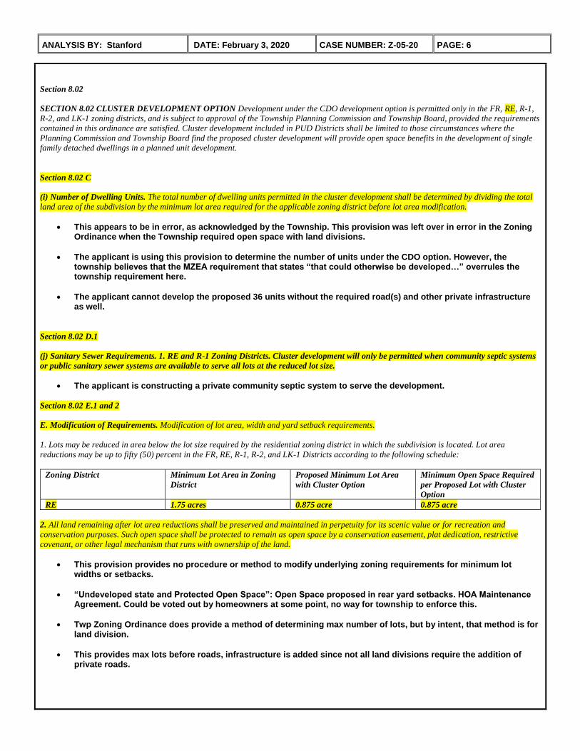
Section 8.02
SECTION 8.02 CLUSTER DEVELOPMENT OPTION Development under the CDO development option is permitted only in the FR, RE, R-1,
R-2, and LK-1 zoning districts, and is subject to approval of the Township Planning Commission and Township Board, provided the requirements
contained in this ordinance are satisfied. Cluster development included in PUD Districts shall be limited to those circumstances where the
Planning Commission and Township Board find the proposed cluster development will provide open space benefits in the development of single
family detached dwellings in a planned unit development.
Section 8.02 C
(i) Number of Dwelling Units. The total number of dwelling units permitted in the cluster development shall be determined by dividing the total
land area of the subdivision by the minimum lot area required for the applicable zoning district before lot area modification.
This appears to be in error, as acknowledged by the Township. This provision was left over in error in the Zoning Ordinance when the Township required open space with land divisions.
The applicant is using this provision to determine the number of units under the CDO option. However, the township believes that the MZEA requirement that states “that could otherwise be developed…” overrules the township requirement here.
The applicant cannot develop the proposed 36 units without the required road(s) and other private infrastructure as well.
Section 8.02 D.1
(j) Sanitary Sewer Requirements. 1. RE and R-1 Zoning Districts. Cluster development will only be permitted when community septic systems
or public sanitary sewer systems are available to serve all lots at the reduced lot size.
The applicant is constructing a private community septic system to serve the development.
Section 8.02 E.1 and 2
E. Modification of Requirements. Modification of lot area, width and yard setback requirements.
1. Lots may be reduced in area below the lot size required by the residential zoning district in which the subdivision is located. Lot area
reductions may be up to fifty (50) percent in the FR, RE, R-1, R-2, and LK-1 Districts according to the following schedule:
Zoning District Minimum Lot Area in Zoning
District
Proposed Minimum Lot Area
with Cluster Option
Minimum Open Space Required
per Proposed Lot with Cluster
Option
RE 1.75 acres 0.875 acre 0.875 acre
2. All land remaining after lot area reductions shall be preserved and maintained in perpetuity for its scenic value or for recreation and
conservation purposes. Such open space shall be protected to remain as open space by a conservation easement, plat dedication, restrictive
covenant, or other legal mechanism that runs with ownership of the land.
This provision provides no procedure or method to modify underlying zoning requirements for minimum lot widths or setbacks.
“Undeveloped state and Protected Open Space”: Open Space proposed in rear yard setbacks. HOA Maintenance Agreement. Could be voted out by homeowners at some point, no way for township to enforce this.
Twp Zoning Ordinance does provide a method of determining max number of lots, but by intent, that method is for land division.
This provides max lots before roads, infrastructure is added since not all land divisions require the addition of private roads.

ANALYSIS BY: Stanford DATE: February 3, 2020 CASE NUMBER: Z-05-20 PAGE: 7
Section 8.03
SECTION 8.03 OPEN SPACE PRESERVATION DESIGN STANDARDS Open space preservation areas shall be provided in compliance with
the provisions of Section 21.51. All open space areas preserved under these provisions must meet the requirements of the Michigan Zoning
Enabling Act, P.A. 110 of 2006, as amended. In particular, open space areas must be preserved in an undeveloped state as defined in the
Michigan Zoning Enabling Act, P.A. 110 of 2006, as amended, which excludes golf course development on open space preserved by these
provisions.
Section 21.51 OPEN SPACE DESIGN REQUIREMENTS
Sections B.1 and B.3
B. Exclusions. Open space shall not include:
1. Certain Easements. Areas devoted to public or private streets or the easement for shared driveway or private roads.
3. Yard Setbacks. Required yard setback areas as specified in Section 20.01
Section 21.51 C
C. Yard Setback Exceptions. The Planning Commission may allow specified areas located within the required yard setback or setbacks of an
individual parcel to be included as required open space, if the Commission finds that the protection of that open space area is consistent with the
intent of the open space concept.
Intent is one (1) Lot, not the entire 36 lot development
This is an Exception, not a Rule.
Insufficient Rear and Front setbacks and Minimum Lot widths proposed – doesn’t meet RE dimensional requirements.
Approximately 25% of lot area is proposed to be used as open space – doesn’t comply with MZEA intent. Also substantially reduces the proposed lot sizes to 0.75 acres (0.875 min in RE with OSP). See also Section 29.05.B.3 (Conditional Rezoning-Uses and Densities)
Section 21.51 D
D. Perimeter Open Space Measurement. If the Planning Commission allows required open space to be located within the yard perimeter, the
setback shall be measured from the closest point of the open space boundary.
It appears that this requirement is being ignored by the applicant.
If the Planning Commission were to allow the required rear yard to be included as open space, this land area clearly falls within the yard perimeter. Setbacks are then required to be measured from the open space boundary, so once again the building envelopes that are depicted on the proposed lots abut the open space boundary, therefore there is no rear yard setback, which does not comply with the lot dimensional requirements for RE
Section 21.51 F
Wetland Open Space. Not more than thirty-five (35) percent of the minimum open space area provided to satisfy the requirements of this
Ordinance shall be included in a wetland protected by the Natural Resources and Environmental Protection Act (PA 451 of 1994, as amended).
The applicant has not provided a wetland determination with EGLE’s acceptance. Any land area determined to be wetland would apply, reducing the land area available for use as open space.
The applicant has provided a 2005 preliminary wetland assessment which did identify regulated wetlands on the property, however, the document was dismissed by the Planning Commission due to:
The document being 15 years old; and
There is no formal endorsement from MDEQ or EGLE;
The township therefore requested/required an updated assessment along with endorsement from EGLE as a condition of acceptance.

ANALYSIS BY: Stanford DATE: February 3, 2020 CASE NUMBER: Z-05-20 PAGE: 8
Wetland areas within the proposed subject site should be professionally determined and endorsed through the State of Michigan Department EGLE.
Section 21.51 H
H. Relocation. Open space may be relocated if the Planning Commission and Township Board find that the original intent of the open space
requirement may be met at another location within the lot, parcel, or condominium unit.
This appears to be being applied incorrectly. First, this is at the discretion of the Planning Commission and Township Board, not the applicant’s. Second, this provision allows for open space within a lot/unit to be relocated within that same lot/unit. Nothing here states required open space for a development may be relocated to be within condominium lots/units.
Section 21.51 J
J. Maintenance Agreement. If open space is not dedicated to public use, it shall be protected by an open space maintenance agreement as
described herein. With regard to the privately owned open space, the open space maintenance agreement shall…:
HOA Maintenance Agreement. Is required and applicant indicates one will be put in place, However, the open space could be cleared out by homeowners at some point, no way for township to enforce this.
Section 29.05 CONDITIONAL REZONING
Section 29.05 B 3. Uses and Densities
2. Uses or Densities. The owner’s offer of conditions may not purport to authorize uses or densities not permitted in the requested new zoning
district.
Section 29.05.B.6 6. Deviation from Ordinance Standards. Any deviation from a Zoning Ordinance standard for the proposed zoning district
included as part of the conditional rezoning application shall be balanced by offsetting concession in the Statement of Conditions volunteered by
the applicant.
The applicant proposed the following offsetting concessions:
To conditionally rezone from FR to RE zoning (i.e., reduction of one zoning district density);
Lot sizes of 1 acre versus the minimum 0.875 allowed when applying CDO to lands rezoned RE (i.e., effectively through a second zoning district density reduction)
Side yard setbacks of 30 feet versus the required 20 feet in RE (i.e., develop the lots/units with reduced lot width and reduced front and rear yard setbacks which confirms a second zoning district density reduction, since the lots now comply more with R-1 Residential Zoning District developmental standards, not RE, Rural Estates)
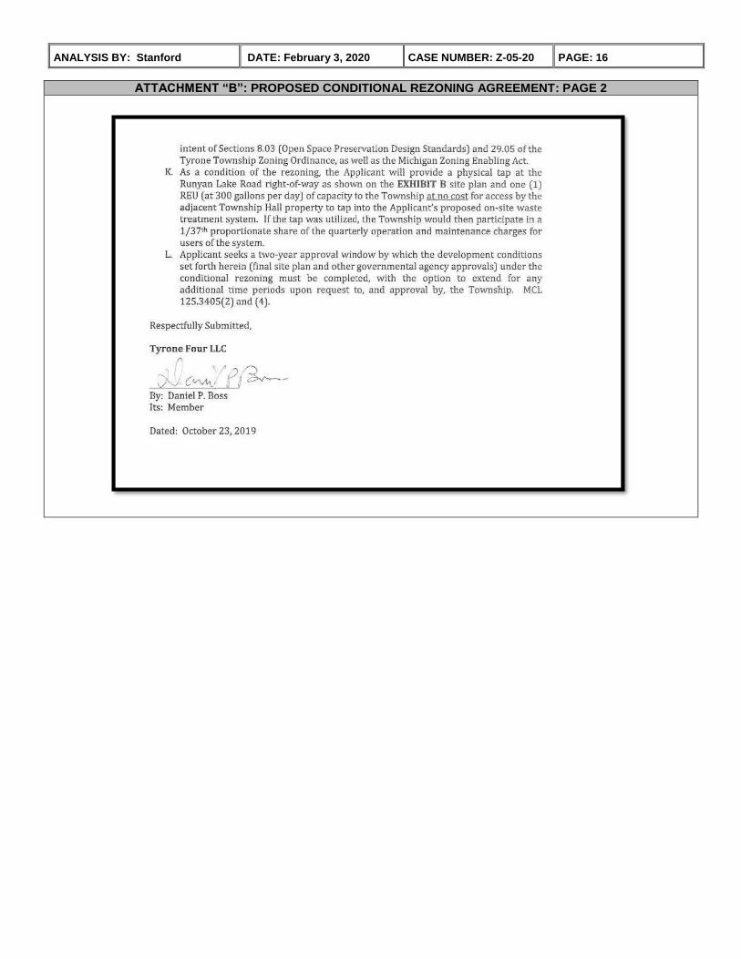
A physical tap at the Runyan Lake Road right of way and an offer of 1 REU for use of the Sanctuary at Tyrone community septic system at a quarterly O&M charge of 1/37th proportionate share. (Note: The offer of a physical tap is a consideration the Township Board must assess.)
The applicant is also proposing to use the entire required rear yard of all 36 units as open space, thereby reducing the developable, and usable lot area to 0.75 acre, which makes the lots quite similar to the Township’s R-2 Residential Zoning District developmental standards, which is their highest density single family residential district.
In essence the proposed development goes from the largest required lots to the smallest required lots in residential development.
The applicant is asking for the following deviations from developmental standards under RE zoning:
36 required rear yard setbacks used entirely for required open space;
36 rear yards without rear yards as a result of the prior bullet, because the building envelopes abut the open space;
36 rear yards with reduced rear yard setbacks prior to use as open space
36 front yards with reduced front yard setbacks. This is a conditional rezoning request. The intent here is that the applicant offer offsetting concessions for modifications to the requirements set forth for a typical rezoning to justify their specific use request.
ANALYSIS BY: Stanford DATE: February 3, 2020 CASE NUMBER: Z-05-20 PAGE: 9
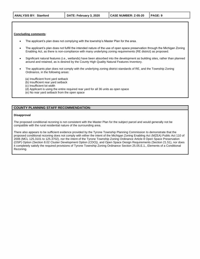
Concluding comments:
The applicant’s plan does not complying with the township’s Master Plan for the area.
The applicant’s plan does not fulfill the intended nature of the use of open space preservation through the Michigan Zoning Enabling Act, as there is non-compliance with many underlying zoning requirements (RE district) as proposed.
Significant natural features (i.e., wetlands) have been absorbed into the development as building sites, rather than planned around and retained, as is desired by the County High Quality Natural Features Inventory.
The applicants plan does not comply with the underlying zoning district standards of RE, and the Township Zoning Ordinance, in the following areas:
(a) Insufficient front yard setback (b) Insufficient rear yard setback (c) Insufficient lot width (d) Applicant is using the entire required rear yard for all 36 units as open space (e) No rear yard setback from the open space
COUNTY PLANNING STAFF RECOMMENDATION:
Disapproval
The proposed conditional rezoning is not consistent with the Master Plan for the subject parcel and would generally not be compatible with the rural residential nature of the surrounding area. There also appears to be sufficient evidence provided by the Tyrone Township Planning Commission to demonstrate that the proposed conditional rezoning does not comply with either the intent of the Michigan Zoning Enabling Act (MZEA) Public Act 110 of 2006 (MCL 125.3101 to 125.3702), nor the intent of the Tyrone Township Zoning Ordinance Article 8 Open Space Preservation (OSP) Option (Section 8.02 Cluster Development Option (CDO)), and Open Space Design Requirements (Section 21.51), nor does it completely satisfy the required provisions of Tyrone Township Zoning Ordinance Section 25.05.E.1., Elements of a Conditional Rezoning.

ANALYSIS BY: Stanford DATE: February 3, 2020 CASE NUMBER: Z-05-20 PAGE: 10
EXISTING LAND USE MAP:
FUTURE LAND USE MAP:

ANALYSIS BY: Stanford DATE: February 3, 2020 CASE NUMBER: Z-05-20 PAGE: 11
SURROUNDING ZONING MAP:
TOWNSHIP ZONING MAP:

ANALYSIS BY: Stanford DATE: February 3, 2020 CASE NUMBER: Z-05-20 PAGE: 12
SITE PHOTOS:
Subject Site
View Looking North from Site View Looking East from Site
View Looking South from Site View Looking West from Site

ANALYSIS BY: Stanford DATE: February 3, 2020 CASE NUMBER: Z-05-20 PAGE: 13
AERIAL PHOTO:
Oblique View: Looking East at Subject Parcel
N

ANALYSIS BY: Stanford DATE: February 3, 2020 CASE NUMBER: Z-05-20 PAGE: 14
ATTACHMENT “A”: PROPOSED OVERALL OPEN SPACE PLAN:

ANALYSIS BY: Stanford DATE: February 3, 2020 CASE NUMBER: Z-05-20 PAGE: 15
ATTACHMENT “B”: PROPOSED CONDITIONAL REZONING AGREEMENT: PAGE 1
ANALYSIS BY: Stanford DATE: February 3, 2020 CASE NUMBER: Z-05-20 PAGE: 16
ATTACHMENT “B”: PROPOSED CONDITIONAL REZONING AGREEMENT: PAGE 2


![PA Municipalities Planning Code - dep - Pennsylvania DEP1].pdf · Municipalities Planning Code Act of 1968, P ... or as may be designated in the law providing for the form ... “Common](https://img.pdfslide.us/doc/110x75/5aa8cb6c7f8b9a77188bfc40/pa-municipalities-planning-code-dep-pennsylvania-1pdfmunicipalities-planning.jpg)