Embed Size (px)
Citation preview
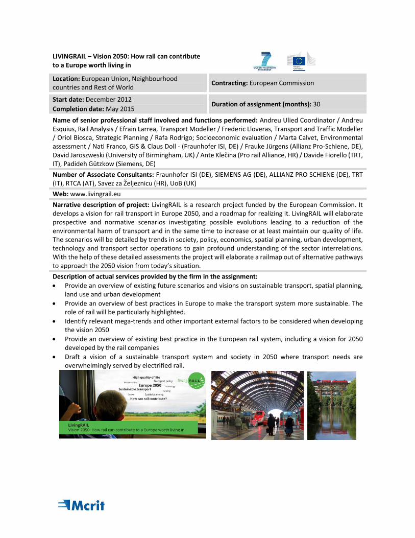
LIVINGRAIL – Vision 2050: How rail can contribute to a Europe worth living in
Location: European Union, Neighbourhood countries and Rest of World
Contracting: European Commission
Start date: December 2012
Completion date: May 2015 Duration of assignment (months): 30
Name of senior professional staff involved and functions performed: Andreu Ulied Coordinator / Andreu Esquius, Rail Analysis / Efrain Larrea, Transport Modeller / Frederic Lloveras, Transport and Traffic Modeller / Oriol Biosca, Strategic Planning / Rafa Rodrigo; Socioeconomic evaluation / Marta Calvet, Environmental assessment / Nati Franco, GIS & Claus Doll - (Fraunhofer ISI, DE) / Frauke Jürgens (Allianz Pro-Schiene, DE), David Jaroszweski (University of Birmingham, UK) / Ante Klečina (Pro rail Alliance, HR) / Davide Fiorello (TRT, IT), Padideh Gützkow (Siemens, DE)
Number of Associate Consultants: Fraunhofer ISI (DE), SIEMENS AG (DE), ALLIANZ PRO SCHIENE (DE), TRT (IT), RTCA (AT), Savez za Željeznicu (HR), UoB (UK)
Web: www.livingrail.eu
Narrative description of project: LivingRAIL is a research project funded by the European Commission. It develops a vision for rail transport in Europe 2050, and a roadmap for realizing it. LivingRAIL will elaborate prospective and normative scenarios investigating possible evolutions leading to a reduction of the environmental harm of transport and in the same time to increase or at least maintain our quality of life. The scenarios will be detailed by trends in society, policy, economics, spatial planning, urban development, technology and transport sector operations to gain profound understanding of the sector interrelations. With the help of these detailed assessments the project will elaborate a railmap out of alternative pathways to approach the 2050 vision from today’s situation.
Description of actual services provided by the firm in the assignment:
Provide an overview of existing future scenarios and visions on sustainable transport, spatial planning, land use and urban development
Provide an overview of best practices in Europe to make the transport system more sustainable. The role of rail will be particularly highlighted.
Identify relevant mega-trends and other important external factors to be considered when developing the vision 2050
Provide an overview of existing best practice in the European rail system, including a vision for 2050 developed by the rail companies
Draft a vision of a sustainable transport system and society in 2050 where transport needs are overwhelmingly served by electrified rail.
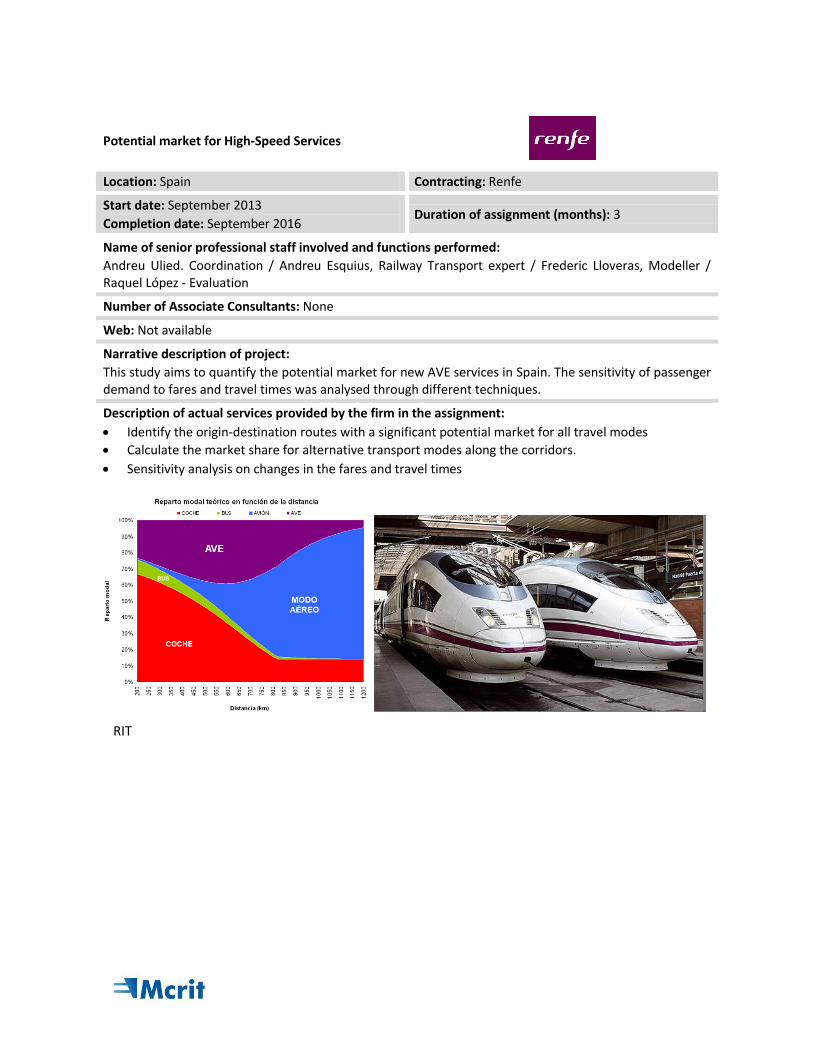
Potential market for High-Speed Services
Location: Spain Contracting: Renfe
Start date: September 2013
Completion date: September 2016 Duration of assignment (months): 3
Name of senior professional staff involved and functions performed:
Andreu Ulied. Coordination / Andreu Esquius, Railway Transport expert / Frederic Lloveras, Modeller / Raquel López - Evaluation
Number of Associate Consultants: None
Web: Not available
Narrative description of project:
This study aims to quantify the potential market for new AVE services in Spain. The sensitivity of passenger demand to fares and travel times was analysed through different techniques.
Description of actual services provided by the firm in the assignment:
Identify the origin-destination routes with a significant potential market for all travel modes
Calculate the market share for alternative transport modes along the corridors.
Sensitivity analysis on changes in the fares and travel times
RIT
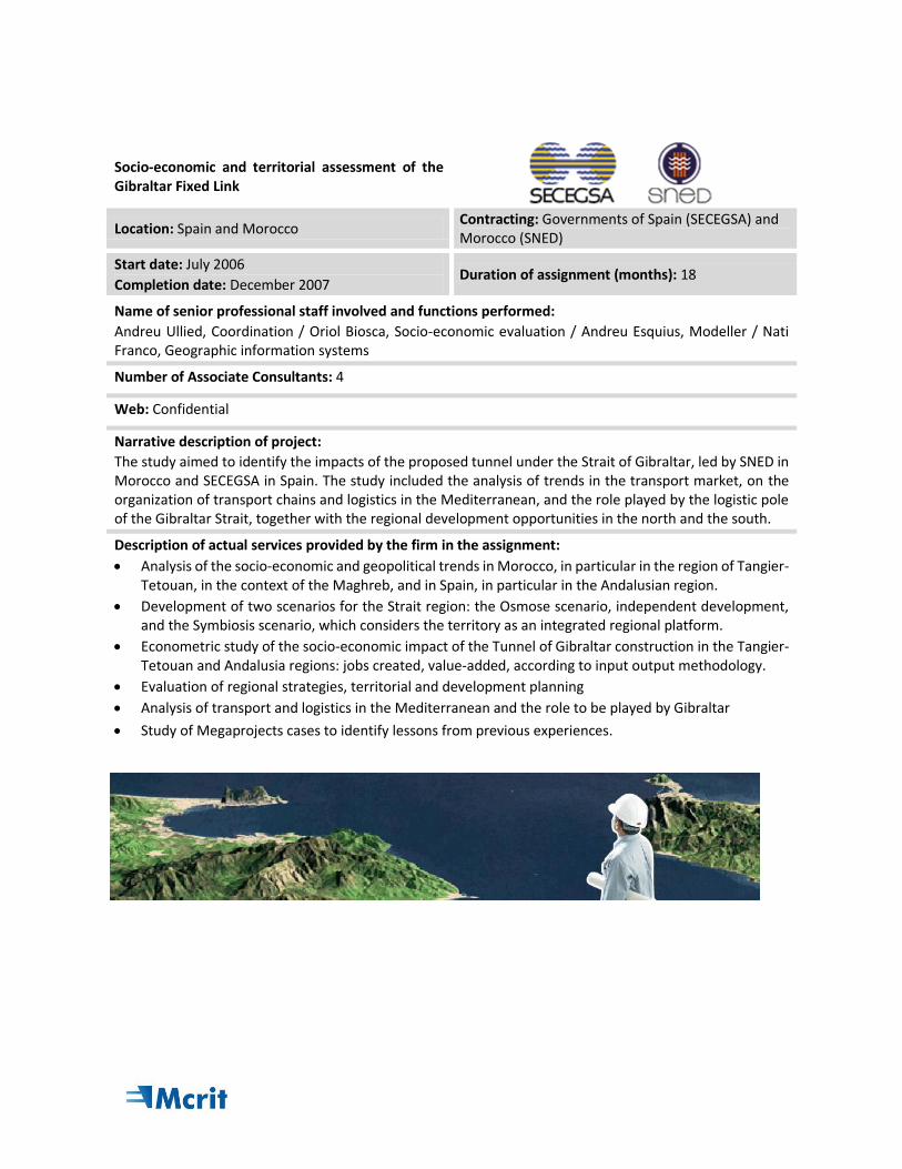
Socio-economic and territorial assessment of the Gibraltar Fixed Link
Location: Spain and Morocco Contracting: Governments of Spain (SECEGSA) and Morocco (SNED)
Start date: July 2006
Completion date: December 2007 Duration of assignment (months): 18
Name of senior professional staff involved and functions performed:
Andreu Ullied, Coordination / Oriol Biosca, Socio-economic evaluation / Andreu Esquius, Modeller / Nati Franco, Geographic information systems
Number of Associate Consultants: 4
Web: Confidential
Narrative description of project:
The study aimed to identify the impacts of the proposed tunnel under the Strait of Gibraltar, led by SNED in Morocco and SECEGSA in Spain. The study included the analysis of trends in the transport market, on the organization of transport chains and logistics in the Mediterranean, and the role played by the logistic pole of the Gibraltar Strait, together with the regional development opportunities in the north and the south.
Description of actual services provided by the firm in the assignment:
Analysis of the socio-economic and geopolitical trends in Morocco, in particular in the region of Tangier-Tetouan, in the context of the Maghreb, and in Spain, in particular in the Andalusian region.
Development of two scenarios for the Strait region: the Osmose scenario, independent development, and the Symbiosis scenario, which considers the territory as an integrated regional platform.
Econometric study of the socio-economic impact of the Tunnel of Gibraltar construction in the Tangier-Tetouan and Andalusia regions: jobs created, value-added, according to input output methodology.
Evaluation of regional strategies, territorial and development planning
Analysis of transport and logistics in the Mediterranean and the role to be played by Gibraltar
Study of Megaprojects cases to identify lessons from previous experiences.
TENCONNECT: Revision of European Transport Networks
Location: European Union and Neighbourhood countries
Contracting: European Commission / DG TREN
Start date: September 2007
Completion date: November 2009 Duration of assignment (months): 25
Name of senior professional staff involved and functions performed: Andreu Ulied, Director / Andreu Esquius, Coordination / Efraín Larrea, Modeller / Oriol Biosca, Planning / Rafa Rodrigo; Socio-economic assessment / Nati Franco, GIS
Number of Associate Consultants:
Web: Not available
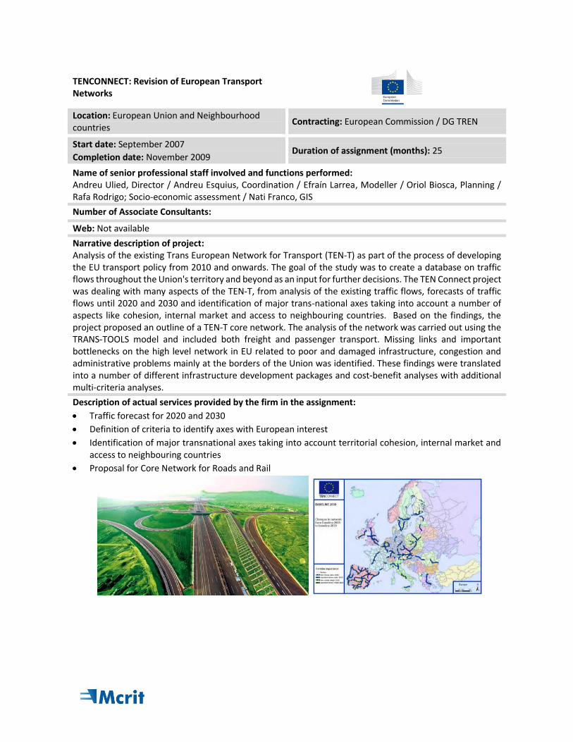
Narrative description of project: Analysis of the existing Trans European Network for Transport (TEN-T) as part of the process of developing the EU transport policy from 2010 and onwards. The goal of the study was to create a database on traffic flows throughout the Union's territory and beyond as an input for further decisions. The TEN Connect project was dealing with many aspects of the TEN-T, from analysis of the existing traffic flows, forecasts of traffic flows until 2020 and 2030 and identification of major trans-national axes taking into account a number of aspects like cohesion, internal market and access to neighbouring countries. Based on the findings, the project proposed an outline of a TEN-T core network. The analysis of the network was carried out using the TRANS-TOOLS model and included both freight and passenger transport. Missing links and important bottlenecks on the high level network in EU related to poor and damaged infrastructure, congestion and administrative problems mainly at the borders of the Union was identified. These findings were translated into a number of different infrastructure development packages and cost-benefit analyses with additional multi-criteria analyses.
Description of actual services provided by the firm in the assignment:
Traffic forecast for 2020 and 2030
Definition of criteria to identify axes with European interest
Identification of major transnational axes taking into account territorial cohesion, internal market and access to neighbouring countries
Proposal for Core Network for Roads and Rail
TRANSvisions - Report on Transport Scenarios with a 20 and 40 Year Horizon
Location: Global, European Union and Neighbourhood countries
Contracting: European Commission / DG TREN
Start date: January 2008
Completion date: May 2009 Duration of assignment (months): 17
Name of senior professional staff involved and functions performed: Andreu Ulied, Director / Andreu Esquius, Coordination / Efraín Larrea, Modeller / Oriol Biosca, Planning / Rafa Rodrigo; Socio-economic assessment / Nati Franco, GIS
Number of Associate Consultants: 6
Web: Not available
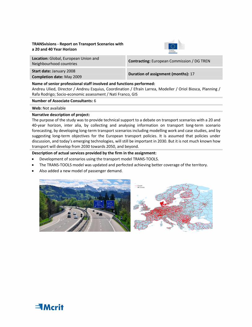
Narrative description of project: The purpose of the study was to provide technical support to a debate on transport scenarios with a 20 and 40-year horizon, inter alia, by collecting and analysing information on transport long-term scenario forecasting, by developing long-term transport scenarios including modelling work and case studies, and by suggesting long-term objectives for the European transport policies. It is assumed that policies under discussion, and today’s emerging technologies, will still be important in 2030. But it is not much known how transport will develop from 2030 towards 2050, and beyond.
Description of actual services provided by the firm in the assignment:
Development of scenarios using the transport model TRANS-TOOLS.
The TRANS-TOOLS model was updated and perfected achieving better coverage of the territory.
Also added a new model of passenger demand.
DESTIN - Defining and Evaluating a Strategic Transport Infrastructure Network in the Western Mediterranean
Location: Maghreb countries Contracting: CETMO Foundation / Fifth Framework Programme
Start date: February 2003
Completion date: October 2005 Duration of assignment (months): 32
Name of senior professional staff involved and functions performed:
Andreu Ullied, Coordination / Andreu Esquius, Analysis / Efrain Larrea, Modeller Nati Franco, GIS
Number of Associate Consultants: CETMO (SP), NESTEAR (FR), IRAT (IT), SNED (MOR), ETIC (TN), KHAN Consultants (ALG)
Web: www.mcrit.com/Destin/
Narrative description of project:
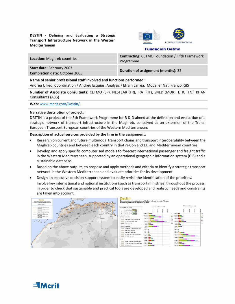
DESTIN is a project of the 5th Framework Programme for R & D aimed at the definition and evaluation of a strategic network of transport infrastructure in the Maghreb, conceived as an extension of the Trans-European Transport European countries of the Western Mediterranean.
Description of actual services provided by the firm in the assignment:
Research on current and future multimodal transport chains and transport interoperability between the Maghreb countries and between each country in that region and EU and Mediterranean countries.
Develop and apply specific computerised models to forecast international passenger and freight traffic in the Western Mediterranean, supported by an operational geographic information system (GIS) and a sustainable database.
Based on the above outputs, to propose and apply methods and criteria to identify a strategic transport network in the Western Mediterranean and evaluate priorities for its development
Design an executive decision-support system to easily revise the identification of the priorities.
Involve key international and national institutions (such as transport ministries) throughout the process, in order to check that sustainable and practical tools are developed and realistic needs and constraints are taken into account.
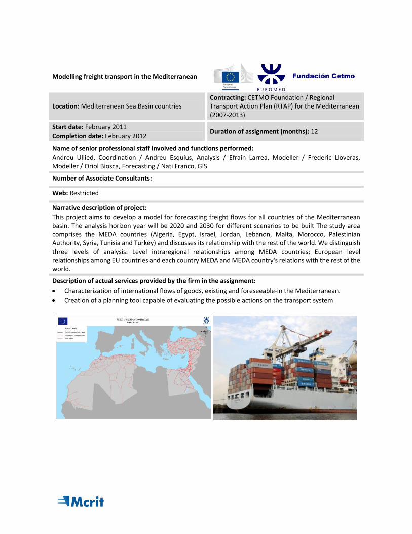
Modelling freight transport in the Mediterranean
Location: Mediterranean Sea Basin countries Contracting: CETMO Foundation / Regional Transport Action Plan (RTAP) for the Mediterranean (2007-2013)
Start date: February 2011
Completion date: February 2012 Duration of assignment (months): 12
Name of senior professional staff involved and functions performed:
Andreu Ullied, Coordination / Andreu Esquius, Analysis / Efrain Larrea, Modeller / Frederic Lloveras, Modeller / Oriol Biosca, Forecasting / Nati Franco, GIS
Number of Associate Consultants:
Web: Restricted
Narrative description of project:
This project aims to develop a model for forecasting freight flows for all countries of the Mediterranean basin. The analysis horizon year will be 2020 and 2030 for different scenarios to be built The study area comprises the MEDA countries (Algeria, Egypt, Israel, Jordan, Lebanon, Malta, Morocco, Palestinian Authority, Syria, Tunisia and Turkey) and discusses its relationship with the rest of the world. We distinguish three levels of analysis: Level intraregional relationships among MEDA countries; European level relationships among EU countries and each country MEDA and MEDA country's relations with the rest of the world.
Description of actual services provided by the firm in the assignment:
Characterization of international flows of goods, existing and foreseeable-in the Mediterranean.
Creation of a planning tool capable of evaluating the possible actions on the transport system
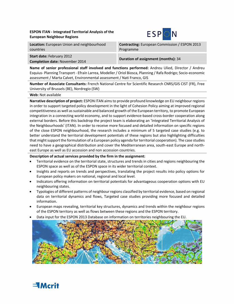
ESPON ITAN - Integrated Territorial Analysis of the European Neighbour Regions
Location: European Union and neighbourhood countries
Contracting: European Commission / ESPON 2013 Programme
Start date: February 2012
Completion date: November 2014 Duration of assignment (months): 34
Name of senior professional staff involved and functions performed: Andreu Ulied, Director / Andreu Esquius- Planning Transport - Efraín Larrea, Modeller / Oriol Biosca, Planning / Rafa Rodrigo; Socio-economic assessment / Marta Calvet, Environmental assessment / Nati Franco, GIS
Number of Associate Consultants: French National Centre for Scientific Research CNRS/GIS CIST (FR), Free University of Brussels (BE), Nordregio (SW)
Web: Not available
Narrative description of project: ESPON ITAN aims to provide profound knowledge on EU neighbour regions in order to support targeted policy development in the light of Cohesion Policy aiming at improved regional competitiveness as well as sustainable and balanced growth of the European territory, to promote European integration in a connecting world economy, and to support evidence-based cross-border cooperation along external borders. Before this backdrop the project team is elaborating an ‘Integrated Territorial Analysis of the Neighbourhoods’ (ITAN). In order to receive more focused and detailed information on specific regions of the close ESPON neighbourhood, the research includes a minimum of 5 targeted case studies (e.g. to better understand the territorial development potentials of these regions but also highlighting difficulties that might support the formulation of a European policy agenda for territorial cooperation). The case studies need to have a geographical distribution and cover the Mediterranean area, south-east Europe and north-east Europe as well as EU accession and non accession countries.
Description of actual services provided by the firm in the assignment:
Territorial evidence on the territorial state, structures and trends in cities and regions neighbouring the ESPON space as well as of the ESPON space in its wider territorial context.
Insights and reports on trends and perspectives, translating the project results into policy options for European policy makers on national, regional and local level.
Indicators offering information on territorial potentials for advantageous cooperation options with EU neighbouring states.
Typologies of different patterns of neighbour regions classified by territorial evidence, based on regional data on territorial dynamics and flows, Targeted case studies providing more focused and detailed information.
European maps revealing, territorial key structures, dynamics and trends within the neighbour regions of the ESPON territory as well as flows between these regions and the ESPON territory.
Data input for the ESPON 2013 Database on information on territories neighbouring the EU.
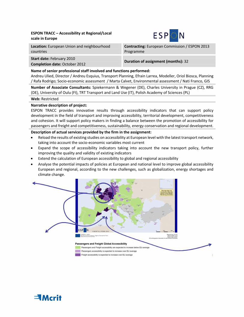
ESPON TRACC – Accessibility at Regional/Local scale in Europe
Location: European Union and neighbourhood countries
Contracting: European Commission / ESPON 2013 Programme
Start date: February 2010
Completion date: October 2012 Duration of assignment (months): 32
Name of senior professional staff involved and functions performed: Andreu Ulied, Director / Andreu Esquius, Transport Planning, Efrain Larrea, Modeller, Oriol Biosca, Planning / Rafa Rodrigo; Socio-economic assessment / Marta Calvet, Environmental assessment / Nati Franco, GIS
Number of Associate Consultants: Spiekermann & Wegener (DE), Charles University in Prague (CZ), RRG (DE), University of Oulu (FI), TRT Transport and Land Use (IT), Polish Academy of Sciences (PL)
Web: Restricted
Narrative description of project: ESPON TRACC provides innovative results through accessibility indicators that can support policy development in the field of transport and improving accessibility, territorial development, competitiveness and cohesion. It will support policy makers in finding a balance between the promotion of accessibility for passengers and freight and competitiveness, sustainability, energy conservation and regional development.
Description of actual services provided by the firm in the assignment:
Reload the results of existing studies on accessibility at European level with the latest transport network, taking into account the socio-economic variables most current
Expand the scope of accessibility indicators taking into account the new transport policy, further improving the quality and validity of existing indicators
Extend the calculation of European accessibility to global and regional accessibility
Analyse the potential impacts of policies at European and national level to improve global accessibility European and regional, according to the new challenges, such as globalization, energy shortages and climate change.
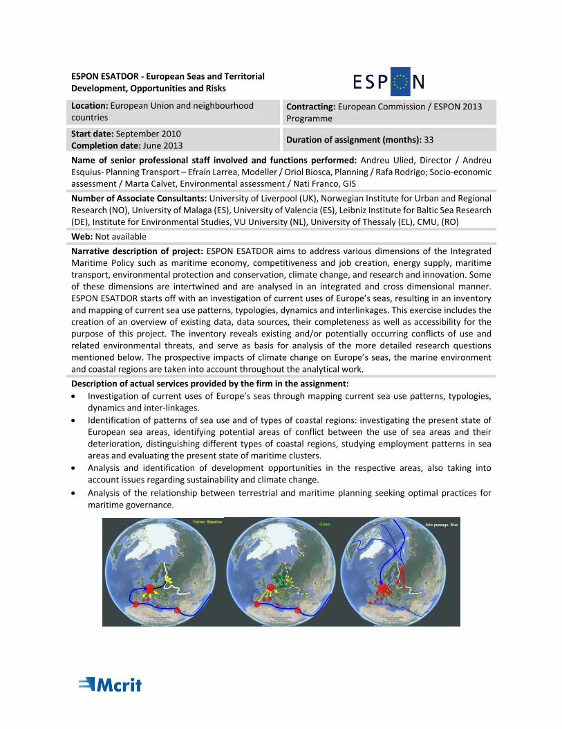
ESPON ESATDOR - European Seas and Territorial Development, Opportunities and Risks
Location: European Union and neighbourhood countries
Contracting: European Commission / ESPON 2013 Programme
Start date: September 2010 Completion date: June 2013
Duration of assignment (months): 33
Name of senior professional staff involved and functions performed: Andreu Ulied, Director / Andreu Esquius- Planning Transport – Efraín Larrea, Modeller / Oriol Biosca, Planning / Rafa Rodrigo; Socio-economic assessment / Marta Calvet, Environmental assessment / Nati Franco, GIS
Number of Associate Consultants: University of Liverpool (UK), Norwegian Institute for Urban and Regional Research (NO), University of Malaga (ES), University of Valencia (ES), Leibniz Institute for Baltic Sea Research (DE), Institute for Environmental Studies, VU University (NL), University of Thessaly (EL), CMU, (RO)
Web: Not available
Narrative description of project: ESPON ESATDOR aims to address various dimensions of the Integrated Maritime Policy such as maritime economy, competitiveness and job creation, energy supply, maritime transport, environmental protection and conservation, climate change, and research and innovation. Some of these dimensions are intertwined and are analysed in an integrated and cross dimensional manner. ESPON ESATDOR starts off with an investigation of current uses of Europe’s seas, resulting in an inventory and mapping of current sea use patterns, typologies, dynamics and interlinkages. This exercise includes the creation of an overview of existing data, data sources, their completeness as well as accessibility for the purpose of this project. The inventory reveals existing and/or potentially occurring conflicts of use and related environmental threats, and serve as basis for analysis of the more detailed research questions mentioned below. The prospective impacts of climate change on Europe’s seas, the marine environment and coastal regions are taken into account throughout the analytical work.
Description of actual services provided by the firm in the assignment:
Investigation of current uses of Europe’s seas through mapping current sea use patterns, typologies, dynamics and inter-linkages.
Identification of patterns of sea use and of types of coastal regions: investigating the present state of European sea areas, identifying potential areas of conflict between the use of sea areas and their deterioration, distinguishing different types of coastal regions, studying employment patterns in sea areas and evaluating the present state of maritime clusters.
Analysis and identification of development opportunities in the respective areas, also taking into account issues regarding sustainability and climate change.
Analysis of the relationship between terrestrial and maritime planning seeking optimal practices for maritime governance.
ESPON ET2050 –Territorial Scenarios and Visions for Europe
Location: European Union and neighbourhood countries
Contracting: European Commission / ESPON 2013 Programme
Start date: June 2011
Completion date: December 2014 Duration of assignment (months): 35
Name of senior professional staff involved and functions performed: Andreu Ulied, Director / Andreu Esquius, Analysis / Efraín Larrea, Modeller / Oriol Biosca, Planning / Rafa Rodrigo; Socio-economic assessment / Marta Calvet, Environmental assessment / Nati Franco, GIS
Number of Associate Consultants: Tersyn (FR), Igeat ULB (BE), RKK – MTA (HU), POLIMI (IT) ,International Organization for Migration- IOM (PL), S&W (DE), RIKS, Warsaw School of Economics (PL), NORDREGIO (SW), University of Thessaly (EL), ISIS (IT), Fundación Ersilia (ES)
Web: www.et2050.eu/
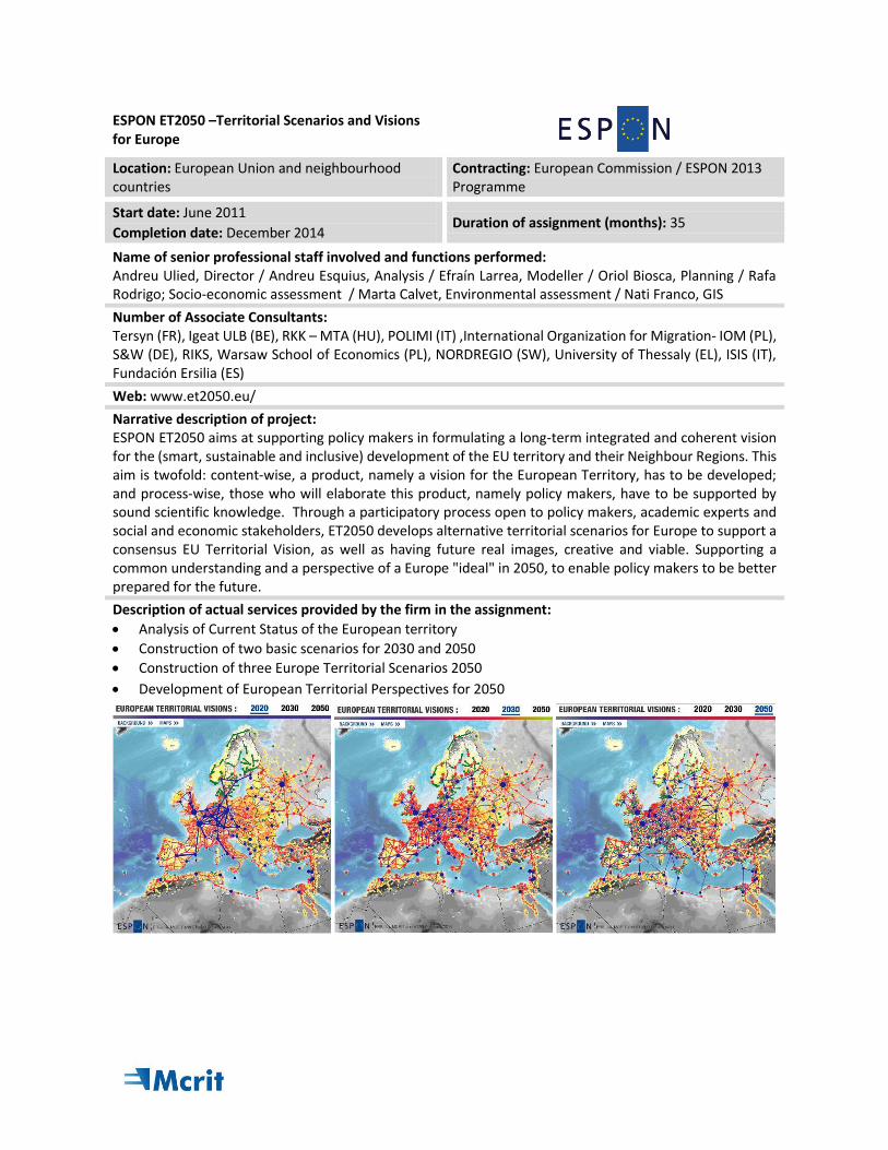
Narrative description of project: ESPON ET2050 aims at supporting policy makers in formulating a long-term integrated and coherent vision for the (smart, sustainable and inclusive) development of the EU territory and their Neighbour Regions. This aim is twofold: content-wise, a product, namely a vision for the European Territory, has to be developed; and process-wise, those who will elaborate this product, namely policy makers, have to be supported by sound scientific knowledge. Through a participatory process open to policy makers, academic experts and social and economic stakeholders, ET2050 develops alternative territorial scenarios for Europe to support a consensus EU Territorial Vision, as well as having future real images, creative and viable. Supporting a common understanding and a perspective of a Europe "ideal" in 2050, to enable policy makers to be better prepared for the future.
Description of actual services provided by the firm in the assignment:
Analysis of Current Status of the European territory
Construction of two basic scenarios for 2030 and 2050
Construction of three Europe Territorial Scenarios 2050
Development of European Territorial Perspectives for 2050
INTERCONNECT – Interconnection between transport network short and long distance
Location: European Union and Neighbourhood countries
Contracting: European Commission
Start date: June 2009
Completion date: May 2011 Duration of assignment (months): 27
Name of senior professional staff involved and functions performed:
Andreu Ulied, Director / Andreu Esquius, Analysis / Efraín Larrea, Modeller / Oriol Biosca, Forecasting / Rafa Rodrigo; Socio-economic evaluation / Marta Calvet, Environmental impact assessment / Nati Franco, GIS
Number of Associate Consultants: University of Napier (UK) (Coordinator)
Web: https://cordis.europa.eu/project/rcn/91152_en.html
Narrative description of project:
The INTERCONNECT project is co-funded by the European Commission within the Seventh Framework Programme, Theme 7 Transport. INTERCONNECT is examining the role of local and regional interconnections in the context of longer distance passenger journeys in Europe, in order to address the potential for greater economic efficiency and reduced environmental impact. Factors investigated in the project include integration, co-operation and, where appropriate, competition in the provision of local connections across all transport modes. The methodology that has been employed in the project includes literature reviews, interviews with key stakeholders and detailed investigations of selected case studies. INTERCONNECT addresses the potential for greater efficiency and reduced environmental impact of passenger transport through encouragement of integration, co-operation and, where appropriate, competition in the provision of these local and regional connections.
Description of actual services provided by the firm in the assignment:
Analysis of the role that EU and national policies currently play in improving interconnectivity, as well as exploring the potential role these and other policies could play.
Identified potential solutions from literature and defined a first set of case studies in order to examine the mechanisms for improving interconnectivity between the different network scales (local and regional) and between road, rail, maritime and air passenger modes of transport.
In-depth analysis of potential solutions through a second set of case studies, or "test beds" to identify the benefits of particular identified solutions and any possible barriers to their implementation.
ORIGAMI - Optimal regulation and infrastructure for ground, air and maritime interfaces
Location: European Union and neighbourhood countries
Contracting: European Commission / FP7
Start date: November 2011
Completion date: January 2014 Duration of assignment (months): 27
Name of senior professional staff involved and functions performed: Andreu Ulied, Director / Andreu Esquius, Modeller / Efraín Larrea, Modeller / Oriol Biosca, Modeller / Rafa Rodrigo; Socio-economic evaluation / Marta Calvet, Environmental impact assessment / Nati Franco, Geographic information systems
Number of Associate Consultants: MKmetric Gesellschaft für Systemplanung (DE),ISIS (IT), University of Leeds (UK), TEchnische Universitaet Wien TUW (AU), Uniwersytet Gdanski )(PL)
Web: www.origami-project.eu
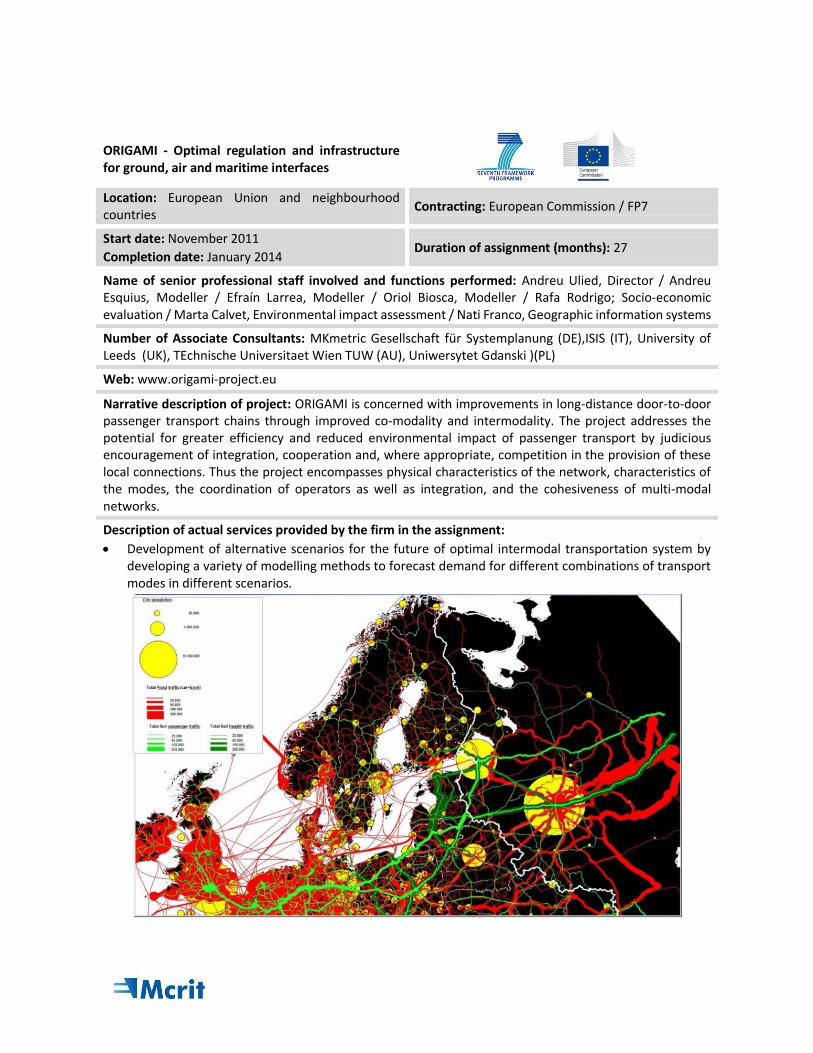
Narrative description of project: ORIGAMI is concerned with improvements in long-distance door-to-door passenger transport chains through improved co-modality and intermodality. The project addresses the potential for greater efficiency and reduced environmental impact of passenger transport by judicious encouragement of integration, cooperation and, where appropriate, competition in the provision of these local connections. Thus the project encompasses physical characteristics of the network, characteristics of the modes, the coordination of operators as well as integration, and the cohesiveness of multi-modal networks.
Description of actual services provided by the firm in the assignment:
Development of alternative scenarios for the future of optimal intermodal transportation system by developing a variety of modelling methods to forecast demand for different combinations of transport modes in different scenarios.
COMPASS - Optimised co-modal passenger transport for reducing carbon emissions
Location: European Union Contracting: European Commission / FP7
Start date: November 2011
Completion date: November 2013 Duration of assignment (months): 25
Name of senior professional staff involved and functions performed:
Andreu Ulied, Director / Andreu Esquius, Coordination / Efraín Larrea, Modeller / Oriol Biosca, Planning / Rafa Rodrigo; Socio-economic assessment / Marta Calvet, Environmental assessment / Nati Franco, GIS
Number of Associate Consultants: Napier University (UK), Instituto di Studi per l'integrazione dei Sistemi (IT), University of Leeds (UK), Mkmetric Gesellschaft Für Systemplanung (D),TRT Trasporti e territorio (IT), TTS Italia (IT), Technische Universitätwien Tuw (AU),Uniwersytet Gdanski (PL)
Web: http://www.fp7-compass.eu/
Narrative description of project:
COMPASS explored how ICT (information and computer technology) and ITS (intelligent transport systems) applications can meet the future demands identified, favouring the integration of multi-modal transport solutions, and will assess how these solutions can contribute to the de-carbonisation of transport activities. In COMPASS co-modality is defined as "using the transport system so that a particular mode is used when it is the most appropriate one for a particular journey; this can involve intermodal trips, but may also involve single-mode trips”.
Description of actual services provided by the firm in the assignment:
Solutions for optimised co-modality are identified and assessed, so that policy recommendations can be made.
Development of a transport forecast model to identify the major trends affecting the mobility of passengers in the present and future scenarios in Europe
Design, development and implementation HIGH-TOOL Strategic high - level transport assessment model
Location: Global, European Union and Neighbourhood countries
Contracting: European Commission
Start date: April 2013
Completion date: July 2016 Duration of assignment (months): 34
Name of senior professional staff involved and functions performed: Andreu Ulied, Director / Andreu Esquius, Modeller / Efraín Larrea, Modeller / Oriol Biosca, Modeller / Nati Franco, GIS
Number of Associate Consultants: KIT (GE), TNO (NE),MKmetric (GE), Panteia (NE), TML (BE), SIG (NE), FOMTERV IN (HU)
Web: www.high-tool.eu
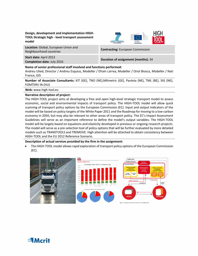
Narrative description of project: The HIGH-TOOL project aims at developing a free and open high-level strategic transport model to assess economic, social and environmental impacts of transport policy. The HIGH-TOOL model will allow quick scanning of transport policy options by the European Commission (EC). Input and output indicators of the model will be based on policy targets of the White Paper 2011 and the Roadmap for moving to a low-carbon economy in 2050, but may also be relevant to other areas of transport policy. The EC’s Impact Assessment Guidelines will serve as an important reference to define the model’s output variables. The HIGH-TOOL model will be largely based on equations and elasticity developed in previous or ongoing research projects. The model will serve as a pre-selection tool of policy options that will be further evaluated by more detailed models such as TRANSTOOLS and TREMOVE. High attention will be attached to obtain consistency between HIGH-TOOL and the EU 2012 Reference Scenario.
Description of actual services provided by the firm in the assignment:
The HIGH-TOOL model allows rapid exploration of transport policy options of the European Commission (EC).
FLAGSHIP – Forward Looking Analysis of Grand Societal cHallenges and Innovative Policies Location: European Union and neighbourhood countries
Contracting: European Commission / FP7
Start date: January 2013 Completion date: December 2015
Duration of assignment (months): 36
Name of senior professional staff involved and functions performed: Andreu Ulied, Director / Andreu Esquius- Transport - Efraín Larrea, Modeller / Oriol Biosca, Foresight / Rafa Rodrigo; Socio-economic assessment / Judith Requena – Climate Change / Berta Carreras- Benchmarking / Nati Franco, GIS
Number of Associate Consultants: ISIS (Italy), OEAW-VID (Austria), BC3 (Spain), SIGMA (France), CEPS (Belgium), HiiL (The Netherlands), CDS (Bulgaria), ICS-UL (Portugal), KNAW-NIDI (The Netherlands), OME (France), S4S (Luxembourg), SEIT (Estonia), SEURECO (France), SAN (Poland), TNO (The Netherlands)
Web: http://flagship-project.eu/
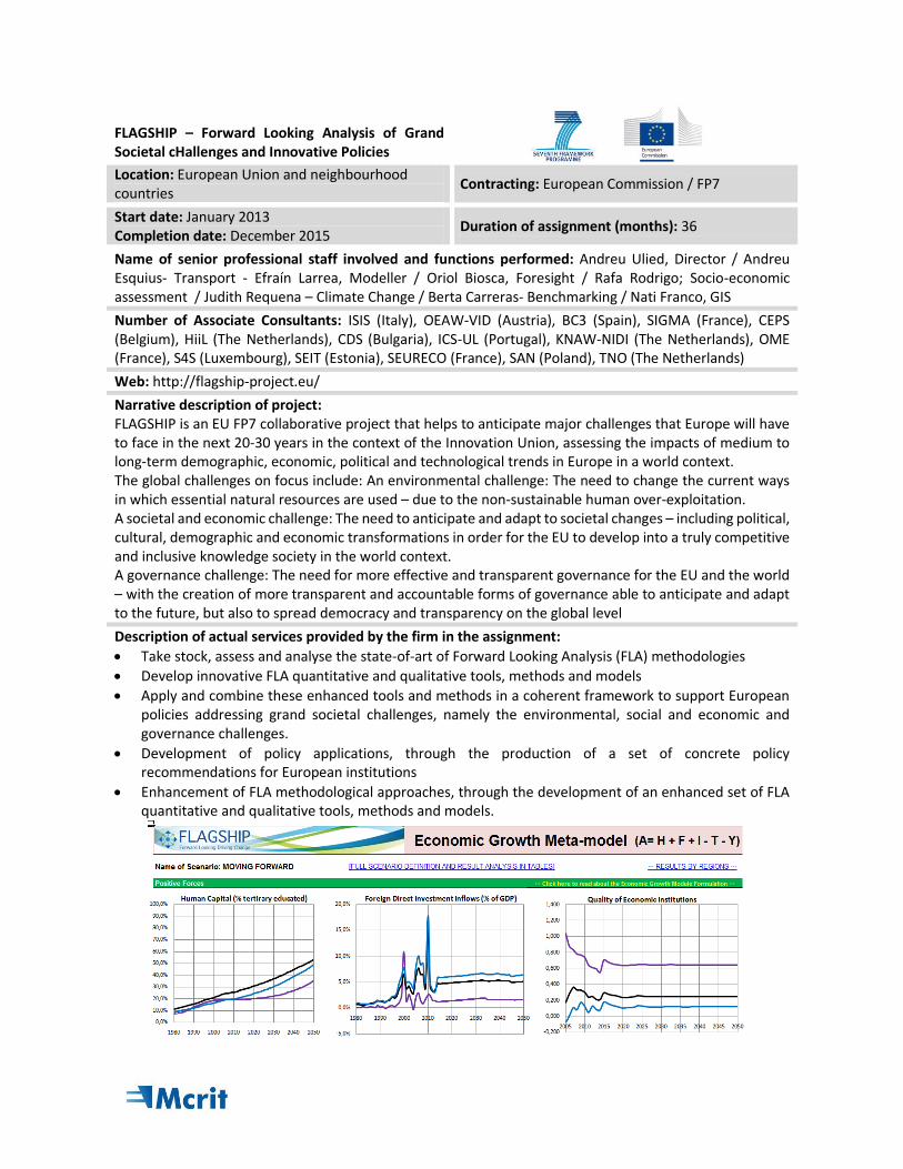
Narrative description of project: FLAGSHIP is an EU FP7 collaborative project that helps to anticipate major challenges that Europe will have to face in the next 20-30 years in the context of the Innovation Union, assessing the impacts of medium to long-term demographic, economic, political and technological trends in Europe in a world context. The global challenges on focus include: An environmental challenge: The need to change the current ways in which essential natural resources are used – due to the non-sustainable human over-exploitation. A societal and economic challenge: The need to anticipate and adapt to societal changes – including political, cultural, demographic and economic transformations in order for the EU to develop into a truly competitive and inclusive knowledge society in the world context. A governance challenge: The need for more effective and transparent governance for the EU and the world – with the creation of more transparent and accountable forms of governance able to anticipate and adapt to the future, but also to spread democracy and transparency on the global level
Description of actual services provided by the firm in the assignment:
Take stock, assess and analyse the state-of-art of Forward Looking Analysis (FLA) methodologies
Develop innovative FLA quantitative and qualitative tools, methods and models
Apply and combine these enhanced tools and methods in a coherent framework to support European policies addressing grand societal challenges, namely the environmental, social and economic and governance challenges.
Development of policy applications, through the production of a set of concrete policy recommendations for European institutions
Enhancement of FLA methodological approaches, through the development of an enhanced set of FLA quantitative and qualitative tools, methods and models.
PASHMINA – Paradigm shifts modelling and innovate approaches Location: European Union and neighbourhood countries
Contracting: European Commission / FP7
Start date: November 2009 Completion date: October 2012
Duration of assignment (months): 36
Name of senior professional staff involved and functions performed: Andreu Ulied, Director / Andreu Esquius- Transport - Efraín Larrea, Modeller / Oriol Biosca, Foresight / Rafa Rodrigo; Socio-economic assessment / Judith Requena – Climate Change / Nati Franco, GIS
Number of Associate Consultants: ISIS (Italy), WIFO (AT), CUNI (CZ), CSIC (ES), Enerdata (FR), Fondazione Eni Enrico Mattei (IT), IfW (DE), IIASA (AT), SMASH (FR), NERI (DK)
Web: www.pashmina-project.eu/
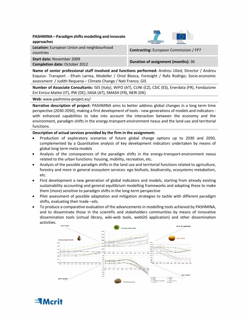
Narrative description of project: PASHMINA aims to better address global changes in a long term time perspective (2030-2050), making a first development of tools - new generations of models and indicators - with enhanced capabilities to take into account the interaction between the economy and the environment, paradigm shifts in the energy-transport-environment nexus and the land-use and territorial functions.
Description of actual services provided by the firm in the assignment:
Production of exploratory scenarios of future global change options up to 2030 and 2050, complemented by a Quantitative analysis of key development indicators undertaken by means of global long term meta-models
Analysis of the consequences of the paradigm shifts in the energy-transport-environment nexus related to the urban functions: housing, mobility, recreation, etc.
Analysis of the possible paradigm shifts in the land use and territorial functions related to agriculture, forestry and more in general ecosystem services: ego biofuels, biodiversity, ecosystems metabolism, etc.
First development a new generation of global indicators and models, starting from already existing sustainability accounting and general equilibrium modelling frameworks and adapting these to make them (more) sensitive to paradigm shifts in the long-term perspective
Pilot assessment of possible adaptation and mitigation strategies to tackle with different paradigm shifts, evaluating their trade –oils.
To produce a comparative evaluation of the advancements in modelling tools achieved by PASHMINA, and to disseminate those in the scientific and stakeholders communities by means of innovative dissemination tools (virtual library, wiki-web tools, webGIS application) and other dissemination activities.
IGIS - System for evaluation of infrastructure projects
Location: Europe and Neighbourhood Countries Contracting: European Investment Bank
Start date: June 2004
Completion date: December 2006 Duration of assignment (months): 30
Name of senior professional staff involved and functions performed:
Andreu Ullied, Coordination, Efraín Larrea, Modeller, Nati Franco, Geographic information systems
Number of Associate Consultants: None
Web: Not available
Narrative description of project:
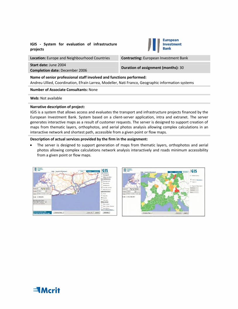
IGIS is a system that allows access and evaluates the transport and infrastructure projects financed by the European Investment Bank. System based on a client-server application, intra and extranet. The server generates interactive maps as a result of customer requests. The server is designed to support creation of maps from thematic layers, orthophotos, and aerial photos analysis allowing complex calculations in an interactive network and shortest path, accessible from a given point or flow maps.
Description of actual services provided by the firm in the assignment:
The server is designed to support generation of maps from thematic layers, orthophotos and aerial photos allowing complex calculations network analysis interactively and roads minimum accessibility from a given point or flow maps.
Assessment impact of the infrastructure constraints on Railway Undertakings operations
Location: France, Spain, Portugal and Germany Contracting: European Economic Interest Group «EEIG CFM4» / European Union (Trans-European Transport Network)
Start date: December 2014
Completion date: June 2015 Duration of assignment (months): 6
Name of senior professional staff involved and functions performed:
Andreu Ullied, Coordination / Andreu Esquius, Rail Analysis / Efrain Larrea, Transport Modeller / Frederic Lloveras, Transport and Traffic Modeller / Raquel López, Transport Planning / Marta Calvet Environmental Assessment / Nati Franco, GIS & Christian Reynaud (BG, FR), Vasco Reis (IST, PT), Gunnar Platz (Planco, DE)
Number of Associate Consultants: BG (FR), IST (PT), Planco (DE)
Web: Not available
Narrative description of project:
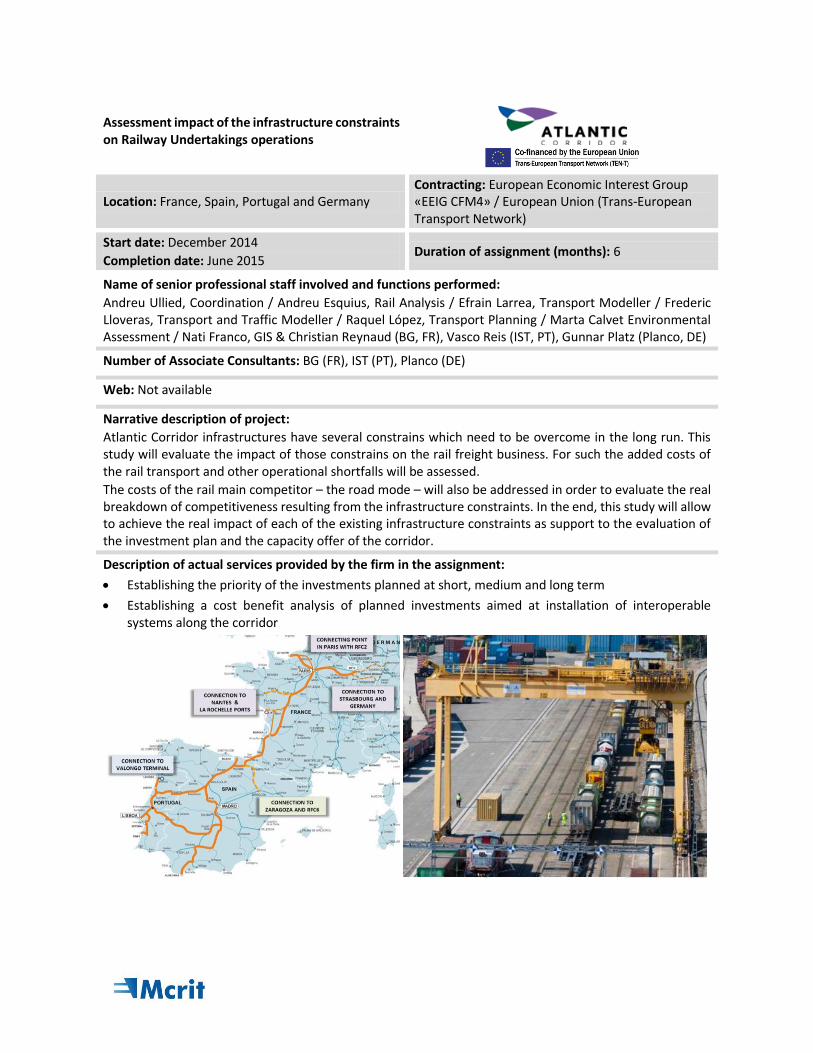
Atlantic Corridor infrastructures have several constrains which need to be overcome in the long run. This study will evaluate the impact of those constrains on the rail freight business. For such the added costs of the rail transport and other operational shortfalls will be assessed.
The costs of the rail main competitor – the road mode – will also be addressed in order to evaluate the real breakdown of competitiveness resulting from the infrastructure constraints. In the end, this study will allow to achieve the real impact of each of the existing infrastructure constraints as support to the evaluation of the investment plan and the capacity offer of the corridor.
Description of actual services provided by the firm in the assignment:
Establishing the priority of the investments planned at short, medium and long term
Establishing a cost benefit analysis of planned investments aimed at installation of interoperable systems along the corridor
Review of methodologies for the selection of infrastructures in urban areas
Location: Catalonia (Spain) Contracting: Metropolitan Transport Authority (ATM)
Start date: May 2018
Completion date: November 2018 Duration of assignment (months): 6
Name of senior professional staff involved and functions performed:
Andreu Esquius, Director / Raquel López, Modelling / Judith Requena, Social impact analysis / Oriol Biosca, Methodological analysis / Albert Solés, Methodological analysis / Rafa Rodrigo, Methodological analysis
Number of Associate Consultants: 4
Web: Restricted
Narrative description of project:
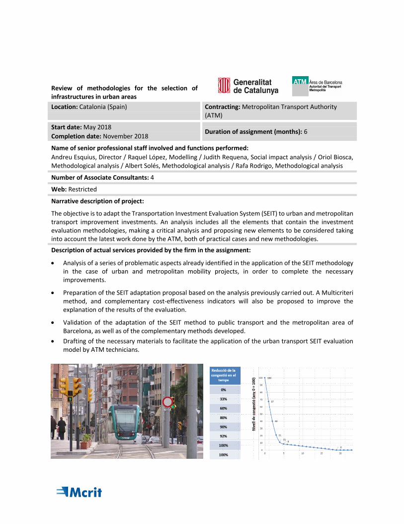
The objective is to adapt the Transportation Investment Evaluation System (SEIT) to urban and metropolitan transport improvement investments. An analysis includes all the elements that contain the investment evaluation methodologies, making a critical analysis and proposing new elements to be considered taking into account the latest work done by the ATM, both of practical cases and new methodologies.
Description of actual services provided by the firm in the assignment:
Analysis of a series of problematic aspects already identified in the application of the SEIT methodology in the case of urban and metropolitan mobility projects, in order to complete the necessary improvements.
Preparation of the SEIT adaptation proposal based on the analysis previously carried out. A Multicriteri method, and complementary cost-effectiveness indicators will also be proposed to improve the explanation of the results of the evaluation.
Validation of the adaptation of the SEIT method to public transport and the metropolitan area of Barcelona, as well as of the complementary methods developed.
Drafting of the necessary materials to facilitate the application of the urban transport SEIT evaluation model by ATM technicians.