Embed Size (px)
Citation preview

U.S. Department of the Interior U.S. Geological Survey
Living With a Volcano in Your Back Yard: Mount Rainier Volcanic Hazards
A prepared presentation for use by public officials and educators
By: C. L. Driedger, E. W. Wolfe, K. M. Scott
Open-file Report 98-519-A
In cooperation with: Washington Military Department Emergency Management Division
U.S. Department of the InteriorBruce Babbitt, Secretary
U.S. Geological SurveyThomas J. Casadevall, Acting Director
Cover Photo: Mount Rainier above Tacoma skyline, Lyn Topinka, U.S. Geological Survey.
This report is preliminary and has not been reviewed for conformity with U.S. Geological Survey editorial standards or with the North American Stratigraphic Code. Any use of trade, firm, or product names is for descriptive purposes only and does not imply endorsement by the U.S. Government.
To purchase USGS publications contact:
U.S. Geological Survey Information Services P.O. Box 25286 Denver, CO 80225 (303)202-4210

Contents and Photo Credits
Foreword and Acknowledgments1. Introductory slide, (all slide graphics were prepared by Lisa Faust unless otherwise stated)2. Mount Rainier looms above Tacoma skyline, Lyn Topinka, U.S. Geological Survey (USGS)3. Maj or points of presentation4. Cascade volcano eruption time line, Bobbie Myers, USGS5. Ring of Fire, modified from Tilling, R.I., and others, 19876. Regional geological setting, modified from Yelin, T.S., and others., 1994 1. Home damage in West Seattle, © Steinbrugge Collection, Earthquake Engineering Research
Center, University of California, Berkeley8. Earthquake Sources at Mount Rainier, modified from Moron, S., 19979. Craters at summit of Mount Rainier, Donal Mullineaux, USGS10. Mount Rainier and Puyallup Valley, David Wieprecht, USGS11. Cutaway view of volcano, Bobbie Myers, USGS12. Yakima, WA engulfed by volcanic ash at noon on May 18 th, 1980, U.S. Forest Service13. Text slide about volcanic ash14. Map of potential ash fall from Mount Rainier, modified from Hoblitt, R.P., and others, 199815. Lava flows on Villa Rica volcano ©Hugo Moreno, Servicio National de Geologia y Mineria,
Chile16. Text slide about lava17. Pyroclastic flow on Montserrat volcano, Willie Scott, USGS18. Text slide about pyroclastic flows19. Map of lava and pyroclastic flow hazards at Mount Rainier, modified from Hoblitt, R..P., and
others, 199820. Alps debris flow, ©Mr. Toni Venzin, Tren, Canton ofGrisons, Switzerland21. Lahar produced by snow melt at Armero, Colombia, Richard Janda, USGS22. Mount Rainier from the northeast, Carolyn Driedger, USGS23. Beginning of landslide that produced Osceola Mudflow, Jose Vigil, USGS24. Northeast-facing crater after Osceola Landslide, Jose Vigil, USGS25. Maps showing pre- and post-Osceola Mudflow shorelines, modified from Dragovich, and
others, 199426. Hydrothermally-altered rock, Dave Zimbelman, USGS27. Map Osceola and Electron lahars, Vallance and Scott, 1997, modified from Crandell,
197128. Recently exhumed tree stump covered by Electron Mudflow sediment, Patrick Pringle
Washington Department of Natural Resource (WaDNR)29. Text slide about lahars30. Native watching lahar, © by Linda Feltner, Seattle, WA.31. Mount Rainier and mid-Puyallup River Valley communities, David Wieprecht, USGS32. Map of lahar hazard zones, Hoblitt, R.P. and others, 199833. Text slide How to outwit a lahar, photograph by Carolyn Driedger, USGS34. Scientists monitoring Mount Rainier, Lyn Topinka, USGS35. Emergency Services personnel on the job, Pierce County Department of Emergency
Management (PCDEM)36. Text slide simple steps to lessen volcanic risk37. Scenarios for the future, David Wieprecht, USGS38. Where to go for more information References
U.S. Department of the Interior U.S. Geological Survey
Living With a Volcano in Your Back Yard Mount Rainier Volcanic Hazards
A prepared presentation for use by public officials and educators
By: C. L. Driedger, E. W. Wolfe, K. M. Scott
Open-file Report 98-519-A
In cooperation with: Washington Military Department Emergency Management Division

U.S. Department of the InteriorBruce Babbitt, Secretary
U.S. Geological SurveyThomas J. Casadevall, Acting Director
Cover Photo: Mount Rainier above Tacoma skyline, Lyn Topinka, U.S. Geological Survey.
This report is preliminary and has not been reviewed for conformity with U.S. Geological Survey editorial standards or with the North American Stratigraphic Code. Any use of trade, firm, or product names is for descriptive purposes only and does not imply endorsement by the U.S. Government.
To purchase USGS publications contact:
U.S. Geological Survey Information Services P.O. Box 25286 Denver, CO 80225 (303)202-4210

Contents and Photo CreditsForeword and Acknowledgments1. Introductory slide, (all slide graphics were prepared by Lisa Faust unless otherwise stated)2. Mount Rainier looms above Tacoma skyline, Lyn Topinka, U.S. Geological Survey (USGS)3. Major points of presentation4. Cascade volcano eruption time line, Bobbie Myers, USGS5. Ring of Fire, modified from Tilling, R.L, and others, 19876. Regional geological setting, modified from Yelin, T.S., and others., 1994 1. Home damage in West Seattle, © Steinbrugge Collection, Earthquake Engineering Research
Center, University of California, Berkeley8. Earthquake Sources at Mount Rainier, modified from Moron, S., 19979. Craters at summit of Mount Rainier, Donal Mullineaux, USGS10. Mount Rainier and Puyallup Valley, David Wieprecht, USGS11. Cutaway view of volcano, Bobbie Myers, USGS12. Yakima, WA engulfed by volcanic ash at noon on May 18th, 1980, U.S. Forest Service13. Text slide about volcanic ash14. Map of potential ash fall from Mount Rainier, modified from Hoblitt, R.P., and others, 199815. Lava flows on Villa Rica volcano ©Hugo Moreno, Servicio National de Geologia y Mineria,
Chile16. Text slide about lava17. Pyroclastic flow on Montserrat volcano, Willie Scott, USGS18. Text slide about pyroclastic flows19. Map of lava and pyroclastic flow hazards at Mount Rainier, modified from Hoblitt, R..P., and
others, 199820. Alps debris flow, © Mr. Toni Venzin, Tren, Canton ofGrisons, Switzerland21. Lahar produced by snow melt at Armero, Colombia, Richard Janda, USGS22. Mount Rainier from the northeast, Carolyn Driedger, USGS23. Beginning of landslide that produced Osceola Mudflow, Jose Vigil, USGS24. Northeast-facing crater after Osceola Landslide, Jose Vigil, USGS25. Maps showing pre- and post-Osceola Mudflow shorelines, modified from Dragovich, and
others, 199426. Hydrothermally-altered rock, Dave Zimbelman, USGS27. Map Osceola and Electron lahars, Vallance and Scott, 1997, modified from Crandell,
197128. Recently exhumed tree stump covered by Electron Mudflow sediment, Patrick Pringle
Washington Department of Natural Resource (WaDNR)29. Text slide about lahars30. Native watching lahar, © by Linda Feltner, Seattle, WA.31. Mount Rainier and mid-Puyallup River Valley communities, David Wieprecht, USGS32. Map of lahar hazard zones, Hoblitt, R.P. and others, 199833. Text slide How to outwit a lahar, photograph by Carolyn Driedger, USGS34. Scientists monitoring Mount Rainier, Lyn Topinka, USGS35. Emergency Services personnel on the job, Pierce County Department of Emergency
Management (PCDEM)36. Text slide simple steps to lessen volcanic risk37. Scenarios for the future, David Wieprecht, USGS38. Where to go for more information References

Foreword
This presentation is compiled by the U.S. Geological Survey at the request of the Mount Rainier Volcanic Hazards Working Group, a group of officials from communities and agencies dedicated to reducing loss of life and property by providing a planned response to volcanic hazards at Mount Rainier. The presentation is designed for educators who want to teach others about the volcanic hazards at Mount Rainier. It can be used in total, edited for specific audiences, or used as part of a larger presentation.
All graphics produced by the USGS, Washington State Department of Natural Resources, and Pierce County Department of Emergency Management are within the Public Domain and can be copied with proper reference to the photographers; all other graphics are subject to copyright law and any reproduction requires permission from the owner.
AcknowledgmentsThe authors received suggestions on format and content from members of the Mount Rainier Volcanic Hazards Working Group. Shawn Jones, Seth Moran, Patrick Pringle, Richard Schroedel, and Barbara Thurmond reviewed the text. Lisa Faust produced graphics, and Bobbie Myers provided the Cascade eruptions time line and cutaway volcano. Nina Portwood Shields assembled the final product. We thank all of them for making improvements and for assembly of this presentation. We also acknowledge and thank educators and public officials who bring the message about volcanic hazards to the people of the Pacific Northwest.

Living With a Volcano in Your Back Yard: Mount Rainier Volcanic HazardsA prepared presentation for use by public officials and educators
#1Introductory slide
Caption:This presentation is compiled by the U.S. Geological Survey at the request of the Mount Rainier Volcanic Hazards Work Group, an group of officials from communities and agencies dedicated to reducing loss of life and property by providing a planned response to volcanic hazards at Mount Rainier.
#2Mount Rainier looms above Tacoma skyline.
Caption:Mount Rainier has been described as "the guardian of the Pacific Northwest" and "Washington's playground". Its immense height (14,410 feet), glistening snow-covered slopes, and delicate alpine environment make it one of the most popular visitor destinations in Washington State.
Glaciers, lava flows, landslides, and lahars sculptured Mount Rainier. As recently as the last 500 years, powerful forces at Mount Rainier have transformed the landscape around Puget Sound, where thousands of people now live and work. These same forces continue to reshape the landscape and create hidden hazards to people in the Pacific Northwest.
The occurrence of future hazardous volcanic events is assured. The first step toward living with these hazards is for us to understand them. Citizens can then address emergency preparedness for their families and communities. These actions can lower anxieties, reduce the risks, and provide a greater measure of safety for those who live, work, and play in the vicinity of Mount Rainier.
#3Major points of presentation
Caption:Here are the major points to be discussed:1.) Related geologic processes cause both earthquakes and volcanoes in the Pacific Northwest.2.) Mount Rainier is an "active" volcano.3.) Volcanic processes that built Mount Rainier are a continuing threat.4.) Lahars (mudflows) are the greatest volcanic hazard at Mount Rainier.5.) Simple steps taken now can reduce the consequences of future volcanic events.
Living with a volcano in your back yard 1
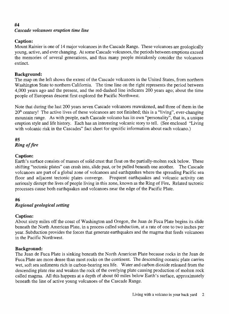
#4Cascade volcanoes eruption time line
Caption:Mount Rainier is one of 14 major volcanoes in the Cascade Range. These volcanoes are geologically young, active, and ever changing. At some Cascade volcanoes, the periods between eruptions exceed the memories of several generations, and thus many people mistakenly consider the volcanoes extinct.
Background:The map on the left shows the extent of the Cascade volcanoes in the United States, from northern Washington State to northern California. The time line on the right represents the period between 4,000 years ago and the present, and the red-dashed line indicates 200 years ago; about the time people of European descent first explored the Pacific Northwest.
Note that during the last 200 years seven Cascade volcanoes reawakened, and three of them in the 20th century! The active lives of these volcanoes are not finished; this is a "living", ever-changing mountain range. As with people, each Cascade volcano has its own "personality", that is, a unique eruption style and life history. Each has an interesting volcanic story to tell. (See enclosed "Living with volcanic risk in the Cascades" fact sheet for specific information about each volcano.)
#5Ring of fire
Caption:Earth's surface consists of masses of solid crust that float on the partially-molten rock below. These shifting "tectonic plates" can crash into, slide past, or be pulled beneath one another. The Cascade volcanoes are part of a global zone of volcanoes and earthquakes where the spreading Pacific sea floor and adjacent tectonic plates converge. Frequent earthquakes and volcanic activity can seriously disrupt the lives of people living in this zone, known as the Ring of Fire. Related tectonic processes cause both earthquakes and volcanoes near the edge of the Pacific Plate.
#6Regional geological setting
Caption:About sixty miles off the coast of Washington and Oregon, the Juan de Fuca Plate begins its slide beneath the North American Plate, in a process called subduction, at a rate of one to two inches per year. Subduction provides the forces that generate earthquakes and the magma that feeds volcanoes in the Pacific Northwest.
Background:The Juan de Fuca Plate is sinking beneath the North American Plate because rocks in the Juan de Fuca Plate are more dense than most rocks on the continent. The descending oceanic plate carries wet, soft sea sediments rich in carbon-bearing sea life. Water and carbon dioxide released from the descending plate rise and weaken the rock of the overlying plate causing production of molten rock called magma. All this happens at a depth of about 60 miles below Earth's surface, approximately beneath the line of active young volcanoes of the Cascade Range.
Living with a volcano in your back yard 2

#7Home damage in West Seattle
Caption:All this pushing and shoving of tectonic plates causes rock to bend and shift under the stress of constant pressure. Sometimes the rocks snap and cause regional earthquakes. Regional earthquakes can be quite disruptive to communities in the Pacific Northwest, such as the Seattle-Tacoma earthquake in the Seattle area on April 29, 1965, that toppled chimneys and caused 50 million dollars in damage, as illustrated in this photograph.
#8Earthquake Sources at Mount Rainier
Caption:Large regional earthquakes don't initiate volcanic eruptions, but they can shake loose rockfalls, landslides, and snow avalanches on the slopes of Mount Rainier. Earthquakes at Mount Rainier have a variety of sources.
A small fault zone on the west side of the Park called the Western Rainier Seismic Zone (WRSZ) causes about 100 earthquakes per year. The largest recorded earthquake along this zone was a magnitude 4.1 in 1994. Movements of glacial ice and rockfalls cause small earthquakes at the volcano's surface. Movement of hot fluids, in conjunction with settling of the volcano into the earth's crust, are thought to cause earthquakes at depths of one to two miles below the summit.
Seismologists watch the earthquake record at Mount Rainier in search of earthquakes caused by rising magma. These earthquakes are often the first indicators of volcanic reawakening and impending eruptions.
#9Craters at summit of Mount Rainier
Caption:Mount Rainier is an active volcano that it is currently between eruptions. Glaciers, rockfalls, and landslides erode Mount Rainier's slopes. This erosion makes the volcano look old, but in fact, it is geologically young less than 600,000 years old. Mount Rainier has erupted frequently. Its current summit cone was emplaced between 1,200 and 2,100 years ago. It erupted on multiple occasions in the 19th century, and, according to pioneer reports, erupted steam most recently in 1894. The same volcanic processes that shaped Mount Rainier as we now know it are hazards to current residents of the Pacific Northwest.
Living with a volcano in your back yard 3

#10Mount Rainier and Puyallup River Valley
Caption:Mount Rainier's one cubic mile load of permanent snow and ice presents a major hydrologic hazard when combined with hot volcanic material erupted during volcanic eruptions. In addition, some large landslides have occurred, apparently unaccompanied by eruptions, and traveled through areas now densely populated. The presence of volcanic heat and earthquakes inside Mount Rainier indicate that the volcano is still active. It's not a matter of "if, but "when" Mount Rainier erupts or produces a landslide again.
Background:Mount Rainier stands two-and-a-half miles above the Puyallup valley floor and sea level. Note the vast covering of ice and perennial snow (snow that remains from year to year). About 34 square miles of snow and ice cover Mount Rainier (enough to pave a road one mile wide between the cities of Tacoma and the south end of Seattle). Volumetrically, the cubic-mile of perennial snow and ice is equivalent to the perennial snow and ice on all other Cascade volcanoes combined! For comparison, if the Seattle Kingdome were an ice cream scoop, it would take 2,300 scoops to remove all the snow and ice from Mount Rainier! The valley floor in the photo is made almost entirely of sediment from Mount Rainier from streams carrying sediment and from lahars (volcanic mudflows).
#11Cutaway view of volcano
Caption:This diagram shows 13 surficial volcanic processes that occur on Pacific Northwest volcanoes that may be hazardous to local inhabitants. We will examine five: volcanic ash, lava flows, pyroclastic flows, landslides, and lahars. In the coming slides we'll discuss each of these processes and whether they are a hazard to people near Mount Rainier. The meaning of these terms will become apparent in time.
Background: Mount Rainier derives its magma (hot, molten rock) from rocks about 60 miles below Earth's surface. There, minerals and gases such as water, carbon dioxide, and sulfur dioxide concentrate. Eventually pressure in the magma reservoir forces a column of rising magma to the surface, initiating an eruption.
As magma ascends, the pressure within the magma decreases and gases are released from the magma solution. Gas bubbles within the magma expand rapidly to form a froth of molten rock, similar to the foam rising from a newly opened bottle of champagne. The bubble walls rapidly cool and harden, and a mixture of gas and rock fragments erupts into the atmosphere. The rock fragments are known collectively as tephra. The larger fragments, in which masses of bubbles are preserved, form pumice. The smaller fragments, mostly pieces of broken bubble walls and crystals, are called volcanic ash. This mixture of hot volcanic gases, heated air, and rock fragments is less dense than the surrounding atmosphere and may rise buoyantly tens of thousands of feet.
Living with a volcano in your back yard 4
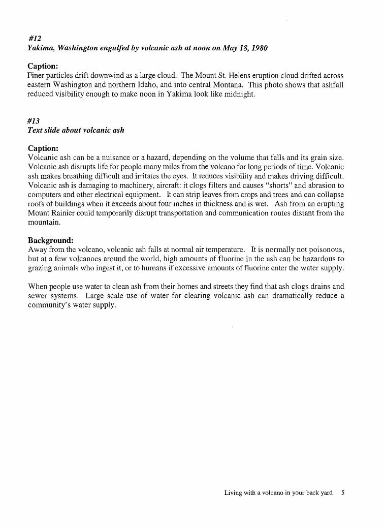
#12Yakima, Washington engulfed by volcanic ash at noon on May 18,1980
Caption:Finer particles drift downwind as a large cloud. The Mount St. Helens eruption cloud drifted across eastern Washington and northern Idaho, and into central Montana. This photo shows that ashfall reduced visibility enough to make noon in Yakima look like midnight.
#73Text slide about volcanic ash
Caption:Volcanic ash can be a nuisance or a hazard, depending on the volume that falls and its grain size. Volcanic ash disrupts life for people many miles from the volcano for long periods of time. Volcanic ash makes breathing difficult and irritates the eyes. It reduces visibility and makes driving difficult. Volcanic ash is damaging to machinery, aircraft: it clogs filters and causes "shorts" and abrasion to computers and other electrical equipment. It can strip leaves from crops and trees and can collapse roofs of buildings when it exceeds about four inches in thickness and is wet. Ash from an erupting Mount Rainier could temporarily disrupt transportation and communication routes distant from the mountain.
Background:Away from the volcano, volcanic ash falls at normal air temperature. It is normally not poisonous, but at a few volcanoes around the world, high amounts of fluorine in the ash can be hazardous to grazing animals who ingest it, or to humans if excessive amounts of fluorine enter the water supply.
When people use water to clean ash from their homes and streets they find that ash clogs drains and sewer systems. Large scale use of water for clearing volcanic ash can dramatically reduce a community's water supply.
Living with a volcano in your back yard 5
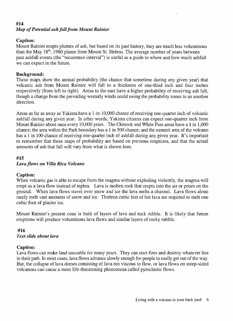
#14Map of Potential ash fall from Mount Rainier
Caption:Mount Rainier erupts plumes of ash, but based on its past history, they are much less voluminous than the May 18th , 1980 plume from Mount St. Helens. The average number of years between past ashfall events (the "recurrence interval") is useful as a guide to where and how much ashfall we can expect in the future.
Background:These maps show the annual probability (the chance that sometime during any given year) that volcanic ash from Mount Rainier will fall to a thickness of one-third inch and four inches respectively (from left to right). Areas to the east have a higher probability of receiving ash fall, though a change from the prevailing westerly winds could swing the probability zones to an another direction.
Areas as far as away as Yakima have a 1-in-10,000 chance of receiving one-quarter inch of volcanic ashfall during any given year. In other words, Yakima citizens can expect one-quarter inch from Mount Rainier about once every 10,000 years. The Chinook and White Pass areas have a 1 in 1,000 chance; the area within the Park boundary has a 1 in 500 chance; and the summit area of the volcano has a 1 in 100 chance of receiving one-quarter inch of ashfall during any given year. It's important to remember that these maps of probability are based on previous eruptions, and that the actual amounts of ash that fall will vary from what is shown here.
#15Lava flows on Villa Rica Volcano
Caption:When volcanic gas is able to escape from the magma without exploding violently, the magma will erupt as a lava flow instead of tephra. Lava is molten rock that erupts into the air or pours on the ground. When lava flows travel over snow and ice the lava melts a channel. Lava flows alone rarely melt vast amounts of snow and ice. Thirteen cubic feet of hot lava are required to melt one cubic foot of glacier ice.
Mount Rainier's present cone is built of layers of lava and rock rubble. It is likely that future eruptions will produce voluminous lava flows and similar layers of rocky rubble.
#16Text slide about lava
Caption:Lava flows can make land unusable for many years. They can start fires and destroy whatever lies in their path. In most cases, lava flows advance slowly enough for people to easily get out of the way. But, the collapse of lava domes consisting of lava too viscous to flow, or lava flows on steep-sided volcanoes can cause a more life-threatening phenomena called pyroclastic flows.
Living with a volcano in your back yard 6
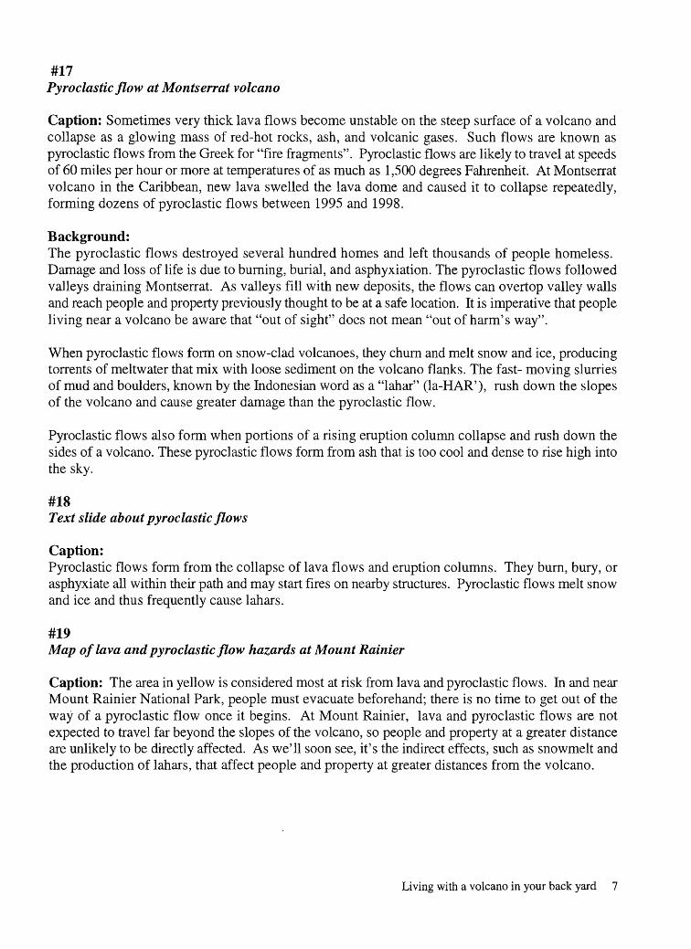
#17 Pyroclastic flow atMontserrat volcano
Caption: Sometimes very thick lava flows become unstable on the steep surface of a volcano and collapse as a glowing mass of red-hot rocks, ash, and volcanic gases. Such flows are known as pyroclastic flows from the Greek for "fire fragments". Pyroclastic flows are likely to travel at speeds of 60 miles per hour or more at temperatures of as much as 1,500 degrees Fahrenheit. At Montserrat volcano in the Caribbean, new lava swelled the lava dome and caused it to collapse repeatedly, forming dozens of pyroclastic flows between 1995 and 1998.
Background:The pyroclastic flows destroyed several hundred homes and left thousands of people homeless. Damage and loss of life is due to burning, burial, and asphyxiation. The pyroclastic flows followed valleys draining Montserrat. As valleys fill with new deposits, the flows can overtop valley walls and reach people and property previously thought to be at a safe location. It is imperative that people living near a volcano be aware that "out of sight" does not mean "out of harm's way".
When pyroclastic flows form on snow-clad volcanoes, they churn and melt snow and ice, producing torrents of meltwater that mix with loose sediment on the volcano flanks. The fast- moving slurries of mud and boulders, known by the Indonesian word as a "lahar" (la-HAR'), rush down the slopes of the volcano and cause greater damage than the pyroclastic flow.
Pyroclastic flows also form when portions of a rising eruption column collapse and rush down the sides of a volcano. These pyroclastic flows form from ash that is too cool and dense to rise high into the sky.
#18Text slide about pyroclastic flows
Caption:Pyroclastic flows form from the collapse of lava flows and eruption columns. They burn, bury, or asphyxiate all within their path and may start fires on nearby structures. Pyroclastic flows melt snow and ice and thus frequently cause lahars.
#19Map of lava and pyroclastic flow hazards at Mount Rainier
Caption: The area in yellow is considered most at risk from lava and pyroclastic flows. In and near Mount Rainier National Park, people must evacuate beforehand; there is no time to get out of the way of a pyroclastic flow once it begins. At Mount Rainier, lava and pyroclastic flows are not expected to travel far beyond the slopes of the volcano, so people and property at a greater distance are unlikely to be directly affected. As we'll soon see, it's the indirect effects, such as snowmelt and the production of lahars, that affect people and property at greater distances from the volcano.
Living with a volcano in your back yard 7

#20Alps debris flow
Caption:Lahars are the greatest volcanic hazard at Mount Rainier. They are floods of water, mud, sand, and rock that originate as landslides or as slurries of rock and meltwater. At speeds of 40 mph or more they rush down the slopes of a volcano and into the valleys below.
Lahars, sometimes known as mudflows or debris flows, are tremendously powerful. They can destroy everything within their paths. Damage is done from impacts by large boulders or logs in the flow, and by abrasion, burial, and post-lahar flooding. What might a lahar looked like as it speeds down valley? This relatively small debris flow in the Alps (July 18, 1987) gives some idea.
#21Lahar produced by snow melt atArmero, Colombia
Caption:Lahars are a particular hazard in the Cascades because during eruptions, hot pyroclastic flows sprawl across glaciers and snowfields and melt snow and ice. This photo illustrates the devastation resulting from a lahar caused by the eruption of snow-and-ice-capped Nevado del Ruiz volcano in Colombia.
On November 13th, 1985, Nevado del Ruiz erupted a small amount of volcanic ash and pyroclastic flows. The pyroclastic flows melted snow and ice and transformed into a lahar that flowed down canyons on the volcano flanks, enlarging as it engulfed rock and mud in the river bed. Traveling at an average velocity of 20 miles per hour, the lahar took two and a quarter hours to reach the city of Armero. There it spilled out onto the broad surface below the canyon mouth, and swept away or buried much of the city of Armero. At least 20,000 people were killed by this lahar. The people of Armero would have been safe if they had forewarning and simply climbed to higher ground on the nearby valley walls.
Downstream from a volcano, there is usually time to move out of harm's way if you know a lahar is coming; usually you need only to climb 75-100 yards up the valley walls.
#22Mount Rainier from the northeast
Caption:Landslides can also produce lahars. This photo shows Mount Rainier from the northeast. Geologists think this is the site of a massive landslide that originated when a mass of rising magma forced the northeast slope of Mount Rainier to bulge about 5,700 years ago. The bulge happened in the upper reaches of the mountain now covered by Ernmons Glacier, visible in this slide. Perhaps it was similar to the bulge that preceded the catastrophic landslide and eruption on Mount St. Helens in May, 1980.
Living with a volcano in your back yard 8
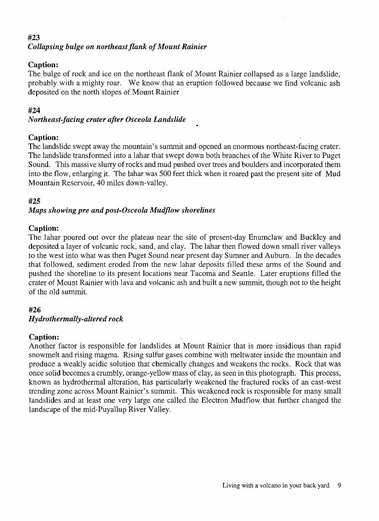
#23Collapsing bulge on northeast flank of Mount Rainier
Caption:The bulge of rock and ice on the northeast flank of Mount Rainier collapsed as a large landslide, probably with a mighty roar. We know that an eruption followed because we find volcanic ash deposited on the north slopes of Mount Rainier
#24Northeast-facing crater after Osceola Landslide
Caption:The landslide swept away the mountain's summit and opened an enormous northeast-facing crater. The landslide transformed into a lahar that swept down both branches of the White River to Puget Sound. This massive slurry of rocks and mud pushed over trees and boulders and incorporated them into the flow, enlarging it. The lahar was 500 feet thick when it roared past the present site of Mud Mountain Reservoir, 40 miles down-valley.
#25Maps showing pre and post-Osceola Mudflow shorelines
Caption:The lahar poured out over the plateau near the site of present-day Enumclaw and Buckley and deposited a layer of volcanic rock, sand, and clay. The lahar then flowed down small river valleys to the west into what was then Puget Sound near present day Sumner and Auburn. In the decades that followed, sediment eroded from the new lahar deposits filled these arms of the Sound and pushed the shoreline to its present locations near Tacoma and Seattle. Later eruptions filled the crater of Mount Rainier with lava and volcanic ash and built a new summit, though not to the height of the old summit.
#26 Hydrothermally-altered rock
Caption:Another factor is responsible for landslides at Mount Rainier that is more insidious than rapid snowmelt and rising magma. Rising sulfur gases combine with meltwater inside the mountain and produce a weakly acidic solution that chemically changes and weakens the rocks. Rock that was once solid becomes a crumbly, orange-yellow mass of clay, as seen in this photograph. This process, known as hydrothermal alteration, has particularly weakened the fractured rocks of an east-west trending zone across Mount Rainier's summit. This weakened rock is responsible for many small landslides and at least one very large one called the Electron Mudflow that further changed the landscape of the mid-Puyallup River Valley.
Living with a volcano in your back yard 9

#27Map Osceola and Electron Lahars:
Caption:About 550 years ago, hydrothermally-altered rock broke loose from the weakened upper west slope of Mount Rainier. It rushed into the Puyallup River drainage and produced the Electron Mudflow that overran the present site of Orting with about twenty feet of rocks and mud before flowing to Puget Sound.
#28Recently exhumed tree stump covered by Electron Mudflow sediment
Caption:The Electron lahar engulfed an old-growth forest that stood on the valley floor and probably killed many native people. Broken tree trunks, such as the stump visible to the right of center of the photograph, were killed by the Electron Mudflow and other lahars. These are uncovered frequently as excavators dig trenches for utilities that support development in the Puyallup and Kent-Auburn valleys. The old-growth forests undoubtedly slowed the lahars. One estimate is that a modern lahar the same size as the Electron would travel faster and cover 40 percent more area.
The Electron Mudflow appears to have been unaccompanied by an eruption. Today, scientists detect rising magma regularly before an eruption and can warn inhabitants and public officials. But, a landslide without the warning signs of rising magma and accompanying earthquakes could happen any time and without warning.
Background:Some geologists note that regional earthquakes can shake loose large landslides and may have shaken loose some previous landslides at Mount Rainier. But, the timing of landslides and earthquakes is not known sufficiently to verify this at Mount Rainier. The Electron Mudflow moved between 200 and 300 million cubic yards of rock into the Puyallup River valley, further filling the valley with rocky sediments.
#29Text slide about lahars
Caption:Lahars are floods of water, mud, sand and rock that originate as landslides of water-saturated, hydrothermally-altered rock, or as slurries of rock and meltwater generated by eruptions or flash floods of glacial melt water. Lahars destroy all within their direct path. They travel at speeds that often exceed 40 miles per hour. Because they travel great distances, lahars put people at risk tens of miles from the volcano. Lahars displace river beds and cause flooding for years after their occurrence.
Living with a volcano in your back yard 10
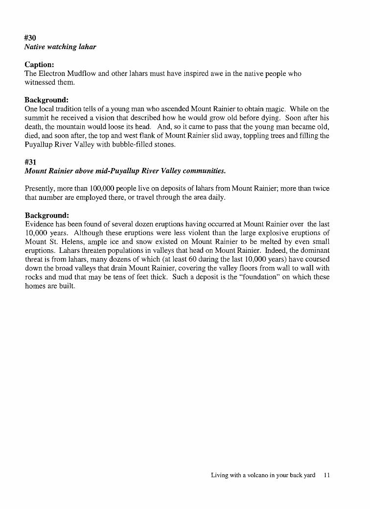
#30Native watching lahar
Caption:The Electron Mudflow and other lahars must have inspired awe in the native people who witnessed them.
Background:One local tradition tells of a young man who ascended Mount Rainier to obtain magic. While on the summit he received a vision that described how he would grow old before dying. Soon after his death, the mountain would loose its head. And, so it came to pass that the young man became old, died, and soon after, the top and west flank of Mount Rainier slid away, toppling trees and filling the Puyallup River Valley with bubble-filled stones.
#31Mount Rainier above mid-Puyallup River Valley communities.
Presently, more than 100,000 people live on deposits of lahars from Mount Rainier; more than twice that number are employed there, or travel through the area daily.
Background:Evidence has been found of several dozen eruptions having occurred at Mount Rainier over the last 10,000 years. Although these eruptions were less violent than the large explosive eruptions of Mount St. Helens, ample ice and snow existed on Mount Rainier to be melted by even small eruptions. Lahars threaten populations in valleys that head on Mount Rainier. Indeed, the dominant threat is from lahars, many dozens of which (at least 60 during the last 10,000 years) have coursed down the broad valleys that drain Mount Rainier, covering the valley floors from wall to wall with rocks and mud that may be tens of feet thick. Such a deposit is the "foundation" on which these homes are built.
Living with a volcano in your back yard 11

#32Map oflahar hazard zones
Caption:This map shows areas most at risk from lahars.
Background:Scientists have delineated areas that they think are most at risk from lahars in the future by examining where lahars have traveled in the past. Lahars have generally flowed in valleys and except near the volcano, have rarely traveled over ridge tops. Thus, the principal risk is in valley bottoms. This map shows the location of areas most at risk from lahars of different origins. As a guide to where lahars of landslide origin might travel, scientists superimposed a hypothetical lahar the size of the Electron Mudflow onto the present surface of each valley around Mount Rainier. Hazard zones for these types of lahar are shown in yellow. Lahars formed by intense snowmelt and intense precipitation are modeled after the National Lahar of about 2,000 years ago and are shown in red. Lahars formed by small disturbances in valleys, such as glacial floods, are shown in blue. Numbers in the key show the "recurrence interval", the average number of years between such events in the past.
Fine sediment deposits, delivered to valley bottoms by lahars and other processes, may be susceptible to liquefaction during earthquakes. Structures built on these deposits are particularly susceptible to damage.
#33Text slide about how to outwit a lahar
Caption:Downstream from a volcano, there is time to move "out of harm's way". If you know alahar is coming; you need only climb up out of the valley to escape it.
#34Scientists Monitoring Mount Rainier
Caption:At present it is not possible to determine when Mount Rainier will reawaken. But, once scientists note deep earthquakes caused by rising magma, they can predict approximately how soon an eruption will occur.
Scientists watch for signs of renewed activity at Mount Rainier by observing the character of earthquakes; by making long-term measurements to detect ground deformation; by measuring gas releases; and by visual observation of changes on the mountain. Earthquakes caused by rising magma are the best indicators of potential eruptive activity. Monitoring can help determine the timing of eruptions, but does not provide protection from rock fall and landslides.
Living with a volcano in your back yard 12

#35Emergency services personnel on the job
Caption:Citizen volunteers and public officials at the local, State, and Federal levels have assembled an emergency response plan to help coordinate evacuations and aid to people affected by eruptions or lahars. Public officials in each community are part of a larger network of specialists in communications, rescue, first aid, and volcanoes, who will share their expertise before and during a volcanic crisis.
#36"Whatyou can do"
Caption:
Learn: Learn whether you live, work, or go to school in a volcanic hazard zone. Learn about all volcanic processes that affect your community.
Plan: Develop an emergency plan with your family or business to help you during any natural disaster.
Inquire: Ask local officials how they advise you to respond.Ask public officials ahead of time how they advise you to respond during any emergency.
#37Scenarios for the future
Caption:When Mount Rainier reawakens it could tease us. It may sputter and erupt small quantities of steam, or produce no other evidence of magma movement besides earthquakes. But when a large eruption occurs, and it will, hot pyroclastic flows may melt snow and ice and produce lahars. Lahars and flooding of displaced rivers can disrupt the lives of hundreds to tens of thousands of people.
Limiting concentrations of people in the paths of lahars, installing lahar detection systems, preparing emergency plans, and planning and practicing evacuations can lower the loss of life and property during an eruption or lahar. These actions can reduce the risk and provide a measure of safety for those who live, work, and play in valleys surrounding Mount Rainier.
Living with a volcano in your back yard 13

#38"Where to go for more information'
Caption:For more information contact:
U.S. Geological SurveyCascades Volcano Observatory
5400 MacArthur Blvd.Vancouver, WA 98661
(360) 696-7693 http:// vulcan.wr.usgs.gov
AND Your local emergency management agency
Living with a volcano in your back yard 14
References
Blong, R.J., 1984, Volcanic hazards: Academic Press, Orlando, Florida, 424 p.
Clark, E.E., 1953, Indian Legends of the Pacific Northwest: University of California Press, Berkeley, California, 225 p.
Crandell, D.R., 1971, Postglacial lahars from Mount Rainier, volcano, Washington: U.S. Geological Survey Professional Paper 667, 75 p.
Crowley, J.K., and Zimbelman, D.R., 1997, Mapping hydrothermally altered rocks on Mount Rainier, Washington, with airborne visible/infrared imaging spectrometer (AVRIS) data: Geology, v.25, p. 481-576.
Dragovich, J.D., Pringle, P.T., and Walsh, T.J., 1994, Extent and geometry of the Mid-Holocene Osceola Mudflow in the Puget Lowland implications for Holocene sedimentation and Paleogeography: Washington Geology, v. 22, no.3, p. 3-26.
Dragovich, J.D., and Pringle, P.T., 1995, Liquefaction susceptibility for the Sumner 7.5-minute quadrangle: Washington Department of Geology and Earth Resources Geologic Map GM- 44, 26 p., 1 pi.
Driedger, C.L., and Kennard, P.M., 1986, Ice Volumes on Cascade volcanoes Mount Rainier, Mount Hood, Three Sisters, and Mount Shasta: U.S. Geological Survey Professional Paper 1365, 28 p., 3 pi.
Ewert, J.K., Brantley, S.R., and Myers, B., 1994, The next eruption in the Cascades: U.S. Geological Survey Open-file Report 94-585, 5 p.
Hoblitt, R.P., Walder, J.S., Driedger, C.L., Scott, K.M., Pringle, P.T., and Vallance, J.W., 1998, Volcano Hazards from Mount Rainier, Washington, revised 1998: Open-file Report 98-428, 11 p., 1 pi.
Moran, S.C., 1997, Three-dimensional P-wave velocity structure in the greater Mount Rainier area from local earthquake tomography: University of Washington Ph.D. Dissertation, 168 p., Ipl.
Myers, B., Brantley, S.R., Stauffer, P., Hendley, J.K. n, 1997, What are volcanic hazards?: U.S. Survey Fact Sheet 002-97, 2 p.
Noson, L.L., Qamar, A.I., and Thorsen, G.W. 1988, Washington State earthquake hazards: Washington Division of Geology and Earth Resources, Information Circular 85, 77 p.
Scott, K.M., and Vallance, J. W., and Pringle, P.T., 1995, Sedimentology, behavior, and hazards of debris flows at Mount Rainier, Washington: U.S. Geological Survey Professional Paper 1547, 56 p.
Living with a volcano in your back yard 15

Scott, K.M., and Vallance, J.K., 1995, Debris flow, debris avalanche, and flood hazards at and downstream from Mount Rainier, Washington: U.S. Geological Survey Hydrologic Investigation Atlas HA-729, 1:100,000, 9 p., 2 pi.
Sisson, T.W., History and hazards of Mount Rainier, Washington: U.S. Geological Survey Open-file Report 95-642, 2 p.
Tilling, R.L, Heliker, C, and Wright, T.L., 1987, Eruptions of Hawaiian volcanoes: past, present, and future: U.S. Geological Survey series of general-interest publications, 54 p.
Vallance, J.W., and Scott, K.M., 1997, the Osceola Mudflow from Mount Rainier: Sedimentology and hazard implications of a huge clay-rich debris flow: Geological Society of America bulletin, v.109, no.2, p. 143-163.
Yelin, T.S., Tarr, A.C., Michael, J.K., Weaver, J.S., 1994, Washington and Oregon earthquake history and hazards: U.S. Geological Survey Open-File Report 94-226B, 10 p.
f Printed on recycled paper
Living with a volcano in your back yard 16


![Mount rainier[1]](https://img.pdfslide.us/doc/110x75/58efda821a28abce098b458b/mount-rainier1-58fb76352f3d4.jpg)