Embed Size (px)
Citation preview
Abstract, 24th EM Induction Workshop, Helsingør, Denmark, August 12-19, 2018
Lithospheric Rheology of the Great Basin Tectonic ProvinceDerived from Magnetotelluric Resistivity Structure
K. Mendoza1, P. Wannamaker2, V. Maris3
1University of Utah, Dept of Geology and Geophysics, [email protected] of Utah, Energy & Geoscience Institute, [email protected]
3University of Utah, Energy & Geoscience Institute, [email protected]
SUMMARY
Here we describe an approach to constructing a rheological model of the lithosphere of the Great Basin extensional province with a central role for magnetotelluric (MT) data. The model will incorporate heat flow data, seismic models, more than 500 combined wideband and long period magnetotelluric stations, and identified empirical relations between temperature, fluid/melt content, and pressure. Such a model has the potential to inform seismic hazards, geothermal resources, and proposed mechanisms for tectonic deformation within the Great Basin.
Keywords: Magnetotellurics, Rheology, Extension, Great Basin, EarthScope
INTRODUCTION
The Great Basin (GB) is a wide active continental extensional domain located in the center of the North American cordilleran orogen, and is the most active portion of the broader Basin and Range province (Dickinson, 2006). There exist here distinct internal variations in the rate and degree of deformation. Rifting shows a N-S directed concentration along the Great Basin eastern margin and over its northwestern region, with a relatively high-standing central region. Province seismicity tends to cluster along the eastern and western margins, and along the NE trending Central Nevada Seismic Belt (CNSB) (Kreemer et al. 2010; Verdecchia and Carena, 2016).
Continental deformation is broadly viewed as reflecting the interplay between force and strength variations (Sonder and Jones, 1999). Numerous explanations for the driving forces behind western North American tectonics have been proposed, including gravitational collapse (Rey et al. 2001; Levandowski et al., 2014), plate boundary forces (Kreemer and Hammond, 2007), mantle flow (Becker et al., 2015), and thermally-driven lithospheric drip (Porter et al., 2014).
Lithospheric strength, on the other hand, is directly tied to controls on rock rheology. Factors governing rheology include composi t ion, temperature, fluid/melt content, and to a lesser extent pressure (Bürgmann and Dresen, 2008). Composition and constraints on the thermal field
have been provided by seismology for western North America (e.g., Levandowski et al. 2014; Schutt et al., 2018). Thermal field estimates come directly from the many, though unevenly distributed, heat flow data of the Great Basin (Blackwell et al., 2011). However, one of the strongest influences on rheology is the presence of fluids, especially in a feldspar-dominated lower crust. Here they can effect great reduction of strength through diffusion creep or through reduction of effective normal stress, even at low (< 1% wt) concentrations (Tullis et al., 1996; Sibson, 2001).
Insight into domains of fluid influence upon deformation either over broad continua or more discrete lithospheric fault zones may be provided through electrical conductivity imaging. Over more than a decade, wideband (WB) and long period (LP) magnetotelluric (MT) surveying of the Great Basin and bordering provinces has been assembled. Utilizing fully 3D inversion analysis, we undertake to produce a swath section view of electrical conductivity spanning the Great Basin and neighboring provinces through the crust and upper mantle. The view will be interpreted in terms of fluid/melt distributions, fault zones, and in some cases independent temperature constraints, to derive a model of regional scale rheology in concert with empirical rheological laws (Bürgmann and Dresen, 2008) for comparison to known deformation patterns and models of applied tectonic forces.
! / !1 4
Mendoza, K. et al., 2018, Great Basin Rheology from MT
PROPOSED METHODS
Study Area
Classic Basin and Range style extension with development of horst-graben morphology began within the Great Basin during middle Miocene time (~17 Ma). Transtensional torsion of the continental interior stemming from shear traction along the San Andreas strike-slip fault system remains a commonly cited deformational force (Dickenson, 2006). Associated with this system is the parallel Walker Lane belt of eastern California and western Nevada (Verdecchia and Carena, 2015). Strike-slip displacement along this belt diminishes from southeast to northwest as extensional deformation accumulates to the east in the Great Basin.
Data Sources
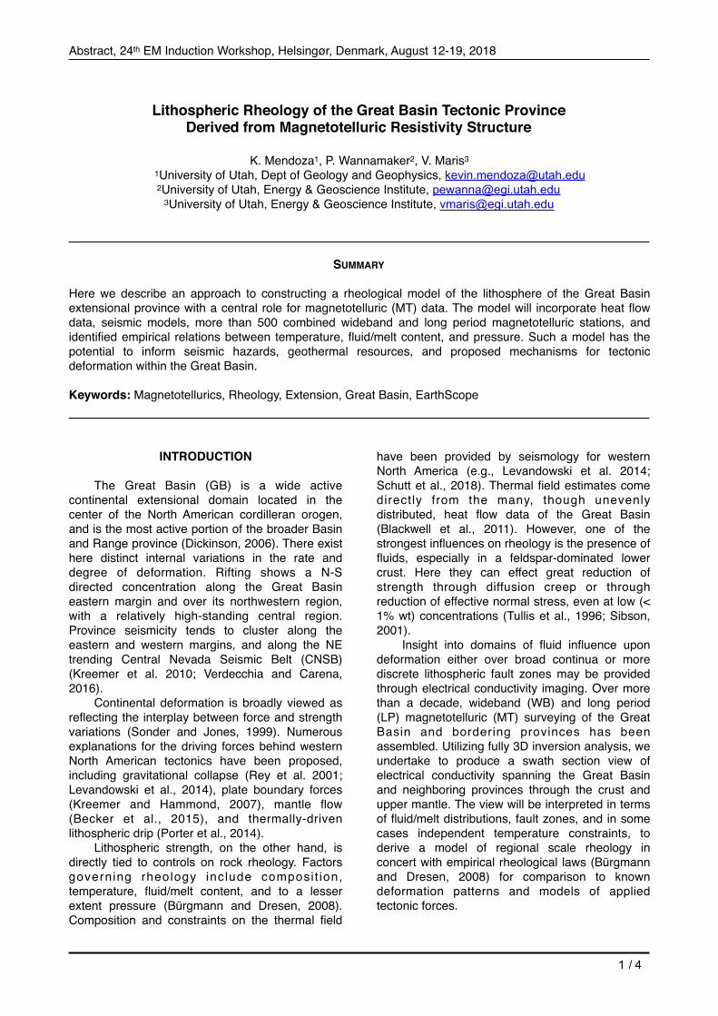
The centerpiece of our MT data set is a well-sampled profile trending ~east-west of length ~1200 km (Figure 1). It is made up of 397 WB (~0.01 – 500 s period) plus 68 LP (~10 – 104 s) soundings. This period range suffices to resolve resistivity structure from depths of a few hundred m through the upper mantle (410 km depth extent). For lateral control and to help produce a more swath-like resistivity model section, an additional ~80 LP MT sites are integrated using a combination of the MT campaign of Wannamaker et al. (2008) and the Earthscope MT TA array in this region (Meqbel et al., 2014).
Constraints on thermal regime are available from the many heat flow measurements compiled by Blackwell et al. (2011). Moreover, Schutt et al.
(2018) provide estimates of Moho temperature across the region from regional Pn velocity variations. Thermal conditions in the upper mantle have been interpreted based on regional S and P wave tomography (Goes and Van der Lee, 2002). All of these data sets will be checked for internal consistency.
Data Analysis
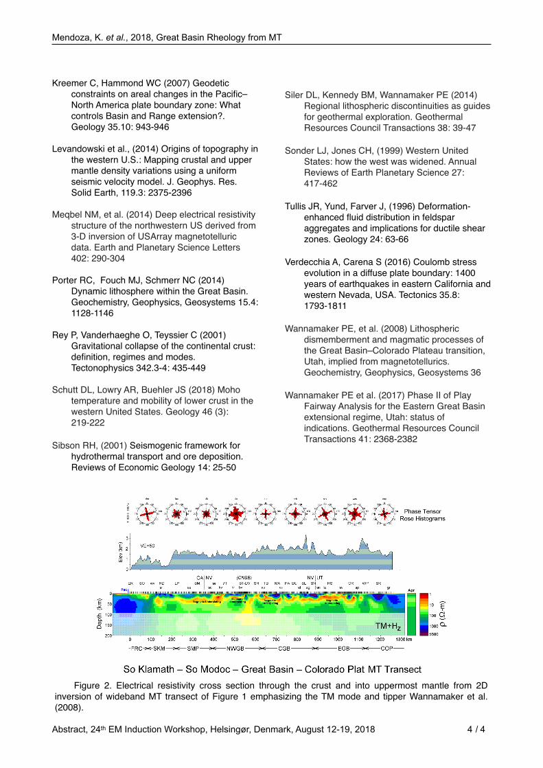
The central MT sounding transect was positioned to maximize the accuracy of a 2D structural assumption with respect to horst-graben morphology, modern extension directions, and province boundaries. Two-dimensional inversion analysis to date has considered only the WB component of the data which is sensitive to structure to a depth of ~70 km. Utilizing the transverse magnetic (TM) mode of impedance plus the tipper element Kzy (where x is assumed strike) an initial 2D resistivity cross section through crustal depths has been derived using the finite element algorithm (see Figure 2).
Principal among the structures resolved are a series of quasi-tabular conductors at deep crustal levels across the entire Great Basin. These lie at particularly shallow average levels in western Nevada and western Utah, where intensity of extension is relatively high. Based on geotherm and seismic velocity constraints, these conductors are interpreted to reflect basaltic magmatic underplating and hydrothermal fluid release (Wannamaker et al., 2008; Siler et al., 2014).
A primary analysis goal going forward is to produce a fully 3D resistivity model in a swath-like format by utilizing all components of the MT response for both the transect and the off-line LP control sites. For this, the MT data will be inverted using the HexMT algorithm developed by our group (Kordy et al., 2016a, b). This algorithm provides excellent inversion convergence through use of al l direct solvers and is able to accommodate the commonly steep topography through deformable hexahedral elements. Although inversions incorporating ~300 sites have been run by us on a single-chassis, multi-core workstation with 0.5 TB RAM (e.g., Wannamaker et al., 2017), this is a larger data set which may require WB site subsampling or local lateral averaging to fit into available resources. However, a 3D analysis will provide a clear measure of the variation along presumed strike of underplating zones, lithospheric-scale faulting, and possible melt zones in the upper mantle.
The heat flow data base described in Blackwell et al. (2011) will be modeled assuming steady state conditions. Independent estimates of temperature can be provided by exploiting the
Abstract, 24th EM Induction Workshop, Helsingør, Denmark, August 12-19, 2018 / 2 4
Figure 1. Digital elevation model map showing the distribution of wideband (green line) and long-period MT soundings (blue for U Utah acquired, orange for Earthscope) included for the study area. Also labeled are the Walker Lane (WL), Central Nevada Seismic Belt (CNSB), Intermountain Seismic Belt (IMSB), and US States. The following Geologic Provinces are included: Klamath Block (K), The Cascades (C), Sierra Nevada (SN), Modoc Plateau (MP), Colorado Plateau (CP), Great Valley (GV).
Mendoza, K. et al., 2018, Great Basin Rheology from MT
reasonably established correlation between the top of the lower crustal conductors and the 500 C isotherm (Wannamaker et al., 2008).
Fluid domains and temperatures resolved using MT and other geophysical data combined with deformation mechanism maps in Bürgmann and Dresen (2008) will be used to define variable strength 'zones' below this swath of the Great Basin and marginal provinces. This should be a considerable improvement over the lower crustal viscosity estimates of Schutt et al (2018) due to limitations of seismic methods in imaging small fluid concentrations. Zones of lithospheric weakness will be compared to extension rates across the province (Hammond et al., 2014). These data should allow us to compare whether plate boundary, gravitational potential energy, or other forms of force distributions are more compatible with observed strength patterns.
CONCLUSIONS
Multiple deformation mechanisms have been proposed for the Great Basin extensional province. Many aspects of applied forces can be estimated from surface observables, however variations in lithospheric strength are not entirely evident from current geophysical studies. The sensitivity of electrical conductivity to fluid/melt presence can allow domains of rheological diffusion creep to be defined. We propose to develop a rheological model by analyzing a comprehensive MT data set spanning the entire Great Basin tectonic domain. This model will be compared to geodetically and geologically estimated strain rates across the province for compatibility with various force models. As this analysis continues, these data will better constrain proposed mechanisms for deformation and seismicity within the Great Basin.
ACKNOWLEDGEMENTS
The campaign MT data of this project and their analysis so far have been supported under U.S. Dept of Energy contracts DE-AC07-95ID13274, DE-PS07-00ID13891, DE-FG07-02ID14416, DE-FG36-04GO14297, and DE-EE0006732 and U.S. N a t i o n a l S c i e n c e F o u n d a t i o n g r a n t s EAR02-30027, EAR08-38043 and EAR08-43725 to P. Wannamaker. Earthscope MT TA data were acquired under IRIS subcontract 75-MT to Oregon State University. We acknowledge Quantec Geoscience Inc. for acquiring high-quality wideband MT data. The long period MT instruments for the campaign data were borrowed from the University of Washington (John Booker, P.I.) through the NSF-supported EMSOC national MT pool.
REFERENCES
Becker, TW, et al. (2015) Western US intermountain seismicity caused by changes in upper mantle flow. Nature 524.7566: 458
Blackwell, et al. (2011) Temperature at depth maps for the conterminous US and geothermal resource estimates: Geothermal Resources Council Transactions 35: 1545-1550
Bürgmann R, Dresen G (2008) Rheology of the lower crust and upper mantle: Evidence from rock mechanics, geodesy, and field observations. Annual Review of Earth and Planetary Sciences 36: 531-567
Dickinson WR (2006) Geotectonic evolution of the Great Basin. Geosphere 2: 353-368.
Goes S, Van der Lee S (2002) Thermal structure of the North American uppermost mantle inferred from seismic tomography. Journal of Geophysical Research: Solid Earth 107: ETG 2-1-ETG 2-13
Hammond WC, Thatcher W (2005) Northwest Basin and Range tectonic deformation observed with the Global Positioning System. 1999-2003. Journal of Geophysical Research 110: B10
Hammond WC, Blewitt G, Kreemer C (2014), Steady contemporary deformation of the central Basin and Range Province, western United States, Journal of Geophysical Research, Solid Earth 119: 5235–5253
Kordy M, et al. 3-D (2016a) Magnetotelluric inversion including topography using deformed hexahedral edge finite elements and direct solvers parallelized on SMP computers–Part I. Geophysical Journal International 204.1 74-93
Kordy M, et al. (2016b) 3-dimensional magnetotelluric inversion including topography using deformed hexahedral edge finite elements and direct solvers parallelized on symmetric multiprocessor computers–Part II. Geophysical Journal International 204.1 94-110
Kreemer C, Blewitt G, Hammond WC (2010) Evidence for an active shear zone in southern Nevada linking the Wasatch fault to the Eastern California shear zone. Geology 38.5: 475-478
Abstract, 24th EM Induction Workshop, Helsingør, Denmark, August 12-19, 2018 / 3 4
Mendoza, K. et al., 2018, Great Basin Rheology from MT
Kreemer C, Hammond WC (2007) Geodetic constraints on areal changes in the Pacific–North America plate boundary zone: What controls Basin and Range extension?. Geology 35.10: 943-946
Levandowski et al., (2014) Origins of topography in the western U.S.: Mapping crustal and upper mantle density variations using a uniform seismic velocity model. J. Geophys. Res. Solid Earth, 119.3: 2375-2396
Meqbel NM, et al. (2014) Deep electrical resistivity structure of the northwestern US derived from 3-D inversion of USArray magnetotelluric data. Earth and Planetary Science Letters 402: 290-304
Porter RC, Fouch MJ, Schmerr NC (2014) Dynamic lithosphere within the Great Basin. Geochemistry, Geophysics, Geosystems 15.4: 1128-1146
Rey P, Vanderhaeghe O, Teyssier C (2001) Gravitational collapse of the continental crust: definition, regimes and modes. Tectonophysics 342.3-4: 435-449
Schutt DL, Lowry AR, Buehler JS (2018) Moho temperature and mobility of lower crust in the western United States. Geology 46 (3): 219-222
Sibson RH, (2001) Seismogenic framework for hydrothermal transport and ore deposition. Reviews of Economic Geology 14: 25-50
Siler DL, Kennedy BM, Wannamaker PE (2014) Regional lithospheric discontinuities as guides for geothermal exploration. Geothermal Resources Council Transactions 38: 39-47
Sonder LJ, Jones CH, (1999) Western United States: how the west was widened. Annual Reviews of Earth Planetary Science 27: 417-462
Tullis JR, Yund, Farver J, (1996) Deformation-enhanced fluid distribution in feldspar aggregates and implications for ductile shear zones. Geology 24: 63-66
Verdecchia A, Carena S (2016) Coulomb stress evolution in a diffuse plate boundary: 1400 years of earthquakes in eastern California and western Nevada, USA. Tectonics 35.8:1793-1811
Wannamaker PE, et al. (2008) Lithospheric dismemberment and magmatic processes of the Great Basin–Colorado Plateau transition, Utah, implied from magnetotellurics. Geochemistry, Geophysics, Geosystems 36
Wannamaker PE et al. (2017) Phase II of Play Fairway Analysis for the Eastern Great Basin extensional regime, Utah: status of indications. Geothermal Resources Council Transactions 41: 2368-2382
Abstract, 24th EM Induction Workshop, Helsingør, Denmark, August 12-19, 2018 / 4 4
Figure 2. Electrical resistivity cross section through the crust and into uppermost mantle from 2D inversion of wideband MT transect of Figure 1 emphasizing the TM mode and tipper Wannamaker et al. (2008).


![Effects of lithospheric viscoelastic relaxation on the ...1. Introduction [2] The effects of viscoelastic loading and relaxationof the Earth’s lithosphere are key elements in post-and](https://img.pdfslide.us/doc/110x75/5f0845417e708231d4212df6/effects-of-lithospheric-viscoelastic-relaxation-on-the-1-introduction-2-the.jpg)