Embed Size (px)
Citation preview

GILearner
Creatingalearninglineonspatialthinking
LITERATUREREVIEWONSPATIALTHINKING
LucZwartjesMaríaLuisadeLázaroKarlDonertIsaacBuzoSánchezRafaelDeMiguelGonzálezElżbietaWołoszyńska-Wiśniewska

GILearner 2
Content1 BACKGROUND...................................................................................................................3
2 GI-LEARNERPROJECT........................................................................................................6
3 WHATISSPATIALTHINKING.............................................................................................7
4 BACKGROUNDOFSPATIALTHINKING............................................................................10
5 SPATIALTHINKINGTOGEOSPATIALCRITICALTHINKING...............................................145.1 Spatialthinking–criticalthinking........................................................................................145.2 Geospatialcriticalthinking...................................................................................................155.3 Participationandspatialcitizenship.....................................................................................18
6 INTEGRATINGGISASTOOLFORGEOSPATIALCRITICALTHINKING...............................206.1 GISineducation...................................................................................................................206.2 IntegratinggeospatialthinkinginGIScienceforsecondaryschoolstudentsusingGIS.......276.3 CreatingGISlearningoutcomesthrougheducation............................................................296.4 Someinitiativesongeospatialcriticalsmartthinkingforstudentsatschool......................32
7 TAXONOMYINITIATIVESTOEVALUATESPATIALTHINKINGCOMPONENTS.................34
8 ALEARNINGPROGRESSIONLINEONSPATIALTHINKING..............................................378.1 Learningprogression............................................................................................................378.2 Learningline.........................................................................................................................378.3 Adraftlearninglineongeospatialthinking.........................................................................39
9 CONCLUSIONS.................................................................................................................43
10 REFERENCES................................................................................................................44

GILearner 3
1 BACKGROUNDGeo-ICT ispartof thedigitaleconomy identifiedby theEuropeanCommissionasbeingvital forinnovation, growth, jobs and European competitiveness. As a rapidly growing business sector,thereisaclearandgrowingdemandforGeo-ICTknow-how(DONERT,2015).
The use of GI tools to support spatial thinking has become integral to everyday life. ThroughmediaagenciesthatuseonlineinteractivemappingandnearubiquitouslyavailabletoolslikeGPSand car navigation systems, the general public has started to become aware of some of thepotentialofspatialdata.
Spaceandlocationmakespatialthinkingadistinct,basicandessentialskillthatcanandshouldbelearned in school education, alongside other skills like language,mathematics and science. Thegoal of GI-Learner is to integrate spatial literacy, spatial thinking and GIScience into schools.BEDNARZ&VANDERSCHEE(2006)madethreerecommendationsforthesuccessfulintroductionandintegrationofGIScienceinschools.Thesewereto:
• addresskeyinternalissuesrelatedtoGISimplementation:teachertraining,availabilityofuserfriendlysoftware,ICTequipmentinschools.
• useacommunityoflearnersapproachand• institutionalize GIScience into curricula, making sure that it is aligned with significant
generallearninggoalslikegraphicacy,criticalthinkingandcitizenshipskills.
In terms of the first two recommendations considerable progress has already been made, forexample there have been more training opportunities for teachers as the EduGIS Academy(http://www.edugis.pl/en/), iGuess (http://www.iguess.eu), I-Use (http://www.i-use.eu) andSPACIT (http://www.spatialcitizenship.org)projects.Schoolsnowadaysgenerallyhavebetter ICTequipment,pupilsareaskedbringtheirowndevices,dataismorefreelyavailableandWeb-basedplatformshavereducedcosts.Thedigital-earth.eunetworklaunched‘CentresofExcellence’in15Europeancountries(http://www.digital-earth-edu.net).TheGeoForAllinitiativehasdevelopedanetworkofOpenSourceGeospatialLabsaroundtheworldandhasalsofocuseditsattentiononschool education (http://geoforall.org/). These initiatives have helped build capacity for acommunityofpractitioners,inEuropeandbeyond,bycollectinganddisseminatinggoodpracticeexamples andorganizing sessionswith teachers.However, there are still needs formuchmoretraining,additionallearningandteachingmaterials,goodpracticeexamplesandacomprehensiveandwell-structuredcompilationofdigital-earthtools.
The institutionalization of geo-technology and geo-media into curricula still remains a goal inalmostallcountries.Ithasbyandlargenotbeenachieved,despitethedevelopmentof:
• benchmarks (HERODOT 2009; LINDNER-FALLY & ZWARTJES 2012), intended to give arationaleandrecommendationsontheimplementationtoteachertrainers,teachersandheadmasters,butalsotopolicyanddecisionmakers
• competencemodels(SCHULZEetal.,2012,2013,2015,GRYLetal.,2013),• teacher guidance (ZWARTJES, 2014) whereby teachers can select suitable tools to use,
basedoncurricula,abilitiesoftheirstudentsandtheirowncapabilitiesand• EuropeaninnovativeprojectslikeiGuess,SPACIT,EduGISAcademy,I-Useetc.
GI-LearneraimstorespondtothisbythedevelopmentofaGISciencelearninglineforsecondaryschools,sothat integrationofspatialthinkingcantakeplace.This impliestranslatingthespatial

GILearner 4
andother competences, taking into account age and capabilities of students, into real learningobjectivesthatwill increasespatialthinkingeducationactivitiesandhelpproducetheworkforceweneednowandforthefutureandgeospatiallyliteratecitizens.
The present work responds to the spatial thinking literature and how it turns into geospatialthinking.Itwilldevelopastateofarttakingintoaccountapsychologicalpointofview,aswellasdifferentspatialapproachesthatweimplementonthosestages:
• Spatialthinking• Criticalthinking• UsingGISandmakingsmartquestionsforageospatialcriticalthinking.
All of this will help us to create a learning line showing the importance of geospatial smartthinking.
The GI Learner project will develop teaching and learning material for this aim, as well as anevaluation on learning outcomes of the students who use these materials. The followingconceptualmapdevelopsthemainpointsofthiswork:

GILearner 5
Source: Spatial Thinking dimensions and related terms based on NRC, 2006 and other authors.OwndrawnM.L.LázaroandI.Buzo
GILearner 6
2 GI-LEARNERPROJECTGI-Learner(http://www.gilearner.eu) isaprojectsupportedbyKeyAction2oftheErasmusPluseducationprogram.It isathree-yearproject,withsevenpartnersfromfiveEuropeancountries.GI-Learner aims to help teachers implement learning lines for spatial thinking in secondaryschools,usingGIScience.Inordertodothis,theproject:
• summarizesthemostimportantliteratureonlearninglinesandspatialthinking• scanscurriculainpartnercountriestoidentifyopportunitiestointroducespatialthinking
andGIScience• definesgeospatialthinkingcompetencies• developsanevaluativetestonanonlinetooltoanalysethe impactofthe learning lines
ongeospatialthinkingand• creates initialdraft learning linestranslatingtheminto learningobjectives, teachingand
learningmaterialsforthewholecurriculum(K7toK12)
Itisenvisagedthatbytheendofthefirstyearoftheproject,pupilsfromagegroupsK7andK10ofthepartnerschoolswillpilotthematerialsandgivetheirfeedback.Thediagnostictoolwillalsobedeveloped,tested,assessedandrevised.GI-Learnerlearningoutcomeswillthenbere-writtenintoafinalversionandpublished.FurthermaterialsforlearninglineswillthenbedevelopedforyeargroupsK8,K11andK9,K12respectivelyinthesecondandthirdyearsoftheproject.Finally,apublicationwithguidelinesforsuggestedinclusionintothenationalcurriculawillbeproduced.
As part of the project, GI-Learnerwill create a tool to help learners evaluate their own spatialthinkingability,asadvocatedbyCHARCHAROSetal.(2015).Thepurposeandcontentofthistoolcould be adapted to meet the specific needs in terms of participant target group their age,gender, ethnicity or other aspects. The geospatial abilities to be examined can be selected,whethergeospatialthinkingabilityistobeevaluatedinaholisticorpartialway.

GILearner 7
3 WHATISSPATIALTHINKINGSpatial thinking is integral to everyday life.With the use of onlinemapping tools, GPS and carnavigation the general public has become aware of the possibilities of spatial data. And thedifferentconceptsofspacemakespatialthinkingadistinctformofthinking,whichhelpsstudentsto visualize relationships between and among spatial phenomena (STOLTMAN & DE CHANO,2003). It is a basic and essential skill that can and should be learned, besides other skills likelanguage,mathematicsandscience.
TheTheoryofMultiple Intelligences (GARDNER,1983,2006)distinguishesspatial intelligenceasone of the nine intelligences. Although spatial intelligence provides the ability to solve spatialproblems,inGardner’smodelitismainlyrelatedtoartssubjects.Geography,asascience,mainlyfocusesonspatialanalysisanddealswithspatialthinkingandthestagesoftheKolb’sexperientiallearningmodel(1984):plan,do,observeandthink.
Onekeypublication is theNATIONALRESEARCHCOUNCIL (NRC2006)report: ‘LearningtoThinkSpatially:GISasaSupportSystemintheK-12Curriculum’.Itdefinesspatialthinkingasthreelines:knowledge, tools and skills, and habits of mind, “a collection of cognitive skills comprised ofknowingconceptsofspace,using toolsof representationandreasoningprocesses”. It isexactlythe links among these three that gives spatial thinking its power of versatility and applicability
(Figure1).
Figure. 1. Spatial Thinking dimensions and related terms according to NRC, 2006.Drawnby:Michel&Hof(2013)
LEEandBEDNARZ(2006)describespatialthinkingasaconstructivecombinationofthreemutuallyreinforcing components: the nature of space, themethods of representing spatial information,andtheprocessesofspatialreasoning.Spatialthinkingisthecatalysttoimproveunderstandingofsubjects across the curriculum and as a way of thinking that crosses disciplinary boundaries(BEDNARZ,2005).
GOODCHILD (2006) argues that spatial thinking is oneof the fundamental formsof intelligenceneededtofunctioninmodernsociety,it isabasicandessentialskillwhosedevelopmentshouldbepartofeveryone'seducation, like learninga language,numeracyandmathematics.Studentsneed to know the building blocks of spatial thinking. It includes models, graphics, charts,photographs, 3D modelling, video and other multimedia tools. Geographers apply spatialintelligence to education. There have been many attempts to analyse, organise, classify anddefinethem.Theremainderofthissectionexaminessomeofthekeyliterature.
TheCOMMITTEEONSUPPORTFORTHINKINGSPATIALLY(2006)suggestspatialthinkinginvolvesbreakingtheprocessdownintothreecomponenttasks:extractingspatialstructures,performing

GILearner 8
spatial transformations, and drawing functional inferences. They explicitly stated that “Spatialthinkingusesrepresentationstohelpusremember,understand,reason,andcommunicateaboutthe properties of and relations between objects represented in space”. Their report definesspatial thinking as the ability to understand spatial relationships, the knowledge of howgeographicspace isrepresented,andtheabilitytoreasonandmakekeydecisionsaboutspatialconcepts. They suggest these skills are essential as they cut across many school subjects. Thechallengeistointegrateitintolearninginallappropriatecontentareas.HESPANHAetal.(2009)lookatexamplesofspatialthinkingfromasocialsciencesperspective.TheydiscussinsightsandstrategiesthatemergedfromaseriesofNSFworkshopsintheUSA.Theydiscusstheimportancein creating an environment for learning to think spatially, where a learner-centred approachbuilds knowledgeand teachers createsenvironments for knowledge construction. They suggestthisisbasedonpriorknowledgeandskillsaswellasindividualdifferencestomaketheconceptsappear more relevant and accessible. They recommend a number of strategies for assessingcontentknowledge,spatialconceptsandskills.
The realworld and its spatial representation helps us to understand cadastral charts, CommonAgricultural Policy maps and use location-based services (LBS) as well as other civic spatialengagementpractices (collectinganddiffusinggeospatialdataandparticipation in theanalysis)whicharenecessaryskills forcitizens (HAKLAY,2012).ThustheSpatialThinkingapproach isnotonly based on Geographical Information Education (GI Education) and labs but also on usinghuman,appliedandsocialgeography tosolvespatialproblems,and for thiscritical cartographyand spatial citizenship skills are necessary. A solid foundation in spatial literacy will providestudentswith thecrucial scientificandsocialquestionsof the21st century (TSOUandYANOW,2010).
Spatial thinking has been a common element in all Earth system sciences, such as Geography,Geology and Environmental Sciences. It is also prevalent in other disciplines, such as Business,Marketing,ScienceandsomeareasofMathematics.Spatialthinkingisalsoacatalysttoimprovethe understanding of subjects across the curriculum and as a way of thinking that crossesdisciplinary boundaries (DONERT, 2015). Geospatial technologies can be used to ask or helpanswerdifferentsortsofspatialquestion,developspatialskillsandimprovetheabilitytoreasonspatially.Thiscanberelatedtomanydifferentstudyareasinschools.
Developingthespatial thinkingcapabilitiesofstudentshelpsfostergeographicskills,knowledgeandunderstanding.KERSKI(2008)summarizesitastheabilitytostudythecharacteristicsandtheinterconnectedprocessesofnatureandhumanimpactintimeandatappropriatescale.TSOU&YANOW (2010) consider how spatial perspectives assist students in discovering the value ofgeographic knowledge and develop their ability to explore and visualize real-world, criticalproblemssuchasglobalclimatechange,naturaldisasterrecoveryandresponses,andwatershedconservation.Theysuggestthatwithasolidspatialfoundation,studentswillbebetterpreparedtoconsiderthecrucialscientificandsocialquestionsofthe21stcentury.
Spatial thinking strengthens students' abilities to conduct scientific inquiry, engage in problemsolving,andthinkspatially.Studentsneedtoknowthebuildingblocksofspatialthinking.These,according to SCHULTZ et al. (2008), may either be expressed in general spatial terms such assymmetry, isomorphism, reflection, orientation, rotation, and function, or those based on aparticular discipline, such as relative versus absolute distance, small versus large scale, anddistancedecayingeography.Tothisend,theNATIONALACADEMYOFSCIENCES(2006)proposedfive skill sets, asking geographic questions, acquiring geographic information; organizing

GILearner 9
geographic information; analysing geographic information; and answering geographic questions(Figure2).
Figure2:GeographicInquiry:ThinkingGeographically(ESRI,2003)

GILearner 10
4 BACKGROUNDOFSPATIALTHINKINGResearchbychildpsychologistsconfirmthatareasofthebrainaredevotedtodifferentkindsofspatial thinking and that these seem todevelop in very early childhoodand that these tend toaccumulate through life. As NEWCOMBE and FRICK (2010) state, spatial intelligence hasevolutionaryandadaptiveimportance.Anymobileorganismmustbeabletonavigateinitsworldto surviveandmust represent the spatial environment inorder todo so. So spatialorientationandknowledgeabouttheenvironmentaroundisknownasaprimaryspaceuse(ROBSON,2012).Thedevelopmentprocessofspatialcompetencescanbenoticedfromveryearlychildhoodanditcontinuesintoschoolage(BULLENSetal.,2010).
ROBSON(2012) identifies threemainstagesof thespatial competencedevelopment, related tothewaywerepresentspatiallocation:
• egocentricrepresentation:inrelationtoourselves,andourownposition;• landmarkrepresentation:inrelationtolandmarksintheenvironment;• allocentric representation: by use of an abstract frame of reference, including use of
maps,orcoordinates,
As infantsweunderstand a space in egocentricway, putting ourselves in the centre.However,researchshowsthatevenbabiesagedthree to fourmonthsunderstandtheconceptsofabove,below, left and right (QUINNetal., 2011).Whenbabies start toexplore theworldby crawling,they also activate process of cognitive mapping, developing mental maps of the spatialenvironment around them. By the age of eighteen months children commonly use landmarkrepresentation. They are able to use characteristic points in the surrounding to reorientthemselves (BULLENS et al., 2010), even if that means necessity to link few mental mapsdevelopedearlier.
Asresearchersclaimtheallocentricrepresentationofspatiallocationcanbeseenamongchildrenofone-year-old.By theageof4childrenareable tousesimplemaps to find theirwayaround.They interpret different symbols representing specific objects in the real world (roads, rivers,etc.).Theyalsostarttousecoordinates,forexampleonasimplegrid(ROBSON,2012).
Changes in the representation of spatial location are strongly related to so called secondaryspatial use – construction of the maps. As mentioned by ROBSON (2012), children start withsimpleschematicdrawingswherethingsareseenfromthesideratherthanfromabove,throughthemixingbothplan (objects seen fromaboveand from the side), finally to themost complexapproach including abstract representation of objects with clearly defined spatial relations.Childrenfollowthisdevelopmentalpathastheybecomemoreawarewithunderstandingoftwoimportant issues– first, thatamap isonlya representationofa realworld,and secondly,howlayersshownonamaparerelatedtorealworld.Researchshowthatchildrenaged3appreciatetherelationsbetweenmapsormodelsandtherealworld(NEWCOMBE,FRICK,2010).
Spatial behaviours look very different during infancy, childhood, and adulthood – there can belittle debate about that among psychologists (LIBEN, 2006). However, and what is particularlyinteresting,isthatthereisrelativelylittleagreementaboutwhethertheage-linkeddifferencesinobserved behaviours signify qualitative differences in the way that space is represented andthoughtabout,ordotheyonlysignifyquantitativechangesinothercognitiveskillsorstructures

GILearner 11
(e.g., changes in speed of processing). Therefore, probably, different models of spatialcompetencesdevelopmentcanbeproposed.
GERSMEHL and GERSMEHL (2006, 2007, 2011) examined the neuroscience research that dealswithdistinctmodesofspatialthinking'describedinresearchaboutadultspatialcognition.Theirpapers were based on a detailed review of neuroscience research observing how areas of thebrainare related to thekindsof "thinking" thatappear tobedone.They conclude that severalbrainregionsappeartobedevotedtodoingspecifickindsofthinkingaboutlocationsandspatialrelationships. They advised that “durable learning of geographic information is more likely tooccurwhenlessonsareexplicitlydesignedto"force"studentstoperformaspatialtask,thatis,touseoneormoreofthedistinctmodesofspatialthinkingthatappeartobeatleastpartially"hard-wired" into the human brain.” They confirmed that students would greatly benefit if spatialthinking skills was more prominently placed in the school curriculum including in early yearseducation.
After their study (Table 1) on different modes of spatial thinking GERSMEHL and GERSMEHL(2011) concluded that “Students who are proficient with one kind of spatial thinking, such asspatial association, areoften less able todoother kindsof spatial reasoning, andvice versa. Ingeneral, females tend to score better on tests that involve spatial associations,whereasmalesseemtodobetterwithtasksthatinvolvespatialsequencingormentalrotation”.
Table1:ModesofSpatialThinking(GersmehlandGersmehl,2011)
Location—Whereisthisplace? a.Conditions(Site)-Whatisatthisplace? b.Connections(Situation)-Howisthisplacelinkedtootherplaces?
EightaspectsofSpatialThinking(anexampleofaconcreteactivity)
1.Spatialcomparison -Howareplacessimilarordifferent?Howcanwecomparethemfairly?Canwecompareplacesbyexaminingmaps?(e.g.arrangemodelsofthecontinentsin order of size, location of desks in the classroom, verbal comparisons of rooms in theschool)2. Spatial influence (Aura) - What effect(s) does a feature have on nearby areas? Theabilitytorecognizewhatis“nearspace”and“farspace”foraspecificpurpose.(e.g.agamethatrequiredtheuseofthewordsnextto,near,closetoandfarfrom)3. Spatial groups (Region) - What nearby places are similar to each other and can begrouped together? it is possible to draw a line around them on a map or on a satelliteimage.(e.g.dividetheclassroomintoregionswithsimilarfeatures–deskareas,playareas,readingareas,andsoforth;drawpicturesofthescenestheyhadseenonatripandputthepictures into groups– placeswhere people live, placeswhere people shop, placeswherepeopleworship,placeswherepeoplegotohavefun,andotherplaces;workwithlandusemaps)4.Spatialtransition-Isthechangebetweenplacesabrupt,gradual,orirregular?(slopes,gradients,sequences).(e.g.toaskstudentsiftheyknowofaplacewhereitishardtowalkorpullawagonbecausethelandgoesuphill,torecognizeplaceswithdifferentrainfall)5. Spatial hierarchy - Where does this place fit in a hierarchy of nested areas? (e.g. Apolitical map provides an easy-to-understand example: municipality, province or countyandcountry).6.Spatialanalogies-Whatdistantplaceshavesimilarsituationsandthereforemayhave

GILearner 12
similar conditions? The importance of similarity of position, however, extends beyondmapping. (e.g. to “putyourbook in the samepositiononyourdeskasmybook isonmydesk.”)7. Spatial patterns - Are there clusters, strings, rings, waves, other non-randomarrangements of features? The human brain has been described as a “pattern-seekingmachine. (e.g.describeandanalyse thespatialpatternsofreal-worldphenomenasuchasearthquakes,malls,orsettlements). Theanalysisofspatialpatternsisanendinitself.Onthecontrary,itusuallyservesasapreludetothelastofourmodesofspatialreasoning,theanalysisofspatialassociations.-8. Spatial associations (correlations) -Do features tend to occur together (have similarspatial patterns)? It tries to understand causal relationships. (e.g. asked tomake lists of“thingsthatareusuallyfoundtogetherinthesameroom,liketoothbrushesandtoothpaste,orbooksandcomfortablechairs”;makeamapoftheirclassroom,weaskedstudentstotrytonamethingsthatgotogetherinthesamepartoftheroom,likedesksandchairs.
Spatio-temporal thinking - How do spatial features change through time?Change-changeinconditions(e.g.climate,militarycontrol, landuse,etc.)ataplaceovertimeMovement-changeinpositionofsomething(e.g., train,hurricane,border,etc.)overtimeDiffusion-changeinextentofsomething(e.g.,disease,urbanarea)overtime.
ResearchonspatialthinkinghasbeencomparedbyISHIKAWA(2016),seeTable2.
Table2:Comparisonwithotherstudies’geospatialconcepts(Ishikawa,2016)
AnotheroverviewofspatialconceptframeworkscanbefoundinSOLEMetal.(2014)inTable3.

GILearner 13
Table 3: Spatial Concepts Frameworks (Mohan, Mohan & Uttal, mentioned in Solem et al., 2014)

GILearner 14
5 SPATIALTHINKINGTOGEOSPATIALCRITICALTHINKING
5.1 Spatialthinking–criticalthinkingSpatial thinking traditionally was linked to spatial visualization and orientation (McGEE, 1979;PELLEGRINOandKAIL,1982), to spatialperceptionandmental rotationas integration in spatialvisualization (LINNAND PETERSEN, 1987); to spatial relations, associations and spatial patterns(GILMARTIN and PATTON, 1984; SELF et al, 1992; ALBERT and GOLLEDGE, 1999). LEE andBEDNARZ(2009and2012)restatethatspatialthinkingislinkedtospatialvisualizationinordertoget a better interpretation of patterns of entities of the territory framework (associations,relations,connectionsorhierarchies).
SCHULZEetal.(2013)analysedthemajordimensionsconnectedwithspatialthinkingduringtheSpatial Citizenship project. They extracted and described seven interconnected competencies,criticalthinking,geography,GISknowledgeandskills,problemsolving,spatialthinking,teamworkandcollaborationandvisualisationandcommunication(Table4).
Table4:Domainsconnectedwithspatialthinking(afterSchultzetal,2013)
JOHNSON and SULLIVAN (2010) stated that spatial thinking will play a significant role in theinformation-basedeconomyofthe21stcenturyandBEVINGTON-ATTARDIandRICE(2015)addedthat technological transformations and changes due to newmapping tools andnew sources ofdata, are altering educational aims and innovation contexts improving data analysis, dataexploration,anduserexperience.KERSKI (2008a)comments thatspatial thinkinghelpsusmakesenseofspatialpatterns,linkages,andrelationships.
KERSKI (2008b) summarizes spatial thinking as the ability to study the characteristics and theinterconnectedprocessesofnatureandhumanimpactintimeandatappropriatescales.Infact,thisisrealgeography:beabletothinkcriticallyabouttheearth,theactivitiesofpeopleandthe
GILearner 15
interactionbetweenthetwo.Thinkingspatially ismorethanknowingwherethingsare located,it’saboutaskinggeographicquestions:whythere,howoriginatedandwhatif...
BEDNARZ and LEE (2011) concluded in presenting their spatial thinking ability test (STAT) thatspatial thinking is not a single ability but comprised of a collection of different skills, wherebyfollowingspatial thinkingcomponentsemerge:mapvisualizationandoverlay, identificationandclassificationofmapsymbols (point, line,area),useofBooleanoperations,mapnavigationandrecognitionofspatialcorrelation.
Geodataqualityandadequaterepresentationallowscriticalthinkingtobebuiltin.Keyquestionsand assessment features with clear guidelines facilitate this (RUSSEL, 2013) and critical spatialthinking.Theassessmentofthesourcesusedcanhelptoestablishacriticalapproachtoterritory.Inourdailylivesdirectobservationonterritoryisawaytolearnandbuildspatialthinking,butwecan improve it with other ICT or GI (Geographic Information) technology tools in order tocomplete a spatial perspective. Critical thinking generally emphasizes the reflective evaluationprocesses regarding information, argument, and knowledge (KIM and BEDNARZ, 2013). Spatialquestioningstrategiesareveryimportantinitsdevelopment(JO,BEDNARZ,andMETOYER2010).
Critical perspectives of spatial thinking are addressed by GOODCHILD & JANELLE (2010). Theymakethecasethatplacehasemergedasanimportantcontextualframeworkforcertaincriticalsocietalissues.So,theyargueconceptsofspaceandplace,andspaceandtimeshouldbecentralthemesineducation,aspartofafundamentalshiftfromdisciplinarytomultidisciplinarysystems.Theterm‘critical’isdescribedasareflectiveandanalyticalapproach,whichcanberelatedtotheways spatial tools and data are used to generate questions and provoke critical thinking. Theysuggest critical spatial thinkers will be able to recognise and understand the assumptions andlimitations underlying spatial data, its representation and reasoning associatedwith it. Spatialtechnologiesareperceivedasanessential,integratingelementthatcutacrossdisciplinesthroughcommonlanguageandconcepts.
Criticalityiscentraltoengagement,participationandaction.Itisrelatedlydirectlytoconceptsofspatialcitizenship(GRYLetal.,2010).Theconceptofspatialcitizenshipwasdevelopedas‘smart’spatialthinkingbecauseitincludes:i)deconstructionofspatialinformationfromvarioussources;ii)establishmentofpersonalvisionsofsocialspaceandiii)translatingandcommunicatingthesevisionswiththehelpofgeoinformation.Geo-mediaisusedinaspatialcitizenshipcontexttohelpacquire instrumental knowledge and help find solutions to problems and understand morecomplexissues.Web2.0developmentsactivelypromotetheimportanceofgeo-participationandgeo-communication.
5.2 GeospatialcriticalthinkingKOUTSOPOULOS (2011) proposed an epistemological change had taken place in geographicdisciplines, which is developing into a new scientific praxis, labelled by MORENO (2013) as ageotechnological-definedparadigm,asanewwayofdoingscience.Thisisnotonlyderivedfromtechnological advances, but also because of the huge increase in spatial data (big data,miningdataandcrowdsourcingdata,amongothers)availabletocitizenswhoseknowledgeonqualityofdatanowappearstobeessential(KERSKI,2015).Thisscientificparadigminspirestheproperuseoftechnologies,whichinGeographycanbetranslatedintoGIStechnologiesasascience,notonlyas an applied tool (teaching GIS) but for learning, teaching and researching: teachingwith GIS(KOUTSOPOULOS, 2010). COOK et al. (2014) describe this as strategic spatial thinking,which isuseful fordrawingupplansorprogramsdesignedforachieving futuregoalsandusingavailable

GILearner 16
resources. Developing a strategy enables the design of approaches that will help meet futurechallenges. This stipulates preparation and anticipation to reach an ideal but possible state.Therefore, how changes take place is decisive. Participatory processes are being increasinglyencouraged, often based on visual access to knowledge that stimulates and develops attitudesand shapes participative behaviours leading to collective commitment (WANNAPA and SUPOL,2012).
A geospatial focus, according to ROCHE (2014) includes not only geographical scales (local,municipal,regional,nationalandinternational)andspatialanalysisandresearch,butalsoexplicitGIScienceandtools.ThisisnotverydifferentfromthedefinitionofspatialthinkingproposedbytheNRC(2006).Geographicskillsprovidenecessarytoolsandtechniquestothinkspatially.Theyenable us to observe patterns, associations, and spatial order. As described, “Geographicrepresentations ... are essential because they assist in visualizing spatial arrangements andpatterns”(NATIONALGEOGRAPHYSTANDARD,2012).
KING (2006) draws attention to the fact that developing geospatial literacy is important and itshouldbebasedoncertainspatial skills,whicharenotpractical skills thatcanbeeasily taught,butthattheseskillsexistaspartofthestudentengagementinalearningprocess.Thissequenceofspatialcompetencesincludes:
• spatialorientation(the‘where?’component)• thinkingandacting(whereisitinrelationto?)• thespatialprocess(orwhatchangesaretakingplace?)• thespatialsystems(orhowaretheybeingaffected?)• thewiderissues(orhowdoesitconnectbeyond?)• makingdecisions(orwhichsolutionsarethere?)and• howcanImakeadifference?DONERT (2008)suggests thesespatial skills shoulddriveanactive learningpedagogywheretheexploration (of places) happens, measurements (associated with location) are collected,observations (of places) are made, information (about places) are attached to place marks,journeysandtoursbasedonmaps.ThesecouldbedescribedasbaselinecomponentsofstrategicspatialthinkingasCOOKetal(2014)assume.
SpatialanalysisandresearchwithGIScienceconnectsspatialproblemsandspatialrelationstotheEarth’ssurfaceanditsrepresentationonconventionalordigitalandinteractivemapsinordertosolve them (HUYNN and SHARPE, 2013). This requires the development and use of geospatialskills. LOBBEN and LAWRENCE (2014) organize this in a very similar way to Gersmehl andGersmehl (table 1)with prime geospatial skills categories as: Location, Identity andMagnitude(includingallspatialaspects)andTime.
Therefore, explicit GIScience methods and tools, linking reality with maps and technologies(Figure 3), geographic information, Global Navigation Satellite Systems (GNSS, such as theAmericanGPSor in the future theEuropeanGalileo) andGIS areessential critical components,with important elements such as quality of geodata (geospatial data: aerial, satellite orcrowdsourced)andinteroperabilityasfundamentalgeospatialfeatures.
All of them needs a smart focus, such as learning and acting smart, it means intelligent,personalizedandsignificant.Itissupportbysmartdevices(phonesortabletsamongothers)butalsoforhumanswhotakethebestservicesfromdevices.

GILearner 17
Figure3:GISciencemethodsline.ItsaimistolinkEarthrealityandvirtualrealityforspatialanalysisinordertoachievetheabilitytosolvespatialproblemsbasedoncorrectandwisedecisions(Lázaro,2015).
The topics and competencies necessary to help acquire critical and smart geospatial thinkingneedsalsotobereviewed.AlthoughGISciencemethodsareessentialforlearning,someyearsagoteachers’experiencesdidn’talwaysconcurwiththispointofview.WehavesummarizedresultsofseveralteachersusingGIScienceatschoolinTable5.
Table5:GIScienceforlearning(Lázaro,2016)
Author Year GIScienceexperienceresults
Abbott Albert andGolledge
2001
1999
There are not many differences between students using GIS andthosewhodonot.
Kerski 2000 Better results and skills to encapsulate, identify and discoverterritorialelements.
Hagevik 2003 Itdevelopsvisualizationskillsandspatialterritorialthinking.
Patterson, ReeveandPage
2003 Candevelopstudents’ critical spatial thinking (manyotherauthorsagree:Wigglesworth, 2003; Liu and Zhu, 2008; Milson and Curtis,2009).
Lázaro andGonzález
2005 ThepotentialofGIStoolsforlearningiscoming
National ResearchCouncil/Committee onSupport forThinkingSpatially
2006 GIS had a clearly demonstrated potential as a support system forspatialthinking.
Kidman andPalmer
2006 Thetechnologyistherebuttheteachingisyettocatchup.
Demirci 2009 Teachers in Turkey have developed a favourable attitude towardsGIS, although they are still seeking opportunities to use it in theirgeography lessons. However, the study indicates that still need toovercomeanumberofobstaclesrangingfromlackofhardwareandsoftwaretotheirlackofknowledgeandskillsaboutGIS.
Lietal. 2010 GISandPBLdevelopanalyticalandevaluationskillsofstudents.
Favier and VanderSchee
2012 Improve learningbasedonresearchprojects,althoughteacherandstudenttrainingisnecessarytoachievelearningtasks.
KimandBednarz 2013 Improvecriticalspatialthinkingthatcurriculapromote.
Buzo 2014 Students get actively involved in the learning process using

GILearner 18
technology,openingadifferentwindowto theworldofknowledgeanddigitalskills.
DeMiguel 2014 Improve critical thinking, motivation and functionality of learningtools.
Esteves H.M. &RochaJ.
2015 Itfostersignificantlearningwithtoolsthatarealsoavailableintheworld outside classrooms and that are being used by students intheirdailylife.
5.3 ParticipationandspatialcitizenshipIn schools GIS is often linked to computers and technical interests (HARVEY, 2014). Learningprocesses and knowledge strongly oriented towards technical interests largely producesinstrumentalknowledge.GRYLetal.(2010)commentonhowtheuseofGISatsecondaryschoollevel is predominantly used a support tool to encourage spatial thinking, but it should also beimplemented to assist the development of citizenship. They suggest that this perspective isimportantasstudentscanacquireamuchbroadersetofcompetenceswithGI-basedlearning.
GRYLetal.(2010)recommendthreemainfieldsofcompetence(Figure4)andfurtherdevelopedinTable6.
• technicalandmethodologicalcompetencestodealwithspatialinformation• competencestoreflect/appraise/evaluatespatialrepresentationsand• competencestoactivelyengagewiththespatialdimensionsofsocietyandcommunicate
meaningusingspatialinformationinaninformedway.
Figure4:CompetencesforSpatialCitizenship(Gryletal.,2010)
Table6:DevelopingCompetencesforSpatialCitizenship(afterGryletal.,2010)
Technical / methodological competences include i) map reading, orientation and navigation,findingone’splaceandidentifyingadestination,ii)theabilitytolabelafeature,markandratea place or feature of interest, comment on alternative spatial scenarios; iii) contribute one’sowndataandiv)analyseandanswersimplequestionsandfulfilsingle-stepanalyticaltasks.
Thecompetencetoreflect,appraiseandevaluatespatialrepresentationsconcernsknowledgeaboutgeomediaconstruction;recognitionofspecificrepresentations;comparisonofgeomedia

GILearner 19
information order to detect limitations; deconstruction to identify intentions in the use ofgeomediafrommultipleperspectives.
Thecompetencetoactivelycommunicateandparticipateconcernsconstructionofaprocessofmeaningwhich involves democratic negotiation; expression by finding a way to convincinglycommunicate meanings; communication to share ideas and meanings for adoption; anddialogue to engage in, discuss, stand-up for and re-negotiate. This is an iterative non-linearprocess,whichactivelyusesgeomediatofurtherinterestsindemocraticdecisionmaking.
Theconceptofspatialcitizenship(ibid)wasdevelopedas‘smartspatialthinking’toaddressthisbecause it includes: i) the deconstruction of spatial information from various sources; ii) anestablishmentofpersonalvisionsofsocialspaceandiii)beingabletotranslateandcommunicatethese visions with the help of geoinformation asWeb 2.0 developments actively promote theimportanceofthesegeo-participationandgeo-communicationskills(Figure5).Spatialcitizenshipeducationisthusaboutlearninghowtonavigateourworldinrespecttoa)thephysicalworld,b)the meanings attached to physical objects and the environment and c) the power relationsinvolvedintheproductionofmeaning.
Figure5:Spheresofactivities/rolesregardinggeoinformation(Gryletal,.2010)
GIS,usedinaspatialcitizenshipcontext,encouragesinstrumentalknowledgetobeacquired,butalso helps find solutions to problems and understand more complex issues. GRYL et al. (ibid)advocateforamoreparticipativeapproachtousingGISinschooleducation,onethatexploresthecompetencesneededforactiveandcriticalparticipationinsocietyusingspatialmedia.

GILearner 20
6 INTEGRATING GIS AS TOOL FOR GEOSPATIAL CRITICALTHINKING
6.1 GISineducationMapping can be an effective method for communicating large volumes of data to others.However, theeffectivenessofcommunicationwithmaps isdependentonthespatial literacyoftheobserver (CLAGETT, 2009).GISplays an important role in acquiringGeographic InformationLiteracy. Sharing geographic literacy (knowledge about geography) with information literacy(information search strategies, critical evaluation of sources) leads to Geographic InformationLiteracy (Figure 6): the possession of concepts, abilities, and habits of mind (emotionaldispositions)thatallowanindividualtounderstandandusegeographicinformationproperlyandtoparticipatemorefullyinthepublicdebateaboutgeography-relatedissues(MILLERandKELLER,2005).
Figure6:Contextualdiagramforgeographicinformationliteracy(MillerandKeller,2005)
WhenreferringtoGIStheterm‘GeographicInformationSystem’ismostlyused,definedasasetofcomputertechnologiesthatallowvisualizingandmanipulatingofgeodatainaneasygraphicalmethod.ButGIShasalsobeencalled‘GeographicInformationScience’(GOODCHILD,1992),thusalso involving scientific methods and approaches of looking at and understanding the world(MILSON,2012),wherebyGISisusedtohelpobtainspatialthinkingskills.
FREEMAN (1997) stated ‘changes in technology pervade the pedagogy and methodology ofgeography’ so with the possibilities offered to use GIS nowadays (free software, availabledatasets,computerswithinternetcommon)wecannowlongerignoretheuseofitineducation’.KOUTSOPOULOS(2010)mentionstwoapproachesforusingGISineducation:
• WecanusethepowersofGIStoteachgeographyforitcanhelpusunderstandourworldthrough both the natural and the man-made manifestations which are the essence ofgeography.
• In teaching with GIS a positive effect can be created on the development of spatialthinkingandreasoning.
THOMPSON (1991) suggests that GIS is an ‘educational delivery system for improving thestudent’sknowledgeoftheworldinwhichsheorhelives.’GISisabletoanswerallthequestions

GILearner 21
that knowledge, understanding and application in geography education requires(KOUTSOPOULOS, 2010). Thus ‘GIS can be defined as the study of the fundamental issues ofgeographic information,and isoftenmotivatedby theneed to improvegeographic informationtechnologies’(GOODCHILD,2011).
Becauseof itscapabilities,GIS is inherentlyanexcellentvehicle inexpressingthefivethemesofgeography,asdefinedbyTHEJOINTCOMMITTEEONGEOGRAPHICEDUCATION(1984): location,place, relationships with places, movement and region. NIELSEN et al. (2011) advocate for astand-alone K–12 curriculum for geospatial technology and spatial thinking and discusses itsdevelopment in an experimental teacher education institution. The focus of the coursewas inbuildingstudents’knowledgeandskillsingeospatialtechnologies,makingstudentteachersawareof their spatial thinking skills, offering opportunities to use tools to solve community issues.They start by not using technologies, including readings and sequencing and strategy games.Through this they develop an initial understanding of spatial thinking by reflecting, observing,comparing,andpracticingspatialthinkingskills.Theythenlearnedtousegeospatialtechnologies,sourcesofdataandtransformingprimarydataintomapsandothergraphicalrepresentations,GISandGPSfollowedandthenusingtheguidelinesofESRI’s“CommunityAtlas”,studentscreatedageneral atlas of the community. After evaluation, they recommended a coursewith prescribedactivities,foundationalconceptsandsimpleskills,whichthenrequiresstudentstodesignareal-world project that investigates their community. The latter gives students control of theireducationandfostersanenvironmentoflearningthatwillservethemwell.
Ahabitofmindcanbedescribedasthebroadestlearningoutcomewhichissometimesbasedonwaysofthinking.KIMandBEDNARZ(2013)usedthistoidentifyanddefinedfivesubdimensionsofspatial habits ofmind. Thesewerepattern recognition, spatial description, visualization, spatialconceptuse,andspatialtooluse(Table7).
Table7:Fivespatialhabitsofmind(afterKimandBednarz,2013)
PatternRecognition
studentsshouldbetaughtandencouragedto foster their spatial habits to recognizepatternsintheireverydaylife
extension: “recognize, describe, andpredictspatialpatterns”
SpatialDescription
Students can use spatial vocabularyproficiently
extension: a more advanced spatiallexicon and more frequent use ofspatialvocabulary
Visualization Students increase understanding throughtheaidofgraphicalrepresentations
extension:enhancecomprehensionbyconverting the information intovisualrepresentations, understand thebenefit and power of graphicrepresentations
SpatialConceptUse
Students use or apply spatial concepts tounderstandandperformvarioustasks
extension: employ spatial concepts tounderstandsurroundings
Spatial ToolUse
Students use spatial representations andtoolstosupportspatialthinkingexposureto tools helps understand space and
extension: spatial thinkers usingspatialtoolstosolveproblems

GILearner 22
developspatialcognition
KIMandBEDNARZ (ibid) then created an inventory tomeasure these sub-dimensions (Table 8)and tested it to assess whether the development of Spatial Habits of Mind can be enabledthroughGISlearning.
Table8:Aspatialhabitsofmindinventory(KimandBednarz,2013)
NEWCOMBEandSHIPLEY(2015)identifiedfiveclassesofspatialskillsonwhichtrainingresearchhas been done to classify spatial abilities (Table 9). They identified an intrinsic-static skill(disembedding), two intrinsic-dynamic skills (spatial visualization and mental rotation), oneextrinsic-staticskill(spatialperception)andoneextrinsic-dynamicskill(perspectivetaking).Theyenvisagethisprocess

GILearner 23
Table9:Organisingspatialskills(NewcombleandShipley,2015)
TSOU and YANOW (2010) consider General Education undergraduate courses, where themaingoalistoequipstudentswithaspatialliteracyfoundation(includingspatialawarenessandspatialand quantitative reasoning methodologies) so students can discover the value of geographicknowledgeanddeveloptheirabilitytoexploreandvisualizereal-world,criticalproblemssuchasglobalclimatechange,naturaldisasterrecoveryandresponses,andwatershedconservation.
They argue thatwith a solid foundation in spatial literacy, studentswill be better prepared toconsiderthecrucialscientificandsocialquestionsofthe21stcenturyandsuggestedaneducationmodel with fivemajor teaching components to support the learning objectives effectively andprovidepedagogicalguidelinesforteaching(Figure7).
Figure7:AconceptualeducationmodelofGISandTechnologyforgeneraleducation(TsouandYanow,2010)
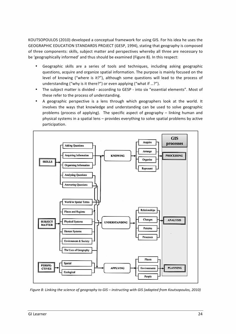
GILearner 24
KOUTSOPOULOS(2010)developedaconceptualframeworkforusingGIS.ForhisideaheusestheGEOGRAPHICEDUCATIONSTANDARDSPROJECT(GESP,1994),statingthatgeographyiscomposedof threecomponents:skills, subjectmatterandperspectiveswherebyall threearenecessarytobe‘geographicallyinformed’andthusshouldbeexamined(Figure8).Inthisrespect:
• Geographic skills are a series of tools and techniques, including asking geographicquestions,acquireandorganizespatialinformation.Thepurposeismainlyfocusedonthelevel of knowing (“where is it?”), although some questions will lead to the process ofunderstanding(“whyisitthere?”)orevenapplying(“whatif…?”).
• Thesubjectmatterisdivided-accordingtoGESP-intosix“essentialelements”.Mostoftheserefertotheprocessofunderstanding.
• A geographic perspective is a lens through which geographers look at the world. Itinvolves the ways that knowledge and understanding can be used to solve geographicproblems (process of applying). The specific aspect of geography – linking human andphysicalsystemsinaspatiallens–provideseverythingtosolvespatialproblemsbyactiveparticipation.
Figure8:LinkingthescienceofgeographytoGIS–instructingwithGIS(adaptedfromKoutsopoulos,2010)

GILearner 25
Geographic skills, subject matter and perspective correspond to the processes of knowing,understanding and applying: by “learning the concepts and vocabulary of geography (knowing)studentsmaybegintothinkaboutwhattheymean(understanding)andapply torealproblems(applying)” (NAEP GEOGRAPHY CONSENSUS PROJECT, 2010). Knowing is in spatial termsexpressedby thequestions ‘What is it?’and ‘Where is it?’, inGIS thismeansprocessingspatialdata.Understanding isexpressedbyquestionssuchas: ‘Why is it there?’, ‘Whathaschanged?’,‘What is the pattern?’, ‘What is the interaction?’, in GIS this is spatial analysis. Applying isexpressedbythequestion‘Whatif...?’tosolvespatialproblems,inGISthismeansplanning.
KOUTSOPOULOS (2010) then linked the three GIS processes with the questions and the fivethemesofgeography–createdbytheJOINTCOMMITTEEONGEOGRAPHICEDUCATION(1984):location,place,relationshipwithplaces,movement,andregion(Figure9).
Figure9:AconceptualframeworkinInstructingaboutGIS(adaptedfromKoutsopoulos,2010)
HisframeworkshowsveryclearlytheimpactandimportanceofGISinansweringthequestionsonthe level of the threeprocesses.He results that “GIS can serve as auniqueeducational tool in

GILearner 26
which themanipulation, analysis and presentation of spatial data can support the teaching ofgeography”(KOUTSOPOULOS,2010).
More specifically, typical spatial thinking skills are enhanced using GIS. By involving studentactivitiesusingGIS“studentsnotonlylearnbyhearingandseeing,theyalsohavetheabilityandopportunitytopersonallyapplytheknowledgeusinghigher-orderskillssuchasproblemsolvingandsynthesis”(SANDERS,2002)Inordertofostersuchskillsteachersandstudentsmayneedtoworkinnewwayssuchasthroughenquirybasedmethodsandproblem-basedlearning.
TheapproachdevelopedbyKoutsopoulosfollowsoneofthefourGISschoolsdescribedbyKEMP(1992,quotedinSUI,1995,Figure10):GISasanenablingTechnologyforScience,arguingthatGISisnotagoalinitselfbutameanstousespatialthinkingskills.
Figure10:Fourschoolsofthoughtabouttherelationshipbetweengeography&GIS(Kemp.etal,mentionedbySui,1995)
Twoofthefourschoolsdescribetheidealvisionforsecondaryeducation:• ThefirstschoolsstatingthatGeographyisuniquelysuitedasthehomedisciplineofGIS.It
simplyautomatesthetasksgeographershavebeendoingforseveralthousandsofyears,andaimsatafullintegrationofGISintoallaspectsofgeographycurriculum.
• ThethirdschoolseeingGISas thetool tosupportscientific inquiryasultimategoal inavarietyofdisciplines,thusGISisasenablingtoolforscience.
Bothputtheemphasisofthecoursecontentonapplication–GISasatool,whereasthetwootherschoolsarefocusingonthetechnicalaspectsofGIS.
Generallyspeaking,geospatialtechnologiescanbeusedtoaskoranswerdifferentsortsofspatialquestion,which can be related tomany different study areas. It helps foster geographic skills,knowledge, and understanding by developing the spatial thinking capabilities of students. TheprevalenceofGIStechnologyisthusasolutiontotheneedtodevelopspatialskillsandbeingabletoreasonspatially.
ItisthismultiplefunctionalitythatmakesGISanexcellentcomponenttolearnaccordingtheTPCKframeworkasdescribedbyMISHRAandKOEHLER(citedbyFAVIERetal,2012):‘theknowledgeateacher should have about how to use technology in instruction in such a way that studentsdevelop knowledge and skills in a certain domain’. The TPCK framework is addedwith theGIScomponentinhisGIS-TPCKframeworkapproach(Figure11).

GILearner 27
Figure11:ThegeneralTPCKmodel(left)andtheGIS-TPCKframework(Favieretal.,2012)
6.2 Integrating geospatial thinking in GIScience for secondary schoolstudentsusingGIS
The introduction of GIS in education has been argued by three complementary rationales thatcorrespondtoGIS’sstrengths:
• The educative rationale: GIScience and GIS support the teaching and learning ofgeography.
• Theplace-basedrationale:GISistheidealtooltousetostudygeographicalproblemsatarangeofscales.
• Theworkplacerationale:GISisanessentialtoolforknowledgeworkersinthetwenty-firstcentury.
VANLEEUWENandSCHOLTEN(2009)seeanaddedvalueofusingGISbasedonfivesenses:• Senseofreality:usingrealisticdata–e.g.oftheownenvironment-makesabstractspatial
theoriesbecomereal• Senseofurgency:byusingrealisticdataandthematicitemsstudentsgetinterested.• Sense of experience of having influence: using GIS students get the opportunity to
visualizeatodaysandtomorrowslandscape,influencedby(their)owndecisions• Senseof fun:people learnmoreeasilywhentheyareenjoyingwhattheyaredoingand
usingGISisfunwhenthetoolsareeasy,interestingdataisavailableandthecasestudyisexiting.
• Sense of location: by using GIS in combination with GPS routes, tracking and tracinggamesordoingfieldworkgivesanextradimension,location(x,y,zcoordinates)becomesanexcitingthingtoexplore.
These arguments have not appealed to large numbers of teachers however. According theresearchofBEDNARZandVANDERSCHEE(2006)themainreasonsare:
• Inteachertraining(pre-serviceandin-service)GISisnotacoreitem.

GILearner 28
• Non-geographers, leading to teachers with limited pedagogical content knowledge,resulting in fewer teachers recognizing the potential opportunities GIS offers to teachgeographycontentandskills,teachmoreandmoregeography.
• Thecurriculumdoesn’tincludeorimpedeadoptiontoincludeGIS.• Theavailabilityoffreedataandeasy-to-usesoftware.• Theattitudeofteachers.Itseemsdifficulttopersuadeteacherstousenewtechnologies,
certainlyiftheyarehighlytechnicaldemandingandifteachersarenotfullyconvincedoftheeffectivenessandaddedvalue.
Theymadethreerecommendations,1. Address the key internal issues related to GIS implementation: teacher training,
availabilityofuserfriendlysoftware,ICTequipmentinschoolsThiswasamatterofdevelopingeasiertousesoftwarewithdataaccess.AsGOODCHILD(2011)concludesinhisanalysisofGISsoftwareprograms:“theGISuserinterfaceremainscomplex, hard to learn anduse, and lacking in any consistent conceptual or theoreticalframework.”Alotofprogresshasbeenmade.TherearefreeGISviewers(noneedtoinstallsoftware)oropensourcefullGISsoftwareprogramsavailable.Schoolsarenowadayswellequippedwith computersandahigh speed (mobile) Internet.Asa resultof the INSPIREdirectivemore andmore governments areofferingdatasets (for free) or provideopen access todatabase servers. In different countries specific educational GIS-frameworks have beendeveloped, like EduGIS in the Netherlands (VAN DER SCHEE et al., 2006), thePairform@nceProjectinFrance(GENEVOIS,2011)orPaikkaOppiinFinland(Houtsonenetal.: 2014). These learning environments offer a simplified viewer – mostly inside abrowser–withcontentthatfitsintotheexistingnationalcurriculum.
2. Useacommunityoflearnersapproach.A community of learners means bringing together within a school or school region allinvolvedandcrucialstakeholdersintheeducationalprocess.Togethertheyreflectandactuponbestpractices.Althoughthisisamuchpraisedandeffectivemethod,realityshowsthatcertainlyinsecondaryeducationthisisnotalwaysworking.TheDigital-Earth.eunetworkhaslaunchedinmanycountries‘CentreofExcellence’.Thesecentreswillhelpbuildingupthecommunityofgeomedialearners,e.g.bycollectinganddisseminatinggoodpracticeexamples,organizinginformalsessionswithteachers.
3. InstitutionalizingGIS intocurricula,makingsurethat it isalignedwithsignificantgenerallearninggoalslikegraphicacy,criticalthinkingandcitizenshipskills.This is alsomentioned by The National Academy of Science (DOWNS et al. 2006) whostatedasoneof theprimordially recommendations thedevelopmentof spatial thinkingstandardsandcurriculummaterial.
FAVIER(2013)describes fivewaysonhowGIScanbe integrated insecondaryeducation(Figure12).TeachingandlearningaboutGISfocusesmoreonthetheoreticalaspectsofGIS(knowledgeofGIS,structureof thetechnology),wherethethreeotherwaysusethetechnologytodevelopandusespatialthinkingskills.

GILearner 29
Figure12:FivewaysofintegratingGISingeographyeducation(Favier,2013)
Researchshowsthatmost‘successful’andeasiestintegrationofGISisdonein‘InvestigatingwithGIS’,wherestudentsareaskedtodoarealgeographicenquiry.LIUandZHU(2008)explainthisbylinkingGIStoconstructivism.Geographyenquirydrawsonconstructivism,emphasizingproblem-solvingand inquiry-based learning insteadof instructional sequences for learning content skills.And GIS provides useful tools for constructing a computer-based constructivist-learningenvironmentforgeographyeducation.
Without questioning the importance of this we must nevertheless try to generate a morecontinuous integration of GIS in education, using all fiveways. The Irish pilot project ‘GIS intoschools’isagoodattempttocreateandtestcurriculummaterialsforteachingGISprinciplesandpractice (TSCHIRNER and O’BRIEN, 2006). They indicate – just like KOUTSOPOULOS (2010) andFAVIER(2013)-toachieveanoverallintegrationofGISthatstudentsfirstneedtolearnaboutGIS(theory and practice) and then apply this knowledge to learnwithGIS. The Irish example usedseveralgeographycurriculabasedtopicsandisthusnotreallyintegratedoverthedifferentyearsofthecurriculum.
6.3 CreatingGISlearningoutcomesthrougheducationTheSpecial InterestGroup3oftheDigital-Eath.eunetwork(WOLOSZYNSKAetal.2013)seetheimportanceofintroducingGIS(useofgeo-media)forthreecompetences(Figure13):
• Personalcompetencies:Developing spatial literacy assumes interaction with geoinformation. A geographicapproach is necessary to answer questions critically and constructively. Therefore,teachersmust understand basic geographic concepts and be able to support students’learningneeds.Employabilityisenhancedbygeo-mediaskills.
• Socialcompetencies:Education for active citizenship equips people with the content knowledge, skills andunderstandingtoplayaneffectiveroleinsociety.Theybecomeinterestedincontroversialissuesandengaged indiscussion,debateanddecision-making.Therefore,education forspatial citizenship plays an important role for the learning process.To enable teachers to bridge the technological gap between students and themselves,theyneedtousegeo-mediaintheclassroomtoallowlearnerstoexplorerealworldissuesandencouragelifelonglearningstrategies.
• Professionalcompetencies:

GILearner 30
Geo-media brings the real world into the classroom. Constructive and active learningpractices like problem solving, project-based learning, fieldwork strategies and enquiryapproachesarefavouredandwillhelpthemtofacefuturechallenges.
Figure13:Whygeo-mediainteachertraining(Woloszynskaetal.2013)
Therefore,teachersmustunderstandbasicgeographicconceptsandbeabletosupportstudents’learning needs. Taking in account the different levels of age and education, teachers must beenabledtoapplydifferentmethodsandtoolsintherespectivelearningenvironments.
To help a benchmark has been developed1, indicating the competencies needed for spatialliteracy.
Competencies:
• Spatialthinkingo Toknowconceptsofspatialthinkingo Beabletousetoolsofspatialrepresentation,o To apply processes of reasoning (Where is it? Why is it there?What if it was
somewhereelse?Makinginformeddecisionsanddefendpersonalpointsofview)• Pedagogicanddidacticalskillsfortheuseofdigitalearthtoolsinschool• Abilitytousespatialskillsinrealworldproblem-solvingcontext• Understandingcomplexandchanginginterrelationships• Awarenessandunderstandingforthedigitalearthconcept• Abilitytousedigitalearthtools(alsotechnologicalskills)• Lifelong learningcompetencies:ability to findtrainingopportunities, timemanagement,
planningcompetency,communicationcompetencies
1This benchmark statement has been produced as a result of the digital-earth.eu COMENIUS network SIG 3 (Teacher education and teacher training) meeting in Brugge, Belgium in October 2011www.digital-earth.eu

GILearner 31
• Beingabletoidentifyandevaluateresources• Sociallearning:
o Beingabletoworkwithothers–teamworko Useprofessionalsocialnetworks(virtualandface-to-face)
In order to prepare teachers to effectively implement digital earth in their practice, teachertraining and teacher education needs to appropriately prepare teachers for different levels ofeducation.
Primaryschoolteachersneedtobeabletoenablestudents(year1-6)to
• Opendigitalmapsandvirtualglobesonacomputer• Indicate the different parts of digital maps/virtual globes (navigation bar, menu, scale,
mapwindow)• Interpretsymbolsondigitalmaps• Workwithdigitalmapsand3Drepresentationsoftheworld
o Findsignificantlocations(theirhome,schoolortown)onavirtualglobeo Pan,zoom,orientateo Makemeasurementso Usethelayerstofocusonspecificfeatureso Updatemaps
• Beawareofgeneralizationlevelsappliedindifferentzoomlevels(e.g.roaddensity)• Access information efficiently and effectively, evaluate information critically and
competently(seemapsasmanipulatedrepresentationscreatedbypeople/organizationswithacertainpurpose,e.g.classificationmethods,colourschemes,mapcontents)
• Usedigitalmapsandvirtualglobesforavarietyofdifferentpurposes
Secondaryschool(year7-12)
Inadditiontothelearningoutcomesofprimaryschool,secondaryschoolteachersneedtoenabletheirstudentsto
• Knowthedigitalearthconceptanditstools• Understandthebasicpurposeandapplicationofdigitalearthtorealworldproblems• Beabletogatherandevaluateinformation• Useadvanceddigital earth tools for learning (startingwithWeb-GIS,GIS viewers toGIS
software)• Manipulatemaps
o Displayinformationonmapso Createownmapso Communicatecartographicinformation
• Understandtheconstructionofdigitalmapsasarepresentationoftherealworldo Thepowerofmaps(reliabilityofdata,classificationandcolourschemes)o Topology:points,lines,polygonso Layerso Database
• KnowabouttheprofessionaluseofGISandotherdigitalearthtools• Gatherinformationfromdataresourcesorthroughfieldworkactivities(useGPSdevices,
mobileapplications)• Usedigitalearthtoolsforinvestigation/research

GILearner 32
o Interpretcontento Identifyandasksignificantquestionsthatclarifyvariouspointsofviewand lead
tosustainablesolutionso Frame,analyseandsynthesizeinformationinordertosolveproblemsandanswer
questions.
6.4 Some initiatives on geospatial critical smart thinking for students atschool
EmpiricalresearchthatexplicitlyexaminestheroleofGISinpromotingcriticalspatialthinkingislacking (HALL-WALLACE & McAULIFFE, 2002). Nowadays an increased number of studies andinitiatives around the world on geospatial critical and smart thinking have been created forsecondaryandhighschools.MILSON,DEMIRCIandKERSKI(2012)giveavisionof27countriesandafteracomparativestudyamong33countries(KERSKIetal,2013).
We can here stress some of the most recent and successful initiatives such as “GeospatialSemester” promoted by James Madison University, USA (KOLVOORD, 2012)(http://www.isat.jmu.edu/geospatialsemester),ortheFinnishexperienceofteachingandlearningusing the PaikkaOppi learning environment (http://www.paikkaoppi.fi/). The Finnish initiativeshows the suitability of the SpatialData Infrastructures (SDI) for school uses (Houtsonenet al.:2014). The main problem is to adapt the geodata information to visualisation adapted topedagogiccontent.GONZÁLEZ (2012)advises theuseofSDIandPBL in secondaryschoolsafterGRANEL,MANSOandotherswork(2009).LÁZAROetal(2015)improvetheideausingSignA,thenatural node of SDI in Spain, a GIS of the Spanish National Geographical Institute (Potti et al.,2011).
Active inquiry methods for outdoor activities can be used when learning geography with webmaps, throughnavigationandusing interactivemapsas storytellers. Theseare schoolpracticesidentifiedbyLÁZAROetal(2008,2013,2016),byBUZO(2014,2015)(Figure43andTable10)andbyDEMIGUELetal.(2015)withtheDigitalSchoolAtlasinitiativeandtheArcLessonsavailableon:http://atlasdigitalescolar.es.
Figure14:GIscienceforlearning(Buzo,2015)

GILearner 33
Table10:SpatialprojectsinIESSanRoqueSchool(Buzo,2015)
Programme 2013/14Year 2014/15Year
Innovation EducativeProjects
GISWeb in Geography(3rd year of secondaryschool)
Project Based Learning (PBL) forspatial thinking in Geography (2ndyearbachelor).
R&D and innovationSchoolPrograms
Environmental realityanalysis andimprovement proposalsinthetownofBadajoz.
Physical exercises in Badajoz publicspaces.
Social support networkand educative innovation:Extremadura network ofinnovativeeducation.
Spatial thinking as the foundation forscientificknowledge.
Asaresultoftheseandotherinnovativedevelopments,WOLODTSCHENKO(2012)suggeststhatthetraditionalmapshavelosttheirmonopolypositionincommunicatinggeospatialinformation,now sharing it with digital interactive cartography. In order to take advantage of criticalcartography, teachereducation isessential tosupportcriticalandsmartgeospatial thinkingandgeospatialliteracybasedonapedagogicalcontentknowledge.
GIStechnologiesareimportantinteachereducation,butforbuildingGIScienceforschools,anewapproachtospatialproblemsinthe21stcentury.TheresultsofSHIN,MILSONandSMITH(2015)indicatethatadditionalattention isneededtospatial thinking in teacherpreparationprograms.Theeffortsundertakento improvethepreparationof futuregeographyteachersshould includeexplicitattentiontospatialconcepts,spatialreasoningprocesses,andspatialrepresentations(JOandBEDNARZ2014).Furtherempiricalresearchisneededtoimproveteacher’seducationforthewider use of GIScience at schools. This does not mean teaching GIS, it means learning andteaching with GIS (FAVIER, 2013). KOUTSOPOULOS (2011) has stressed how useful GIS is inansweringquestionsonknowing,understandingandsolvingterritorialproblems.
The benchmark created by the Digital Earth projectwas a first step towards integrating GIS inschool and college education.When combining this with the concept of learning lines we canconstructthecontentdependingofthepupilage.Withinputfromothersthismightleadtoarealcurriculumreform(ZWARTJES,2014).

GILearner 34
7 TAXONOMY INITIATIVES TO EVALUATE SPATIAL THINKINGCOMPONENTS
JARVIS (2011)considers the termspatial thinking tobeaverybroadsubjectbut integral to theprocessofspatialliteracyacquisition.Inordertobringordertothetask,herinitialfocuswasonhighlyvisualandnon-mobilecontextsforspatialthinking.Todothissheexaminestheprocessofspatial literacy via spatial thinking dependant on three components, abilities, strategies andknowledge(Figure15).Fosteringanabilitytomakethelinksbetweenspace,representationandreasoning (or to think spatially) is central to spatial literacy.Shesays that Ineducational terms,thefactthatspatial literacy isso integraltoGeographyinparticularmayresult in itbeingbeingneglected.
Sheoffersameta framework forspatial literacy,adapted fromotherauthors, forGIScience. Interms of the types of representations, transformations and complex thinking, it includes i)Representations: The Properties of Entities; ii) Comparisons: The Relations Between StaticEntities; iii) Comparisons: The Relations Between Dynamic Entities; iv) Transformations ofRepresentations of Entities and v) Complex spatial reasoning: Combining components to solvequestions.
Figure15:Theprocessof,andconstituentpartsof,spatialliteracy(Jarvis,2011)

GILearner 35
JO and BEDNARZ (2009) developed a taxonomy to evaluate different components of spatialthinking in the curriculum, textbooks, lesson plans, and other instructional materials. Jo et al.(2010)use this toexaminequestioning in spatial thinkingaspartof everyday teachingpracticeapplied to the pedagogical strategy of questioning, in both texts and as part of classroomactivities.TheydevelopthisasBloom’sTaxonomydoesnotaddressmajorcomponentsofspatialthinking, namely concepts of space and using tools of representation, in its knowledge andcognitivedimensions.
The taxonomy (Figure16)uses three componentsof spatial thinking: (1) conceptsof space, (2)using tools of representation, and (3) processes of reasoning as primary categories. Thesubcategoriesdifferentiatevaryinglevelsofabstractionordifficulty(Table3).JOetal.(ibid)goontomakethecasethatthetaxonomyofspatialthinkingisausefultoolfordesigningandselectingquestionsthatintegratethethreecomponentsofspatialthinkingandfordeterminingthedegreeofcomplexityofaquestion inregardsto itsuseofspatialconceptsandthecognitiveprocessesrequired.
Figure16:Taxonomyofspatialthinking(JoandBednarz,2009)
SCHOLZ et al. (2014) use this system to identify the level and type of spatial thinking found intextbook questions as described in Table 11 and suggest a simplified taxonomy for evaluatingmaterialsintegratingallthreecomponents(Figure17).
Table11:Threecomponentsofspatialthinkinginquestions(afterScholzetal.,2014)
Component1:ConceptsofSpaceNonspatial:Nospatialcomponentinthequestion.SpatialPrimitives:thelowestlevelconceptofspace,involvestheconceptsoflocation,place-specificidentity,and/ormagnitude.Simple-Spatial:Ahigherlevelconceptofspace,basedonconceptsanddistributionsderivedfromspatialprimitives(Golledge1995)includingdistance,direction,connectionandlinkage,movement,transition,boundary,region,shape,referenceframe,arrangement,adjacency,andenclosure.
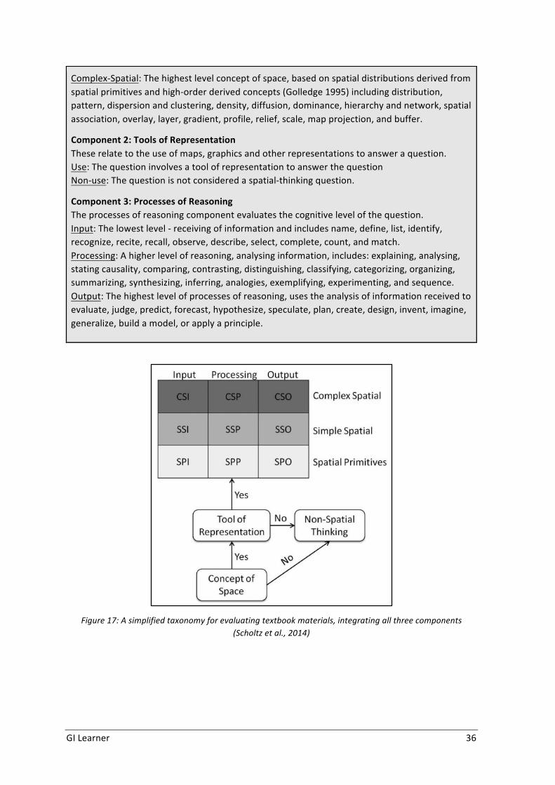
GILearner 36
Complex-Spatial:Thehighestlevelconceptofspace,basedonspatialdistributionsderivedfromspatialprimitivesandhigh-orderderivedconcepts(Golledge1995)includingdistribution,pattern,dispersionandclustering,density,diffusion,dominance,hierarchyandnetwork,spatialassociation,overlay,layer,gradient,profile,relief,scale,mapprojection,andbuffer.
Component2:ToolsofRepresentationTheserelatetotheuseofmaps,graphicsandotherrepresentationstoansweraquestion.Use:ThequestioninvolvesatoolofrepresentationtoanswerthequestionNon-use:Thequestionisnotconsideredaspatial-thinkingquestion.
Component3:ProcessesofReasoningTheprocessesofreasoningcomponentevaluatesthecognitivelevelofthequestion.Input:Thelowestlevel-receivingofinformationandincludesname,define,list,identify,recognize,recite,recall,observe,describe,select,complete,count,andmatch.Processing:Ahigherlevelofreasoning,analysinginformation,includes:explaining,analysing,statingcausality,comparing,contrasting,distinguishing,classifying,categorizing,organizing,summarizing,synthesizing,inferring,analogies,exemplifying,experimenting,andsequence.Output:Thehighestlevelofprocessesofreasoning,usestheanalysisofinformationreceivedtoevaluate,judge,predict,forecast,hypothesize,speculate,plan,create,design,invent,imagine,generalize,buildamodel,orapplyaprinciple.
Figure17:Asimplifiedtaxonomyforevaluatingtextbookmaterials,integratingallthreecomponents(Scholtzetal.,2014)

GILearner 37
8 ALEARNINGPROGRESSIONLINEONSPATIALTHINKING
8.1 LearningprogressionAlearningprogressionisdefinedas“descriptionsofthesuccessivelymoresophisticatedwaysofthinkingaboutatopicthatcanfollowoneanotheraschildrenlearnaboutandinvestigateatopicover a broad span of time (e.g., 6 to 8 years). They are crucially dependent on instructionalpracticesiftheyaretooccur”(NRC2007,219,citedbySOLEMetal.,2014).
Alearningprogressionshouldconsistoffollowingessentialfeatures(SOLEMetal.,2014):
1. thelearninggoalsorlearningtargets,basedonknowledge,skillsandabilitiesneededformakingthenextstepinunderstanding
2. thedevelopmentalprogressionsofthinkingandlearninginwhichstudentsmightengage,thisiswhatwecallthelearningline
3. assessments: tasks that allow students to reveal their reasoningabout the levels in thelearningprogress
4. (sometimes)learningactivitiesorsequencesofinstructionaltasks.
8.2 LearninglineLINDNER-FALLY & ZWARTJES (2012) defined a learning line as an educational term for theconstructionofknowledgeandskillsthroughoutthewholecurriculum.Itshouldreflectagrowinglevelofcomplexity,rangingfromeasy(morebasicskillsandknowledge)todifficultasillustratedintheFlemishcurriculumforsecondarygeography(Table12).
Table12:Learningline(Leerplancommissieaardrijkskunde,2010)
BLOEMEN&NAAIJKENS (2014) describe a ‘learning line’ as anoverall framework for educationandtraining,withadistinctsequenceofstepsfrombeginnerstoexperts.Theirlearninglinewasi)analytical; i.e. itdistinguishes indetail the skills, knowledgeandattitudeson several levels thatmaybeexpectedandii)competence-based;thelearninglinedistinguishesasetofcompetencesthattogetherbuildtheoverallcompetenceinthefield.Theydistinguishedeightcompetencesfortranslators,ofwhichsixwerecoreand twoperipheral;and five indicative levels;breakthrough,beginner,advanced,professionalandexpert.
VANMOOLENBROEK&BOERSMA (2013) describe the elaborationof a learning line for biologyeducation, using a concept-context approach for selecting learning goals and organizingknowledge.Theapproachrelatedscientificconceptstocontextstherebyimprovingengagementwith the science curriculum by selecting contexts that have relevance for the students. Theydecidedtoestablishaproblemposingapproachthattakesexplicitlyalearners’pointofview.
Level1 Perception–knowledgeoffacts
Level2 Analysis–selectionofrelevantgeographicinformation
Level3 Structure–lookforcomplexconnectionsandrelationships
Level4 Apply–thinkingproblemsolving

GILearner 38
PERDUEetal.(2013)proposedaspatialthinkingframeworkandhypothesizedthatcertainspatialthinkingskillsarehigherorderthanothersandbuilduponprevious,lesscomplexskills(Figure18).So, in theexampleshown, regional identification is conceptualizedasahigh level skill achievedthroughtheaccumulationofproximity,boundary,clustering,andclassificationskills.
Figure18:Spatialthinkingframework(Perdue,2013)
Learning lines imply a conceptual process of learner progression. However, YOUNG (2010)suggests these cannot be developed through generic curriculum approaches and they mustinvolveacurriculumthat isdrivenbycontentasthecarrierofconcepts,ratherthanpurelyonebased on skills and competences. GI-Learner focuses on geographical education, but takesaccountofnationaldifferencesincurricula.
Several authors try to use a learning line to integrate geographical inquiry processes (after DEMIGUEL,2016)–seetable13.
Table13:Learninglinesandgeographicalinquiryprocess(DeMiguel,2016)

GILearner 39
8.3 AdraftlearninglineongeospatialthinkingWhenapplyingthelearninglineconceptoftheLEERPLANCOMMISSIEAARDRIJKSKUNDE(2010)–seetable12-tothelearningoutcomes(describedintheprevioussection)wegetthisresult:
Level1:Perception-beingabletoworkwithdigitalmapsandvirtualglobes:
• Opendigitalmapsandvirtualglobesonacomputer• Indicate the different parts of digital maps/virtual globes (navigation bar,menu, scale,
mapwindow)• Interpretsymbolsondigitalmaps• Understand the construction of digital maps as a representation of the real world
(topology,layers,database)
Level2:Analysis–selectionoftherelevantgeographicinformation
• Work with digital maps and virtual globes: find locations, pan, zoom, orientate, makemeasurements
• Access information efficiently and effectively, evaluate information critically andcompetently
• Be able to gather and evaluate information from data resources or through fieldworkactivities
• Interpretcontent
Level3:Structure–lookforcomplexconnectionsandrelationships
• Usedigitalmapsandvirtualglobesforavarietyofdifferentpurposes• Identify and ask significant questions that clarify various points of view and lead to
sustainablesolutions• Manipulatemapsbycreatingownmaps• Communicatecartographicinformation
Level4:Apply–thinkingproblemsolving
• Beawareofgeneralizationlevelsappliedindifferentzoomlevels(e.g.roaddensity)• Understandthebasicpurposeandapplicationofdigitalearthtorealworldproblems• Useadvanceddigital earth tools for learning (startingwithWeb-GIS,GIS viewers toGIS
software)• Frame, analyse and synthesize information in order to solve problems and answer
questions
For introduction in the different grades of schools the level would depend of the age. Level 1shouldbereachedinprimaryeducation;level2canalreadybereachedinprimary–dependingoftheclassgroup -butmustbe reached in lowersecondaryeducation.Level3canbe reached inlowersecondary–againdependingoftheclassgroup,butmustbereachedtogetherwithlevel4inuppersecondaryeducation.

GILearner 40
Figure19:LearninglineonSecondaryschool
Another method which could be used is the cataloguing of the required competencies intocompetencyareasasthebasisforalearningline(WOLOSZYNSKAetal.2013)–table14,wherebyteacherswouldbeable tochoosesuitable tools touse,basedontheabilitiesof their students,theirowncapabilitiesandtheircurriculum.
Table14:LearningLine(Woloszynskaetal.2013)
CompetenceAreas
Primary6–10y
LowerSecondary11–14y(Inadditionto6-10y)
UpperSecondary15–18y(Inadditionto11-14y)
understanding/analysingdigitalgeomedia
reading,orientating,combining,interpreting,measuring,comparing,querying
geoprocessingnetworkanalysisspatialanalysis
producingandcommunicatingdigitalgeomedia
collaborativeactivities,mapping,visualising,sharing,discussingupdategeo-media,maps,infographics,charts,presentationscollectandrepresentinformationaddinformationtomapsandothergeo-mediathematicmapping…atdifferentlevelsofscaleandcomplexityovertheyears
critical use /awarenessofdigitalgeomediaineverydaylife
awarenessofgeneralization,differentzoomlevels,perspectives,intentions,manipulatedrepresentations,volunteeredgeographicalinformation(vgi)reflectoncontentandrepresentation,informationrightsandethicsidentificationofdigitalmediaineverydaylifegeomediaaspartofdecisionmaking
geographicaltechnology:hardware&tools
GPS,digitalmaps,virtualglobeswebmapping
3Drepresentationsoftheworld(DEM)satelliteimagesopengeodataonline,desktopandmobileGIS
IntheirresearchSOLEMetal.(2014)statethat“Everylearninglinehasbothaloweranchorandanupperanchor;theloweranchorrepresentstheemergingknowledgestudentshaveasnovicelearnersofaconstructorpractice,andtheupperanchor isadepictionofwhat learnersshouldknowandbeabletodoafter learninghasoccurred”.Toillustratethis,theygivetheexampleofhypothetical learning line on spatial aspects of a conflict (table 15),where they determine theupperandloweranchor.

GILearner 41
Table15:upperandloweranchorofahypotheticallearningline(ownwork,basedonSolemetal.,2014)
theme Upperanchor LoweranchorSpatialAspectsofConflict
• allstudentsgraduatingfromhighschoolneedtobeabletounderstandtherolethatresources,suchaswater,oil,andnaturalgas,playinconflictsaroundtheworld
• -Studentsmustbeabletounderstandnewsreportsandnewspaperarticlesonthetopicofworldwideresourceconflictsothattheycanbeknowledgeablecitizens—notexperts—onthetopic
• Theconceptsandskillsthelearningprogressionwillencompass(table16)
• determinetheagethatwouldmakethemostsensefortheloweranchoroftheprogression(table17)
Table16:Determiningtheconceptandskillsofthelearningprogression(Solemetal.,2014)

GILearner 42
Table17:Determiningthespatialconceptsoftheloweranchorintable15bygrade(Solemetal.,2014)

GILearner 43
9 CONCLUSIONSTheframeworks,benchmarksandtaxonomyreviewedherehavebeenanimportantfirststepindefining and describing the complex context of geospatial thinking and geospatial learning.ThroughGI-Learner and its learning lines approach, it is hoped to construct suitable content tomeet the needs of the pupil. This implies an individualized, learner-focused, open educationenvironment like that envisaged by the use of Cloud-based technologies (KOUTSOPOULOS &KOTSANIS,2014).AsSHINetal.(2015)suggest,itwillalsonecessitatethatadditionalattentionispaidtospatialthinkinginteacherpreparationprograms.
This publication is not an attempt to comprehensively review spatial thinking research, but toexamine how its evolution has been rooted in many different domains, as widespread asneuroscience,psychologyandgeography.Fromthisitisclearthatspatialthinkinginvolveshighlycomplex cognitive activities. It embraces language and action and concerns comprehension,reasoning, and problem solving. It includes direct experiences that may be real and virtual,individualandcollective,intuitiveandtaught.
Basedonthisreview,innoparticularorder,tengeospatialthinkingcompetencesareproposedbytheGI-Learnerprojectteam:
• Criticallyread,interpretcartographicandothervisualisationsindifferentmedia• BeawareofgeographicinformationanditsrepresentationthroughGIandGIS.• Visuallycommunicategeographicinformation• DescribeanduseexamplesofGIapplicationsindailylifeandinsociety• Use(freelyavailable)GIinterfaces• Carryoutown(primary)datacapture• Beabletoidentifyandevaluate(secondary)data• Examineinterrelationships• Synthesisemeaningfromanalysis• Reflectandactwithknowledge
Thesewillbetheloweranchorsinalearningprogressionlineconceptthatwillbecreatedinthenext phases of the GI Learner project, taking existing themes common in all curricula of thecountriesinvolvedasupperanchor.

GILearner 44
10 REFERENCESAbbott,T.D.(2001).AnEvaluationofGeographicInformationSystemSoftwareanditsUtilityinPromotingtheUseofIntegratedProcessSkillsinSecondaryStudents.Ph.D.diss.,UniversityofConnecticut,Storrs.
Albert,W.S.,Golledge,R.G.(1999).Theuseofspatialcognitiveabilitiesingeographicalinformationsystems:Themapoverlayoperation.TransactionsinGIS3:7-21.
Alibrandi,M.,Palmer-Moloney,J.(2001).MakingaPlaceforTechnologyinTeacherEducationwithGeographicInformationSystems(GIS).contemporaryIssuesinTechnologyandTeacherEducation[Onlineserial],1(4)483-500.
Alibrandi,M.(2003).GISintheClassroom.Portsmouth,NewHampshire:Heinemann.
Baker,T.R.,Battersby,S.,Bednarz,S.W.,BodzinA.M.,KolvoordB.,Moore,S.,Sinton,D.,Uttal,D.(2015).AResearchAgendaforGeospatialTechnologiesandLearning.JournalofGeography114(3):11–130.
Bednarz,S.W.,Bockenhauer,M.H.,Walk,F.H.(2005).Mentoring:ANewApproachtoGeographyTeacherPreparation.JournalofGeography104(3):105-112.
Bednarz,S.,VanderSchee,J.(2006).EuropeandtheUnitedStates:theimplementationofgeographicinformationsystemsinsecondaryeducationintwocontexts,JournalofTechnology,PedagogyandEducation,Vol.15,No.2,191-205
Bednarz,S..,Bednarz,R.(2008).Thekeytosuccessinusinggeospatialtechnologiesinthesocialstudiesclassroom.InDigitalGeography,eds.A.J.MilsonandM.Alibrandi,249-270.Charlotte,NC:InformationAgePublishing.
Bednarz,R.,Lee,J.(2011).Thecomponentsofspatialthinking:empiricalevidence.ProcediaSocialandBehavioralSciences21(2011)103–107.
BednarzS.,Heffron,S.,Huynt,N.T.(eds.)(2013).Aroadmapfor21stcenturygeographyeducation:Geographyeducationresearch(AreportfromtheGeographyEducationResearchCommitteeoftheRoadMapfor21stCenturyGeographyEducationProject).Washington,DC:AssociationofAmericanGeographers.
Bevington-Attardi,D.,Rice,M.(2015).Onthemap:Americancartographyin2015,CartographyandGeographicInformationScience,42:sup1,1-5,DOI:10.1080/15230406.2015.1060112
Bodzin,A.M.;Fu,Q.andKulo,V.(2014).ExaminingtheEffectofEnactmentofaGeospatialCurriculumonStudents’GeospatialThinkingandReasoning.JSciEducTechnol23:562–574.DOI10.1007/s10956-014-9488-6
Bullens,J.,Nardini,M.,Doeller,C.F.,Braddick,O.,Postma,A.,BurgessN.(2010).Theroleoflandmarksandboundariesinthedevelopmentofspatialmemory,DevelopmentScience,DOI:10.1111/j.1467-7687.2009.00870.x.
Buzo,I.,DeMiguel,R.,Lázaro,M.L.(2015).SchoolontheCloud:aSpanishperspective.InProceedingsofINTED2015.9thInternationalTechnology,EducationandDevelopmentConference,pp.793–801.Madrid:IATEDAcademy.

GILearner 45
Charcharos,C.,Tomai,E.,Kokla,M.(2015).AssessingSpatialThinkingAbility,GEOTHNKInternationalClosingConference,Athens,Greece,7November2015,https://www.academia.edu/20584709/Assessing_Spatial_Thinking_Ability
Clagett,K.E.(2009).Virtualglobesasaplatformfordevelopingspatialliteracy(Doctoraldissertation),https://run.unl.pt/handle/10362/2317
CommitteeonSupportforThinkingSpatially(2006).LearningtoThinkSpatially(Washington,DC:NationalAcademiesPress).
Cook,C.N.,Inayatullah,S.,Burgman,M.A.,Sutherland,W.J.,Wintle,B.A.(2014).Strategicforesight:howplanningfortheunpredictablecanimproveenvironmentaldecision-making.Trendsinecology&evolution,29(9),pp.531-541.
DeMiguel,R.(2013).AprendizajeporDescubrimiento,EnseñanzaActivayGeoinformación:HaciaunaDidácticadelaGeografíaInnovadora.DidácticaGeográficanº14,17-36,http://www.didacticageografica.es/index.php/didacticageografica
DeMiguel,R.(2014).Concepcionesyusosdelastecnologíasdeinformacióngeográficaenlasaulasdecienciassociales.Iber.DidácticadelasCienciasSociales,GeografíaeHistorianº76,60-71.
DeMiguel,R.(2014).InnovativeLearningApproachestoSecondarySchoolGeographyinEurope:NewChallengesintheCurriculum,inDeMiguel,R.yDonert,K.(Eds)InnovativeLearningGeographyinEurope:NewChallengesforthe21stCentury.CambridgeScholarsPublishing,pp.21-38.
DeMiguel,R.,Lázaro,M.L.,Velilla,J.,Buzo,I.yGuallart,C.(2015).AtlasDigitalEscolar:AprenderGeografíaconArcGISOnlineinInvestigarparainnovarenlaenseñanzadelaGeografía,UniversidaddeAlicante-GrupodeDidácticadelaAGE.951-963.
DeMiguel,R.,Lázaro,M.L.,yBuzo,I.Laeducacióngeográficaenlanube:adquisicióndelacompetenciadigitalydesarrollodelpensamientoespacial(Inpress).
DeMiguel;R.,Lázaro,M.L.de(2016).EducatinggeographersinSpain.GeographyteachingrenewalbyimplementingtheEuropeanHigherEducationArea.JournalofGeographyinHigherEducation,
DeMiguel,R.,Buzo,I.yLázaro,M.L.de.(2016)Nuevosretosparalaeducacióngeográficaylainvestigacióndocente:elAtlasDigitalEscolar(Newchallengesforgeographicaleducationandresearching:TheDigitalSchoolAtlas),AportaciónespañolaalXXXIIICongresodelaUGI(Beijing,2016).
Demirci,A.(2009).HowdoTeachersApproachNewTechnologies:GeographyTeachers’AttitudestowardsGeographicInformationSystems.EuropeanJournalofEducationalStudies1(1).
Donert,K.(2008),SpatiallearningfortheyoungEuropeancitizen:aGeographytoolkit,105-113InSPhilippou,ExploringEuropeandOurselves:GeographiesandIdentitiesatWork,Cyprus,UnitedNationsDevelopmentProgramme.
Donert,K.(2015)DigitalEarth–DigitalWorld:StrategiesforGeospatialTechnologiesinTwenty-FirstCenturyEducation.In:Solari,O.M.,Demirci,A.andvanderSchee,J.,GeospatialTechnologiesandGeographyEducationinaChangingWorld,195-204.SpringerJapan.

GILearner 46
Downs,R.M.(chair)(2006).Learningtothinkspatially:GISasaSupportSystemintheK-12Curriculum,NationalResearchCouncil,NationalAcademyPress,313p.
ESRI(2003).GeographicInquiry:ThinkingGeographically,ESRISchoolsandLibrariesProgram,www.esri.com/Industries/k-12/education/~/media/Files/Pdfs/industries/k-12/pdfs/geoginquiry.pdf
EstevesH.M.&RochaJ.(2015).GeographicalinformationsystemsinPortuguesegeographyeducationEuropeanJournalofGeographyVolume6(3),6-15.
Favier,T.,VanderSchee,J.(2012).Exploringthecharacteristicsofanoptimaldesignforinquiry-basedgeographyeducationwithGeographicInformationSystems.Computers&Education,vol.58(1)p.666-677.
Favier,T.,VanderSchee,J.(2012).OpzoeknaareenkennisbasisvoorlesgevenmetGIS.Aardrijkskundeonderwijsonderzocht,LandelijkExpertisecentrumMens-enMaatschappijvakken–CentrumvoorEducatieveGeografie,p.135-146.
Favier,T.(2013).Geo-informationtechnologieinhetvoortgezetaardrijkskundeonderwijs:Eenbrochurevoordocenten,VrijeUniversiteitAmsterdam,80p.
Freeman,D.(1997).UsingInformationTechnologyandNewTechnologiesinGeography,TeachingandLearningGeography,London:Rutledge,202-217
Gardner,H.(1993).Multipleintelligences:Thetheoryinpractice.NewYork,NY:BasicBooks.Selectedbythreebookclubs.ExcerptedinthemagazineBehinderteinFamilie,SchuleundGesellschaft,vol.2,1997.Abridged,Danishtranslation,1997,Copenhagen:GlydendalUndervisning.TranslatedintoSpanish,Portuguese,Italian,French,Chinese(Taiwan),Hebrew,Korean,Polish,Chinese(R.C.),Danish,Ukrainian,Japanese,Norwegian,Indonesian,Arabic,andTurkish.
Gardner,H.(2006).Multipleintelligences:Newhorizons.NewYork,NY:BasicBooks.Translatedinto:Romanian,Chinese(SC),Vietnamese,Indonesian,andKorean.
Genevois,S.(2011).TeacherTrainingforUsingGeoInformationinSecondaryEducation,inJekel,T,Koller,A.,Donert,K.&Vogler,R.(Eds.)(2011):LearningwithGI2011.
GeographyEducationStandardsProject(1994).GeographyforLife–NationalGeographyStandardsNationalGeographicSociety,WashingtonD.C.,272p.
GeographyEducationStandardsProject(2012).GeographyforLife–NationalGeographyStandards,SecondeditionNationalGeographicSociety,WashingtonD.C.,272p.
Gersmehl,P.J.,Gersmehl,C.A.(2006).Wanted:AConciseListofNeurologicallyDefensibleandAssessableSpatial-ThinkingSkills.ReseachinGeographyEducation8:5-38.
Gersmehl,P.J.,Gersmehl,C.A.(2007).Spatialthinkingbyyoungchildren:Neurologicevidenceforearlydevelopmentand“educability”.JournalofGeography,106(5),pp.181-191.
Gersmehl,P.J.,Gersmehl,C.A.(2011).SpatialThinking:WherePedagogyMeetsNeurocience.ProblemsofEducationinthe21stCentury,27:48-66.
Gilmartin,P.P.,Patton,J.C.(1984).ComparingtheSexesonSpatialAbilities:Map-UseSkills.AnnalsoftheAssociationofAmericanGeographers,74:605–619.doi:10.1111/j.1467-8306.1984.tb01477.x

GILearner 47
Goldstein,D.,Alibrandi,M.(2013).IntegratingGISintheMiddleSchoolCurriculum:ImpactsonDiverseStudents’StandardizedTestScores,JournalofGeography,112:2,68-74,DOI:10.1080/00221341.2012.692703
Golledge(1995).Primitivesofspatialknowledge.InCognitiveAspectsofHumanComputerInteractionforGeographicInformationSystems,eds.T.L.Nyerges,D.M.Mark,R.LauriniandM.J.Egenhofer,29-44.Dordrecht:KluwerAcademicPublishers.
Golledge,R.,Marsh,M.,Battersby,S.(2008).Aconceptualframeworkforfacilitatinggeospatialthinking.AnnalsoftheAssociationofAmericanGeographers,98(2),285-308.
González,M.E.(2012).TesisDoctoral:LasInfraestructurasdeDatosEspaciales(IDE)comounrecursoeducativoTIC.EstrategiasdeformaciónydifusiónparaelprofesoradodelaEducaciónSecundariaObligatoria.Mayo(2012),http://oa.upm.es/11015/1/MARIA_ESTER_GONZALEZ.pdf
Goodchild,M.F.(1992).Geographicalinformationscience.InternationalJournalofGeographicalInformationSystems6:31-45.
Goodchild,M.(2006).TheFourthR?RethinkingGISEducation,ArcNewsFall2006.
Goodchild,M.F.,Janelle,D.G.(2010).Towardcriticalspatialthinkinginthesocialsciencesandhumanities.GeoJournal.75(1),3–13,DOI:10.1007/s10708-010-9340-3
Goodchild,M.(2011).SpatialThinkingandtheGISUserInterface.ProcediaSocialandBehavioralSciences21(2011)3–9.
GranellCanut,C.,GouldCarlson,M.,MansoCallejo,M.A.,BernabéPoveda,M.A.(2009).“SpatialDataInfrastructures”InHandbookofResearchonGeoinformatics.InformationScienceReference.EncyclopaediaofGeoinformatic.H.Karimi&RitadeCassiaVeigaMarriott(ed).Hershey(PE)USA.
Gryl,I.,Jekel,T.andDonert,K.(2010).GI&SpatialCitizenship.InT.Jekel,A.Koller,K.DonertandR.Vogler,(Eds.)LearningwithGeoinformationV(pp.2-11).Berlin,Germany:Wichmann.
Hagevik,R.A.(2003).Theeffectsofonlinescienceinstructionusinggeographicinformationsystemstofosterinquirylearningofteachersandmiddleschoolsciencestudents.(DissertationunderthedirectionofJohnE.PenickandHughA.Devine)http://www.lib.ncsu.edu/resolver/1840.16/4389
HaklayM.(2012).CitizenScienceandVolunteeredGeographicInformation:OverviewandTypologyofParticipation.InCrowdsourcingGeographicKnowledge:VolunteeredGeographicInformation(VGI)inTheoryandPractice,ed.D.Sui,S.ElwoodandM.Goodchild,pp.105–122.NewYork:Springer.
Hall-Wallace,M.K.,McAuliffe,C.M.(2002).Design,implementation,andevaluationofGIS-basedlearningmaterialsinanintroductorygeosciencecourse.JournalofGeoscienceEducation50:5-14.
Harvey,F.(2014).AworldwithoutGIS?Post-GISfuturesforthenewmillennium.GeographiaPolonica,87(2),pp.241-250.
Hespanha,S.R.,Goodchild,F.,Janelle,D.G.(2009).Spatialthinkingandtechnologiesintheundergraduatesocialscienceclassroom.JournalofGeographyinHigherEducation,33(S1),pp.S17-S27.

GILearner 48
Houtsonen,L.,Mäki,S.,Riihelä,J.,Toivonen,T.,Tulivuori,J.(2014).Paikkaoppi:AWebbasedlearningenvironmentforFinnishSchools.InInnovativeLearningGeographyinEurope:NewChallengesforthe21stCentury,edR.DeMiguelandK.Donert,pp.89–100.NewcastleuponTyne:CambridgeScholarsPublishing.
Huynh,N.T.(2009).“TheRoleofGeospatialThinkingandGeographicSkillsinEffectiveProblemSolvingwithGIS:K-16Education".ThesesandDissertations(Comprehensive).Paper1078.
Huynh,N.T.,Sharpe,B.(2013).AnAssessmentInstrumenttoMeasureGeospatialThinkingExpertise,JournalofGeography,112:1,3-17.http://dx.doi.org/10.1080/00221341.2012.682227
Jo,I.,Bednarz,S.W.(2009).Evaluatinggeographytextbookquestionsfromaspatialperspective:Usingconceptsofspace,toolsofrepresentation,andcognitiveprocessestoevaluatespatiality.JournalofGeography108:4–13.
Jo,I.,Bednarz,S.W.,Metoyer,S.(2010).Selectinganddesigningquestionstofacilitatespatialthinking.TheGeographyTeacher7(2):49–55.
Jo.I.,Bednarz,S.W.(2014).DispositionsTowardTeachingSpatialThinkingThroughGeography:ConceptualizationandanExemplarAssessment,JournalofGeography,113:5,198-207,DOI:10.1080/00221341.2014.881409
Johnson,A.,Sullivan,D.(2010).GeospatialEducationatU.S.CommunityColleges:Background,Challenges,andOpportunities,URISAJournal•Vol.22,No.2•2010,pp.5-13.Kerski,2010
JointCommitteeonGeographicEducation(1984).GuidelinesforGeographicEducation:ElementaryandSecondarySchools.WashingtonDC,28p.
Kemp,K.K.,Goodchild,M.F.,Dodson,R.F.(1992).TeachingGISingeography.ProfessionalGeographer44:181-191.
Kerski,J.(2003).TheimplementationandEffectivenessofGeographicInformationSystemsTechnologyandMethodsinSecondaryEducation,JournalofGeography(NationalCouncilforGeographicEducation)102,128-137.
Kerski,J.J.(2008a).TheroleofGISinDigitalEartheducation,InternationalJournalofDigitalEarth,1:4,326-346.
Kerski,J.(2008b).DevelopingSpatialThinkingSkillsinEducationandSociety.ArcWatch2008,ESRI.http://www.esri.com/news/arcwatch/0108/spatial-thinking.html
Kerski,J.J.,Demirci,A.,Milson,A.J.(2013).TheGlobalLandscapeofGISinSecondaryEducation,JournalofGeography,112:6,232-247.
Kerski,J.J.(2015).UnderstandingData:ItisCritical!https://spatialreserves.wordpress.com/2015/11/22/understanding-your-data-it-is-critical/
Kim,M.,Bednarz,R.(2013).DevelopmentofcriticalspatialthinkingthroughGISlearning.JournalofGeographyinHigherEducation37(3):350-366.
King,H.(2006),Understandingspatialliteracy:cognitiveandcurriculumperspectives,Planet,17:26-28
Kolb,D.A.(1984).ExperientialLearning:ExperienceAstheSourceofLearningandDevelopment.EngelwoodCliffs,NewJersey:Prentice-Hall.

GILearner 49
Kolvoord,B.(2012).Integratinggeospatialtechnologiesandsecondarystudentprojects:thegeospatialsemester.DidácticaGeográfica13:57-67.
Koutsopoulos,K.(2010)TeachingGeography–InstructingwithGISandaboutGIS,UsingGeoInformationinEuropeanGeographyeducation,1-19
Koutsopoulos,C.K.(2011).ChangingParadigmsofGeography.EuropeanJournalofGeography,1,54-75.
Koutsopoulos,C.K.,Kotsanis,Y.C.(2014).SchoolonCloud:Towardsaparadigmshift.ThemesinScienceandTechnologyEducation,7(1),47-62,http://earthlab.uoi.gr/theste/index.php/theste/article/view/147/96
Lázaro,M.L.,González,M.J.,Lozano,M.J.(2008).“GoogleEarthandArcGISExplorerinGeographicalEducation”,inJekelT,KollerAandDonertK(eds.)LearningwithGeoinformationIII-LernenmitGeoinformationIII.Wickmann,pp.95-105.
LázaroyTorres,M.L.(Coord)etal.(2015).AprenderGeografíaconlaWeb2.0atravésdelaevolucióndelospaisajesagrariosdeEspaña.Manual.UniversidadComplutensedeMadrid,Madrid.
LázaroyTorres,M.L.de,ÁlvarezOtero,J.yGonzálezGonzález,M.J.(2015)AprendergeografíadeEspañaempleandoSignA,EnSebastiá,R.yTonda,M.E.InvestigarparainnovarenlaenseñanzadelaGeografía.pp.25-39.
LázaroyTorres,M.L.,Álvarez,S.,González,M.J.(2016).Geodatosypaisaje:Delanubealaulauniversitaria.BoletíndelaAsociacióndeGeógrafosEspañoles70,pp.371-391.
LázaroyTorres,M.L,DeMiguel,R.,BuzoSánchez,I.(2016).Outdoorlearningandgeographyonthecloud:AchallengefortheEuropeannetwork“SchoolontheCloud”.TheInternationalJournalofTechnologiesinLearning.CommondGroundPublishing.
Lee,J.(2005).EffectofGISLearningonSpatialAbility.Ph.D.diss.,TexasA&MUniversity,CollegeStation.
Lee,J.,Bednarz,R.(2005).Videoanalysisofmap-drawingstrategies.JournalofGeography104:211-221.
Lee,J.,Bednarz,R.(2009).EffectofGISLearningonSpatialThinking,JournalofGeographyinHigherEducation,33:2,183-198,DOI:10.1080/03098260802276714
Lee,J.,Bednarz,R.(2012).ComponentsofSpatialThinking:EvidencefromaSpatialThinkingAbilityTest,JournalofGeography,111:1,15-26,DOI:10.1080/00221341.2011.583262
Liben,L.S.(2006).EducationforSpatialThinking.In:Renninger,A.K.,Sigel,I.E.,HandbookofChildPsychology.ChildPsychologyinPractice,vol.4,NewJersey:JohnWiley&Sons,Inc.
Liu,S.,Zhu,X.(2008).DesigningaStructuredandInteractiveLearningEnvironmentBasedonGISforSecondaryGeographyEducation,JournalofGeography107:12–19.
Liu,Y.,Bui,E.N.,Chang,C.-H.,Lossman,H.G.(2010).PBL-GISinsecondarygeographyeducation:Doesitresultinhigher-orderlearningoutcomes?JournalofGeography109:150-158.
Linn,M.C.,Petersen,A.C.(1985).Emergenceandcharacterizationofsexdifferencesinspatialability:Ameta-analysis.ChildDevelopment56:1479-1498.

GILearner 50
Linn,S.,Kerski,J.,Wither,S.(2005).DevelopmentofevaluationtoolsforGIS:HowdoesGISaffectstudentlearning?InternationalResearchinGeographicalandEnvironmentalEducation14:217-222.
Lobben,A.,Lawrence,M.(2014).SynthesizedModelofGeospatialThinking,TheProfessionalGeographer,DOI:10.1080/00330124.2014.935155
McGee,M.G.(1979).HumanSpatialAbilities:SourcesofSexDifferences.NewYork:Praeger.
Michel,E.,Hof,A.(2013).PromotingSpatialThinkingandLearningwithMobileFieldTripsandeGeo-Riddles,GI_Forum2013:CreatingtheGISociety(Eds.Jekel,T.,Car,A.,Strobl,J.,Griesebner,G.),WichmannVerlagBerlin,378-387.doi:10.1553/giscience2013s378.
Miller,J.,Keller,P.,Yore,L.D.(2005).SuggestedGeographicInformationLiteracyforK-12,InternationalResearchinGeographicalandEnvironmentalEducationVol.14,No.4.
Milson,A.J.(2011).SIGenlaNube:WebSIGparalaenseñanzadelaGeografía.DidácticaGeográfica[Enlínea]Murcia:GrupodeDidácticadelaGeografíadelaAsociacióndeGeógrafosEspañoles,12http://www.didacticageografica.es/index.php/didacticageografica/article/view/61/61
Milson,A.J.,Kerski,J.,Demirci,A.(2012).TheWorldattheirFingertips:InternationalPerspectivesonTeachingandLearningwithGISinSecondarySchools.NewYork:Springer.
Milson,J.M.etal.(2012).InternationalperspectivesonteachingandlearningwithGISinsecondaryschools,SpringerScience+BusinessMediaB.V.,NewYork–Heidelberg,353p.
Mohan,A.,Mohan,L.(2013).Spatialthinkingaboutmaps:Developmentofconceptsandskillsacrosstheearlyschoolyears.ReportpreparedforNationalGeographicEducationPrograms.
Mohan,L.,Mohan,A.,Uttal,D.(2014).ResearchonThinkingandLearningwithMapsandGeospatialTechnologies.InM.Solem,N.T.Huynh,andR.Boehm,(Eds.),LearningProgressionsforMaps,GeospatialTechnology,andSpatialThinking:AResearchHandbook(pp.9-21).Washington,D.C.:AssociationofAmericanGeographers.
MorenoJiménez,A.(2013).Entendimientoynaturalezadelacientificidadgeotecnológica:unaaproximacióndesdeelpragmatismoepistemológico.InvestigacionesGeográficasnº60(julio-diciembre2013),05-36.DOI:10.14198/INGEO2013.60.0
NationalResearchCouncil(2006).Learningtothinkspatially:GISasasupportsystemintheK-12curriculum.NationalAcademiesPress.
NationalAcademyofSciences(2006).LearningtoThinkSpatially-GISAcrosstheK-12Curriculum.Washington,D.C.:NationalAcademyofSciences.
NAEPGeographyConsensusproject(2010).GeographyFrameworkforthe2010NationalAssessmentofEducationalProgress,U.S.DepartmentofEducation,WashingtonD.C.,72p.http://www.nagb.org/content/nagb/assets/documents/publications/frameworks/gframework2010.pdf
Newcombe,N.S,Frick,A.(2010).EarlyEducationforSpatialIntelligence:Why,What,andHow,Mind,Brain,andEducation,DOI:10.1111/j.1751-228X.2010.01089.x
Nielsen,C.P.,Oberle,A.,Sugumaran,R.(2011).Implementingahighschoollevelgeospatialtechnologiesandspatialthinkingcourse.JournalofGeography,110(2),pp.60-69.

GILearner 51
Patterson,M.W.,Reeve,K.,Page,D.(2003).Integratinggeographicinformationsystemsintothesecondarycurricula.JournalofGeography102:275-281.
Pellegrino,J.W.,Kail,R.(1982).Processanalysesofspatialaptitude.InR.J.Sternberg(Ed),Advancesinthepsychologyofhumanintelligence(Vol.1,pp.311-365).Hillsdale,NJ:LawenceEribaumAssociates.
Pellegrino,J.W.,Alderton,D.L.,Shute,V.J.(1983).“UnderstandingSpatialAbility.”EducationalPsychologist19(November1983):239-253.
Perdue,N.,Lobben,A.(2013).TheChallengesofTestingSpatialThinkingSkillswithParticipantswhoareBlindorPartiallySighted.Sharingknowledge,InJoséJesúsReyesNuñez.Sharingknowledge.JointICASymposium.Eventorganizedwithintheactivitiesprevioustothe26thInternationalCartographicConference.DepartmentofCartographyandGeoinformatics,EötvösLorándUniversity,Budapest.
Potti,H.,Sevilla,C.,Abad,P.,Rodríguez,A.(2011).SignA:SistemadeInformaciónGeográficaNacional.LapuertadeaccesoalNodoIDEdelIGN.InstitutoGeográficoNacional.Recursos.Disponibleen:http://www.ign.es/ign/resources/actividades/sig/SignA.pdf
Quinn,P.,Doran,M.,Papafragou,A.(2011).DoeschangingthereferenceframeaffectinfantcategorizationofthespatialrelationBETWEEN?,JournalofExperimentalChildPsychology,DOI:10.1016/j.jecp.2010.10.001.
Robson,S.(2012).DevelopingThinkingandUnderstandinginYoungChildren:AnIntroductionforStudents.NewYork:Routledge
Roche,S.(2014).GeographicInformationScienceI:Whydoesasmartcityneedtobespatiallyenabled?ProgressinHumanGeography38(5):703–711.
Russel,M.(2013).“Beyond‘IAgree”:TheInstructor’sRoleinFacilitatingCriticalThinkinginOnlineCourses.TheInternationalJournalofTechnologiesinLearning,19.http://thelearner.com/,pp.17-30.
Solem,M.,Huynh,N.T.,Boehm,R.(eds.)(2014).LearningProgressionsforMaps,GeospatialTechnology,andSpatialThinking:AResearchHandbook.Washington,DC:AssociationofAmericanGeographers.
Sanders,L.R.etal.(2002).ElectronicmappinginEducation,JournalofResearchonTechnologyinEducation,Vol.34,No.2,91-1009
Self,C.M.,Gopal,S.,Golledge,R.G.,Fenstermaker,S.(1992).Gender-relateddifferencesinspatialabilities.ProgressinHumanGeography16:315-342.
Self,C.M.,Golledge,R.G.(1994).Sex-relateddifferencesinspatialability:Whateverygeographyeducatorsshouldknow.JournalofGeography93:234-243.
Scholz,M.A.,Huynh,N.T.,Brysch,C.P.,Scholz,R.W.(2014).Anevaluationofuniversityworldgeographytextbookquestionsforcomponentsofspatialthinking.JournalofGeography,113(5),pp.208-219.
Schulze,U.,Gryl,I.,Kanwischer,D.(2014).SpatialCitizenship–CreatingaCurriculumforTeacherEducation.InR.Vogler,A.Car,J.StroblandG.Griesebner,(Eds.),GI_Forum2014.GeospatialInnovationforSociety(pp.230–241).Berlin,Germany:Wichmann.

GILearner 52
Schultz,R.B.,Kerski,J.,Patterson,T.C.(2008).Theuseofvirtualglobesasaspatialteachingtoolwithsuggestionsformetadatastandards.JournalofGeography,107(1),pp.27-34.
Shin,E.E.,Milson,A.J.,Smith,T.J.(2015):FutureTeachers’SpatialThinkingSkillsandAttitudes,JournalofGeography,DOI:10.1080/00221341.2015.1100654
Solem,M.,Huynh,N.T.,Boehm,R.(2014).LearningProgressionsforMaps,GeospatialTechnology,andSpatialThinking:AResearchHandbook,NationalCenterforResearchinGeographyEducation,AssociationofAmericanGeographers.
Stoltman,J.P.,DeChano,L.(2003).ContinuityandchangeingeographyeducationLearningandteaching.InR.Gerber(Ed.)Internationalhandbookongeographicaleducation.DordrechtKluwerAcademicPublishers.
Stump,H.,Haldimann,M.(1997)Spatialabilityandacademicsuccessofsixthgradestudentsatinternationalschools,SchoolPsychologyInternacional,18,3:245-259.
Sui,D.Z.(1995).ApedagogicframeworktolinkGIStotheintellectualcoreofgeography.JournalofGeography94:578-591.
Thomson,D.(1991).GIS–Aviewfromtheother(dark)side:theperspectiveofaninstructorofIntroductoryGeographyCoursesatUniversityLevel,Cartographica,Vol.28,N°3,55-64
Tschirner,S.,O’Brien,M.(2006).GISintoschools:developingasecondaryGIScurriculum,http://citeseerx.ist.psu.edu/viewdoc/download?doi=10.1.1.100.4843&rep=rep1&type=pdf
Tsou,M.H.,Yanow,K.(2010).EnhancingGeneralEducationwithGeographicInformationScienceandSpatialLiteracy.,URISAJournal•Vol.22,No.2•2010,pp.45-55
VanLeeuwen,W.S.,Scholten,H.J.(2009).Spatialliteracy:theABCofthe(X,Y,Z).ThefivesensesofGISineducation,GlobalSpatialDataInfrastructureAssociation,http://www.gsdi.org/gsdi11/papers/pdf/186.pdf
Wannapa,W.,Supol,D.(2012).HumanResource.ManagementandOrganizationalInnovation.In:TheBusinessReview,Vol.19(2),pp.210-215.
Wakabayashi,Y.,Ishikawa,T.(2011).Spatialthinkingingeographicinformationscience:areviewofpaststudiesandprospectsforthefuture.ProcediaSocialandBehavioralSciences21,304–313.
Wolodtschenko(2012)Onthenewgenerationofdigitalmini-atlases.Proceedings-AutoCarto2012‒Columbus,Ohio,USA‒September16-18,2012.http://www.cartogis.org/docs/proceedings/2012/Wolodtschenko_AutoCarto2012.pdf
Woloszynska,E.,Carlos,V.,Carvoeiras,L.,Cosac,M.,DeLazaro,M.,DeMiguel,R.,DeMira,H.,Lambrinos,N.,Lang,B.,Linder-Fally,M.,Martinha,C.,Schmeinck,D,Silva,D.,Zwartjes,L.(2013),TeachingwithDigital-Earth.Guidanceforteachertrainers,Digital-Earth.eunetwork,www.digital-earth.eu
Zwartjes,L.(2014).TheneedforalearninglineforspatialthinkingusingGISineducation.InR.deMiguelandK.Donert,(Eds.),InnovativeLearningGeography.Newchallengesforthe21stCentury(pp.39-63).Newcastle-upon-Tyne:CambridgeScholarsPublishing.
Zwartjes,L.(2012).Creatingalearninglineineducation,GIS-education:Wherearetheboundaries?-8thEuropeanGISEducationSeminarproceedings(Hubeau,M.,deBakker,M.,Toppen,F.,Reinhardt,W.,Steenberghen,T.,VanOrshoven,J.Eds.).EUGISES,Leuven,http://ees.kuleuven.be/eugises12/eugises12-seminar-proceedings.pdf

GILearner 53