Embed Size (px)
Citation preview
4.14 Heritage Resources And Traditional Knowledge And Land Use ..................................4-455 4.14.1 Boundaries..........................................................................................................4-455 4.14.2 Description of Existing Conditions ......................................................................4-456 4.14.3 Potential Interactions, Issues and Concerns.......................................................4-461 4.14.4 Residual Environmental Effects Evaluation Criteria............................................4-464 4.14.5 Effects Analysis, Mitigation and Residual Effects Prediction ..............................4-464 4.14.6 Monitoring ...........................................................................................................4-471 4.14.7 Summary.............................................................................................................4-472
List of Tables
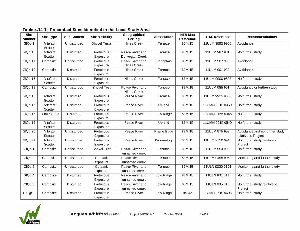
Table 4.14-1: Precontact Sites Identified in the Local Study Area.........................................4-458 Table 4.14-2: Historic Sites Identified in the Local Study Area ..............................................4-459 Table 4.14-3: Project Environmental Effects Interaction Matrix: Heritage Resources,
Traditional Knowledge and Land Use..............................................................4-462 Table 4.14-4: Environmental Effects Assessment Matrix : Heritage Resources....................4-465 Table 4.14-5: Predicted Effects of the Project on Heritage Resource Sites Identified...........4-468 Table 4.14-6: Cumulative Effects from the Project and Other Developments on
Heritage Resource Sites by Site Type.............................................................4-470 Table 4.14-7: Residual Environmental Effects Summary Matrix: Heritage Resources..........4-471
List of Figures
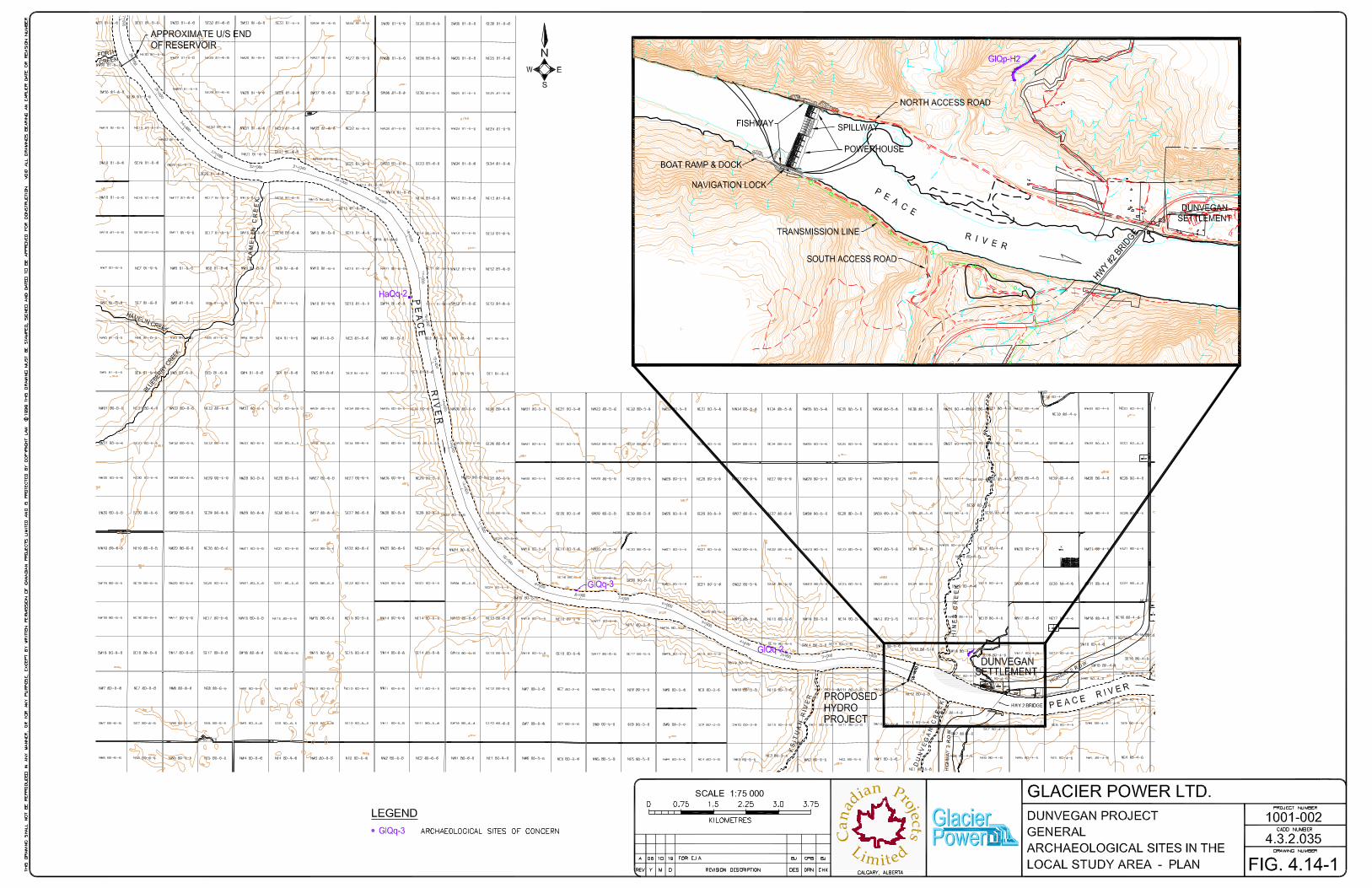
Figure 4.14-1: Archaeological Sites in the Local Study Area.................................................4-457
Jacques Whitford © 2006 Project ABC50541 October 2006 4-4.14-i

4.14 Heritage Resources And Traditional Knowledge And Land Use Heritage resources and traditional knowledge and land use were selected as a VEC because of several factors: • the nature of the Project
• the known and predicted archaeological, historical and palaeontological potential of the RSA
• public concern for heritage conservation
• a requirement for assessment of effects on heritage resources contained within Terms of Reference set by the Archaeological Survey of Alberta pursuant to the Alberta Historical Resources Act
• the need to meet CEAA requirements Historical resources impact assessments (HRIAs) were carried out for Project by FMA Heritage Resource Consultants (FMA 2000, 2004). FMA (2000) assessed effects of the Project while FMA (2005) focused on the south access road and transmission line. Traditional knowledge and land use was incorporated into the heritage resources VEC because of the close connection between heritage resources and the history of the Aboriginal people in the area, specifically, the Duncan’s First Nations. FMA carried out a Traditional Knowledge and Land Use Effects Assessment of the Project (2006). Consultation with Aboriginal communities is discussed in Section 6. Section 7.3 and 8 of the joint Alberta Energy & Utilities Board (EUB) and Natural Resources Conservation Board (NRCB) panel review and decision (March 2003) addresses effects on downstream communities and Glacier Power’s public and Aboriginal consultation program. The panel findings state that effects on downstream communities such as Paddle Prairie (350 km), Fort Smith and Fort Resolution (1000 km plus) would be insignificant given the design and scale of the Project. The Project and its environmental effects on downstream communities have not changed since the previous application in 2000. 4.14.1 Boundaries 4.14.1.1 Spatial Boundaries The archaeological and heritage resources field assessment concentrated on areas to be directly affected by project-related water levels, access roads, transmission lines and other associated facilities. Thus, the local study area (LSA) is the area of the project disturbance. A RSA, defined to place the findings of the assessment in a broader cultural and environmental context, includes the Peace River valley from the confluence with Smoky River to Bennett Dam in central British Columbia. The traditional knowledge and land use assessment included the traditional territory of the Duncan’s First Nations, focusing on the LSA. The Duncan’s First Nations main reserve is near the town of Brownvale, approximately 40 km east of the project headworks.
Jacques Whitford © 2006 Project ABC50541 October 2006 4-455
4.14.1.2 Temporal Boundaries Heritage resources within the LSA may be disturbed at several stages throughout the life of the Project. During the planning stage, sites may be affected by geotechnical investigations. At the construction phase, sites could be affected by ground clearing and excavation, vehicle traffic and other activities associated with ground preparation and installation of the project facilities and related infrastructure. During operation of the facility, sites could be affected by inundation and concealment, by the effects of waves and ice, by undercutting of formations containing heritage resources, and by any modification of infrastructure facilities. At the end of the life of the Project, sites could be affected during decommissioning activities. During the life of the Project, malfunctions and accidents and associated remediation activities may affect heritage resources. Therefore, the temporal boundaries extend from 2008 to 2111. 4.14.1.3 Administrative Boundaries Heritage resources in Alberta are protected under the Historical Resources Act administered by the Archaeological Survey of Alberta, Alberta Community Development. Sites considered to be valued as archaeological, historic or palaeontological resources may not be disturbed except under strictly controlled conditions imposed by terms of an impact assessment or impact mitigation permit. 4.14.1.4 Technical Boundaries Limitations imposed on this assessment include the inability to accurately and completely predict the presence of all heritage resources within the LSA. However, previous experience in the area and with similar projects allowed FMA to develop a predictive model which has identified most sites or areas with high or moderate potential for heritage resources. 4.14.2 Description of Existing Conditions 4.14.2.1 Local Database Precontact, historic and paleontological sites in the LSA are discussed in the next section. The archaeological sites of concern, based on their nearness to the Project and potential for disturbance, are shown in Figure 4.14-1. 4.14.2.1.1 Precontact Sites Twenty-two precontact sites are on record in the LSA (Table 4.14-1). Two are isolated finds, nine are artefact scatters, and 11 are campsites. Six sites are either well above or well removed from proposed development (GlQp 20, GlQp 21, GlQq 5, HaQr 1, HaQr 2, HaQr 3). Nine of the sites (GlQp 10, GlQp 13, GlQp 16, GlQp 17, GlQp 18, GlQp 19, GlQq 1, GlQq 4, HaQp 1) are of limited scientific and public value. No precontact sites were found along the south access road or transmission line. 4.14.2.1.2 Historic Sites Three historic period sites were recorded in the LSA (Table 4.14-2). One contains homestead remains (GlQq H1), one represents a recent geotechnical test site (GlQp H1), and one represents a trail (GlQp H2). No historic sites were found along the south access road or transmission line.
Jacques Whitford © 2006 Project ABC50541 October 2006 4-456

Jacques Whitford © 2006 Project ABC50541 October 2006 4-458
Table 4.14-1: Precontact Sites Identified in the Local Study Area Site
Number Site Type Site Context Site Visibility Geographical Setting Association NTS Map
Reference UTM. Reference Recommendations
GlQp 1 Artefact Scatter
Undisturbed Shovel Tests Hines Creek Terrace 83M/15 11ULM 9895 9900 Avoidance
GlQp 10 Artefact Scatter
Disturbed FortuitousExposure
Peace River and Dunvegan Creek
Terrace 83M/15 11ULM 987 981 No further study
GlQp 11 Campsite Undisturbed Fortuitous Exposure
Peace River and Hines Creek
Floodplain 83M/15 11ULM 987 990 Avoidance
GlQp 12 Campsite Disturbed Fortuitous Exposure
Hines Creek Terrace 83M/15 11ULM 991 989 Avoidance
GlQp 13 Artefact Scatter
Disturbed FortuitousExposure
Hines Creek Terrace 83M/15 11ULM 9900 9895 No further study
GlQp 15 Campsite Undisturbed Shovel Test Peace River and Hines Creek
Terrace 83M/15 11ULM 985 991 Avoidance or further study
GlQp 16 Artefact Scatter
Disturbed FortuitousExposure
Peace River Terrace 83M/15 11ULM 9925 9660 No further study
GlQp 17 Artefact Scatter
Disturbed FortuitousExposure
Peace River Upland 83M/15 11UMN 0015 0050 No further study
GlQp 18 Isolated Find Disturbed Fortuitous Exposure
Peace River Low Ridge 83M/15 11UMN 0155 0045 No further study
GlQp 19 Artefact Scatter
Disturbed FortuitousExposure
Peace River Upland 83M/15 11UMN 0215 0540 No further study
GlQp 20 Artefact Scatter
Undisturbed FortuitousExposure
Peace River Prairie Edge 83M/15 11ULM 975 998 Avoidance and no further study relative to Project
GlQp 21 Artefact Scatter
Undisturbed FortuitousExposure
Peace River Promontory 83M/15 11ULM 9750 9945 No further study relative to Project
GlQq 1 Campsite Undisturbed Shovel Test Peace River and unnamed creek
Terrace 83M/15 11ULM 954 995 No further study
GlQq 2 Campsite Undisturbed Cutbank exposure
Peace River and unnamed creek
Terrace 83M/15 11ULM 9495 9950 Monitoring and further study
GlQq 3 Campsite Undisturbed Cutbank exposure
Peace River and unnamed creek
Terrace 83M/15 11ULN 9020 0105 Monitoring and further study
GlQq 4 Campsite Disturbed Fortuitous Exposure
Peace River and unnamed creek
Low Ridge 83M/15 11ULN 901 011 No further study
GlQq 5 Campsite Disturbed Fortuitous Exposure
Peace River and unnamed creek
Low Ridge 83M/15 11ULN 895 012 No further study relative to Project
HaQp 1 Campsite Disturbed Fortuitous Exposure
Peace River Low Ridge 84D/2 11UMN 0410 0695 No further study

Jacques Whitford © 2006 Project ABC50541 October 2006 4-459
Precontact Sites Identified in the Local Study Area Site Type Site Context Site Visibility Geographical
Setting Association NTS Map Reference UTM. Reference Recommendations
HaQq 2 Campsite Undisturbed Cutbank Exposure
Peace River Floodplain 84D/2 11ULN 864 079 Monitoring and further study
HaQr 1 Campsite Undisturbed Shovel Tests Peace River and Hamelin Creek
Terrace 84D/2 11ULN 8295 1050 Avoidance and no further study relative to Project
HaQr 2 Artefact Scatter
Undisturbed Shovel Tests Peace River and Hamelin Creek
Terrace 84D/2 11ULN 832 105 Avoidance and no further study relative to Project
HaQr 3 Isolated Find Disturbed Fortuitous Exposure
Peace River Terrace 84D/2 11ULN 8375 1050 No further study relative to Project
Notes: NTS National Topographic System UTM Universal Transverse Mercator
Table 4.14-2: Historic Sites Identified in the Local Study Area
Site Number Site Type Site
Context Site Visibility Geographical Setting Association NTS Map
Reference UTM Reference Recommendations
GlQp H1 Geotechnical Test
Undisturbed Surficial Features Peace River Bank 83M/15 11ULM 972 996 No further study
GlQp H2 Trail Undisturbed Surficial Feature Peace River Terrace 83M/15 11ULM 990-995
990-996
No further study; placement of poles at edge of trail
GlQq H1 Homestead Undisturbed Surficial Features Peace River Floodplain 83M/15 11ULN 897 012 No further study relative to
Project Notes: NTS National Topographic System UTM Universal Transverse Mercator
Table 4.14-1: Site
Number
4.14.2.1.2 Palaeontological Sites Locally, float of mussel coquinas were common, indicating their nearby occurrence in situ. However, because of poor exposures, no primary occurrences were found. A single horizon with isolated Ostrea specimens was found at the base of the sandstone at approximately km 3 of the headpond. Specimens were collected for the Royal Tyrell Museum of Palaeontology (Tyrell Museum) in Alberta. Unionid shell fragments were found on talus slopes. Trace fossils, although not common, are present throughout the area. Specimens were collected for the Tyrell Museum. When the Dunvegan Formation was initially described by G. M. Dawson in 1881, no type section was designated and subsequent researchers in the area have still not designated a type section. Therefore, the area remains an important reference area for the formation within the context of the stratigraphic code. Type sections and sites are of national and international palaeontological value because they are of critical importance as standards of comparison for identification of lithological structure and lateral facies change, and fossil contents. The LSA includes an area flanked by the middle and upper portions of the formation. 4.14.2.2 Regional Database The regional database consists of all sites recorded in the 64 Borden Units associated with the valley of the Peace River between Smoky River and Bennett Dam. Of these 64 units, 13 blocks (GlQj, GlQk, GlQm, GlQn, GlQr, GlQs, HaQl, HaQs, HaQv, HbQj, HbQt, HcQs, HcQt) have no recorded associated sites. Within the Alberta study region, 139 (84.2 percent) of the components are associated with the precontact era and 13 components (7.9 percent) date to the historic period. One palaeontological site is on record in the RSA in each of the provinces. In British Columbia, 639 components (93.3 percent) are precontact and 54 (7.9 percent) are of historic age. There are no data for 13 sites (7.7 percent) in Alberta and 7 sites (1 percent) in British Columbia. 4.14.2.2.1 Precontact Sites Because some of the site types represent relatively uncommon occurrences, for discussion purposes, similar site types have been grouped. Lithic (artefact) scatters are the most common site in the RSA. However, because defined site types differ between Alberta and British Columbia, there is a bias towards this site type as isolated finds and campsites are not represented in the British Columbia inventory. Further, site types present in British Columbia are not represented in the Alberta inventory, i.e., hearths, cache pits, depressions, mounds, stone feature (cairns, tent rings, stone alignments), petroforms and petroglyphs. Together, these site types represent less than three percent of the regional inventory. Over one-half of the precontact sites in the RSA in Alberta were recorded as a result of the Dunvegan Feasibility Study (Acres Consulting Ltd. et al. 1976). The remainder were recorded during HRIAs of developments and as part of problem-oriented research projects. Artefact scatters (51.1 percent) are the most commonly occurring site type, followed by campsites (34.5 percent). Isolated finds (12.2 percent) are also relatively common, whereas sites classified as workshops (1.4 percent) and burials (0.7 percent) are relatively rare. There are no available data as to site types for 9.4 percent (N = 3) of the recorded precontact sites in Alberta. Of the sites in the RSA in British Columbia, 310 were recorded as part of a five-year study associated with BC Hydro Site C downstream from the confluence of Peace and Moberly rivers (Spurling 1980).
Jacques Whitford © 2006 Project ABC50541 October 2006 4-460
The largest proportion (93.6 percent) of the total identified site types are classified as lithic (artefact) scatters. Only 1.3 percent are campsites and 1.4 percent are isolated finds. The remaining 3.8 percent are represented by petroform and petroglyphs, pits and depressions, mounds and burials. 4.14.2.2.2 Historic Sites For discussion purposes, some of the historic site type categories have been grouped. Most of these sites were identified as a result of HRIAs of proposed developments. The largest number of historic sites (N = 25; 37.3 percent) are cabins and structures. Next most frequent are homesteads (N = 15; 22.4 percent), followed by trading posts (N = 11; 16.4 percent). Historic campsites and artefact scatters are also well represented (N = 8; 11.9 percent). Missions (N = 2; 3 percent), root cellars (N = 3; 4.5 percent), burials (N = 2; 3 percent) and trails (N = 1; 1.5 percent) are not common sites types in the historic inventory. The only trail recorded is associated with the Project. The total number of historic sites identified in the LSA represents five percent of the total number of historic sites recorded in the RSA. 4.14.2.2.3 Palaeontological Sites Previously recorded palaeontological sites in the RSA consist of collections originating just downstream from the LSA, on the north side of the Peace River on the highway, and collections from British Columbia. The potential type section for the Dunvegan Formation is in the LSA. Finds of unionids were made within the LSA. 4.14.3.4 Traditional Land Uses The Duncan’s First Nations identified a medicinal or sacred plant area on the north side of the Peace River at the confluence of Hines and Dunvegan Creeks. 4.14.3 Potential Interactions, Issues and Concerns The Project can interact with heritage resources during all project phases. The following heritage resource issues were identified relative to the Project, based on historical resource legislation, perceived effects on a non-renewable resource from a scientific perspective, and public concerns regarding potential effects on cultural properties: • disturbance of identified heritage resource sites • disturbance to the Dunvegan Historic Park Potential interactions are summarized in Table 4.14-3 and discussed in the following sections.
Jacques Whitford © 2006 Project ABC50541 October 2006 4-461
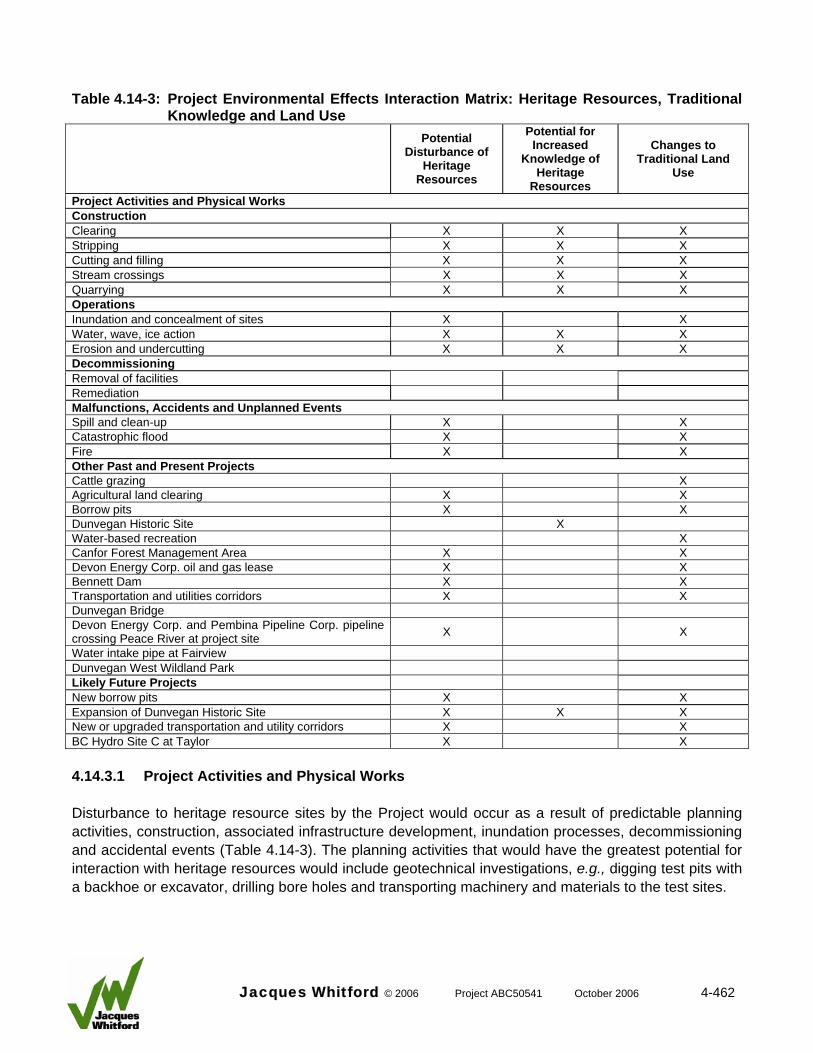
Table 4.14-3: Project Environmental Effects Interaction Matrix: Heritage Resources, Traditional
Knowledge and Land Use
Potential Disturbance of
Heritage Resources
Potential for Increased
Knowledge of Heritage
Resources
Changes to Traditional Land
Use
Project Activities and Physical Works Construction Clearing X X X Stripping X X X Cutting and filling X X X Stream crossings X X X Quarrying X X X Operations Inundation and concealment of sites X X Water, wave, ice action X X X Erosion and undercutting X X X Decommissioning Removal of facilities Remediation Malfunctions, Accidents and Unplanned Events Spill and clean-up X X Catastrophic flood X X Fire X X Other Past and Present Projects Cattle grazing X Agricultural land clearing X X Borrow pits X X Dunvegan Historic Site X Water-based recreation X Canfor Forest Management Area X X Devon Energy Corp. oil and gas lease X X Bennett Dam X X Transportation and utilities corridors X X Dunvegan Bridge Devon Energy Corp. and Pembina Pipeline Corp. pipeline crossing Peace River at project site X X
Water intake pipe at Fairview Dunvegan West Wildland Park Likely Future Projects New borrow pits X X Expansion of Dunvegan Historic Site X X X New or upgraded transportation and utility corridors X X BC Hydro Site C at Taylor X X 4.14.3.1 Project Activities and Physical Works Disturbance to heritage resource sites by the Project would occur as a result of predictable planning activities, construction, associated infrastructure development, inundation processes, decommissioning and accidental events (Table 4.14-3). The planning activities that would have the greatest potential for interaction with heritage resources would include geotechnical investigations, e.g., digging test pits with a backhoe or excavator, drilling bore holes and transporting machinery and materials to the test sites.
Jacques Whitford © 2006 Project ABC50541 October 2006 4-462
Construction activities that may affect heritage resource sites include forest and vegetation clearing, soil removal, grading and cut or fill operations, stream crossings and quarrying, which would result in an alteration or removal of existing archaeological, historical and palaeontological site components and features. Associated infrastructure development that may affect heritage resources would consist of access (including roads and transmission line rights-of-way), a boat ramp, the powerhouse and weir and associated disturbances. During the operations phase, inundation processes would not only conceal landforms and any associated sites but would also affect these features as a result of water, wave or ice action. Sites at higher elevations could be affected through undercutting or erosional processes associated with higher water levels. During the decommissioning phase, it is highly unlikely that any sites in or adjacent to development areas will be affected during the removal of facility and infrastructure materials, or by site remediation processes. Site locations will be well known, and avoidance or protection procedures will be in effect. Malfunctions, accidents and unplanned events also have some potential for disturbance of heritage resources, e.g., a spill of fuel or chemicals near a site, and the resultant cleanup activities; catastrophic flooding; or a fire. During some of these activities, there will be some potential for gathering additional information on heritage resources, e.g., through mitigative recording of any unanticipated sites found during construction or site components revealed during monitoring. Interaction with identified sites GlQp H2, GlQp 17, GlQp 18, GlQp 19 and HaQp 1 has been avoided through transmission line route selection. The north access road, to the crossing of Hines Creek corresponds with the gravel bar or floodplain and avoids disturbing precontact site GIQp 1. A barge laydown area has been proposed for the gravel bar or floodplain to the west of the mouth of Hines Creek. The gravel bar or floodplain has been disturbed previously by gravel operations and currently is scoured by winter ice floes. The route continues west of Hines Creek near GlQp 15 where it climbs to the existing terrace. Glacier Power is committed to avoiding GlQp 15 by a minor realignment. The transmission line route parallels the revised access road with the exception of the Dunvegan Creek crossing which will be spanned rather than constructed parallel to the creek upstream. The road alignment, following an existing trail, extends westward from Highway 2 almost to the crossing of Dunvegan Creek. Site GlQp 10 will be affected by the routing of the access road. However, G1Qp 10 is a disturbed artefact scatter with little heritage resource value and no further study of it is required. As it approaches the east bank of Dunvegan Creek, the alignment approximately parallels the creek to within 300 m of the creek mouth where the crossing will occur. On the west side of Dunvegan Creek, the alignment follows the terrace edge to continue paralleling Peace River to the powerhouse and weir facility. Much of the route follows an erosional face parallel to Peace River and is unlikely to contain such sites. On the east side of Highway 2, the road alignment follows an existing trail to ATCO’s 144-kV transmission line. An approximately 1-km segment of the route has been identified as the tie-in with the existing 144-kV transmission line. This segment, which was not examined in the field, would cross primarily cultivated lands. A previously recorded site, GlQp 16, is south of this segment, therefore, an HRIA will be done before construction. The Project may interfere with traditional land uses along Hines Creek.
Jacques Whitford © 2006 Project ABC50541 October 2006 4-463
4.14.3.2 Interactions with Past, Present and Likely Future Projects Heritage resource inventories are largely compiled as a result of HRIAs of proposed projects. Thus, past, present and likely future projects interact with the heritage resources VEC through the generation of new heritage resource information. Other projects can also cause the disturbance or loss of heritage resource information due to project construction (which can damage or destroy sites) and through the provision of increased access (allowing clandestine collecting, disturbance and vandalism). Many of the other activities and projects in the region have interfered with traditional land uses in the area. 4.14.4 Residual Environmental Effects Evaluation Criteria A significant adverse effect on heritage resources would involve the destruction or disturbance of all or part of an archaeological, historic or palaeontological site considered to be of local, regional, provincial, national or international value. This effect, if not controlled through mitigative investigation and documentation, as required by the provincial regulator, would result in the permanent loss of part of the non-renewable heritage resource base. A significant adverse effect on traditional land use is one that prevents First Nations from carrying out tradition pursuits, either through the destruction of a resource used or the prevention of access to a resource. A significant adverse effect on traditional land use is one that prevents First Nations from carrying out traditional pursuits, either through the destruction of a resource used or the prevention of access to a resource. A positive effect will increase the local, regional, provincial, national or international knowledge of heritage resources through inventory, documentation, protection, interpretation or other means. 4.14.5 Effects Analysis, Mitigation and Residual Effects Prediction Archaeological, historical and palaeontological sites are non-renewable and are susceptible to alteration, damage and destruction by any type of development. The value of these resources cannot be measured in terms of individual artefacts or biological specimens. Rather, the value of heritage resources lies in the integrated information derived from the interrelationship of the individual artefacts and fossil specimens, associated features, spatial relationships (distribution) and contextual situation. Interpretation of heritage resource materials, and the ability to interpret the significance of particular sites in a landscape, is based on an understanding of the nature of the relationship between archaeological or palaeontological materials and the sediments and strata within which they are contained. Removal or mixing of these sediments results in the permanent loss of information basic to the understanding of these resources. As a result, heritage resources are susceptible to destruction and depletion through disturbance. Table 4.14-4 presents the environmental effects analysis matrix for the heritage resources VEC and includes the analysis of the effects and the proposed mitigation. The effects analysis is discussed in the following sections.
Jacques Whitford © 2006 Project ABC50541 October 2006 4-464

Table 4.14-4: Environmental Effects Assessment Matrix : Heritage Resources
Evaluation Criteria for Assessing Environmental
Effects
Project Activity Potential Positive (P)
or Adverse (A) Environmental Effect
Mitigation
Mag
nitu
de
Geo
grap
hic
Exte
nt
Dur
atio
n or
Fre
quen
cy
Rev
ersi
bilit
y
Ecol
ogic
al, S
ocio
cultu
ral
and
Econ
omic
Con
text
Project Planning • Geotechnical test
pits • Geotechnical bore
holes • Geotechnical
vehicle travel
• Disturbance of heritage resources (A)
• Enhanced understanding of heritage resources if sites found and recorded (P)
− Avoidance of known heritage resources if possible
− Site documentation and other mitigation as approved by regulator
− Heritage resources contingency plan
1 2 2/2 I 2
Construction • Forest, vegetation
clearing • Soil removal • Cut and fill • Stream crossing • Quarrying • Access roads,
transmission line and other facilities
• Disturbance of heritage resources (A)
• Enhanced understanding of heritage resources if sites found and recorded (P)
− Avoidance of heritage resources identified for protection
− Site documentation and other mitigation as approved by regulator
− Heritage resources contingency plan
1 2 2/2 I 2
Operations Inundation • Concealment of and loss
of access to sites (A) • Enhanced understanding
of heritage resources if sites found and recorded (P)
− Avoid inundation of known heritage resources if possible
− Site documentation and other mitigation as approved by regulator
− Heritage resources contingency plan
1 3 5/6 I 2
Water, wave and ice action
• Disturbance of heritage resources (A)
• Enhanced understanding of heritage resources if sites found and recorded (P)
− Site stabilization and protection
− Effects monitoring − Site documentation
and mitigation as approved by regulator
− Heritage resources contingency plan
1 3 5/6 I 2
Erosion and undercutting of landforms
• Disturbance of heritage resources (A)
• Enhanced understanding of heritage resources if sites found and recorded (P)
− Site stabilization and protection
− Effects monitoring − Site documentation
and mitigation as approved by regulator
− Heritage resources contingency plan
3 1 5/6 I 2
Jacques Whitford © 2006 Project ABC50541 October 2006 4-465

Table 4.14-4: Environmental Effects Assessment Matrix : Heritage Resources Evaluation Criteria for
Assessing Environmental Effects
Project Activity Potential Positive (P)
or Adverse (A) Environmental Effect
Mitigation
Mag
nitu
de
Geo
grap
hic
Exte
nt
Dur
atio
n or
Fre
quen
cy
Rev
ersi
bilit
y
Ecol
ogic
al, S
ocio
cultu
ral
and
Econ
omic
Con
text
Decommissioning Removal of project facilities; remediation
• N/A
Malfunctions, Accidents and Unplanned Events Fuel or chemical spill and cleanup
• Contamination of site (A) • Disturbance of heritage
resources during cleanup (A)
• Enhanced understanding of heritage resources if sites found and recorded (P)
− Avoidance of known heritage resources if possible
− Site documentation and other mitigation as approved by regulator
− Heritage resources contingency plan
1 1 1/1 I 2
Catastrophic flood • Site erosion (A) • Historic site disturbance
(A)
− Project design 1 2 1/1 I 2
Fire • Contamination of site by modern charcoal or fire-fighting materials and methods (A)
• Destruction of historic site (A)
− Project design 1 3 1/1 I 2
KEY: Magnitude: 1 = Low: e.g., loss of a minor proportion of
data at site, local or regional level; after low-impact, interpretive capacity of the remains is virtually intact, limited only by loss of minor items and features
2 = Medium: e.g., a proportion of the data at
the site, local or regional level is lost but a significant proportion remains unimpaired; after medium impact, the interpretive capacity of the remains is hindered by loss of basic data about cultural descriptions and lifestyles
3 = High: e.g., a significant proportion of data
at the site, local or regional level is lost; interpretive capacity of the remains following impact is minimal
Geographic Extent: 1 = less than 1 km² 2 = 1–10 km² 3 = 11–100 km² 4 = 101–1000 km² 5 = 1001–10,000 km² 6 = more than 10,000 km² Duration: 1 = less than 1 month 2 = 1–12 months 3 = 13–36 months 4 = 37–72 months 5 = more than 72 months
Frequency: 1 = less than 11 events per year 2 = 11–50 events per year 3 = 51–100 events per year 4 = 101–200 events per year 5 = more than 200 events per year 6 = continuous Reversibility: R = reversible I = irreversible
Ecological, Socio-cultural and Economic Context: 1 = relatively pristine area
or area not adversely affected by human activity
2 = evidence of adverse
effects N/A = not applicable
Jacques Whitford © 2006 Project ABC50541 October 2006 4-466
Jacques Whitford © 2006 Project ABC50541 October 2006 4-467
4.14.5.1 Effects of the Project on Heritage Resources During the HRIA, 25 heritage resource sites (3 historic and 22 precontact) were identified. Of these, 11 of the precontact and all 3 of the historic sites are undisturbed. The remainder have been disturbed by either agricultural practices (N = 7) or previous development (N = 4). Twenty-one of the sites are not in direct conflict with the development (Table 4.14-5). One site (GlQq 3) could be subject to erosion and flooding and may require some mitigation (Figure 4.14-1). This site is currently undisturbed and is of sufficient heritage resource value to warrant either avoidance or further study. Sites GlQp 11 and GlQp 12 (with high and moderate heritage resource values respectively) are adjacent to proposed access roads. Avoidance of the productive areas of these sites has been recommended; no further mitigation is considered necessary. Because of the unknown effects of erosion, an additional two currently undisturbed sites (GlQq 2, HaQq 2) with moderate to high heritage resource values have been recommended for monitoring (Figure 4.14-1). These two sites represent eight percent of the total number of recorded sites within the LSA. Site HaQr 2, which has high heritage resource values, will not be affected by the Project. Historical resource site GlQp 10 is in direct conflict with the Project but has little heritage resource value; no further study is recommended at this site. In the unlikely event of unanticipated discovery of heritage resources during construction-related activities, work will cease in the immediate vicinity of the discovery pending notification of the provincial regulator and approval for resumption of work. Site inventory studies associated with the Project have resulted in an increase in the existing database for the LSA through the collection of information such as site location, type, content, context and association. The effect of these activities on the extent of current scientific knowledge on the culture history of the area has been positive. The Cultural Facilities and Historical Resources Division (CFHRD) of Alberta Community Development (ACD) reviewed the final reports by FMA with results of the HRIAs for the Project. Their response letters are attached as Appendix E., CFHRD summarized Glacier Power’s Historical Resource Act requirements in their letter of June16, 2005. These requirements consist of the following: • An HRIA is to be conducted on the north access road before construction.
• An initial excavation is to be carried out at site GlQq-3.
• Site GlQq-2 is to be monitored by an archaeologist following infilling of the headpond to determine if the site is being undercut.
• Site HaQq-2 is to be monitored by an archaeologist following infilling of the headpond to determine if the site is being undercut.
• Construction of the south access road and transmission line is to be monitored by a palaeontologist for the exposure of any paleontological resources.
• A detailed stratigraphic and sedimentological study of the Dunvegan Formation Type section is to be done before project development.
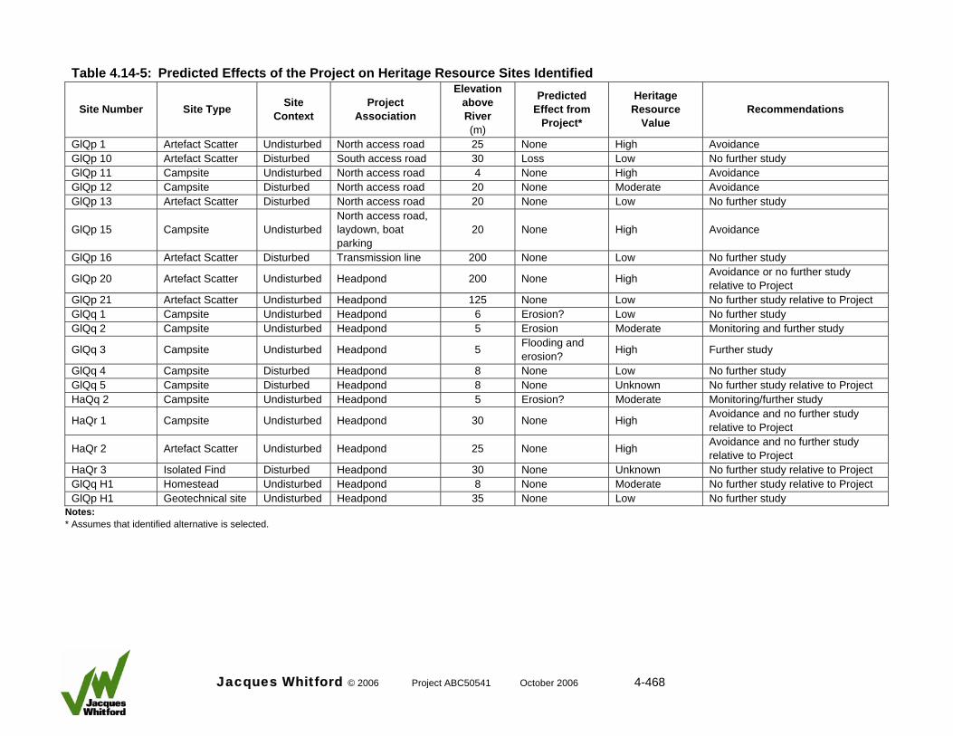
Jacques Whitford © 2006 Project ABC50541 October 2006 4-468
Table 4.14-5: Predicted Effects of the Project on Heritage Resource Sites Identified
Site Number Site Type Site Context
Project Association
Elevation above River (m)
Predicted Effect from
Project*
Heritage Resource
Value Recommendations
GlQp 1 Artefact Scatter Undisturbed North access road 25 None High Avoidance GlQp 10 Artefact Scatter Disturbed South access road 30 Loss Low No further study GlQp 11 Campsite Undisturbed North access road 4 None High Avoidance GlQp 12 Campsite Disturbed North access road 20 None Moderate Avoidance GlQp 13 Artefact Scatter Disturbed North access road 20 None Low No further study
GlQp 15 Campsite Undisturbed North access road, laydown, boat parking
20 None High Avoidance
GlQp 16 Artefact Scatter Disturbed Transmission line 200 None Low No further study
GlQp 20 Artefact Scatter Undisturbed Headpond 200 None High Avoidance or no further study relative to Project
GlQp 21 Artefact Scatter Undisturbed Headpond 125 None Low No further study relative to Project GlQq 1 Campsite Undisturbed Headpond 6 Erosion? Low No further study GlQq 2 Campsite Undisturbed Headpond 5 Erosion Moderate Monitoring and further study
GlQq 3 Campsite Undisturbed Headpond 5 Flooding and erosion? High Further study
GlQq 4 Campsite Disturbed Headpond 8 None Low No further study GlQq 5 Campsite Disturbed Headpond 8 None Unknown No further study relative to Project HaQq 2 Campsite Undisturbed Headpond 5 Erosion? Moderate Monitoring/further study
HaQr 1 Campsite Undisturbed Headpond 30 None High Avoidance and no further study relative to Project
HaQr 2 Artefact Scatter Undisturbed Headpond 25 None High Avoidance and no further study relative to Project
HaQr 3 Isolated Find Disturbed Headpond 30 None Unknown No further study relative to Project GlQq H1 Homestead Undisturbed Headpond 8 None Moderate No further study relative to Project GlQp H1 Geotechnical site Undisturbed Headpond 35 None Low No further study
Notes: * Assumes that identified alternative is selected.
Glacier Power commits to meet all these requirements. After mitigation, the effects of the Project on the heritage resources within the LSA will be not significant. Although site contexts will be destroyed and some of the site contents will be lost, the recommended mitigation measures are considered acceptable to Alberta Community Development. The effect will also be positive because the sites have been recorded and added to the provincial database, and scientific data will be retrieved as a result of mitigation studies. The duration of the effect will be long term. Within the context of the nature of heritage resources, the effect will be irreversible. 4.14.5.2 Effects of the Project on Traditional Land Use The headpond is upstream from Hines Creek. The north access road will cross the lower portion of Hines Creek. However, the access road is not expected to interact with the traditional land use area on Hines Creek as identified by the Duncan’s First Nations. The Project is not expected to interact with any other traditional land uses in the area. Glacier Power will continue to consult with the Duncan’s First Nations regarding activities that may affect their traditional land use. 4.14.5.3 Cumulative Environmental Effects Cumulative effects include those effects likely to result from the Project and those that result from other past, present and planned or approved future projects or activities. Assessment of the cumulative effect of development on heritage resources can be measured only in the broadest of terms. The inventory of heritage resource sites in the general area of the Project has been compiled primarily through HRIAs. Therefore, the annual growth of the inventory represents an index of the cumulative effects of development on the heritage resources in this portion of Alberta. The cumulative effect of nondevelopment-related effects on heritage resources is much more difficult to measure. These result from increased human presence, as well as clandestine collection, disturbance and vandalism of known heritage resources. Erosion, slumping, precipitation, frost cracking, effects of acidic soils on organic materials and other natural events and actions also take a continuous toll on heritage resources. Table 4.14-6 summarizes the available information regarding cumulative effects by development on heritage resource site types in the RSA as defined by the relevant Borden Blocks. There is a lack of information (regarding site context and current disturbance) in the site data available from British Columbia. Consequently, the proportion of sites which have been affected by other development, including agricultural practices, is probably under-represented in the table.
Jacques Whitford © 2006 Project ABC50541 October 2006 4-469
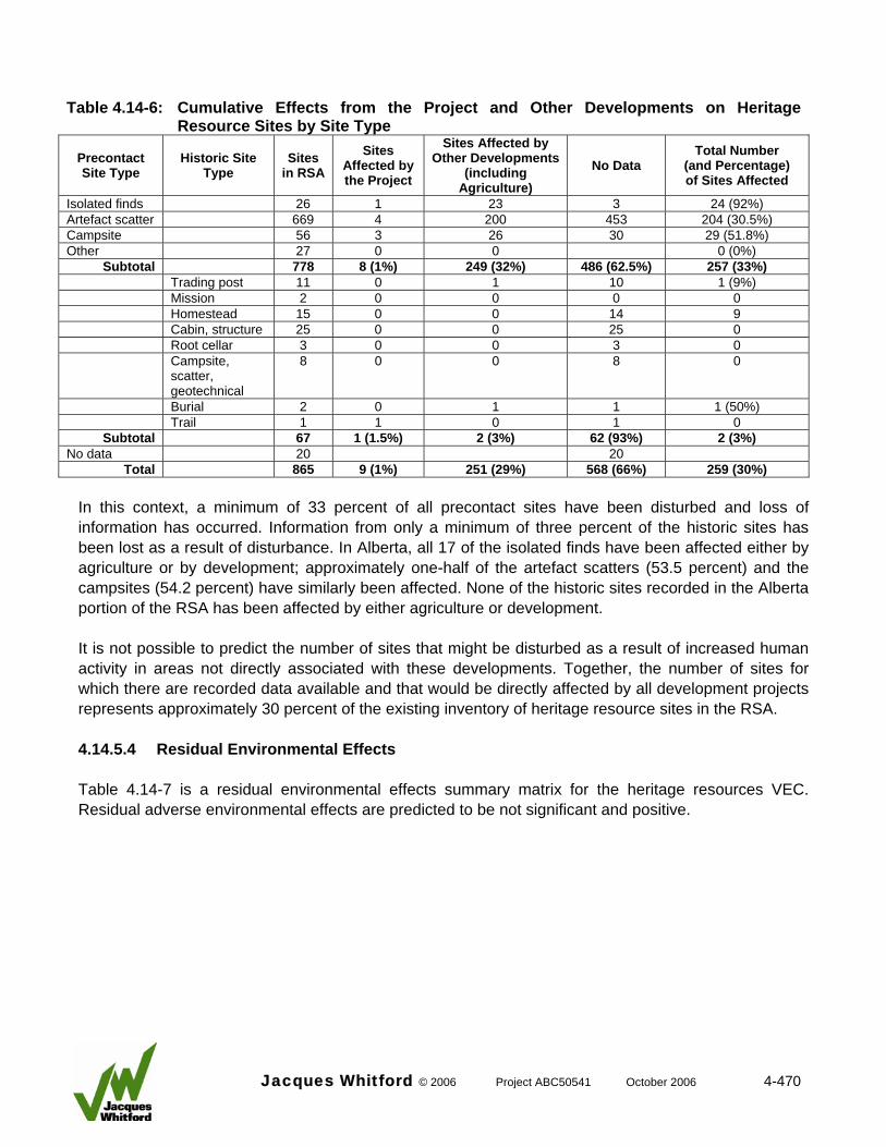
Table 4.14-6: Cumulative Effects from the Project and Other Developments on Heritage
Resource Sites by Site Type
Precontact Site Type
Historic Site Type
Sites in RSA
Sites Affected by the Project
Sites Affected by Other Developments
(including Agriculture)
No Data Total Number
(and Percentage) of Sites Affected
Isolated finds 26 1 23 3 24 (92%) Artefact scatter 669 4 200 453 204 (30.5%) Campsite 56 3 26 30 29 (51.8%) Other 27 0 0 0 (0%)
Subtotal 778 8 (1%) 249 (32%) 486 (62.5%) 257 (33%) Trading post 11 0 1 10 1 (9%) Mission 2 0 0 0 0 Homestead 15 0 0 14 9 Cabin, structure 25 0 0 25 0 Root cellar 3 0 0 3 0 Campsite,
scatter, geotechnical
8 0 0 8 0
Burial 2 0 1 1 1 (50%) Trail 1 1 0 1 0
Subtotal 67 1 (1.5%) 2 (3%) 62 (93%) 2 (3%) No data 20 20
Total 865 9 (1%) 251 (29%) 568 (66%) 259 (30%) In this context, a minimum of 33 percent of all precontact sites have been disturbed and loss of information has occurred. Information from only a minimum of three percent of the historic sites has been lost as a result of disturbance. In Alberta, all 17 of the isolated finds have been affected either by agriculture or by development; approximately one-half of the artefact scatters (53.5 percent) and the campsites (54.2 percent) have similarly been affected. None of the historic sites recorded in the Alberta portion of the RSA has been affected by either agriculture or development. It is not possible to predict the number of sites that might be disturbed as a result of increased human activity in areas not directly associated with these developments. Together, the number of sites for which there are recorded data available and that would be directly affected by all development projects represents approximately 30 percent of the existing inventory of heritage resource sites in the RSA. 4.14.5.4 Residual Environmental Effects Table 4.14-7 is a residual environmental effects summary matrix for the heritage resources VEC. Residual adverse environmental effects are predicted to be not significant and positive.
Jacques Whitford © 2006 Project ABC50541 October 2006 4-470
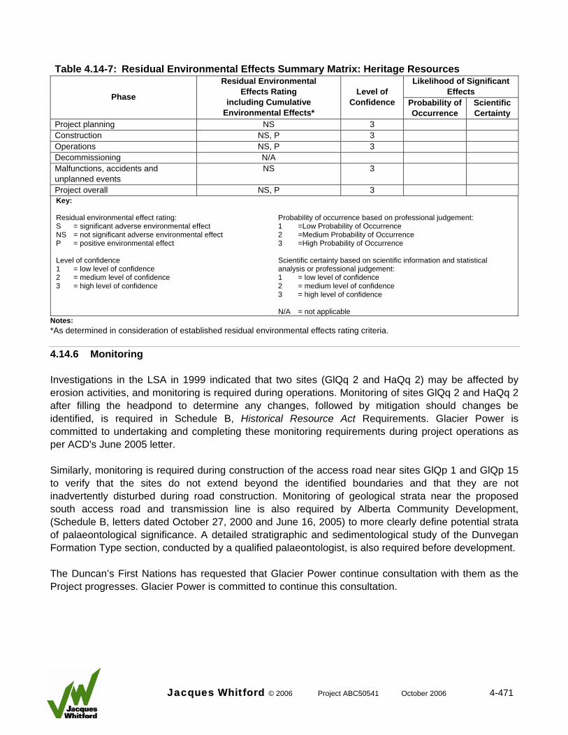
Table 4.14-7: Residual Environmental Effects Summary Matrix: Heritage Resources
Likelihood of Significant Effects Phase
Residual Environmental Effects Rating
including Cumulative Environmental Effects*
Level of Confidence Probability of
Occurrence Scientific Certainty
Project planning NS 3 Construction NS, P 3 Operations NS, P 3 Decommissioning N/A Malfunctions, accidents and unplanned events
NS 3
Project overall NS, P 3 Key: Residual environmental effect rating: S = significant adverse environmental effect NS = not significant adverse environmental effect P = positive environmental effect Level of confidence 1 = low level of confidence 2 = medium level of confidence 3 = high level of confidence
Probability of occurrence based on professional judgement: 1 =Low Probability of Occurrence 2 =Medium Probability of Occurrence 3 =High Probability of Occurrence Scientific certainty based on scientific information and statistical analysis or professional judgement: 1 = low level of confidence 2 = medium level of confidence 3 = high level of confidence N/A = not applicable
Notes: *As determined in consideration of established residual environmental effects rating criteria. 4.14.6 Monitoring Investigations in the LSA in 1999 indicated that two sites (GlQq 2 and HaQq 2) may be affected by erosion activities, and monitoring is required during operations. Monitoring of sites GlQq 2 and HaQq 2 after filling the headpond to determine any changes, followed by mitigation should changes be identified, is required in Schedule B, Historical Resource Act Requirements. Glacier Power is committed to undertaking and completing these monitoring requirements during project operations as per ACD's June 2005 letter. Similarly, monitoring is required during construction of the access road near sites GlQp 1 and GlQp 15 to verify that the sites do not extend beyond the identified boundaries and that they are not inadvertently disturbed during road construction. Monitoring of geological strata near the proposed south access road and transmission line is also required by Alberta Community Development, (Schedule B, letters dated October 27, 2000 and June 16, 2005) to more clearly define potential strata of palaeontological significance. A detailed stratigraphic and sedimentological study of the Dunvegan Formation Type section, conducted by a qualified palaeontologist, is also required before development. The Duncan’s First Nations has requested that Glacier Power continue consultation with them as the Project progresses. Glacier Power is committed to continue this consultation.
Jacques Whitford © 2006 Project ABC50541 October 2006 4-471
4.14.7 Summary An HRIA has been done by FMA (2000, 2004) in the proposed development area. During the archaeological field reconnaissance 25 heritage resource sites were identified, consisting of 22 precontact sites and 3 historic period sites. Eleven of the precontact and all three of the historic sites are undisturbed. The remaining sites have been disturbed by either agricultural practices (N = 7) or previous development (N = 4). Sixteen of the sites (14 precontact and 2 historic) are not in direct conflict with the Project. In direct conflict with the Project are two sites (GlQp 1, GlQp 15) occurring on the planned north access road, laydown and boat parking areas, but these will be avoided by a change in the project design. One site (GlQq 3), which may be subject to erosion and flooding, has been recommended for mitigation (FMA 2000). The site is currently exposed and is of sufficient heritage resource value to warrant additional investigation. Because of the unknown effects of erosion, an additional two currently undisturbed sites (GlQq 2, HaQq 2) with moderate to high heritage resource values will be monitored during project construction and operations. Sites GlQp 11 and HaQr 2 reflect high heritage resource values but will not be affected by the Project. During the field assessment, in situ fossils (Ostrea) were found at the base of the sandstone approximately 3 km upstream. Float fossil finds of mussel coquinas were common whereas unionid shell fragments were observed on the talus slopes. No further study is required relative to these finds. Strata on the south side of the Peace River in the area of the south access road are poorly exposed and will be monitored during road construction. A potential type section for the Dunvegan Formation lies within the proposed LSA. With the implementation of the monitoring and mitigation measures committed to, the effect of the Project on the heritage resources VEC is assessed as not significant to positive. Positive effects result from the discovery of new heritage resource sites as a result of the HRIA for the Project. The Project is assessed as not interacting with traditional land uses of the Duncan’s First Nations.
Jacques Whitford © 2006 Project ABC50541 October 2006 4-472