Embed Size (px)
Citation preview

The threat of Asian carp invad-ing Lake Michigan through the Chicago Sanitary and Ship
Canal is creating a lot of political and legal concern. The Chicago San-itary and Ship Canal, in addition to enabling Chicago to use Lake Michi-gan water to flush its sewage down the Illinois River, also provides a ship-ping link between the Great Lakes and the Gulf of Mexico via the Illinois and Mississippi rivers.
When the canal opened in 1848, lit-tle thought was likely given to the fact this canal would become a two-way freeway for invasive species like the
zebra mussel and the Asian carp. But now everyone, including the courts, elected officials, conservation groups and the shipping industry, are arguing over whether this canal should remain open.
We could easily be fighting this battle on two fronts, if local boost-ers had succeeded in the late 1800s on another Mississippi River tribu-tary, the St. Croix River on the Minne-sota-Wisconsin border upriver from Prescott, Wis. Both the Illinois and the
St. Croix Rivers had the potential to link the Great Lakes to the Mississippi River and beyond. But the geopolitics of the Illinois River and the St. Croix River corridors resulted in the for-mer becoming a federally-sponsored commercial waterway and the latter becoming a federally protected Wild and Scenic Riverway.
Almost BuiltAmerica’s Civil War had barely ended when politicians in Wisconsin and Minnesota turned their attention to “improving” the St. Croix River between the two states. In 1868, at the request of local boosters, the Army Corps of Engineers completed a report suggesting it might be feasible to create a shortcut from Lake Supe-
Minnesota R.
St Croix R.
Chippewa R.
Mississ
ippi R.
St
Cro
ix R
.
Mississippi R.
Mississippi R.
St Louis R.
Brule R.
St Croix R.
Nemadji R.
Ket
tle R
.MilleLacs L.
Big Sandy L.
MinneapolisSt. Paul
Duluth
Eau Claire
Cloquet
Prescott
Red Wing
Hastings
MINN. WIS.
Lake Superior
MINN. WIS.
0
0 100 Miles
100 KM
The geopolitics of the Illinois
River and the St. Croix River
corridors resulted in the
former becoming a federally-
sponsored commercial
waterway and the latter
becoming a federally
protected Wild and Scenic
Riverway.
By Dan McGuiness
An Army Corps of Engineers study in the 1890s picked a canal linking the St. Croix and Brule rivers as the best route between Lake Superior and the Mississippi RIver. (The area marked in green is at higher elevations.)
The Almost-Built CanalLinking Lake Superior to the Mississippi
May-June 2010 / Big RiveR Magazine �1

rior to the Gulf of Mexico by digging a canal and building a series of dams and locks. Three alternative routes were proposed: One was a canal from Lake Superior via the St. Louis River to Sandy Lake in northern Minne-sota then directly to the Mississippi River above the Twin Cities. The sec-ond was a route from Lake Superi-or up the Brule River, in Wisconsin, then across a height of land and down the St. Croix River to the Mississippi River at Prescott. The third alternative was a canal in Wisconsin via the Nem-adji, Kettle and St. Croix rivers.
Ignatius Donnelly, a former con-gressman, was among the vocal boost-ers of settlement of the Midwest, and he saw the region’s rivers as the first freeways of commerce — this prior to railroads.
The canal idea took a while to ger-minate, but early proponents made some headway when they got a bill through Congress on August 17, 1894, appropriating $10,000 for a survey to determine which would be the best route for a barge canal to ship agricul-tural and industrial products mostly from Lake Superior down to the Gulf
of Mexico. The Corps studied the mat-ter and came up with estimates for two routes: A route via the St. Louis River and Sandy Lake to the Mis-
sissippi River in northern Minneso-ta was estimated to cost $10,575,715, and a canal using the Brule and St. Croix Rivers would cost an estimated $7,050,000.
Both options had their problems. The St. Louis River-Sandy Lake option would require the Corps to also fur-ther “modernize” and maintain the Mississippi River above the Twin Cities and overcome the drop at St. Anthony Falls. The Brule-St. Croix
option would have to contend with the lack of water at the headwaters of the Brule. Both options would require an extensive system of locks and dams, dredging and maintenance.
Support generally fell on the side of the Brule-St. Croix route, but it was complicated. A system would need to be built to lift boats 767 vertical feet (either up the Brule or up the St. Croix, depending on direction of trav-el) through the use of 16 locks and eight hydraulic lifts. The proposed waterway (a combination of man-made canal and modified river corri-dors) would be 210 miles long, at least 80 feet wide and six feet deep.
In 1911 some 60 “prominent busi-nessmen” attended a convention in Taylors Falls, Minn., to create the St. Croix River Improvement Associa-tion, established to lay plans to open and improve the St. Croix River for navigation and commerce. The group elected George H. Hazzard as its pres-ident, and Minnesota tax commission-er, James Armson, as vice president. Hazzard was also the first commis-sioner of the newly-established Min-nesota Interstate Park, on the St. Croix
A system would need to be
built to lift boats 767 vertical
feet through the use of 16 locks
and eight hydraulic lifts. The
proposed waterway would be
210 miles long, at least 80 feet
wide and six feet deep.
Earlier this year I revisited the area between the St. Croix headwaters
and the Brule headwaters, hosted by Scott Peterson, executive director of Friends of the St. Croix Headwaters. I wanted to see, firsthand, how this “height of land” and the little St. Croix Creek were doing.
Scott and I trekked out with a bright sun above, but the thermometer regis-tered -25° F. We decided to play it safe and go out for several short hikes rath-er than an extended trip. It was heart-warming, even at this temperature, to see the work that local landowners are doing to monitor the water quality, re-duce erosion and runoff and take care of this place they love.
The two-mile Brule to St. Croix Por-tage Trail, now a National Historic Land-mark, has been used for centuries to travel between the Mississippi River and
Lake Superior, even though a plaque says it was “discovered” in 1680 by a Eu-ropean explorer. As we followed the trail along St. Croix Creek, we looked for the legendary pond that flows both ways
— one end feeding the Brule and the other end the St. Croix.
The silence on the day (except for the squeak of our boots on the packed snow) was appropriate. I walked with a true reverence for this place that, thank-fully, has been preserved. Here it is not so much a river as a conifer swamp of mature white cedar, balsam fir and
spruce, with occasional pockets of black ash and alder. Freshwater springs are evident and walking the creek bed risks getting wet feet, something that I can’t even imagine on a day like this. I plan to return to this quiet spot in the spring to watch birds and see the creek flow. F
Walking the Height of Land
The St. Croix River near its headwaters near Solon Springs, Wis., would have become a straightened and deepened barge canal instead of this meandering stream had the waterway been built. (Dan McGuiness)
I walked with a true
reverence for this place
that, thankfully, has been
preserved.
�� Big RiveR Magazine /May-June 2010
River. According to the Hudson Star-Observer of October 5, 1911, “Every effort will be made to hurry the matter to completion.”
In 1912 the Corps again studied the project. Railroads already linked the Great Lakes and Mississippi. The decades of logging on the upper St. Croix River had just ended. In 1913 the Corps held another hearing and the association campaigned to get a good turnout in support of the canal.
Ultimately, the Corps issued a report saying the idea was “inadvisable, infeasible, and impractical.”
Then World War I also put a damp-er on the canal idea. After the war, the popularity of the automobile and the beginning of America’s fixation with road building gave the region’s boosters a new route for generating commerce and tourism. The idea of a barge canal between Lake Superi-
or and the Mississippi River water-way died, but the death was a very slow one. In 1952 presidential candi-date Harold E. Stasson suggested a review of the project. Finally, in 1967 Jeno Paulucci, a Duluth food prod-ucts entrepreneur, asked for a new study. As that idea failed, a new idea emerged: maintaining the St. Croix River’s wild, scenic and recreational assets with a federal designation. This idea came to fruition with the passage of the Wild and Scenic Rivers Act of 1968.
The outcome might have been very different. We could have followed the dream of George Hazzard and built that 210-mile waterway, dredging and digging our way through St. Croix Creek and then in both directions: to Lake Superior and the Mississip-pi River. But we didn’t. Nevertheless, there are other threats looming on the horizon, and we need to remain vigilant.
As evidence of the changing values of people in the valley, the chief pro-moter of a wild and scenic riverway designation for the St. Croix was the St. Croix River Association (SCRA), formerly the St. Croix River Improve-ment Association — the same group seeking the barge canal in 1911.
The SCRA has continued to be a watchdog for the river, and in 2008 it became a formal nonprofit organiza-tion with its official mission “To pro-tect, restore and celebrate the St. Croix River and its watershed.” What a dif-ference 100 years makes! F
Dan McGuiness works as an indepen-dent consultant and lives in St. Paul. He was formerly director of Audubon’s Upper Mississippi River Campaign and before that executive director of the Minnesota-Wisconsin Boundary Area Commission.
Left: The Dalles of the St. Croix, the L-shaped turn in the St. Croix gorge near St. Croix Falls, Wis., and Taylors Falls, Minn., was a popular subject for stereoscopic images in the late 1800s. (Wikimedia Commons)
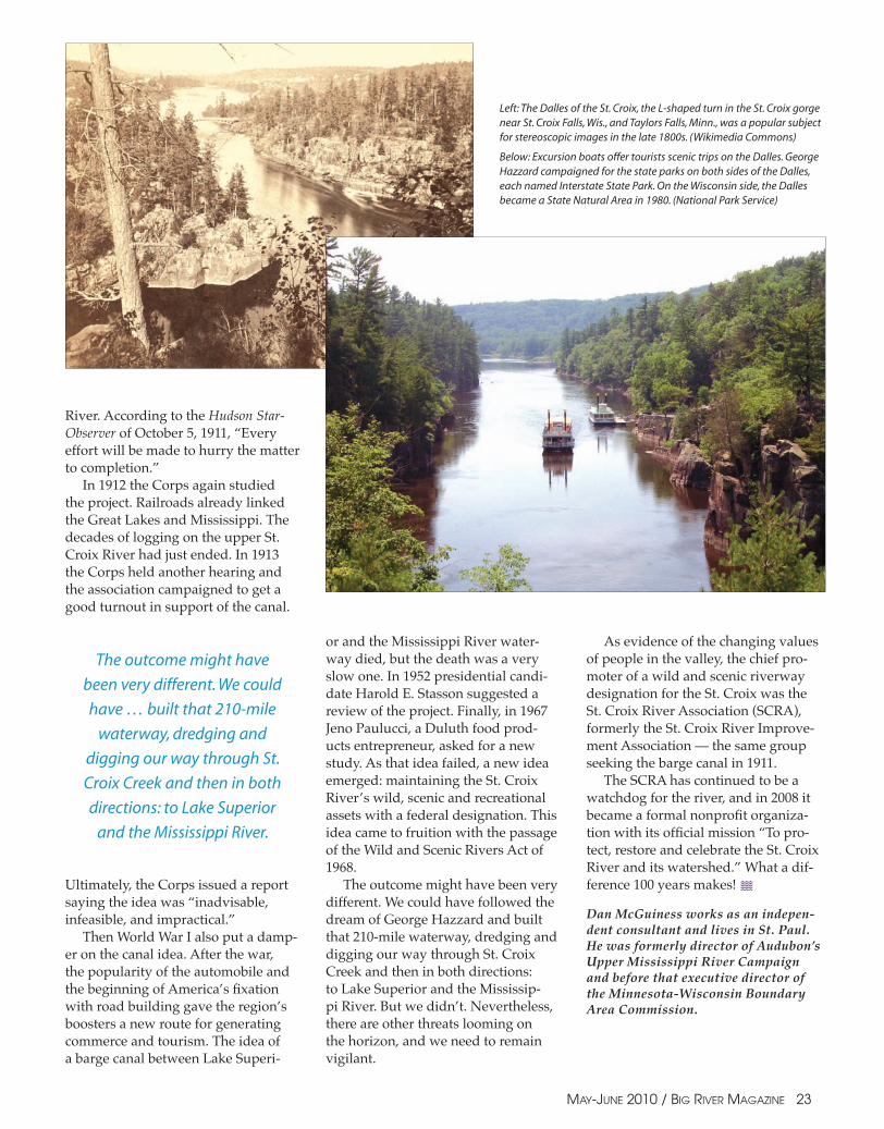
Below: Excursion boats offer tourists scenic trips on the Dalles. George Hazzard campaigned for the state parks on both sides of the Dalles, each named Interstate State Park. On the Wisconsin side, the Dalles became a State Natural Area in 1980. (National Park Service)
The outcome might have
been very different. We could
have … built that 210-mile
waterway, dredging and
digging our way through St.
Croix Creek and then in both
directions: to Lake Superior
and the Mississippi River.
May-June 2010 / Big RiveR Magazine ��