Embed Size (px)
Citation preview

Transport for New South Wales
Lindfield Substation Review of Environmental Factors
22 July 2014


Parsons Brinckerhoff | 2176502A-TPT-RPT-7620-RevC | Final i
Transport for New South Wales Lindfield Substation Review of Environmental Factors
Contents
Page number
Glossary vii
Executive summary xi
1. Introduction 1
1.1 Overview of the proposal 1
1.1.1 Background and need for the proposal 1
1.1.2 Proposal site and location of the proposal 1
1.1.3 Existing environment 5
1.1.4 Key features of the proposal 9
1.1.5 Proponent and delivery 9
1.2 Structure and content of the REF 10
2. Statutory and planning considerations 11
2.1 NSW legislation and regulations 11
2.1.1 Environmental Planning and Assessment Act 1979 11
2.2 NSW Government policies and strategies 13
2.2.1 NSW 2021 – State Plan 13
2.2.2 NSW Long Term Transport Master Plan and Sydney’s Rail Future 13
2.2.3 State Infrastructure Strategy 14
2.3 Other relevant environmental planning instruments 14
2.3.1 State environmental planning policies (SEPPs) 14
2.3.2 Approvals under other NSW legislation 17
2.4 Commonwealth legislation 20
2.4.1 (Commonwealth) Environment Protection and Biodiversity Conservation
Act 1999 20
3. Community and stakeholder consultation 21
3.1 Consultation objectives 21
3.2 Consultation during REF exhibition 21
3.2.1 Engagement activities and tools 21
3.2.2 Consultation with government agencies 22
3.3 Consultation activities proposed during public exhibition 22
3.4 Submissions report 23
3.5 Post-determination consultation activities 23

ii Parsons Brinckerhoff | 2176502A-TPT-RPT-7620-RevC | Final
Transport for New South Wales Lindfield Substation Review of Environmental Factors
Contents (Continued)
Page number
4. Options development and selection 25
4.1 Substation options 25
4.1.1 Options considered 25
4.1.2 Options assessment 27
4.1.3 Preferred option (option 4) 28
5. Description of the proposal 29
5.1 Overview of the proposed works 29
5.2 Components of the proposal 30
5.2.1 Substation built form and layout 30
5.2.2 High voltage line realignment 37
5.2.3 Signalling services route realignment 37
5.2.4 Aerial earth wire 40
5.2.5 Utilities realignment 41
5.2.6 Substation equipment 42
5.3 General construction approach 42
5.3.1 Construction plant and equipment 46
5.3.2 Workforce and working hours 47
5.3.3 Traffic management and construction access 47
5.3.4 Potential site compounds and storage 48
5.4 Operation and maintenance 48
5.4.1 Commissioning 48
5.4.2 Operational access 49
5.4.3 Ongoing maintenance of the substation and feeder lines 49
6. Environmental impact assessment 51
6.1 Traffic and transport 51
6.1.1 Existing traffic and transport environment 51
6.1.2 Traffic and transport impacts during construction 52
6.1.3 Traffic and transport operational impacts 56
6.1.4 Management and mitigation measures 56
6.2 Noise and vibration 57
6.2.1 Methodology 57
6.2.2 Existing noise environment 58
6.2.3 Noise and vibration guidelines 60
6.2.4 Noise and vibration impacts during construction 62
6.2.5 Noise and vibration impacts during operation 64
6.2.6 Management and mitigation measures 65

Parsons Brinckerhoff | 2176502A-TPT-RPT-7620-RevC | Final iii
Transport for New South Wales Lindfield Substation Review of Environmental Factors
Contents (Continued)
Page number
6.3 Landscape and visual character 66
6.3.1 Methodology 66
6.3.2 Existing landscape and visual environment 67
6.3.3 Landscape and visual impacts during construction 69
6.3.4 Landscape and visual impacts during operation 70
6.3.5 Management and mitigation measures 72
6.4 Biodiversity 74
6.4.1 Methodology 74
6.4.2 Existing environment 75
6.4.3 Potential impacts on biodiversity from on the substation site 78
6.4.4 Management and mitigation measures 80
6.5 Land use, property and socio-economic 81
6.5.1 Existing environment 81
6.5.2 Operational impacts 87
6.5.3 Management and mitigation measures 87
6.6 Water quality, hydrology, drainage 87
6.6.1 Existing environment 87
6.6.2 Construction impacts 87
6.6.3 Operational impacts 88
6.6.4 Management and mitigation measures 88
6.7 Soils and contamination 89
6.7.1 Existing environment 89
6.7.2 Construction impacts 89
6.7.3 Operational impacts 89
6.7.4 Management and mitigation measures 90
6.8 Non-Indigenous heritage 91
6.8.1 Methodology 91
6.8.2 Existing non-Indigenous heritage 91
6.8.3 Assessment of archaeological and research potential 99
6.8.4 Impacts on non-Indigenous heritage 100
6.8.5 Management and mitigation measures 103
6.9 Aboriginal heritage 103
6.9.1 Methodology 103
6.9.2 Existing Aboriginal heritage 104
6.9.3 Potential Aboriginal heritage impacts 105
6.9.4 Management and mitigation measures 105
6.10 Waste and resource management 105
6.10.1 Construction impacts 106
6.10.2 Operational impacts 106
6.10.3 Management and mitigation measures 107

iv Parsons Brinckerhoff | 2176502A-TPT-RPT-7620-RevC | Final
Transport for New South Wales Lindfield Substation Review of Environmental Factors
Contents (Continued)
Page number
6.11 Air quality 107
6.11.1 Existing air quality 107
6.11.2 Potential air quality impacts during construction 108
6.11.3 Potential air quality impacts during operation 109
6.11.4 Management and mitigation measures 109
6.12 Greenhouse gases 110
6.12.1 Existing environment 110
6.12.2 Construction impacts 111
6.12.3 Operational impacts 111
6.12.4 Management and mitigation measures 112
6.13 Electric and magnetic fields 113
6.14 Sustainability 114
6.15 Cumulative impacts 115
6.15.1 Overview 115
6.15.2 Potential developments 115
6.15.3 Construction cumulative impacts 115
6.15.4 Operational cumulative impacts 116
6.15.5 Management and mitigation measures 116
7. Environmental management 117
7.1 Environmental management plans 117
7.1.1 Construction environmental management framework 117
7.1.2 Construction environmental management plan 117
7.1.3 Operational environmental management 118
7.2 Management and mitigation measures 118
7.2.1 Construction management 118
7.2.2 Operational management 124
8. Justification and conclusion 125
8.1 Justification for the proposal 125
8.2 Ecologically sustainable development considerations 125
8.3 Clause 228 considerations 126
8.4 Consideration of matters of national environmental significance 130
8.5 Significance of the environmental impacts 131
8.6 Conclusion 131
9. References 133

Parsons Brinckerhoff | 2176502A-TPT-RPT-7620-RevC | Final v
Transport for New South Wales Lindfield Substation Review of Environmental Factors
List of tables
Page number
Table 1.1 Structure and content of the REF 10
Table 3.1 Key community and stakeholder engagement tools and activities 21
Table 6.1 Construction traffic generation 52
Table 6.2 Sensitive Receivers near the substation site 58
Table 6.3 Summary of unattended noise logging 58
Table 6.4 Summary of attended noise monitoring results 59
Table 6.5 INP amenity noise levels for suburban residential receivers 62
Table 6.6 Quantitative construction scenarios 62
Table 6.7 Construction NMLs – residential receivers 62
Table 6.8 Predicted daytime exceedences with no mitigation 63
Table 6.9 Safe working distances – cosmetic damage (based on 7.5 mm/s screening level) 64
Table 6.10 Base case assessment of the Lindfield substation, night-time 64
Table 6.11 Assessment of circuit breakers 65
Table 6.12 Summary of potential social and economic impacts during construction 67
Table 6.13 Visual sensitivity of viewpoint 70
Table 6.14 Magnitude of visual change 70
Table 6.15 Magnitude of visual change 72
Table 6.16 Potential impacts and loss of native vegetation within the proposal site 78
Table 6.17 Summary of potential social and economic impacts during construction 86
Table 6.18 Summary of non-Indigenous heritage listed items within the study area 93
Table 6.19 Potential heritage constraints of the proposal 102
Table 6.20 Potential heritage constraints of the proposal 102
Table 6.21 Emission scopes and sources 110
Table 7.1 Construction environmental management measures 118
Table 7.2 Operational environmental management measures 124
Table 8.1 Adherence with the principles of ESD 126
Table 8.2 Clause 228 considerations 126
Table 8.3 Checklist of EPBC Act matters 130
List of figures
Page number
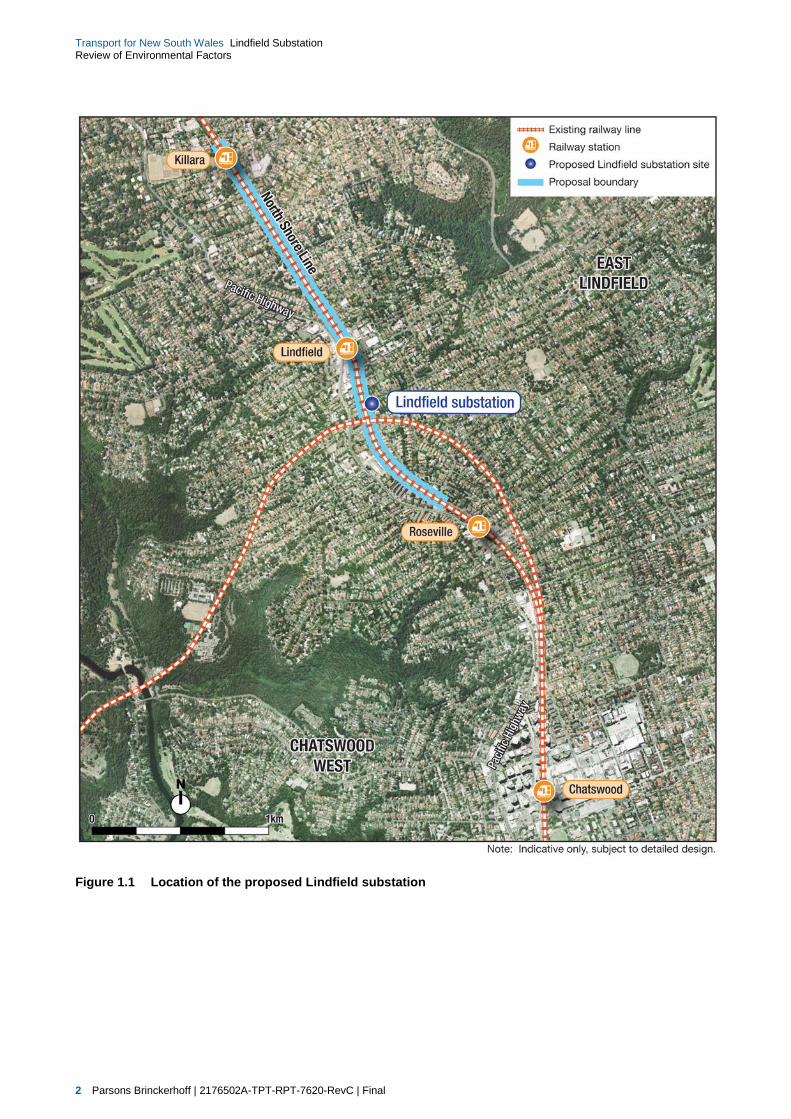
Figure 1.1 Location of the proposed Lindfield substation 2
Figure 1.2a Proposal boundary 3
Figure 1.3 View of the proposed substation site looking north from Strickland Avenue 5
Figure 1.4 View of the northern end of the proposed substation site looking north from within
the site 6
Figure 1.5 View of the proposed substation site looking west towards the existing site
entrance from Lindfield Avenue 6
Figure 1.6 View of the proposed substation site looking west towards the proposed new
entrance from Lindfield Avenue 7
Figure 1.7 View of the proposed substation site looking east from Strickland Avenue 7
Figure 1.8 Typical example of the proposal site to the south of the substation site for the
installation of the new combined services route, south of the Strickland Road
Bridge 8
Figure 1.9 Typical example of the southern end of the proposal site for the installation of the
new combined services route, to the north of Clanville Road 8
Figure 2.1 Planning approvals process for the proposal 12

vi Parsons Brinckerhoff | 2176502A-TPT-RPT-7620-RevC | Final
Transport for New South Wales Lindfield Substation Review of Environmental Factors
Figure 4.1 Location of proposed traction substation site options 26
Figure 5.1 Indicative layout of the proposed Lindfield substation 32
Figure 5.2 Indicative elevation of the proposed Lindfield substation looking west (south to left
of page) 33
Figure 5.3 Indicative elevation of the proposed Lindfield substation looking south (east to left
of page) 34
Figure 5.4 Indicative visual perspective of the proposed Lindfield substation looking north from
the intersection of Strickland Road and Lindfield Avenue 35
Figure 5.5 Indicative visual perspective of the proposed Lindfield substation looking south
along Lindfield Avenue 36
Figure 5.6a Proposed aerial earth wire and realignment of high voltage aerial feeder lines 38
Figure 5.7 Example of a typical aerial earth wire arrangement on the top of an existing power
pole 40
Figure 6.1a Proposed access and heavy vehicle haulage route to the proposal site 54
Figure 6.2 Noise monitoring location and sensitive receivers adjacent to the proposed
substation site 59
Figure 6.3 Key viewpoints and photomontage locations 69
Figure 6.4a Vegetation types 76
Figure 6.5 Example of low density residential housing to the south of the proposal site 82
Figure 6.6 Example of medium density residential housing to the west of the proposal site 82
Figure 6.7 Example of the medium density residential housing which overlooks the proposal
site to the west 83
Figure 6.8 Example of the medium density residential housing which overlooks the proposal
site to the west 83
Figure 6.9a Key land use within the vicinity of the proposal site 84
Figure 6.10a Identified heritage sites within the vicinity of the proposal site 97
List of appendices
Appendix A Construction environmental management framework
Technical Paper 1 Traffic and transport impact assessment
Technical Paper 2 Noise and vibration impact assessment
Technical Paper 3 Visual impact assessment
Technical Paper 4 Ecological impact assessment
Technical Paper 5 Non-Indigenous cultural heritage impact assessment
Technical Paper 6 Aboriginal archaeological impact assessment

Parsons Brinckerhoff | 2176502A-TPT-RPT-7620-RevC | Final vii
Transport for New South Wales Lindfield Substation Review of Environmental Factors
Glossary
AC alternating current
AHIMS Aboriginal Heritage Information Management System
AHIP Aboriginal Heritage Impact Permit
ARPANSA Australian Radiation Protection and Nuclear Safety Agency
BoM Bureau of Meteorology
CBD central business district
CEMF Construction Environmental Management Framework
CEMP Construction Environmental Management Plan
CO carbon monoxide
CSR A combined services route (CSR) is a technical railway term used to described
the buried pipe or enclosed box (typically a steel box fixed to a pole
approximately one metre high) that holds the signalling, communication and
electrical cables running along the railway corridor
CPTED crime prevention through environmental design
CNVS construction noise vibration strategy
dB decibel
DC direct current
DCP Development Control Plan
DECC Department of Environment Climate Change
DECCW Department of Environment Climate Change and Water
DMP dust management plan
Down-track Refers to the line on which trains travel away from Sydney away from
Chatswood Station and the Sydney CBD towards Lindfield Station
DP&E (NSW) Department of Planning and Environment
Draft Strategy Draft Metropolitan Strategy for Sydney 2031
ECRL Epping to Chatswood Rail Link
EIS Environmental Impact Statement
EP&A Act (NSW) Environmental Planning and Assessment Act 1979

viii Parsons Brinckerhoff | 2176502A-TPT-RPT-7620-RevC | Final
Transport for New South Wales Lindfield Substation Review of Environmental Factors
EP&A Regulation (NSW) Environmental Planning and Assessment Regulation 2000
EPA (NSW) Environment Protection Authority
EPBC Act (Commonwealth) Environment Protection and Biodiversity Conservation Act
1999
EPL environment protection licence
ESCP erosion and sediment control plan
ESD ecologically sustainable development
EMP Environmental Management Plan
fugitive dust dust derived from a mixture of sources (non-point source) or not easily defined
sources. Examples of fugitive dust include dust from vehicular traffic on unpaved
roads, materials transport and handling, and un-vegetated soils and surfaces
GST galvanised steel troughing
GLT ground level troughing
HCA heritage conservation area
Heritage Act (NSW) Heritage Act 1977
ICNG Interim Construction Noise Guideline
ICNIRP International Commission on Non-Ionizing Radiation protection
Infrastructure SEPP State Environmental Planning Policy (Infrastructure) 2007
INP Industrial Noise Policy
IRCSs isolating and rail connecting switches
km Kilometres
Ku-Ring-Gai LEP Ku-Ring-Gai Local Environmental Plan (Local Centres) 2012
Ku-Ring-Gai PSO Ku-Ring-Gai Planning Scheme Ordinance 2013
LEP Local Environmental Plan
LPG liquid petroleum gas
LGA local government area
kV kilovolt
MNES Matters of National Environmental Significance
Metropolitan Plan Metropolitan Plan for Sydney 2036
MLALC Metropolitan Local Aboriginal Land Council

Parsons Brinckerhoff | 2176502A-TPT-RPT-7620-RevC | Final ix
Transport for New South Wales Lindfield Substation Review of Environmental Factors
Native Vegetation Act (NSW) Native Vegetation Act 2003
NEPM National Environment Protection Measure
NOx oxides of nitrogen
Noxious Weeds Act (NSW) Noxious Weeds Act 1993
NPI National Pollution Inventory
NSW New South Wales
NSW 2021 NSW 2021: A plan to make NSW number one
NWRL North West Rail Link
O3 ozone
OEH (NSW) Office of Environment and Heritage
OHW overhead wiring
PAD Potential Archaeological Deposit
PEA Act (NSW) Protection of the Environment Administration Act 1991
PM2.5 Particulate matter less than or equal to 2.5 µm in aerodynamic diameter
PM10 Particulate matter less than or equal to 10 µm in aerodynamic diameter
PoEO Act (NSW) Protection of the Environment Operations Act 1997
PSO Planning Scheme Ordinance
RBL rating background level
REF Review of Environmental Factors
REP Regional Environmental Plan (now deemed SEPP)
RNP Road Noise Policy (DECCW, 2011)
Roads Act (NSW) Roads Act 1993
Roads and Maritime (NSW) Roads and Maritime Services
SEPP State Environmental Planning Policy
RTU remote terminal unit
SCADA supervisory control and data acquisition
SEPP 19 – Urban
Bushland
State Environmental Planning Policy No. 19 – Bushland in Urban Areas
SEPP 55 – Remediation
of Land
State Environmental Planning Policy No 55 – Remediation of Land

x Parsons Brinckerhoff | 2176502A-TPT-RPT-7620-RevC | Final
Transport for New South Wales Lindfield Substation Review of Environmental Factors
SHR State Heritage Register
SO2 sulphur dioxide
SoHI Statement of Heritage Impact
SREP Sydney Harbour Catchment Regional Environmental Plan
State Infrastructure
Strategy
State Infrastructure Strategy 2012–2032
Sydney Harbour
Catchment REP
Sydney Regional Environmental Plan (Sydney Harbour Catchment) 2005
Sydney’s Rail Future Sydney’s Rail Future Modernising Sydney’s Trains
TMP traffic management plan
Transport for NSW Transport for New South Wales
Transport Master Plan NSW Long Term Transport Master Plan
TSC Act (NSW) Threatened Species Conservation Act 1995
TSP total suspended particles
g micrograms
Up-track Refers to the line on which a train travels toward the city away from Lindfield
Station towards Chatswood Station and the Sydney CBD

Parsons Brinckerhoff | 2176502A-TPT-RPT-7620-RevC | Final xi
Transport for New South Wales Lindfield Substation Review of Environmental Factors
Executive summary
Lindfield substation works
In future, Sydney Trains intends to operate increasing train services on the North Shore Line. A new traction
power substation is required to allow for this increase in capacity and will support the delivery of the North
West Rail Link. Therefore, a new substation is proposed to be constructed at Lindfield to supply the North
Shore Line. The proposal also includes ancillary electrical works generally between Killara Station and the
Clanville Road overbridge in Lindfield.
The substation site (where the substation would be constructed) is located on Lindfield Avenue at the
intersection with Strickland Avenue in Lindfield, approximately 300 metres to the south of Lindfield Station.
The site is within the existing rail corridor between the North Shore Line up-track (i.e. travelling towards
Sydney central business district (CBD)) and Lindfield Avenue. In addition, the works comprise ancillary
electrical works, including the installation of aerial earth wires to existing power poles generally between
Killara Station and Russell Avenue, Lindfield and the realignment of existing overhead wiring generally
between Russell Avenue and the Clanville Road overbridge.
The key features of the proposal are:
construction and operation of a new traction power substation at Lindfield in order to continue to power
the Sydney Trains network (in particular the North Shore Line). Components of the substation would
generally include:
construction of two new rectifier transformers
installation of switchgear room containing switchgear and switchboards, batteries and changers,
voice and data communications equipment
installation of the rectifier and reactor unit(s)
office and associated facilities
earthworks and construction of a retaining wall on the western side of the substation site, adjacent
to the rail line
realignment of the existing 33 kilovolt (kV) and 11 kV overhead wiring (OHW), to a new combined
services route (CSR), generally between power pole P57 (to the south of Lindfield Station near the
intersection with Russell Avenue, Lindfield and power pole P49 (to the north of the Clanville Road
overbridge)
relocation and installation of signalling cable and communication cable to the substation to connect with
existing cables along the North Shore Line
construction of a new driveway access to the substation site from Lindfield Avenue and a paved surface
area to provide car parking for approximately four vehicles within the proposed substation compound
security and permanent maintenance lighting within and external to the building
landscaping and vegetation surrounding the proposed substation building, generally to the east and
south of the site
installation of feeder and return cabling to the OHW system on the North Shore Line
installation of an aerial earth wire to the top of the existing (Sydney Trains) power poles, generally
between Killara Station and Russell Avenue, Lindfield
relocation of street lighting and power routes to provide access to the substation for construction and
maintenance (including future replacement of substation equipment).

xii Parsons Brinckerhoff | 2176502A-TPT-RPT-7620-RevC | Final
Transport for New South Wales Lindfield Substation Review of Environmental Factors
Minor enabling works are expected to be undertaken in late 2014. Service relocation will commence in mid-
2015 with construction of the substation expected to commence in early 2016 (subject to Transport for
NSW’s determination of this Review of Environmental Factors (REF)) with testing and commissioning
anticipated in August 2017. The substation site is expected to be handed over to Sydney Trains in late 2017.
Key environmental impacts of the proposal
This REF assesses the construction and operational environmental impacts of a proposed traction substation
at Lindfield. The key potential impacts associated with the proposal would likely comprise:
Vegetation removal — construction of the proposed substation and associated cabling at Lindfield
would require the removal of up to approximately 0.94 hectares of native vegetation being a
combination of Blue Gum High Forest and Sydney Turpentine Ironbark Forest scrubby regrowth.
Up to approximately 2.31 hectares of habitat would be removed which is of low to moderate condition
and may provide some marginal foraging habitat for several threatened species of birds and bats.
Significance assessments have been undertaken for threatened biodiversity which have concluded that
due to the small area and highly modified condition of the vegetation and habitat recorded within the
study area, the proposed substation construction is not likely to have a significant impact on any
threatened biodiversity, nor would it interfere with their recovery, assuming appropriate mitigation
measures are implemented. Based on the assumption that the ‘additional aerial earth (overhead) wires
only’ section of the proposed will require the removal of vegetation to the north of Lindfield Station
construction of the proposed substation at Lindfield will require the removal of 2.31 hectares of potential
foraging habitat for these species. In the likelihood that power poles are not replaced as part of the
proposed this area of vegetation removed will be reduced. However, if required, offsetting would be
undertaken in alignment with Transport for NSW offsetting guidelines (Transport for NSW, 2014) during
detailed design.
Construction noise — the proposal would result in construction noise and vibration impacts within the
local area at a range of residential receivers during specific activities. There may be some short-term
exceedances of the construction noise criteria (including the use of rock breaking equipment and the
placement of plant and equipment) in addition to during out-of-hours works. These exceedances are
expected to be short-term in duration and all feasible and reasonable practices would be applied to
minimise noise impacts to the local community during these periods. In the event of the need for out-of-
hours works, the contractor would be required to discuss the proposed works with the (NSW)
Environment Protection Authority (EPA) and notify local residents and businesses prior to the proposed
works occurring. Mitigation measures put in place during construction would reduce the predicted noise
levels to within an acceptable range.
Operational noise – some noise impacts may occur to sensitive receivers adjacent to the proposal site.
The predicted base case steady state noise levels have been identified as resulting in a worst-case
11 dB exceedance of the night-time intrusive goal at the nearest sensitive receivers (without mitigation).
The predicted LA1(60second) noise levels also exceed the sleep disturbance goals at the nearest residential
receiver locations by up to 16 dB. It should be noted, however, that the predicted noise level from circuit
breaker operation will not occur on a continuous basis and will likely be a very infrequent occurrence
during the night-time period – potentially once or twice a month.
Whilst this exceedance has been predicted to be moderate, it is expected that the substation can be
readily designed (during the detailed design stage of the proposal) to meet the noise goals through
provision of shielding or consideration of the acoustic performance of the enclosure during detailed
design of the structure. Mitigation measures would be put in place to reduce the predicted noise levels
to within an acceptable range during operation of the substation.
Parsons Brinckerhoff | 2176502A-TPT-RPT-7620-RevC | Final xiii
Transport for New South Wales Lindfield Substation Review of Environmental Factors
Visual – the landscape and visual impacts would generally be restricted to a small number of localised
viewing locations to the site as a result of the introduction of a new structure and the removal of some
existing screening. This potentially increases the visibility of the substation and existing train
movements along the rail corridor. Some improvement to the existing visual landscape would occur as a
result of the removal of overhead wiring generally between power pole P57 (south of Lindfield Station
near Russell Avenue) and power pole P49 (north of the Clanville Road overbridge). Landscape and
visual impacts would occur during both the construction and operational phases. However, the
proposed landscape planting would partially screen the outer sides of the building from views from the
surrounding areas.
Construction traffic — some limited traffic impacts may occur during the construction of the proposed
substation and associated cabling, including some increase in heavy vehicle movements and the
potential for limited road closures during the delivery of primary equipment such as transformer and
reactor units.
An assessment of each of the above, and other environmental issues associated with the proposal, is
provided in the body of this REF.
It is considered that the potential adverse environmental impacts are generally localised in nature. With the
adoption and implementation of the proposed mitigation measures and commitments specified in Chapter 8,
the potential environmental impacts of the proposal could be adequately mitigated and managed, and are
not considered to be significant.
Next steps
Transport for NSW will exhibit the REF for a period of 10 business days to enable the community to provide
written comments on the proposal.
A range of stakeholder and community consultation activities would be undertaken as part of the public
exhibition. Additional stakeholder and community consultation would continue to be implemented to inform
the community and stakeholders about the proposal throughout the detailed design and construction of the
project (should it be approved during the determination phase).
At the close of the exhibition period, Transport for NSW will consider the submissions received in response
to the REF. A submissions report would be prepared to address and respond to the issues raised in the
submissions. This report, along with the REF and any other relevant information, would be used by Transport
for NSW to assess and determine the proposal.
Should the proposal be approved, Transport for NSW would make the submissions report and any
conditions of approval publicly available. The local community would be notified by way of advertisements
in local newspapers, community newsletters and the Transport for NSW website www.transport.nsw.gov.au/projects. Correspondence would also be sent to people who make a submission which would include contact details for further information and an indication of the anticipated timing of construction work.


Parsons Brinckerhoff | 2176502A-TPT-RPT-7620-RevC | Final 1
Transport for New South Wales Lindfield Substation Review of Environmental Factors
1. Introduction
1.1 Overview of the proposal
This section provides an overview of the proposal that is the subject of this Review of Environmental Factors
(REF). A more detailed description of the proposal is provided in Chapter 5.
1.1.1 Background and need for the proposal
The NSW Government has developed a plan to transform and modernise Sydney’s rail network so that it can
grow with the city’s population and meet the needs of customers into the future. The NSW Government has
identified that Sydney’s rail system is reaching the limits of its capacity. For example, at present there are
parts of the network where 20 trains are scheduled to run in the busiest peak hour but often only 17 trains
actually arrive during that period (NSW Government 2012b).
In future, Sydney Trains intends to operate increasing train services on the North Shore Line. A new traction
power substation is required to allow for this increase in capacity and will support the delivery of the North
West Rail Link (NWRL). Therefore, a new substation is proposed to be constructed at Lindfield to supply the
North Shore Line.
1.1.2 Proposal site and location of the proposal
For the purposes of this assessment, the following definitions are used:
The ‘proposal site’ refers to the area that would be directly impacted by the proposal. The location of the
proposal site is shown on Figure 1.2 and would encompasses two main components consisting of the
following:
the ‘substation site’ (where the substation would be constructed)
the ‘electrical works site’ (comprising an area of associated electrical works, generally between
Killara Station, in Lindfield, in the north and the Clanville Road, Lindfield overpass in the south)
The ‘study area’ encompasses the proposal site and the area that may be indirectly impacted by the
proposal. This area can vary in size depending on the environmental issue being discussed (e.g.
biodiversity, heritage etc.) and the specific area for each issue is described in the relevant section of
Chapter 6.
The proposal site lies wholly within the Ku-Ring-Gai local government area (LGA) and is surrounded by
developed urban areas and the Sydney Trains’ North Shore Line to the west. The site is predominantly
surrounded by residential development to the east, west and south of the proposal site. The main town
centre of Lindfield, including light industrial and commercial uses, is located to the north of the site (refer to
Figure 1.1).
The substation site is located on Lindfield Avenue, at its intersection with Strickland Avenue in Lindfield,
approximately 300 metres to the south of Lindfield Station. The substation site is within the existing rail
corridor between the North Shore Line up-track (i.e. travelling towards Sydney central business district
(CBD)) and Lindfield Avenue. Figure 1.2 shows the location of the overall proposal site, including the
substation site and the electrical works site.
2 Parsons Brinckerhoff | 2176502A-TPT-RPT-7620-RevC | Final
Transport for New South Wales Lindfield Substation Review of Environmental Factors
Figure 1.1 Location of the proposed Lindfield substation

Parsons Brinckerhoff | 2176502A-TPT-RPT-7620-RevC | Final 3
Transport for New South Wales Lindfield Substation Review of Environmental Factors
Figure 1.2a Proposal boundary

4 Parsons Brinckerhoff | 2176502A-TPT-RPT-7620-RevC | Final
Transport for New South Wales Lindfield Substation Review of Environmental Factors
Figure 1.2b Proposal boundary

Parsons Brinckerhoff | 2176502A-TPT-RPT-7620-RevC | Final 5
Transport for New South Wales Lindfield Substation Review of Environmental Factors
1.1.3 Existing environment
The overall proposal site forms part of the operational rail corridor generally between Killara Station and the
Clanville Road overbridge. It is adjacent to a residential area which consists of a mix of low and medium
density residential dwellings. Lindfield town centre is also located to the north of the main substation site.
Further details of surrounding land uses are provided in section 6.5. The substation site is currently accessed
via an existing gate located off Lindfield Avenue (further details of the surrounding road network are located
in section 6.1). Other parts of the proposal site are accessed by a series of existing Sydney Train access
gates along the rail corridor (described in greater detail in section 6.1).
The proposal site contains vegetation that generally consists of weeds or introduced species. This railway
corridor has been greatly disturbed as a result of the existing infrastructure (railway line), however some
portions of Sydney Turpentine Ironbark Forest and Blue Gum High Forest derived from scrubby regrowth
vegetation communities have been identified within the wider proposal site (further details of flora and fauna
are located in section 6.4). To the north and south of the substation site, the corridor is predominately
cleared and consists of a mixture of grassed and gravel surfaces which provide access along the corridor
towards the north.
There are no surface waterways that have been located within close proximity to the proposal site.
The existing site is shown in Figures 1.3 to 1.9 below.
Figure 1.3 View of the proposed substation site looking north from Strickland Avenue
Source: Envisage consulting, 2014

6 Parsons Brinckerhoff | 2176502A-TPT-RPT-7620-RevC | Final
Transport for New South Wales Lindfield Substation Review of Environmental Factors
Figure 1.4 View of the northern end of the proposed substation site looking north from within the site
Source: Parsons Brinckerhoff, 2014
Figure 1.5 View of the proposed substation site looking west towards the existing site entrance from Lindfield Avenue
Source: Envisage consulting, 2014

Parsons Brinckerhoff | 2176502A-TPT-RPT-7620-RevC | Final 7
Transport for New South Wales Lindfield Substation Review of Environmental Factors
Figure 1.6 View of the proposed substation site looking west towards the proposed new entrance from Lindfield Avenue
Source: Envisage consulting, 2014
Figure 1.7 View of the proposed substation site looking east from Strickland Avenue
Source: Envisage consulting, 2014

8 Parsons Brinckerhoff | 2176502A-TPT-RPT-7620-RevC | Final
Transport for New South Wales Lindfield Substation Review of Environmental Factors
Figure 1.8 Typical example of the proposal site to the south of the substation site for the installation of the new combined services route, south of the Strickland Road Bridge
Source: Transport for NSW, 2014
Figure 1.9 Typical example of the southern end of the proposal site for the installation of the new combined services route, to the north of Clanville Road
Source: Transport for NSW, 2014
Parsons Brinckerhoff | 2176502A-TPT-RPT-7620-RevC | Final 9
Transport for New South Wales Lindfield Substation Review of Environmental Factors
1.1.4 Key features of the proposal
The proposal comprises the construction of a new substation building, and installation of associated wiring,
cabling and substation equipment. The key features of the proposal would comprise:
construction and operation of a new traction power substation at Lindfield in order to continue to power
the Sydney trains network (in particular the North Shore Line). Components of the substation would
generally include:
construction of two new rectifier transformers
installation of switchgear room containing switchgear and switchboards, batteries and changers,
voice and data communications equipment
installation of the rectifier and reactor unit(s)
office and associated facilities
realignment of the existing 33 kilovolt (kV) and 11 kV overhead wiring (OHW), to a new combined
services route (CSR) generally between power pole P57 (to the south of Lindfield Station near the
intersection with Russell Avenue) and power pole P49 (to the north of the Clanville Road overbridge)
relocation and installation of signalling cable and communication cable to the substation to connect with
existing cables along the North Shore Line
construction of a new driveway access to the substation site from Lindfield Avenue and a paved surface
area to provide for car parking for approximately four vehicles within the proposed substation compound
lighting within and external to the building would consist of security and permanent maintenance lighting
landscaping and vegetation surrounding the proposed substation building, generally to the east and
south of the substation
installation of feeder and return cabling to the OHW system on the North Shore Line
installation of an aerial earth wire to the top of the existing (Sydney Trains) poles, generally between
Russell Avenue, Lindfield and Killara Station
relocation of street lighting and power routes to provide access to the substation for construction and
maintenance (including future replacement of substation equipment).
Minor enabling works are expected to be undertaken in late 2014. Service relocation will commence in mid-
2015 with construction of the substation expected to commence in early 2016 (subject to Transport for
NSW’s determination of this REF) with testing and commissioning anticipated in August 2017.
The substation site is expected to be handed over to Sydney Trains in late 2017.
1.1.5 Proponent and delivery
The construction of the Lindfield traction substation and associated electrical works would be undertaken by
a contractor engaged by Transport for NSW. At the award of the works package, the proposal site would be
occupied by the contractor, who will carry out all activities required for its work including site clearing and
excavation, relocation of affected utility services, construction and fit-out of the substation, including
associated works such as high voltage cable relocations, signalling equipment relocations, testing and
commissioning and all remaining works such as landscaping and site restoration.
At the completion of the works package, the substation and proposal site would be handed over to Sydney
Trains for operation of the substation.

10 Parsons Brinckerhoff | 2176502A-TPT-RPT-7620-RevC | Final
Transport for New South Wales Lindfield Substation Review of Environmental Factors
1.2 Structure and content of the REF
The structure and content of the REF is outlined in Table 1.1.
Table 1.1 Structure and content of the REF
Chapter Description
Chapter 1 – Introduction Outlines the background of the proposal and need for the proposal.
Chapter 2 – Statutory and planning considerations
Outlines the relevant environmental planning instruments and policies and provides an assessment of their relevance to the proposal.
Chapter 3 – Community and stakeholder engagement
Outlines how the community and stakeholders have been, and will continue to be, involved in the proposal’s development, assessment and construction phases. This chapter also summaries the issues raised by stakeholders during the preparation of the REF.
Chapter 4 – Options development and selection
Provides an overview of the options that were considered during the selection of the site for the Lindfield traction substation and the methodology that was used to select the preferred option.
Chapter 5 – Proposal description
Provides a detailed description of the proposal, including the elements of the proposal, and construction, operation and maintenance of the proposed substation.
Chapter 6 – Environmental impact assessment
Provides an assessment of the potential impacts of the proposal on traffic and transport, noise and vibration, Aboriginal heritage, non-Indigenous heritage, air quality, biodiversity, soils, hydrology and water quality, sustainability, visual, resource use, utilities and waste management and cumulative impacts.
Chapter 7 – Environmental management and mitigation
Outlines the proposed environmental management systems to be implemented and provides the management and mitigation measures during the construction, operation and maintenance of the proposed substation, to manage the impacts identified in the REF.
Chapter 8 – Justification and conclusion
Provides the justification for the proposal and an outline of the key conclusions of this report.
The REF is supported by six technical papers, which provide detailed assessment of specific environmental
issues associated with the proposal. These technical papers form appendices to the REF and have been
used to inform the REF, as follows:
Technical Paper 1 – Traffic and transport impact assessment (Parsons Brinckerhoff)
Technical Paper 2 – Noise and vibration impact assessment (SLR Consulting)
Technical Paper 3 – Visual impact assessment (Envisage)
Technical Paper 4 – Ecological impact assessment (Parsons Brinckerhoff)
Technical Paper 5 – Non-Indigenous cultural heritage impact assessment (Artefact Heritage)
Technical Paper 6 – Aboriginal archaeological impact assessment (Artefact Heritage).

Parsons Brinckerhoff | 2176502A-TPT-RPT-7620-RevC | Final 11
Transport for New South Wales Lindfield Substation Review of Environmental Factors
2. Statutory and planning considerations
This chapter outlines the statutory requirements and explains the environmental planning process and
approvals process for the construction and operation of the proposed traction substation and associated
electrical works at Lindfield (‘the proposal’). The environmental planning instruments relevant to the
construction and operation of the proposed substation are also outlined.
2.1 NSW legislation and regulations
2.1.1 Environmental Planning and Assessment Act 1979
The proposal comprises an ‘activity’ for the purposes of Part 5 of the (NSW) Environmental Planning and
Assessment Act 1979 (EP&A Act) by reason of clause 79 of State Environmental Planning Policy
(Infrastructure) 2007 (the Infrastructure SEPP). Specifically, Clause 79 of the Infrastructure SEPP outlines
that development for the purpose of railways and railway infrastructure facilities, which include ‘power supply
(including overhead power supply) systems’, are permissible without the need for development consent
under Part 4 of the EP&A Act when undertaken by a public authority. Further details regarding the
Infrastructure SEPP are provided in section 2.4.1 of this REF.
As the determining authority for the purposes of Part 5 of the Act, Transport for NSW must:
examine and take into account to the fullest extent possible all matters affecting or likely to affect the
environment by reason of that activity, in accordance with Section 111 of the EP&A Act
determine whether or not the activity is likely to significantly affect the environment or is likely to
significantly affect threatened species, populations and ecological communities.
Chapter 6 of this REF assesses the likely effect of the proposal on the environment and threatened species,
populations and ecological communities. Having regard to the provisions of Sections 111 and 112 of the
EP&A Act, no significant impact on the environment or threatened species is predicted and therefore neither
an Environmental Impact Statement (EIS), nor a species impact statement is required.
Assessment and approval process under Part 5
Transport for NSW has prepared this REF, which includes appropriate mitigation measures to manage and
minimise impacts on the environment. The REF document will be exhibited and made publicly available from
28 July 2014 to 11 August 2014. During the exhibition period, the community would be encouraged to make
submissions to Transport for NSW on the proposal and information contained in the REF.
Following the exhibition period, Transport for NSW will consider issues raised in submissions and respond to
community feedback in a submissions report. If required, Transport for NSW may also propose changes to
the proposal and detail these in the submissions report. These documents will be available to the public via
the Transport for NSW website (www.transport.nsw.gov.au/projects).
Following the preparation of the submissions report, Transport for NSW will determine whether to proceed
with the proposal. If the proposal proceeds, it would be designed, constructed and operated in accordance
with the mitigation measures outlined in this REF, the submissions report and any additional conditions of
approval.

12 Parsons Brinckerhoff | 2176502A-TPT-RPT-7620-RevC | Final
Transport for New South Wales Lindfield Substation Review of Environmental Factors
The planning approvals process for the proposal under Part 5 of the EP&A Act is outlined in Figure 2.1.
Figure 2.1 Planning approvals process for the proposal
Sustainability requirements under the EP&A Act
Schedule 2 of the (NSW) Environmental Planning and Assessment Regulation 2000 (EP&A Regulation), and
Section 6(2) of the (NSW) Protection of the Environment Administration Act 1991 (PEA Act) outline the four
principles of ecologically sustainable development (ESD).
Transport for NSW is committed to ensuring that its projects are implemented in a manner that is consistent
with the principles of ESD, which are:
The precautionary principle: If there are threats of serious or irreversible damage, a lack of full scientific
uncertainty should not be used as a reason for postponing measures to prevent environmental
degradation.
Intergenerational equity: The present generation should ensure that the health, diversity and productivity
of the environment are maintained or enhanced for the benefit of future generations.
Conservation of biological diversity and ecological integrity: The diversity of genes, species, populations
and their communities, as well as the ecosystems and habitats they belong to, should be maintained or
improved to ensure their survival.
Improved valuation, pricing and incentive mechanisms: Environmental factors should be included in the
valuation of assets and services.
Transport for NSW has considered these principles and broader sustainability themes in the development of
the proposal. A discussion of how the proposal has considered the principles of ESD, including sustainability
initiatives incorporated into the proposal, is provided in section 6.14 and Chapter 8 of this REF.

Parsons Brinckerhoff | 2176502A-TPT-RPT-7620-RevC | Final 13
Transport for New South Wales Lindfield Substation Review of Environmental Factors
2.2 NSW Government policies and strategies
2.2.1 NSW 2021 – State Plan
NSW 2021: A plan to make NSW number one (NSW Government 2011; ‘NSW 2021’) is a 10-year plan to
rebuild the economy, return quality services, renovate infrastructure, restore accountability to government,
and strengthen the local environment and communities. The plan sets immediate priorities for action and
guides NSW Government resource allocation in conjunction with the NSW Budget. It replaces the former
NSW State Plan – Investing in a Better Future (NSW Government 2010a) as the NSW Government’s
strategic business plan. NSW 2021 includes 32 goals and 180 targets to frame the achievements of its
commitments.
A number of goals in NSW 2021 are specifically aimed at improving access and transport across the State.
Common aims and themes across these goals include maximising the efficiency and effectiveness of public
transport, and for active transport systems – including reducing travel times, increasing patronage,
enhancing customer experience, integration across modes and desired origin/destination points and
improving the frequency and reliability of services. The investment in critical infrastructure is also a key goal
of the plan (Goal 19).
The proposed new substation at Lindfield would assist in meeting a number of these goals by providing
ongoing and future traction power supply requirements to the existing Sydney Trains network to enable the
ongoing supply of power, in particular to the North Shore Line. This would support the broader goals of the
Plan by allowing expansion of Sydney’s rail network including the ability to run additional services during
peak periods, thereby improving the frequency and reliability of services.
2.2.2 NSW Long Term Transport Master Plan and Sydney’s Rail Future
The NSW Long Term Transport Master Plan (NSW Government 2012a; ‘Transport Master Plan’) is a 20-year
plan to improve the NSW transport system. It provides the basis upon which further detailed transport
planning, including the proposal, can be undertaken. This includes the development of Sydney’s Rail Future
(NSW Government 2012b) which aims to reform, improve and grow services on the existing Sydney Trains
network, leading to an overall capacity increase of 60 per cent.
The Transport Master Plan considers the future population growth and employment precincts within the State
(including Sydney) and outlines the capabilities and limitations of the transport network for all transport
modes (including buses, heavy rail, light rail, ferry and private vehicles) to provide clear direction for future
transport investigations.
A key element of the Transport Master Plan is the need to address congestion coming into and within the
Sydney CBD. As part of Sydney’s Rail Future, five key stages have been identified. As part of Stage 3 of the
plan, the provision of a train from Chatswood to the CBD every three minutes in peak periods is noted. In
order to support this commitment, additional trains would be required to operate along the North Shore Line.
The proposed Lindfield substation is an important component in achieving this, by providing ongoing and
future traction power supply requirements to the existing Sydney Trains network to meet the increased
service requirements.
14 Parsons Brinckerhoff | 2176502A-TPT-RPT-7620-RevC | Final
Transport for New South Wales Lindfield Substation Review of Environmental Factors
2.2.3 State Infrastructure Strategy
The NSW Government’s State Infrastructure Strategy 2012–2032 (Infrastructure NSW 2012; ‘State
Infrastructure Strategy’) sets out and commits to the State’s infrastructure delivery and reform priorities over
the next five years. The strategy is designed to complement the Transport Master Plan.
A core element of the State Infrastructure Strategy is the development of a pipeline of projects that prioritises
investment, and provides opportunities for private sector involvement in delivery and operations. The
strategy seeks to prioritise projects that maximise economic benefits for the State, while also considering the
capacity of the Government to provide funds for new projects.
The State Infrastructure Strategy supports the ongoing aim to provide reliable, frequent and fast passenger
trains as an essential part of the economic success of NSW and of the amenity of life, particularly in Global
Sydney. The construction of the proposed Lindfield substation as a means of maintaining and providing
sufficient traction power for meeting the current and future Sydney Trains requirements is considered to be
consistent with this aim.
2.3 Other relevant environmental planning instruments
The following environmental planning instruments are considered relevant to the proposal:
State Environmental Planning Policy (Infrastructure) 2007 (‘Infrastructure SEPP’)
State Environmental Planning Policy No. 19 – Bushland in Urban Areas (‘SEPP 19 – Urban Bushland’)
State Environmental Planning Policy No 55 – Remediation of Land (‘SEPP 55 – Remediation of Land’)
Sydney Regional Environmental Plan (Sydney Harbour Catchment) 2005 (‘Sydney Harbour
Catchment SREP’)
Ku-Ring-Gai Local Environmental Plan (Local Centres) 2012
Draft Ku-Ring-Gai Local Environmental Plan 2013.
Given that the Infrastructure SEPP controls the proposal, the LEPs listed above would not apply to the extent
that they are inconsistent with the Infrastructure SEPP. In light of this, the proposal’s compliance with these
instruments is considered below.
2.3.1 State environmental planning policies (SEPPs)
Infrastructure SEPP
State Environmental Planning Policy (Infrastructure) 2007 (the Infrastructure SEPP) outlines the
permissibility and development controls for infrastructure works and facilities. Specifically, clause 79 of the
Infrastructure SEPP outlines what railway facilities are permissible without the need for development consent
under the EP&A Act under Part 4 of the EP&A Act. Rail infrastructure facilities are defined in Clause 78 of
the SEPP, which includes ‘power supply (including overhead power supply) systems’ (part (c) of the
definition of ‘rail infrastructure facilities’).
The proposed Lindfield substation is therefore considered to be permissible without consent as the proposal
can be defined as a ‘rail infrastructure facility’ under the Infrastructure SEPP.

Parsons Brinckerhoff | 2176502A-TPT-RPT-7620-RevC | Final 15
Transport for New South Wales Lindfield Substation Review of Environmental Factors
SEPP 19 – Urban Bushland
State Environmental Planning Policy 19 – Urban Bushland (SEPP 19 – Urban Bushland) applies to bushland
within the urban areas identified in Schedule 1 of the SEPP, which includes the Ku-Ring-Gai LGA in which
the proposal is located. The aim of SEPP 19 – Urban Bushland is to protect and preserve bushland for its
natural heritage aesthetic, recreational, educational and scientific resource values.
Clause 7 of SEPP 19 requires public authorities (i.e. the proponent) to have regard for the aims of the policy
before deciding to disturb any remnant bushland. Notwithstanding, SEPP 19 is not applicable to the proposal
as no consent is required for the proposal under the provisions of the Infrastructure SEPP.
Additionally, under Clause 9(2) of SEPP 19 – Urban Bushland, a public authority must not grant approval to
or carry out development on land which adjoins bushland zoned or reserved for public open space unless it
has taken into account:
‘(c) the need to retain any bushland on the land,
(d) the effect of the proposed development on bushland zoned or reserved for public open space purposes and,
in particular, on the erosion of soils, the siltation of streams and waterways and the spread of weeds and
exotic plants within the bushland, and
(e) any other matters which, in the opinion of the approving or consent authority, are relevant to the protection
and preservation of bushland zoned or reserved for public open space purposes’.
The substation site at Lindfield is not located within or adjacent to land zoned or reserved for public open
space. Notwithstanding, a small amount of vegetation at the substation site would be required to be cleared
to accommodate the proposed substation. Some additional clearing would be required towards within the
southern part of the electrical works site to allow for the relocation of the existing electricity feeder cables,
generally between the substation site and Clanville Road. These impacts are discussed further in section 6.4
of this REF.
SEPP 44 – Koala Habitat Protection
State Environmental Planning Policy No. 44 – Koala Habitat Protection (SEPP 44) aims to encourage the
proper conservation and management of natural vegetation areas that provide habitat for koalas to ensure
that permanent, free living areas are maintained over their present range. The policy applies to a number of
LGAs across NSW, including the Ku-Ring-Gai Council.
The requirements of SEPP 44 do not apply to this proposal, as it is not subject to council consent. However,
the proposal has considered the potential impacts with respect to SEPP 44 criteria in its environmental
impact assessment process. The assessment criteria consider whether the percentage cover of known feed
trees, listed under Schedule 2 of SEPP 44 is greater or less than 15 per cent of the total tree canopy.
As outlined in section 6.4, the proposal site contains limited native vegetation, of which the identified
vegetation is not considered to be an identified feed tree species as identified in Schedule 2 of SEPP 44.
The proposal site is therefore is not considered to represent an activity which would impact on koala habitat.
SEPP 55 – Remediation of Land
SEPP 55 provides a State-wide approach to the remediation of contaminated land for the purpose of
minimising the risk of harm to the health of humans and the environment. In accordance with Clause 7(1) of
SEPP 55, a consent authority must not consent to the carrying out of development on any land unless:
‘(a) it has considered whether the land is contaminated.
(b) if the land is contaminated, it is satisfied that the land is suitable in its contaminated state (or would be
suitable, after remediation) for the purpose for which the development is proposed to be carried out.

16 Parsons Brinckerhoff | 2176502A-TPT-RPT-7620-RevC | Final
Transport for New South Wales Lindfield Substation Review of Environmental Factors
(c) if the land requires remediation to be made suitable for the purpose for which the development is proposed to
be carried out, it is satisfied that the land would be remediated before the land is used for that purpose.’
As the proposal is permissible without consent, the provisions of SEPP 55 do not apply. However,
section 6.7 of this REF contains an assessment of the potential contamination impacts of the proposal. It is
unlikely that any large-scale remediation (Category 1) work would be required as part of the proposal.
The proposed land use does not differ to the existing use and is, therefore, unlikely to be affected by any
potential contaminants that exist within the rail corridor. Any remediation works required for the proposal
would be undertaken in accordance with this SEPP.
Sydney Harbour Catchment Regional Environmental Plan (REP)
The Sydney Harbour Catchment Regional Environmental Plan (SREP) (now referred to as a deemed SEPP)
applies to all the waterways of Sydney Harbour, the foreshores and its wider catchment. The SREP aims to
protect, enhance and maintain the catchment, foreshores, waterways and islands of Sydney Harbour. The
SREP also aims to establish a balance between promoting a prosperous working harbour, maintaining a
healthy and sustainable waterway environment and promoting recreational access to the foreshore and
waterways.
Within the Sydney Harbour Catchment, particular provisions of the SREP apply to:
the Foreshores and Waterways Area (as shown on the Foreshores and Waterways Area Boundary of
the SREP)
various strategic foreshore sites (as shown on the Strategic Foreshore Sites Map of the SREP)
various heritage items (as shown on the Heritage Map of the SREP)
various wetland protection areas (as shown on the Wetlands Protection Area Map of the SREP).
Although the proposal is within the broader catchment of the Sydney Harbour Catchment SREP, the
proposal is not located within the foreshore areas of the Sydney Harbour Catchment and would not impact
upon any heritage items or wetlands; therefore none of the provisions apply to the proposal. The proposal is
not expected to result in any detrimental impacts on the existing environmental quality of Sydney Harbour,
largely due to its distance from the harbour.
Local environmental plans (LEPs)
The proposal is located within the Ku-Ring-Gai LGA. The operation of the Infrastructure SEPP means that
LEPs would not apply to the extent that they impose controls which are inconsistent with the Infrastructure
SEPP. However, during the preparation of the REF, the provisions of the following LEPs were considered:
Ku-Ring-Gai Local Environmental Plan (Local Centres) 2012 (‘Ku-Ring-Gai LEP’)
Draft Ku-Ring-Gai Local Environmental Plan 2013.
The proposed Lindfield substation would be located within the existing rail corridor on land zone SP2 Railway
Infrastructure under the Ku-Ring-Gai LEP. Irrespective of the provisions of the applicable LEPs, permissibility
for the proposal is provided for under the provisions of the Infrastructure SEPP.
A draft LEP is currently being prepared by Ku-Ring-Gai Shire Council. Should this plan apply to the proposal
site, it is not expected that the proposal would inconsistent with this draft LEP.

Parsons Brinckerhoff | 2176502A-TPT-RPT-7620-RevC | Final 17
Transport for New South Wales Lindfield Substation Review of Environmental Factors
2.3.2 Approvals under other NSW legislation
(NSW) Protection of the Environment Operations Act 1997
The (NSW) Protection of the Environment Operations Act 1997 (‘the PoEO Act’) administers environment
protection licences (EPLs) for specific activities relating to air, water and noise pollution, and waste
management. The EPA and local government, where relevant, administer the PoEO Act.
Development activities require an environment protection licence under the POEO Act if those activities meet
the assessment criteria outlined in Schedule 1 of the Act. The construction works for the new Lindfield
substation proposal is not considered to fall within the definition of ‘railway system activities’, pursuant to
clause 33(1) of Schedule 1 of the POEO Act. Consequently, an environment protection licence would not be
required to be obtained under the POEO Act.
(NSW) Native Vegetation Act 2003
Some clearing of native vegetation would be required for the construction of the Lindfield substation as part
of the proposal (refer to section 6.4 of this REF).
The (NSW) Native Vegetation Act 2003 (‘the Native Vegetation Act’) is administered by the (NSW) Office of
Environment and Heritage (OEH) and manages the clearing of native vegetation in NSW. Section 25(g) of
the Native Vegetation Act provides that it does not apply to any clearing that is part of an activity that is
permissible without consent.
Furthermore, the Ku-Ring-Gai LGA is identified in Schedule 1 as land excluded from operation of the
Native Vegetation Act. Therefore, the Act therefore does not apply to the proposal. Notwithstanding the
above, a comprehensive assessment of the extent and potential impact of vegetation clearing as a result of
the proposed Lindfield substation has been completed as part of this REF (refer to section 6.4 and
Technical Paper 4).
(NSW) Threatened Species Conservation Act 1995
The (NSW) Threatened Species Conservation Act 1995 (‘the TSC Act’) provides protection for threatened
species, populations and ecological communities and their habitat in NSW. Significance assessments must
be completed for all endangered ecological communities, and threatened populations and species listed
under the TSC Act that are found to be within the footprint of a proposal, or that are likely to occur and which
would be directly or indirectly affected by a proposal.
An ecological assessment, Ecological Assessment for proposed substation at Lindfield (Technical Paper 4)
has been prepared to assess the impacts of the construction of the proposed substation at Lindfield.
Significance assessments were carried out for threatened species, populations or communities listed under
the TSC Act that were known or predicted to occur in the proposal locality (within a 10 kilometre radius of the
study area) that had a moderate to high likelihood of occurring within the study area, based on suitable
habitat and that were likely to be impacted upon by construction of the proposed substation.
A summary of the significance assessments undertaken for threatened biodiversity are provided in
Appendix E of Technical Paper 4 and summarised in section 6.4 of this report. Due to the small area and
highly modified condition of the vegetation and habitat recorded within the study area, the impact
assessments concluded that the proposal is not likely to have a significant impact on any threatened
biodiversity, nor would it interfere with their recovery, assuming the mitigation measures outlined in
section 6.4.5 and Chapter 7 are implemented.

18 Parsons Brinckerhoff | 2176502A-TPT-RPT-7620-RevC | Final
Transport for New South Wales Lindfield Substation Review of Environmental Factors
(NSW) National Parks and Wildlife Act (1974)
The (NSW) National Parks & Wildlife Act 1974, administered by the OEH provides statutory protection for all
Aboriginal ‘objects’ (consisting of any material evidence of the Aboriginal occupation of NSW) under
Section 90 of the Act, and for ‘Aboriginal Places’ (areas of cultural significance to the Aboriginal community)
under Section 84.
The protection provided to Aboriginal objects applies irrespective of the level of their significance or issues of
land tenure. However, areas are only gazetted as Aboriginal Places if the Minister is satisfied that sufficient
evidence exists to demonstrate that the location was and/or is, of special significance to Aboriginal culture.
The Act was recently amended (2010) and as a result the legislative structure for seeking permission to
impact on heritage items has changed. Under the amendments to the Act the Due Diligence Code of
Practice for the Protection of Aboriginal Objects in New South Wales was introduced in October 2010 by the
OEH (formerly the Department of Environment, Climate Change and Water). The aim of the guidelines is to
assist individuals and organisations to exercise due diligence when carrying out activities that may harm
Aboriginal objects and to determine whether they should apply for consent in the form of an Aboriginal
Heritage Impact Permit (AHIP).
A due diligence assessment should take reasonable and practicable steps to ascertain whether there is a
likelihood that Aboriginal sites will be disturbed or impacted during the proposed development. If it is
assessed that sites exist or have a likelihood of existing within the development area and may be impacted
by the proposed development, further archaeological investigations may be required along with an AHIP.
If it is found to be unlikely that Aboriginal sites exist within the study area and the due diligence assessment
has been conducted according to the Code of Practice, work may proceed without an AHIP.
An Aboriginal due diligence assessment has been undertaken as part of the assessment of the proposal and
is provided as Technical Paper 6. A summary of the due diligence assessment is included as section 6.9 of
this REF.
(NSW) Noxious Weeds Act 1993
The (NSW) Noxious Weeds Act 1993 (‘the Noxious Weeds Act’) provides for the declaration of noxious
weeds by the Minister for Primary Industries. Noxious weeds may be considered noxious on a national,
state, regional or local scale. All private landowners, occupiers, public authorities and Councils are required
to control noxious weeds on their land under Part 3 Division 1 of the Noxious Weeds Act.
Of the 36 exotic species that were recorded within the proposal study area, eight species of plant are listed
under the Noxious Weeds Act for the Ku-Ring-Gai Council noxious weed control area. Of these species, four
species are listed as a Weed of National Significance. This is discussed further in section 6.4 of this report
and Technical Paper 4.
As a result of the mitigation measures proposed for the proposal (refer to section 6.4.5 and Chapter 7), it is
unlikely that the proposed works would result in an increase in propagation of the existing weed species.
Clearance of some existing weeds may occur as a result of clearing works at the substation site. The waste
from these works would be disposed of appropriately so as not to introduce or further spread any weeds to
other locations.

Parsons Brinckerhoff | 2176502A-TPT-RPT-7620-RevC | Final 19
Transport for New South Wales Lindfield Substation Review of Environmental Factors
(NSW) Heritage Act 1977
The (NSW) Heritage Act 1977 (‘the Heritage Act’) provides for the conservation of environmental heritage in
NSW. Environmental heritage is defined as items that are of State and local importance. Heritage items
usually have historical, scientific, cultural, social, archaeological, architectural, natural or visual value to the
State or a particular local area.
Sections 57 to 69 of the Heritage Act address the requirements for items and places listed on the State
Heritage Register (SHR), or which are affected by an interim heritage order. Unless an exemption is granted,
the demolition, damage or alteration of a heritage item or place requires the approval of OEH under Section
60 of the Heritage Act. An example of where an exemption may be granted is if the impact to a heritage item
is considered to be minor in nature. As outlined in section 6.8 of this REF, there are no items within the
substation site listed on the SHR.
Under Section 139 of the Heritage Act, approval from OEH is required prior to the disturbance or excavation
of land if a project will, or is likely to result in, a relic being discovered, exposed, moved, damaged or
destroyed.
Section 170 of the Heritage Act requires government agencies to maintain a heritage and conservation
register (Section 170 register). These registers provide a list of government assets which may have State or
local heritage significance.
No heritage listed items or items listed on the Sydney Trains Section 170 register have been identified within
the vicinity of the substation site (refer to Lindfield Substation – Statement of Heritage Impact — Technical
Paper 5).
(NSW) Roads Act 1993
Section 138 of the (NSW) Roads Act 1993 (‘the Roads Act’) requires Transport for NSW to obtain consent
from the relevant roads authority for the erection of a structure, or the carrying out of work in, on or over a
public road, or the digging up or disturbance of the surface of a road. However, under Clause 5(1) in
Schedule 2 of the Roads Act, public authorities do not require consent for works on unclassified roads.
Whilst it is not anticipated that the proposal would impact on any classified roads, consent from the
appropriate roads authority, being the (NSW) Roads and Maritime Services (Roads and Maritime) or the
local council as relevant, may be required in accordance with section 138 of the Roads Act in respect of work
carried out by a ‘public authority’ if the works were to impact on a classified road.
Consultation would be undertaken with the relevant council(s) and/or Roads and Maritime (as the applicable
roads authority) if impacts may occur to roads in and surrounding the proposal area.
(NSW) Contaminated Land Management Act 1997
Part 3 of the (NSW) Contaminated Land Management Act 1997 empowers the EPA to regulate contaminated
sites that pose a significant risk of harm to human health and/or the environment. There is no registered
contamination on this site however, given the likely history of the site and proximity to an active rail corridor,
there is some potential for contaminated soils to exist within this site.
A contamination management plan would be incorporated into the Construction Environmental Management
Plan (CEMP) to minimise any impacts of contamination and its removal.

20 Parsons Brinckerhoff | 2176502A-TPT-RPT-7620-RevC | Final
Transport for New South Wales Lindfield Substation Review of Environmental Factors
2.4 Commonwealth legislation
2.4.1 (Commonwealth) Environment Protection and Biodiversity Conservation Act 1999
The (Commonwealth) Environment Protection and Biodiversity Conservation Act 1999 (‘the EPBC Act’)
provides a legal framework to protect and manage nationally and internationally important flora, fauna,
ecological communities and heritage places — defined in the EPBC Act as ‘matters of national
environmental significance’.
Under the EPBC Act, any action that has, would have, or is likely to have a significant impact on a Matter of
National Environmental Significance or on Commonwealth land, triggers the EPBC Act and may require
approval from the Commonwealth Minister for Environment. An action may include a project, development,
undertaking, activity, or series of activities. If the Commonwealth Minister for the Environment determines
that an approval is required under the EPBC Act, the proposed action is deemed to be a ‘controlled action’.
It must then undergo assessment and approval under the EPBC Act before the action is carried out.
The EPBC Act provides that a proponent of an action that may be, or is, a controlled action must refer the
proposal to the Minister for the Minister’s decision as to whether or not the action is a controlled action.
As described in section 2.2.3, an ecological assessment has been prepared to assess the impacts of the
construction of the proposed substation at Lindfield (refer Technical Paper 4). The scrubby regrowth
vegetation recorded within the study area during the preparation of the ecological assessment) contained a
number of plant species characteristic to the Sydney Turpentine-Ironbark Forest, which is listed as critically
endangered under the EPBC Act. Although the vegetation within the study area does contain some
characteristic shrub and groundcover plant species, it does not contain a tree canopy, is less than one
hectare in size and does not occur in areas of vegetation in excess of five hectares. Therefore, the
vegetation within the study area is not consistent with the Commonwealth listing criteria for Sydney
Turpentine-Ironbark Forest. It is therefore considered that the proposal is not likely to result in a significant
impact on the identified threatened species.
Based on the presence of suitable habitat within the study area, the Grey-headed Flying-fox is considered
to have a moderate or greater likelihood of occurrence. The Grey-headed Flying-fox is listed as Vulnerable
under the EPBC Act and therefore a significance assessment under the EPBC Act was undertaken (refer
Appendix E in Technical Paper 4). Construction of the proposed substation and associated electrical works
at Lindfield will require the removal of 0.05 hectares of potential foraging habitat for the Grey-headed Flying-
fox. Based on the small area of degraded habitat to be impacted, this species is unlikely to be significantly
affected by the proposal. Overall, the potential impact from the proposal on the species is not considered
significant with regard to its context and intensity.
No other Matters of National Environmental Significance are likely to be impacted by the proposal.
An EPBC Act referral is not, therefore, considered to be required for the proposal.

Parsons Brinckerhoff | 2176502A-TPT-RPT-7620-RevC | Final 21
Transport for New South Wales Lindfield Substation Review of Environmental Factors
3. Community and stakeholder consultation
This chapter summarises the planned community and stakeholder engagement activities to be undertaken to
support the REF exhibition and construction phase. The REF exhibition phase will include targeted
consultation activities including the provision of a community information session to provide an opportunity
for stakeholders and the community to provide feedback on the proposal.
3.1 Consultation objectives
Transport for NSW has developed a communications and consultation strategy for the Lindfield substation
REF which includes details on key activities that will be undertaken as part of informing and engaging with
the local community and key stakeholders.
In summary, Transport for NSW’s consultation approach for the project is to:
provide a detailed communication and engagement plan that supports the REF program
inform the community and other stakeholders by providing clear, factual and timely information about
timing and impacts associated with the construction and operation of the new substation
provide a mechanism for prompt issues resolution
provide adequate opportunities for community members and other stakeholders to provide feedback
ensure coordinated communications with other relevant agencies and stakeholders including Sydney
Trains, Roads and Maritime, Ausgrid, Telstra, Optus and Jemena.
Transport for NSW will ensure that community and stakeholders are engaged throughout the life of the
project including:
public exhibition of the REF
post determination of the project and throughout construction.
3.2 Consultation during REF exhibition
3.2.1 Engagement activities and tools
Table 3.1 lists the key engagement activities and tools and how they will be used to engage with the
community and stakeholders during the public exhibition of the REF.
Table 3.1 Key community and stakeholder engagement tools and activities
Engagement tool Activity
Project website www.transport.nsw.gov.au/projects
Community newsletter A newsletter will be distributed to surrounding residential, community and commercial properties.
Stakeholder meetings/briefings Transport for NSW will undertake a briefing session to Ku-Ring-Gai Council, Ausgrid, Roads and Maritime, Telstra, Optus and Jemena on the proposed works the subject of this REF.
22 Parsons Brinckerhoff | 2176502A-TPT-RPT-7620-RevC | Final
Transport for New South Wales Lindfield Substation Review of Environmental Factors
Engagement tool Activity
Aboriginal consultation There were no identified indigenous heritage items within the site. As such, no consultation has been undertaken with the local Aboriginal community groups and Land Councils at this time.
Community information sessions One community information session is proposed to be held during the public exhibition of the REF.
Advertisements Advertisements were placed in the North Shore Times prior to the community information sessions. The advertisements notified the community about the proposal and invited people to attend the community information sessions.
Doorknocking Directly impacted residential, community and commercial properties will be doorknocked to notify stakeholders of the REF exhibition.
Place Manager A Place Manager will manage all community and stakeholder inquiries throughout the REF exhibition period.
3.2.2 Consultation with government agencies
During public exhibition of the REF, Transport for NSW is intending to undertake a briefing session with Ku-
Ring-Gai Council, Ausgrid, Roads and Maritime, Telstra, Optus and Jemena on the proposed works the
subject of this REF.
3.3 Consultation activities proposed during public exhibition
The REF will be place on public exhibition from Monday 28 July 2014 to Monday 11 August 2014 (2 weeks).
During this period, written submissions will be accepted for consideration.
The REF will be displayed at the following locations:
the Transport for NSW website: www.transport.nsw.gov.au/projects
Ku-Ring-Gai Council Offices, 18 Pacific Hwy, Gordon (Monday to Friday 9.00 am to 5.00 pm)
Ku-Ring-Gai Library, 818 Pacific Highway, Gordon (Monday to Friday 8.30 am to 5.00 pm)
Transport for NSW Information Centre, Ground Floor, 388 George Street (corner of King and George
Streets) Sydney (Monday to Friday 9.00 am to 5.00 pm).
Community members and stakeholders are invited to submit their feedback on the proposal to Transport for
NSW by emailing [email protected] or writing to:
Lindfield Substation
Manager Precinct and Place
PO Box K659
Haymarket, NSW 1240
Comments must be received by 5.00pm on 11 August 2014.
During the exhibition period, community members and stakeholders can direct any enquiries to Transport for
NSW:
enquiries phone line: 1800 659 770
email: [email protected]
Parsons Brinckerhoff | 2176502A-TPT-RPT-7620-RevC | Final 23
Transport for New South Wales Lindfield Substation Review of Environmental Factors
3.4 Submissions report
Following public exhibition of the Lindfield substation REF, a submissions report will be prepared by
Transport for NSW. This report will:
list any issues raised in submissions
consider and respond to the issues raised, including detailing appropriate mitigations measures
provide any new information concerning the proposal
identify any changes to the proposal as a consequence of feedback received during public exhibition
and the potential impact of the changes.
Transport for NSW will write to individuals and organisations that have made submissions advising them that
their submission will be addressed in the submissions report. The submissions report will be published on
the Transport for NSW website (www.transport.nsw.gov.au/projects).
3.5 Post-determination consultation activities
Subject to determination of the project, Transport for NSW would continue to engage with community and
stakeholders in the lead up to, and during construction of the Lindfield substation.
Methods used for engaging and providing project information to the community and stakeholders include:
project updates on the Transport for NSW website: www.transport.nsw.gov.au/projects
a 24 hour construction complaints line
enquiries phone line: 1800 659 770
an enquiry email address: [email protected]
delivering works notifications to nearby residents, businesses and stakeholders
doorknocking directly impacted residents and businesses
providing a Place Manager as a key point of contact for stakeholders, businesses and residents
meetings and briefing for stakeholders, businesses and residents as required
site signage.


Parsons Brinckerhoff | 2176502A-TPT-RPT-7620-RevC | Final 25
Transport for New South Wales Lindfield Substation Review of Environmental Factors
4. Options development and selection
This chapter outlines the alternatives considered for the development of the proposed Lindfield
traction power substation.
4.1 Substation options
4.1.1 Options considered
During the development phase of the proposal, a number of sites were considered for the construction of the
substation, which is required for use by Sydney Trains to continue to run the North Shore Line during
increased operations under future transport requirements.
The following sites were considered by Transport for NSW for the location of the proposed substation (note
that the ‘up-track’ refers to the line on which a train travels toward the city away from Lindfield Station
towards Chatswood Station and the Sydney CBD and the ‘down-track’ refers to the line on which trains travel
away from Sydney away from Chatswood Station and the Sydney CBD towards Lindfield Station):
Option 1 —the existing Epping to Chatswood Rail Link (ECRL) maintenance depot facility located
adjacent to the rail corridor and Boundary Street at Chatswood
Option 2 — Roseville, between the up-track side of the rail corridor and Hill Street
Option 3 — North Roseville, in the rail corridor between the up-track and Strickland Avenue
Option 4 — Lindfield, located in the rail corridor between the up-track and Lindfield Avenue (the
preferred option)
Option 5 — Lindfield, within the rail corridor between the down-track and Llewellyn Lane.
The indicative locations of each of these options are shown in Figure 4.1.
It is important to note that the focus of the options assessment process was on the siting of the main
substation itself. The associated electrical works were not specifically assessed as part of the specific
options assessment.
Do Nothing Option
A ‘do nothing’ option was also considered by Transport for NSW. As the proposal is required to maintain the
existing traction power requirements for the existing Sydney Trains and is required to support additional
future services (in particular increased services along the North Shore Line during peak periods), failure to
construct a new substation in the area would result in an adverse impact on the reliability of the rail network
and the public who rely on its services.
The ‘do nothing’ approach was therefore not considered to be a viable alternative for the proposal and this
option was not pursued further.

26 Parsons Brinckerhoff | 2176502A-TPT-RPT-7620-RevC | Final
Transport for New South Wales Lindfield Substation Review of Environmental Factors
Figure 4.1 Location of proposed traction substation site options

Parsons Brinckerhoff | 2176502A-TPT-RPT-7620-RevC | Final 27
Transport for New South Wales Lindfield Substation Review of Environmental Factors
4.1.2 Options assessment
The options outlined in section 4.1.1 were considered as part of the development phase of the proposal and
assessed against the following criteria:
available area — approximately 500 square metres in area is required for the construction of a
substation
location of the high voltage feeders (electrical lines) in relation to the proposed substation location
land profile – grade difference between the track level and street level, which determines the quantity of
earthworks, embankments and/or retaining walls
potential impact on adjoining residences – i.e. visual impact, access constraints
need to minimise the amount of vegetation clearance required
need to minimise the land acquisition required
availability of vehicle accessibility into the site.
Having regard to the requirements of the proposal, the sites outlined above were assessed for their
suitability, as follows:
Option 1 — the existing ECRL maintenance depot facility located adjacent to the rail corridor and
Boundary Street at Chatswood:
Whilst this site would meet a number of the identified site criteria (such as land area, profile,
minimising vegetation clearance and land acquisition etc.) this site was not considered to be a
feasible option as it is located a greater distance outside the preferred location range identified by
the traction modelling and is more likely to be retained for existing, ongoing rail operations.
Option 2 — Roseville, between the up-track side of the rail corridor and Hill Street:
This site has an area of approximately 400 square metres, which is significantly less than the
minimum area of 500 square metres required for the substation.
Construction of a substation on the site would require considerable earthworks as there is a
significant grade difference of approximately four to six metres between the track and street levels.
The option would also require construction of embankments and/or retaining walls, acquisition of
car parking spaces and the transfer of the site to government ownership.
Option 3 — North Roseville, in the rail corridor between the up-track and Strickland Avenue:
This site has an area of approximately 520 square metres, which complies with the minimum area
required for the substation.
The construction of a substation would require significant earthworks due to a grade difference of
approximately eight to ten metres between the track and street levels.
The option would also require construction of embankments and/or retaining walls and
considerable removal of trees for site clearing.
Option 4 — Lindfield, located in the rail corridor between the up-track and Lindfield Avenue:
This site has an area of approximately 710 square metres, which exceeds the minimum area
required for the substation.
Minimal earthworks would be required as the site is level with the adjacent road.
There is an existing access to the rail corridor for maintenance which would need to be relocated.
28 Parsons Brinckerhoff | 2176502A-TPT-RPT-7620-RevC | Final
Transport for New South Wales Lindfield Substation Review of Environmental Factors
Option 5 — Lindfield, within the rail corridor between the down-track and Llewellyn Lane:
This site is 650 square metres which exceeds the minimum area required for the substation.
However, the construction of a substation here would require considerable earthworks due to a
significant grade difference of approximately four to six metres between the track and street levels
and the need for construction of embankments and/or retaining walls.
Additionally, private residences with driveways onto the street are located directly across from the
site on Llewellyn Lane.
4.1.3 Preferred option (option 4)
Having regard to the above factors, the site at Lindfield (option 4) was selected as the preferred option for
the traction substation. Overall, the proposed substation site is considered the most favourable in relation to
the assessment criteria described above. Furthermore, this site is considered to be feasible and suitable for
the construction of the proposed traction substation for the following reasons:
all construction activities that would impact on the operation of the North Shore Line can be undertaken
within normal rail line possessions (i.e. scheduled rail line possessions nominated within the year)
the Strickland Avenue road bridge adjoining the site is suitable for heavy vehicles travelling to and from
the site
Sydney Trains has no objection to the realignment and undergrounding of the 33 kilovolt and 11 kilovolt
aerial feeders required for the construction of the substation.
A more detailed description of the preferred option (as part of the overall proposal) is provided in Chapter 5.
Parsons Brinckerhoff | 2176502A-TPT-RPT-7620-RevC | Final 29
Transport for New South Wales Lindfield Substation Review of Environmental Factors
5. Description of the proposal
This chapter describes the built form, construction, operation and maintenance of the proposed substation
and associated electrical works (i.e. signalling and feeder cabling) at Lindfield. It includes a description of the
physical components to be undertaken, an outline of the construction methods and proposed management
approach.
5.1 Overview of the proposed works
The proposal, the subject of this REF, involves the construction and operation of a traction power substation
at Lindfield and associated electrical works. The key components of the proposal include:
construction and operation of a new traction power substation at Lindfield in order to continue to power
the Sydney Trains network (in particular the North Shore Line). Components of the substation would
generally include:
construction of two new rectifier transformers
installation of switchgear room containing switchgear and switchboards, batteries and changers,
voice and data communications equipment
installation of the rectifier and reactor unit(s)
office and associated facilities
earthworks and construction of a retaining wall on the western side of the substation site, adjacent
to the rail line
construction of a new driveway access to the substation site from Lindfield Avenue and a paved surface
area to provide for car parking for approximately four vehicles within the proposed substation compound
security and permanent maintenance lighting within and external to the building
landscaping and vegetation surrounding the proposed substation building, generally to the east and
south of the substation
realignment of the existing 33 kilovolt (kV) and 11 kV overhead wiring (OHW), to a new combined
services route (CSR) generally between power pole P57 (to the south of Lindfield Station near the
intersection with Russell Avenue) and power pole P49 (to the north of the Clanville Road overbridge)
relocation and installation of signalling and communication cable to the substation to connect with
existing cables along the North Shore Line
installation of feeder and return cabling to the OHW system on the North Shore Line
relocation of street lighting and power routes to provide access to the substation for construction and
maintenance (including future replacement of substation equipment)
installation of an aerial earth wire to the top of the existing (Sydney Trains) poles, generally between
Russell Avenue, Lindfield and Killara Station.
More detail regarding the components of the proposal is provided in section 5.2. Greater detail regarding the
proposed approach to construction is provided in section 5.3.

30 Parsons Brinckerhoff | 2176502A-TPT-RPT-7620-RevC | Final
Transport for New South Wales Lindfield Substation Review of Environmental Factors
5.2 Components of the proposal
5.2.1 Substation built form and layout
Substation building
The architectural design of the substation building is intended to limit the impact of the building in the
residential neighbourhood, to reduce its perceived scale and to provide a landscaped edge treatment
between the building and the adjoining street. The landform/contours of the substation site have been used
to reduce the overall height of the building by locating the tallest elements to the south, where they sit below
natural ground level.
The proposed substation building would consist of an aboveground structure, located within the rail corridor
between the North Shore Line up-track and Lindfield Avenue at the intersection with Strickland Avenue, as
shown in Figure 1.2. The substation building would occupy most of the substation site and would be
approximately 40 metres by 10 metres in size. Additional hardstand and driveway areas would be located
towards the northern end of this site to allow for vehicle access and car parking spaces for approximately
four vehicles. The building would be single storey (with a cable subfloor) with a height of approximately
6 metres.
The building would be architecturally designed and generally be constructed from precast concrete panels,
with a metal clad roof and would be rectangular in shape. The exterior of the building would be designed to
minimise visual intrusion to the surrounding area. A range of metal louvers and roller shutters would also be
required within the building façade to provide both access to, and ventilation for, the building. The final
building materials and finishes for the proposed substation building would be determined during the detailed
design phase of the proposal.
As part of the construction of the substation site, a retaining wall approximately three metres in height would
be constructed along the western boundary of the substation site between the substation and the up-track of
the North Shore Line. This wall would run for the entire length of the substation site.
Access to the substation site (refer to Figure 1.2b) would be via a relocated driveway along Lindfield Avenue,
approximately 20 metres to the north of its intersection with Middle Harbour Road.
The proposed layout and access to the substation is shown on Figure 5.1. Indicative elevations of the
proposal are provided in Figure 5.2 and Figure 5.3. Indicative visual perspectives of the proposal are also
provided in Figure 5.4 and Figure 5.5.
Security
Security fencing would be installed around the substation and would be compliant with current Sydney Trains
standards for substation fencing. This would include generally three metre high palisade/security fencing on
all sides of the substation site. Additional security mesh would be installed on top of the retaining wall on the
western perimeter of the substation where it faces the rail line.
To comply with Sydney Train safety requirements, a second level of security is to be provided at the entry to
the plant room. Other security measures which would be incorporated into the substation site include:
entry doors to the plant rooms would be located behind the two-tier entry security
limited perimeter doors to the street would be provided to ensure security levels are maintained
the substation office would have direct surveillance over the site entry and car parking area

Parsons Brinckerhoff | 2176502A-TPT-RPT-7620-RevC | Final 31
Transport for New South Wales Lindfield Substation Review of Environmental Factors
structured planting to building perimeter. Crime prevention through environmental design (CPTED)
principles (such as natural surveillance, access control, territorial reinforcement and maintenance)
would be incorporated to ensure the planting does not conceal the building to provide increased visibility
whilst providing a natural ‘green’ edge
installation of security lighting (refer below for further details).
Lighting
Lighting within and external to the building would consist of security and permanent maintenance lighting.
The security lighting would automatically switch on in low light conditions to provide minimal light for safe
access and security. Maintenance lighting would only be used while works are being undertaken at the
substation. External security lighting would be installed in a manner which minimises light spill to areas
beyond the substation site boundary.
Plant Room ventilation
The building form would provide all plant rooms with passive/natural ventilation. The plant room’s façade
would include louvered panels. Cross ventilation would be provided by means of roof top ventilators for the
two transformer rooms omitting the need for louvers in the eastern side of the building.
Earth grid
An earth grid is a connection to the greater mass of the earth, usually made by burying metallic conductors in
the soil to minimise the potential for step voltage (the voltage between the feet of a person standing near an
energised grounded object) and provide a safe work environment within the substation site. The earth grid
would be installed prior to any preparation or form work carried out for the substation foundations. Trenches
would be cut into the subsoil and copper earthing electrodes would be driven into the trenches and
connected to the switchroom main earth bar via the outside earth grid. Provision would be made for
connection of other metal clad equipment, such as fences, slab reinforcement and transformers to the earth
grid.
Traction power feeders and returns
The power supply to run the trains (traction power) at 1500V DC would require connections from the
proposed new substation to the existing OHW system. This would involve installation of a series of cables to
a suitable location for traction power feeder lines and return cables. The proposed location would be
approximately 80 metres south of the Strickland Road overbridge. From this location, the traction power
feeder lines would be connected to the existing OHW of the North Shore Line.

32 Parsons Brinckerhoff | 2176502A-TPT-RPT-7620-RevC | Final
Transport for New South Wales Lindfield Substation Review of Environmental Factors
Note: Indicative only. Subject to detailed design
Figure 5.1 Indicative layout of the proposed Lindfield substation

Parsons Brinckerhoff | 2176502A-TPT-RPT-7620-RevC | Final 33
Transport for New South Wales Lindfield Substation Review of Environmental Factors
Note: Indicative only. Subject to detailed design
Figure 5.2 Indicative elevation of the proposed Lindfield substation looking west (south to left of page)

34 Parsons Brinckerhoff | 2176502A-TPT-RPT-7620-RevC | Final
Transport for New South Wales Lindfield Substation Review of Environmental Factors
Note: Indicative only. Subject to detailed design
Figure 5.3 Indicative elevation of the proposed Lindfield substation looking south (east to left of page)

Parsons Brinckerhoff | 2176502A-TPT-RPT-7620-RevC | Final 35
Transport for New South Wales Lindfield Substation Review of Environmental Factors
Note: Indicative only. Subject to detailed design
Figure 5.4 Indicative visual perspective of the proposed Lindfield substation looking north from the intersection of Strickland Road and Lindfield Avenue

36 Parsons Brinckerhoff | 2176502A-TPT-RPT-7620-RevC | Final
Transport for New South Wales Lindfield Substation Review of Environmental Factors
Note: Indicative only. Subject to detailed design
Figure 5.5 Indicative visual perspective of the proposed Lindfield substation looking south along Lindfield Avenue

Parsons Brinckerhoff | 2176502A-TPT-RPT-7620-RevC | Final 37
Transport for New South Wales Lindfield Substation Review of Environmental Factors
Drainage works
Following excavation of the substation site, new stormwater drainage would be installed around the
perimeter of the substation site, generally prior to the construction of the main civil and buildings works on
the substation site. The proposed stormwater drainage works would include:
a new concrete lined cess drain along the western side of the substation site (to the west of the
proposed retaining wall)
longitudinal pipes along the length of the substation site, connected by a series of stormwater inlet and
junction pits
an underground rainwater tank (for the collection of roof water) adjacent to the northern end of the main
building structure
an on-site detention (OSD) tank towards the northern end of the substation site to collect surface flows
from within the site
a stormwater quality improvement device connected to the OSD tank to allow for stormwater quality
improvement of collected water prior to discharging off-site
general kerb and guttering surrounding the hardstand areas of the substation site, including a grated
drain at the substation site driveway entrance point.
5.2.2 High voltage line realignment
Aboveground electricity lines (aerial feeders) including high voltage 33 kilovolt (kV) and 11 kV lines currently
connect the Gordon and Chatswood North substations and are located within the rail corridor throughout the
wider proposal site. As part of the construction of the new substation, a section of these cables, where they
cross the proposed site between power pole P57 and power pole P49 (refer to Figure 5.6), would require
relocation to a CSR within the eastern side of the existing rail corridor. The CSR would utilise a combination
of galvanised steel troughing (GST), ground level troughing (GLT) and buried conduits to underground the
existing electrical cables. New cable turning/pulling pits would also be installed as part of the realignment.
The realignment of the aboveground feeder lines would consist of approximately 950 metres of lines
between pole power poles P57 and P49. The redundant aerial 33kV and 11 kV feeder lines would be
removed as part of the proposal.
Figure 5.6 shows an indicative arrangement for the reconfigured high voltage aerial feeder lines.
The detailed route of the proposed CSR would be determined during detailed design.
5.2.3 Signalling services route realignment
The substation site at Lindfield has an existing signalling services route across it which includes a number of
pits and signalling cables that would require relocation. A concept design has been prepared for the
relocation of the route from the up track side to the down track side to ensure the security of the cables
during the construction stage of the work.

38 Parsons Brinckerhoff | 2176502A-TPT-RPT-7620-RevC | Final
Transport for New South Wales Lindfield Substation Review of Environmental Factors
Figure 5.6a Proposed aerial earth wire and realignment of high voltage aerial feeder lines
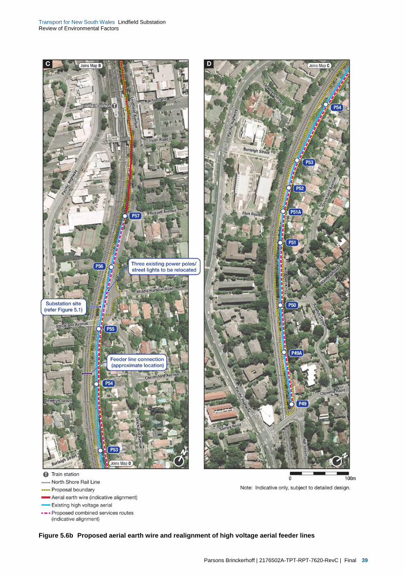
Parsons Brinckerhoff | 2176502A-TPT-RPT-7620-RevC | Final 39
Transport for New South Wales Lindfield Substation Review of Environmental Factors
Figure 5.6b Proposed aerial earth wire and realignment of high voltage aerial feeder lines

40 Parsons Brinckerhoff | 2176502A-TPT-RPT-7620-RevC | Final
Transport for New South Wales Lindfield Substation Review of Environmental Factors
5.2.4 Aerial earth wire
In addition to the relocation of the existing aerial 33kV and 11 kV feeder lines, a new aerial earth wire would
be required to be installed between Killara Station in the north and existing power pole P57 (near the
intersection with Russell Avenue) to the south. The installation of the aerial earth wire would be undertaken
through the placement of a new metal shaft to the top of the existing 33kV and 11kV power poles. The aerial
earth wire would then be attached to the new structure.
Where it is deemed that an existing power pole is in a poor condition, a new pole would be installed in a
similar location (within approximately one to two metres of the existing pole) and all existing wires relocated
to the new pole.
An example of a typical aerial earth wire arrangement to an existing power pole is shown in Figure 5.7.
Figure 5.7 Example of a typical aerial earth wire arrangement on the top of an existing power pole
Aerial earth wire
Example of an existing aerial earth wire attachment
33kV feeder line
11kV feeder line
Parsons Brinckerhoff | 2176502A-TPT-RPT-7620-RevC | Final 41
Transport for New South Wales Lindfield Substation Review of Environmental Factors
5.2.5 Utilities realignment
Notwithstanding the 33 kV and 11 kV aerial feeders that cross the substation site (refer to section 5.2.2), the
proposal would require some additional utility diversions. The utilities that may be impacted and may
therefore require augmentation as part of the proposed are discussed below.
Potential impacts to existing services and utilities would be confirmed during the detailed design phase of the
proposal, with any proposed relocation and/or protection works determined in consultation with the relevant
asset owners.
Ausgrid
Ausgrid high voltage underground cables are located in the footpath on the western side of Lindfield Avenue
adjacent to the substation site. Protection or adjustment of the cables at the vehicle access location may be
required if the depth of the Ausgrid services under the vehicle crossing does not meet Ausgrid requirements.
The Ausgrid low voltage overhead power lines in Lindfield Avenue adjacent to the substation site would also
require relocation to avoid clashes with cranes during construction and future maintenance operations.
Three poles would be removed and replaced with underground conduits located in the roadway.
The Ausgrid street lighting supply aerial cable in Lindfield Avenue would be relocated to the eastern side of
Lindfield Avenue. The location of the new street lighting would be revised during detailed design to maintain
appropriate lighting levels.
Telstra
There is a major Telstra route with 20 conduits in the footpath on the western side of Lindfield Avenue
adjacent to the substation site. Several Telstra access chambers are also located in the footway adjacent to
the substation site, and vehicular crossing locations have been located to avoid these access chambers.
Protection or adjustment of the conduits at the vehicle access location may be required if the depth of the
Telstra services under the vehicle crossing does not meet Telstra requirements.
Foxtel/Telstra cables have also been identified as aerial cables on the Ausgrid poles which are to be
removed. These cables would be relocated as part of the overall relocation of cabling from these poles.
Optus
Optus aerial cables are mounted on the Ausgrid poles which are required to be removed. These cables
would be relocated as part of the overall relocation of cabling from these poles.
Jemena (Gas)
A Jemena 110 millimetre diameter nylon gas main crosses the rail alignment on the southern side of the
Strickland Avenue overbridge and then crosses to the eastern side of Lindfield Avenue. It is not expected
that the proposed works would impact this gas main.

42 Parsons Brinckerhoff | 2176502A-TPT-RPT-7620-RevC | Final
Transport for New South Wales Lindfield Substation Review of Environmental Factors
5.2.6 Substation equipment
The substation would contain primary (rectifier transformers, rectifiers, reactors) and secondary (switchgear
and switchboards, batteries and changers, voice and data communications) equipment which would be
installed within the new building structure.
Equipment and facilities within the proposed substation building would include:
two x Rectifier Transformers and associated rectifier/switchgear
two x auxiliary transformers
one x 11kV and 2 x 33kV switchboards
one x reactor and main negative bar
one x 1,500V DC isolating and rail connecting switches (IRCSs) bank
supervisory control and data acquisition (SCADA), remote terminal unit (RTU) and marshalling panel
telecommunication equipment
battery bank and charger(s)
small office area with washroom amenities.
The final design and specifications of the proposed equipment to be installed within the substation would be
refined during the detailed design phase of the proposal to meet the specific ongoing requirements of the
Sydney Trains network at the time of construction.
Cabling
All cables would be installed to allow adequate space for fixing and for heat dissipation. Control and
induction cables and light and power cables would be run separately from the high voltage cables in
accordance with installation standards. High voltage cables would be insulation tested to ensure their
integrity prior to connection to equipment. The final testing and connection to the Sydney Trains network
would be carried out during track possessions and high voltage electrical isolations of the North Shore Line.
Traction supply feeders and return cables also would be installed as part of the construction of the
substation.
5.3 General construction approach
Minor enabling works are expected to be undertaken in late 2014. Service relocation will commence in mid-
2015 with construction of the substation expected to commence in early 2016 (subject to Transport for
NSW’s determination of this REF) with testing and commissioning anticipated in August 2017.
The substation site is expected to be handed over to Sydney Trains in late 2017.
The methodology presented below is based on the current concept design and will be subject to confirmation
by the construction contractor (not yet appointed). Any material changes to the construction methodology
which could result in additional environmental impacts to those assessed in this REF would be the subject of
additional environmental assessment or consistency review.

Parsons Brinckerhoff | 2176502A-TPT-RPT-7620-RevC | Final 43
Transport for New South Wales Lindfield Substation Review of Environmental Factors
It is anticipated that the main construction activities would generally be carried out in the following sequence:
establishment works and vegetation clearance
excavation
civil and building works including:
access improvements
piling works and deflection/retaining wall
drainage works
cable sub-floor chamber
ground beams
floor slab
super structure
electrical fit out
pre-commissioning and commissioning.
Site establishment and vegetation clearance
On possession of the proposal site, the contractor will initially install any additional temporary fencing to
adequately secure the site (in particular the substation site), and install all necessary construction
environmental management measures such as sedimentation controls (refer section 7.2.1). Following this,
the proposal site would be rechecked for all utility services and any affected services will be relocated or
made safe to allow construction to proceed.
Minor earthworks will be undertaken to establish the site amenities. These earthworks would include:
cut and fill to establish a level area for the site facilities and temporary storage areas
trenching to install services (power, water, sewer)
refurbishment of existing proposal site access and access roads.
The site for the substation and southern half of the electrical works site would then be cleared of existing
vegetation and grubbed, and access roads would be constructed to the area for the substation site facilities
and temporary storage areas (where required).
As part of the initial preparation works for the new traction power feeder lines and improvement to the rail
corridor access from Strickland Lane, clearance of some vegetation would also be undertaken generally to
the south of the Strickland Road overbridge. Further discussion regarding the proposed vegetation clearance
is provided in section 6.4 of this REF.
Site office(s) and any other temporary buildings would also be brought onto site at this time, with power
connected to these buildings. Construction power supplies for the site facilities and construction activities
would be sourced from local Ausgrid street supplies. Construction water supply would be sourced from the
existing Sydney Water street supplies in Lindfield Avenue. Provision would be made to utilise this connection
for the permanent water supply to the completed substation.
Construction hoardings and/or temporary acoustic fencing/barriers would be erected around the substation
site perimeter and southern half of the electrical works site where this is considered to be feasible and
reasonable to mitigate off-site noise levels. Noise barriers would be effective for receptors at or near ground
level and not effective for receptors overlooking the sites. If required, large hoardings may require significant
footings.

44 Parsons Brinckerhoff | 2176502A-TPT-RPT-7620-RevC | Final
Transport for New South Wales Lindfield Substation Review of Environmental Factors
As part of site establishment, the existing cess area (a track drainage area adjacent to the railway tracks)
between the OHW stanchions and the existing rock face on the up-track side of the North Shore Line would
be cleared and safety barriers (New Jersey barriers with an extended three metre grid fence above) would
be installed to protect the track and site during the piling, retaining wall and excavation works.
Combined services routes
The North Shore Line CSR would run through the substation site and would be relocated to allow
construction of the substation. The CSR currently contains a mix of signalling and communications cables.
A new trunk CSR would be constructed using a mix of buried pit and conduit and above ground GST and
would service relocated signals, communications and 11kV and 33kV feeder lines. The new route would run
from power pole P57 along the embankment in GST then underground in pit and conduit adjacent to the new
vehicle access and back to a temporary mounting along the length of the substation. South of the Strickland
Road bridge the cabling would re-join the existing CSR.
The new CSR south of the Strickland Road bridge would be constructed using a mix of buried conduit and
GST between the Strickland Avenue and power pole P49 for sole use of the 11kV and 33kV feeders
(refer below). Following completion of the substation works, a permanent CSR will be constructed on the
trackside face of the substation basement wall.
Signalling and communications
The relocation would be carried out in two phases. Phase 1 would include construction of a new pit and pipe
CSR from a pit adjacent to power pole P56 (part of the northern section of the electrical works site) under the
maintenance access road to trackside. A temporary CSR would be attached to the New Jersey barriers as
far as the up-track side of the Strickland Avenue road bridge and then by a new pit and pipe CSR re-joining
the existing CSR at a pit adjacent to power pole P55 (about 10 metres to the south of the Strickland Avenue
road bridge).
Signalling and communications cables would be cut at suitable locations either side of the new route and
new cabling pulled through the new CSR, spliced to existing cables and tested. Any cable that cannot be
spliced for operational or technical reasons would be replaced and terminated at its original point.
Relocation of these cables would be carried out during a North Shore railway line track possession period.
Phase 2 would take place following completion of substation piling and construction of the retaining wall.
A permanent CSR consisting of GST would be mounted on the trackside face of the retaining wall and the
signalling and communications cable lifted from the temporary CSR and placed in the GST.
High voltage aerial realignment
Realignment of the aerial feeders would commence during completion of the substation basement and the
trackside retaining wall and concurrent with completion of the substation civil and building works.
All realignment works would be carried out during North Shore Line track possession period(s) and high
voltage electrical possession(s).
Construction of the underground and GST routes would be completed between existing power poles P57
and P49 (refer to section 5.2.2). The 33 kV and 11 kV cable would be installed ready for connection to the
underground overheads (UGOH’s). Sufficient additional length of cables would be provided between the
UGOH’s poles to allow cutting and pulling of the 33 kV and 11 kV cables into the proposed substation when
equipment installation has been completed and the proposed substation is available for connection to the
respective power supplies.

Parsons Brinckerhoff | 2176502A-TPT-RPT-7620-RevC | Final 45
Transport for New South Wales Lindfield Substation Review of Environmental Factors
Piling and retaining wall works
Retaining walls for the substation site would be constructed within the embankment. This may involve the
use of piling rigs to construct the retaining walls required to hold back the existing rail embankment.
This would be required to be undertaken during a track possession period (refer to section 5.3.3 for further
details).
Excavation
Excavation would be undertaken to remove excess material from the substation site and level the site.
Some spoil from the excavation may be reused on site for filling and compaction of the facilities/storage
areas and access improvements for the existing access which is currently gained off Strickland Lane.
Excavation works will be carried out using diesel powered excavators and rockbreakers and excess spoil
would be removed from site by dump truck for off-site disposal, in accordance with a Construction Traffic
Management Plan for the proposed works (refer to section 6.1).
Based on the current substation layout, the estimated earthworks volume for the Lindfield substation is
approximately 4,500 cubic metres. This is the in-situ volume of the material to be excavated with no
allowance for bulking. Where possible, spoil generated would be used within the wider proposal site to
provide the required levels. However, spoil that cannot be used would be sent for recycling or disposal to a
licensed facility.
There would also be a requirement to maintain safe working clearances under the 33 kV and 11 kV aerial
feeders within the substation site. Accordingly, excavation of the substation site would commence at the
northern end, where clearances from natural ground level to the aerials exceed the safe working
requirements. Benching and spoil removal would progress to the south of the substation site using rock
breakers, excavators and trucks. This methodology would ensure that safe clearances are maintained and
excavation works can proceed without the requirements for electrical possessions of the North Shore Line.
Civil and building works
Civil works
The civil works would commence with construction of the foundation works following excavation and
drainage works for the foundation, installation of the earthgrid and then formation and casting of reinforced
concrete sections from the basement level to the final substation equipment floor level. Works adjacent to the
North Shore Line would be undertaken in accordance with rail safe working requirements due to the close
proximity of the up-track.
Some works may need to be carried out during the weekend track possessions (rail close-downs) of this line.
Building works
Building works, including interior and exterior walls and roofing, would be progressed to lock-up stage ready
for building services installation including general lighting, power, ventilation and hydraulic services.
Installation of electrical equipment for the substation would be undertaken using cranes to lift in the required
equipment.
Large and/or heavy equipment would be craned into position which may require a temporary closure of
Lindfield Avenue during lifting operations.

46 Parsons Brinckerhoff | 2176502A-TPT-RPT-7620-RevC | Final
Transport for New South Wales Lindfield Substation Review of Environmental Factors
Pre-commissioning activities
Pre-commissioning activities would form part of the construction and installation works and would incorporate
all tests and checks to confirm that construction quality assurance documentation, inspection and test plans,
checklists and associated activities have been completed for each individual component of plant. This is to
ensure that it has been supplied and installed in accordance with the design and statutory standards and is
safe to proceed to commissioning.
Site clean-up and landscaping
This phase would occur following the completion of construction and involve the removal of all materials not
required during the operation of the substation. This would primarily be the removal of the construction
compound.
New landscaping would also be provided around the perimeter of the substation site following the completion
of the main building works to assist with screening of the new substation structure (refer to Figure 5.4 and
Figure 5.5 for an indicative illustration of the proposed landscaping).
5.3.1 Construction plant and equipment
An indicative list of construction plant and equipment likely to be required for the key construction elements is
provided below. Not all of the equipment identified below would be required for all phases of the proposed
construction of the Lindfield substation and electrical works.
Bobcat
Bulldozers
Cable trucks
Cable winch
Chainsaws
Compressors
Concrete trucks
Coring equipment
Cranes
Delivery vehicles
Elevated work platforms
Excavators with rock breaker
Flat top trucks
Front end loaders
Generators
Hi-rail trucks with Hiab cranes
Jack hammers
Jointing and welding equipment
Lighting
Miscellaneous small tools
Mobile concrete pump
Personnel vehicles
Piling rig
Rollers/compactor
Scrapers
Small vehicles
Traffic control vehicles
Trucks
Truck mounted augers
Water truck

Parsons Brinckerhoff | 2176502A-TPT-RPT-7620-RevC | Final 47
Transport for New South Wales Lindfield Substation Review of Environmental Factors
5.3.2 Workforce and working hours
A total of approximately 20 to 30 construction staff would be required on-site for the duration of the
construction period however the number of personnel may increase and vary depending on the type of work
being undertaken in accordance with the work methodology.
Works would be generally undertaken within the standard EPA construction hours, which are as follows:
7.00 am to 6.00 pm Monday to Friday
8.00 am to 1.00 pm Saturdays
no work on Sundays or public holidays.
Out-of-hours works
Some work will be required outside of standard construction hours and would be mainly during rail
possessions. In addition, there may be occasions when oversized deliveries of materials or substation
electrical equipment may need to occur outside of peak traffic hours, standard construction hours or during
rail possessions.
Exemptions and approval for works outside the above standard construction hours may also be required in
the following circumstances:
works required by utility service providers or where impacts to services cannot be reasonably managed
works requiring track possessions (as outlined below)
unloading of machinery that can only be transported between hours specified by the police or Roads
and Maritime
where works can be undertaken so as to be inaudible at the nearest residential receivers
as otherwise agreed with the EPA in the issuing of an environmental protection licence for licensable
works.
If required, out-of-hours works would be applied for by the construction contractor and appropriate
assessments, mitigation strategies undertaken prior to these works being undertaken. Nearby residents,
businesses and stakeholders would be notified in advance.
Rail possession works
Rail possessions are times when rail services are not running, allowing maintenance and/or construction
works to be safely undertaken. Sydney Trains is permitted a certain number of weekend rail possessions per
year to allow for railway maintenance, construction and other activities that are only able to be undertaken
whilst normal services are not operating.
5.3.3 Traffic management and construction access
A majority of construction traffic would enter the proposal site from the Pacific Highway into Strickland
Avenue and turn left into Lindfield Avenue. This route avoids the Balfour Street underpass and the shopping
precinct in Lindfield Avenue. The proposal site would typically be exited via Lindfield and Strickland Avenues
back to the Pacific Highway. This route is suitable for all construction materials including concrete and
manufactured items, such as transformers, switchboards and other electrical equipment.

48 Parsons Brinckerhoff | 2176502A-TPT-RPT-7620-RevC | Final
Transport for New South Wales Lindfield Substation Review of Environmental Factors
Construction access will be provided from the following locations:
Lindfield Avenue — Access to and egress from the substation site would be via Lindfield Avenue which
is subject to a local area three-tonne load limit. A temporary closure of Lindfield Avenue would be
required for the delivery and installation of major heavy equipment such as substation transformers and
rectifiers.
Strickland Avenue — Construction traffic would exit the Pacific Highway via Strickland Avenue, which
also has a local area three-tonne load limit, and turn left into Lindfield Avenue. Construction traffic
leaving the substation site would travel via Lindfield Avenue and turn right into Strickland Avenue and
then to the Pacific Highway.
Strickland Lane — Construction traffic would exit the Pacific Highway via Strickland Avenue, which also
has a local area three-tonne load limit, and turn right into Strickland Avenue and progress through local
streets to Strickland Lane. Strickland Lane provides a vehicle route between Strickland Avenue and the
rail access gate.
Clanville Road — Construction traffic would exit the Pacific Highway via Clanville Road. Construction
traffic leaving the southern portion of the electrical works site would travel via Clanville Road and then to
the Pacific Highway. A Traffic Management Plan would be prepared in consultation with Ku-ring-gai
Council. Any disturbed surface will be reinstated to match pre-existing conditions.
Further details regarding access and haulage routes for the proposal are provided in section 6.1.2.
5.3.4 Potential site compounds and storage
There is minimal space available within the existing rail corridor for site compounds and materials storage.
Worksites would be established within suitable barriers and protected by traffic management establishment
in accordance with the approved Traffic Management Plan.
If required small site compound(s) could be positioned within the rail corridor to the north of the substation
site (subject to discussion with Sydney Trains). It is expected that contractors would operate from their local
depots with materials and equipment loaded on trucks and brought to site for immediate installation, where
possible. Temporary fencing would be provided to the site during construction for public safety and site
security.
5.4 Operation and maintenance
5.4.1 Commissioning
This phase of works would link the substation construction activities to the operational activities. Once all
high voltage and low voltage testing is completed, electrical protection systems have been set and all
Quality Assurance documentation has been completed and the systems energised, commissioning would
proceed.
The new substation would be commissioned and integrated with any necessary Sydney Trains external
facilities.

Parsons Brinckerhoff | 2176502A-TPT-RPT-7620-RevC | Final 49
Transport for New South Wales Lindfield Substation Review of Environmental Factors
5.4.2 Operational access
Once commissioned, access to the site would be via Lindfield Avenue at the new driveway entry, as shown
on Figure 5.6. The existing maintenance access into the rail corridor would be relocated to the northern side
of the new substation, subject to consultation with Sydney Trains.
5.4.3 Ongoing maintenance of the substation and feeder lines
Once construction is completed, the Lindfield substation would undergo testing and would be commissioned
for service. Once operational, the maintenance requirements of the substation and traction power feeder
lines are anticipated to be small. For the substation building, it is anticipated that there would be up to one
site visit per month by one person for maintenance and attendance for switching operations during power
isolations.
Overhead traction power feeder lines would be inspected in accordance with Sydney Trains operational
requirements.


Parsons Brinckerhoff | 2176502A-TPT-RPT-7620-RevC | Final 51
Transport for New South Wales Lindfield Substation Review of Environmental Factors
6. Environmental impact assessment
This chapter provides an environmental impact assessment for the proposed construction and operation of
the proposed traction power substation and associated electrical works in Lindfield (‘the proposal’).
6.1 Traffic and transport
A traffic and transport assessment has been prepared by Parsons Brinckerhoff and is included as
Technical Paper 1. A summary of the assessment is provided in the following sections.
6.1.1 Existing traffic and transport environment
Road network and hierarchy
Roads within a network are classified according to a road hierarchy relating closely to their functional role
and the volume of traffic they carry. Roads and Maritime has defined four classes for the classification of
roads:
arterial roads
sub-arterial roads
collector roads
local roads.
The key roads on the surrounding road network include:
Pacific Highway (A1) — a six-lane undivided road configuration which carries approximately
58,000 vehicles per day (refer Technical Paper 1) through the Chatswood area. As a major arterial road,
this road is designated as a B-double route and allows vehicles with a maximum vertical height
clearance of 4.6 metres.
Lindfield Avenue — a two-lane, two-way collector road that provides an important link on the eastern
side of the Pacific Highway and railway line connecting the Lindfield town centre to local residents.
Lindfield Avenue has a posted speed limit of 50 kilometres per hour.
Strickland Avenue — a two-lane, two-way local road that provides an important link on the eastern side
of the Pacific Highway and railway line connecting the Lindfield town centre to local residents, and
providing a key local railway crossing (bridge). Strickland Avenue has a posted speed limit of
50 kilometres per hour.
Clanville Road — a is a two-lane, two-way local road that provides an important link on the northern
side of the Pacific Highway connecting to local residents to the Pacific Highway via a key local railway
crossing (bridge). Clanville Road has a posted speed limit of 50 kilometres per hour.
Unrestricted on-street parallel parking is currently provided on both sides of Lindfield Avenue adjacent to the
substation site. Pedestrian footpaths are located on both sides of Lindfield Avenue adjacent to the substation
site.

52 Parsons Brinckerhoff | 2176502A-TPT-RPT-7620-RevC | Final
Transport for New South Wales Lindfield Substation Review of Environmental Factors
Vehicle load, length, height and turning restrictions
A review of the Roads and Maritime Restricted Access Vehicle information and details obtained during a site
inspection indicate the following restrictions apply to certain vehicles in the study area:
three tonne load limit on Strickland Avenue, Lindfield Avenue and Rawhiti Street, Lindfield near the
wider proposal site
four metre height clearance on Balfour Street, Lindfield (road under railway bridge).
Rail services
Existing access to the North Shore Line rail corridor is currently provided through the future substation site
via a gated access off Lindfield Avenue. This existing access will be relocated further north along Lindfield
Avenue (north of Middle Harbour Road – refer to section 6.1.4 below), subject to discussion with Sydney
Trains.
Additional access gates would be utilised from Clanville Road, Strickland Lane and Llewellyn Street.
These access locations would not require relocation as part of the proposal.
Bus services
Bus services that currently operate in the Lindfield area are provided by Transdev and include a service
along Lindfield Avenue and Middle Harbour Road.
Parking
Within the vicinity of the main substation site, unrestricted on-street parallel parking is currently provided on
Lindfield Avenue, Strickland Avenue and Middle Harbour Road in close proximity of the substation site.
No on-street parallel parking is provided at the cable and service relocation accesses on Llewellyn Lane,
Strickland Lane and off Clanville Road. On-street parallel parking is however provided on both sides of
Llewellyn Street and Burleigh Street which adjoin Llewellyn Lane.
6.1.2 Traffic and transport impacts during construction
The potential impacts of construction traffic on the existing traffic and transport environment are described
below.
Construction traffic generation and distribution
Traffic generation during construction of the project is assumed to comprise traffic generated by construction
personnel and construction vehicles travelling to and from the proposal site. During construction, traffic
movements would vary depending on the stage of works being completed. However, most movements would
occur during the earthworks and civil construction phases. The anticipated typical construction traffic
generated by this project is presented in Table 6.1. Construction staff are assumed to arrive at the proposal
site by personal vehicle.
Table 6.1 Construction traffic generation
Location/Construction elements
Number of workforce
(daytime shift)
Trips during the PM peak hour
Total daily trips during weekend day
(in and out)
Construction of substation Up to 20 10 40
Cable and services relocation works Up to 10 5 20

Parsons Brinckerhoff | 2176502A-TPT-RPT-7620-RevC | Final 53
Transport for New South Wales Lindfield Substation Review of Environmental Factors
Construction staff would generally arrive at the proposal site before the shift start at 7.00 am and would
generally depart the site after the shift between 3.00 pm and 6.00 pm. The construction light vehicle trips
were not considered for the morning peak hour traffic assessment as they do not coincide with the
background morning traffic peak. However they were considered for the afternoon peak hour traffic
assessment as they would coincide with the background afternoon traffic peak. It is assumed approximately
50 per cent of construction light vehicle outbound trips would occur during the afternoon peak hour.
Construction vehicle trips (heavy vehicles) were considered for the assessment during both the morning and
afternoon peaks as they would occur throughout the working day (shift).
The proposed construction traffic would generate a minor impact to existing local traffic conditions due to an
increase in construction traffic comprising typically vehicles transporting equipment, materials and spoil;
mobile cranes for use in work sites; and worker vehicles.
Transport for NSW and/or the contractor would notify the community of any proposed traffic and pedestrian
changes prior to construction and during the construction process. Access to surrounding properties would
be maintained throughout construction and operation of the proposal.
Two-way traffic would generally be maintained on local roads at all times during construction of the project.
Temporary closure of Lindfield Avenue would however be required for the delivery and installation of
substation transformers. Ku-Ring-Gai Council and Roads and Maritime (as appropriate) would also be
notified of any proposed road impacts and would be provided with an appropriate construction traffic
management plan (CTMP) for these impacts. Transport for NSW would obtain all appropriate ‘road opening’
and ‘control of traffic at work sites’ licences, and approvals that may be required for the proposal (subject to
detailed design and final construction methodology).
Access and haulage routes
Construction traffic would primarily access the site via the Pacific Highway, Strickland Avenue and then into
Lindfield Avenue. Construction vehicles would access the site via the proposed new entrance gate along
Lindfield Avenue (refer to Figure 6.1a and Figure 6.1b). Additional access for the cable and service
relocation would occur from existing Sydney Train access gates in Llewellyn Lane, Strickland Lane and
Clanville Road (refer to Figure 6.1a and Figure 6.1b). Lindfield Avenue is subject to a local area three tonne
load limit (refer to section 6.1.1).
Construction traffic would enter the substation site from the Pacific Highway into Strickland Avenue and turn
left into Lindfield Avenue, refer to Figure 6.1a and Figure 6.1b. This route avoids the Balfour Street
underpass and the shopping precinct in Lindfield Avenue. This route is suitable for all construction materials
including concrete and manufactured items, such as transformers, switchboards and other electrical
equipment. Access to the proposal site would also require the temporary removal of approximately six on-
street parking spaces during construction to allow vehicle site access. Additional access gates would be
utilised from Clanville Road, Strickland Lane and Llewellyn Street (refer to Figure 6.1b). These access gates
would generally be used to access the rail corridor south of the Strickland Road bridge for the construction of
the proposed CSR works (for the existing 11kV and 33kV feeder cable relocations).
A permit to exceed the local load limit would be obtained from Ku-Ring-Gai Council on an as required basis
for delivery of construction equipment, removal of excess spoil from substation site excavation activities,
concrete deliveries and delivery of construction materials and equipment. Temporary closure of
Lindfield Avenue would also be required for the delivery and installation of substation transformers. A CTMP
would be prepared in consultation with Ku-Ring-Gai Council. Any disturbed surface would be reinstated to
match pre-existing conditions. The substation worksite would be established within suitable barriers and
protected by traffic management establishment in accordance with the approved CTMP.

54 Parsons Brinckerhoff | 2176502A-TPT-RPT-7620-RevC | Final
Transport for New South Wales Lindfield Substation Review of Environmental Factors
Figure 6.1a Proposed access and heavy vehicle haulage route to the proposal site

Parsons Brinckerhoff | 2176502A-TPT-RPT-7620-RevC | Final 55
Transport for New South Wales Lindfield Substation Review of Environmental Factors
Figure 6.1b Proposed access and heavy vehicle haulage route to the proposal site

56 Parsons Brinckerhoff | 2176502A-TPT-RPT-7620-RevC | Final
Transport for New South Wales Lindfield Substation Review of Environmental Factors
Intersection performance
At the proposal site, up to 10 vehicles (refer to Table 6.1 above) could be leaving in the afternoon peak hour.
These vehicles are likely to travel to the Pacific Highway via either Balfour Street or the adjacent intersection
at Strickland Avenue. The Strickland Avenue intersection is unsignalised and, therefore, the impacts would
be minimal. The low vehicle volumes would also result in minimal impacts at the Balfour Street intersection.
Construction vehicle and staff parking
Construction vehicles would be parked off-street within the rail corridor. Where possible, personal
construction staff vehicles would be parked off-street as well, however there would be limited or no space for
construction staff vehicle parking at the substation site. It is considered that the surrounding streets within the
local area have sufficient capacity to allow for the temporary use of some parking spaces for this use during
construction.
Pedestrians and cyclists
Given the location of the proposal site and location of all works within the existing rail corridor, there are not
expected to be any impacts to pedestrians or cyclists at any of the proposed worksites or stations.
However, temporary pedestrian footpath diversions within the vicinity of the proposal site are likely to be
required during construction. Pedestrians would generally be diverted to the existing pedestrian footpaths on
the adjacent side of Strickland Avenue and Lindfield Avenue during the construction period. Appropriate
directional signage would be erected.
Property access
There are not expected to be any impacts to existing property accesses along Lindfield Avenue.
6.1.3 Traffic and transport operational impacts
Once construction is completed, the Lindfield substation would undergo testing and would be commissioned
for service. Traffic and transport operational impacts of the proposed Lindfield substation are expected to be
minimal. Only one vehicle per month is anticipated to be required at the substation site to undertake
maintenance at the site.
The relocation of the existing rail corridor access gate to the northern end of the proposed substation site
may result in the loss of approximately two existing on-street, parallel parking spaces along Lindfield Avenue.
Once construction is completed, maintenance requirements of the relocated HV cables and other services
are anticipated to be small and have only negligible traffic impacts on the surrounding road network and local
intersections.
6.1.4 Management and mitigation measures
As part of the Construction Environmental Management Plan (CEMP), a Construction Traffic Management
Plan (CTMP) would be developed to address construction traffic and transport management. The following
management and mitigation measures would be implemented as part of the CTMP to minimise the traffic and
transport impacts of the proposal:
traffic controllers positioned at access gates adjacent to residential areas and access driveways
road occupancy licences for temporary closure of roads would be obtained, where required
heavy vehicles would be restricted to the routes specified and route markers installed for heavy vehicles
along designated routes

Parsons Brinckerhoff | 2176502A-TPT-RPT-7620-RevC | Final 57
Transport for New South Wales Lindfield Substation Review of Environmental Factors
signs would be provided at the site access point to assist in deliveries to the worksite
signs would be provided at the access point for pedestrian and cyclist guidance
traffic controllers would be located at the access point to direct vehicle movements, vehicle deliveries,
pedestrians and cyclists, where required
an emergency response plan would be developed for construction traffic incidents
a pre and post-construction assessment of road pavement assets would be conducted in areas likely to
be used by construction traffic
public communications would be conducted to notify the community and local residents of vehicle
movements and anticipated effects on the local road network relating to the site works
access to all private properties adjacent to the works would be maintained during construction
during project inductions, all heavy vehicle drivers would be provided with the emergency response plan
for construction traffic incidents
road safety audits would be undertaken where required or deemed necessary
project staging, vehicle movement and scheduling, equipment and resourcing would be coordinated.
Given the minimal traffic impacts during operation, no specific mitigation measures are proposed for
operation.
6.2 Noise and vibration
A Noise and Vibration Assessment addressing both construction and operational noise and vibration for the
proposed substation was undertaken by SLR Consulting Australia Pty Ltd in March 2014 (refer to Technical
Paper 2). The results of this assessment are summarised below.
6.2.1 Methodology
To quantify and characterise the existing ambient noise environment adjacent to the proposed works,
baseline noise surveys were undertaken. At the proposed substation site, an unattended survey was
undertaken from 11 to 18 December 2013. The measured noise levels were then applied to establish
appropriate noise assessment goals for fixed facilities and as a basis for assessing potential noise impacts
during construction.
Methodology for unattended noise monitoring
Unattended noise monitoring of the substation site was undertaken using a noise logger which continuously
measured noise levels in 15 minute sampling periods to determine the existing LAeq, LA90 and other relevant
statistical noise levels during the daytime, evening and night-time periods.
The noise measurements were carried out with a typical Acoustic Research Laboratories Environmental
Noise Logger. The equipment was set up with a microphone at approximately 1.5 metres above the ground
level and, where possible, at least one metre from the facade of the subject building.
The noise measurements were carried out with typical Acoustic Research Laboratories Environmental Noise
Loggers. The calibration of the noise logger was checked both before and after each measurement survey
and the variation in calibration at the site location was found to be within acceptable limits at all times.
The analysis of the measured noise levels was been carried out in accordance with the procedures
contained in the NSW Industrial Noise Policy (INP) (EPA, 2000) to establish representative noise levels.
Consistent with the INP, periods of unsatisfactory monitoring conditions of rain and wind speeds greater than
five metres per second were filtered from the results.

58 Parsons Brinckerhoff | 2176502A-TPT-RPT-7620-RevC | Final
Transport for New South Wales Lindfield Substation Review of Environmental Factors
Attended airborne noise measurements
Attended measurement of ambient noise was also used to determine the various noise sources that
influence the existing noise environment at the substation site. During the measurement, the observer noted
the various noise sources and the contributing noise level.
The attended measurements were performed using a Brüel and Kjaer Type 2260 sound level meter for a
minimum period 15 minutes. The wind speed was less than five metres per second at all times, and the
measurements were performed at a height of 1.5 metres above ground level. Calibration of the sound level
meter was checked before and after the measurement and the variation in calibration was found to be within
acceptable limits at all times.
6.2.2 Existing noise environment
Receiver locations
As described in section 6.5 of this REF, the predominant surrounding land uses are a combination of low
density and medium density residential uses. The sensitive noise receptors are generally located
surrounding the substation site on both the eastern side of Lindfield Avenue and the western side of the
North Shore Line. During a site inspection, the nearest affected residential receivers were identified.
The identified sensitive residential receiver properties within the vicinity of the substation site are shown on
Figure 6.2 whilst the approximate distance to each of the receivers is shown in Table 6.2.
Table 6.2 Sensitive Receivers near the substation site
Receiver Address Approximate distance to site (metres)
R1 239 Pacific Highway, Lindfield 25
R2 251 Pacific Highway, Lindfield 25
R3 4 Middle Harbour Road, Lindfield 25
R4 1 Middle Harbour Road, Lindfield 25
R5 36 Strickland Avenue, Lindfield 30
Existing background and ambient noise levels
Unattended noise monitoring results
The results of the unattended ambient noise survey are presented in Table 6.3. The rating background level
(RBL) refers to the single overall background noise level measured in each relevant assessment period
(day, evening or night), while LAeq refers to the average noise level evaluated over the daytime, evening and
night-time periods and is used to assess the potential construction noise impacts.
Table 6.3 Summary of unattended noise logging
Location Address
Noise level (dBA)1
Daytime
7.00 am to 6.00 pm
Evening
6.00 pm to 10.00 pm
Night-time
10.00 pm to 7.00 am
RBL LAeq RBL LAeq RBL LAeq
BG1 – Lindfield In rail corridor near access gate
48 59 44 58 33 53
Note 1: The RBL and LAeq noise levels have been obtained using the calculation procedures documented in the INP.

Parsons Brinckerhoff | 2176502A-TPT-RPT-7620-RevC | Final 59
Transport for New South Wales Lindfield Substation Review of Environmental Factors
Attended airborne noise measurements
The noise environment at the attended monitoring location is described in Table 6.4.
Table 6.4 Summary of attended noise monitoring results
Location Noise level (dBA)
Description and typical LAmax Levels (dBA)
LAmax LA1 LA10 LAeq LA90
BG1 – Lindfield
18/12/13
75 70 66 58 51 60–64 cars
55 birds
70 motorbike
66 train
LAmax: The ‘typical maximum noise level’ for an event, used in the assessment of potential sleep disturbance during night-time periods.
LAeq(15minute): The ‘energy average noise level’ evaluated over a 15 minute period
LA90: The ‘background noise level’ or Rating Background Level (RBL) in the absence of construction activities. This parameter represents the average minimum noise level during the daytime, evening and night-time periods respectively and is used to set the LAeq(15minute) noise management levels for residential receivers.
Figure 6.2 Noise monitoring location and sensitive receivers adjacent to the proposed substation site

60 Parsons Brinckerhoff | 2176502A-TPT-RPT-7620-RevC | Final
Transport for New South Wales Lindfield Substation Review of Environmental Factors
6.2.3 Noise and vibration guidelines
Construction noise and vibration strategy
A Construction Noise and Vibration Strategy (CNVS) would be required to be adopted by contractors to
manage construction noise and vibration as part of the construction of the Lindfield substation (refer to
Appendix C of Technical Paper 2). In preparing this strategy, consideration was given to several guideline
documents including the Interim Construction Noise Guideline (DECC 2009), Transport for NSW’s
Construction Noise Strategy, Australian Standard AS 2436-2010 Guide to noise and vibration control on
construction, demolition and maintenance sites and the Road Noise Policy (DECCW 2011).
The CNVS documents the best-practice techniques for managing construction noise and vibration, and
implementing feasible and reasonable mitigation measures. The CNVS includes a standard suite of
mitigation measures to be implemented across construction sites (such as periodic notification of proposed
works, adherence to construction respite periods, use of non-tonal reversing alarms, etc.). It also includes
additional mitigation and management measures when construction noise is predicted to exceed the noise
management levels (such as noise monitoring, individual briefings, respite offers and in some instances at
night, alternative accommodation). These measures are primarily aimed at proactive engagement with
affected sensitive receivers.
In addition to the mitigation measures described in the CNVS, contractors may introduce further measures or
mitigation strategies to reduce noise and vibration impacts at sensitive receivers. The CNVS is provided in
Appendix C of the Noise and Vibration Technical Paper (Technical Paper 2 of this REF).
Construction noise criteria
Noise management levels
The Interim Construction Noise Guideline (ICNG) (DECC, 2009) sets out ways to deal with the impacts of
construction noise on residences and other sensitive land uses. It does this by presenting assessment
approaches that are tailored to the scale of construction projects. The ICNG contains a quantitative
assessment method which is applicable to new infrastructure projects. Guidance levels are given for airborne
noise at residences and other sensitive land uses, including commercial and industrial premises. For
residences, guidance in relation to ground-borne noise and sleep disturbance is also provided.
The quantitative assessment method involves predicting noise levels at sensitive receivers and comparing
them with the guidance, or management levels. The ‘management levels’ are referred to as noise
management levels (NMLs). They have been reproduced from the ICNG and are presented in Table 4 of
Technical Paper 2. These NMLs apply to all the construction activities and sites associated with the
proposal. For residences, the NMLs are set with reference to the Rating Background Level or RBL.
Sleep disturbance and maximum noise level events
There are no specific criteria for sleep disturbance nominated in the ICNG, the INP and associated
Application Notes, or in the Road Noise Policy (RNP) (DECCW, 2011). Some guidance on possible impacts
is contained in the RNP which contains a section on sleep disturbance that includes a summary of current
literature.
The RNP concludes that:
maximum internal noise levels below 50 dBA to 55 dBA are unlikely to cause awakening reactions
one or two events per night, with maximum internal noise levels of 65 dBA to 70 dBA, are not likely to
affect health and wellbeing significantly.
Parsons Brinckerhoff | 2176502A-TPT-RPT-7620-RevC | Final 61
Transport for New South Wales Lindfield Substation Review of Environmental Factors
On the basis of the above guidance, i.e. an external sleep disturbance screening level of RBL + 15 dB, an
internal sleep disturbance NML of LAmax 55 dBA has been adopted, which equates to an external noise level
of 65 dBA (assuming open windows).
Construction vibration criteria
The effects of vibration in buildings can be divided into three main categories – those in which the occupants
or users of the building are concerned or possibly disturbed, those where the building contents may be
affected and those in which the integrity of the building or the structure itself may be prejudiced.
In relation to human comfort, the vibration management levels are based on guidance contained in the
Assessing Vibration – a technical guideline (DEC, 2006). Mitigation and management measures including
consideration of alternative construction methods, attended monitoring and observance of respite periods
are required in situations where vibration levels are predicted to exceed the management levels.
Structural damage vibration limits are based on Australian Standard AS 2187: Part 2-2006 Explosives –
Storage and Use – Part 2: Use of Explosives and British Standard BS 7385 Part 2-1993 Evaluation and
measurement for vibration in buildings Part 2. These standards provide frequency-dependent vibration limits
related to cosmetic damage, noting that cosmetic damage is very minor and superficial in nature, is readily
repairable and does not affect the structural integrity of the building.
In order to simplify the assessment process and provide a conservative assessment of the potential impacts
associated with the proposed construction activities, a conservative vibration damage screening level of
7.5 millimetres per second has been adopted for the proposal.
Operational Noise Criteria – Fixed facilities
Operational noise impacts have also been considered for the proposed substation. This type of plant is
considered to be fixed facilities and as such, operational noise levels are required to be assessed in
accordance with the INP.
The INP sets two separate noise criteria to meet environmental noise objectives – one to account for
intrusive noise and the other to protect the amenity of particular land uses. When determining project specific
noise criteria, both the amenity and intrusive criteria are considered. The more stringent of these two criteria
usually defines the project specific noise levels. For both amenity and intrusiveness, night-time criteria are
more stringent than daytime or evening criteria. As the substation has the potential to operate during any
period, the night-time period is likely to be the controlling time period.
To provide for protection against intrusive noise, the INP states that the LAeq noise level of the source,
measured over a period of 15 minutes, should not be more than 5 dB above the ambient (background)
LA90 noise level (or RBL), during the daytime, evening and night-time periods at the nearest sensitive
receivers. In this case, the RBLs listed in Table 6.4 describe the noise environment as measured near the
proposed fixed facilities.
To protect against impacts on amenity, the INP identifies recommended acceptable and maximum LAeq(period)
noise levels for particular land uses and activities during the daytime, evening and night-time periods. The
residences in the vicinity of the proposed facilities are considered to be ‘Suburban’. According to the INP, a
‘Suburban’ area would be characterised by local traffic with intermittent traffic flows, decreasing noise levels
in the evening period; and/or evening ambient noise levels defined by the natural environment and infrequent
human activity.
The amenity criteria for suburban residential receivers are shown in Table 6.5.
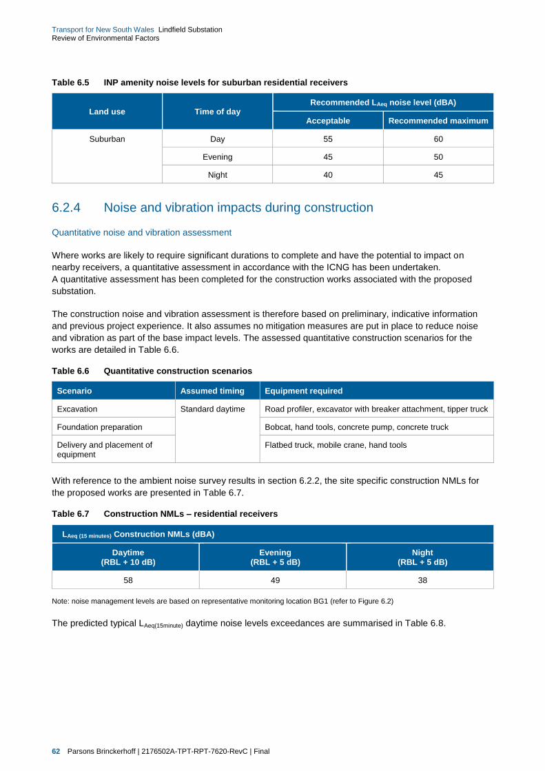
62 Parsons Brinckerhoff | 2176502A-TPT-RPT-7620-RevC | Final
Transport for New South Wales Lindfield Substation Review of Environmental Factors
Table 6.5 INP amenity noise levels for suburban residential receivers
Land use Time of day Recommended LAeq noise level (dBA)
Acceptable Recommended maximum
Suburban Day 55 60
Evening 45 50
Night 40 45
6.2.4 Noise and vibration impacts during construction
Quantitative noise and vibration assessment
Where works are likely to require significant durations to complete and have the potential to impact on
nearby receivers, a quantitative assessment in accordance with the ICNG has been undertaken.
A quantitative assessment has been completed for the construction works associated with the proposed
substation.
The construction noise and vibration assessment is therefore based on preliminary, indicative information
and previous project experience. It also assumes no mitigation measures are put in place to reduce noise
and vibration as part of the base impact levels. The assessed quantitative construction scenarios for the
works are detailed in Table 6.6.
Table 6.6 Quantitative construction scenarios
Scenario Assumed timing Equipment required
Excavation Standard daytime Road profiler, excavator with breaker attachment, tipper truck
Foundation preparation Bobcat, hand tools, concrete pump, concrete truck
Delivery and placement of equipment
Flatbed truck, mobile crane, hand tools
With reference to the ambient noise survey results in section 6.2.2, the site specific construction NMLs for
the proposed works are presented in Table 6.7.
Table 6.7 Construction NMLs – residential receivers
LAeq (15 minutes) Construction NMLs (dBA)
Daytime (RBL + 10 dB)
Evening (RBL + 5 dB)
Night (RBL + 5 dB)
58 49 38
Note: noise management levels are based on representative monitoring location BG1 (refer to Figure 6.2)
The predicted typical LAeq(15minute) daytime noise levels exceedances are summarised in Table 6.8.

Parsons Brinckerhoff | 2176502A-TPT-RPT-7620-RevC | Final 63
Transport for New South Wales Lindfield Substation Review of Environmental Factors
Table 6.8 Predicted daytime exceedences with no mitigation
Receiver area
Noise modelling scenario
Excavation Foundation preparation Delivery and placement
of equipment
R1 - 239 Pacific Highway, Lindfield
R2 - 251 Pacific Highway, Lindfield
R3 - 4 Middle Harbour Road, Lindfield
R4 - 1 Middle Harbour Road, Lindfield
R5 - 36 Strickland Avenue, Lindfield
Legend
Compliance
≤ 10 dB exceedance
10 dB to ≤ 20 dB exceedance
> 20 dB exceedance or LAeq(15minute) > 75 dBA
The findings of the construction noise impact assessment indicate:
the predicted daytime noise levels indicate high exceedances of the NMLs during excavation works at
nearest residences adjacent to substation site (properties R1 to R4 which have all been identified within
approximately 25 metres of the substation site). The predicted noise levels during this scenario are
anticipated to be greater than 75 dBA
during foundation preparation and delivery and placement of equipment, minor to medium exceedances
of the NMLs are anticipated.
It should be noted with respect to the proposed excavation, excavation within the rail corridor is expected to
take place over two weekend possessions during 2015. Further bulk excavation work for the substation
building would commence in early 2016 and is only anticipated to occur for approximately three months.
Construction vibration safe working distances
During site preparation and construction of the substation, the major potential sources of vibration emission
include rock breakers, jackhammers and other large construction plant and equipment.
As discussed in section 6.2.3, a conservative cosmetic vibration damage screening level of 7.5 millimetres
per second has been adopted for the proposal. Table 6.9 provides a summary of the indicative ‘safe working
distances for the plant items likely to be used for the construction works. The safe working distances are less
than those identified in section 3.3 of the CNVS (refer to section 6.2.3) on the basis of the conservative
nature of the 7.5 millimetres per second screening level (refer to Table 6.9).

64 Parsons Brinckerhoff | 2176502A-TPT-RPT-7620-RevC | Final
Transport for New South Wales Lindfield Substation Review of Environmental Factors
Table 6.9 Safe working distances – cosmetic damage (based on 7.5 mm/s screening level)
Plant items Indicative safe working distance
Hydraulic Impact Hammer – Small 1 metre
Hydraulic Impact Hammer – Medium 4 metres
Hydraulic Impact Hammer – Large 15 metres
As shown above, the offset distance from the substation site to the nearest receivers is sufficient to mitigate
any potential impacts from vibration. Should the above construction activities be required within the indicative
safe working distances to nearby structures, attended vibration measurements may be required to ensure
that the vibration levels remain below the safe levels corresponding to cosmetic damage.
6.2.5 Noise and vibration impacts during operation
Steady state noise
Noise levels have been predicted to the nearest sensitive receivers surrounding the substation site.
As shown in Figure 6.2, a number of receivers surrounding the substation site are around 25 metres away.
Whilst excavation is proposed at the substation site to lower the existing ground elevation so the substation
is at rail level, a direct line-of-sight has been assumed between the substation and all surrounding receivers
to ensure a conservative assessment.
The predicted base case night-time noise levels during operation of the proposal in relation to the criteria are
provided in Table 6.10.
Table 6.10 Base case assessment of the Lindfield substation, night-time
Period
Noise level (dBA)
Predicted INP criteria
LAeq(15minute) LAeq(Period) LAeq(15minute)
Intrusive LAeq(Period)
Amenity
Night-time 49 49 38 40
Circuit breaker noise
The circuit breakers in the proposed substation can emit an impulsive ‘bang’ when a fault causes a breaker
to trip. The frequency of such events is however typically very low and would be assumed to occur
approximately once or twice a month on average. Noise levels are typically 100 dBA to 120 dBA (fast
response) at a distance of approximately six metres from an unenclosed circuit breaker.
The circuit breakers at the proposed substation would be located within the main enclosure of the substation,
which would provide some noise attenuation. Non-mechanical ventilation in the form of louvers would also
likely be used to provide the required ventilation and reduce noise emissions. As the noise emissions from
this source are intermittent in nature and can occur at any time of the day, it is appropriate to assess the
potential noise emissions in relation to the night-time sleep disturbance goals.
The predicted night-time LA1(60second) noise levels during operation of the circuit breakers are provided in
Table 6.11.

Parsons Brinckerhoff | 2176502A-TPT-RPT-7620-RevC | Final 65
Transport for New South Wales Lindfield Substation Review of Environmental Factors
Table 6.11 Assessment of circuit breakers
Period
Noise level (dBA)
Predicted 1 INP criteria
LA1(60second) LA1(1minute) Sleep disturbance
Night-time 64 48
The predicted base case steady state noise levels (without any mitigation measures) would result in a worst-
case 11 dB exceedance of the night-time intrusive goal at the nearest sensitive receivers. The predicted
LA1(60second) noise levels also exceed the sleep disturbance goals at the nearest residential receiver locations
by up to 16 dB. It should be noted, however, that the predicted noise level from circuit breaker operation
would not occur on a continuous basis and will likely be a very infrequent (and momentary) occurrence
during the night-time period – potentially once or twice a month. The substation would also be designed,
during the detailed design phase, to meet the requirements of the operational requirements of the INP.
Whilst exceedances have been predicted, this represents a ‘worst case’ scenario, of an unmitigated
assessment. The substation would be designed to meet the noise goals through provision of shielding or
upgrading the acoustic performance of the enclosure. Past experience of measurements of similar
substations indicates that the major noise source which requires specific attention is the rectifier transformer.
Therefore, further detailed design of the substation would be progressed to ensure that the INP criteria in
Table 6.10 are met.
Other than a noise wall, noise mitigation measures could include the optimisation of the substation layout to
orient the main noise sources away from of the nearest receivers, or the use of acoustically absorptive
material inside the rectifier transformer enclosure in combination with acoustic louvers.
6.2.6 Management and mitigation measures
The ICNG and the NWRL Construction Noise Strategy describe strategies for construction noise mitigation
and control that are applicable to this proposal. The strategies are designed to minimise, to the fullest extent
practicable, noise during construction through the application of all feasible and reasonable mitigation
measures.
All construction works associated with the proposal would be managed in accordance with the CNVS
(provided as Appendix B of Technical Paper 2). The CNVS documents the best-practice techniques specific
to the proposal for managing construction noise and vibration, and implementing feasible and reasonable
mitigation measures.
During detailed design
As noted above, during detailed design, the substation would be designed to meet the noise goals through
provision of shielding or upgrading the acoustic performance of the enclosure.
During construction
Example mitigation measures which are considered appropriate for these works and could be implemented
during construction include:
implementation of proactive community consultation measures
site inductions for all contractors
shielding of works using site hoardings
for construction concentrated in a single area, temporary acoustic fencing/barriers around the site
perimeter would be considered where feasible and reasonable to mitigate off-site noise levels

66 Parsons Brinckerhoff | 2176502A-TPT-RPT-7620-RevC | Final
Transport for New South Wales Lindfield Substation Review of Environmental Factors
restriction of noise intensive works to daytime and evening periods, where possible
where night works are required, these would be programmed to minimise the number of consecutive
nights impacting the same receptors, where possible
avoiding the coincidence of noisy plant working simultaneously close together and adjacent to sensitive
receptors would result in reduced noise emissions
equipment which is used intermittently is to be shutdown when not in use
where possible, the offset distance between noisy plant items and nearby noise sensitive receptors
should be as great as possible
where possible, equipment with directional noise emissions should be oriented away from sensitive
receptors
use of less noisy equipment
regular compliance checks on the noise emissions of all plant and machinery used for the proposal
would indicate whether noise emissions from plant items were higher than predicted
reversing of equipment should be minimised so as to prevent nuisance caused by reversing alarms
respite periods.
6.3 Landscape and visual character
A visual impact assessment has been prepared by Envisage Consulting Pty Ltd (July 2014) to assess the
visual impacts and changes associated with the proposal. This report is included as Technical Paper 3.
A summary of the assessment is provided in the following sections.
6.3.1 Methodology
The methodology used for the visual impact assessment is based on the Roads and Maritime (2013)
Environmental Impact Assessment Practice Note - Guideline for Landscape Character and Visual Impact
Assessment and the United Kingdom’s Landscape Institute and the Institute of Environmental Management
and Assessment (2002 and 2013). This assessment focuses on two main types of visual impact:
effects on visual amenity
effects on surrounding viewpoints.
An assessment of those two effects (or impacts) on visual amenity and on surrounding viewpoints depends
on the combination of two main factors:
visual sensitivity — visual sensitivity is related to the overall context of any landscape, taking into
account landscape character (the combination of land use, landform and vegetation cover), visual (or
scenic) amenity and visibility. Visual sensitivity is related to the type of viewpoint (whether it is public,
private, permanent or transient) and the number of viewers.
the magnitude of the visual change — magnitude of visual change relates to aspects such as how
extensive the alteration is to the natural or existing landform, any vegetation loss, the difference in scale
of new structures to the surrounding area and the contrast in colour and materials.
The consideration of both of these factors is necessary to arrive at an overall level of effect or impact.
The assessment therefore determines the potential level of impact to both visual amenity of the substation
site and its surrounds, as well as more specific impact to key surrounding viewpoints such as from public
roads and residential locations, as provided in the subsequent sections of this report.

Parsons Brinckerhoff | 2176502A-TPT-RPT-7620-RevC | Final 67
Transport for New South Wales Lindfield Substation Review of Environmental Factors
Table 6.12 illustrates the general relationship of the two factors of visual sensitivity and the magnitude of
visual change, that together are used to determine the likely impact on the existing visual amenity and
surrounding viewpoints.
Table 6.12 Summary of potential social and economic impacts during construction
Potential impact
impact level
Magnitude of visual change
Devastating Severe Moderate Minor None or
negligible
Vis
ua
l se
ns
itiv
ity
Ve
ry h
igh
Devastating impact
Devastating impact
Severe impact Moderate impact Minor or negligible
impact
Hig
h
Devastating impact
Severe impact Moderate
impact Moderate impact Negligible impact
Mo
de
rate
Severe impact Moderate impact Moderate
impact Minor impact Negligible impact
Lo
w
Moderate impact Moderate impact Minor impact Negligible impact Negligible impact
6.3.2 Existing landscape and visual environment
The proposal site is within the main urban area of the northern suburbs of Sydney. The dominant
surrounding land use is residential closest to the main works occurring on the substation site, fringed further
to the north by the Lindfield Railway Station and associated Lindfield shopping area. Traversing this part of
Lindfield from north to south are two transport corridors including the North Shore Railway and the Pacific
Highway.
The substation site typically comprises of a generally rectangular, vacant portion of the railway corridor that
is elevated several metres above the level of the railway lines. It is currently covered predominantly with
grass and weeds, with some native plant species. There is a wire-mesh security fence along the eastern side
of the corridor.
The broader landform slopes gently from the Pacific Highway, west of the railway corridor down, towards
Lindfield Avenue alongside the substation site, and continues falling towards Middle Harbour approximately
three kilometres to the east.
Immediate surrounding land uses
The immediate boundaries of the proposal site include the local two-lane roadway of Lindfield Avenue to the
east; the railway corridor to the west and north; and the railway bridge along Strickland Avenue to the south.
On the opposite side of Lindfield Avenue, and extending down both sides of Strickland Avenue to the south-
east, is low density, detached housing, dominated by Federation-style, brick houses on quite large blocks.
The Clanville heritage conservation area covers part of this area.
68 Parsons Brinckerhoff | 2176502A-TPT-RPT-7620-RevC | Final
Transport for New South Wales Lindfield Substation Review of Environmental Factors
Across the railway corridor to the west of the substation site are a number of older-style three storey
residential flat buildings that front the Pacific Highway which have the rear of the buildings orientated east
towards the railway corridor and substation site. On the opposite, southern, side of Strickland Avenue is
another older-style three storey residential flat building which fronts Strickland Avenue.
Visual amenity
The overall proposal site’s visual amenity reflects its location as part of an urban railway corridor. The vacant
and generally untended nature of the proposal site means that the site itself and railway corridor have a low
visual amenity, however, the surrounding residential area of Lindfield exhibits an attractive and moderate
visual amenity, which is comparable with other nearby suburbs in the northern parts of Sydney.
Visibility
The current visibility of the proposal site is relatively limited when considered that it is within an urban setting,
with views towards the site quite limited due to intervening buildings, vegetation and the configuration of the
landform.
The main residential views to the substation site and wider proposal site are typically from those houses on
the opposite side of Lindfield Avenue, the residential flat buildings on the western side of the railway corridor
and the residential flat building on the opposite side of Strickland Avenue. Some views are also possible from
the houses on the upper parts of Strickland Avenue near where it meets Lindfield Avenue, with views
reducing further south-east along Strickland Avenue where it falls away.
Public views are possible from Lindfield Avenue, Strickland Avenue, the railway overbridge and from within
the railway corridor.
Surrounding key viewpoints
The locations of the key viewpoints and the two photomontages illustrating the indicative appearance of the
proposed substation, are indicated in Figure 6.3. Due to the limited area from where the substation would be
visible, and its relatively small scale the visual impact assessment of key viewpoints has focussed on those
affected viewpoints within 300 metres, as beyond that distance any visual changes would represent a
negligible change.
Seven key viewpoints have been identified:
1. View from Lindfield Avenue (roadway and footpath users)
2. View from Lindfield Avenue (residential properties)
3. View from Strickland Avenue and Clanville heritage conservation area
4. View from railway overbridge
5. View from residential flat buildings to west
6. View from rail corridor
7. View from Middle Harbour Road.
The impact of the proposal on these key viewpoints is discussed further in the following sections.

Parsons Brinckerhoff | 2176502A-TPT-RPT-7620-RevC | Final 69
Transport for New South Wales Lindfield Substation Review of Environmental Factors
Figure 6.3 Key viewpoints and photomontage locations
6.3.3 Landscape and visual impacts during construction
There would be some, short term impacts during the construction phase. The construction of the proposal
may temporarily reduce visual amenity for surrounding residents, adjacent businesses and road users
nearby due to:
erection of fencing, barricades, gates and lighting to provide safe and secure worksites
the presence of construction machinery and materials storage
general construction activities within the construction footprint, such as vegetation clearing, earthworks,
stockpiling materials and the parking/use of construction plant and vehicles
construction vehicle movements and minor traffic disruption associated with construction traffic.

70 Parsons Brinckerhoff | 2176502A-TPT-RPT-7620-RevC | Final
Transport for New South Wales Lindfield Substation Review of Environmental Factors
The proposal’s impact on individual sensitive receivers would depend on their location and the severity of the
impact. In general, these visual changes would be of a short term, temporary nature and limited to a
relatively small area, and therefore would be considered to have a minor impact.
6.3.4 Landscape and visual impacts during operation
Visual sensitivity of viewpoint
The potential visual sensitivity of each of the key viewpoints is discussed below in Table 6.13. The visual
impact assessment of the key viewpoints focussed on those affected viewpoints within 300 metres, as
changes beyond that distance would be negligible.
Table 6.13 Visual sensitivity of viewpoint
View location Visual sensitivity of viewpoint
1. View from Lindfield Avenue (roadway and footpath users)
Lindfield Avenue is along the immediate eastern boundary of the substation site, with a concrete public footpath on the closest road verge. The relatively high use of Lindfield Avenue, and its proximity to the site, means that the visual sensitivity of the viewpoint is high.
2. View from Lindfield Avenue (residential properties)
The closest residential properties are on the opposite side of Lindfield Avenue, some 20 metres away. The private nature of these viewpoints, and their proximity, means that the visual sensitivity of the viewpoint is moderate.
3. View from Strickland Avenue and Clanville HCA
The closest residential properties on Strickland Avenue are approximately 25 metres away. There are also public viewpoints along Strickland Avenue and the associated part of the Clanville heritage conservation area. Taking into account the heritage conservation area and the relatively high traffic on Strickland Avenue, overall the visual sensitivity of these areas is considered high.
4. View from View from railway overbridge
The railway overbridge is along the immediate southern boundary of the substation site, where views of the substation would be seen. The public nature of this viewpoint, and its close proximity, lead to a visual sensitivity of this viewpoint of high.
5. View from residential flat buildings to west
There are two residential flat buildings on the western side close to the substation site, one on either side of Strickland Avenue. The private nature of these viewpoints, and their proximity, means that the visual sensitivity of these viewpoints is moderate.
6. View from rail corridor
This is a public viewpoint in very close proximity, however, its location within the rail corridor itself, and the very transient nature of any views to rail users mean that it is considered to have a visual sensitivity of minor.
7. View from Middle Harbour Road
Middle Harbour Road is a local road that connects down to Middle Harbour and has relatively low traffic volumes. The visual sensitivity of the viewpoint is moderate.
Magnitude of visual change
The potential magnitude of visual change for each of the key viewpoints is discussed below in Table 6.14.
Table 6.14 Magnitude of visual change
View location Magnitude of visual change
1. View from Lindfield Avenue (roadway and footpath users)
Current views are of the rail corridor where the substation site is located are of the boundary security fence with existing vegetation seen through the fence along the rail corridor.
The substation building would occupy the majority of the outer boundary of the substation site along Lindfield Avenue. The building would extend approximately three metres above the level of the road verge, and between the building and the footpath there would be some landscape planting which would partially screen the building. At each end of the building there would be a black palisade security fence through which views across the outer compound areas would be possible. The magnitude of visual change of the proposal is assessed as being minor.

Parsons Brinckerhoff | 2176502A-TPT-RPT-7620-RevC | Final 71
Transport for New South Wales Lindfield Substation Review of Environmental Factors
View location Magnitude of visual change
2. View from Lindfield Avenue (residential properties)
Views would be of the side of the substation, and in some cases part of the roof, of the building extending approximately three metres above the level of the road verge. The side view of the building would be visually broken-up by landscape planting which would partially screen the building. At each end of the building there would be a black palisade security fence through which views across the outer compound areas would be possible. The magnitude of visual change of the proposal is assessed as being minor.
3. View from Strickland Avenue and Clanville HCA
The landform along Strickland Avenue falls away from the site of the substation, meaning that many views from Strickland Avenue and the Clanville heritage conservation area would be from a lower point looking slightly upslope. The effect of the landform means that as a viewer moves further down Strickland Avenue the more that the lower part of substation building would be blocked from view.
From the nearest viewpoint on Strickland Avenue (at the corner of Lindfield Avenue), the majority of the substation would be seen. From this viewpoint the side view of the building would be visually broken-up by landscape planting which would partially screen the building. The magnitude of visual change of the proposal is assessed as being minor on this viewpoint.
4. View from View from railway overbridge
Views would be of the southern end and the side facing the railway corridor when on the bridge. Footpath users would have the longest views, with roadway users experiencing more of a glimpse when travelling over the bridge. As the railway bridge is somewhat higher than the substation site, views would be mostly of the upper part of the building and roof. The magnitude of visual change of the proposal is assessed as being minor to this viewpoint.
5. View from residential flat buildings to west
Views would be available from the eastern side of number 239 Pacific Highway (north side of Strickland Avenue), and the eastern end and northern side of number 235-237 Pacific Highway (south side of Strickland Avenue), with the extent of views depending on where the unit of the viewer is located. Both buildings have balconies which would allow views towards the substation site, with more elevated views as passers-by move higher. Current views are of the partially vacant site and the mostly shrubby vegetation along the edges.
From the eastern side units of number 239 Pacific Highway, the railway side of the new substation would be seen with the security fence in the foreground where there are gaps in the existing vegetation. However, the substantial vegetation within this property alongside the rail corridor means that most views would be prevented or filtered. Any such views would be of the substation building approximately three metres above the ground, with views of the roof from the higher units.
Views from 235-237 Pacific Highway would be more obscure due to the increased distance and some intervening vegetation between the residential flat building and the substation site, both within the property itself and along the railway corridor. There would be no views from ground floor units, however some of the upper units on the eastern end and northern side would have the potential for some views of the railway side of the building and southern end of the substation site, with landscape planting providing partial screening. The magnitude of visual change of the proposal on both of these viewpoints is assessed as being minor.
6. View from rail corridor
Frequent users of this part of the railway would likely notice some level of visual change associated with the substation, most notably during the construction phase when the activity may draw attention to viewers. However, the lower level of the railway line means that any such views would be generally hidden from viewers on the lower carriage levels, with those on the top level having a quick glimpse of the substation site as the train passes. The magnitude of visual change of the proposal is assessed as being minor to this viewpoint.
7. View from Middle Harbour Road
Views would be of side of the substation building when approaching along Middle Harbour Road. The quite steep slope on the road means that the building would be seen against the skyline. The initial removal of vegetation would be visually obvious as the vegetation forms the terminating view currently along this part of the road. The proposed landscape planting would partially screen the building over time.
The magnitude of visual change of the proposal is assessed as being moderate as the substation building would be quite obvious in the viewpoint, particularly before the proposed landscape works mature.

72 Parsons Brinckerhoff | 2176502A-TPT-RPT-7620-RevC | Final
Transport for New South Wales Lindfield Substation Review of Environmental Factors
Overall effect on key viewpoints
The overall effect of the proposal on the key viewpoints is identified below in Table 6.15.
Table 6.15 Magnitude of visual change
View locations Magnitude of visual change
1. View from Lindfield Avenue (roadway and footpath users)
Based on a visual sensitivity of high, and a magnitude of visual change of minor, the overall level of effect is assessed as being a moderate impact to this viewpoint.
2. View from Lindfield Avenue (residential properties)
Based on a visual sensitivity of moderate, and a magnitude of visual change of minor, the overall level of effect is assessed as being a minor impact to this viewpoint.
3. View from Strickland Avenue and Clanville HCA
Based on a visual sensitivity of high, and a magnitude of visual change of minor, the overall level of effect is assessed as being moderate impact to this viewpoint.
4. View from View from railway overbridge
Based on a visual sensitivity of high, and a magnitude of visual change of minor, the overall level of effect is assessed as being moderate impact to this viewpoint.
5. View from residential flat buildings to west
Based on a visual sensitivity of moderate, and a magnitude of visual change of minor, the overall level of effect is assessed as being a minor impact to these viewpoints.
6. View from rail corridor Based on a visual sensitivity of low, and a magnitude of visual change of minor, the overall level of effect is assessed as being negligible impact to this viewpoint.
7. View from Middle Harbour Road
Based on a visual sensitivity of moderate, and a magnitude of visual change of moderate, the overall level of effect is assessed as being a moderate impact to this viewpoint.
Other visual changes with potential impact are related to the:
realignment of the existing 33 kilovolt (kV) and 11 kV OHW, to a new CSR, generally between power
pole P57 and power pole P49
installation of an aerial earth wire to the top of the existing power poles generally between Russell
Avenue, Lindfield and Killara Station.
In general, the visual impact of the second element would be that the current OHW which are aboveground
would be moved to ground level, (which would be seen only from passing trains) or be underground.
Therefore there would overall be a beneficial visual impact. For the installation of the aerial earth wires there
would be a negligible visual impact.
6.3.5 Management and mitigation measures
Construction
Recommended mitigation during construction to mitigate any construction impacts in terms of visual impact
include:
ensure any security fencing includes screening of the site from views from the outer boundary and if
possible is not of a garish or light colour (if permitted)
minimise the storage of materials and construction machinery as far as possible
maintain the proposal site in an orderly and tidy fashion
cut-off and directed lighting would be used to ensure glare and light spill are minimised lit during night work periods (where this is required).

Parsons Brinckerhoff | 2176502A-TPT-RPT-7620-RevC | Final 73
Transport for New South Wales Lindfield Substation Review of Environmental Factors
Operation
The following committed mitigation measures would be implemented as part of the detailed design of the
proposed substation to minimise potential visual impacts:
the site of the building would be excavated so that the building sits as low as possible when viewed from
outside the rail corridor
the building would be of high quality materials and coloured in recessive, dark colours to minimise visual
contrast with the surrounding area and blend with the new vegetation
landscape planting would be established along the Lindfield Avenue and Strickland Avenue boundaries
to partially screen the substation
the security fence would have a high quality design and finish, being a black, palisade fence.
The site attributes and committed mitigation measures would substantially contribute to reducing the
potential visual impact of the proposal on both the general visual amenity of the immediate area and the
impact to key viewpoints.
Materials and finishes
To ensure high quality materials and finishes are achieved on the substation building and fence, the
proposed materials and finishes to be used would be clarified as part of the detailed design. Any outside
attachments to the buildings, such as services, air conditioning units or vents should also be of a similar high
quality and positioned to be as unobtrusive as possible, and screened as necessary.
Landscape design
Landscape planting would be undertaken that would partially screen the outer sides of the building from
views from surrounding areas. At this stage, landscape planting has not been finalised. It is therefore
recommended that this planting have the following attributes:
ensure partial screening occurs whilst still considering aspects such as personal safety for users of the
adjacent footpaths and not creating concealment opportunities or the potential for planting to encroach
onto the footpath
use of trees and shrubs ranging up to two metres when near the footpath
local native plants should be selected as far as practical
planting densities of lower storey plants should be a minimal of one per square metre to assist in the
management of weeds
all landscape planting should be in fully prepared, mulched planting beds, and at least half of the pot
sizes planted should be of 200 millimetre or greater, and trees planted at 10 litre pot sizes (minimum).
Lighting
Lighting within and external to the building would consist of security and permanent maintenance lighting.
The security lighting would automatically switch on in low light conditions to provide minimal light for safe
access and security. Maintenance lighting would only be used while works are being undertaken at the
substation. External security lighting would be installed in a manner which minimises light spill to areas
beyond the substation site boundary.
74 Parsons Brinckerhoff | 2176502A-TPT-RPT-7620-RevC | Final
Transport for New South Wales Lindfield Substation Review of Environmental Factors
6.4 Biodiversity
An ecological impact assessment of the proposal has been prepared by Parsons Brinckerhoff and is included
as Technical Paper 4. A summary of the assessment is provided in the following sections.
6.4.1 Methodology
Database searches
The aim of this background research was to identify threatened flora and fauna species, populations and
ecological communities; Commonwealth listed Migratory species and critical habitat recorded previously or
predicted to occur in the vicinity of the study area. This allowed the known habitat requirements to be
compared with those of the study area to determine the likelihood of occurrence of threatened biodiversity.
The assessment included a review of:
research papers, books and other published data
aerial photographs
southeast NSW Native Vegetation Classification Mapping (SCIVI) (Tozer 2003)(Tozer 2003)
Transport for NSW ‘Vegetation Offset Guide’ (Transport for NSW 2014)
database searches including:
Bionet Atlas of NSW Wildlife
PlantNet Database
EPBC Protected Matters Search Tool
Noxious Weeds Database.
Field survey
The study area was inspected during daylight hours by an ecologist on 28 November 2013 (for the
substation site) and 24 June 2014 (to access inside the rail corridor for the substation site and the electrical
works site). These surveys were structured primarily to assess the extent and condition of vegetation and
fauna habitat, especially for the threatened species and ecological communities.
For the substation site, random meander transects were completed in accordance with the technique
described by Cropper (1993) whereby the recorder walks in a meandering pattern throughout the site.
Attributes recorded during random meander transects included variation in species composition and
vegetation structure, the presence or absence of threatened or noxious species of plant and boundaries
between vegetation communities. The random meander surveys were used as a method of searching for
threatened species of plant throughout the main works area covering all major native vegetation
occurrences. The time spent in each vegetation community was generally proportional to the size of the
community and its species richness.
For the electrical works site, a visual inspection of the vegetation was made from the roadside adjacent to
the rail corridor. This visual inspection sought to primarily assess the extent and condition of vegetation.
Where vegetation was obscured from view, the vegetation was inferred from vegetation which could be seen
within other parts of the rail corridor. Fauna habitat assessments were undertaken to assess the likelihood of
threatened species of animal (those species known or predicted to occur within the locality from the literature
and database review) occurring within the study area. Significance assessments were carried out for
threatened species, populations or communities listed under the TSC Act or EPBC Act that were known or
predicted to occur in the proposal locality (within a 10 km radius from the study area), that had a moderate to
high likelihood of occurring within the study area, based on suitable habitat and that were likely to be
impacted upon by the construction.
Parsons Brinckerhoff | 2176502A-TPT-RPT-7620-RevC | Final 75
Transport for New South Wales Lindfield Substation Review of Environmental Factors
6.4.2 Existing environment
The ecological assessment considered the substation site which is within the rail corridor immediately north
of Strickland Avenue overpass and runs adjacent to Lindfield Avenue in Lindfield, NSW. The study area is
bordered by railway line (part of the North Shore Line), Lindfield Station to the north, arterial roads and
residential development. This railway corridor has been greatly disturbed as a result of previous land uses
including residential development and associated infrastructure (railway lines and roads) and weed invasion.
Figure 6.4a and Figure 6.4b below shows the vegetation communities found within the substation location.
These are:
Blue Gum High Forest – this vegetation type occurred only in the section between Russell Avenue,
Lindfield and Killara Station (refer to Figure 6.4a). The vegetation recorded within the study area
contains plant canopy, shrub layer and groundcover species characteristic of Blue Gum High Forest.
This disturbed vegetation type was in low ecological condition. This vegetation community has been
extensively modified by past land use and as a consequence has lost most of its native species and is
significantly structurally modified with low density of native vegetation cover. Exotic species are
dominant and have replaced the vast majority of the indigenous shrub layer and groundcover.
Sydney Turpentine Ironbark Forest derived scrubby regrowth – this vegetation type occurred throughout
the majority of the study area .The scrubby regrowth vegetation recorded within the study area contains
plant shrub layer and groundcover species characteristic of Sydney Turpentine Ironbark Forest.
This disturbed vegetation type was in low ecological condition. This vegetation community has been
extensively modified by past land use and as a consequence has lost most of its native species and is
significantly structurally modified with low density of native vegetation cover. Exotic species are
dominant and have replaced the vast majority of the indigenous shrub layer and groundcover.
Cleared and disturbed land – this vegetation type occupied areas predominantly along the access
tracks within the study area. These areas have been subjected to substantial human disturbance
including full clearing for the construction of the railway line, adjacent roads, residential properties and
access tracks into the rail corridor. Other disturbances include rubbish dumping and weed invasion.
This cleared and disturbed land vegetation community was in low ecological condition. This vegetation
community has been extensively modified by past land use and as a consequence has lost most of its
native species and is significantly structurally modified with minimal native vegetation cover.
Flora
One-hundred and four plant species were recorded within the study area. Of these, 50 were native (48 per
cent) and 54 (52 per cent) were introduced species. Of the 54 exotic species that were recorded in the study
area, 15 species of plant are listed under the Noxious Weeds Act for the Ku-Ring-Gai Council noxious weed
control area. Of these species six species, Asparagus aethiopicus*, Asparagus asparagoides*, Asparagus
offinalis*, Lantana camara*, Nassella neesiana* and Rubus fruticosus* are listed as a Weeds of National
Significance (Australian Weeds Committee 2013).
Fauna
A total of 16 species of animal were recorded in the study area of which 14 were native. Birds accounted for
12 species (75 per cent), while mammals were represented by three individuals and reptiles by one species.
Most of the species recorded are typical of disturbed environments within a highly modified urban landscape
in addition to more intact habitats. No threatened species were recorded within the study area during the field
survey within the study area however one Grey-headed Flying-fox individual (listed under the TSC Act and
EPBC Act) was recorded within close proximity and is likely to utilise habitat within the study area. The field
surveys for fauna were limited to opportunistic recording of birds, reptiles and habitat assessment.
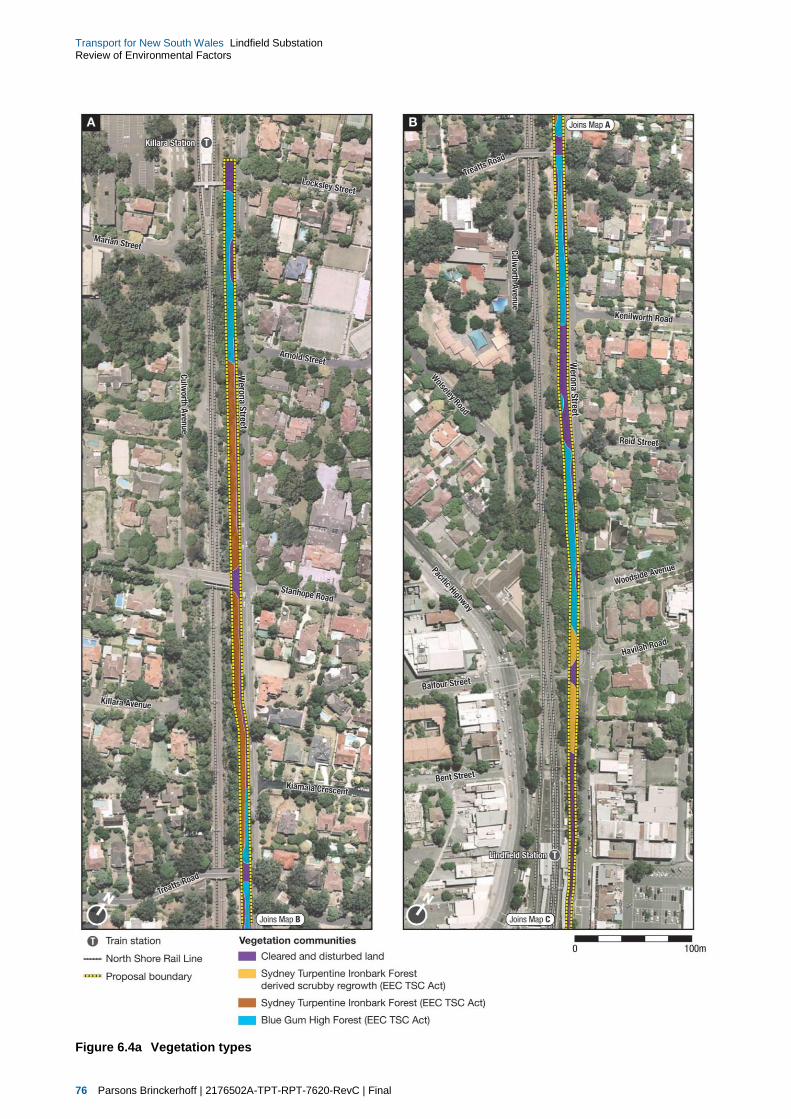
76 Parsons Brinckerhoff | 2176502A-TPT-RPT-7620-RevC | Final
Transport for New South Wales Lindfield Substation Review of Environmental Factors
Figure 6.4a Vegetation types

Parsons Brinckerhoff | 2176502A-TPT-RPT-7620-RevC | Final 77
Transport for New South Wales Lindfield Substation Review of Environmental Factors
Figure 6.4b Vegetation types

78 Parsons Brinckerhoff | 2176502A-TPT-RPT-7620-RevC | Final
Transport for New South Wales Lindfield Substation Review of Environmental Factors
6.4.3 Potential impacts on biodiversity from on the substation site
Loss of vegetation
Clearing of native vegetation is listed as a key threatening process under both the TSC Act and the EPBC
Act. Based on the assumption that the ‘additional aerial earth (overhead) wires only’ section of the proposed
will impact the vegetation to the north of Lindfield Station the construction of the proposal would require the
removal of approximately 0.94 hectares (50 square metres) of native vegetation from the proposal site, refer
to Table 6.16. In the likelihood that power poles are not replaced as part of the proposed this area of
vegetation removed will be reduced.
Table 6.16 Potential impacts and loss of native vegetation within the proposal site
Vegetation community/Fauna habitat Vegetation clearing (ha)
Vegetation community
Blue Gum High Forest 0.36
Sydney Turpentine Ironbark Forest scrubby regrowth 0.58
Cleared and disturbed land (including scrubby regrowth) 1.37
Total area of vegetation communities 2.31
Total area of endangered ecological community* 0.94
Fauna habitat
Cleared land with scrubby regrowth 1.69
Forest 0.62
Total Fauna habitats 2.31
*Forms part of the endangered ecological community, Turpentine-Ironbark Forest and critically endangered Blue Gum High Forest as listed under the TSC Act
As a result of clearing and the loss of vegetation and habitats, a range of direct and indirect ecological
impacts may occur. These include:
reduction in the extent of vegetation communities and associated habitats
loss of local populations of species
fragmentation or isolation of remnants of vegetation communities or local populations of individual
species
increased edge effects and habitat for invasive species
reduction in the viability of ecological communities resulting from loss or disruption of ecological
functions (e.g. increased desiccation, light penetration, herbivore, weed invasion, predation, parasitism)
destruction of flora and fauna habitat and associated loss of biological diversity (habitat removal may
include removal of hollow bearing trees, loss of leaf litter layer, and resultant changes to soil biota)
soil exposure and altered water flow patterns resulting in increased erosion and sedimentation.
The proposal would have an impact on fauna habitats with the removal or modification of approximately
2.31 hectares of habitat which is in low to moderate condition and may provide some marginal foraging
habitat for several threatened species of birds and bats.

Parsons Brinckerhoff | 2176502A-TPT-RPT-7620-RevC | Final 79
Transport for New South Wales Lindfield Substation Review of Environmental Factors
Direct loss of fauna
During the construction of the substation, direct injury or death to fauna could occur as a result of the
proposed activities particularly during the excavation and site clearing activities. Some mobile species, such
as birds, have the potential to move away from the path of clearing, while other species that are less mobile
may have difficulty moving over relatively large distances. Species of animal that may be at particularly high
risk of injury or death during vegetation clearing include microchiropteran bats, reptiles, nestling birds and
frogs. Appropriate mitigation measures would be implemented to reduce the potential for fauna mortality
during construction of the substation.
Habitat fragmentation impacts
Habitat fragmentation is the division of a single area of habitat into two or more smaller areas, with the
occurrence of a new habitat type in the area between the fragments. Due to the existing highly fragmented
nature of the study area it is considered unlikely that the proposed construction would increase
fragmentation, isolation or barrier effects further.
Environmental noise impacts
Various species of animals rely on sound to communicate, navigate, evade danger and find food. Although
ambient noises are part of the natural environment, some human-made noise can alter the behaviour of
animals or interfere with their normal functioning. During construction, noise levels will increase in the study
area and surrounds due to ground disturbance, machinery operation and vehicle movements and vegetation
clearing. This may cause disturbance for some fauna.
The study area is already affected by noise levels associated with vehicle movements along the railway
corridor and adjacent arterial roads. Specific impacts to fauna occupying the local area as a result of
construction noise is difficult to predict, however given the current minimal habitat on site and the existing
noise environment, any impacts are likely to be minor.
Weed and pest invasion
The construction of the substation has the potential to disperse weeds into new areas. The most likely
causes of weed dispersal associated with the proposed construction activities would include earthworks,
movement of soil and attachment of seed (and other propagules) to vehicles and machinery.
The process of weed dispersal may also reduce the habitat quality of threatened species, such as woodland
species of bird. The invasion of exotic perennial grasses, such as Nassella neesiana*, Bromus catharticus*,
Paspalum dilatatum* and Pennisetum clandestinum* which were recorded within the existing road corridor, is
recognised as a Key Threatening Process under the TSC Act.
The invasion and establishment of escaped garden plants, exotic vines and scramblers and other exotic
species (i.e. Lantana camara and Olea europaea subsp. cuspidata) which were recorded within the existing
rail corridor are recognised as Key Threatening Processes under the TSC Act.
Given the moderate level of weed invasion, and the presence of fifteen noxious weeds, within the majority of
the rail corridor, construction, has the potential to spread weeds from the study area to other sites.
Therefore mitigation measures relating to weed control have been outlined in section 6.4.5 of this report.

80 Parsons Brinckerhoff | 2176502A-TPT-RPT-7620-RevC | Final
Transport for New South Wales Lindfield Substation Review of Environmental Factors
Key threatening processes
A process is defined as a key threatening process under the TSC Act and EPBC Act if it threatens or may
threaten the survival, abundance, or evolutionary development of a native species or ecological community.
The proposal has the potential to contribute to the following threatening processes:
Key Threatening Processes (TSC Act):
invasion of native plant communities by exotic perennial grasses
clearing of native vegetation
loss and degradation of native plant and animal habitat by invasion of escaped garden plants,
including aquatic plants
Invasion, establishment and spread of Lantana camara
Invasion of native plant communities by African Olive Olea europaea L. subsp. cuspidata
Invasion and establishment of exotic vines and scramblers
Key Threatening Processes (EPBC Act):
land clearance
loss and degradation of native plant and animal habitat by invasion of escaped garden plants,
including aquatic plants.
The proposal would result in the loss of native vegetation and thus contribute to the Key Threatening
Process of clearing of native vegetation and land clearance. The proposal is not likely to significantly
increase the introduction or spread of exotic weed species, if undertaken in accordance with mitigation
measures provided below.
Impact assessments were completed for all of the threatened biodiversity considered to have a moderate or
higher likelihood to occur. Completed significance assessments are provided in Appendix E in Technical
Paper 4. Due to the small area and highly modified condition of the vegetation and habitat recorded within
the study area the impact assessments concluded that the proposal is not likely to have a significant impact
on any threatened biodiversity, nor would it interfere with their recovery, assuming the mitigation measures
outlined in section 6.4.4 are put in place.
6.4.4 Management and mitigation measures
As part of CEMP, a vegetation management plan would be developed to address potential biodiversity
impacts. The following measures would be implemented during construction activities to ensure ecological
impacts are minimised:
biodiversity offset requirements:
although the impacts to threatened biodiversity are not considered to be significant, the proposed
project would result in residual impacts that cannot be avoided or mitigated. Based on the worst
case scenario (i.e. vegetation within the entire ‘additional aerial earth (overhead) wires only’ section
of the project area will require removal in addition to the main works area), these impacts are
associated with the clearing of 0.94 hectares of native vegetation To mitigate these residual
impacts it would be necessary to develop an offset strategy in accordance with the requirements of
Transport for NSW ‘Vegetation Offset Guide’ (Transport for NSW 2014), in particular the offset
strategy should aim to;
– replace/offset 100 per cent of any native vegetation cleared
– achieve a neutral or beneficial long-term ecological outcome when native vegetation is cleared
the final offset strategy and quantum of offset requirement will be developed in consultation with
Transport for NSW on completion of construction
Parsons Brinckerhoff | 2176502A-TPT-RPT-7620-RevC | Final 81
Transport for New South Wales Lindfield Substation Review of Environmental Factors
implement pre-clearing protocols, including:
check for the presence of flora and fauna species and habitat on site before clearing begins such
as the presence of bird nests
prior to construction, site personnel should be adequately informed of environmental management
procedures including, but not limited to, issues related to flora and fauna management, weed
control, erosion and sediment control
establish exclusion zones to protect vegetation and fauna habitat outside of the assessed and
approved clearing limits, including the threatened ecological communities recorded within the study
area (including Blue Gum High Forest and Sydney Turpentine Ironbark Forest scrubby regrowth).
Vegetation to be retained are to be clearly defined on ground and ‘no go zones’ clearly signposted
and fenced to prevent unauthorised clearing and vehicular and/foot traffic
implement clearing and construction protocols, including:
carefully clear vegetation so as not to mix topsoil with debris and to avoid impacts to surrounding
native vegetation
avoid excessive soil disturbance
when accessing construction sites, contractors should only use designated access tracks
implement flora and fauna control measures including:
clearing of vegetation would be minimised, to only vegetation that is absolutely required to be
removed in order to undertake work
replace power poles only were necessary and appropriate to do so as to reduce impacts to
biodiversity
noxious weeds within the study area such as Ligustrum lucidum* (Broad-leaved Privet),
Cinnamomum camphora* (Camphor Laurel), Asparagus aethiopicus* (Asparagus Fern), Lantana
camara* (Lantana), Ligustrum spp. (Privet), Nassella neesiana* (Chilean Needle Grass),
Tradescantia albiflora* (Wandering Dew) and Rubus fruiticosus* (Blackberry) would be managed in
accordance with the Noxious Weeds Act 1993.
weed species within the study area would be managed in order to control them from further spread.
Management techniques may include immediate weed removal and disposal without stockpiling,
disposal of weed-contaminated soils at appropriate weed disposal facilities and to ensure that all
equipment is cleaned prior to and on completion of works to ensure weeds are not introduced or spread
to other locations.
6.5 Land use, property and socio-economic
6.5.1 Existing environment
As described in section 2.3.2, land use and development within the vicinity of the proposal is controlled
through the zoning provisions of the Ku-Ring-Gai Local Environmental Plan (Local Centres) 2012. Under this
LEP, the proposed Lindfield substation and associated cable relocation works would be located within the
existing rail corridor on land zone SP2 Railway Infrastructure. As the whole of the proposal site is within the
existing rail corridor, the property is owned and operated by Sydney Trains.
The land use adjacent to the substation site and associated cable relocation works typically consists of low to
medium-density residential housing to the east, west and south of the proposal site. The main town centre of
Lindfield, including light industrial and commercial uses are located to the north of the substation site.
The broader study area includes a mix of land uses which are characteristic of both suburban and business
park settings, including residential, commercial, industrial, recreation, education, infrastructure and parks and
reserves.

82 Parsons Brinckerhoff | 2176502A-TPT-RPT-7620-RevC | Final
Transport for New South Wales Lindfield Substation Review of Environmental Factors
Photos of the key land uses within the vicinity of the proposal site are provided in Figure 6.5 to Figure 6.8.
The key land uses within the vicinity of the proposal site are shown in Figure 6.9a and Figure 6.9b.
Figure 6.5 Example of low density residential housing to the south of the proposal site
Source: Envisage consulting, 2014
Figure 6.6 Example of medium density residential housing to the west of the proposal site
Source: Envisage consulting, 2014

Parsons Brinckerhoff | 2176502A-TPT-RPT-7620-RevC | Final 83
Transport for New South Wales Lindfield Substation Review of Environmental Factors
Figure 6.7 Example of the medium density residential housing which overlooks the proposal site to the west
Source: Envisage consulting, 2014
Figure 6.8 Example of the medium density residential housing which overlooks the proposal site to the west
Source: Envisage consulting, 2014

84 Parsons Brinckerhoff | 2176502A-TPT-RPT-7620-RevC | Final
Transport for New South Wales Lindfield Substation Review of Environmental Factors
Figure 6.9a Key land use within the vicinity of the proposal site

Parsons Brinckerhoff | 2176502A-TPT-RPT-7620-RevC | Final 85
Transport for New South Wales Lindfield Substation Review of Environmental Factors
Figure 6.9b Key land use within the vicinity of the proposal site

86 Parsons Brinckerhoff | 2176502A-TPT-RPT-7620-RevC | Final
Transport for New South Wales Lindfield Substation Review of Environmental Factors
Socio-economic
It is unlikely that there would be any significant social impacts as a result of the proposal. Notwithstanding,
the construction of the new substation would ensure that the reliability of the Sydney Trains network to cater
for the increased capacity during peak hour on the North Shore Line is maintained.
An assessment of the potential social and economic impacts of the proposal was undertaken as part of
this REF. Table 6.17 summarises the conclusions of the assessment in relation to the potential construction
impacts, including consideration of management and mitigation measures to reduce the identified impacts.
Table 6.17 Summary of potential social and economic impacts during construction
Potential impact Potential impact without mitigation Potential impact with mitigation
Impacts to businesses
Relating to the potential loss or relocation of businesses due to the proposal.
No impact
Given the location of the proposal, no businesses are located within the immediate vicinity of the proposal that would be affected by the proposal.
None required.
Noise and vibration
Relating to the potential loss amenity for residential properties and businesses due to the construction of the proposal.
Slight negative
Some potentially sensitive residential noise receivers have been identified adjacent to the substation site that would be impacted slightly during construction and operation.
No business or commercial properties have been identified within the immediate vicinity that may be impacted by construction related noise and vibration.
Slight negative
Standard mitigation measures would be implemented during construction to minimise noise and vibration amenity impacts (refer to section 6.2 of this REF).
Mitigation measures such as shielding and design of the substation would also be investigated during detailed design to minimise noise and vibration impacts during operation of the substation.
Traffic, access and parking
Relating to the availability of car parking for customers and employee and increases in construction related traffic.
Slight negative
Construction workers could potentially park on nearby streets reducing the amount of parking available for existing customers and workers.
Additionally, approximately two to four existing parking spaces along Lindfield Avenue may be lost due to the relocation of the existing rail corridor access point associated with the proposed Lindfield substation.
Slight negative
To limit construction workers parking in surrounding streets, where feasible and safe to do so, parking for some vehicles would be provided within the proposal site/within the rail corridor adjacent to the proposal site.
Short term impacts would be further minimised through the implementation of a CEMP and CTMPs.
Increased demand for goods and services
Demand for local goods and services from the construction industry.
Slight positive
Some businesses within the Lindfield town centre may experience a slight positive benefit from additional customers resulting from the construction activities and additional workers in the locality.
None required
Employment generation
Relating to the generation of construction employment as a direct and indirect consequence of the project.
Slight positive
Employment generation benefits would occur on commencement of the project’s planning, design and construction work.
None required
Economic multipliers
Relating to economic activity in one industry and the flow on benefits to others across the national economy.
Slight positive
Benefits of construction and job generation would flow through to the wider economy on commencement of the project’s planning, design and construction work.
None required

Parsons Brinckerhoff | 2176502A-TPT-RPT-7620-RevC | Final 87
Transport for New South Wales Lindfield Substation Review of Environmental Factors
6.5.2 Operational impacts
There would be no changes to land use as a result of the operation of the proposal. All of the proposed
works would occur within the existing rail corridor and would not impact on other existing land uses during
operation.
The proposal is not expected to stimulate any change to land uses adjacent to the railway corridor or have
any socio-economic impacts.
6.5.3 Management and mitigation measures
Given the minor impact of the proposal on existing land uses, no specific management and mitigation
measures are proposed to be implemented during construction or operation of the proposal.
Mitigation measures which would reduce the amenity impacts of construction are outlined throughout the
remainder of this REF.
6.6 Water quality, hydrology, drainage
6.6.1 Existing environment
The proposal site for the Lindfield substation and associated electrical works falls within the Sydney Harbour
and Parramatta River Catchment area. This area extends from Blacktown in the west, Sydney Harbour
National Park in the east, Marrickville to the south and Warringah to the north. The proposal site is situated
approximately two kilometres to the north east of the Lane Cove River, which is a tributary of the Parramatta
River.
No other surface waterways have been identified within the vicinity of the proposal.
6.6.2 Construction impacts
The potential impacts from the proposed construction works on water quality would mainly comprise the
pollution of stormwater run-off with sediments, fuels and other hazardous materials from the proposal site.
The following potential water quality impacts could result from activities associated with the construction of
the proposal:
Earthworks and excavation activities – the construction of the substation earthworks, excavation
activities and installation of the new CSR would create opportunities for stockpiled material and
excavated soils to erode causing sedimentation of water runoff entering drainage systems and
potentially increasing sediment loads into urban drainage systems. In addition, fuels from vehicles, plant
and machinery operated around the substation site could potentially spill and leak. Any potential fuel
spills could leach into exposed ground surfaces causing soil contamination or enter drainage systems
polluting receiving waterways.
Accidental chemical spills and leaks – accidental chemical spills and leaks associated with the
transportation, use and storage of hazardous materials could contaminate stormwater run-off from the
substation site. Spillage of diesel, lubricating oils or other chemicals could occur during refuelling and/or
maintenance of construction vehicles, while leakage of fuels or oils could occur from poorly maintained
construction vehicles. However with the appropriate mitigation measure in place these impacts are
unlikely.

88 Parsons Brinckerhoff | 2176502A-TPT-RPT-7620-RevC | Final
Transport for New South Wales Lindfield Substation Review of Environmental Factors
6.6.3 Operational impacts
As a result of the construction of the Lindfield substation and new CSR in existing vegetated areas,
stormwater runoff would potentially be increased as a result of the increase in hardstand area. During the
operation stage of the substation the quality of water should not be impacted. All rainfall runoff would be from
sealed or stabilised areas and would enter the council stormwater system via a new drainage system as
described in section 5.3.1 of this REF. The stormwater run-off expected from the substation is unlikely to
exceed the capacity of the existing system as only a small amount of vegetation would be removed from the
proposal site and replaced with sealed surfaces, however the proposal would discharge volumes of water
into the existing infrastructure at a rate that complies with the Ku-Ring-Gai Council limits.
In addition to the increase in potential runoff, accidental spills and leaks associated with the use and storage
of hazardous substances within the substation site could contaminate stormwater run-off. Spillage of diesel,
lubricating oils or other chemicals could occur during substation maintenance activities potentially impacting
the water quality of receiving waterways.
6.6.4 Management and mitigation measures
As part of the CEMP, a water quality management plan would be developed to address potential soil and
water quality management on the substation site. The following management and mitigation measures would
be implemented as part of the water quality management plan to minimise the potential impacts of the
proposal:
Construction
The following management and mitigation measures would be implemented to minimise water quality
impacts during the construction of the proposal:
no stockpiles of materials or storage of fuels or chemicals would be located adjacent to existing culverts
vehicles and machinery would be properly maintained to minimise the risk of fuel/oil leaks
routine inspections of all construction vehicles and equipment would be undertaken for evidence of
fuel/oil leaks
all water discharges would be undertaken in accordance with Transport for NSW’s Water Discharge and
Re-use Guideline
construction plant, vehicles and equipment would be refuelled off-site, or in designated re-fuelling areas
located at a minimum distance of 50 metres from drainage lines or waterways
the existing Sydney Trains and Council drainage systems would remain operational throughout the
construction of the project
stabilised surfaces would be reinstated as quickly as practicable after construction
material transport from site to surrounding pavement surfaces would be minimised
drainage will be installed to carry stormwater collected on site and connected into existing council
stormwater infrastructure.
Further mitigation measures regarding particular impacts relating to water and soil management are provided
in section 6.7.4 below.
Operation
Operational water quality impacts from the substation site would be managed in accordance with Sydney
Trains’ existing environmental management system.

Parsons Brinckerhoff | 2176502A-TPT-RPT-7620-RevC | Final 89
Transport for New South Wales Lindfield Substation Review of Environmental Factors
6.7 Soils and contamination
6.7.1 Existing environment
Soils
The study area is located within the broad sandstone plateau of the Sydney Basin. The sandstone geology is
generally overlaid on the broader portions of the ridge crest landforms by Ashfield Shale. Soils across the
gently sloping crest landforms would largely be residual in nature, with some colluvial movement on slopes
and fluvial deposition associated with watercourses.
Contamination
The substation would be constructed on a section of vacant land within the North Shore Line rail corridor at
Lindfield. It is likely that in recent history, this land would have been used by Sydney Trains as a storage
area for equipment, machinery construction materials and other miscellaneous items as necessary.
The remainder of the proposed works, including realignment of the existing high voltage aerial feeder lines, is
also within the existing rail corridor.
There is no registered contamination within the substation site. However, given the likely history of the site
and proximity within an active rail corridor, there may be some potential for contaminated soils within the
proposal site. The most likely source of potential soil contamination would be a result of any storage or use
of hydrocarbons and fuels within the proposal site. Management measures would be undertaken during the
excavation and construction works to assess the area for contamination so that any contaminated material
can be safety removed from site.
6.7.2 Construction impacts
The impacts on soils within the substation site would be due to excavation works carried out as part of the
substation foundation works as well as for the creation of pits and footing. Where possible, spoil generated
would be used on site to provide the required levels. However, spoil that cannot be used would be sent for
recycling or disposal to a licensed facility. During the construction of the Lindfield substation, a substantial
amount of excavation would be required (approximately 4,500 cubic metres). Some of this excavation may
be suitable for reuse within other part of the substation site for elements such as access tracks.
The proposal also has the potential to impact negatively on the surrounding environment due to excavations
that may lead to erosion and sediment transfer offsite and contamination issues associated with hydrocarbon
spills as a result of plant operating within the proposal. If any contaminated material is found, it would be
removed as part of the works in accordance with the waste classification guidelines. A contamination
management plan would be incorporated into the CEMP to minimise any impacts of contamination and its
removal.
Given the site characteristics and the scope and size of the proposal, it is anticipated that erosion and
sediment risks are minimal and can be effectively managed through the implementation of standard
measures as outlined in the Landcom Managing Urban Stormwater, Soils and Construction Guidelines
(Landcom 2004).
6.7.3 Operational impacts
Some potential contamination risks could arise from potential spillages/leakages of fuels and oils used within
the substation site. These impacts would be managed through the implementation of Sydney Trains standard
operational procedures.
90 Parsons Brinckerhoff | 2176502A-TPT-RPT-7620-RevC | Final
Transport for New South Wales Lindfield Substation Review of Environmental Factors
6.7.4 Management and mitigation measures
The following management and mitigation measures would be implemented to minimise contamination
impact pre-construction and during the construction of the proposal:
Soils
an Erosion and Sedimentation Control Plan (ESCP) will be developed and maintained for the site in
accordance with Managing Urban Stormwater, Soils and Construction Guidelines (Landcom, 2004) (the
Blue Book). The plan will include site access controls preventing tracking of sediment from site, limiting
the removal of groundcover and ensuring that the excavation works do not block natural drains or create
undrained areas
all material required for off-site disposal is to be appropriately tested and classified against the Waste
Classification Guidelines prior to being disposed of off-site (DECC, 2008)
excavated material will be reassessed for reuse onsite
site rehabilitation of disturbed areas to be undertaken progressively as activities are completed during
the proposal.
Contamination
the CEMP would include a contamination management plan and an asbestos management plan
all fuels, chemicals and hazardous liquids would be stored within an impervious bunded area in
accordance with Australian standards and EPA Guidelines
spill kits and a temporary refuelling bund will be installed and used onsite
if fill material is discovered during excavation works, the material should remain on-site where possible
(where contaminant concentrations meet the National Environment Protection Council’s National
Environment Protection (Assessment of Site Contamination) Measure 1999
should any signs of contamination be identified during work within the site, the material would be tested
against the National Environment Protection Council’s National Environment Protection (Assessment of
Site Contamination) Measure 1999, and managed accordingly
a hazardous materials inspection is to be undertaken of any areas where historical infrastructure is to be
demolished to assess the materials for the presence of asbestos and/or lead paint. If present,
appropriate management measures would be implemented for safe removal
soil excavated in areas with identified surrounding industrial land uses (including former uses) is to be
assessed for either its potential re-use on-site or classified for waste disposal purposes. If groundwater
is encountered during the works, groundwater quality is to be investigated and appropriate management
measures implemented to avoid further impacts
procedures for handling asbestos contaminated materials (if found on site), including record keeping,
site personnel awareness and waste disposal would be undertaken in accordance with WorkCover
requirements.

Parsons Brinckerhoff | 2176502A-TPT-RPT-7620-RevC | Final 91
Transport for New South Wales Lindfield Substation Review of Environmental Factors
6.8 Non-Indigenous heritage
A non-Indigenous statement of heritage impact (SoHI) has been prepared by Artefact Heritage (June 2014)
and is included as Technical Paper 5 (Artefact 2014a). A summary of the assessment is provided in this
section.
6.8.1 Methodology
The study area for the assessment of non-Indigenous heritage was identified as including the area of
proposed impact (the proposal site) and a 100 metre buffer surrounding this site. Heritage items within
100 metres of the proposed impact area were also included in this assessment to ensure that all potential
impacts to the context and setting of the heritage items were taken into consideration.
A search of existing heritage items within the study area was undertaken through a search of the following
heritage lists and registers:
World Heritage List
National Heritage List
State Heritage Register
Section 170 Registers, under the NSW Heritage Act 1977 (‘the Heritage Act’)
local environmental plans (LEPs):
Ku-Ring-Gai Planning Scheme Ordinance 2013 (‘Ku-Ring-Gai PSO’),
Draft Ku-Ring-Gai Local Environmental Plan 2013 (‘Draft Ku-Ring-Gai LEP’)
Register of the National Trust.
Documentary research was conducted to investigate the general history of the locality, as well as the history
of the heritage-listed items within the study area. The following libraries and archives were consulted:
State Library of NSW
National Library of Australia, including maps and newspaper archives
Land and Property Information Division, including the Parish Map Preservation Project and aerial
photographs.
Following this research, an initial site inspection was conducted on 4 December 2013 to verify the desktop
assessment and identify and inspect any visible heritage items, with additional confirmation site visits
undertaken on 20 March 2014 and 24 June 2014. Based on this information obtained, assessments of
significance for each of the identified heritage items within the study area were prepared in accordance with
the NSW Heritage Assessment Guidelines (included in the NSW Heritage Manual, Heritage Office and
Department of Urban Affairs & Planning 1996).
6.8.2 Existing non-Indigenous heritage
Lindfield was originally the traditional land of the Ku-Ring-Gai, or Guringai people. The name of the suburb
and Railway Station was taken from the name of a cottage constructed by an early settler in the region,
Francis John List. The focus of the suburb of Lindfield was originally on the Lane Cove River where a
government convict timber-getting camp was established around 1810, known as the Lane Cover Sawing
Establishment. The railway line was established in 1890, increasing and diversifying the population as
Lindfield began to be increasingly suburbanised. Further discussion of the historical context of the proposal
site is provided in Chapter 4 of the SoHI (Technical Paper 5).

92 Parsons Brinckerhoff | 2176502A-TPT-RPT-7620-RevC | Final
Transport for New South Wales Lindfield Substation Review of Environmental Factors
Heritage listings
World Heritage List
No items listed on the World Heritage List were identified within the study area.
National Heritage List
No items listed on the National Heritage List were identified within the study area.
State Heritage Register
A single item within the study area is listed on the SHR being a residential property known as ‘Woodlands’
(SHR No 01762)
Section 170 Registers
No items listed on Sydney Train’s Section 170 were identified within the study area.
Register of the National Trust
No items listed on the Register of the National Trust were identified within the study area.
LEP listings
Four heritage-listed items which are located within or adjacent to the proposal site:
Ku-ring-gai Local Environmental Plan (Local Centres) 2012
Item No. I41 Commercial Block
Item No. I42: ‘Laurabada’, dwelling house
Item No. I55: St Alban’s Anglican Church
Item No. C27 Blenheim Road Conservation Area
Draft Ku-ring-gai Local Environmental Plan 2013 (LEP)
Item No. I1106 Killara Railway Station Group
Item No. I407 Killara Post Office
Item No. I391 Dwelling House at 23 Stanhope Road
Item No. I393 ‘Mooralbeck’ Dwelling House at 29 Stanhope Road
Item No. I405 ‘Woodlands’ Dwelling House at 1 Werona Avenue
Item No. I483 Dwelling House at 6 Waimea Road
Item No. I482 Dwelling House at 4 Waimea Road
Item No. C92: Clanville Conservation Area
Item No. C26 Oliver Grant Conservation Area
Item No. C21 Springdale Conservation Area
These items are summarised in Table 6.18. A map of the identified heritage sites within the vicinity of the
proposal site are shown in Figure 6.10a and Figure 6.10b.
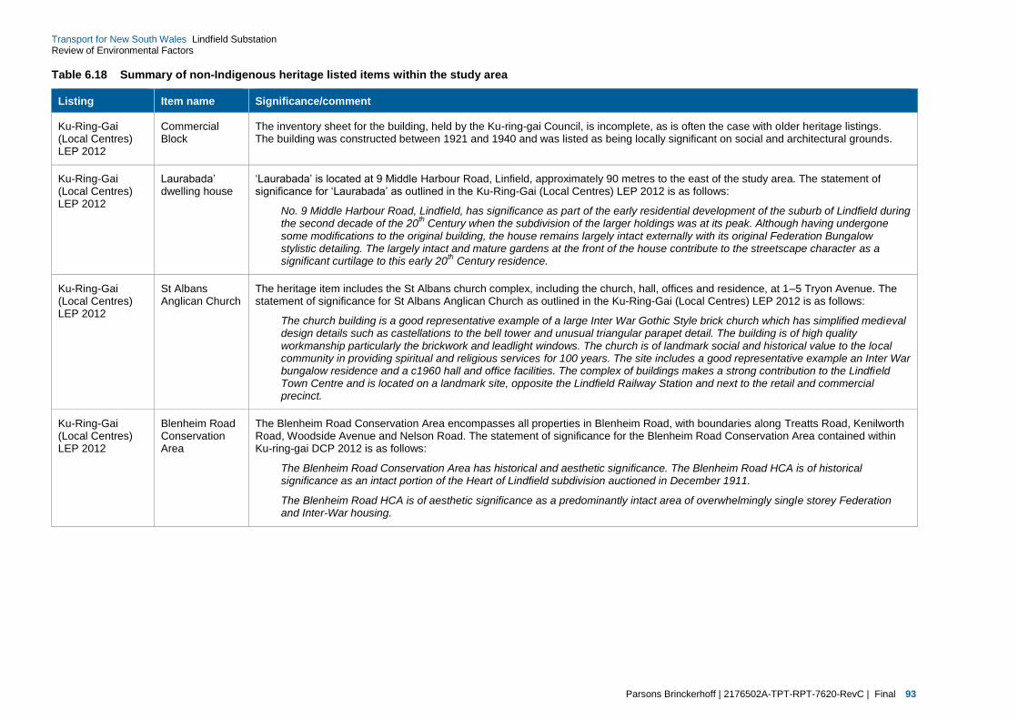
Parsons Brinckerhoff | 2176502A-TPT-RPT-7620-RevC | Final 93
Transport for New South Wales Lindfield Substation Review of Environmental Factors
Table 6.18 Summary of non-Indigenous heritage listed items within the study area
Listing Item name Significance/comment
Ku-Ring-Gai (Local Centres) LEP 2012
Commercial Block
The inventory sheet for the building, held by the Ku-ring-gai Council, is incomplete, as is often the case with older heritage listings. The building was constructed between 1921 and 1940 and was listed as being locally significant on social and architectural grounds.
Ku-Ring-Gai (Local Centres) LEP 2012
Laurabada’ dwelling house
‘Laurabada’ is located at 9 Middle Harbour Road, Linfield, approximately 90 metres to the east of the study area. The statement of significance for ‘Laurabada’ as outlined in the Ku-Ring-Gai (Local Centres) LEP 2012 is as follows:
No. 9 Middle Harbour Road, Lindfield, has significance as part of the early residential development of the suburb of Lindfield during the second decade of the 20
th Century when the subdivision of the larger holdings was at its peak. Although having undergone
some modifications to the original building, the house remains largely intact externally with its original Federation Bungalow stylistic detailing. The largely intact and mature gardens at the front of the house contribute to the streetscape character as a significant curtilage to this early 20
th Century residence.
Ku-Ring-Gai (Local Centres) LEP 2012
St Albans Anglican Church
The heritage item includes the St Albans church complex, including the church, hall, offices and residence, at 1–5 Tryon Avenue. The statement of significance for St Albans Anglican Church as outlined in the Ku-Ring-Gai (Local Centres) LEP 2012 is as follows:
The church building is a good representative example of a large Inter War Gothic Style brick church which has simplified medieval design details such as castellations to the bell tower and unusual triangular parapet detail. The building is of high quality workmanship particularly the brickwork and leadlight windows. The church is of landmark social and historical value to the local community in providing spiritual and religious services for 100 years. The site includes a good representative example an Inter War bungalow residence and a c1960 hall and office facilities. The complex of buildings makes a strong contribution to the Lindfield Town Centre and is located on a landmark site, opposite the Lindfield Railway Station and next to the retail and commercial precinct.
Ku-Ring-Gai (Local Centres) LEP 2012
Blenheim Road Conservation Area
The Blenheim Road Conservation Area encompasses all properties in Blenheim Road, with boundaries along Treatts Road, Kenilworth Road, Woodside Avenue and Nelson Road. The statement of significance for the Blenheim Road Conservation Area contained within Ku-ring-gai DCP 2012 is as follows:
The Blenheim Road Conservation Area has historical and aesthetic significance. The Blenheim Road HCA is of historical significance as an intact portion of the Heart of Lindfield subdivision auctioned in December 1911.
The Blenheim Road HCA is of aesthetic significance as a predominantly intact area of overwhelmingly single storey Federation and Inter-War housing.

94 Parsons Brinckerhoff | 2176502A-TPT-RPT-7620-RevC | Final
Transport for New South Wales Lindfield Substation Review of Environmental Factors
Listing Item name Significance/comment
Draft Ku-Ring-Gai LEP 2013
Killara Railway Station Group
The Killara Railway Station is located in a suburban setting away from the Pacific Highway between Werona Avenue and Culworth Avenue. It is enclosed by mature trees that line both sides of these roads. The station consists of an early twentieth century station building, modern steel awnings, an island platform, footbridge, and a well maintained ornamental garden on the eastern side. The statement of significance for the Killara Railway Station Group obtained from the SHI listing for the item is as follows:
Killara Railway Station has heritage significance at a local level. It is a typical suburban station with associated ornamental gardens, and one of the few stations in the region where there has been relatively little change to the appearance of the overall setting. It is one of a number of stations that demonstrate the significant impact of the railway in facilitating settlement in the northern suburbs of Sydney and is an important station on the first purely suburban line in NSW. The station has local significance in terms of its association with the formerly prestigious Railway Stations Gardens Competition. It is one of the most important and intact railway gardens in the region. The grouping of the station building, platform and footbridge in their landscape setting, contribute to the characteristic nature of the North Shore line, with its homogenous early twentieth century station designs and garden settings. The replacement of the original roof form of the station building with a poorly designed substitute structure detracts from the overall setting and significance.
Draft Ku-Ring-Gai LEP 2013
Killara Post Office
The former Killara Post Office, along with the ornamental garden of the Killara Railway Station, forms part of small but significant suburban heritage precinct.
The inventory sheet for the building, held by the Ku-ring-gai Council, is incomplete, as is often the case with older heritage listings.
Draft Ku-Ring-Gai LEP 2013
Dwelling House at 23 Stanhope Road
The heritage listing for this item is incomplete. It was constructed between 1901 and 1920. The statement of significance for this item, taken from its inventory listing on the SHI states that that item has architectural, group value and municipal significance.
Draft Ku-Ring-Gai LEP 2013
‘Mooralbeck’ Dwelling House at 29 Stanhope Road
The building occupying Lot 1, 29 Stanhope Road is a two storey, early twentieth century building, constructed in the Federation Arts and Crafts style and is referred to in the Heritage study area of the Municipality of Ku-ring-gai as Item No. 28:064. It represents a fine example of Federation Arts and Crafts architecture and it remains in largely original condition both externally and internally. It may date from 1907.
The building features an upright styling with a steeply pitched, terra cotta tiles roof set behind prominent decorative gables. Large box windows feature on most elevations. Walls are of red face brickwork at the lower level and stuccoed in the Federation fashion above a stringer course. A number of small out buildings exist on the site but these are not significant structures and most probably date from the period 1921-1938.
The statement of significance for Mooralbeck, obtained from a Statement of Heritage Impact for the property, is as follows:
The building is of historical significance for its links to the residential development of Killara after 1890. The building is of aesthetic significance as it is a fine example of a Federation Arts and Crafts period building which remains largely intact.

Parsons Brinckerhoff | 2176502A-TPT-RPT-7620-RevC | Final 95
Transport for New South Wales Lindfield Substation Review of Environmental Factors
Listing Item name Significance/comment
Draft Ku-Ring-Gai LEP 2013
‘Woodlands’ Dwelling House at 1 Werona Avenue
‘Woodlands’ (formerly known as ‘Inglewood’) is situated on approximately 2113 metre square corner block bound by Kiamala Crescent to the north and Werona Avenue to the west. The original entrance is marked by two palm trees. Subdivision of the property has altered the original front boundary. In its original form (circa 1800) the house was a two storey square brick building reminiscent of the Victorian Georgian style. The statement of significance for ‘Woodlands’ obtained from the SHR listing for the item is as follows:
The c.1884 ‘Woodlands’ (originally known as ‘Inglewood’) is of State heritage significance for its historical association with the acclaimed Australian children’s author Ethel Turner (1870-1958) whose most famous literary work ‘Seven Little Australians’ was written during Turner’s occupancy of the property. Ethel Turner lived at ‘Woodlands’ with her family from September 1891 to December 1894. During this period she wrote three books: her first and most famous children’s novel ‘Seven Little Australians’, its sequel ‘The Family at Misrule’, and ‘The Story of a Baby’. ‘Seven Little Australians’ and its sequel were strongly influenced by the social and domestic environment of ‘Woodlands’ and it natural surroundings creating a provocative portrayal of children and Australian identity in the late 19th century.
‘Seven Little Australians’ has been in print for well over 100 years. It has sold over several million copies in the English language. It has been translated into at least 13 languages, performed as stage play and been made into a film, a BBC television series in 1953, a 10 episode television series for the ABD in 1973 and a musical in 1988. ‘Woodlands’ is one of the earlier substantial Ku-ring-gai residences pre-dating the Hornsby to St Leonards railway line which opened in 1890. The two storey late Victorian Georgian style house demonstrates many aspects of the Federation Filigree style having been remodelled during the Federation period. It provides a rare example of the layering of the Victorian and Federation era styles in domestic architecture.
Draft Ku-Ring-Gai LEP 2013
Dwelling House at 6 Waimea Road
The heritage listing for this item is incomplete. It was constructed between 1901 and 1920. The statement of significance for this item, taken from its inventory listing on the SHI states that that item has architectural, group value and municipal significance.
Draft Ku-Ring-Gai LEP 2013
Dwelling House at 4 Waimea Road
The heritage listing for this item is incomplete. It was constructed between 1901 and 1920. The statement of significance for this item, taken from its inventory listing on the SHI states that that item has architectural, group value and municipal significance.
Draft Ku-Ring-Gai LEP 2013
Clanville Conservation Area
Located to the south of Chelmsford Avenue, only a small portion of the Clanville Conservation Area is in the study area. Views from the conservation area into the proposed Lindfield substation site are largely obscured by vegetation. The statement of significance for the Clanville Conservation Area contained within Ku-Ring-Gai Draft LEP 2013 is as follows:
The Clanville HCA has high historic significance as the David Dering Mathew grant of 400 acres called ‘Clanville’, whose boundaries are evident through the following streets; Archbold Road, Boundary Street, Pacific Highway and Tryon Road. Successive subdivisions in the late 19
th century were spurred by the development of the North Shore Railway Line in 1890–1893.
This subdivision reflects improved transport connections due to the construction of the North Shore Railway Line. Further subdivisions took place in the early twentieth century.
The HCA has high aesthetic significance as a cohesive early twentieth century and Interwar development and for the high proportion of quality houses.

96 Parsons Brinckerhoff | 2176502A-TPT-RPT-7620-RevC | Final
Transport for New South Wales Lindfield Substation Review of Environmental Factors
Listing Item name Significance/comment
Draft Ku-Ring-Gai LEP 2013
Oliver Grant Conservation Area
The topography of the Oliver Grant Heritage Conservation Area is generally elevated. The streets are perpendicular to the railway line. Lorne Avenue reflects the alignment of a creek to the North. The street grid is distorted by the alignment of Lorne Avenue. The lots are inconsistent due to this alignment and due to layers of re-subdivision. The statement of significance for the Oliver Grant Conservation Area contained within Ku-Ring-Gai Draft LEP 2013 is as follows:
The Oliver Grant HCA forms part of the 45-acre Henry Oliver grant later divided into three farms. The grant boundaries are evident through the following streets: Stanhope Road, Pacific Highway and Treatts Road. The HCA has high historic significance for tis early twentieth century subdivisions of Killara Park estate (1904) and Restholm Estate (1902). These subdivisions reflect improved transport connections due to the construction of the North Shire railway Line. The HCA has medium historic significance for the overlay of Interwar subdivision evidence in the lots on the southern side of Stanhope Road and some houses. This later subdivision reflects improved transport connections due to the construction of the Sydney Harbour Bridge and the electrification of the railway in 1927.
The HCA has high aesthetic significance as a reasonably intact late nineteenth century and early twentieth century development, and high aesthetic significance for the high proportion of quality houses.
Draft Ku-Ring-Gai LEP 2013
Springdale Conservation Area
The Springdale Heritage Conservation Area consists of one and two-storey Interwar development with remnant of c1920 Federation houses. The statement of significance for the Oliver Grant Conservation Area contained within Ku-Ring-Gai Draft LEP 2013 is as follows:
The Springdale Heritage Conservation Area has high historic significance as the 1839 160 acres of Jane Bradley’s Springdale grant whose boundaries are evident through the following streets: Karanga Avenue, Locksley Street, Roseberry Road, Stanhope Road and the Pacific Highway. Jane Bradley married James McGillvray in 1830. The HCA has high historic significance as a late nineteenth century subdivision of the Springdale Estate evident in the lots and fine houses. The HCA reflects improved transport connections due to the construction of the North Shire Rail line and the opening of Killara Station in 1899 The consolidation of development reflects improved transport connections due to the electrification of the railway in 1927 and the construction of the Sydney Harbour Bridge. The HCA has high aesthetic significance as a cohesive late nineteenth and early twentieth century development for its high proportion of quality of houses.

Parsons Brinckerhoff | 2176502A-TPT-RPT-7620-RevC | Final 97
Transport for New South Wales Lindfield Substation Review of Environmental Factors
Figure 6.10a Identified heritage sites within the vicinity of the proposal site

98 Parsons Brinckerhoff | 2176502A-TPT-RPT-7620-RevC | Final
Transport for New South Wales Lindfield Substation Review of Environmental Factors
Figure 6.10b Identified heritage sites within the vicinity of the proposal site

Parsons Brinckerhoff | 2176502A-TPT-RPT-7620-RevC | Final 99
Transport for New South Wales Lindfield Substation Review of Environmental Factors
6.8.3 Assessment of archaeological and research potential
Known impacts in the study area
The study area has been occupied by the railway line and surrounding residential properties from the late
19th century. The study area is likely to have been subject to impacts that may have affected the potential
archaeological resource. The impacts may have included, but are not limited to, the following:
increasing residential density in the Lindfield area achieved through subdivision
the widening and formalisation of the Pacific Highway
early 20th century construction impacts from the residences to the eats and the south of the study area.
This may have involved the excavation of footing trenches and ground levelling
the establishment of Lindfield Avenue in the early 20th
century
the establishment of the North Shore railway line in the late 19th century. The construction of the line in
the study area would have involved substantial excavation and ground modification that would have
resulted in the displacement of any potential archaeological remains
the relocation of the existing power lines and in-ground electrical services relating to the railway.
Assessment of archaeological potential
Archaeological potential is defined as the potential of a site to contain archaeological relics, as classified
under the Heritage Act. Archaeological potential is assessed by identifying former land uses and associated
features through historical research, and evaluating whether subsequent actions may have impacted on
evidence for these former land uses.
The Clanville estate, granted in 1819, was originally utilised for its timber resources. It is likely that this period
of intensive timber felling lasted into the mid-19th century. After this resource had been exhausted, the
property was planted with citrus. Therefore archaeological remains from this period of the estate are likely to
include evidence of the types of plants established within the property, structural remains such as fencing,
water managements systems (dams and channels) and evidence of landscape modification (vegetation
clearance, earth movement). Archaeological remains associated with these types of activities tend to be
extremely ephemeral.
Analysis of historic plans of Lindfield indicates that the Clanville estate remained relatively intact into the
early 20th century. The Clanville estate contained a single structure in the early to mid-19
th century,
constructed during Richard Archbold’s ownership of the property. This structure was located outside and to
the south of the current study area. Later maps do not indicate that additional structures were located within
the Clanville estate (although this is not uncommon in Parish maps, which do not tend to show structures),
and it is likely that the study area did not contain any substantial structures until it was subdivided in the early
20th century. Therefore, the study area is unlikely to contain substantial archaeological remains associated
with residential occupation.
Due to the substantial impact caused by the construction of Lindfield Avenue and the railway line, and the
unlikeliness of encountering ephemeral remains associated with earliest agricultural use of the Clanville
estate, it is highly unlikely that archaeological remains would have survived within the study area.
Overall, the study area has little to no archaeological potential.

100 Parsons Brinckerhoff | 2176502A-TPT-RPT-7620-RevC | Final
Transport for New South Wales Lindfield Substation Review of Environmental Factors
6.8.4 Impacts on non-Indigenous heritage
With the exception of vistas and views to and from heritage items, the current proposal would have no impact
on potential archaeological resources or heritage buildings within the study area. The potential impacts of the
proposal on heritage items within the study area are discussed below.
Commercial block
The commercial block is located on the eastern side of Lindfield Avenue from the railway corridor and is
located in an area where the only impact would be the installation of an additional overhead wire to the
existing power poles. As the poles are existing, there would be no additional visual impact on this heritage
item.
The proposal would therefore have no impact on the heritage significance of the item.
‘Laurabada’ dwelling house
‘Laurabada’ is located over 100 metres to the east of the proposed substation building. Visual connections
between the proposal and the heritage item are therefore limited. This view corridor is further obscured by
the mature street plantings alongside the road corridor on Middle Harbour Road.
The proposal adheres to the recommendations for management of ‘Laurabada’ outlined in the inventory
sheet for the heritage item, included in the Ku-ring-gai (Local Centres) LEP 2012 and would therefore have
no impact on the heritage significance of ‘Laurabada.’
St Albans Anglican Church
The site comprising a complex of church, residence and hall has a high level of social, aesthetic and
historical significance to the local community. The visual connections between the church complex and the
proposed substation site, however, are extremely limited. Lindfield Avenue rises slightly to the south a rise
that mostly obscures the study area. Mature street plantings further obscure this view corridor. The
significant view corridor towards the church is to the south from the Lindfield Railway Station and town
centre, located further north. The rear view of the church complex is heavily vegetated. The proposed
substation would not visually dominate the church, or reduce views to or from the church, or from the public
realm.
The proposal adheres to the to the recommendations for management outlined in the inventory sheet for the
heritage item, included in the Ku-ring-gai (Local Centres) LEP 2012 and would therefore have no impact on
the heritage significance of ‘St Albans Anglican Church’.
Blenheim Road Heritage Conservation Area
The Blenheim Road is located on the eastern side of Lindfield Avenue, which separates the item from the
study area and the railway corridor. It is located in an area where the only impact would be the installation of
an additional overhead wire to the existing power poles. As the poles are existing, there would be no
additional visual impact on this heritage item. The proposal would therefore have no impact on the heritage
significance of the item.
The Killara Railway Station Group
The Killara Railway Station Group is located immediately north of the proposal study area. The only impact in
this location would be the installation of an additional overhead wire to the existing power poles. As the poles
are existing, there would be no additional visual impact on this heritage item. The proposal would therefore
have no impact on the heritage significance of the item.
Parsons Brinckerhoff | 2176502A-TPT-RPT-7620-RevC | Final 101
Transport for New South Wales Lindfield Substation Review of Environmental Factors
The Killara Post Office
The Killara Post Office is located on the eastern side of Werona Avenue, which separates the item from the
study area and the railway corridor. It is located in an area where the only impact would be the installation of
an additional overhead wire to the existing power poles. As the poles are existing, there would be no
additional visual impact on this heritage item. The proposal would therefore have no impact on the heritage
significance of the item.
Dwelling houses at 23 and 29 Stanhope Road and ‘Woodlands’
The heritage items are located on the eastern side of Lindfield Avenue, which separates the item from the
study area and the railway corridor. It is located in an area where the only impact would be the installation of
an additional overhead wire to the existing power poles. As the poles are existing, there would be no
additional visual impact on this heritage item. The proposal would therefore have no impact on the heritage
significance of the items.
Dwelling houses at 4 and 6 Waimea Road
The houses at 4 and 6 Waimea Road are oriented to the south-west and towards the railway corridor;
however, direct views towards are obscured by the high bank of the rail line in this location. The heritage
items are located in an area where the only impact would be the removal of existing overhead power lines
and their replacement with in-ground services. The proposal would therefore have no impact on the heritage
significance of the items.
Clanville Heritage Conservation Area
The proposed location of the substation site is to the immediate north of the Clanville Heritage Conservation
Area. The proposed substation would be clearly visible from Strickland Avenue, where it crosses the railway
line, and immediately north of the heritage conservation area (HCA). There is a clear visual connection
between the northernmost portion of the HCA and the southernmost portion of the proposed substation.
The installation of security fencing and retaining wall, and the construction of the substation building itself,
would be the most visually intrusive elements of the proposal. However, this view of the substation site would
only affect the residence at the intersection of Lindfield and Strickland Avenues, which is screened from
Strickland Avenue, and therefore the substation site, by a substantial garden. The visual impact of the HCA
is therefore considered to be acceptable if measures are taken to minimise visual impacts by establishing
screening vegetation and using sympathetic finished where possible.
Oliver Grant Heritage Conservation Area
The heritage items are located on the eastern side of Lindfield Avenue, which separates the item from the
study area and the railway corridor. It is located in an area where the only impact would be the installation of
an additional overhead wire to the existing power poles. As the poles are existing, there would be no
additional visual impact on this heritage item. The proposal would therefore have no impact on the heritage
significance of the item.
Springdale Heritage Conservation Area
The heritage items are located on the eastern side of Lindfield Avenue, which separates the item from the
study area and the railway corridor. It is located in an area where the only impact would be the installation of
an additional overhead wire to the existing power poles. As the poles are existing, there would be no
additional visual impact on this heritage item. The proposal would therefore have no impact on the heritage
significance of the item.

102 Parsons Brinckerhoff | 2176502A-TPT-RPT-7620-RevC | Final
Transport for New South Wales Lindfield Substation Review of Environmental Factors
Table 6.19 provides a summary of potential heritage constraints on the proposal. This includes impacts to
heritage buildings and fabric, impacts to the potential archaeological resource within the study area and
potential impacts on views and vistas.
Table 6.19 Potential heritage constraints of the proposal
Item name
Potential heritage constraints
On heritage buildings/fabric
On potential archaeology
On views and vistas
Commercial Block None None None
‘Laurabada’ dwelling house
None None None
St Albans Anglican Church
None None None
Blenheim Road HCA None None None
Killara Railway Station Group
None None None
Killara Post Office None None None
Dwelling House at 23 Stanhope Road
None None None
‘Mooralbeck’ None None None
‘Woodlands’ None None None
Dwelling House at 6 Waimea Road
None None None
Dwelling House at 4 Waimea Road
None None None
Clanville Conservation Area
None None The proposed substation, security fencing and retaining wall would all be clearly visible from the northern most portion of the HCA, although this is screened by existing plantings.
Oliver Grant HCA None None None
Springdale HCA None None None
Overall statement of heritage impact
Table 6.20 provides an overall statement of heritage impact for the proposed works.
Table 6.20 Potential heritage constraints of the proposal
Development Discussion
What aspects of the proposal respect or enhance the heritage significance of the study area?
The proposal, as a whole, would not have a negative impact on the heritage items contained within the study area, on any potential archaeological remains, or on the heritage significance of the study area as a whole. There is extremely limited visual connection between ‘Laurabada’ and St Albans Church. The works would not impact on the heritage significance of these items.
There is a visual connection between the northernmost portion of the Clanville HCA and the substation site. However this view would only affect the residence at the intersection of Lindfield and Strickland Avenues, which is screened from Strickland Avenue, and the substation site, by a substantial garden. The visual impact of the HCA is therefore considered to be acceptable if measures are taken to minimise visual impacts by establishing screening vegetation and using sympathetic finished where possible.

Parsons Brinckerhoff | 2176502A-TPT-RPT-7620-RevC | Final 103
Transport for New South Wales Lindfield Substation Review of Environmental Factors
Development Discussion
What aspects of the proposal could have a detrimental impact on the heritage significance of the study area?
The proposal is unlikely to have a detrimental impact on the heritage items included within the study area. There are no impacts to heritage fabric, and the study area does not have archaeological potential.
Visual impacts of the proposal on the Clanville HCA are considered acceptable.
Have more sympathetic options been considered and discounted?
The proposal is considered to have minimal potential impacts to existing heritage and conservation items. No additional sympathetic options have been considered to be required.
6.8.5 Management and mitigation measures
The heritage significance of the majority of listed items adjacent to or within the study area would not be
affected by the proposal, and would therefore not require specific mitigation measures.
The Clanville HCA is located to the south of the substation site. There are some visual constraints in this
location although the negative impact of the proposal on the HCA is considered to be minor. These minor
impacts could be mitigated by introducing screening vegetation at the completion of works and taking care in
the choice of sympathetic finishes and elevations.
The following recommendations have been made regarding potential impact of the proposal on the Clanville
HCA:
Care should be taken to make the substation building as unobtrusive as possible. This can be achieved
by completing the roofing and walls in dark colours, sympathetic to the surrounding area.
The lower the substation is in the landscape, the less visual impact it would have on the HCA, and the
surrounding Lindfield area.
Consideration should be given toward introducing screening vegetation along the southern boundary of
the substation site at the completion of works.
6.9 Aboriginal heritage
An Aboriginal heritage Due Diligence Assessment June 2014 has been prepared by Artefact Heritage and is
included as Technical Paper 6 (Artefact 2014b). A summary of the assessment is provided in the following
sections.
6.9.1 Methodology
The Aboriginal heritage assessment was prepared using the OEH Code of Practice for Archaeological
Investigation of Aboriginal Objects in New South Wales (2010) (the ‘code of practice’) as best practice.
However, the report does not conform to the code of practice as it does not include systematic survey
coverage of each buffer area (due to access limitations), an impact assessment, a significance assessment,
or consultation with the Metropolitan Local Aboriginal Land Council (MLALC).
A search of the OEH Aboriginal Heritage Information Management System (AHIMS) database was
conducted on 2 December 2013, based on a 50 metre buffer area of the proposal. Site surveys of the study
area were undertaken on 20 March 2014 and 24 June 2014.

104 Parsons Brinckerhoff | 2176502A-TPT-RPT-7620-RevC | Final
Transport for New South Wales Lindfield Substation Review of Environmental Factors
6.9.2 Existing Aboriginal heritage
Aboriginal historical background
Prior to the appropriation of their land by Europeans, Aboriginal people lived in small family or clan groups
that were associated with particular territories or places. Territorial boundaries were likely to be fairly fluid,
although details are not known. The language group spoken on the Cumberland Plain is known as Darug
(Dharruk – alternative spelling). The Darug language group is thought to have extended from Appin in the
south to the Hawkesbury River, west of the Georges River, Parramatta, Lane Cove River and to Berowra
Creek. The area was home to a number of different clan groups throughout the Cumberland Plain.
The study area is within the territory of the Wallumedegal (or Wallumattagal) clan. The exact boundaries of
the territory are not known, and may have been fluid, but the Wallumedegal area is thought to have extended
around Sydney Harbour from Lane Cove along the northern bank of the Parramatta River.
European appropriation of Wallumedegal territory occurred very early in the colonisation period. Boats were
sent along the harbour up the Lane Cove and Parramatta Rivers within days of the arrival of the First Fleet.
Numerous overland parties quickly arrived to explore the potential of land surrounding the harbour.
Information about the way that Aboriginal people lived before European settlement can be gained from
observations of these early parties of explorers. From 1790, any Aboriginal people remaining in the Ryde
area would have been further disenfranchised, as convicts were moved in to harvest the timber and lime
resources of the area.
Registered Aboriginal heritage sites in the study area
A search of the AHIMS database (2 December 2013) identified a total of 70 Aboriginal sites within a 50 metre
buffer (the AHIMS search area), refer. No recorded Aboriginal sites were identified to be located within the
study area.
The most frequently recorded Aboriginal site types within the AHIMS search area include art sites (pigment
or engraved) (n=19), artefact sites (n=17), and midden sites (n=15). Other site types identified in the area
include potential archaeological deposit (PAD), grinding grooves, and habitation structures.
Seventy sites were located within the AHIMS search area, with none located within the study areas. Of the
70 sites recorded within the AHIMS search area, 36 are listed as closed sites and 34 as open sites. A closed
site context indicates the site is located within a shelter or overhang, formations which occur amongst
suitable outcropping sandstone in the local area. Site types within shelter formations include midden and/or
stone artefacts within the floor deposit, pigment or charcoal art on shelter walls, and engravings and/or
grinding grooves. Open site contexts indicate site types that have not been identified in a shelter formation,
and can include artefact and midden sites.
The variety of site types in the local context, and their association with both open and closed site contexts,
demonstrates the variability of Aboriginal settlement history of the area, and the use of subsistence
resources from the local watercourses and use of sandstone shelter formations.
Archaeological context of the study area
Archaeological data gathered in the locality has demonstrated the widespread and varying use of the area by
Aboriginal people. This predictive model comprises a series of statements about the nature and distribution
of evidence of Aboriginal land use that is expected in the study area. The substation site is located across
broad crest and gently sloping landform contexts and not in close proximity to the major watercourses of the
area. No recorded Aboriginal sites have been identified within the study area. The most likely site type to
occur within the study areas would be isolated artefacts or concentrations of artefacts in those areas, such
as public reserves, where there is the possibility of surface exposure and a lesser degree of surface
disturbance.

Parsons Brinckerhoff | 2176502A-TPT-RPT-7620-RevC | Final 105
Transport for New South Wales Lindfield Substation Review of Environmental Factors
6.9.3 Potential Aboriginal heritage impacts
The site of the proposed substation was found to be highly disturbed with extensive ground level modification
evident. The cut and fill across the site of the proposed substation has occurred as a result of the
construction of the adjacent railway line and Middle Harbour Road.
The study area to the north of the substation site was primarily adjacent to Werona Avenue, or within the rail
corridor. This section of the study area was found to be highly disturbed and no areas of archaeological
potential were identified.
The study area to the south of the substation site is located along the eastern side of the rail corridor.
The majority of this section of the study area was found to be highly disturbed. A small section of the study
area between power pole P50 and power pole P51 appeared to be less disturbed and may contain remnant
landform. This area did not exhibit any evidence for Aboriginal archaeological potential as it is not within the
vicinity of permanent water and did not include a sensitive landform unit.
The aim of the due diligence assessment undertaken was to assess whether any Aboriginal objects or areas
of archaeological potential are located within the study area, to assess whether any Aboriginal objects or
areas of archaeological potential are likely to be impacted by the proposal, and if so to recommend whether
further investigation is required.
The archaeological sensitivity of the study area was found to be low due to high levels of ground disturbance
and modification. As the proposal site has been found to be of low archaeological sensitivity there are
unlikely to be impacts to Aboriginal heritage values as a result of the proposal.
6.9.4 Management and mitigation measures
The following management and mitigation measures would be implemented to minimise impacts on
Aboriginal heritage:
If suspected Aboriginal objects are located during construction, an archaeologist would be notified to
assess the nature and significance of the find. If the find is and Aboriginal object, further investigation
and permits may be required before works commence. If the find is an Aboriginal object OEH and the
MLALC would be notified.
If suspected human skeletal remains were uncovered at any time within the study area, the following
actions would need to be followed:
immediately cease all excavation activity in the vicinity of the remains
notify NSW Police
notify OEH via the Environment Line on 131 555 to provide details of the remains and their location
no recommencement of activity in the vicinity of the remains unless authorised in writing by
OEH.
6.10 Waste and resource management
This section provides an overview of typical waste streams that would be generated during construction and
operation of the proposed substation and associated cabling works at Lindfield and appropriate waste
management or mitigation measures.

106 Parsons Brinckerhoff | 2176502A-TPT-RPT-7620-RevC | Final
Transport for New South Wales Lindfield Substation Review of Environmental Factors
6.10.1 Construction impacts
Waste sources
As a result of the construction of the proposal, the following key waste sources would be generated:
green waste from vegetation clearance within the substation site
excess spoil from excavations works (the estimated earthworks volume for the Lindfield substation
based on the current draft substation layout is 4500 cubic metres)
solid waste, including any construction and demolition waste such as removed signalling,
communications and electrical cabling and systems, station infrastructure and signage as well as any
solid wastes generated from internal changes to station buildings and office fit-outs
liquid waste such as oils and used chemicals from equipment maintenance
domestic waste from site personnel including food scraps, glass and plastic bottles, paper and plastic
containers
site sewage and other wastewater run-off including water utilised for dust suppression.
Resource use
Materials selection and use
The proposal would require a wide range of materials during construction including spoil, steel, plastics,
paints, concrete, ballast, aggregate, cabling and timber. Plants and mulch would also be required for
landscaping around the substation site. All opportunities to utilise recycled building materials in the overall
structure of the proposal would be explored.
All materials used in the construction of this project are common construction materials. The highest value
materials used in the proposal will be large amounts of copper used in the cabling and transformers housed
in the substation building although this metal is still abundant.
Energy and fuel use
Construction of the proposal would require the use of energy and fuels to power plant, equipment and
transport vehicles. Fuels would include non-renewable sources such as petroleum, diesel, natural gas and
liquefied natural gas.
Water
Water would be required during construction for dust suppression, compaction and pavement stabilisation
during earthworks, concrete batching, washing of plant and equipment, watering of landscaped areas, fire-
fighting (if required) and for staff facilities. Water would be reused on-site where practicable.
6.10.2 Operational impacts
Minimal operational waste or resource impacts are anticipated during the operation of the new substation.
The only waste generated during operation of the proposal would be related to periodic maintenance
activities. This would include materials such as electrical wiring that would be disposed of in accordance with
Sydney Trains existing procedures and DECC Waste Classification Guidelines (2008).

Parsons Brinckerhoff | 2176502A-TPT-RPT-7620-RevC | Final 107
Transport for New South Wales Lindfield Substation Review of Environmental Factors
6.10.3 Management and mitigation measures
A waste management plan would be prepared as part of the CEMP. Construction waste would be managed
through the waste hierarchy established under the Waste Avoidance and Recovery Act 2001, which
comprises the following principles:
1. Avoidance of waste — Minimise the amount of waste generated during construction by avoiding
unnecessary resource consumption (i.e. avoid the use of inefficient plant and construction equipment
and avoid materials with excess embodied energy, waste and excessive packaging).
2. Resource recovery — Reuse, reprocess and recycle waste products generated during construction to
minimise the amount of waste requiring disposal.
3. Disposal — Where resources cannot be recovered, dispose of them appropriately to minimise the
potential adverse environmental impacts.
All waste requiring off-site disposal would be classified in accordance with the OEH’s Waste Classification
Guidelines (DECCW 2009) prior to disposal. Further details of waste management measures are discussed
below. With implementation of these management measures, construction wastes would be largely reduced
such that no significant waste impacts are expected during the construction of the proposal.
The following key waste mitigation and management strategies would be implemented throughout the
construction of the proposal and would be governed by the CEMP:
where possible, construction wastes would be diverted from landfill and reused or recycled within the
proposal areas or through an appropriate recycling contractor
construction materials that contain minimal embodied energy would be utilised
construction materials would be purchased in accordance with an established procurement strategy that
prioritises the selection of materials that utilise best practice recycled material content and sustainability
ratings
site disturbance and unnecessary excavation would be minimised
materials from any demolition works would be reused or recycled where practicable
formwork would be reused where possible
sewage waste would be disposed of by a licensed waste contractor in accordance with Sydney Water
and OEH requirements.
6.11 Air quality
A qualitative assessment of potential air quality impacts resulting from the proposal has been undertaken.
A summary of the potential air quality impacts is provided below.
6.11.1 Existing air quality
Existing background air quality
Background air quality data from the OEH-operated Rozelle monitoring location has been adopted in
identifying background air quality. This monitoring station location is considered representative of the
proposal area, which includes residential and commercial land uses. Air quality data recorded from 2011 to
2012 was used to establish background air quality. The background air quality data adopted from the OEH
Rozelle location for the proposal is generally good and below criteria levels.

108 Parsons Brinckerhoff | 2176502A-TPT-RPT-7620-RevC | Final
Transport for New South Wales Lindfield Substation Review of Environmental Factors
Existing air emission sources
The substation site is located predominantly within a residential precinct. The ambient air quality of the
surrounding environment is dominated by proximity to the surrounding local streets and is fairly typical an
urban area. The predominant cause of local air pollution is vehicle exhaust.
Construction of the substation may result in dust impacts to nearby residents and the general public,
however will be limited in duration. A number of sources within the proposed project area have the potential
to influence the local air shed to varying degrees. These include, but are not limited to:
traffic emissions from the existing road networks (the greatest source of air pollution)
light commercial and general residential sources (including domestic wood heaters).
A search of the National Pollution Inventory database (NPI) at substation site was conducted to investigate
cumulative pollutants within the proposed project’s airshed. For the 2011/2012 reporting period there were
no individual facilities reporting within the vicinity of the proposed substation. The primary contributors to air
pollutant levels in the project are expected to be emissions from motor vehicles along arterial and local
roads. Air quality can also be influenced by naturally occurring events such as bushfires and dust storms.
Ambient concentrations of pollutants along the proposal corridor are expected to be primarily dependent on
local and regional weather conditions and overall regional air quality.
6.11.2 Potential air quality impacts during construction
During construction, the following key activities have the potential to generate air emissions. These activities
will have the following impacts for each set of works for the proposal:
During site establishment there is potential for high volumes of dust to be generated from bulk
earthworks. The substation site and a portion of the electrical works site would be cleared and grubbed,
excess material excavated and removed, then cut and filled. This will create dust emissions at the areas
being excavated or cleared.
Dust emissions may occur during the piling process for foundation works.
Gaseous vehicle emissions resulting from the use of vehicles and other machinery on site including:
trucks
cranes
front end loaders
bobcats
generators.
There could be potential for dust impacts during installation of cabling and traction supply feeders for
the proposed substation. The substation also requires also number of pits in be installed, creating
limited localised dust emissions.
The excavation works associated with the construction of the Lindfield substation have the greatest dust
generating potential of the proposed construction activities, however the impacts would be short-term and
readily controlled to minimise emissions. Although the qualitative assessment cannot confirm compliance
with relevant air quality criteria, anticipated levels of particulate matter are considered to be minor, temporary
and easily managed.
Parsons Brinckerhoff | 2176502A-TPT-RPT-7620-RevC | Final 109
Transport for New South Wales Lindfield Substation Review of Environmental Factors
The dispersion of particulate matter would depend on the meteorological conditions present during the
works, but it is expected that these particulate levels would drop significantly with distance. During
unfavourable meteorological conditions such as dry and windy conditions, particulate emissions may be
higher and would require specific corrective measures. The CEMP would identify triggers and procedures for
dealing with these conditions.
Particulate matter
During construction, the generation of particulate matter could affect the local ambient air environment.
Dust emission sources with potential to generate emissions during proposal construction include:
excavation and earthwork operations
wind erosion of freshly exposed areas
light vehicle movements in track work areas and on paved roads.
Dust generation would be primarily be limited to construction activities within the substation site and would
be expected to increase where higher dust generating activities are undertaken (such as excavation works).
The activity specific nature of construction and the high level of control available enable particulate matter
emissions to be effectively managed.
6.11.3 Potential air quality impacts during operation
The proposed substation at Lindfield would have almost no operating impacts as it is an electrical generation
and transmission system resulting in zero fuel combustion emissions, other than ongoing maintenance.
A very small amount of gaseous emissions would be expected during maintenance works once the
substation is operational. This is due to the substation undergoing monthly testing once it is commissioned
for service. Emission rates and impacts depend on the power output of any ancillary combustion engines, the
quality of the fuel, and condition of the combustion engine. Provided these factors are effectively managed
under the POEO Act, maintenance works of substation is not anticipated to cause adverse impacts given the
scant scheduling of these works.
6.11.4 Management and mitigation measures
The following management and mitigation measures would be implemented to minimise impacts on air
quality during construction of the proposal. The implementation of suitable mitigation and management
measures would control and reduce the extent of impacts experienced at nearby sensitive receivers.
The CEMP would include a range of mitigation measures, as well as trigger levels and required monitoring.
The following mitigation measures are recommended during the construction phase of works and should be
considered for inclusion within the CEMP:
dust minimisation measures would be developed and implemented prior to commencement of
construction
methods for management of emissions would be incorporated into proposal inductions, training and pre-
start talks
activities with the potential to cause significant emissions such as earthworks or track removal would be
identified in the CEMP. Work practices which minimise emissions during these activities should be
investigated and applied where reasonable and feasible

110 Parsons Brinckerhoff | 2176502A-TPT-RPT-7620-RevC | Final
Transport for New South Wales Lindfield Substation Review of Environmental Factors
during bulk earthworks, visual inspection for dust in periods of unfavourable meteorological conditions
(such as high wind events and dry weather) would be undertaken and where necessary the following
measures would be implemented:
apply water (or alternative measures) to exposed surfaces that are causing dust generation.
Surfaces may include any exposed surfaces (for example recently scraped/graded areas)
apply water to works related to removal of redundant equipment. Application rates should be
related to atmospheric conditions (e.g. prolonged dry periods)
dust-generating activities (particularly clearing and excavating) should be avoided or minimised
during dry and windy conditions
a mechanism for responding to complaints from the community would be put in place for the duration of
the construction phase
construction plant and equipment would be well maintained and regularly serviced so that vehicular
emissions remain within relevant air quality guidelines and standards
emissions from trucks and other heavy vehicles would be regulated in accordance with the
requirements prescribed in the National Environment Protection Measure (NEPM) (Diesel Vehicle
Emissions)
all construction vehicles would be ensured to be tuned to not release excessive level of smoke from the
exhaust and are compliant with OEH’s Smokey Vehicles Program under the POEO Act and (NSW)
Protection of the Environment and Operations Regulations 2010
strategies would be put in place to reduce usage of chemical and fuels in additional to using alternative
fuel technologies as recommended in the NSW Action for Air (NSW EPA 2009). Particular focus would
be on those products with the potential to release high levels of air toxics
during operation of the substation site, ancillary service vehicles and maintenance equipment would be
maintained and operated in accordance with the manufacturer’s requirements and the POEO Act.
6.12 Greenhouse gases
6.12.1 Existing environment
The sources of greenhouse gas emissions related to the proposal can be categorised as part of emissions of
three scope types, depending on the sources of these emissions. Table 6.21 describes these categories and
the probable sources of emissions.
Table 6.21 Emission scopes and sources
Emission scope
Type of emission Probable proposal source
Scope 1 Direct emissions within the boundary of the proposal operations, such as fuel combustion and manufacturing processes, or provision of supplementary energy such as generating electricity for onsite usage.
Construction phase:
fuel combustion emissions from construction plant and equipment
clearing site vegetation.
Operations phase:
substation maintenance activities.
Scope 2 Indirect emissions from consumption of purchased electricity, steam or heat purchased for the proposal but produced by another organisation.
Construction phase:
electricity used to operate site office(s).
Operations phase:
operations of substation and systems, such as lighting and signalling.

Parsons Brinckerhoff | 2176502A-TPT-RPT-7620-RevC | Final 111
Transport for New South Wales Lindfield Substation Review of Environmental Factors
Emission scope
Type of emission Probable proposal source
Scope 3 Indirect emissions from all other emissions that are a consequence of activities of the project but are not from sources owned/controlled by the proposal.
Construction phase:
embodied energy of construction materials
emissions from transporting such materials to and from site.
emissions from the extraction, production, transmission and distribution of fuel and electricity used onsite.
Operations phase:
embodied energy in maintenance materials.
6.12.2 Construction impacts
Greenhouse gas emissions may be emitted directly or indirectly. The direct greenhouse gas-generating
activities associated with construction include mobile vehicular emissions (particularly from using heavy
vehicles to move materials like spoil and concrete) and, depending on the extent required, removing
vegetation (Scope 1 emissions). Indirect greenhouse gas emissions as a result of the project would include
emissions associated with the consumption of electricity within site compounds and construction equipment,
extraction of diesel and the emissions embodied in the products used on-site, particularly steel and concrete
(Scope 2 emissions).
Typically, the operation of on-site machinery during construction works and general site operations account
for the majority of construction-related greenhouse gas emissions.
Expected greenhouse gas sources of construction emissions for the project would include:
combustion of fuel in construction plant, equipment and vehicles (direct emissions occurring on-site)
vegetation clearing (direct emissions from the decomposition of vegetative material and soil carbon
releases)
electricity used at the construction compound/worksite (electricity indirect emissions, occurring off-site at
the power station)
disposal of waste from construction staff and site compound (indirect emissions from the decomposition
of waste material, occurring off-site and waste disposal facilities)
indirect emissions embodied in key construction materials, including cement and steel (i.e. the energy
and resources that were consumed to produce a particular construction material).
The volume of greenhouse gas emissions that would be generated during construction would depend on the
quantity of construction materials consumed and the types of construction plant and equipment used.
6.12.3 Operational impacts
Operational greenhouse gas emissions would primarily be associated with the operation and maintenance of
the substation and associated infrastructure. Greenhouse gas emissions would predominantly be generated
by the following activities:
electricity consumption to power the substation, signalling, lighting, and communications systems
combustion of fuel in maintenance plant, equipment and vehicles where required (direct emissions
occurring on-site)

112 Parsons Brinckerhoff | 2176502A-TPT-RPT-7620-RevC | Final
Transport for New South Wales Lindfield Substation Review of Environmental Factors
disposal of waste from the substation
embodied energy (and associated greenhouse gas emissions) in materials used in the maintenance of
the substation infrastructure (the energy and resources that were consumed to produce a particular
construction material).
The operational life of the proposal is estimated to be approximately 60 years prior to being replaced with
new transformer units. It is conceivable that emissions would occur during any future demolition or possible
modification of the proposal. The timeframes and types of technologies/materials that will be used during
such processes are not yet known.
Overall, construction related greenhouse gas emissions and energy usage are considered to be manageable
through design and the application of standard mitigation measures, as outlined in section 6.12.4.
6.12.4 Management and mitigation measures
While it would not be possible to completely mitigate the generation of greenhouse gas emissions during
construction (due to the need to consume energy and resources), the amount of emissions could be reduced
by implementing the following mitigation measures:
purchasing electrical energy derived from a renewable energy source (where available)
using low greenhouse gas-intensive construction materials (where a suitable substitute for a high
greenhouse gas-intensive material is available)
adopting energy efficient work practices
identifying measures for mitigation as part of site inductions, training and pre-start talks
procuring construction services and materials locally to minimise the distance travelled and therefore
emissions of vehicles accessing the site
ensuring that deliveries are managed in an efficient manner to minimise the number of trips required
and therefore reduce the amount of emissions
implementing energy-efficient work practices, such as switching off construction plant, vehicles and
equipment when not in use to minimise idling
regularly monitoring, auditing and reporting on energy, resource use and associated greenhouse gas
emissions as part of the environmental reporting requirements specified within the CEMP
selecting materials during construction planning to ensure products that reduce embodied carbon are
considered and used
ensuring clearance of vegetation be limited to the minimum that is required for the project
ensuring all vegetation cleared be disposed of at a registered compost facility in the Sydney area and
that it is not to be sent to landfill or burnt.
Opportunities to reduce operational greenhouse gas emissions would be investigated during detailed design.
These opportunities could include purchasing electricity derived from a renewable energy source (where
available) or the use of photovoltaic powered lighting for security.

Parsons Brinckerhoff | 2176502A-TPT-RPT-7620-RevC | Final 113
Transport for New South Wales Lindfield Substation Review of Environmental Factors
6.13 Electric and magnetic fields
Electric and Magnetic Fields (EMFs) are invisible and found at acceptable levels everywhere electricity is
present.
The possibility of adverse health effects due to the EMF associated with electrical equipment has been the
subject of extensive research throughout the world. To date, while adverse health effects have not been
established, the possibility that they may exist cannot be ruled out. Given the inconclusive nature of the
science, it is considered that a prudent/precautionary approach continues to be the most appropriate
response in the circumstances. Under this approach, the operators of electricity infrastructure design and
construct their facilities to limit the intensity of the associated EMFs to be as low as reasonably practicable.
This is typically achieved by locating the equipment as far as is practicable from public areas.
At present the Australian electrical power industries adopt the draft Australian Radiation Protection and
Nuclear Safety Agency (ARPANSA) standard, which is closely aligned to the International Commission on
Non-Ionizing Radiation protection (ICNIRP) recommendations referenced in most international EMF
standards.
In recent years the profile of EMF exposure raised by the research has resulted in an increase in community
concerns over the long term health effects on people living and working nearby power lines and facilities
(particularly high voltage power lines).
There are two components to an electromagnetic field, the electric field and the magnetic field.
An electric field is a region where electric charges experience an invisible force due to the voltage on a
nearby conductor. The strength of this force, i.e. the electric field, is related to the source voltage and is
strongest close to the source. The electric field strength diminishes rapidly at locations away from the
electrical equipment.
A magnetic field is a region where electric charges experience an invisible force due to the flow of electricity,
commonly known as current, in nearby conductors. Unlike electric fields, magnetic fields are only present
when electric current is flowing. The strength of a magnetic field depends on the magnitude of the current
(measured in amps), and decreases rapidly at locations away from the electrical equipment.
The electrical equipment associated with the proposed substation would be contained in metal safety
enclosures, which would also serve to shield the public and operators from both AC and DC electric fields
associated with the electrical equipment. Accordingly, both the alternating and static electric field contribution
from the proposed substation would be negligible inside and outside the substations.
While electric fields are effectively shielded by conductive and semi-conductive (e.g. concrete) materials, this
is not the case with magnetic fields. Even highly conductive copper enclosures provide negligible shielding to
power frequency magnetic fields.
The ARPANSA has published a Draft Standard for exposure to magnetic fields which advocates a full-time
exposure limit of 1,000 mG (mG is a unit of measurement for magnetic strength), and a higher value for
occupational exposure.
The alternating field levels to which people may be exposed are greatest in the localised areas within the
substation near the 600 V transformer tails, the High Voltage AC switchgear and at cable risers where cables
run vertically up from below grounds level. These localised field levels decrease very quickly at small
distances from the cables and equipment.
EMF studies on similarly configured substations have concluded that the static magnetic field levels are well
below the general public guidelines.

114 Parsons Brinckerhoff | 2176502A-TPT-RPT-7620-RevC | Final
Transport for New South Wales Lindfield Substation Review of Environmental Factors
Overall the areas of higher field levels are highly localised to the immediate vicinity of the electrical
equipment and would be contained within the Transport for NSW property, and the likelihood of public
encountering any significant EMFs is low.
The ARPANSA, as part of the Health and Ageing Portfolio, is a Federal Government agency charged with
responsibility for protecting the health and safety of people, and the environment, from EMF. ARPANSA
advises that:
The scientific evidence does not firmly establish that exposure to 50 Hz electric and magnetic fields
found around the home, the office or near powerlines is a hazard to human health.
The construction of the substation has the potential to alter the electromagnetic field strength currently
experienced in the surrounding area, although not significantly. This is achieved by maximising the
separation distance between the substation and public areas. The EMF levels are not expected to increase
over and above the occupational or incidental exposure limits set by ARPANSA in their Draft Standard.
6.14 Sustainability
The National Strategy for Ecologically Sustainable Development (Department of Environment and Heritage
1992) defines ESD as ‘using, conserving and enhancing the community’s resources so that the ecological
processes, on which life depends, are maintained and the total quality of life, now and in the future, can be
increased’. The concept of ESD gives formal recognition to environmental and social considerations in
decision-making to ensure that current and future generations enjoy an environment that functions as well
as, or better than, the environment they inherit.
With respect to the proposed Lindfield substation, the detailed design of the proposal would ensure that it
complies with Transport for NSW’s NSW Sustainable Design Guidelines for Rail (Transport for NSW 2012).
The aim of this guideline is to deliver sustainable development practice by embedding sustainability
initiatives into the design process. Within the guideline, substations are defined as a ‘maintenance facility’
and as such the proposal must meet a series of compulsory and discretionary targets and requirements for
maintenance facilities.
The proposal would strive to meet all compulsory targets and any required discretionary targets in the
guidelines. Measures to meet the sustainability requirements of the guidelines would continue to be
investigated during the detailed design of the proposal, including consideration of design elements such as:
insulation
use of five-star appliances
ensuring climate change impacts are considered
reduction of waste
biodiversity offsetting in accordance with relevant Transport for NSW guidelines
water efficiency measures including the proposed use of on-site detention storage (as outlined in
Chapter 3).
The role of greenhouse gas emissions related to this proposal is also discussed in further detail in
section 6.12 of this REF.
Parsons Brinckerhoff | 2176502A-TPT-RPT-7620-RevC | Final 115
Transport for New South Wales Lindfield Substation Review of Environmental Factors
6.15 Cumulative impacts
6.15.1 Overview
Cumulative impacts could occur if the construction of the new Lindfield substation coincided with the
construction or operation of other local development, such as residential or commercial development, road
upgrades or other public utility works.
The significance of the potential cumulative impacts has been assessed in the following sections, with
consideration given to the location and timing of the potential developments. Where the timing of a
development was not known at the time of writing this REF, the assessment assumed a worst-case scenario
in that the proposal would coincide with that development.
6.15.2 Potential developments
To identify any potential developments, a review of the major projects listed on the NSW Planning and
Environment and the Ku-Ring-Gai Council websites was undertaken (as of 28 March 2014). Minor
developments (such as minor alterations to existing dwellings) have not been included in the assessment
due to the limited extent and nature those of works and, therefore, minimal interaction with the proposed
works.
One approved major development has been identified within the vicinity of the proposed substation proposal.
The proposed project application is for demolition of existing buildings, excavation, and construction of a six
and seven storey mixed use development comprising of retail uses and 102 residential apartments with two-
level basement car parking for up to 150 vehicles. The site is located at 23–37 Lindfield Avenue,
approximately 300 metres to the north of the proposal site for the new substation.
However, given the construction period for the proposal is between mid-2015 and mid-to late 2017, it is
considered that most of the approved developments identified in the current search would be completed by
this time and therefore would not affect the cumulative impacts of the proposal (or are geographically
separated to the extent that there is unlikely to be any immediate overlap of impacts). Therefore it is not
considered that this search would be representative of the potential cumulative construction impacts and
have not been further assessed. In addition, it is expected that other major developments would be proposed
and approved between now and the construction of the proposed works, the details of which are not yet
publicly available.
6.15.3 Construction cumulative impacts
Cumulative construction impacts may include:
increased construction vehicle traffic on public roads causing access issues, traffic congestion or travel
delays, increased air pollution around the construction work sites, particularly along Lindfield Avenue
(the substation site) and surrounding streets which provide access to the substation site and the
proposed major development
noise impacts from multiple construction works or construction vehicle traffic
increased loss of parking which would be used for construction vehicles
reduced local biodiversity as a result of vegetation clearing
reduced visual amenity to the local area due to multiple construction worksites.

116 Parsons Brinckerhoff | 2176502A-TPT-RPT-7620-RevC | Final
Transport for New South Wales Lindfield Substation Review of Environmental Factors
Sensitive receivers most likely to be affected by potential cumulative construction impacts are those located
in close proximity to the construction sites or along the proposed construction vehicle haulage route.
The severity of potential cumulative impacts on surrounding receivers would vary at any given time during
the construction period and would generally be dependent on factors such as:
the types of works being undertaken at each site at any one time
the duration of the works for each development
the sensitivity of the receiver.
Notwithstanding, it is noted that the construction of the proposal is anticipated to occur between 2016 and
2017 and therefore construction of many of the above developments may have been completed by this time.
The cumulative impacts of the proposal and the proposed residential development (or any other similar
developments which may be identified prior to commencement of construction) are unlikely to be significant.
During preparation of the CEMP for the proposal, Transport for NSW would liaise with the proponents for this
proposal to ensure that no potential significant impacts would result from cumulative construction activities.
6.15.4 Operational cumulative impacts
No cumulative operational impacts are likely to occur as a result of the operation of the proposed substation
at Lindfield.
6.15.5 Management and mitigation measures
The following management and mitigation measures would be implemented to minimise any cumulative
impacts:
The potential cumulative impacts associated with the proposal would be further considered as the
design develops and as further information regarding the location and timing of potential developments
is released. Environmental management measures would need to be developed and implemented as
required.
Transport for NSW would consult with the proponents of other major projects in the area at the time of
construction of the proposed substation to avoid any potential cumulative impacts.

Parsons Brinckerhoff | 2176502A-TPT-RPT-7620-RevC | Final 117
Transport for New South Wales Lindfield Substation Review of Environmental Factors
7. Environmental management
Transport for NSW’s ISO 14001 accredited environmental management system elements would be used to
manage the construction of a new traction substation and associated cable relocation at Lindfield
(‘the proposal’). The management system would provide the framework for implementing the environmental
management measures documented in this REF, and any conditions of other approvals, licences or permits.
7.1 Environmental management plans
7.1.1 Construction environmental management framework
The Construction Environmental Management Framework (CEMF – see Appendix A) sets out minimum
environmental, stakeholder and community management requirements for construction. It acts as a linking
document between the initiatives described in this REF documentation and further development and
implementation by contractors through individual Construction Environmental Management Plan(s) (CEMP)
(refer to section 7.1.2 below).
Contractors would be required to implement and adhere to the requirements of the Construction
Environmental Management Framework.
7.1.2 Construction environmental management plan
A CEMP would be prepared for the construction phase of the proposal. The CEMP would provide a
centralised mechanism through which all potential environmental impacts would be managed. The CEMP
would document mechanisms for demonstrating compliance with the commitments made in this REF, the
submissions report (to be prepared following the public exhibition of the REF), and other relevant statutory
approvals. The CEMP would outline a framework for the management of environmental impacts during
construction of the proposal. The plan would address (at a minimum) the following elements:
traffic management
noise and vibration management
air quality management (including dust suppression)
landscape and rehabilitation plan (for the substation site at Lindfield)
community and stakeholder involvement
Aboriginal and non-Indigenous heritage management
water and soil management (particularly for the substation site)
flora and fauna and weed management (for the substation site)
soil and erosion management
contamination and waste management.
It is anticipated that the contractor appointed to undertake the construction of the substation and associated
works would prepare a CEMP for the works which would be reviewed and endorsed by Transport for NSW
prior to the commencement of construction. It is also anticipated that Sydney Trains would be required to be
consulted during the preparation of all CEMP, due to the proposed work occurring within the rail corridor.

118 Parsons Brinckerhoff | 2176502A-TPT-RPT-7620-RevC | Final
Transport for New South Wales Lindfield Substation Review of Environmental Factors
7.1.3 Operational environmental management
During operation of the traction substation at Lindfield, environmental issues and impacts would be managed
by Sydney Trains under its existing environmental management system.
7.2 Management and mitigation measures
The REF has identified a range of environmental impacts that are likely to occur as a result of the proposal.
Tables 7.1 to 7.2 provide a summary of the environmental management measures that Transport for NSW
proposed to manage the potential environmental impacts associated with the construction and operation of
the proposed traction substation at Lindfield.
The safeguards and management commitments documented in Tables 7.1 to 7.2 may be revised in
response to submissions raised in response to the public display of this REF and/or design changes made
subsequent to the public exhibition of the REF. Transport for NSW would consider the final environmental
management commitments when making a determination on the proposal. Following project approval, the
finalised safeguards and management measures would guide subsequent phases of the proposal. The
contractors appointed for the construction of the traction substation at Lindfield would be required to
undertake all works in accordance with these environmental management measures.
7.2.1 Construction management
Environmental management measures to be implemented during the construction phase of the proposal are
listed in Table 7.1.
Table 7.1 Construction environmental management measures
ID number Environmental management measures
Traffic and transport
As part of CEMP, a CTMP would be developed to address construction traffic and transport management. The following management and mitigation measures would be implemented as part of the CTMP to minimise the traffic and transport impacts of the proposal:
traffic controllers positioned at access gates adjacent to residential areas and access driveways
road occupancy licences for temporary closure of roads would be obtained, where required
heavy vehicles would be restricted to the routes specified and route markers installed for heavy vehicles along designated routes
signs would be provided at the access point to the site assist in deliveries to the worksite
signs would be provided at the access point for pedestrian and cyclist guidance
traffic controllers would be located at the access point to direct vehicle movements, vehicle deliveries, pedestrians and cyclists, where required
an emergency response plan would be developed for construction traffic incidents
a pre- and post-construction assessment of road pavement assets would be conducted in areas likely to be used by construction traffic
public communications would be conducted to warn the community and local residents of vehicle movements and anticipated effects on the local road network relating to the site works
access to all private properties adjacent to the works would be maintained during construction
during project inductions, all heavy vehicle drivers would be provided with the emergency response plan for construction traffic incidents

Parsons Brinckerhoff | 2176502A-TPT-RPT-7620-RevC | Final 119
Transport for New South Wales Lindfield Substation Review of Environmental Factors
ID number Environmental management measures
road safety audits would be undertaken where required or deemed necessary
project staging, vehicle movement and scheduling, equipment and resourcing would be coordinated.
Noise and vibration
B.1 All construction works associated with the proposal would be managed in accordance with the Construction Noise and Vibration Strategy (CNVS) which has previously been developed for the NWRL (provided as Appendix B of Technical Paper 2). The CNVS documents the best-practice techniques specific to the proposal for managing construction noise and vibration, and implementing feasible and reasonable mitigation measures.
B.2 Mitigation measures which are considered appropriate for these works which could be implemented during construction include:
implementation of proactive community consultation measures
site inductions for all contractors
shielding of works using site hoardings
for construction concentrated in a single area, temporary acoustic fencing/barriers around the site perimeter would be considered where feasible and reasonable to mitigate off-site noise levels
restriction of noise intensive works to daytime and evening periods, where possible
where night works are required, these would be programmed to minimise the number of consecutive nights impacting the same receptors, where possible
avoiding the coincidence of noisy plant working simultaneously close together and adjacent to sensitive receptors would result in reduced noise emissions
equipment which is used intermittently is to be shutdown when not in use
where possible, the offset distance between noisy plant items and nearby noise sensitive receptors should be as great as possible
where possible, equipment with directional noise emissions should be oriented away from sensitive receptors
use of less noisy equipment
regular compliance checks on the noise emissions of all plant and machinery used for the proposal would indicate whether noise emissions from plant items were higher than predicted
reversing of equipment should be minimised so as to prevent nuisance caused by reversing alarms
respite periods.
Landscape and visual character
C.1 Mitigation measures which are considered appropriate for these works which could be implemented during construction include:
ensure any security fencing includes screening of the site from views from the outer boundary and if possible is not of a garish or light colour (if permitted)
minimise the storage of materials and construction machinery as far as possible
maintain site in an orderly and tidy fashion.
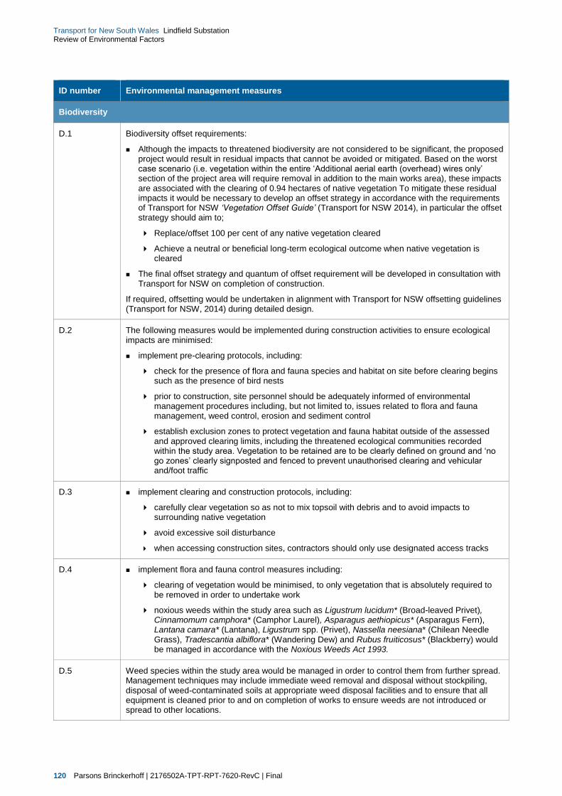
120 Parsons Brinckerhoff | 2176502A-TPT-RPT-7620-RevC | Final
Transport for New South Wales Lindfield Substation Review of Environmental Factors
ID number Environmental management measures
Biodiversity
D.1 Biodiversity offset requirements:
Although the impacts to threatened biodiversity are not considered to be significant, the proposed project would result in residual impacts that cannot be avoided or mitigated. Based on the worst case scenario (i.e. vegetation within the entire ‘Additional aerial earth (overhead) wires only’ section of the project area will require removal in addition to the main works area), these impacts are associated with the clearing of 0.94 hectares of native vegetation To mitigate these residual impacts it would be necessary to develop an offset strategy in accordance with the requirements of Transport for NSW ‘Vegetation Offset Guide’ (Transport for NSW 2014), in particular the offset strategy should aim to;
Replace/offset 100 per cent of any native vegetation cleared
Achieve a neutral or beneficial long-term ecological outcome when native vegetation is cleared
The final offset strategy and quantum of offset requirement will be developed in consultation with Transport for NSW on completion of construction.
If required, offsetting would be undertaken in alignment with Transport for NSW offsetting guidelines (Transport for NSW, 2014) during detailed design.
D.2 The following measures would be implemented during construction activities to ensure ecological impacts are minimised:
implement pre-clearing protocols, including:
check for the presence of flora and fauna species and habitat on site before clearing begins such as the presence of bird nests
prior to construction, site personnel should be adequately informed of environmental management procedures including, but not limited to, issues related to flora and fauna management, weed control, erosion and sediment control
establish exclusion zones to protect vegetation and fauna habitat outside of the assessed and approved clearing limits, including the threatened ecological communities recorded within the study area. Vegetation to be retained are to be clearly defined on ground and ‘no go zones’ clearly signposted and fenced to prevent unauthorised clearing and vehicular and/foot traffic
D.3 implement clearing and construction protocols, including:
carefully clear vegetation so as not to mix topsoil with debris and to avoid impacts to surrounding native vegetation
avoid excessive soil disturbance
when accessing construction sites, contractors should only use designated access tracks
D.4 implement flora and fauna control measures including:
clearing of vegetation would be minimised, to only vegetation that is absolutely required to be removed in order to undertake work
noxious weeds within the study area such as Ligustrum lucidum* (Broad-leaved Privet), Cinnamomum camphora* (Camphor Laurel), Asparagus aethiopicus* (Asparagus Fern), Lantana camara* (Lantana), Ligustrum spp. (Privet), Nassella neesiana* (Chilean Needle Grass), Tradescantia albiflora* (Wandering Dew) and Rubus fruiticosus* (Blackberry) would be managed in accordance with the Noxious Weeds Act 1993.
D.5 Weed species within the study area would be managed in order to control them from further spread. Management techniques may include immediate weed removal and disposal without stockpiling, disposal of weed-contaminated soils at appropriate weed disposal facilities and to ensure that all equipment is cleaned prior to and on completion of works to ensure weeds are not introduced or spread to other locations.
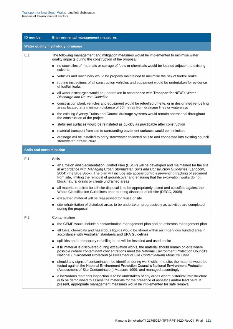
Parsons Brinckerhoff | 2176502A-TPT-RPT-7620-RevC | Final 121
Transport for New South Wales Lindfield Substation Review of Environmental Factors
ID number Environmental management measures
Water quality, hydrology, drainage
E.1 The following management and mitigation measures would be implemented to minimise water quality impacts during the construction of the proposal:
no stockpiles of materials or storage of fuels or chemicals would be located adjacent to existing culverts
vehicles and machinery would be properly maintained to minimise the risk of fuel/oil leaks
routine inspections of all construction vehicles and equipment would be undertaken for evidence of fuel/oil leaks
all water discharges would be undertaken in accordance with Transport for NSW’s Water Discharge and Re-use Guideline
construction plant, vehicles and equipment would be refuelled off-site, or in designated re-fuelling areas located at a minimum distance of 50 metres from drainage lines or waterways
the existing Sydney Trains and Council drainage systems would remain operational throughout the construction of the project
stabilised surfaces would be reinstated as quickly as practicable after construction
material transport from site to surrounding pavement surfaces would be minimised
drainage will be installed to carry stormwater collected on site and connected into existing council stormwater infrastructure.
Soils and contamination
F.1 Soils
an Erosion and Sedimentation Control Plan (ESCP) will be developed and maintained for the site in accordance with Managing Urban Stormwater, Soils and Construction Guidelines (Landcom, 2004) (the Blue Book). The plan will include site access controls preventing tracking of sediment from site, limiting the removal of groundcover and ensuring that the excavation works do not block natural drains or create undrained areas
all material required for off-site disposal is to be appropriately tested and classified against the Waste Classification Guidelines prior to being disposed of off-site (DECC, 2008)
excavated material will be reassessed for reuse onsite
site rehabilitation of disturbed areas to be undertaken progressively as activities are completed during the proposal.
F.2 Contamination
the CEMP would include a contamination management plan and an asbestos management plan
all fuels, chemicals and hazardous liquids would be stored within an impervious bunded area in accordance with Australian standards and EPA Guidelines
spill kits and a temporary refuelling bund will be installed and used onsite
if fill material is discovered during excavation works, the material should remain on-site where possible (where contaminant concentrations meet the National Environment Protection Council’s National Environment Protection (Assessment of Site Contamination) Measure 1999
should any signs of contamination be identified during work within the site, the material would be tested against the National Environment Protection Council’s National Environment Protection (Assessment of Site Contamination) Measure 1999, and managed accordingly
a hazardous materials inspection is to be undertaken of any areas where historical infrastructure is to be demolished to assess the materials for the presence of asbestos and/or lead paint. If present, appropriate management measures would be implemented for safe removal

122 Parsons Brinckerhoff | 2176502A-TPT-RPT-7620-RevC | Final
Transport for New South Wales Lindfield Substation Review of Environmental Factors
ID number Environmental management measures
soil excavated in areas with identified surrounding industrial land uses (including former uses) is to be assessed for either its potential re-use on-site or classified for waste disposal purposes. If groundwater is encountered during the works, groundwater quality is to be investigated and appropriate management measures implemented to avoid further impacts
procedures for handling asbestos contaminated materials (if found on site), including record keeping, site personnel awareness and waste disposal would be undertaken in accordance with WorkCover requirements.
Non-Indigenous heritage
G.1 Care should be taken to make the substation building as unobtrusive as possible. This can be achieved by completing the roofing and walls in dark colours, sympathetic to the surrounding area.
The lower the substation is in the landscape, the less visual impact it would have on the heritage conservation area, and the surrounding Lindfield area.
Consideration should be given toward introducing screening vegetation along the southern boundary of the proposed substation site at the completion of works.
Aboriginal heritage
H.1 If suspected Aboriginal objects are located during construction, an archaeologist would be notified to assess the nature and significance of the find. If the find is and Aboriginal object, further investigation and permits may be required before works commence. If the find is an Aboriginal object OEH and the MLALC would be notified.
H.2 If suspected human skeletal remains were uncovered at any time within the study area, the following actions would need to be followed:
immediately cease all excavation activity in the vicinity of the remains
notify NSW Police
notify OEH via the Environment Line on 131 555 to provide details of the remains and their location
no recommencement of activity in the vicinity of the remains unless authorised in writing by OEH.
Waste and resource management
I.1 The following key waste mitigation and management strategies would be implemented throughout the construction of the proposal and would be governed by the CEMP:
where possible, construction wastes would be diverted from landfill and reused or recycled within the proposal areas or through an appropriate recycling contractor
construction materials that contain minimal embodied energy would be utilised
construction materials would be purchased in accordance with an established procurement strategy that prioritises the selection of materials that utilise best practice recycled material content and sustainability ratings
site disturbance and unnecessary excavation would be minimised
materials from any demolition works would be reused or recycled where practicable
formwork would be reused where possible
sewage waste would be disposed of by a licensed waste contractor in accordance with Sydney Water and OEH requirements.

Parsons Brinckerhoff | 2176502A-TPT-RPT-7620-RevC | Final 123
Transport for New South Wales Lindfield Substation Review of Environmental Factors
ID number Environmental management measures
Air quality
J.1 The following mitigation measures are recommended during the construction phase of works and should be considered for inclusion within the CEMP:
dust minimisation measures would be developed and implemented prior to commencement of construction
methods for management of emissions would be incorporated into proposal inductions, training and pre-start talks
activities with the potential to cause significant emissions such as earthworks or track removal would be identified in the CEMP. Work practices which minimise emissions during these activities should be investigated and applied where reasonable and feasible
during bulk earthworks, visual inspection for dust in periods of unfavourable meteorological conditions (such as high wind events and dry weather) would be undertaken and where necessary the following measures would be implemented:
apply water (or alternative measures) to exposed surfaces that are causing dust generation. Surfaces may include any exposed surfaces (for example recently scraped/graded areas)
apply water to works related to removal of redundant equipment. Application rates should be related to atmospheric conditions (e.g. prolonged dry periods)
dust-generating activities (particularly clearing and excavating) should be avoided or minimised during dry and windy conditions
a mechanism for responding to complaints from the community would be put in place for the duration of the construction phase
construction plant and equipment would be well maintained and regularly serviced so that vehicular emissions remain within relevant air quality guidelines and standards
emissions from trucks and other heavy vehicles would be regulated in accordance with the requirements prescribed in the National Environment Protection Measure (NEPM) (Diesel Vehicle Emissions)
all construction vehicles would be ensured to be tuned to not release excessive level of smoke from the exhaust and are compliant with OEH’s Smokey Vehicles Program under the POEO Act and (NSW) Protection of the Environment and Operations Regulations 2010
strategies would be put in place to reduce usage of chemical and fuels in additional to using alternative fuel technologies as recommended in the NSW Action for Air (NSW EPA 2009). Particular focus would be on those products with the potential to release high levels of air toxics
during operation of the substation site, ancillary service vehicles and maintenance equipment would be maintained and operated in accordance with the manufacturer’s requirements and the POEO Act.
Greenhouse gasses
K.1 While it would not be possible to completely mitigate the generation of greenhouse gas emissions during construction (due to the need to consume energy and resources), the amount of emissions could be reduced by implementing the following mitigation measures:
purchasing electrical energy derived from a renewable energy source (where available)
using low greenhouse gas-intensive construction materials (where a suitable substitute for a high greenhouse gas-intensive material is available)
adopting energy efficient work practices
identifying measures for mitigation as part of site inductions, training and pre-start talks
procuring construction services and materials locally to minimise the distance travelled and therefore emissions of vehicles accessing the site
ensuring that deliveries are managed in an efficient manner to minimise the number of trips required and therefore reduce the amount of emissions

124 Parsons Brinckerhoff | 2176502A-TPT-RPT-7620-RevC | Final
Transport for New South Wales Lindfield Substation Review of Environmental Factors
ID number Environmental management measures
implementing energy-efficient work practices, such as switching off construction plant, vehicles and equipment when not in use to minimise idling
regularly monitoring, auditing and reporting on energy, resource use and associated greenhouse gas emissions as part of the environmental reporting requirements specified within the CEMP
selecting materials during construction planning to ensure products that reduce embodied carbon are considered and used
ensuring clearance of vegetation be limited to the minimum that is required for the project
ensuring all vegetation cleared be disposed of at a registered compost facility in the Sydney area and that it is not to be sent to landfill or burnt.
7.2.2 Operational management
Environmental management measures to be implemented during the operation of the traction substation at
Lindfield are listed in Table 7.2.
Table 7.2 Operational environmental management measures
ID number Safeguard/management measure
Landscape and visual character
L.1 Materials and finishes
To ensure high quality materials and finishes are achieved on the building and fence, the proposed materials and finishes to be used would be clarified as part of the detailed design. Any outside attachments to the buildings, such as services, air conditioning units or vents would also be of a similar high quality and positioned to be as obtrusive as possible, and screened as necessary.
L.2 Landscape design
One of the most positive visual mitigation measures would be the proposed landscape planting that would partially screen the outer sides of the building from views from surrounding areas. At this stage, the final design of such landscape planting has not been finalised. . However, the planting must have the following attributes:
ensure partial screening occurs whilst still considering aspects such as personal safety for users of the adjacent footpaths and not creating concealment opportunities or the potential for planting to encroach onto the footpath
use of trees and shrubs ranging up to two metres when near the footpath
local native plants should be selected as far as practical
planting densities of lower storey plants should be a minimal of one per square metre to assist in the management of weeds
all landscape planting should be in fully prepared, mulched planting beds, and at least half of the pot sizes planted should be of 200 millimetre size or greater, and trees planted at 10 litre pot sizes as a minimum.
Noise and vibration
M.1 The substation would be designed and operated to comply with the Industrial Noise Policy.

Parsons Brinckerhoff | 2176502A-TPT-RPT-7620-RevC | Final 125
Transport for New South Wales Lindfield Substation Review of Environmental Factors
8. Justification and conclusion
8.1 Justification for the proposal
This REF seeks to assess the environmental impacts of the construction and operation of a traction
substation and associated cabling relocation works at Lindfield (‘the proposal’).
In future, Sydney Trains intends to operate increasing train services on the North Shore Line. A new traction
power substation is required to allow for an increase in the capacity along the North Shore Line for additional
train services to be run and will support the delivery of the NWRL. Therefore, a new substation is proposed
to be constructed at Lindfield to supply the North Shore Line.
8.2 Ecologically sustainable development considerations
Ecologically sustainable development (ESD) is development that improves the total quality of life, both now
and in the future in a way that maintains the ecological processes on which life depends. The principles of
ESD have been an integral consideration for the proposal. This includes the effective integration of economic
and environmental considerations in all decision-making processes.
In accordance with the (NSW) Environmental Planning and Assessment Regulation 2000, the four principles
of ESD, as set out in Schedule 2, are:
precautionary principle — Where there are threats of serious or irreversible environmental damage, lack
of full scientific certainty should not be used as a reason for not implementing mitigation measures or
strategies to avoid potential impacts
inter-generational equity — The present generation should ensure that the health, diversity and
productivity of the environment are equal to or better for the future generations
conservation of biological diversity and ecological integrity — Preserving biological diversity and
ecological integrity requires that ecosystems, species and genetic diversity within species are
maintained
improved valuation and pricing of environmental resources — This principle establishes the need to
determine economic values for services provided by the natural environment, such as the atmosphere’s
ability to receive gaseous emissions, cultural values and visual amenity.
Transport for NSW is committed to ensuring that its activities are undertaken in a manner that is consistent
with the four principles of ESD. These principles would be incorporated into Transport for NSW’s
management systems for the proposal (discussed previously in Chapter 7).
Table 8.1 summarises how the four principles of ESD have been addressed through the proposal design and
assessment processes.

126 Parsons Brinckerhoff | 2176502A-TPT-RPT-7620-RevC | Final
Transport for New South Wales Lindfield Substation Review of Environmental Factors
Table 8.1 Adherence with the principles of ESD
ESD principle Adherence
Precautionary principle A precautionary approach has been applied throughout the proposal’s development.
The options development and assessment, the design development and the REF process have sought to minimise the environmental impact of the proposal. There are no threats of serious or irreversible damage posed by this development. All of the environmental risks have been carefully and thoughtfully considered through the preparation of the REF and would be mitigated through the implementation of the Construction Environmental Management Plan (CEMP) for the proposal.
Intergenerational equity This proposal would help to ensure that future generations have a safer, more comfortable and more reliable rail transport option, through increased reliability, and more frequent services.
Additionally, the proposal would help to meet the needs of an increasing population size and potentially reduce the use of private vehicles.
Conservation of biological diversity and ecological integrity
A specialist biodiversity assessment was completed as part of this REF, as described in section 6.4.
Due to the generally disturbed nature of the proposal site, no biodiversity of ecological significance is anticipated to be encountered. However, the adherence to the mitigation measures outlined in this REF would help to ensure that biological diversity and ecological integrity of receiving environments would be retained.
Improved valuation and pricing of environmental resources
Environmental and social issues were considered in the strategic planning and establishment of the need for the proposal, and in consideration of various proposal options. The value placed on environmental resources is evident in the extent of the planning, environmental investigations and design of proposal safeguards. Implementation of these mitigation measures would result in an economic cost to Transport for NSW.
Mitigation measures for the avoidance, reuse, recycling and management of waste during construction and operation are to be implemented.
8.3 Clause 228 considerations
Clause 228 of the NSW Environmental Planning and Assessment Regulation 2000 (EP&A Regulation) states
factors that must be taken into account when assessing the impact of an activity on the environment.
Table 8.2 provides a summary checklist of matters that must be considered under Clause 228 of the EP&A
Regulation.
Table 8.2 Clause 228 considerations
Clause 228 considerations Impact
a Any environmental impact on a community
Some impacts on the local community are anticipated during the construction of the proposal, including minor traffic and parking impacts.
Some operational visual impacts are expected from the proposed substation at Lindfield including the visual impact of the new substation structure and removal of some of the existing vegetation on the proposal site.
In terms of noise, whilst exceedances have been predicted, it is expected that the substation can be readily designed to meet the noise goals through provision of shielding or upgrading the acoustic performance of the enclosure. Past experience of measurements of similar substations indicates that the major noise source which requires specific attention is the rectifier transformer.
Short-term negative impacts during the construction period
Minor negative impact

Parsons Brinckerhoff | 2176502A-TPT-RPT-7620-RevC | Final 127
Transport for New South Wales Lindfield Substation Review of Environmental Factors
Clause 228 considerations Impact
Mitigation and management measures would be implemented to manage and minimise any adverse impacts (refer Chapter 7). The long-term benefits of maintaining the required traction power supply to the North Shore Line are considered to outweigh the potential negative impacts associated with the proposal.
b Any transformation of a locality
The proposed substation at Lindfield is expected to have some visual amenity impacts on the surrounding locality due to the removal of some existing vegetation and construction of the new substation building. The proposal is not however anticipated to result in a substantial transformation of the locality.
Long-term (permanent vegetation removal) minor negative impacts
c Any environmental impact on the ecosystems of the locality
A biodiversity assessment was undertaken for the proposal, as described in Section 6.4 and Technical Paper 4. Vegetation of ecological significance recorded in the study area included the Sydney Turpentine Ironbark Forest threatened ecological community (0.05 hectares) listed as endangered under the NSW Threatened Species Conservation Act 1995. This community within the study area was highly modified as a result of previous land clearing and invasion of weed species. As a result of its low condition this community did not meet the Commonwealth condition criteria for the critically endangered Sydney Turpentine Ironbark Forest of the Sydney Basin as listed under the Commonwealth Environment Protection Biodiversity Conservation Act 1999 listed. Based on the small area of degraded habitat to be impacted, this species is unlikely to be significantly affected by the proposal. Overall, the potential impact from the proposal on the species is not considered significant with regard to its context and intensity.
The study area contained some native plant species however was dominated by a variety of introduced species, the most dominant of which included Privet species (Ligustrum spp*), Camphor Laurel (Cinnamomum camphora*), Asparagus Fern (Asparagus aethiopicus*), Wandering Jew (Tradescantia albiflora*) and Chilean Needle Grass (Nassella neesiana*).
No threatened species or populations of plant were recorded during vegetation surveys of the study area. No threatened species of animals were recorded. However, fauna survey was limited to day-active species and habitat assessment which was undertaken from the roadside. Vegetation within the study area was of low conservation importance as it provided potential habitat only for species that are adapted to disturbed urban landscapes such as bats and birds. This habitat does provide marginal habitat for a number of threatened animal species such as Powerful Owl and a variety of bats.
The vegetation within the study area adjoins the rail corridor and local arterial roads which heavily fragment the vegetation within the study area. As a result, the vegetation within the study area is isolated and only connects to planted street trees. Although there are only small patches of vegetation within the study area it plays a minor role in maintaining local connectivity between larger remaining patches of habitat in the broader locality. These linkages may be used by highly mobile species (such as bats and birds).
The proposal is likely to have minor impacts on biodiversity. Assessments of significance were conducted on threatened species considered likely to occur within the study area. If mitigation measures, as outlined in this report, are implemented it is unlikely that the proposal will have significant impacts on threatened species or ecological communities.
Long-term (permanent vegetation removal) minor negative impact

128 Parsons Brinckerhoff | 2176502A-TPT-RPT-7620-RevC | Final
Transport for New South Wales Lindfield Substation Review of Environmental Factors
Clause 228 considerations Impact
d Any reduction of the aesthetic, recreational, scientific or other environmental quality or value of a locality
The proposal is expected to have some ecological and visual impacts on the proposal area, as outlined in Sections (a) to (c) above.
The design of the proposed substation building is not anticipated to result in the reduction of the aesthetic, recreational, scientific or other environmental quality or value of the locality.
Long-term (permanent vegetation removal) minor negative impact
e Any effect on a locality, place or building having aesthetic, anthropological, archaeological, architectural, cultural, historical, scientific or social significance or other special value for present or future generations
The proposal would not have an effect on a locality, place or building of significance or other special value for present or future generations. There would be no impact to any listed heritage items.
No impacts
f Any impact on the habitat of protected fauna (within the meaning of the National Parks and Wildlife Act 1974)
No protected fauna habitat (within the meaning of the National Parks and Wildlife Act 1974) was identified within the proposal site.
No impacts
g Any endangering of any species of animal, plant or other form of life, whether living on land, in water or in the air
Impacts on biodiversity are discussed in Section 6.4, Technical Paper 4 and summarised above in Section (c) of this table.
The proposal is likely to have some impacts on biodiversity within the proposal site. Assessments of significance were conducted on threatened species considered likely to occur within the study area. If mitigation measures, as outlined in this report, are implemented it is unlikely that the proposal will have significant impacts on threatened species or ecological communities.
Long-term (permanent vegetation removal) negative impact
h Any long-term effects on the environment
Environmental impact assessments are discussed in Chapter 6 and the attached Technical Papers. Most environmental impacts resulting from the proposal would occur during the construction phase and therefore cause short-term effects on the environment.
As discussed in Section 6.4, Technical Paper 4 and summarised above in Section (c) of this table, some permanent, long-term effects on the environment will result from the proposed vegetation clearing at the site. The biodiversity assessment however confirmed that the proposal is likely to have some impacts on biodiversity within the proposal site.
The design of the proposed substation building is also not anticipated to result in any substantial negative visual impacts on the existing, urban environment.
Short-term negative impacts
Long-term negative impacts (typically associated with vegetation clearance)
i Any degradation of the quality of the environment
There is potential for contaminated land to be encountered and exposed during the construction of the substation at (refer Section 6.7 of this REF). Management measures have been proposed to minimise risks associated with these potential impacts during excavation and construction on the site.
It is considered that should these impacts occur during construction of the substation, any potential adverse environmental impacts would be generally localised in nature.
Short-term negative impacts
j Any risk to the safety of the environment
A CEMP would be prepared to cover all construction activities. Management measures have been proposed in Chapter 7 to minimise the risks associated with encountering contaminated land and other potential safety considerations.
No impacts
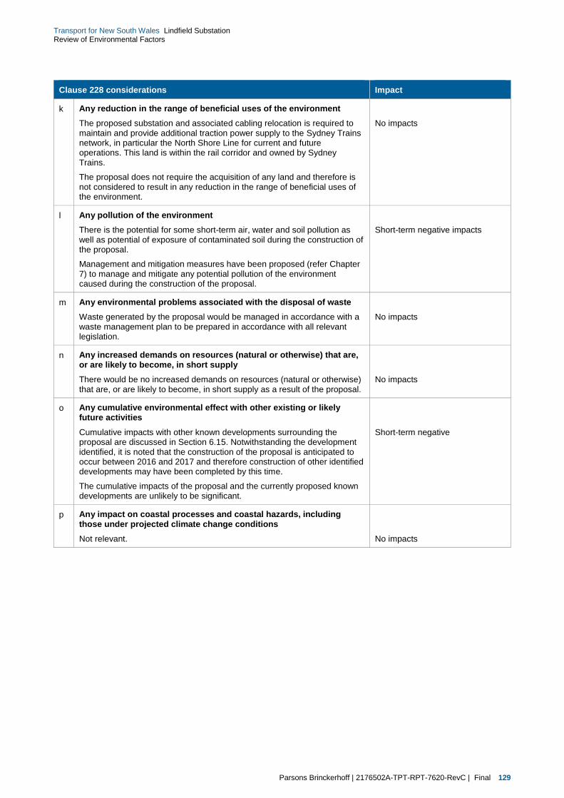
Parsons Brinckerhoff | 2176502A-TPT-RPT-7620-RevC | Final 129
Transport for New South Wales Lindfield Substation Review of Environmental Factors
Clause 228 considerations Impact
k Any reduction in the range of beneficial uses of the environment
The proposed substation and associated cabling relocation is required to maintain and provide additional traction power supply to the Sydney Trains network, in particular the North Shore Line for current and future operations. This land is within the rail corridor and owned by Sydney Trains.
The proposal does not require the acquisition of any land and therefore is not considered to result in any reduction in the range of beneficial uses of the environment.
No impacts
l Any pollution of the environment
There is the potential for some short-term air, water and soil pollution as well as potential of exposure of contaminated soil during the construction of the proposal.
Management and mitigation measures have been proposed (refer Chapter 7) to manage and mitigate any potential pollution of the environment caused during the construction of the proposal.
Short-term negative impacts
m Any environmental problems associated with the disposal of waste
Waste generated by the proposal would be managed in accordance with a waste management plan to be prepared in accordance with all relevant legislation.
No impacts
n Any increased demands on resources (natural or otherwise) that are, or are likely to become, in short supply
There would be no increased demands on resources (natural or otherwise) that are, or are likely to become, in short supply as a result of the proposal.
No impacts
o Any cumulative environmental effect with other existing or likely future activities
Cumulative impacts with other known developments surrounding the proposal are discussed in Section 6.15. Notwithstanding the development identified, it is noted that the construction of the proposal is anticipated to occur between 2016 and 2017 and therefore construction of other identified developments may have been completed by this time.
The cumulative impacts of the proposal and the currently proposed known developments are unlikely to be significant.
Short-term negative
p Any impact on coastal processes and coastal hazards, including those under projected climate change conditions
Not relevant.
No impacts

130 Parsons Brinckerhoff | 2176502A-TPT-RPT-7620-RevC | Final
Transport for New South Wales Lindfield Substation Review of Environmental Factors
8.4 Consideration of matters of national environmental significance
Table 8.3 provides a summary checklist of matters of national environmental significance that were
considered for the proposal under the Commonwealth Environment Protection and Biodiversity Conservation
Act 1999.
Table 8.3 Checklist of EPBC Act matters
Matters of national environmental significance Impact
World heritage properties
There are no items within the proposal area listed on the World Heritage List.
No impacts
National heritage places
There are no items within the proposal area listed on the National Heritage List.
No impacts
Wetlands of international importance
There are no wetlands of international importance in the proposal site or likely to be affected by the proposal.
No impacts
Nationally threatened species and ecological communities
A biodiversity assessment was undertaken for the proposal site, as described in section 6.4 and Technical Paper 4.
Vegetation of ecological significance recorded in the study area included the Sydney Turpentine Ironbark Forest threatened ecological community (0.05 hectares) listed as endangered under the NSW Threatened Species Conservation Act 1995.
This community within the study area was highly modified as a result of previous land clearing and invasion of weed species. As a result of its low condition, this community did not meet the Commonwealth condition criteria for the critically endangered Sydney Turpentine Ironbark Forest of the Sydney Basin as listed under the Commonwealth Environment Protection Biodiversity Conservation Act 1999 listed.
No impacts
Migratory species
Migratory species are protected under international agreements to which Australia are a signatory, including the Japan Australia Migratory Bird Agreement (JAMBA), the China Australia Migratory Bird Agreement (CAMBA), the Republic of Korea Australia Migratory Bird Agreement (RoKAMBA) and the Bonn Convention on the Conservation of Migratory Species of Wild Animals.
A biodiversity assessment was undertaken for the proposal site, as described in section 6.4 and Technical Paper 4. Based on the findings of the desk-top assessment, a total of 33 Migratory species have been recorded or have the potential to occur in the study area locality. Although no Migratory species were recorded during field surveys, the site does contain potential habitat however for the White-throated Needletail.
While terrestrial Migratory species of bird may potentially use the area, the site would not be classed as ‘important habitat’ as defined EPBC Act Policy Statement 1.1 Significant Impact Guidelines as the site does not contain:
habitat utilised by a migratory species occasionally or periodically within a region that supports an ecologically significant proportion of the population of the species
habitat utilised by a migratory species which is at the limit of the species range
habitat within an area where the species is declining.
As such, it is not likely that the proposed activity would significantly affect Migratory species.
No impacts

Parsons Brinckerhoff | 2176502A-TPT-RPT-7620-RevC | Final 131
Transport for New South Wales Lindfield Substation Review of Environmental Factors
Matters of national environmental significance Impact
Commonwealth marine areas
Not relevant to the proposal.
No impacts
The Great Barrier Reef Marine Park
Not relevant to the proposal.
No impacts
Nuclear actions (including uranium mining)
Not relevant to the proposal.
No impacts
A water resource, in relation to coal seam gas development and large coal mining development
Not relevant to the proposal.
No impacts
8.5 Significance of the environmental impacts
The potential impacts of the proposal have been considered in accordance with the requirements of
Section 111 of the EP&A Act, Clause 228 of the EP&A Regulation and the EPBC Act. Whilst some
potentially negative impacts may result from the proposal, these impacts are not considered to be significant,
as discussed in Chapter 6 of this REF. Chapter 7 of this REF provides mitigation measures and
management strategies that would be implemented to reduce potentially negative impacts and manage
environmental impacts.
8.6 Conclusion
The NSW Government has developed a plan to transform and modernise Sydney’s rail network so that it can
grow with the city’s population and meet the needs of customers into the future. The NSW Government has
identified that Sydney’s rail system is reaching the limits of its capacity. For example, at present there are
parts of the network where 20 trains are scheduled to run in the busiest peak hour but often only 17 trains
actually arrive during that period (NSW Government 2012b).
In future, Sydney Trains intends to operate increasing train services on the North Shore Line. A new traction
power substation is required to allow for an increase in the capacity along the North Shore Line for additional
train services to be run and will support the delivery of the NWRL. Therefore, a new substation is proposed
to be constructed at Lindfield to supply the North Shore Line.
Notwithstanding the above benefits, the proposal would result in some adverse environmental impacts during
construction and operation of the proposed substation. The key potential impacts associated with the
proposal would likely comprise:
Vegetation removal — construction of the proposed substation and associated cabling at Lindfield
would require the removal of up to approximately 0.94 hectares of native vegetation being a
combination of Blue Gum High Forest and Sydney Turpentine Ironbark Forest scrubby regrowth.
Up to approximately 2.31 hectares of habitat would be removed which is of low to moderate condition
and may provide some marginal foraging habitat for several threatened species of birds and bats.
Significance assessments have been undertaken for threatened biodiversity which have concluded that
due to the small area and highly modified condition of the vegetation and habitat recorded within the
study area, the proposed substation construction is not likely to have a significant impact on any
threatened biodiversity, nor would it interfere with their recovery, assuming appropriate mitigation
measures are implemented.

132 Parsons Brinckerhoff | 2176502A-TPT-RPT-7620-RevC | Final
Transport for New South Wales Lindfield Substation Review of Environmental Factors
Based on the assumption that the ‘additional aerial earth (overhead) wires only’ section of the proposed
will require the removal of vegetation to the north of Lindfield Station construction of the proposed
substation at Lindfield will require the removal of 2.31 hectares of potential foraging habitat for these
species. In the likelihood that power poles are not replaced as part of the proposed this area of
vegetation removed will be reduced. However, if required, offsetting would be undertaken in alignment
with Transport for NSW offsetting guidelines (Transport for NSW, 2014) during detailed design.
Construction noise — the proposal would result in construction noise and vibration impacts within the
local area at a range of residential receivers during specific activities. There may be some short-term
exceedances of the construction noise criteria (including the use of rock breaking equipment and the
placement of plant and equipment) in addition to during out-of-hours works. These exceedances are
expected to be short-term in duration and all feasible and reasonable practices would be applied to
minimise noise impacts to the local community during these periods. In the event of the need for out-of-
hours works, the contractor would be required to discuss the proposed works with the EPA and notify
local residents and businesses prior to the proposed works occurring. Mitigation measures put in place
during construction would reduce the predicted noise levels to within an acceptable range.
Operational noise – some noise impacts may occur to sensitive receivers adjacent to the proposal site.
The predicted base case steady state noise levels have been identified as resulting in a worst-case
11 dB exceedance of the night-time intrusive goal at the nearest sensitive receivers (without mitigation).
The predicted LA1(60second) noise levels also exceed the sleep disturbance goals at the nearest residential
receiver locations by up to 16 dB. It should be noted, however, that the predicted noise level from circuit
breaker operation will not occur on a continuous basis and will likely be a very infrequent occurrence
during the night-time period – potentially once or twice a month.
Whilst this exceedance has been predicted to be moderate, it is expected that the substation can be
readily designed (during the detailed design stage of the proposal) to meet the noise goals through
provision of shielding or consideration of the acoustic performance of the enclosure during detailed
design of the structure. Mitigation measures would be put in place to reduce the predicted noise levels
to within an acceptable range during operation of the substation.
Visual – the landscape and visual impacts would generally be restricted to a small number of localised
viewing locations to the site as a result of the introduction of a new structure and the removal of some
existing screening. This potentially increases the visibility of the substation and existing train
movements along the rail corridor. Some improvement to the existing visual landscape would occur as a
result of the removal of overhead wiring generally between power pole P57 (south of Lindfield Station
near Russell Avenue) and power pole P49 (north of the Clanville Road overbridge). Landscape and
visual impacts would occur during both the construction and operational phases. However, the
proposed landscape planting would partially screen the outer sides of the building from views from the
surrounding areas.
Construction traffic — some limited traffic impacts may occur during the construction of the proposed
substation and associated cabling, including some increase in heavy vehicle movements and the
potential for limited road closures during the delivery of primary equipment such as transformer and
reactor units.
Notwithstanding the above impacts, it is considered that the adverse environmental impacts are generally
localised in nature. With the implementation of the proposed mitigation and management measures specified
in Chapter 7, the potential environmental impacts of the proposal could be adequately mitigated and
managed, and are not considered to be significant.

Parsons Brinckerhoff | 2176502A-TPT-RPT-7620-RevC | Final 133
Transport for New South Wales Lindfield Substation Review of Environmental Factors
9. References
Australian Weeds Committee 2013, Weeds of National Significance, viewed 2/12/2013 2013,
<http://www.weeds.org.au/WoNS/>
Department of Environment and Conservation, (DEC) 2006, Assessing Vibration – a technical guideline
Department of Environment Climate Change (DECC) 2008, Waste Classification Guidelines prior to being
disposed of off-site
Department of Environment Climate Change (DECC) 2009, Interim Construction Noise Guideline
Department of Environment Climate Change and Water (DECCW) 2011, Road Noise Policy
Department of Environment and Heritage 1992, National Strategy for Ecologically Sustainable Development
Department of Urban Affairs & Planning 1996, NSW Heritage Manual
Environment Protection Agency 1999, NSW Action for Air
Environment Protection Agency 2000, NSW Industrial Noise Policy
Infrastructure NSW 2012, State Infrastructure Strategy
Landcom 2004, Managing Urban Stormwater, Soils and Construction Guidelines
NSW Government 2010a, NSW State Plan – Investing in a Better Future, March 2010
NSW Government 2010b, Metropolitan Plan for Sydney 2036
NSW Government 2011, NSW 2021: A Plan to Make NSW Number One, September 2011
NSW Government 2012a, NSW Long Term Transport Master Plan, December 2012
NSW Government 2012b, Sydney’s Rail Future Modernising Sydney’s Trains, June 2012
NSW Government 2013a, Draft Metropolitan Strategy for Sydney 2031
NSW Government 2013b, North Ryde Station Precinct Development Control Plan
NSW Office of Environment and Heritage (OEH) 2010, Code of Practice for Archaeological Investigation of
Aboriginal Objects in New South Wales
Parsons Brinckerhoff 2014, Epping to Chatswood Rail Link – Alternative Transport Assessment: Volume 1
and Volume 2
Roads and Maritime Services 2013, Environmental Impact Assessment Practice Note - Guideline for
Landscape Character and Visual Impact Assessment and the

134 Parsons Brinckerhoff | 2176502A-TPT-RPT-7620-RevC | Final
Transport for New South Wales Lindfield Substation Review of Environmental Factors
Tozer, M 2003, 'The native vegetation of the Cumberland Plain, western Sydney: systematic classification
and field identification of communities', Cunninghamia, vol. 8, no. 1, pp. 1-75
Transport for NSW 2012, NSW Sustainable Design Guidelines for Rail
Transport for NSW 2014, Vegetation Offset Guide
United Kingdom’s 2013, Landscape Institute and the Institute of Environmental Management and
Assessment