Embed Size (px)
Citation preview
Western Lost City Access Track
Limmen National Park
This is a guide to help you reach the Western Lost City, a spectacular sandstone feature of the Park. Each of the points of interest below refer to the numbers on the map overleaf.
Zero your trip metre at the entrance gate, remember to keep the gate locked and to sign in and out of the logbook located by the gate. The Lost City is approximately 28 km along this track. Your return is via the same track, so beware of other vehicles. This track is rough in places and you should take extreme care. Travel time approximately 1.5 hours each way.
* Please drive only on the maintrack, do not follow other wheeltracks as these are used by Parkstaff while performing their dutiesand may lead to areas where youcould become lost.
1 2.2 km
This is the first of many rocky creeks you will cross on your trip to the Lost City, the dense vegetation on the creek’s banks is home to many species of small birds. These include the Red-backed Fairy-wren and even the endangered Purple-crowned Fairy-wren. Look for debris in the trees, this indicates the height of wet season flood waters.
2 4.9 km
You are now crossing the Limmen Bight River; it flows north east for a further 60 km
Parks & Wildlife Commission of the Northern Territory
Limmen Ranger Station Katherine Regional Office Ph: (08) 8975 9940 32 Giles St
PO Box 344, KATHERINE NT 0851 www.parksandwildlife.nt.gov.au Ph: (08) 8973 8888
where the river finally meets the Gulf of Carpentaria. This river can flow all year round, although it is often dry by July / August, depending on the previous wet season.
3 5.4 km
Caution rough creek. Stop and have a look at the large rocks in the base of the creek. These are Stromatolites formed by algae as it grew through deposited sediments on an ancient seabed. They date back as far as 3.5 billion years.
4 14 km
Clear Waterhole - is a permanent waterhole fed by the floodwaters of the Limmen Bight River. Many water birds may be seen here including Pelicans, Jabiru and Brolga.
Swimming is not recommended.
5 17.5 km
From here you will follow a string of water holes to the south. Most dry up by the end of the dry season, but while they last many animals and birds frequent these holes.
6 22 km
Signs of pastoral history are evident here. The open black soil plains once provided good grazing country, as is evident by the old fences. While mustering was relatively easy on the flats, many cattle were lost in the rocky country or along the riverbed during floods.
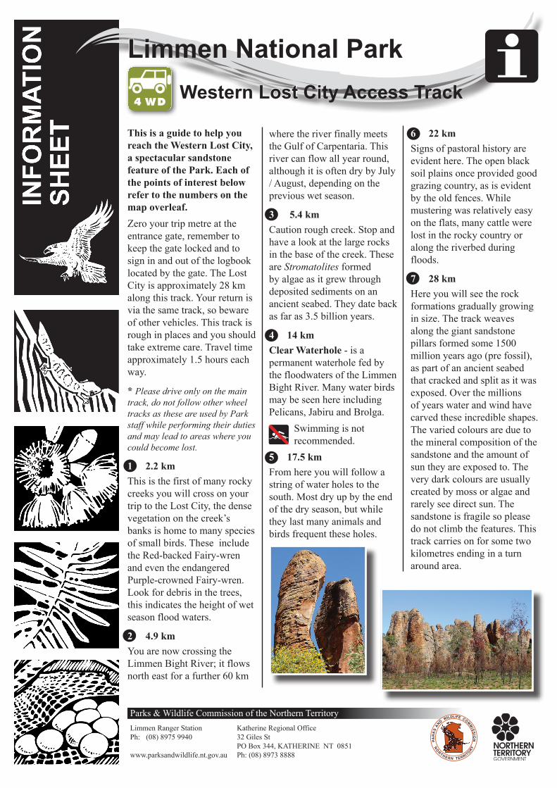
7 28 km
Here you will see the rock formations gradually growing in size. The track weaves along the giant sandstone pillars formed some 1500 million years ago (pre fossil), as part of an ancient seabed that cracked and split as it was exposed. Over the millions of years water and wind have carved these incredible shapes. The varied colours are due to the mineral composition of the sandstone and the amount of sun they are exposed to. The very dark colours are usually created by moss or algae and rarely see direct sun. The sandstone is fragile so please do not climb the features. This track carries on for some two kilometres ending in a turn around area.

Western Lost City Access Track
• Ensure your vehicle is well maintained and equipped.
• Trailers are not recommended on this track and can be left at the Ranger Station.
• Tell someone responsible where you are going and when you expect to be back.
• Carry either a working HF radio, satellite phone or emergency beacon (PLB).
• Carry enough fuel for your entire trip.
• Carry at least two spare tyres • Carry and make sure you can
use a puncture repair kit. • Carry more than enough food
and water for your trip plus extra in case of emergency.
Four Wheel Drive Safety
Q
LEGEND
4WD Track
Unsealed Road
Watercourse
Fenceline
Lost City Formations
Point of Interest
Gate
Map not to scale
• Take all your rubbish away with you
• All cultural items and wildlife are protected
• Avoid using soap or detergents in or near waterways
Please Remember
7
6
5 4
3 2
1
Airstrip
Butterfly Falls
Nathan River Ranger Station
To Roper Bar 190 km
Clear Waterhole
Western Lost City
Lim
men
Bigh
t R
iver
To Borroloola 180 km
* Note that this map is not to scale and should be used as a guide only.
D/07/2017PWCNT Information Sheet For more information see our website: www.parksandwildlife.nt.gov.au or contact Katherine Visitor Information Centre on (08) 8972 2650.