1
LEE AUGUSTA BATH HALIFAX WISE BEDFORD SCOTT FRANKLIN PITTSYLVANIA LOUISA SMYTH WYTHE FAUQUIER ROCKINGHAM ALBEMARLE GILES SUSSEX PATRICK NELSON PAGE FLOYD HENRY BLAND CAROLINE RUSSELL LOUDOUN CRAIG CARROLL TAZEWELL AMHERST FAIRFAX AMELIA HANOVER CAMPBELL DINWIDDIE BRUNSWICK ROCKBRIDGE GRAYSON BUCHANAN BOTETOURT MECKLENBURG SUFFOLK BUCKINGHAM WASHINGTON HIGHLAND SURRY ORANGE CHARLOTTE SOUTHAMPTON PULASKI ESSEX ALLEGHANY FREDERICK SHENANDOAH CULPEPER LUNENBURG MADISON ACCOMACK ROANOKE CHESTERFIELD DICKENSON NOTTOWAY SPOTSYLVANIA FLUVANNA MONTGOMERY HENRICO STAFFORD APPOMATTOX WARREN POWHATAN GOOCHLAND CHESAPEAKE CLARKE GREENSVILLE PRINCE WILLIAM ISLE OF WIGHT CUMBERLAND PRINCE EDWARD KING WILLIAM NEW KENT GREENE KING AND QUEEN RICHMOND RAPPAHANNOCK GLOUCESTER PRINCE GEORGE YORK WESTMORELAND VIRGINIA BEACH KING GEORGE CHARLES CITY LANCASTER JAMES CITY MIDDLESEX NORTHAMPTON NORTHUMBERLAND MATHEWS NORFOLK HAMPTON NEWPORT NEWS PORTSMOUTH POQUOSON WILLIAMSBURG Ohio West Virginia North Carolina Kentucky Maryland Tennessee Delaware Pennsylvania District of Columbia Map prepared by USDA-NRCS Soil Survey Division-National Geospatial Development Center, PO Box 6301, West Virginia University, Morgantown, WV 26506-6301 NGDC-d142-08312009-3 Detailed Soil Survey Atlas - Homeland Security Internal Review Only Limitations for Trench Sanitary Landfills - Virginia (2009) Virginia Sources: ESRI. 1992. 1:3,000,000 Oceans. ArcWorld. ESRI - Redlands, CA. National Atlas (http://www.nationalatlas.gov/). Roads. (09/2005). National Atlas (http://www.nationalatlas.gov/). State Boundaries. (03/2007). USDA-NRCS Staff. 2003. County Boundaries derived from 1:100,000 (Bureau of Census – TIGER) source as provided by C. Lloyd, USDA-NRCS, Information Technology Center, Fort Collins, CO. USDA-NRCS. 2008. ENG - Sanitary Landfill (Trench) Interpretation. Soil Data Mart Source (http://soildatamart.nrcs.usda.gov). Fiscal Year 2009, first quarter edition. USDA-NRCS. 2008. Soil Survey Geographic Database (SSURGO) version 2.1. Virginia Collection. Richmond, VA. Soil Data Mart Source (http://soildatamart.nrcs.usda.gov). Fiscal Year 2009, first quarter edition. USGS. Analytical Hillshade computed from 30 meter National Elevation Dataset (NEDS) using the following parameters: 315 degrees altitude, 45 degrees azimuth, and z factor 1x. Prepared by USDA-NRCS-NGDC, Morgantown, WV. 0 30 60 Kilometers Albers Equal Area Map Projection North American Datum of 1983 Original Map Scale 1:500,000 Original Map Scale is 1:500,000 when printed using a page size of 60"W x 54"H. When printed at other page sizes, the original absolute map scale will no longer be valid and scale bars should be used for reference. 0 15 30 Miles This map was prepared as a general planning aid; on-site soil evaluations may be required prior to making land management decisions. Soils were rated solely on the basis of physical soil properties. Ratings are for soils in their present condition and do not consider current land use. Geographic proximity to watercourses and land use were not considered in this interpretive rating. In cases where multiple soil series are mapped within a given soil delineation (e.g., a map unit complex), the interpretive rating associated with the most common soil series was applied to the entire delineation. Atlantic Ocean Sanitary Landfills (Trench) Sanitary landfill (trench) is a method of disposing solid waste by placing refuse in successive layers in an excavated trench. The waste is spread, compacted, and covered daily with a thin layer of soil that is excavated from the trench. When the trench is full, a final cover of soil material at least 2 feet thick is placed over the landfill. Soils are rated and placed into "Sanitary Landfill (Trench)" interpretive rating classes per their rating indices. These are not limited (rating index = 0), somewhat limited (rating index > 0 and < 1.0), or very limited (rating index = 1.0). Ratings are based on properties and qualities to the depth normally observed during soil mapping (approximately 5 or 6 feet). However, because trenches may be as deep as 15 feet or more, geologic investigations are needed to determine the potential for pollution of ground water as well as to determine the design needed. These investigations include the examination of stratification, rock formations, and geologic conditions that might lead to the conducting of leachates to aquifers, wells, watercourses, and other water sources. Properties that influence the risk of pollution, ease of excavation, trafficability, and revegetation are major considerations. Soils that flood or have a water table within the depth of excavation present a potential pollution hazard and are difficult to excavate. Slope is an important consideration because it affects the work involved in road construction, the performance of the roads, and the control of surface water around the landfill. It may also cause difficulty in constructing trenches for which the trench bottom must be kept level and oriented to follow the contour. The ease with which the trench is dug and with which a soil can be used as daily and final covers is based largely on texture and consistence of the soil. The texture and consistence of a soil determine the degree of workability of the soil both when dry and when wet. Soils that are plastic and sticky when wet are difficult to excavate, grade, or compact and difficult to place as a uniformly thick cover over a layer of refuse. The uppermost part of the final cover should be soil material that is favorable for the growth of plants. It should not contain excess sodium or salt and should not be too acid. In comparison with other horizons, the A horizon in most soils has the best workability and the highest content of organic matter. Thus, for a trench-type landfill operation it may be desirable to stockpile the surface layer for use in the final blanketing of the fill. This interpretation is applicable to both heavily populated and sparsely populated areas. While some general observations may be made, onsite evaluation is required before the final site is selected. Improper site selection, design, or installation may cause contamination of ground water, seepage, and contamination of stream systems from surface drainage or floodwater. Potential contamination may be reduced or eliminated by installing systems designed to overcome or reduce the effects of the limiting soil property.

Limitations for Trench Sanitary Landfills - Virginia (2009)

  • Upload
    others

  • View
    3

  • Download
    0

Embed Size (px)

Citation preview

LEE

AUGUSTA

BATH

HALIFAX

WISE

BEDFORD

SCOTT

FRANKLIN

PITTSYLVANIA

LOUISA

SMYTH

WYTHE

FAUQUIER

ROCKINGHAM

ALBEMARLE

GILES

SUSSEX

PATRICK

NELSON

PAGE

FLOYD

HENRY

BLAND

CAROLINE

RUSSELL

LOUDOUN

CRAIG

CARROLL

TAZEWELL

AMHERST

FAIRFAX

AMELIA

HANOVER

CAMPBELL

DINWIDDIE

BRUNSWICK

ROCKBRIDGE

GRAYSON

BUCHANAN

BOTETOURT

MECKLENBURG

SUFFOLK

BUCKINGHAM

WASHINGTON

HIGHLAND

SURRY

ORANGE

CHARLOTTE

SOUTHAMPTON

PULASKI

ESSEX

ALLEGHANY

FREDERICK

SHENANDOAH

CULPEPER

LUNENBURG

MADISON

ACCOMACK

ROANOKE

CHESTERFIELD

DICKENSON

NOTTOWAY

SPOTSYLVANIA

FLUVANNA

MONTGOMERY

HENRICO

STAFFORD

APPOMATTOX

WARREN

POWHATAN

GOOCHLAND

CHESAPEAKE

CLARKE

GREENSVILLE

PRINCE WILLIAM

ISLE OF WIGHT

CUMBERLAND

PRINCE EDWARD

KING WILLIAM

NEW KENT

GREENE

KING AND QUEEN

RICHMOND

RAPPAHANNOCK

GLOUCESTER

PRINCE GEORGE

YORK

WESTMORELAND

VIRGINIA BEACH

KING GEORGE

CHARLES CITY

LANCASTER

JAMES CITY

MIDDLESEX

NORTHAMPTON

NORTHUMBERLAND

MATHEWS

NORFOLK

HAMPTONNEWPORT NEWS

PORTSMOUTH

POQUOSON

WILLIAMSBURG

Ohio

West Virginia

North Carolina

Kentucky

Maryland

Tennessee

Delaware

Pennsylvania

District of Columbia

Map prepared by USDA-NRCS Soil Survey Division-National Geospatial Development Center, PO Box 6301, West Virginia University, Morgantown, WV 26506-6301 NGDC-d142-08312009-3

Detailed Soil Survey Atlas - Homeland Security Internal Review Only

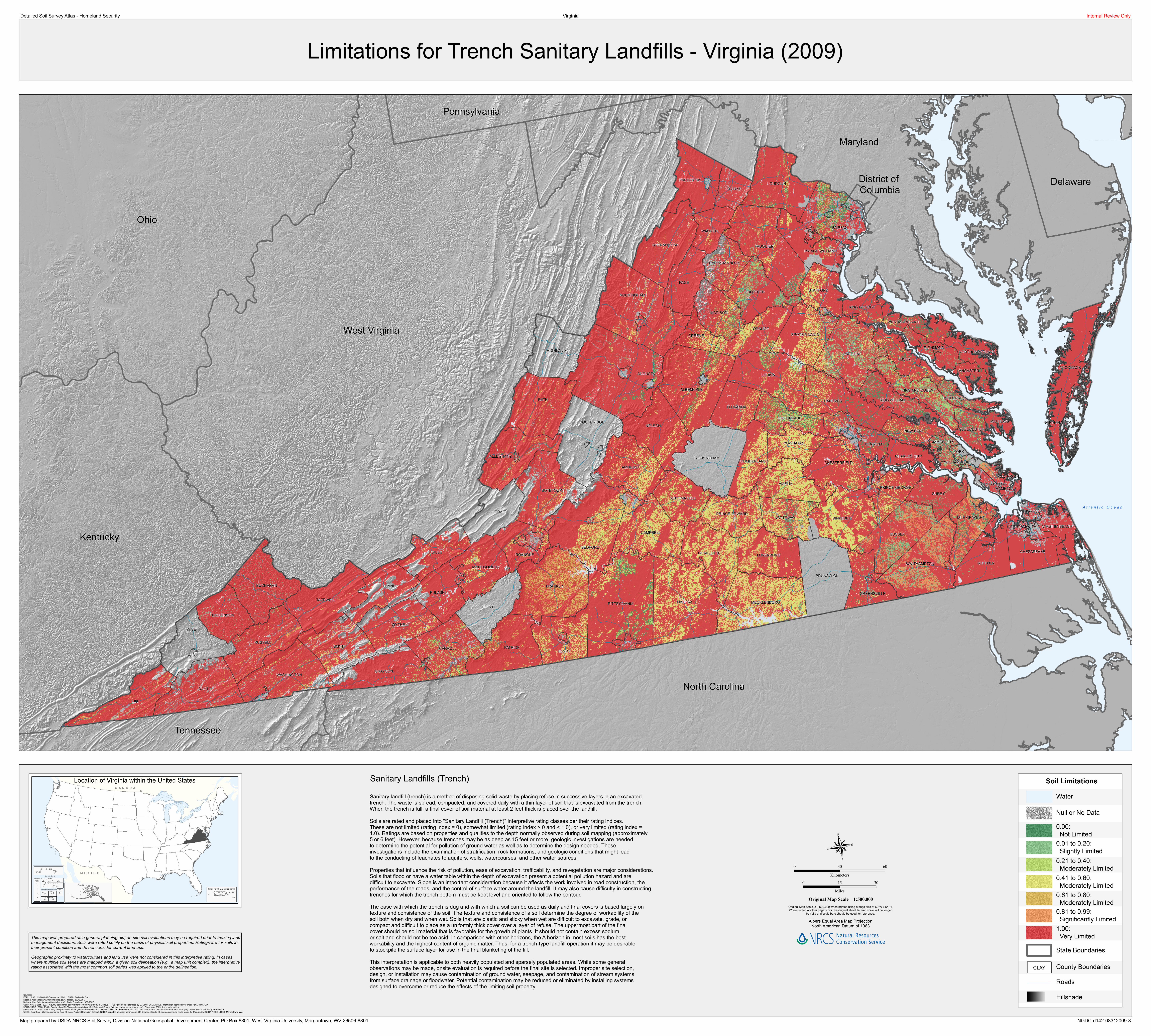
Limitations for Trench Sanitary Landfills - Virginia (2009)Virginia

Sources:ESRI. 1992. 1:3,000,000 Oceans. ArcWorld. ESRI - Redlands, CA.National Atlas (http://www.nationalatlas.gov/). Roads. (09/2005).National Atlas (http://www.nationalatlas.gov/). State Boundaries. (03/2007).USDA-NRCS Staff. 2003. County Boundaries derived from 1:100,000 (Bureau of Census – TIGER) source as provided by C. Lloyd, USDA-NRCS, Information Technology Center, Fort Collins, CO.USDA-NRCS. 2008. ENG - Sanitary Landfill (Trench) Interpretation. Soil Data Mart Source (http://soildatamart.nrcs.usda.gov). Fiscal Year 2009, first quarter edition.USDA-NRCS. 2008. Soil Survey Geographic Database (SSURGO) version 2.1. Virginia Collection. Richmond, VA. Soil Data Mart Source (http://soildatamart.nrcs.usda.gov). Fiscal Year 2009, first quarter edition.USGS. Analytical Hillshade computed from 30 meter National Elevation Dataset (NEDS) using the following parameters: 315 degrees altitude, 45 degrees azimuth, and z factor 1x. Prepared by USDA-NRCS-NGDC, Morgantown, WV.

0 30 60Kilometers

Albers Equal Area Map ProjectionNorth American Datum of 1983

Original Map Scale 1:500,000Original Map Scale is 1:500,000 when printed using a page size of 60"W x 54"H.When printed at other page sizes, the original absolute map scale will no longer

be valid and scale bars should be used for reference.

0 15 30Miles

This map was prepared as a general planning aid; on-site soil evaluations may be required prior to making land management decisions. Soils were rated solely on the basis of physical soil properties. Ratings are for soils intheir present condition and do not consider current land use. Geographic proximity to watercourses and land use were not considered in this interpretive rating. In cases where multiple soil series are mapped within a given soil delineation (e.g., a map unit complex), the interpretiverating associated with the most common soil series was applied to the entire delineation.

A t l a n t i c O c e a n

Sanitary Landfills (Trench)Sanitary landfill (trench) is a method of disposing solid waste by placing refuse in successive layers in an excavatedtrench. The waste is spread, compacted, and covered daily with a thin layer of soil that is excavated from the trench. When the trench is full, a final cover of soil material at least 2 feet thick is placed over the landfill. Soils are rated and placed into "Sanitary Landfill (Trench)" interpretive rating classes per their rating indices. These are not limited (rating index = 0), somewhat limited (rating index > 0 and < 1.0), or very limited (rating index = 1.0). Ratings are based on properties and qualities to the depth normally observed during soil mapping (approximately5 or 6 feet). However, because trenches may be as deep as 15 feet or more, geologic investigations are neededto determine the potential for pollution of ground water as well as to determine the design needed. These investigations include the examination of stratification, rock formations, and geologic conditions that might lead to the conducting of leachates to aquifers, wells, watercourses, and other water sources. Properties that influence the risk of pollution, ease of excavation, trafficability, and revegetation are major considerations.Soils that flood or have a water table within the depth of excavation present a potential pollution hazard and are difficult to excavate. Slope is an important consideration because it affects the work involved in road construction, the performance of the roads, and the control of surface water around the landfill. It may also cause difficulty in constructing trenches for which the trench bottom must be kept level and oriented to follow the contour. The ease with which the trench is dug and with which a soil can be used as daily and final covers is based largely ontexture and consistence of the soil. The texture and consistence of a soil determine the degree of workability of the soil both when dry and when wet. Soils that are plastic and sticky when wet are difficult to excavate, grade, or compact and difficult to place as a uniformly thick cover over a layer of refuse. The uppermost part of the finalcover should be soil material that is favorable for the growth of plants. It should not contain excess sodium or salt and should not be too acid. In comparison with other horizons, the A horizon in most soils has the best workability and the highest content of organic matter. Thus, for a trench-type landfill operation it may be desirable to stockpile the surface layer for use in the final blanketing of the fill.This interpretation is applicable to both heavily populated and sparsely populated areas. While some general observations may be made, onsite evaluation is required before the final site is selected. Improper site selection, design, or installation may cause contamination of ground water, seepage, and contamination of stream systems from surface drainage or floodwater. Potential contamination may be reduced or eliminated by installing systems designed to overcome or reduce the effects of the limiting soil property.