Embed Size (px)
Citation preview
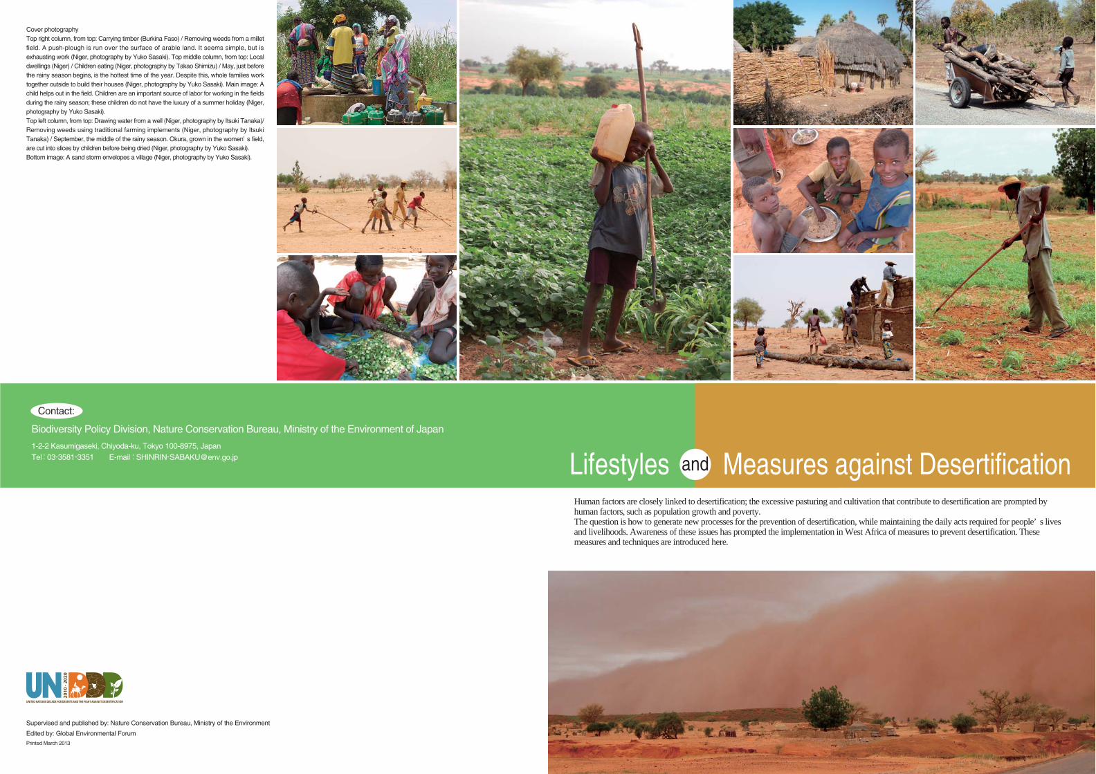
Human factors are closely linked to desertification; the excessive pasturing and cultivation that contribute to desertification are prompted by human factors, such as population growth and poverty. The question is how to generate new processes for the prevention of desertification, while maintaining the daily acts required for people’ s lives and livelihoods. Awareness of these issues has prompted the implementation in West Africa of measures to prevent desertification. These measures and techniques are introduced here.
Cover photographyTop right column, from top: Carrying timber (Burkina Faso) / Removing weeds from a millet field. A push-plough is run over the surface of arable land. It seems simple, but is exhausting work (Niger, photography by Yuko Sasaki). Top middle column, from top: Local dwellings (Niger) / Children eating (Niger, photography by Takao Shimizu) / May, just before the rainy season begins, is the hottest time of the year. Despite this, whole families work together outside to build their houses (Niger, photography by Yuko Sasaki). Main image: A child helps out in the field. Children are an important source of labor for working in the fields during the rainy season; these children do not have the luxury of a summer holiday (Niger, photography by Yuko Sasaki). Top left column, from top: Drawing water from a well (Niger, photography by Itsuki Tanaka)/ Removing weeds using traditional farming implements (Niger, photography by Itsuki Tanaka) / September, the middle of the rainy season. Okura, grown in the women’ s field, are cut into slices by children before being dried (Niger, photography by Yuko Sasaki).Bottom image: A sand storm envelopes a village (Niger, photography by Yuko Sasaki).
Biodiversity Policy Division, Nature Conservation Bureau, Ministry of the Environment of Japan
1-2-2 Kasumigaseki, Chiyoda-ku, Tokyo 100-8975, JapanTel:03-3581-3351 E-mail:[email protected]
Contact:
Lifestyles Measures against Desertificationand
Supervised and published by: Nature Conservation Bureau, Ministry of the Environment
Edited by: Global Environmental ForumPrinted March 2013
2 3
The degradation of land in drylands
The United Nations Convention to Combat Desertification (UNCCD) defines desertification as “land degradation in arid, semi-arid and dry sub-humid areas resulting from various factors, including climatic variations and human activities” .
What is land degradation?
The UNCCD defines land degradation as the “reduction or loss, in arid, semi-arid and dry sub-humid areas, of the biological or economic
productivity and complexity of rainfed cropland, irrigated cropland, or range, pasture, forest and woodlands resulting from land uses or from a process or combination of processes, including processes arising from human activities and habitation pattern, such as soil erosion caused by wind and/or water, deterioration of the physical, chemical and biological or economic properties of soil, and the long term loss of natural vegetation.”
Desertification has a negative impact on all human society: the loss of food production infrastructure, in the form of land for agriculture and pasturage, is a contributing factor to increases in poverty, population movement toward urban areas, and a rise in refugees. Desertification results in problems in many different areas of human life: the environment, resources, health and hygiene, safety and security, and the socioeconomy. These problems are particularly severe in developing countries, on which the rest of the world is ecologically dependent for crops, food,
daily items, and fuelwood, charcoal, and timber. For example, many African countries regularly experience severe drought. In the face of the degradation of their land, which is the food production infrastructure, people in affected areas are forced to excessively consume of natural resources, such as forestry and water, simply in order to survive. This accelerates the degradation of the land, triggering a vicious cycle.
Desertification: a visual synthesis (UNCCD, 2011)
Global Environmental Outlook 4 (UNEP, 2007)
Drawn up from Millennium Ecosystem Assessment (2005)
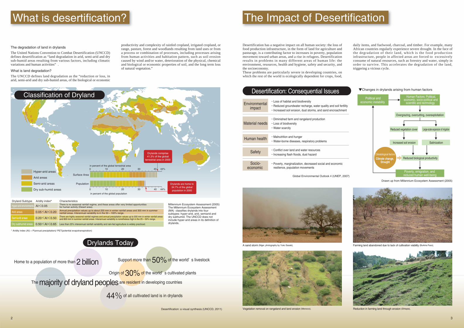
Millennium Ecosystem Assessment (2005)The Millennium Ecosystem Assessment (MA) classifies drylands into four subtypes: hyper-arid, arid, semiarid and dry subhumid. The UNCCD does not include hyper-arid areas in its definition of drylands.
Drylands Today
Home to a population of more than 2 billion Support more than 50% of the world’ s livestock
The majority of dryland peoples are resident in developing countries
Origin of 30% of the world’ s cultivated plants
44% of all cultivated land is in drylands
What is desertification? The Impact of Desertification
・Loss of habitat and biodiversity・Reduced groundwater recharge, water quality and soil fertility・Increased soil erosion, dust storms, and sand encroachment
・Diminished farm and rangeland production・Loss of biodiversity・Water scarcity
・Malnutrition and hunger・Water-borne diseases, respiratory problems
・Conflict over land and water resources・Increasing flash floods, dust hazard
・Poverty, marginalization, decreased social and economic resilience, population movements
Environmental impact
Material needs
Human health
Safety
Socio-economic
Desertification: Consequential Issues
A sand storm (Niger, photography by Yuko Sasaki). Farming land abandoned due to lack of cultivation viability (Burkina Faso).
Vegetation removal on rangeland and land erosion (Morocco). Reduction in farming land through erosion (Ethiopia).
Dryland Subtype Aridity index* Characteristics
Poverty, emigration, and reduced human well-being
Overgrazing, overcutting, overexploitation
Reduced vegetation cover
Increased soil erosion
Reduced biological productivity
Large-scale expansion of irrigation
Salinization
Human Factors: Political, economic, socio-political and
scientific and technology Political and
economic instability
Climatological factors
Climate change, Drought
▼Changes in drylands arising from human factors
Hyper-arid areas
Arid areas
Semi-arid areas
Dry sub-humid areas
Surface Area
Population
0
0 10 20 30 40 44%
10 20 30 40 44%
in percent of the global population
in percent of the global terrestrial area
Drylands comprise41.3% of the global
terrestrial area in 2000
Drylands are home to34.7% of the globalpopulation in 2000
Hyper-arid environments
Arid areas
Semiarid areas
Dry subhumid areas
AI<0.05
0.05<AI<0.20
0.20<AI<0.50
0.50<AI<0.65
There is no seasonal rainfall regime, and these areas offer very limited opportunities for human activity (Desert area).
Annual precipitation values up to about 200 mm in winter rainfall areas and 300 mm in summer rainfall areas. Interannual variability is in the 50 – 100% range.
There are highly seasonal rainfall regimes and annual precipitation values up to 500 mm in winter rainfall areas and 800 mm in summer rainfall areas. Interannual variability is nonetheless high in the 25 – 50% range.
Less than 25% interannual rainfall variability and rain-fed agriculture is widely practiced.
Classification of Dryland
* Aridity index (AI) = P(annual precipitation)/ PET(potential evapotranspiration)
4 5
Desertification is caused by two types of factor.Climate factors: e.g. global climate change, drought, aridificationHuman factors: resulting from human activity, such as overgrazing, overcutting, and overcultivation, which goes beyond the limits of the delicate ecosystems that exist in drylands. These activities cause a reduction in vegetation growth in the affected lands, accelerating the water and wind erosion that are the direct causes of desertification. These human factors are prompted by the wider socioeconomic
context, including population growth, the development of market economies, and poverty. Desertification, therefore, is intimately linked to the lives of the people who reside in the affected regions.
The United Nations Convention to Combat Desertification(*1) was established in June 1994 in order to create and implement an action plan to combat desertification in those regions and countries (particularly in Africa) facing severe drought and desertification, and to enable the support of such measures by developed countries. It was ratified by Japan in 1998. The Convention requires measures designed to combat desertification to be included in the National Action Programmes for sustainable development in those countries affected by desertification. In terms of policy, it requires countries to secure the participation of citizens, local communities, and NGOs in measures to combat desertification. It also
requires countries to take comprehensive measures based on an understanding of the complex socioeconomic factors that contribute to desertification. It also requires the promotion of centrally organized measuring, data collection and exchange, research and development, and technology transfer; this is to ensure adequate development and application of scientific knowledge and technology on desertification.Japan is working on the development of specific technologies and approaches designed in order to achieve the objectives set out in the Convention, based on an awareness of the ways of life of the people in affected areas, their livelihoods, and the need for the development and dissemination of technology appropriate to the natural environment.
Desertification is caused by two types of factor
i C i C b ifi i (*1) i i k h i
The United Nations Convention to Combat Desertification and its Progress
Human factors
Convention Objectives and Achievement Levels
Land erosion and degradation
Overcultivation and overexploitation
Sheet erosion Rill erosion Gully erosion
Overgrazing Overcutting
Forests are logged in order to expand agricultural land (Burkina Faso)
Livestock near water (Burkina Faso)
Carrying timber (Burkina Faso)
Fuelwood, charcoal, and timber on sale (Burkina Faso)
Chemical degradation
& physical
degradation
Chemical degradation includes salt build-up, lack of nutrients, acidification, and contamination by chemical substances.
Salt build-up caused by a lack of suitable irrigation is a severe problem in many areas of the world.
Physical degradation refers to the compaction and hard-setting of the top layers of soil.
Wind erosion
Surface wind causes soil dispersion and movement.
The fertile top layers of soil are dispersed by wind, making it harder to grow plants.
Water erosion
Land erosion is caused when precipitation and surface water run-off washes away soil. At first, the topsoil is washed away evenly over wide areas, in what is known as sheet erosion. The next stage is rill erosion, in which small channels, known as rills, form. These rills eventually broaden and deepen, forming V-shaped gullies; this stage is known as gully erosion. Water erosion removes fertile soil from the land, degrading its quality. This makes vegetation recovery a considerable challenge, therefore causing a decline in agricultural productivity. The result is a reduction in cultivated land area.
In 2010, an evaluation was conducted to establish the extent to which the objectives of the Convention had been achieved. The results indicated that while there has been considerable success in advocacy and education—growing awareness and understanding about desertification and land degradation—there has been little such progress in the formulation and implementation of National Action Programmes in affected countries or in the integration of investment frameworks. Further measures are required to promote greater achievement in these areas.
Vegetation is reduced and soil washed away from the surface of fields (Burkina Faso).
Rills form in areas where surface water collects (Kenya, photography by Itsuki Tanaka).
Over time, rills form larger gullies. Advanced gully erosion requires engineering work; it cannot be solved through the efforts of local people alone (Ethiopia).
(*1) United Nations Convention to Combat Desertification in Those Countries Experiencing Serious Drought and/or Desertification, Particularly in Africa (UNCCD)
The Conference of the Parties (COP) is established on a regular basis by the Convention as the
supreme decision-making body. The COP has two subsidiary bodies: the Committee on Science
and Technology (CST), intended to focus on science & technology and provide relevant policy
advice, and the Committee for the Review of the Implementation of the Convention (CRIC),
intended to conduct regular reviews of the implementation status of the Convention.
Organization of the Convention
COP10 (Changwon, Republic of Korea, October 2011)
(*2) Convention on Biological Diversity (CBD), United Nations FrameworkConvention on Climate Change (UNFCCC) and United Nations Convention to Combat Desertification (UNCCD) Global Environment Outlook 5 (UNEP, 2012)
Performance indicator Current achievement levelOverall target Target due
2018
Operational objective
Advocacy, awareness and education
Information and awareness
30% of global population informed about desertification, land degradation and drought and/or synergies with climate change and biodiversity
2014
Policy framework
National action plan alignment
80% of affected country Parties with a formulated/revised national action plan aligned to the 2008–2018 Strategic Plan
2014Joint planning of the
Rio conventions*
100% of affected country Parties with joint national action plans in place or functional mechanisms to ensure synergies between the three Rio conventions
2018Science, technology
knowledgeDryland
monitoring60% affected country Parties with established and supported national dryland monitoring systems
2014Capacity building
Dryland capacity-building
90% of affected country Parties implementing dryland-specific capacity-building initiatives
2014Finance and
technology transfer
Integrated investment framework
50% of affected country Parties with integrated investment frameworks
25%
5%
72%
38%
71%
15%
Water Erosion in Africa: How We Can Help
6 7
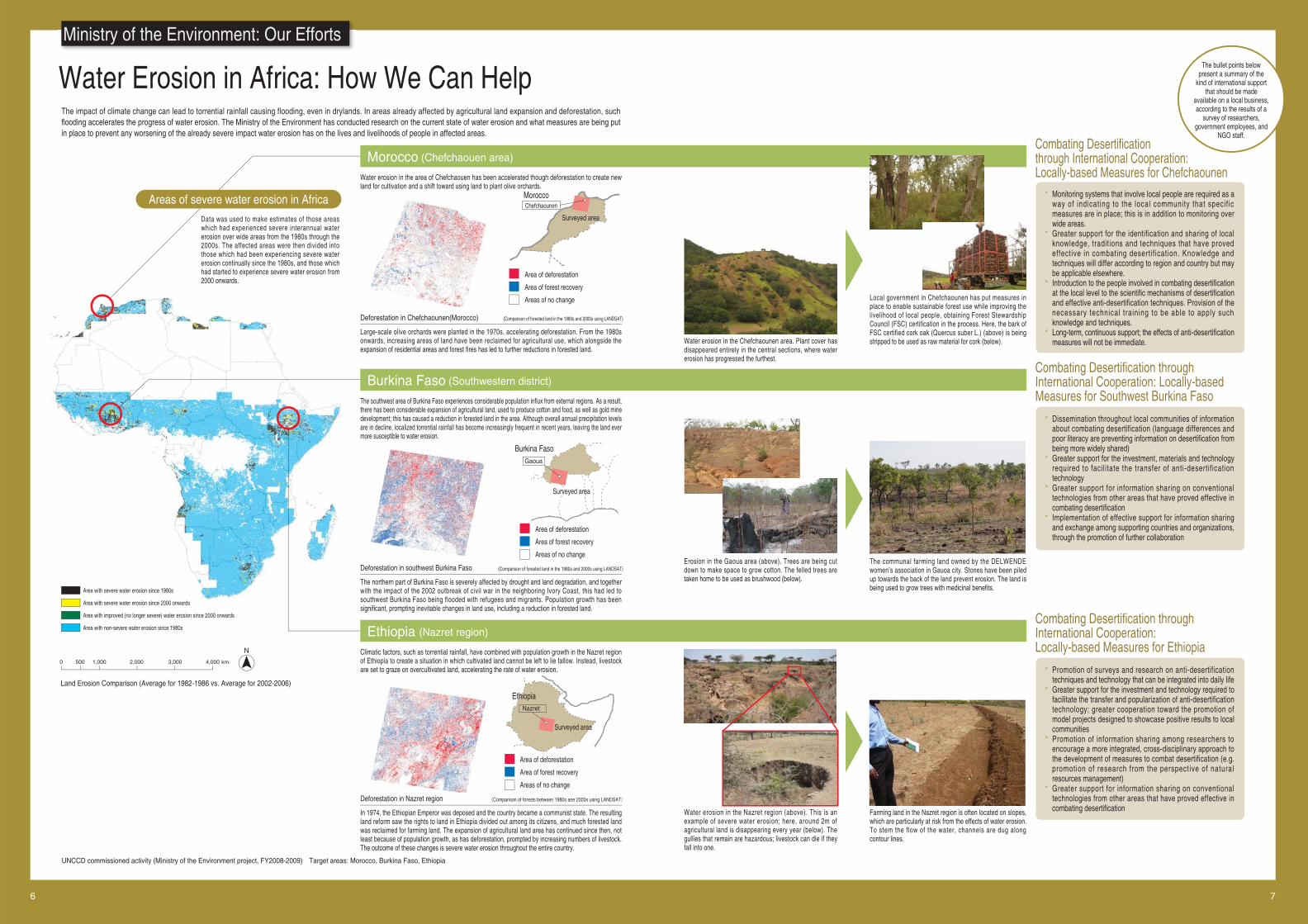
The impact of climate change can lead to torrential rainfall causing flooding, even in drylands. In areas already affected by agricultural land expansion and deforestation, such flooding accelerates the progress of water erosion. The Ministry of the Environment has conducted research on the current state of water erosion and what measures are being put in place to prevent any worsening of the already severe impact water erosion has on the lives and livelihoods of people in affected areas.
Ministry of the Environment: Our Efforts
* Monitoring systems that involve local people are required as a way of indicating to the local community that specif ic measures are in place; this is in addition to monitoring over wide areas.
* Greater support for the identification and sharing of local knowledge, traditions and techniques that have proved effective in combating desertif ication. Knowledge and techniques will differ according to region and country but may be applicable elsewhere.
* Introduction to the people involved in combating desertification at the local level to the scientific mechanisms of desertification and effective anti-desertification techniques. Provision of the necessary technical training to be able to apply such knowledge and techniques.
* Long-term, continuous support; the effects of anti-desertification measures will not be immediate.
* Dissemination throughout local communities of information about combating desertification (language differences and poor literacy are preventing information on desertification from being more widely shared)
* Greater support for the investment, materials and technology required to facilitate the transfer of anti-desertification technology
* Greater support for information sharing on conventional technologies from other areas that have proved effective in combating desertification
* Implementation of effective support for information sharing and exchange among supporting countries and organizations, through the promotion of further collaboration
Water erosion in the area of Chefchaouen has been accelerated though deforestation to create new land for cultivation and a shift toward using land to plant olive orchards.
Large-scale olive orchards were planted in the 1970s, accelerating deforestation. From the 1980s onwards, increasing areas of land have been reclaimed for agricultural use, which alongside the expansion of residential areas and forest fires has led to further reductions in forested land.
Water erosion in the Chefchaounen area. Plant cover has disappeared entirely in the central sections, where water erosion has progressed the furthest.
Local government in Chefchaounen has put measures in place to enable sustainable forest use while improving the livelihood of local people, obtaining Forest Stewardship Council (FSC) certification in the process. Here, the bark of FSC certified cork oak (Quercus suber L.) (above) is being stripped to be used as raw material for cork (below).
Erosion in the Gaoua area (above). Trees are being cut down to make space to grow cotton. The felled trees are taken home to be used as brushwood (below).
The communal farming land owned by the DELWENDE women’s association in Gauoa city. Stones have been piled up towards the back of the land prevent erosion. The land is being used to grow trees with medicinal benefits.
Water erosion in the Nazret region (above). This is an example of severe water erosion; here, around 2m of agricultural land is disappearing every year (below). The gullies that remain are hazardous; livestock can die if they fall into one.
Farming land in the Nazret region is often located on slopes, which are particularly at risk from the effects of water erosion. To stem the flow of the water, channels are dug along contour lines.
UNCCD commissioned activity (Ministry of the Environment project, FY2008-2009) Target areas: Morocco, Burkina Faso, Ethiopia
Morocco (Chefchaouen area)
Burkina Faso (Southwestern district)
Ethiopia (Nazret region)
Deforestation in Chefchaounen(Morocco) (Comparison of forested land in the 1980s and 2000s using LANDSAT)
The southwest area of Burkina Faso experiences considerable population influx from external regions. As a result, there has been considerable expansion of agricultural land, used to produce cotton and food, as well as gold mine development; this has caused a reduction in forested land in the area. Although overall annual precipitation levels are in decline, localized torrential rainfall has become increasingly frequent in recent years, leaving the land ever more susceptible to water erosion.
The northern part of Burkina Faso is severely affected by drought and land degradation, and together with the impact of the 2002 outbreak of civil war in the neighboring Ivory Coast, this had led to southwest Burkina Faso being flooded with refugees and migrants. Population growth has been significant, prompting inevitable changes in land use, including a reduction in forested land.
Deforestation in southwest Burkina Faso (Comparison of forested land in the 1980s and 2000s using LANDSAT)
Climatic factors, such as torrential rainfall, have combined with population growth in the Nazret region of Ethiopia to create a situation in which cultivated land cannot be left to lie fallow. Instead, livestock are set to graze on overcultivated land, accelerating the rate of water erosion.
In 1974, the Ethiopian Emperor was deposed and the country became a communist state. The resulting land reform saw the rights to land in Ethiopia divided out among its citizens, and much forested land was reclaimed for farming land. The expansion of agricultural land area has continued since then, not least because of population growth, as has deforestation, prompted by increasing numbers of livestock. The outcome of these changes is severe water erosion throughout the entire country.
Deforestation in Nazret region (Comparison of forests between 1980s ane 2000s using LANDSAT)
Combating Desertification through International Cooperation: Locally-based Measures for Chefchaounen
Combating Desertification through International Cooperation: Locally-based Measures for Southwest Burkina Faso
* Promotion of surveys and research on anti-desertification techniques and technology that can be integrated into daily life
* Greater support for the investment and technology required to facilitate the transfer and popularization of anti-desertification technology; greater cooperation toward the promotion of model projects designed to showcase positive results to local communities
* Promotion of information sharing among researchers to encourage a more integrated, cross-disciplinary approach to the development of measures to combat desertification (e.g. promotion of research from the perspective of natural resources management)
* Greater support for information sharing on conventional technologies from other areas that have proved effective in combating desertification
Combating Desertification through International Cooperation: Locally-based Measures for Ethiopia
The bullet points below present a summary of the
kind of international support that should be made
available on a local business, according to the results of a
survey of researchers, government employees, and
NGO staff.
Area with severe water erosion since 1980s
Area with severe water erosion since 2000 onwards
Area with improved (no longer severe) water erosion since 2000 onwards
Area with non-severe water erosion since 1980s
0 500 1,000 2,000 3,000 4,000 km
Land Erosion Comparison (Average for 1982-1986 vs. Average for 2002-2006)
Data was used to make estimates of those areas which had experienced severe interannual water erosion over wide areas from the 1980s through the 2000s. The affected areas were then divided into those which had been experiencing severe water erosion continually since the 1980s, and those which had started to experience severe water erosion from 2000 onwards.
Areas of severe water erosion in Africa
N
MoroccoChefchaounen
Burkina FasoGaoua
EthiopiaNazret
Surveyed area
Surveyed area
Surveyed area
Area of deforestation
Area of forest recovery
Areas of no change
Area of deforestation
Area of forest recovery
Areas of no change
Area of deforestation
Area of forest recovery
Areas of no change
Inter-regional Transfer for Traditional Technology to Combat Desertification
8 9
Desertification caused by human factors, such as overcultivation, overgrazing and overcutting, must be viewed in the wider socioeconomic context, including population growth, the development of market economies, and poverty; desertification is intimately linked to the lives of the people who reside in the affected regions.This project focused on the identification of traditional knowledge and technology, originating in surrounding areas, which could meaningfully be applied to the affected regions. This anti-desertification technology was then introduced to the affected region, with a focus on encouraging local people to take charge of the project.
Traditional knowledge, technology, and know-how, originated in the surrounding regions and with proven results in combating desertification, was identified and introduced to the local community. Workshops and opportunities to observe the technology in practise were held in order to allow the local community to select which technologies it would like to acquire. Training was then conducted to enable local people to acquire and implement the technology; local people were encouraged to be the main actors in the process of popularizing and encouraging the acceptance of the new technology.
In order to verify and evaluate the effects of transferred technology, the project initially commissioned test groups to introduce the target technology, then share their results with the entire region. This approach was chosen to encourage local people to assess the benefits of the target technology as well as the progress of project activities. Japanese and local NGOs provided support in coordinating and managing the project, enabling detailed follow-up of community activities.
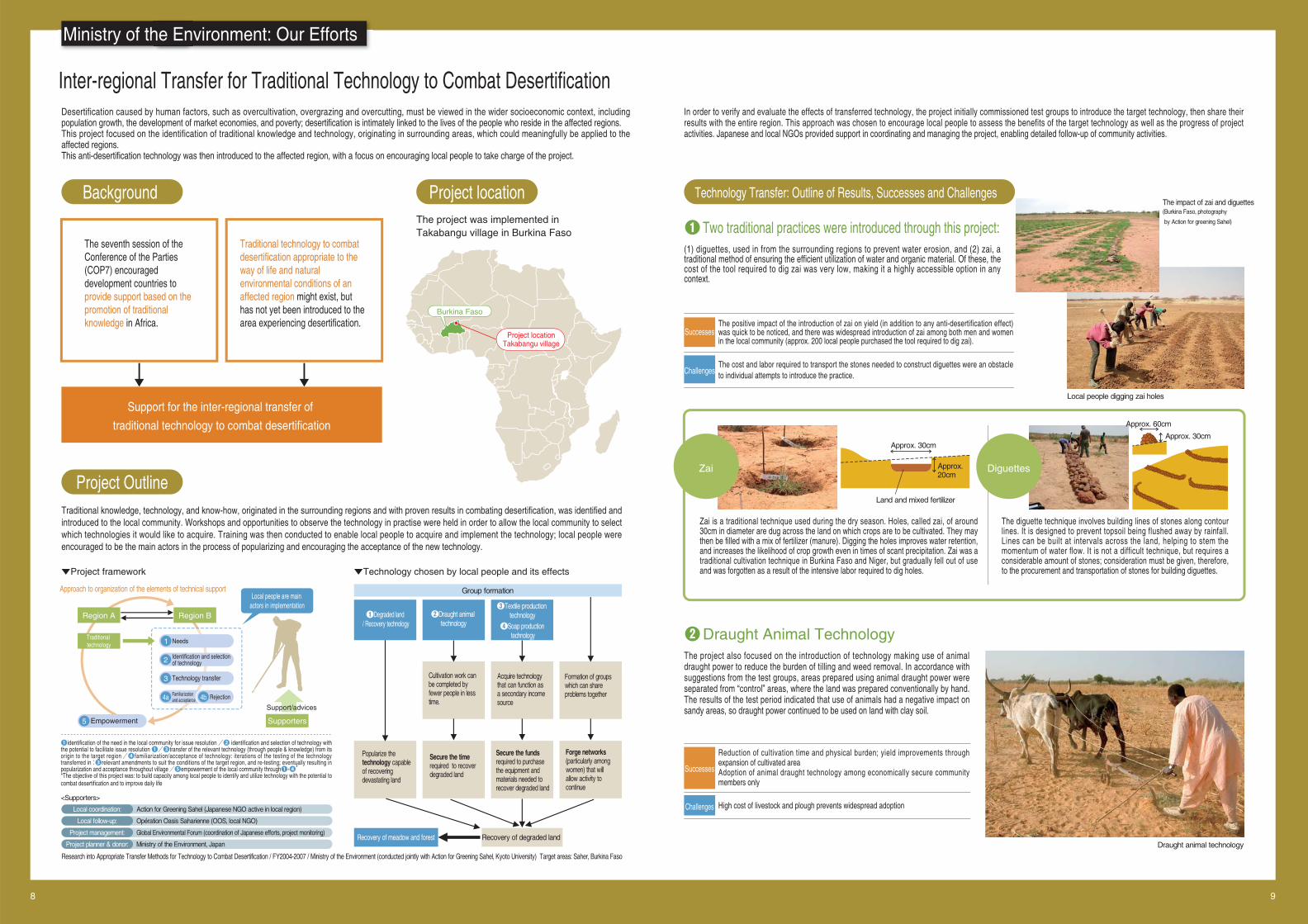
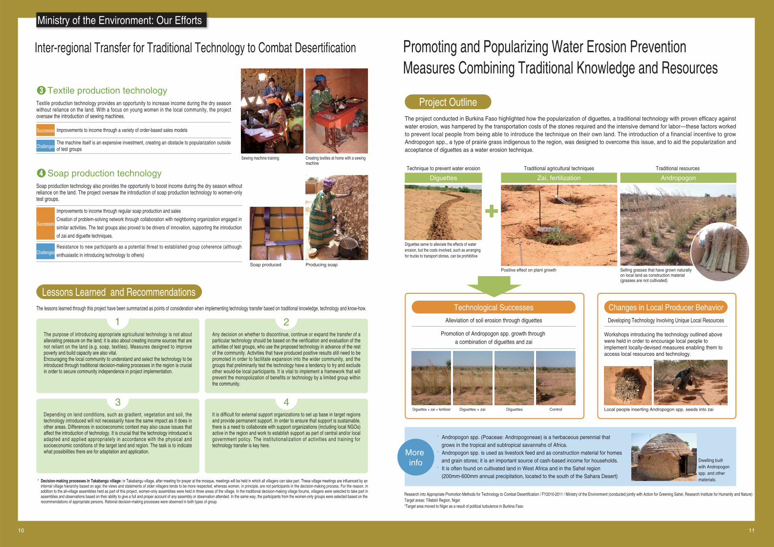
(1) diguettes, used in from the surrounding regions to prevent water erosion, and (2) zai, a traditional method of ensuring the efficient utilization of water and organic material. Of these, the cost of the tool required to dig zai was very low, making it a highly accessible option in any context.
The project was implemented in Takabangu village in Burkina Faso
The positive impact of the introduction of zai on yield (in addition to any anti-desertification effect) was quick to be noticed, and there was widespread introduction of zai among both men and women in the local community (approx. 200 local people purchased the tool required to dig zai).
The cost and labor required to transport the stones needed to construct diguettes were an obstacle to individual attempts to introduce the practice.
Ministry of the Environment: Our Efforts
Research into Appropriate Transfer Methods for Technology to Combat Desertification / FY2004-2007 / Ministry of the Environment (conducted jointly with Action for Greening Sahel, Kyoto University) Target areas: Saher, Burkina Faso
The impact of zai and diguettes (Burkina Faso, photography
by Action for greening Sahel)
Background Project location
Project Outline
Technology Transfer: Outline of Results, Successes and Challenges
❶ Two traditional practices were introduced through this project:
Successes
Challenges
The project also focused on the introduction of technology making use of animal draught power to reduce the burden of tilling and weed removal. In accordance with suggestions from the test groups, areas prepared using animal draught power were separated from “control” areas, where the land was prepared conventionally by hand. The results of the test period indicated that use of animals had a negative impact on sandy areas, so draught power continued to be used on land with clay soil.
Reduction of cultivation time and physical burden; yield improvements through expansion of cultivated areaAdoption of animal draught technology among economically secure community members only
High cost of livestock and plough prevents widespread adoption
❷ Draught Animal Technology
Successes
Challenges
The diguette technique involves building lines of stones along contour lines. It is designed to prevent topsoil being flushed away by rainfall. Lines can be built at intervals across the land, helping to stem the momentum of water flow. It is not a difficult technique, but requires a considerable amount of stones; consideration must be given, therefore, to the procurement and transportation of stones for building diguettes.
Zai is a traditional technique used during the dry season. Holes, called zai, of around 30cm in diameter are dug across the land on which crops are to be cultivated. They may then be filled with a mix of fertilizer (manure). Digging the holes improves water retention, and increases the likelihood of crop growth even in times of scant precipitation. Zai was a traditional cultivation technique in Burkina Faso and Niger, but gradually fell out of use and was forgotten as a result of the intensive labor required to dig holes.
Local people digging zai holes
Draught animal technology
DiguettesZai
The seventh session of the Conference of the Parties (COP7) encouraged development countries to provide support based on the promotion of traditional knowledge in Africa.
Traditional technology to combat desertification appropriate to the way of life and natural environmental conditions of an affected region might exist, but has not yet been introduced to the area experiencing desertification.
Support for the inter-regional transfer of
traditional technology to combat desertification
▼Project framework ▼Technology chosen by local people and its effects
Local coordination:
Local follow-up:
Project management:
Project planner & donor:
Action for Greening Sahel (Japanese NGO active in local region)
Opération Oasis Saharienne (OOS, local NGO)
Global Environmental Forum (coordination of Japanese efforts, project monitoring)
Ministry of the Environment, Japan
❶identification of the need in the local community for issue resolution /❷ identification and selection of technology with the potential to facilitate issue resolution ❶/❸transfer of the relevant technology (through people & knowledge) from its origin to the target region/❹familiarization/acceptance of technology: iterations of the testing of the technology transferred in:❸relevant amendments to suit the conditions of the target region, and re-testing; eventually resulting in popularization and acceptance throughout village/❺empowerment of the local community through❶-❹**The objective of this project was: to build capacity among local people to identify and utilize technology with the potential to combat desertification and to improve daily life
Approach to organization of the elements of technical support
5 Empowerment
Region A Region B
Traditional technology
Supporters
Project locationTakabangu village
Approx. 30cm
Land and mixed fertilizer
Approx. 20cm
Approx. 60cm
Approx. 30cm
<Supporters>
2 Identification and selectionof technology
3 Technology transfer
4a Familiarization and acceptance 4b Rejection
1 Needs
Support/advices
Local people are main actors in implementation
❶Degraded land / Recovery technology
❷Draught animal technology
❸Textile production technology
❹Soap production technology
Group formation
Recovery of degraded land Recovery of meadow and forest
Popularize the technology capable of recovering devastating land
Secure the time required to recover degraded land
Secure the funds required to purchase the equipment and materials needed to recover degraded land
Forge networks (particularly among women) that will allow activity to continue
Cultivation work can be completed by fewer people in less time.
Acquire technology that can function as a secondary income source
Formation of groups which can share problems together
Burkina Faso
Inter-regional Transfer for Traditional Technology to Combat Desertification
10 11
Promoting and Popularizing Water Erosion Prevention Measures Combining Traditional Knowledge and Resources
Textile production technology provides an opportunity to increase income during the dry season without reliance on the land. With a focus on young women in the local community, the project oversaw the introduction of sewing machines. The project conducted in Burkina Faso highlighted how the popularization of diguettes, a traditional technology with proven efficacy against
water erosion, was hampered by the transportation costs of the stones required and the intensive demand for labor—these factors worked to prevent local people from being able to introduce the technique on their own land. The introduction of a financial incentive to grow Andropogon spp., a type of prairie grass indigenous to the region, was designed to overcome this issue, and to aid the popularization and acceptance of diguettes as a water erosion technique.
Improvements to income through a variety of order-based sales models
The machine itself is an expensive investment, creating an obstacle to popularization outside of test groups
❸ Textile production technology
Successes
Challenges
Soap production technology also provides the opportunity to boost income during the dry season without reliance on the land. The project oversaw the introduction of soap production technology to women-only test groups.
Improvements to income through regular soap production and sales
Creation of problem-solving network through collaboration with neighboring organization engaged in
similar activities. The test groups also proved to be drivers of innovation, supporting the introduction
of zai and diguette techniques.
Resistance to new participants as a potential threat to established group coherence (although
enthusiastic in introducing technology to others)
❹ Soap production technology
Successes
Challenges
* Andropogon spp. (Poaceae: Andropogoneae) is a herbaceous perennial that grows in the tropical and subtropical savannahs of Africa.
* Andropogon spp. is used as livestock feed and as construction material for homes and grain stores; it is an important source of cash-based income for households.
* It is often found on cultivated land in West Africa and in the Sahel region (200mm-600mm annual precipitation, located to the south of the Sahara Desert)
Sewing machine training Creating textiles at home with a sewing machine
Producing soapSoap produced
* Decision-making processes in Takabangu village: in Takabangu village, after meeting for prayer at the mosque, meetings will be held in which all villagers can take part. These village meetings are influenced by an internal village hierarchy based on age; the views and statements of older villagers tends to be more respected, whereas women, in principle, are not participants in the decision-making process. For the reason, in addition to the all-village assemblies held as part of this project, women-only assemblies were held in three areas of the village. In the traditional decision-making village forums, villagers were selected to take part in assemblies and observations based on their ability to give a full and proper account of any assembly or observation attended. In the same way, the participants from the women-only groups were selected based on the recommendations of appropriate persons. Rational decision-making processes were observed in both types of group.
Depending on land conditions, such as gradient, vegetation and soil, the technology introduced will not necessarily have the same impact as it does in other areas. Differences in socioeconomic context may also cause issues that affect the introduction of technology. It is crucial that the technology introduced is adapted and applied appropriately in accordance with the physical and socioeconomic conditions of the target land and region. The task is to indicate what possibilities there are for adaptation and application.
It is difficult for external support organizations to set up base in target regions and provide permanent support. In order to ensure that support is sustainable, there is a need to collaborate with support organizations (including local NGOs) active in the region and work to establish support as part of central and/or local government policy. The institutionalization of activities and training for technology transfer is key here.
3 4
The purpose of introducing appropriate agricultural technology is not about alleviating pressure on the land; it is also about creating income sources that are not reliant on the land (e.g. soap, textiles). Measures designed to improve poverty and build capacity are also vital. Encouraging the local community to understand and select the technology to be introduced through traditional decision-making processes in the region is crucial in order to secure community independence in project implementation.
Any decision on whether to discontinue, continue or expand the transfer of a particular technology should be based on the verification and evaluation of the activities of test groups, who use the proposed technology in advance of the rest of the community. Activities that have produced positive results still need to be promoted in order to facilitate expansion into the wider community, and the groups that preliminarily test the technology have a tendency to try and exclude other would-be local participants. It is vital to implement a framework that will prevent the monopolization of benefits or technology by a limited group within the community.
Lessons Learned and Recommendations
Project Outline
1 2
Diguettes
Technique to prevent water erosion
Zai, fertilization
Traditional agricultural techniques
Andropogon
Traditional resources
Diguettes serve to alleviate the effects of water erosion, but the costs involved, such as arranging for trucks to transport stones, can be prohibitive
Positive effect on plant growth
Dwelling built with Andropogon spp. and other materials.
Local people inserting Andropogon spp. seeds into zai
Selling grasses that have grown naturally on local land as construction material (grasses are not cultivated)
More info
Technological Successes
Alleviation of soil erosion through diguettes Developing Technology Involving Unique Local Resources
Promotion of Andropogon spp. growth through a combination of diguettes and zai
Changes in Local Producer Behavior
Workshops introducing the technology outlined above were held in order to encourage local people to implement locally-devised measures enabling them to access local resources and technology.
ControlDiguettesDiguettes + zaiDiguettes + zai + fertilizer
The lessons learned through this project have been summarized as points of consideration when implementing technology transfer based on traditional knowledge, technology and know-how.
Research into Appropriate Promotion Methods for Technology to Combat Desertification / FY2010-2011 / Ministry of the Environment (conducted jointly with Action for Greening Sahel, Research Institute for Humanity and Nature) Target areas: Tillabéri Region, Niger*Target area moved to Niger as a result of political turbulence in Burkina Faso
Ministry of the Environment: Our Efforts
12 13
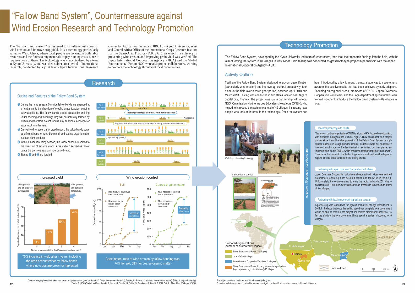
The “Fallow Band System” is designed to simultaneously control wind erosion and improve crop yield. It is a technology particularly suited to West Africa, where local people are lacking in both labor resources and the funds to buy materials or pay running costs, since it requires none of these. The technology was conceptualized by a team at Kyoto University, and was then subject to a period of international research, conducted by a joint team (Japan International Research
Center for Agricultural Sciences (JIRCAS), Kyoto University, West and Central Africa Office of the International Crops Research Institute for the Semi-Arid Tropics (ICRISAT), in which its efficacy in preventing wind erosion and improving grain yield was verified. The Japan International Cooperation Agency (JICA) and the Global Environmental Forum NGO were also project collaborators, working to promote the technology throughout local communities.
“Fallow Band System”, Countermeasure against Wind Erosion Research and Technology Promotion
Research
Technology Promotion
❶ During the rainy season, 5m-wide fallow bands are arranged at a right angle to the direction of erosive winds (eastern wind) in cultivated fields. The fallow bands can be created by omitting usual seeding and weeding; they will be naturally formed by weeds and therefore do not require any additional economic or labor input from farmers.
❷ During the dry season, after crop harvest, the fallow bands serve as efficient traps for wind-blown soil and coarse organic matter such as plant residues.
❸ In the subsequent rainy season, the fallow bands are shifted to the direction of erosive winds. Areas which served as fallow bands the previous year can now be cultivated.
❹ Stages ❷ and ❸ are iterated.
Testing of the Fallow Band System, designed to prevent desertification (particularly wind erosion) and improve agricultural productivity, took place in the field over a three year period, between April 2010 and March 2013. Testing was conducted in two states located near Niger’s capital city, Niamey. The project was run in partnership with a local NGO, Organisation Nigérienne des Educateurs Novateurs (ONEN), who helped to introduce the system to a total of 42 villages, instructing local people who took an interest in the technology. Once the system had
been introduced by a few farmers, the next stage was to make others aware of the positive results that had been achieved by early adopters. Focusing on regional areas, members of ONEN, Japan Overseas Cooperation Volunteers, and the Loga department agricultural bureau worked together to introduce the Fallow Band System to 89 villages in total.
Millet grown on land left fallow the previous year
Millet grown on land cultivated continuously
The project partner organization ONEN is a local NGO, focused on education, with members throughout the whole of Niger. ONEN was chosen as a project partner since it would enable promotion of the Fallow Band System through school teachers in village primary schools. Teachers were not necessarily involved in all stages of the familiarization activities, but they played an important part, as did ONEN, which brings the teachers together in a network. Thanks to this network, the technology was introduced to 44 villages in regions outside those targeted in the testing project.
Data and images given above taken from papers and presentations given by: Ikazaki, K. (Tokyo Metropolitan University), Tanaka, U. (Research Institute for Humanity and Nature), Shinjo, H. (Kyoto University), Tobita, S. (JIRCAS) et al, and from: Ikazaki, K., Shinjo, H., Tanaka, U., Tobita, S., Funakawa, S., Kosaki, T. 2011. Soil Sci. Plant. Nutr. 57 (4) :pp. 573-586.
The project above was conducted as a JICA Partnership Program:Formation and dissemination of practical techniques for mitigation of desertification and improvement of household income
Workshops introducing technology
Global Environmental Forum (30 villages)
Local NGOs (44 villages)
Japan Overseas Cooperation Volunteers (5 villages)
Global Environmental Forum & local governmental organizations (Loga department agricultural bureau) (10 villages)
Instruction material
Outline and Features of the Fallow Band System
Activity Outline
Year 1: Rainy season
Year 1: Dry season
Year 2: Rainy season
Year 2: Dry season
Year 3:Rainy season
Year 3:Dry season
5m 5m
Wind direction
30~60m
No seeding or weeding (no action taken) → formation of fallow bands
Improved crop growth
Trapped soil and coarse organic matter (no action taken) → build-up of nutrients, wind erosion control
Increased yield Wind erosion control
Soil Coarse organic matter
75% increase in yield after 4 years, including the area accounted for by fallow bands where no crops are grown or harvested
Containment ratio of wind erosion by fallow banding was 74% for soil, 58% for coarse organic matter
Number of years since Fallow Band System was introduced (years)
Prop
ortio
nal in
crea
se in
yie
ld fo
r who
le c
ultiv
ated
land
(%)
Cum
ulat
ive
mas
s (M
g/ha
)
Jan
250
80
60
40
20
200
150
Mar May Jul Sep
100
50
0
Cum
ulat
ive
mas
s (k
g/ha
)
Jan
700
Mar May Jul Sep
600
500
400
300
200
100
0
75%
54%
32%
11%
Mass measured on windward side of fallow bands
Mass measured on leeward side of fallow bands
Mass measured on windward side of fallow bands
Mass measured on leeward side of fallow bands
Trapped by fallow bands
Trapped by fallow bands
The Fallow Band System, developed by the Kyoto University-led team of researchers, then took their research findings into the field, with the aim of testing the system in 40 villages in west Niger. Field testing was conducted as grassroots-type project in partnership with the Japan International Cooperation Agency (JICA).
Teachers partnering with NGOs
Japan Overseas Cooperation Volunteers already active in Niger were enlisted as partners, enabling more detailed action and follow-up in the field. Unfortunately, the volunteers had to leave the region in March 2011 due to political unrest. Until then, two volunteers had introduced the system to a total of five villages.
Partnering with Japan Overseas Cooperation Volunteers
A partnership was formed with the agricultural bureau of Loga Department, in 2011, in the hope that once the testing period was complete local government would be able to continue the project and related promotional activities. So far, the efforts of the local government have seen the system introduced to 10 villages.
Partnering with local government (agricultural bureau)
Promoted organizations (number of promoted villages) Tillabéri region
Tahoua region
Maradi region
Zinder region
Dosso region
Niamey
0 100 200 km
N
Partnerships for T
echnology Prom
otion
Niger
Sahara desert
Diffa region
Agadez region
1 2 3 4
14 15
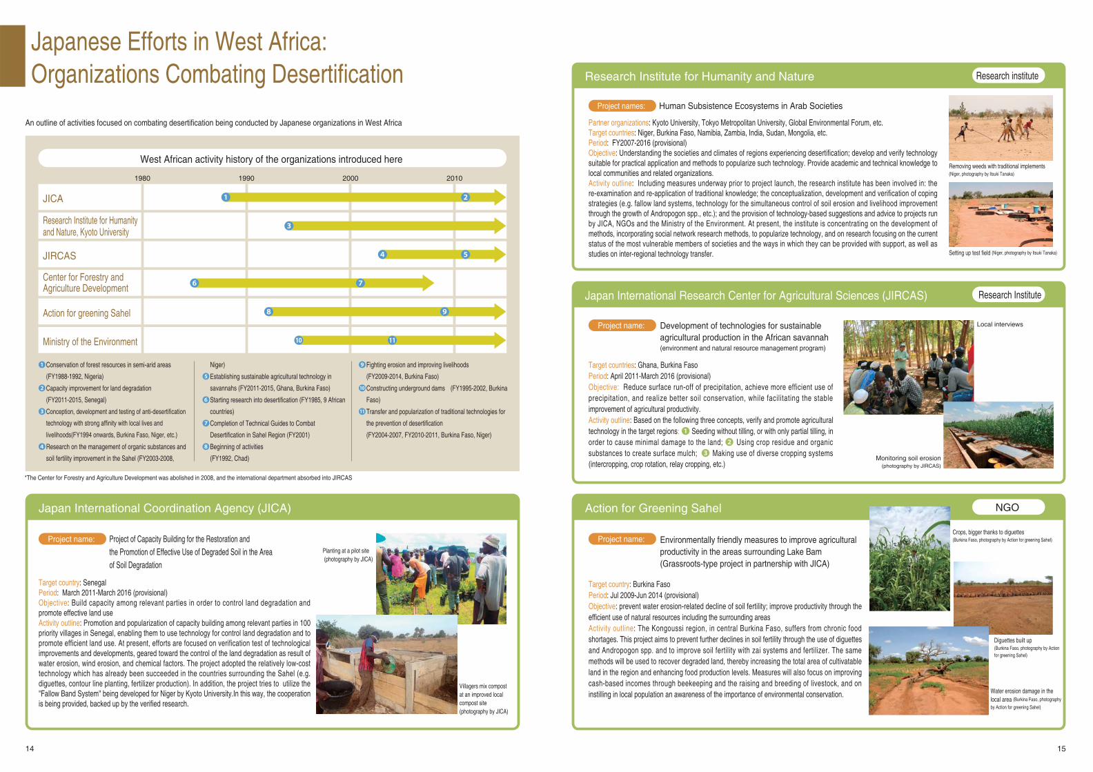
Japanese Efforts in West Africa: Organizations Combating Desertification
Target countries: Ghana, Burkina FasoPeriod: April 2011-March 2016 (provisional)Objective: Reduce surface run-off of precipitation, achieve more efficient use of precipitation, and realize better soil conservation, while facilitating the stable improvement of agricultural productivity.Activity outline: Based on the following three concepts, verify and promote agricultural technology in the target regions: ❶ Seeding without tilling, or with only partial tilling, in order to cause minimal damage to the land; ❷ Using crop residue and organic substances to create surface mulch; ❸ Making use of diverse cropping systems (intercropping, crop rotation, relay cropping, etc.)
Partner organizations: Kyoto University, Tokyo Metropolitan University, Global Environmental Forum, etc.Target countries: Niger, Burkina Faso, Namibia, Zambia, India, Sudan, Mongolia, etc.Period: FY2007-2016 (provisional)Objective: Understanding the societies and climates of regions experiencing desertification; develop and verify technology suitable for practical application and methods to popularize such technology. Provide academic and technical knowledge to local communities and related organizations.Activity outline: Including measures underway prior to project launch, the research institute has been involved in: the re-examination and re-application of traditional knowledge; the conceptualization, development and verification of coping strategies (e.g. fallow land systems, technology for the simultaneous control of soil erosion and livelihood improvement through the growth of Andropogon spp., etc.); and the provision of technology-based suggestions and advice to projects run by JICA, NGOs and the Ministry of the Environment. At present, the institute is concentrating on the development of methods, incorporating social network research methods, to popularize technology, and on research focusing on the current status of the most vulnerable members of societies and the ways in which they can be provided with support, as well as studies on inter-regional technology transfer.
Target country: Burkina FasoPeriod: Jul 2009-Jun 2014 (provisional)Objective: prevent water erosion-related decline of soil fertility; improve productivity through the efficient use of natural resources including the surrounding areasActivity outline: The Kongoussi region, in central Burkina Faso, suffers from chronic food shortages. This project aims to prevent further declines in soil fertility through the use of diguettes and Andropogon spp. and to improve soil fertility with zai systems and fertilizer. The same methods will be used to recover degraded land, thereby increasing the total area of cultivatable land in the region and enhancing food production levels. Measures will also focus on improving cash-based incomes through beekeeping and the raising and breeding of livestock, and on instilling in local population an awareness of the importance of environmental conservation.
Target country: SenegalPeriod: March 2011-March 2016 (provisional)Objective: Build capacity among relevant parties in order to control land degradation and promote effective land useActivity outline: Promotion and popularization of capacity building among relevant parties in 100 priority villages in Senegal, enabling them to use technology for control land degradation and to promote efficient land use. At present, efforts are focused on verification test of technological improvements and developments, geared toward the control of the land degradation as result of water erosion, wind erosion, and chemical factors. The project adopted the relatively low-cost technology which has already been succeeded in the countries surrounding the Sahel (e.g. diguettes, contour line planting, fertilizer production). In addition, the project tries to utilize the "Fallow Band System" being developed for Niger by Kyoto University.In this way, the cooperation is being provided, backed up by the verified research.
Japan International Research Center for Agricultural Sciences (JIRCAS)
Research Institute for Humanity and Nature
Action for Greening SahelJapan International Coordination Agency (JICA)
An outline of activities focused on combating desertification being conducted by Japanese organizations in West Africa
Research Institute
Research institute
West African activity history of the organizations introduced here
NGO
Local interviews
Monitoring soil erosion (photography by JIRCAS)
Removing weeds with traditional implements(Niger, photography by Itsuki Tanaka)
Water erosion damage in the local area (Burkina Faso, photography
by Action for greening Sahel)
Diguettes built up(Burkina Faso, photography by Action for greening Sahel)
Crops, bigger thanks to diguettes(Burkina Faso, photography by Action for greening Sahel)
Villagers mix compost at an improved local compost site (photography by JICA)
*The Center for Forestry and Agriculture Development was abolished in 2008, and the international department absorbed into JIRCAS
Setting up test field (Niger, photography by Itsuki Tanaka)
Development of technologies for sustainable agricultural production in the African savannah (environment and natural resource management program)
Project name:
Project names:
Project name: Project name:
Human Subsistence Ecosystems in Arab Societies
Environmentally friendly measures to improve agricultural productivity in the areas surrounding Lake Bam(Grassroots-type project in partnership with JICA)
Project of Capacity Building for the Restoration and the Promotion of Effective Use of Degraded Soil in the Area of Soil Degradation
JICA
JIRCAS
Center for Forestry and Agriculture Development
Action for greening Sahel
Research Institute for Humanity and Nature, Kyoto University
Ministry of the Environment
1980 1990 2000 2010
Niger)
❺ Establishing sustainable agricultural technology in
savannahs (FY2011-2015, Ghana, Burkina Faso)
❻ Starting research into desertification (FY1985, 9 African
countries)
❼ Completion of Technical Guides to Combat
Desertification in Sahel Region (FY2001)
❽ Beginning of activities
(FY1992, Chad)
❶ Conservation of forest resources in semi-arid areas
(FY1988-1992, Nigeria)
❷ Capacity improvement for land degradation
(FY2011-2015, Senegal)
❸ Conception, development and testing of anti-desertification
technology with strong affinity with local lives and
livelihoods(FY1994 onwards, Burkina Faso, Niger, etc.)
❹ Research on the management of organic substances and
soil fertility improvement in the Sahel (FY2003-2008,
❾ Fighting erosion and improving livelihoods
(FY2009-2014, Burkina Faso)
10 Constructing underground dams (FY1995-2002, Burkina
Faso)
11 Transfer and popularization of traditional technologies for
the prevention of desertification
(FY2004-2007, FY2010-2011, Burkina Faso, Niger)
❶ ❷
❹
❻ ❼
❽
❸
10 11
❾
❺
Planting at a pilot site (photography by JICA)


![THIRD NATIONAL REPORT ON IMPLEMENTATION …9 DESERTIFICATION FIJI THIRD NATIONAL REPORT ON IMPLEMENTATION OF THE UNITED NATION CONVENTION TO COMBAT DESERTIFICATION [UNCCD] REPUBLIC](https://img.pdfslide.us/doc/110x75/5f0a74657e708231d42bb727/third-national-report-on-implementation-9-desertification-fiji-third-national-report.jpg)