Embed Size (px)
Citation preview

LIBRARY
MLtBRTS'i miBRTA.ri®FK!B
ATLAS OF ANCIENT EGYPT.
WITH COMPLETE INDEX,
GEOGEAPHIOAL AND HISTORICAL NOTES,
BIBLICAL REEERENCES, ETC.
SPECIAL PUBLICATION
OF THE
E G Y P T E X P L O R A T I O N FUND.
L O N D O N : SOLD BY
K E G A N P A U L , T R E N C H , ' T H U B N E E & CO. PATERNOSTER HOUSE, CHARING CROSS ROAD, W.C.
B E E N A E D Q U A E I T C H , 15, PICCADILLY, W.
ASHEE & CO., 13, BEDFORD ST., COVENT GARDEN, W.C.
EGYPT EXPLOEATION EUNL, 37, GREAT EUSSELL ST., W.C.
fOp230stte tlie Bontish MusenmJ.
1894^

CONTENTS.
PAGE
P R E F A C E . . . . . .
INTRODUCTION . . . . . i
M . N A V I L L E ' S GEOGRAPHICAL DISCOVERIES RELATING
TO THE R O U T E OF T H E E X O D U S . . . 7
BIBLICAL R E F E R E N C E S TO L O C A L I T I E S IN E G Y P T . 17
CHRONOLOGICAL T A B L E OF T H E E G Y P T I A N D Y N A S T I E S . 20
A N C I E N T AND M O D E R N A U T H O R I T I E S FOR EGYPTIAN
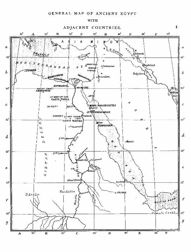
GEOGRAPHY AND H I S T O R Y . . . . 21 G E N E R A L M A P OF A N C I E N T EGYPT, W I T H A D J A C E N T
C O U N T R I E S . . . . . NO. I
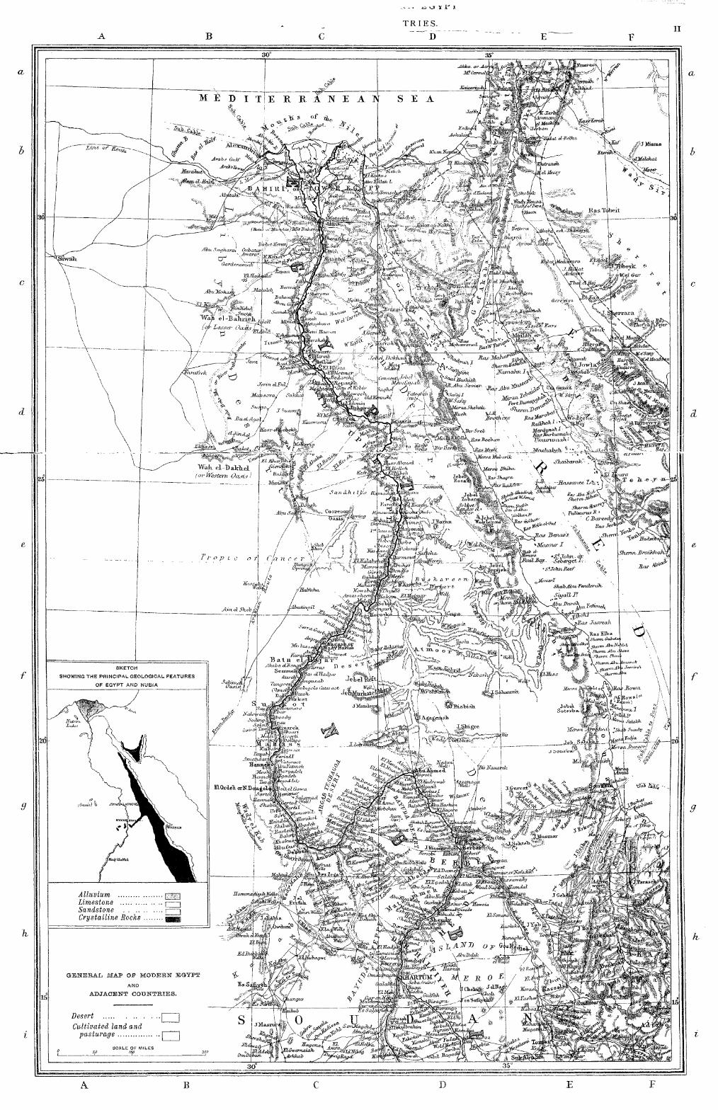
G E N E R A L M A P OF M O D E R N E G Y P T , W I T H A D J A C E N T ,, 11
C O U N T R I E S . . . . . .
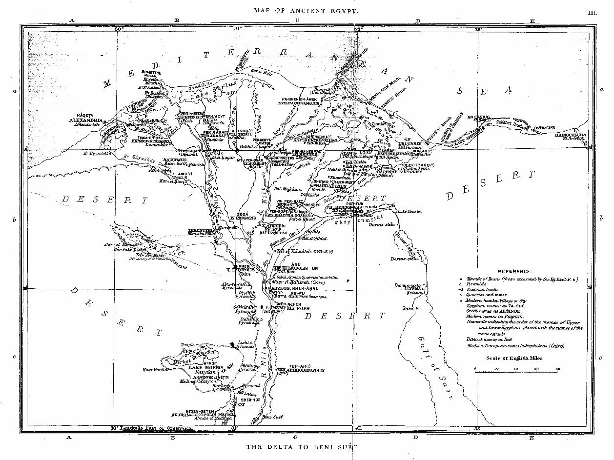
M A P OF A N C I E N T E G Y P T — T H E D E L T A TO B E N I S U E F . ,, i i i
Tables of the NomeSj with thejr Capitals, and the Gods worshipped in them—(l to XX of Lower Egypt and XX—xxil of Upper Egypt).
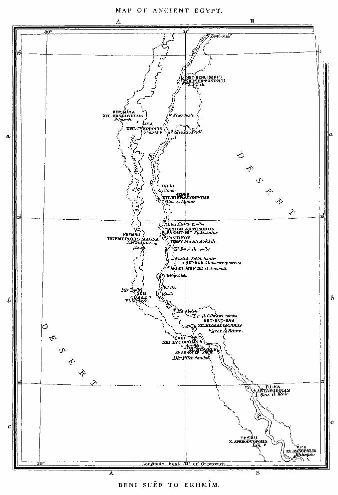
M A P OF A N C I E N T E G Y P T — F R O M B E N I S U E F TO E K H M I M ,, iv
Tables of the Nomes, with their Capitals and the Gods worshipped in them—(ix to XIX of Upper Egypt).
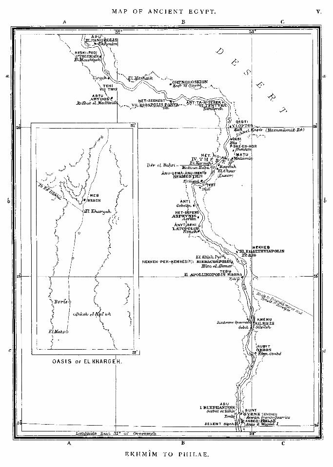
M A P OF A N C I E N T EGYPT—FROXM E K H M I M TO P H I L A E . ,, v
Tables of the Nomes, with their Capitals and the Gods worshipped in them—(l to IX of Upper Egypt).
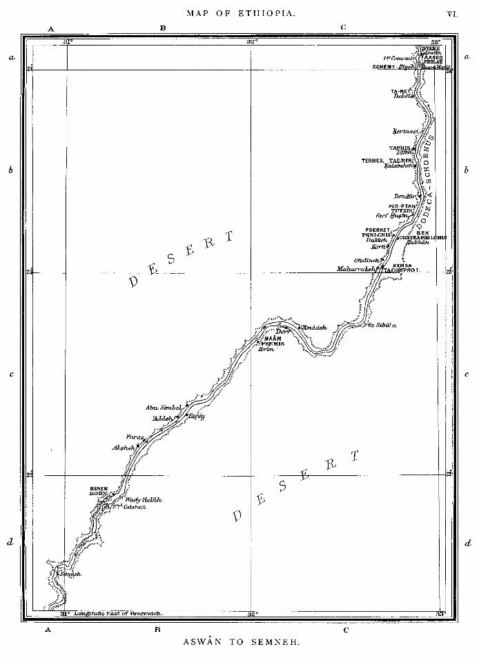
M A P OF E T H I O P I A — F R O M A S W A N TO S E M N E H
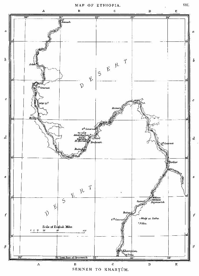
,, FROM S E M N E H TO K H A R T U M
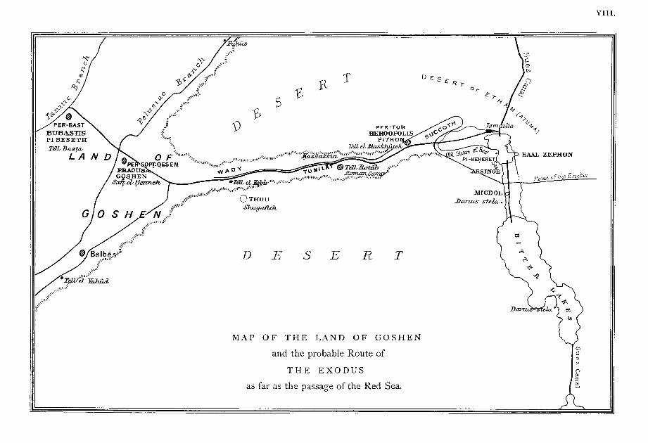
M A P OF G O S H E N AND T H E PROBABLE R O U T E OF T H E
E X O D U S . . . . . .
I N D E X TO M A P OF M O D E R N E G Y P T
I N D E X TO M A P S OF A N C I E N T E G Y P T , E T H I O P I A , ETC.
„ VI
,, VII
„VIII
pp. i -
„viii-
-vii
-xi

PREFACE.
T H E Committee of the Egypt Exploration Fund issues this volume of Maps of Ancient Egypt as a Special Publication, in the belief that many of its friends and subscribers may desire to possess such an Atlas exhibiting the latest identifications of ancient sites, and more especially marking the important geographical discoveries which have resulted from the work of the Society.
Egypt changes but little; and the modern Map, with the natural as well as the artificial features depicted upon it, will give a truer Insight into the physiography of the country In ancient times than the skeleton maps of Ancient Egypt which follow it. This map also shows the lines of the modern desert roads (which generally coincide with those of the old roadways), the Egyptian railway system, and the Suez Canal; It will therefore be appreciated by travellers, as well as by arch^ological enquirers. Opposite to the maps of Ancient Egypt will be found tables containing the names of the Nomes and their capitals, and of the local gods, but the state of our present knowledge does not enable us to delineate their boundaries; which, moreover, often varied.
Maps of the Wady Tumilat and the Land of Goshen have already been published by the Egypt Exploration Fund as part of the results of M. Naville's researches conducted for the Society, and explained at length In his Memoirs of 1884 and 1887. The present Map of that district Is compiled from them, and extracts from the Memoirs which bear upon the maps are also reprinted. A reference list of locaHties In Egypt m.entioned In the Bible is appended for the use of Bible students.
Since this Atlas will doubtless fall Into the hands of many who have had neither time nor opportunity for the study of Egyptology, Interested as they may be in its results, a few notes on certain geographical aspects of Ancient Egyptian history are here given.

I N T R O D U C T I O N .
T H E A N C I E N T E G Y P T I A N S AND T H E I R C O U N T R Y ;
T H E I R F O R E I G N I N T E R C O U R S E .
T h e E g y p t i a n populat ion, its origin and character.— The land of Egypt, stretching from the Mediterranean to Aswan on the Nubian frontier, has an area of only 10,292 square miles, with a present population of nearly 7 millions, or about 600 people to the square mile. In extent the country has remained unaltered from remotest historic times, but its ancient population Is supposed to have been more dense than that of to-day ; in the age of Josephus (A.D. 37—100) it appears to have numbered at least 7J millions. Some authorities hold that the Ancient Egyptians were of African origin, and from the South. Others maintain that they came from the North-East by the isthmus of Suez; or from the East by Kus and Coptos; or from the South-East by the straits of Bab el Mandeb; their original home, according to these several opinions, having been in Asia Minor, in Central Asia, or in South Arabia. But, whatever their origin, this at least is clear to us—from the earliest times of which any historic record survives, the strong, mystic, and subtle individuality of the people was fully marked and developed; and the physical characteristics of their country are so correspondingly distinctive that it Is difficult not to consider these as the main cause of that distinction in life, religion^ and art which is so much a thing apart that we can only describe It as Ancient Egyptian.
E g y p t "the gift of the Ni le ." T h e De l ta and its changes .—Egypt Is Httle more than the bed of the Nile. Her fertile Delta was formed by the accumulation of alluvial deposits at the mouth of the river during pre-historic times, and was so called by the Greeks on account of the resemblance of Its outline to that of the fourth letter of their alphabet. In the maps of this Atlas the courses of the river and canals, and the outlines of lakes are represented as those of the present day, since it is impossible to
2 T H E D E L T A AND ITS C H A N G E S .
restore the ancient beds with certainty. The Greek historians and geographers tell us that the Nile divided Into three main branches at the southern point of the Delta, and that these subdivided, so that the river entered the sea by seven channels, of which five were natural, and two artificial. But these have all more or less changed, dwindled, or disappeared. In order of East to West, they were named by the Greeks—the Pelusiac, Tanitic, Mendesian, Phatnitic, Sebennytic, Bolbitine, and Canopic branches, generally after the principal cities through which they passed. In the days of Herodotus, the fork of the river was three or four miles north of where Cairo stands; It is now some ten miles further north still. The Rosetta and Damietta branches of the Nile are its two chief outlets at the present day, and they may be taken as roughly corresponding with the Canopic and Phatnitic channels. The Pelusiac branch has disappeared. The elusive character of the internal geography of Ancient Egypt largely results from natural variations in the distribution of the waters of the river; from great artificial changes of the water-system (notably those made In the times of Mena, the first historic king; of the xiith and xixth Dynasties; and of the Ptolemies); and, lastly, to the cumulative effects of local irrigation continued for thousands of years.
Low^er a n d U p p e r E g y p t , N u b i a , a n d t h e F a i y u m . — To the Egyptians, the Delta was *'the Land of the North^^ (or Lower Egypt). The rest of their country was ^^the Land of the South'^ (or Upper Egypt), and extended from the apex of the Delta to that bank of granite which crosses the Nile at about 24^' N. latitude and produces the *'first cataract.'' This cataract marked the confines of the Land of Nubia (the Ethiopia of Greek and Roman geographers), known to the Egyptians as the Land of Kash, and one of their earliest conquests. Upper Egypt (including the Faiyum) has an average width of only 10 miles, with a length of about 450; and this also Is *'the gift of the Nile.""* It Is hemmed in by the hills of the Arabian and Libyan deserts, and its rich black soil is entirely formed of the deposit left by the annual overflowing of the river. The Faiyum is a natural depression surrounded by the Libyan hills, 840 square miles in area, and about 50 miles south-
^ JEerodotus I I , 5.
L O W E R AND U P P E R E G Y P T , N U B I A , AND T H E F A I Y U M . 3
west of Cairo. The Bahr Yusif, a water-course diverging from the river near Asyut, enters the Faiyum through the gorge of El Lahun, and thus connects the province with the valley of the Nile. The Faiyum was anciently renowned for its fertility, and is still well cultivated; its name Is derived from an Egyptian word signifying *'marsh, or lake distrlct,^^ through its Coptic form oi Phiom. Here was the celebrated ' 'Lake Moeris'^ of the Greeks, the admiration of Herodotus and the work of the xiith Dynasty kings who built the adjoining '^Labyrinth," and were buried near to it, within the pyramids of Hawareh and El Lahun. These kings turned the natural lake, formed by drainage and the annual overflow of the Nile, into the artificially controlled reservoir of Lake Moeris. At its highest, the original lake of the Faiyum had almost covered the province; as reduced, It seems to have had a perimeter of 136 miles, and a greatest depth of 230 feet.^ To the ancient inhabitants their river was Hapi^ and their country Kemty the Black Land; while the sandy desert was Tesert^ the Red Land. The Greeks called the country Aiguptos, and Its river Neilos, whence, through the Latin forms of ^gyphts and Nihts, come our names of Egypt and the Nile. Little or no rain falls in Upper Egypt, although the climate is said to be now changing In this respect. The necessary irrigation of the crops has always depended upon the due storing and distribution of the waters of the yearly inundation.
A n c i e n t Quar r ies .—Owing to the scarcity of woodj Egyptian buildings were generally made of bricks of Nile-mud: monumental works were constructed of hard or fine-grained stones, which were abundantly found in the rocky edges of the Nile valley. The rock on both sides of the river, and as far as Silsileh, was limestone of various quaUtles, and there is hardly half a mile of cliff without quarries; perhaps the finest quality was obtained opposite Memphis at Turra. A patch of hard quartzite Is found close to Cairo at Kum el Ahmar, and numerous fine monuments In this material exist. Alabaster was quarried especially In the Het Nub region on the east bank from Minyeh to Asyut. In the southern portion of Upper Egypt, sandstone took the place of Hmestone as the chief
2 See The Fayum and Lake Moeris, by Major E. H. BEOWN, E.E., Inspector General of Irrigation, Upper Egypt; 1892.
4 M Y T H O L O G Y .
material for stone construction, and the most notable quarry is at Gebel Silsileh, where the rocks on either side approach and overhang the river, so that the removal of the blocks was easily effected. Red granite and some grey granite were quarried at Aswan, the cataract at Syene being formed by a vein of this Syenite^ crossing the river valley. Between the Nile and the Red Sea was a great variety of fine materials, such as basalt, granite, diorlte, porphyry; the latter, perhaps, worked only by the Romans. The difficulties of obtaining them did not deter even the earliest kings of the ivth Dynasty from making the freest use of these stones for their ^ monuments of eternity.^'
E g y p t i a n m y t h o l o g y ; its connect ion w i t h the geography of E g y p t . — T h e true sources of their beneficent Nile, and the causes of its regular rise and fall in the summer and autumn months were as unknown to the Ancient Egyptians as the origin of the great Sun himself. As that set nightly behind the Western hills, so to the Egyptians the West was that land of darkness to which their dead passed on; and their great cities of the dead (or cemeteries), were always preferably founded upon the west bank of the river. In very early times travellers' tales of the oases of the Libyan waste doubtless helped them to believe that beyond the perils of the desert and of death the islands of the blest were to be found. They deified all regular and persistent natural phenomena which they recognised as such, and chief among their good gods were different forms of the Sun; and Osiris, the fertilizing power of the river. But the barren desert, ever ready to encroach upon their tilled and fertile fields, was inimical to all the amenities of life in the eyes of a settled and agricultural people such as they were.^ The desert was therefore personified In the destructive god Set; and between Set and Osiris there had been constant rivalry and warfare corresponding to the unending encroachments of desert on fertile land, and fertile land on desert.
T h e State Re l ig ion and the Government ; their feudal character .—The gods of the Ancient Egyptians were essentially
^ Tiiis iSj however, not the true Syenite of mineralogists.
2 Incidental reference is made to this fact in Genesis XLVii, 31—34. The '' shepherds" here referred to were nomads of the Eastern desert, who were always troublesome to the Egyptians.

T H E S T A T E R E L I G I O N AND T H E G O V E R N M E N T . 5
local gods—gods of a district, or even of a city. Their chief deities were of the Sun, the Earth, the principal planets and stars, and the Nile; all these being worshipped under different aspects, and considered both as gods of the living and of the dead. Their common nature made it easy for any one of the local gods to be regarded as national, if his city became the chief seat of government and the home of the reigning dynasty. The kings were supposed to be of divine descent, and were, theoretically, the great high priests of their dominions; so that, notwithstanding the number and variety of their local deities, the Egyptians still had a national religion. The system of government can best be described as feudal; It was bound up with the state religion, and its administration was based upon the subdivision of the land.
T h e N o m e s and their Princes.—Upper and Lower Egypt were divided Into some forty provinces, the number and boundaries of which might vary from time to time. These provinces were called hesep by the natives, and by the Greeks nomot] whence the modern term Nomes. Each nome had its farm-land; Its marshes for fowling and the cultivation of papyrus reeds; Its canal; and its capital, which was the centre of the provincial religion and administration. Great vassal princes were the hereditary rulers of the nomes, and high priests of the local temples, being responsible to the king for the due maintenance of civil order, and military efficiency. Their duties consisted In loyalty to the person and interests of the king, in care for the well-being of their vassals, and In the military discipline and command of all their able-bodied men.^
Communica t ion w i t h foreign nations.—Sometimes the king sent his nobles on exploring and aggressive expeditions, whence they were expected to return with treasure which it might please them to call the gifts or tribute of other lands. Such expeditions brought back fine material for the use of the sculptor, precious metals, stones, woods, and Incense, costly articles of foreign art and manufacture, natural curiosities and products,—vegetable, animal, and sometimes human,—and added to the variety of
1 See the biographical inscriptions of "£eni Hasan i " and "Beni Sasan ii" for particulars as to the conduct of exemplary monarchs.
6 C O M M U N I C A T I O N W I T H F O R E I G N N A T I O N S .
the indigenous flora and fauna of Egypt, which Is naturally but limited. Hostile, commercial, and general national Intercourse was thus gradually established with Nubia and the Sudan, the Libyan and other North African peoples, desert tribes, the Inhabitants of the Sinaitic peninsula, Syria, Babylonia, and Mesopotamia, the traders and dwellers on the coasts of the Red Sea and in Arabia, the kingdoms of Asia Minor, the Phoenicians, and the pre-Homeric Greeks. In the seventh century Greek colonists (traders and mercenary troops) were formally recognised by the Egyptians.
T h e i n v a s i o n s of E g y p t by foreign na t ions .—Egypt was conquered by the Hyksos^ not much later than 2000 B.C.; by the Ethiopians under Sabako B.C. 700; by the Assyrians under Esarhaddon and Assurbanipal B.C. 672—665; by the Persians under Cambyses B.C. 525; and fell, as part of the empire of Persia, into the hands of Alexander B.C. 333. But it is only from the Hebrews and from Greeks, by birth or culture, that we have any foreign accounts of her civilisation before It was merged in that of the Roman Empire. The Greeks linked the life of Ancient Egypt with that of Europe; and it is primarily to Greek accounts that we owe our first knowledge of this country of their conquest and adoption.
2 The Hyksos have not yet been identified. They are stated by Josephus to have been " Shepherd Kings/^ and to have come from the North East.
SUMMARY OF
M. N A V I L L E ' S GEOGRAPHICAL D I S C O V E R I E S
RELATING TO THE S o j O U R N OF THE ISRAELITES IN E G Y P T ,
AND TO
T H E R O U T E OF T H E E X O D U S .
In the first and fourth ' 'Memoirs" of the Egypt Exploration Fund, M. Navllle has endeavoured to trace the route of the Exodus; his conclusions are drawn from the results of his excavations and researches at Saft-el-Henneh studied in the light of ancient historical and geographical records. These conclusions, with the arguments that led to them, are here summarised, and followed by an extensive quotation of the chapter on the ' Route of the Exodus" from his Memoir entitled The Store City of Pi thorn}
Up to 1883, the mound of Tell el Maskhutah was supposed by Egyptologists to occupy the site of the city of Raamses {Exodus i, 11); In the spring of that year M. Navllle found it to be on that of Pithom.
By the study of the Inscriptions on monuments which had already been taken from the place and were then In Ismalllah, and of those which he himself discovered among the ruins, M. Navllle found that the god of the city had been Tum, that Its religious name had been Pi-Tum—the Abode of Tum, and that the temple had been situate in the civil city of Thukut. The name Pi-Tum corresponds with the Hebrew Pithom, the Coptic Pethom, and the Pithom and Peitho of the Septuaglnt. The founder of the place appeared to be Rameses ll (xixth Dynasty, B.C. 1300—1250),^ who is usually supposed to be the Pharaoh of the Oppression, and It had evidently been built as a fortified military store-house or granary [Exodzis i, 11); (the Hebrew word here means store-hottses, the Septuagint
1 The third and revised edition of M. Naville's Store City of Pithom and the Route of the Exodus was published in 1887, after the discovery and excavation of Goshen, and the friendly criticism of the First Edition by Biblical critics and Egyptologists all the world over.
2 The dates of Ancient Egyptian history, in round numbers, as given throughout this letter-' press, are, as far as possible, in accordance with those to which Professor Plinders Petrie has recently given currency in his lectures delivered at University College, London.
8 P I T H O M AND S U C C O T H .
translates y(?r/z)f^^ cities), In which provisions were gathered for the use of armies or caravans bound across the Eastern desert. The bricks of which these '* military store-houses" were built were composed of the common material, Nile mud, mixed with chopped straw, but in places they were apparently made without straw [Exodus V, 6—ig).
The name Thuku occurs repeatedly in those letters of scribes and ofiicials of the x ix th Dynasty which constitute the so-called Anastasi papyri, and is there followed by the determinative (a hieroglyphic symbol, marking the nature of the preceding word), indicating a borderland Inhabited by foreigners. In these writings the name denotes a district including ^^the lakes of Pithom of Menephthes, which is of Thuku," and it Is hence clear that before becoming the civil name of the capital, Thuku designated a region, or district, containing Pithom. Such was the meaning of the name under the x ix th Dynasty. M. Navllle also gives his philological reasons for considering Succoth {Exodus xii, 2)7 i XIII, 2o) as the Hebrew equivalent of Thuku.^
Among the Roman ruins of the mound M. Navllle further discovered two inscribed stones, one bearing the words E R O CASTRA,
the camp of Ero ; and the second reading as follows:— Dominis nostris victoribuSj Maxifniano et Severo imperatoribus, et
Maximino et Constantino nobilissimis CaesaribuSj ab Ero in Clusma, M. Villi—e.
Under our victorious lords, the emperors Maximianus and Severus, and the most illustrious Caesars Maximinus and Constantine, from Ero to Clusma there are nine miles—Niite.
As was usual in the Roman provinces where Greek was spoken, the distance is given both in Latin and Greek, and the Q at the end of the last line stands for nine. This Roman milestone was the means of leading M. Navllle to the conclusion that Pi-Tum was the Heroopolis of the Greeks. In the English Bible {Genesis XLVI,
28), we read that Jacob, going to Egypt, ' 'sent Judah before him unto Joseph, to direct his face unto Goshen." Here the Septuagint, whose writers must have known the geography of Egypt, translates instead o f unto Goshen," unto ' 'Heroopolis in the land of Ramses." The Memphite Coptic version, which was translated from the
3 I t must here be said that Brugsch's philological argument for the identification of Thukut and Succoth is not admitted by M. Maspero.
T H E R E D S E A . 9
Septuagint, keeps the old name of the city, and has "near Pethom, the city in the land of Ramses"; showing that at the time when this version was made, in the fourth century A.D., Hero5polis was still for the natives the abode of the God " T U M , " who possibly was not yet dethroned by Christianity. In Egyptian, Ar or Era, when followed by the hieroglyphic sign denoting a building, means a store-house, and the first part of the Greek name for this store city may be the Greek transliteration of the Egyptian word ''Era!' The Greek and Roman writers who speak of Heroopolis are unanimous in declaring that the city was near the sea, at the head of the Arabian Gulf, which was also called Heroopolitan, and hence it is assumed that even in the times of the Romans the Red Sea extended much further north than it does now, and that the Bitter Lakes were then under water. LInant Bey considered it geologically proved that, under the Pharaohs of the Xixth Dynasty, Lake Timsah and the valleys of Saba Blar and Abu Balah were part of the Red Sea. This view Is confirmed by the physical features of the country, for the depression of Lake Timsah has a narrow extension towards the west, presenting the appearance of the head of a gulf. The sea would thus have extended to within three miles of Heroopolis. Gradually the water withdrew, communication between city and gulf was partly cut off, and where the Red Sea had been there remained only salt marshes, which were called by Strabo and Pliny the Bitter Lakes}
M. Navllle also found at Tell el Maskhutah an historical narrative tablet of Ptolemy Phlladelphos in whose reign (B.C. 286—247) the Septuagint version of the Hebrew Scriptures was begun in Alexandria. This tablet gives many data which not only confirm the discoveries already mentioned, but also show that another great temple of the Vlllth Nome was Pikerehet, dedicated to Osiris. Pikerehet plays an important part in the tablet, the last lines of which give the amount of taxes which were granted as Income to
^ Professor Sayce (in The Higher Criticism and the Monuments, S.P.C.K. 1894; pp. 259—60) specially emphasises the objections to M. Naville's theory of the Eoute of the Exodus. Up to the present time, none of the various theories can claim sufficient proof to warrant an exclusive acceptance, and until further and careful examinations of the character, date and situation of ancient remains between Lake Timsah and the Gulf of Suez have been made, no satisfactory explanation of the Biblical statements is to be expected.
ID C I T Y O F G O S H E N .
that temple. In the different Nome lists it is also named, alternatively with Pi-Tum, as the chief sanctuary of the Vlllth Nome of Lower Egypt, and always as belonging to the region of Thuku. M. Navllle therefore concludes that this region contained two important sanctuaries very near to each other, P I T u m and Pikerehet, the latter being the closer to the sea. The Greeks called a temple of Osiris a Serapium, and the official Itinerary of the Roman Empire mentions a city of Serapium, or Seraplu, as being some eighteen miles distant from Ero; and since we know of no other temple of Osiris In the neighbourhood of Heroopolis, Pikerehet must be the Seraplu of the Itinerary. There are no traces of ruins which can be the remains of Pikerehet—Seraplu, excepting those at the foot of Gebel Mariam.
The tablet speaks of the horses and cattle given to the sanctuary of Pikerehet for its annual support. Passages from a Xllth Dynasty papyrus {circa B.C. 2500), which tells of the political exile and long wanderings of an Egyptian nobleman called Saneha, and others from one of the Xixth Dynasty Anastasi papyri already mentioned, indicate that the more immediate eastern neighbourhood of Pi-Tum was known as the estate or farm of Pharaoh. Now the '^before Pi-hahiroth" of Exodus xiv, 2, is translated in the Septuagint and the Coptic versions as ^'before the farm.'^ Hence M. Navllle concludes that the Pi-hahiroth of the Hebrews was the Pikerehet of the Nome lists, and of the tablet of Ptolemy Phlladelphos.
GOSHEN. M. NAVILLE'S researches at Saft-el-Henneh led him to identify It
as the site of PI Sopt (the Abode of Sopt), which was the religious capital of the xxth Nome of Lower Egypt. This Nome was known to the Egyptians as the Nome of Sopt or Soptakhem, and Professor Brugsch discovered that It was Identical with the Arabian Nome of Greek and Roman writers. The civil capital of the Nome was Pa Kes, from which came its Greek name of Phacusa {Pha-Cusd). M. Navllle found this name '^Kes^^ in the inscriptions of the shrine of Nectanebo ll (xxxth Dynasty, B.C. 367—350), at Saft-el-Henneh, and in such connections as showed that It
L A N D O F G O S H E N . I I
was at the civil capital called ' 'Kes," that Nectanebo erected this shrine, in the religious capital, ' T i Sopt." Therefore Phacusa (^Ta Kes'^), the secular capital, and Pi Sopt or Pa Sopt, the religious capital of the XXth Nome, both stood upon the site now occupied by the modern village of Saft-el-Henneh. The names of Goshen and Phacusa have the samic origin in ancient Egyptian.•'• In the Septuagint the land of Goshen is called Gesem of Arabia, i.e., Gesem, which is in the No7ne of Arabia, and the term, though strictly referring to a limited district, may yet have applied to the whole country occupied by the Israelites. Kesem (Gesem) is mentioned in such connections, and with such hieroglyphic determinatives In the Temple lists of offerings from the various districts, as to show that it is the civil name of the district and city in which stood the Temple of Sopt, the God of the Arabian Nome, and hence the land of Goshen was the country around Saft-el-Henneh, within the triangle formed by the villages of Saft, Belbels and Tel-el-Kebir. Again, the Coptic translation of Genesis XLV, IG, gives for our Goshen—Kesem of T—arabia; and T—arabia * the Arabia" in Coptic corresponds to what the Arabs call the Hauf, i.e., the land between the Nile and the Red Sea, which constitutes the present province of Sharkieh, and where the Nome of Arabia was situate. M. Navllle further concludes that at the time when the Israelites occupied the land, the name ' 'Goshen ^ belonged to a region which had as yet no definite boundaries, and which extended with the Increase of the people over the territory they inhabited. H e also thinks that the term ''land of Ramses ^ {Genesis XLVII, I I ) applied to a larger area, and included that part of the Delta which lies to the eastward of the Tanitic branch, a country which Rameses II (xixth Dynasty, B.C. 1300—1250) enriched with innumerable works of architecture, and which corresponds with the present province of Sharkieh. The city of Raamses {Exodus \, 11) was situate in the Arabian Nome, but Its identification cannot be regarded as established.
1 In the Proceedings of the Society of Biblical Archaeology for June 1893, and writing on the newly ascertained Egyptian personification and worship of the zodiacal lights of the morning and evening twilights—the God Sopt being that divine personification, and Pi Sopt or Pa Sopt the chief seat of his worship—Brugsch shows that Gesem, the Coptic form of the ancient Egyptian name Keset, which was the name of the civil city Phacusa, means " the city of the twilights." The land of Goshen was so called as belonging to the city of Goshen.
THE ROUTE OF T H E EXODUS.
' Among the historical events upon which the discovery of Pithom tends to throw light, one of the most important is certainly the Exodus, and the route which the Israelites followed in going out of Egypt. The Israelites were settled in the land of Goshen, in a region which perhaps extended further northward, but which certainly comprehended the Wady Tumilat, wherein was situated the city of Pithom, where, according to the Septuagint, Jacob and Joseph met when the Patriarch came to Egypt. Bound for Palestine, two different routes lay before them. The northern route had been followed by the great conquerors. It went from Tanis to the Syrian coast; It was the shortest way, but it went through several fortresses, particularly the great stronghold of Zar, Besides, the first part of it crossed a well-cultivated and irrigated land occupied by an agricultural population, which was not a land of pasture necessary for a people of shepherds. This northern route is called In the Bible, the way of the land of the Philistines; and, from the first, before any other indication as to the direction they followed, it is said that the Israelites did not take that road. The other was the southern route, which their ancestor Jacob had taken before them, and which, according to LInant Bey, was still followed by the Bedawin of our days before the opening of the canal. They w^ent straight from El Arish to the valley of Saba Biar; while the traders, travelling through Kantarah, Salihieh, and Korein, followed very nearly the old northern route. The Israelites had only to go along the canal as far as its opening Into the Arabian Gulf at a short distance from Succoth ; then, pushing straight forward, they would skirt the northern shore of the Gulf, and reach the desert and the Palestine way without having any sea to cross.
' 'The children of Israel journeyed from Rameses to Succoth.'^ It Is useless now to discuss the site of the city of Rameses, which will only be ascertained by further excavations. It is quite possible that we must here understand the name as referring to the land of Rameses rather than to the city; the land must have been either west or north of Pithom. The first station is Succoth, Thukttt, or Thuk^t. Here it is important to observe that the name of the
E T H A M . 13
place where the Israelites first encamped Is not the name of a city but the name of a district, of the region of Thukut, In which, at the time of the Exodus, there existed not only Pithom, but the fortifications which Rameses II, his predecessor, and successor had erected to keep off the plundering tribes of Bedawin. It is quite natural that the camping ground of such a large multitude must have had a great extent. It was not at Pithom that the Israelites halted; the gates of the fortified city were not opened to them, nor were the store-houses. Besides, the area of the enclosure would have been quite insufficient to contain such a vast crowd. They pitched their tents in the land of Succoth where Pithom was built, very likely near those lakes and those good pastures to which the nomads of Atuma asked to be admitted with their cattle.
There has been much discussion about the site of the next station, Etham, which has always been considered as a city, and even as a fortress. The name Succoth, that of a region, shows that we are not to look for a city of Etham, but for a district, a region of that name. Saneha says in his papyrus that, leaving the Lake of Kemuer, he arrived with his companion at a place called Atima, which could not be very far distant. Let us now consult a document of the time of the Exodus, the papyrus Anastasi VI, and read in M. Brugsch^s translation, '' We have allowed the tribes of the Shasu of the land of Atuma to pass the stronghold of King Menephtah of the land of Succoth, towards the lakes of Pithom of King Menephtah of the land of Sticcoth ; in order to feed themselves and to feed their cattle in the great estate of Pharaoh}' That is what I consider as the region of Etham, the land which the papyri call Atima, Atma, Atuma. It was Inhabited by Shasu nomads, and as it was insufficient to nourish their cattle, they were obliged to ask to share the good pastures which had been assigned to the Israelites. The hieroglyphic determinative of its name indicates that it was a borderland. Both the nature of the land and its name seem to agree very well with what was said of Etham, that it was ''on the edge of the wilderness" {Exodus xiii, 20).
Another reason which induces me to think that Etham was a region, and not a city, is that in Niimbers (xxxiii, 6, 7, 8) we read of the ''wilderness of Etham," in which the Israelites marched three
14 E T H A M AND S U C C O T H .
days after having crossed the sea. This desert, then, would have extended very far south of the city from which it derived Its name; and one does not see how Etham, an Egyptian city, would have given its name to a desert inhabited by a Semitic population on the opposite side of the sea.
I believe, therefore, Etham to be the region of Atuma; the desert which began at Lake Timsah and extended west and south of it, near the Arabian Gulf. As this desert was occupied by Shasu and Satlu, Asiatic nomads of Semitic race, they may have had, somewhere on the shore opposite to Egypt, a sanctuary dedicated to their god Baal Zephon ; and this was not necessarily a large place. It may have been a small monument, a place of worship or of pilgrimage, like those numberless shekhs^ tombs which are found on the hills and mountains of Egypt.
The Israelites leaving Succoth, a region which we now know well, the neighbourhood of Tell el Maskhutah, push forward towards the desert, skirting the northern shore of the gulf, and thus reach the wilderness of Etham; but there, because of the pursuit of Pharaoh, they have to change their course: they are told to retrace their steps so as to put the sea between them and the desert.
The next indications of Holy Writ can only be determined con-jecturally. Surveys and excavations are needed to give us accurate information. However, although It Is impossible yet to bring forward positive evidence in favour of this or that theory, I will attempt to trace the route followed, relying on what seems most probable.
"And the Lord spake unto Moses, saying: 'Speak unto the children of Israel that they turn and encamp before Pi-hahiroth, between Migdol and the sea, over against Baal-Zephon; before it shall ye encamp by the sea. '" {Exodtts xiv, 2).
We must bear In mind that the sea was only at a very short distance from Succoth, and that it covered the valley of Saba Biar. Judging from the appearance of the ground, as it is given in the maps, it is clear that the gulf must have been very narrow in the space between Lake Timsah and the Bitter Lakes. We have left the Israelites in the land of Atuma, on the northern shore of the Arabian Gulf, at the edge of the wilderness. There they receive
MiGDOL AND THE PASSAGE OF THE R E D SEA. 15
the command to camp near the sea, so as to be separated by the gulf from the desert which they had to cross. They are obliged, therefore, to turn back; to pass between Pithom and the end of the gulf, somewhere near Magfar, then to march towards the south to the place which is indicated as their camping ground. The question now is, Where are we to look for Migdol and Pi-Hahirothl
As for Migdol, the ancient authors, and particularly the Itinerary, mention a Migdol, or Magdolen, which was twelve Roman miles distant from Pelusium. It is not possible to admit that this is the same Migdol which is spoken of in Exodus, for then it would not be the Red Sea, but the Mediterranean, which the Israelites would have before them, and we should thus have to fall in with MM. Schleiden and Brugsch's theory that they followed the narrow track which lies between the Mediterranean and Serbonian bog. However Ingenious are the arguments on which this system is based, I believe it must now be dismissed altogether, because we know the site of the station of Succoth. Is it possible to admit that from the shore of the Arabian Gulf, the Israelites turned to the north, and marched forty miles through the desert in order to reach the Mediterranean ? The journey would have lasted several days ; they would have been obliged to pass in front of the fortresses of the north ; they would have fallen into the way of the land of the Philistines, which they were told not to take; and, lastly, the Egyptians, issuing from Tanis and the northern cities, would have easily intercepted them.
Besides, when the text speaks of the sea, it is natural to think that it means the sea which is close by, of which they are skirting the northern coast, and not that other sea, which is forty miles distant. All these reasons induce me to give up definitively the idea of the passage by the north, and to return to the old theory of a passage of the Red Sea, but of the Red Sea as it was at that time, extending a great deal farther northward, and not the Red Sea of to-day, which occupies a very different position.
The Egyptian form of the word Migdol is a very common name; it means z.fort, a tower. It is very likely that in a fortified region there have been several places so called, distinguished from each
i6 MIGDOL AND THE PASSAGE OF THE RED SEA.
other, either by the name of the king who built them, or by some local circumstance; just as there are in Italy a considerable number of Torre. I should, therefore, with M. Ebers, place Migdol at the present station of the Serapeum. There the sea was not wide, and the water probably very shallow; there also the phenomenon which took place on such a large scale when the Israelites went through, must have been well known, as It is often seen now in other parts of Egypt. As at this point the sea was liable to be driven back under the Influence of the east wind, and to leave a dry way, the Pharaohs were obliged to have there a fort, a Migdol, so as to guard that part of the sea, and to prevent the Asiatics of the desert from using this temporary gate to enter Egypt, to steal cattle and to plunder the fertile land which was round Pithom. That there was one spot particularly favourable for crossing because of this well-known effect of the wind, is indicated by the detailed description of the place where the Israelites are to camp. There is a striking difference between this description and the vague data which we find before and after. It is not only said that they are to camp near the sea, but the landmarks are given, Pi-Hahlroth, Migdol, Baal Zephon, so that they could not miss the spot, which, perhaps, was very restricted.
We have now the landmarks of the camping ground of the Israelites : on the north-west Pi-Hahiroth, Pikerehet, not very far from Pithom ; on the south-east Migdol, near the present Sera-peum; In front of them the sea; and opposite, on the Asiatic side, on some hill like Shekh Ennedek, Baal Zephon. There, In the space between the Serapeum and Lake Timsah, the sea was narrow, the water had not much depth, the east wind opened the sea, and the Israelites went through.
This seems to me, at present, the most probable route of the Exodus. I think it agrees best with what we know of the geographical names, and of the nature of the land. Besides, it does not suppose very long marches, which would have been quite impossible with a large multitude; the distances are not very great, and on that account the information which we owe to the Roman milestone is invaluable."
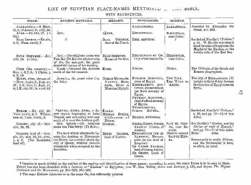
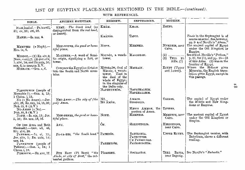
LIST OF EGYPTIAN PLACE-NAMES MENTIOlNi:.!^ WITH REFERENCES.
. . . ^ i^iJ3LE,
BIBLE.
ALEXANDRIA.—3 Mace, i i i . l ; cf Actsvi, 9; xvm,24.
AVEN.—Ez. XXX, 17. ( = On).
BAAL ZEPHON.—Ex.xiv, 2, 9; Num. xxxiii, 7.
B E T H xliii, 13.
SHEMESH.—Jer . (=0n).
ANCIENT EGYPTIAN.
CUSH (the country).— Gen. X, 6 ,7 ,8; 1 Chron. i, 8, 9, 10.
EGYPT, river, stream of. —Num. xxxiv, 5; Josh, xv, 47; 2 K. xxiv, 7; Josh, xv, 4; 1 K. viii, 65; Is. xxvii,12.
ETHAM. —Ex. xiii, 20; Num. xxxiii, 6, 7. Wilderness of, Num. xxxiii, 8.
GOSHEN, city of.-xlvi, 28, 29.
-Gen.
GOSHEN, land of.—Gen. xlv, 10; xlvi, 28, 34; xlvii, 1, 4, 6. [See RAMESES, land of].
ANU.
ANU.—Its religious name was P E R - R A ( P I - R A ) the abode or city of Ra, the sun-god; the great sacerdotal centre of his worship.
KASH.—Denoted the districts south of the 1st cataract.
ATEEAA, the Nile).
the great river (i.e.
*ATUMA, ATIMA, ATMA, a desert region beginning at Lake Timsah, and extending west and south of it near the Arabian gulf.
QES, QESEM.—Its religious name was P E E SEPTU ( P I SOPT).
The land which afterwards became the Arabian or Heroopolitan Nome; the country about the city of Qesem, without definite boundaries when occupied by the Israelites.
H E B R E W .
fAYEN.
BAAL TSEPH6N, Baal of the North.
B E T H SHEMESH, House of the Sun.
KUSH.
N E H A R MITSRAIM. NAKHAL MITS-RAIM, River of Mizraim (Egypt).
ETHAM. MiDBAR ETHAM,
w i l d e r n e s s of Etham.
GOSHEN.
ERETS GOSHEN, land of Goshen.
SEPTUAGINT.
ALEXANDREIA.
HELIOUPOLIS.
REEL SEPPHON.
HELIOUPOLIS EN ON. City of the Sun in On.
KHOUS.
POTAMOS AlGUPTOU, river of Egypt.
KHEIMARROUS A I G -UPTOtJ, winter stream (or flood stream) of Egypt.
PHARANX AIGUPTOU, (bed of a flood stream) of Egypt.
RHINOCOROURA. OTHOM. BOUTHA.
EREMOS, wilderness.
GESEM, GESEN, GESEM ARABIAS (Gesem of Arabia).
HEROONPOLIS (EN GE RAMESSE), Heroonpolis (in the land of Ramesse)
GE GESEM ARABIAS, land of Gesem Arabia.
GE GESEM, Land of Gesem.
ALEXANDRIA.
HELIOPOLIS, near Cairo.
HELIOPOLIS, near Cairo.
NUBIA.
T H E N I L E , T H E W A D Y EL
'ARISH.
SAET EL H E N NA, near Za-gazig.
District around SAET EL H E N NA.
Pounded by Alexander the Great, B.C. 332.
See 3rd ed.Naville's ^^Pithom.'^ p. 31. M. Naville says that it must be some hill opposite the Migdol of the Exodus, on the Asiatic side of the Red Sea.
The Ethiopia of the Greek and Roman geographers.
The city of Rhinocoroura (El 'Arish) with its Wady formed the frontier of Egypt towards
See 3rd ed. Naville's ''Pithom" p. 28, and pp. 13—14 of this Atlas.
See Naville's " Goshen, and the Shrine of ISaft el Henneh" and pp. 10—11 of this Atlas.
Ditto ditto
Heroonpolis is really Pithom, and the Septuagint is here, as often, in error.
* Opinion is much divided on the subject of the reading and identification of these names : according to some, the name Edom is to be seen in them. Etham has also been identified with a fortress, or "Khetem" in Egyptian; (see W. Max Miiller, Asien und i^uropa, p. 135, and Sayce, The Higher Criticism and the Monuments, pp. 251-252, 261-262.
t The same Hebrew character as in the name On, but differently pointed.
LIST OF EGYPTIAN PLACE-NAMES MENTIONED IN THE BIBLE.—fcontinued). WITH REFERENCES.
BIBLE.
HAM,land of.—Ps.lxxviii, 51; cv,23; cvi, 22.
HANES.—Is . XXX, 4.
M E M P H I S ( = N o p h ) . ~ Hos. ix, 6.
MIGDOL.—(1) Ex. xiv, 2; Num.xxxiii,7; (2) Jer.xliv, 1; xlvi, 14; and Ez.xxix, 10; XXX, 6, in margin R.V.
MiZEAiM.—Gen. x, 6.
NAPHTTJHIM (people of Memphis ?).—Gen. x, 13; 1 Chron. i, 11.
No (= No Amen).—Jer. xlvi, 25; Ez.xxx, 14,15,16; Nah. iii, 8 (A.V.)
N O - A M E N ( = N O ) . — Nah. iii, 8 (R.V.)
NoPH.—Is. xix, 13; Jer. ii, 16; Ez. XXX, 13,16.
ON (see Aven and Beth Shemesh).—Gen. xli, 45, 50; xlvi, 20.
PATHEOS.—Is . xi, 11; Jer.xliv, 1; Ez. xxix, 14; XXX, 14.
PATHKUSIM (people of Pathros).—Gen. x, 14; 1 Chron. i, 12.
PiBESETH.—Ez. XXX, 17.
A N C I E N T EGYPTIAN.
KEMT.—The hlacJc land (as distinguished from the red land, or desert).
MEN-NEEEE, the good or beautiful place.
MAKTHEE.—A word of Semitic origin, signifying a fort, or tower.
Compare the Egyptian division into the South and North countries.
NET-AMEN.—The city of (the god) Amen.
MEN-NEFEE, the good or beautiful place.
ANTJ.
PA-TA-EES, ^Hhe South land."
P E E BAST (Pi Bast) ''the Abode, or city of Bast," the cat-headed goddess.
HEBBEW.
K H A M .
KHANES.
MOPH.
M I G D 6 L , a watch-tower.
MiTSEAiM, dual of Mats6r, a watch-tower. Used in the dual of the whole of Egypt; in the singular of the Delta only.
NAPHTUKHIM.
N6.^ N6 A M 6 N .
NoPH.
O N .
P A T H E 6 S .
PATHEUSIM.
PIBESETH.
S E P T U A G I N T .
KHAM.
TANIS.
MEMPHIS.
MAGDOLON.
MESEAIN.
NEPHTHALEIM. NEPKHALIEIM.
AMMON. DiOSPOLIS.
M E E I S AMMON, the portion of Amen.
M E M P H I S .
HELIOUPOLIS.
BABULONIA. PATHOUEES. G E PATHOUEES. PATEOSONIEIM.
BOUBASTOS.
MODEBN.
EGYPT.
MEMPHIS, near Cairo.
(1) (2) TELL EL
H E E . (?)
EGYPT (Upper and Lower).
THEBES.
THEBES.
MEMPHIS, near Cairo.
HELIOPOLIS, near Cairo.
U P P E E EGYPT.
TELL BASTA, near Zagazig.
Tanis in the Septuagint is of course an error. See,however, pp. 3-4 of Naville's "Ahnas."
The ancient capital of Egypt under the Old Kingdom or Empire.
See 3rd ed. Naville's "Pithom," p. 31, for (1), and pp. 15—16 of this Atlas. (2) was on the frontier of Egjpt.
Where the Hebrew gives Mitsra'im, the English translation gives Egypt, except in this passage.
The capital of Egypt under the Middle and New Kingdoms or Empires.
The ancient capital of Egypt under the Old Kingdom or Empire.
The Septuagint version, with Babylonia, shows a different reading.
See Naville's "Bubastis."
0 0
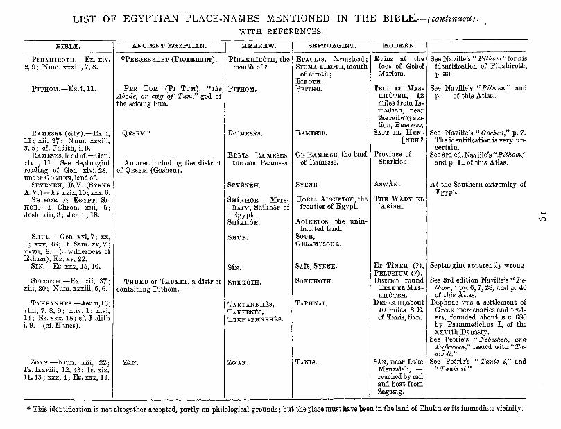
LIST OF EGYPTIAN PLACE-NAMES MENTIONED IN THE BlBL^.--(conhnuea^. WITH REFERENCES.
BIBLE.
PIHAHIEOTH.—Ex. xiv. 2, 9; Num. xxxiii, 7, 8.
PITHOM.—Ex. i, 11.
EAMESES (city).—Ex. i, 11; xii, 37; Num. xxxiii. 3 ,5 ; cf. Judith, i. 9.
EAMESES, land of .—Gen. xlvii, 11. See Septuagint reading of G-en. xlvi, 28, under GOSHEN, land of.
SEVENEH, E . V . (SYENE A.y.)—Ez.xxix, 10; xxx,6.
SHIHOE OF EGYPT, S I -HOE.—1 Chron. xiii, 5; Josh, xiii, 3 ; Jer. ii, 18.
SHUE.—Gen. xvi, 7; xx, 1; XXV, 18; 1 Sam. xv, 7 ; xxvii, 8. (= wilderness of Etham), Ex. xv, 22.
SIN.—Ez. xxx, 15,16.
SUCCOTH.—Ex. xii, 37; xiii, 20; Num. xxxiii, 5, 6.
TAHPANHES.—Jer.ii ,16; xliii, 7, 8, 9; xliv, 1; xlvi. M; Ez. xxx, 18; cf. Judith i, 9. (cf. Hanes).
ZOAN.—Num. xiii, 22; Ps. Ixxviii, 12, 43; Is. xix. 11,13; xxx, 4 ; Ez. xxx, 14.
ANCIENT EGYPTIAN.
^PEEQEEEHET (P IQEEEHET) .
P E E TUM ( P I T U M ) , "the Abode, or city of Turn,'' god of the setting Sun.
QESEM ?
An area including the district of QESEM (Goshen).
THUKU or THUKET, a district containing Pithom.
ZAN.
H E B R E W .
P I H A K H I E 6 T H , the mouth of ?
PITHOM.
EA'MESES.
EEETS EA'MESES, the land Eaamses.
SEVENEH.
S H I K H 6 E MITS-EAIM, Shtkh6r of Egypt.
S H I K H 6 E .
SHtE.
SIN.
SUKKOTH.
TAKPANKHES, TAKPENES, TEKHAPHNEHES.
ZO'AN.
S E P T U A G I N T .
EPAULIS, farmstead; STOMA EIEOTH, mouth
of eiroth; EIEOTH. PEITHO.
BAMESSE.
GE RAMESSE, the land of Eamesse.
SYENE.
HoEiA AIGUPTOU, the frontier of Egypt.
AoiKETOS, the uninhabited land.
SOUE, GELAMPSOUE,
SAIS, SYENE.
SOKKHOTH.
TAPHNAI.
TANIS.
MODERN.
Euins at the foot of Gebel Mariam.
TELL EL MAS-KHUTEH, 12 miles from Is-mailiah, near the railway station, Barneses.
SAET EL H E N -[ N E H ?
Province of Sharkieh.
ASWAN.
T H E W A D Y EL ' A E I S H .
E T T I N E H (?), PELUSIUM (?). District round
TELL EL MAS-KHIJTEH.
DEFENEH,ab0Ut 10 miles S.E. of Tanis, San.
SAN, near Lake Menzaleh, — reached by rail and boat from Zagazig.
See Naville's "Pithom"forhis identification of Pihahiroth, p. 30.
See Naville's "Pithom," and p. of this Atlas.
See Naville's " Goshen," p. 7. The identification is very uncertain.
See 3rd ed. Naville's "Pithom," and p. 11 of this Atlas.
At the Southern extremity of Egypt.
Septuagint apparently wrong.
See 3rd edition Naville's "Pithom," pp. 6, 7, 28, and p. 40 of this Atlas.
Da,phnae was a settlement of Greek mercenaries and traders, founded about B.C. 680 by Psammetichus I, of the xxvi th Dynasty.
See Petrie's " Nebesheh, and Defenneh," issued with "Tanis ii"
See Petrie's " Tanis i," and "Tanis ii."
vO
* This identification is not altogether accepted, partly on philological grounds; but the place must have been in the land of Thuku or its immediate vicinity.
20
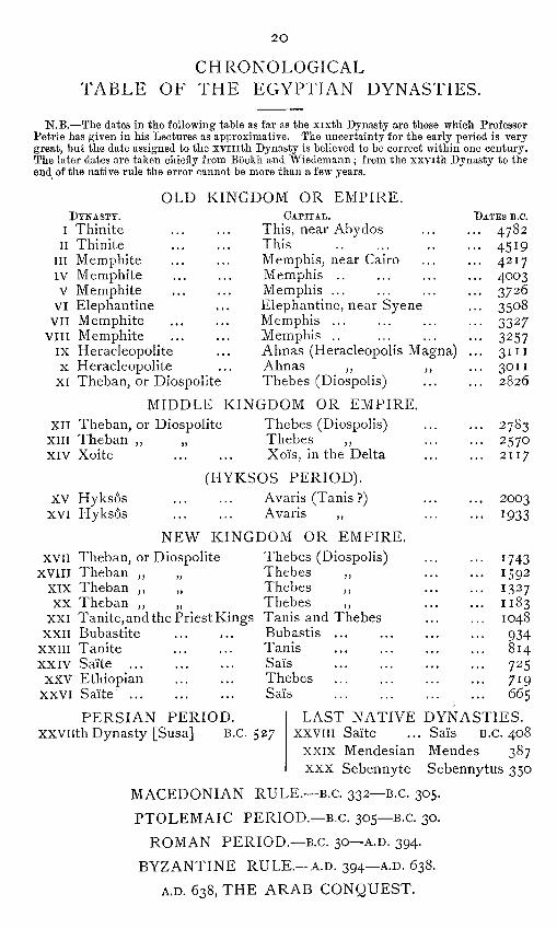
CHRONOLOGICAL TABLE OF THE EGYPTIAN DYNASTIES.
N.B.—The dates in the following table as far as the xixth Dynasty are those which Professor Petrie has given in his Lectures as approximative. The uncertainty for the early period is very great, but the date assigned to the xvi i i th Dynasty is believed to be correct within one century. The later dates are taken chiefly from Bockh and Wiedemann ; from the xxvith Dynasty to the end of the native rule the error cannot be more than a few years.
OLD KINGDOM OR EMPIRE. DYNASTY. CAPITAL. DATES B.C.
I Thinite ... ... This, near Abydos ... ... 4782 II Thinite This 4519
III Memphite ... ... Memphis^ near Cairo ... ... 4217 IV Memphite ... ... Memphis .. ... ... ... 4003 V Memphite ... ... Memphis ... ... ... ... 3726
VI Elephantine ... Elephantine, near Syene ... 3508 VII Memphite ... ... Memphis ... ... ... ... 3327
VIII Memphite ... ... Memphis .. ... ... ... 3257 IX Heracleopolite ... Ahnas (Heracleopolis Magna) ... 3111 X Heracleopolite ... Ahnas ,, ,, ... 3011
XI Theban, or Diospolite Thebes (Diospolis) ... ... 2826
MIDDLE KINGDOM OR EMPIRE. XII Theban, or Diospolite Thebes (Diospolis) ... ... 2783
XIII Theban ,, „ Thebes ,, ... ... 2570 XIV Xoite ... ... Xois, in the Delta ... ... 2117
(HYKSOS PERIOD). XV Hyksos Avaris (Tanis ?) 2003
XVI Hyksos Avaris ,, 1933
NEW KINGDOM OR EMPIRE. XVII Theban, or Diospolite Thebes (Diospolis) ... ... 1743
XVIII Theban ,, „ Thebes ,, 1592 XIX Theban ,, „ Thebes ,, 1327 XX Theban ,, „ Thebes ,, 1183
XXI Tanite, and the Priest Kings Tanis and Thebes ... ... 1048 XXII Bubastite ... ... Bubastis ... ... ... ... 934
XXIII Tanite ... ... Tanis ... ... ... ... 814 XXIV Saite Sai's 725
XXV Ethiopian ... ... Thebes ... ... ... ... 719 XXVI Sa"ite Sai's 665
PERSIAN PERIOD. XXVllth Dynasty [Susa] B.C. 527
LAST NATIVE DYNASTIES. XXVIII Sai'te ... Sai's B.C. 408
XXIX Mendesian Mendes 387
XXX Sebennyte Sebennytus 350
MACEDONIAN RULE.—B.C. 332—B.C. 305.
PTOLEMAIC PERIOD.—B.C. 305—B.C. 30.
ROMAN PERIOD.—B.C. 30—A.D. 394.
BYZANTINE RULE.—A.D. 394—A.D. 638.
A.D. 638, T H E ARAB CONQUEST.
21
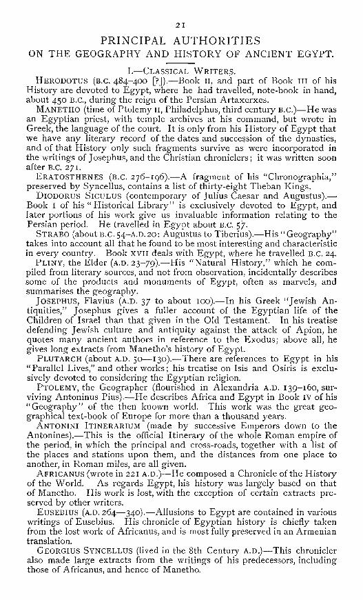
PRINCIPAL AUTHORITIES ON T H E GEOGRAPHY AND HISTORY OF ANCIENT EGYPT.
L—CLASSICAL W R I T E R S . HERODOTUS (B.C. 484-400 [?]).—Book 11, and part of Book ill of his
History are devoted to Egypt, where he had travelled, note-book in hand, about 450 B.C., during the reign of the Persian Artaxerxes.
M A N E T H O (time of Ptolemy ll, Philadelphus, third century B.C.)—He was an Egyptian priest, with temple archives at his command, but wrote in Greek, the language of the court. It is only from his History of Egypt that we have any literary record of the dates and succession of the dynasties, and of that History only such fragments survive as were incorporated in the writings of Josephus, and the Christian chroniclers; it was written soon after B.C. 271.
ERATOSTHENES (B.C. 276-196).—A fragment of his "Chronographia,'' preserved by Syncellus, contains a list of thirty-eight Theban Kings.
DiODORUS SiCULUS (contemporary of Julius Caesar and Augustus).— Book I of his "Historical Library'' is exclusively devoted to Egypt, and later portions of his work give us invaluable information relating to the Persian period. He travelled in Egypt about B.C. 57.
STRABO (about B.C.54-A.D.20: Augustus to Tiberius).—His ^'Geography^^ takes into account all that he found to be most interesting and characteristic in every country. Book XVII deals with Egypt, where he travelled B.C. 24.
PLINY, the Elder (A.D. 23-79).—-His ''Natural History/ ' which he compiled from literary sources, and not from observation, incidentally describes some of the products and monuments of Egypt, often as marvels, and summarises the geography.
JOSEPHUS, Flavius (A.D. 37 to about 100).—In his Greek ^'Jewish Antiquities," Josephus gives a fuller account of the Egyptian life of the Children of Israel than that given in the Old Testament. In his treatise defending Jewish culture and antiquity against the attack of Apion, he quotes many ancient authors in reference to the Exodus; above all, he gives long extracts from Manetho's history of Egypt.
PLUTARCH (about A.D. 50—130).—There are references to Egypt in his "Parallel Lives," and other works; his treatise on Isis and Osiris is exclusively devoted to considering the Egyptian religion.
PTOLEMY, the Geographer (flourished in Alexandria A.D. 139-160, surviving Antoninus Pius).—He describes Africa and Egypt in Book IV of his "Geography" of the then known world. This work was the great geographical text-book of Europe for more than a thousand years.
ANTONINI ITINERARIUM (made by successive Emperors down to the Antonines).—This is the official Itinerary of the whole Roman empire of the period, in which the principal and cross-roads, together with a list of the places and stations upon them, and the distances from one place to another, in Roman miles, are all given.
AFRICANUS (wrote in 221 A.D.)—He composed a Chronicle of the History of the World. As regards Egypt, his history was largely based on that of Manetho. His work is lost, with the exception of certain extracts preserved by other writers.
EUSEBIUS (A.D. 264—340).—Allusions to Egypt are contained in various writings of Eusebius. His chronicle of Egyptian history is chiefly taken from the lost work of Africanus, and is most fully preserved in an Armenian translation.
GEORGIUS SYNCELLUS (lived in the 8th Century A.D.)—This chronicler also made large extracts from the writings of his predecessors, including those of Africanus, and hence of Manetho.
22
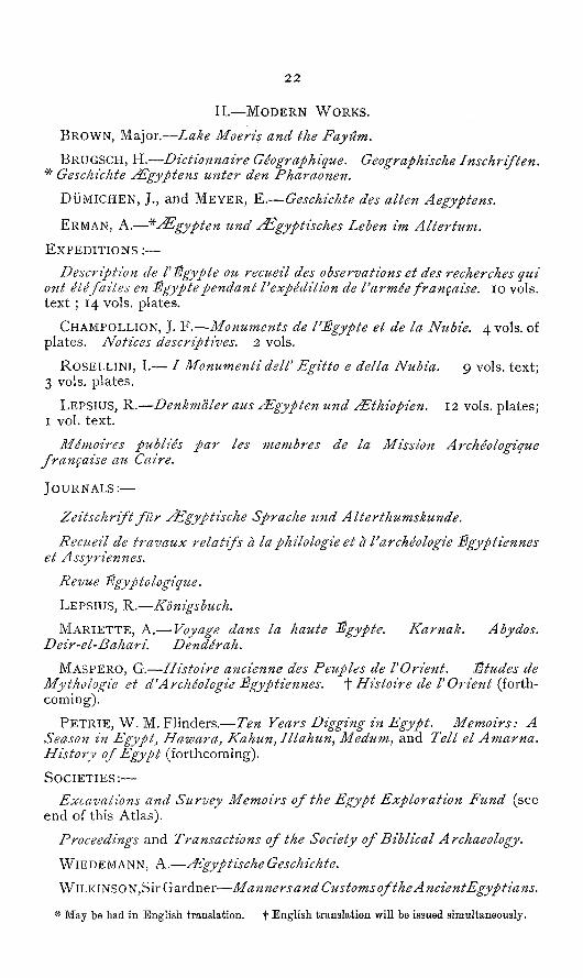
I I . — M O D E R N W O R K S .
BROWN, Major.—Lake Moeris and the Fayitm.
BRUGSCH, H.—Dictionnaire Geographique. Geographische Inschriften. ^ Geschichte ^gyptens unter den Pharaonen.
DiJMlCHEN, J., and MEYER, E.—Geschichte des alien Aegyptens.
ERMAN, A . — ^ ^ g y p t e n und ^gyptisches Leben im Altertum.
E X P E D I T I O N S :—
Description de V^gypte ou recueil des observations et des recherches qui ont etefaites en lEgyptependant Vexpedition de Varmee frangaise. lo vols, tex t ; 14 vols, plates.
CHAMPOLLION, J. F.—Monuments de I'Egypte et de la Nubie. 4 vols, of plates. Notices descriptives. 2 vols.
ROSELLINI, I.— / Monumenti deir Egitto e delta Nubia. 9 vols, text; 3 vols, plates.
LEPSIUS, R.—Denkmaler aus j^gypten und ^thiopien. 12 vols, plates; I vol. text.
Memoires publics par les membres de la Mission Archeologique frangaise au Caire.
J O U R N A L S : —
Zeitschrift fur ^gyptische Sprache und Alterthumskunde.
Recueil de travaux relatifs a laphilologie et a Varcheologie Sgyptiennes et Assyriennes.
Revue ^gyptologique,
LEPSIUS, R.—Kdnigsbuch.
MARIETTE, A . — Voyage dans la haute JSgypte. Karnak. Abydos. Deir-el-Bahari. Denderah.
MASPERO, G.—Histoire ancienne des Peuples de VOrient. JEtudes de Mythologie et d'Archeologie ^gyptiennes. t Histoire de POrie?it (forthcoming).
P E T R I E , W . M . Flinders.—Ten Years Digging in Egypt. Memoirs: A Season in Egyptj Hawara^ Kahun, Illahun, Medum, and Tell el Amarna. History of Egypt (forthcoming).
S O C I E T I E S : —
Excavations and Survey Memoirs of the Egypt Exploration Fund (see end of this Atlas).
Proceedings and Transactions of the Society of Biblical Archaeology.
WIEDEMANN, A.—^EgyptischeGeschichte.
WILKINSON,Sir Gardner—Manners and Customs of the AncientEgyptians.
* May be had in English translation. f English translation will he issued simultaneously.
20 A.
G E N E R A L MAP OF A N C I E N T EGYPT
WITH
ADJACENT COUNTRIES.
B 30** C 35" D 40° E F 50

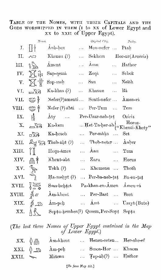
TABLE OF THE NOMES, WITH THEIR CAPITALS AND THE GODS WORSHIPPED IN THEM (I to xx of Lower Egypt and
XX to XXII of Upper Egypt).
Noma
I .
I I .
I I I .
IV.
V.
VI.
VI I .
VI I I .
IX.
X.
XT.
XII .
XI I I .
XIV.
XV.
XVI.
XVII .
XVIII.
XIX.
XX.
Anb-hez
/f€::i V Kliensu (r
Ament
Sap-qema
Sap-meh
Ka-klias (?)
OopHal City,
Men-nefer
Sekhem
A mil
Zeqa
Sau
Kliasuii
f
II if
^
Nefer(?)amenti... Senti-nefer ..
Nefer (?) abti ... Per-Tum
Aty ... Per-Usar-neb-tet
Ka-kem ... Het-Ta-her-ab
Ka-lieseb
Theb-aht (?)
Heqa-ames
Khent-abt
Tekh (?)
Ha-mehyt (?)
Sma-behtet
Am-khent
Am-peh
Deity.
. Ptali
PIor-ur(Aroeris)
Hatlior
. Sebek
. Neitli
. Ra
Amen-ra
Tum
Osiris Horus-
Khenti-Khety" Set Per-maka
Theb-neter
Anu
Zaru
Kliemenu
Per-ba-neb-tat Ba-en-tat
Pa-kben-en-Amen Amen-ra
... Per-Bast ... Bast
... Amt ... Uazyt(Buto)
Anher
Tum
Horus
Thoth
A R^ Septu-kemhes(?) Qesem,Per-Sopt Septu
[The last three Nomes of Upper Egyf)^ contained in the Ma^j of Loioer Egypt.)
XX.
XXI.
XXII.
m 0 ^ "'^^
Am-khent
Am-peh
Matenu
Henen-seteu...
Smen-Hor ...
... Tep-ah(?) ...
face Maxo HI.']
Her-she-ef
Khnem
Hathor

A
i i v j y i ' 1
e C-"
M E D I I T i U R X N E A N S E A
t , l l - '' « f / io
LT'j^^~o?~n:i-
, C3:ble ^ V
^ L e 3 : ^ .
^ \
52u avuteKk JBeLS t);jJ
'^^fiow
' H 'o/r t^^^
^ V ' ^ , T^* ^ > ; / 4<^-^
E l . ^ ^ BTrf-tfe
l -
lly,
25
20
?L
2 5 -
n w i]i-S o
typiCHah
H Y'n k Jhft. V *^ t l
i i t i >^.y.i/v i .
y^c::) V . n J / 1 ^ ^ ^ ^ ^ 7 / 11 y /
,,^^ 'Sariy
jg!!^J^il^fe^^ /
W a k e i -Dal rhe l /<?/• Ifesteiij Ocuvis!
d o ^ ^ '
r^-
7 ' / ' t> p I 0 o f
S a 77 d h i I}!.9 ffa7n,ui0i^^li9<^'<t
/r ft bi^'C 7 4 i i I JiByJ^sSm
/ > , J I F h^Sf-M.
"IMfiihcL y-owfih
SKETCH
SHOWING THE PRINCIPAL GEOLOGICAL FEATURES
OF EGYPT AND NUBiA
W^^o,
' •^H
/ V
Alluvium • • ' H S U Limestone , p—| Sandstone r—i Crystalline Rocks WK
S
. (^^ ^ ' ' S ^ V ' - ^ ^ ^ -
• Ra^Beeban
\Me.nya MuhuTilc
\ Palinurits R +
^onr I
25
Shi^'
Shenn Uraikh ah^
ShahJibxo TenderdK
>Ea^ Ju-si^eah
SJutrmj Abu
J e b e L S o t e x b a
WeSm
G E N B R A I J M A P O F M O D E R N EGYP ' JP
AND
ADJACENT GODNTRIES.
Desert Cultivated land and
pasturage
SCALE OF MILES
a
20
^
15
wW '
B I) E F

MAP OF A N C I E N T EGYPT.
C


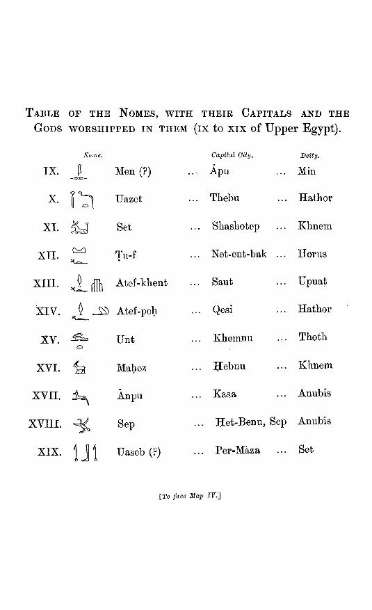
TABLE OF THE NOMES, WITH THEIR CAPITALS AND THE
GODS WORSHIPPED IN THEM (IX to xix of Upper Egypt).
Nome
IX. P Men (?) -<50J>-
X. I ^ Uazet
XI. ^ Set
XII. ^ Tu-f
XIII. J__ ffHi Atef-khent
XIV. J _ - ^ Atef-peh
XV. ^ Unt
XVI. ^ Mahez
XVII. ±^ Anpu
XVIII. ^ Sep
XIX. I J I IJaseb(?)
Capital Oity.
Apu
Thebu
Shashotep
Net-ent-bak ..
Saut
Qesi
Khemnu
Hebnu
Kasa
Deity.
. Min
.. Hathor
Khnem
,. Horus
.. Upuat
.. Hathor
.. Thoth
.. Khnem
.. Anubis
Het-Benu, Sep Anubis
Per-Maza Set
[To face Map IF.]
MAP OF A N C I E N T EGYPT.
A B
30*^
PER-ci8lA2A XKl. OXYflHYNCUS
KASA / XKILCTOOPOLISS X .
BBBMIOPOLIS TVrAfyT JA ^ JEsTimxareiX'M
• ^
^
ip
^
^ - . ^
T H E B U X.AeHHUIIITOPOIXS
•Lonjjitgde E a s t 31° o f Greertwich..
B
BENI SUEF TO EKHMIM.

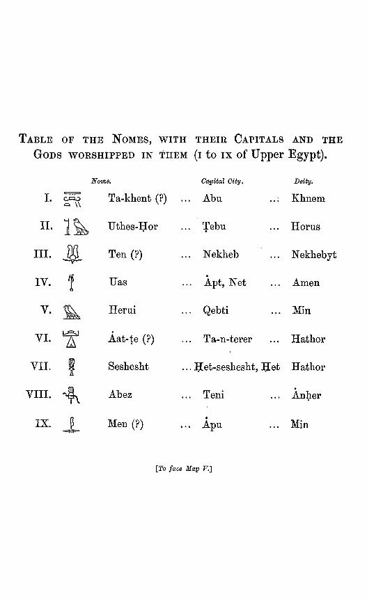
TABLE OF THE NOMES, WITH THEIR CAPITALS AND THE
GODS WORSHIPPED IN THEM (I to ix of Upper Egypt).
I.
II .
III.
IV.
^ W
1& M-
f
Nome,
Ta-khent (?) .
Uthes-Hor
Ten (?)
Uas
Capital City,
.. Abu
.. Tebu
.. Nekheb
.. Apt, Net
Deity,
,.; Khnem
... Horus
... Nekhebyt
... Amen
V- Herui Qebti ... Min
VI.
VII.
VIII.
IX.
¥ 1 A
p
Aat-te (?)
Seshesht
Abez
Men (?)
[To
... Ta-n-terer
... Het-sesheshi
... Teni
• ... Apu
face Map F.]
Hathor
Anher
... Min

M A P O F A N C I E N T EGYPT. V.
A P U " . LPANOEOIilS
\ TENI VJg THIS
ABTU \ ^
^
4' <i>
feHEKOBOSKION
HET-SESHESf vn,,;j),iQ!s,|'.o,ysP4^v^-.
•--.-•"••• ftvu
31
2 5 -
<'o / >•? '
\ f"^ / i
%./ '"'"^•"" i 1 \ s '""''" .---" , , i '-^^ **" / 5
1 '^'^^IKhucrc^eh >
) / 'i .-' J^ •f f o \
5 1 /
\ / f \ I ^'^ ^ 0 o.> - -^ ,' S
^ 1 x'
I I \ £- ! % 1
'SlBeTzs p \^ /
/ 1* i
i \ oDtish/ elKhl'eJv / ( / \ t
MMaksd ^"'\
1 1
OJ QEBTI eYXOPTO^
D e r eUBahri
NETKO-IV. T H E
A N U - Q E M A : ANU-M^NTD / ^ ^ - P ^ ^
S-SHE-EN-..,
J -JyiATU
31
t ixser (llajTUTicuriaJ>JBi^)
ANTl Grebelm, V
HET-StFE
A N Y T I S E N I l A T C ^ O H S l
NEKHEN:PER-KEMH£S(?): HIEHACOSPOIiK^ V : $ ^
TEBU I I APOLL1NOPQ1.IS MAGyrA^j
SaadLStonx, Qnarriesi
GeheL
O A S I S OF E L K H A R G E H .
ABU I ELEPHANTINE
etztret ez ZaMft]
Tamb(
SENEMT mgeh\
^
^
v>>
NEKHEB ilTHYMPOIilS
^^^
NUBVT 6 ^ B O S
SUNT y^'^YBlSE SEVENEH
• Aswan' ^rcmitsQuxxrvies >U A REQ: PHILAE
LoTtj^itnAe E a s t 32^ o f GreeTUwich-
E K H M I M TO P H I L A E .

M A P O F E T H I O P I A . VI.
ASWAN TO S E M N E H .

MAP OF E T H I O P I A .
B C
VII.
D
B C S E M N E H T O KHARTUM.

VIII.

INDEX TO MAP OF MODERN EGYPT, No. II.
Ababdeh, D g-h Abadeh,C g Abd el Hab (Kokreb), E g Abkor, C g Aboody, C f Aboukir, C a
(b) C a Absari, G f Absol, D g Abtin, D g Abu Ahmed, D g
„ Bellah (1.), C b ,, Burra (well), C h ,, Darah, E e „ Delek, D h ,, Dis, D g „ Dom, C g n Egb, D g ,, ez Zusar, D i ,, Fatmeh, C g ,, Gerad, C i „ „ C h ,, Girgeh, 0 c ,, Grusi, C g „ Haifa (wells), D g ,, Haraz, D i ,, Hashim, D g ,, Hereji, D e ,, Hor, D e ,, J ez Zega. „ Klea (wells), D h ,, Koloda, E g ,, Mohary, B c „ Nub, D h „ Odfa, D g ,, Saghara, B c ,, Said, C e ,, Samud, C h ,, Shaar (Myos Hermos), D d ,, Shar, D c „ Sher, D g „ Seiyal, C h „ Syale, D h
Abut, D i Abutaki, B b Abutingil, 0 e Abu Usher, C h Acre (or Akka) D a
Adda, 0 f Addereworri, E h Aden Ammam, D g Adiabo, F i Afat, C g Agahl, E h Agayl, E i Aghig (mt.), E g Ain Abu Suwekah, D c
,, Amur, C d ,, el Haderah, D c ,, el Kuden^at, D b „ el Sheb, B e ,, elWeibe, E b ,, Hamid, B h ,, Hawara, D c „ Kelid, B e
Akaba (gulf), D c Akaba, E c Akaba el Benat, C f Akabah esh Shamiyeh, E c Akabah Zumameh, D g Akash, C f Akeeg, C d Akka (Acre), E a Akra, E d Alem el Halfi, B b Al Engreyah, D g Alexandria, B b Algeden, E h Algueib, D g Allataksora (mt.), E i Amadib, F h Amandar, C g Ambigole (cat.), C f Ambub, C d Ambukal, C g Amet, E g Amka, C f Amman, E b Ammara, C f Ammarsheem, C e Amri (wells), C h Amur, n g AnaguUe, F i Angash (Wady Haifa), C f Aniba, C e Annak, D e
Angusab, C f Arabian desert, C D c d Arab's Gulf, B b
„ Tower, B b Ard Jiddar, E c Argab Teshagoa (desert), C { Argeyn, C f Argo and I, 0 g Ariab, E g Arkhab, C i Asfoun, D d Asgade, F i Ashrafi, I., D c Askalan, D c Asrafi, L, D c Assanaga (well), D g Asses Ears, E c Assouan, D e Assur, D h Atbara, E h Atbara (r), E h-i Atfeh, C c Atireh, C f Atmoor (desert), D f Atmun, D g Ayina, E c Ayoun, D c Azidei, E h
Baaluk, E h Baga, D h Bahak (cat.), C g Bahiri (Lower Egypt), C b Bahneseh, C c Bahr Attab Arrelan, D f Bahr bela Ma, B b-c-d
„ „ ., Df Baidib, E f Bakri, C g Balat, B d Banaghir, E h Baraka, E F h Barango, J) i Bardi (i), C g Bardowal (1), D b Barea, F h Bareedy (c), E e Bar el Hadjar, C f
INDEX TO MAP OF MODERN EGYPT.
Barud, E g Baslein, C g Batn el Hajar, C f Bayuda (well), C h
(steppe), C h ,, (desert), D g
Bazeh, E i Bedareh, C d Bedshem, D g Beillany, C f Beisan, E a Beit el Gawa, C g Belagenda, F h Belbeis, G b Bender el Keber, D e Beni Hasan, G c
„ Kafa, C d Benisouef, C c Benneh, G g Ben Naga, D h Berab, D i Berber, D g
„ D g Berenice (ruins), E e Berfedu, F i Beris, C e Bermin, C c Bersheh, G c Bettera, E c Bir, D f
,, Abu Karaet, D g Birbe, D e Bir Darfaooi, D d
,, el Mashiyah, D c ,, elNabeh, Df ,, es Seb, D b ,, Shamael, D g
Birket el Haj, C b ,, Kurun, G c ., Temseh, C b
Bir Nauarik, D g ,, Sarniyeh, C g „ Sreb, D d
Birti, C g Bisagra, I) h Bisha, F h Bisharen (desert), D e Bitter Lakes, G b Borgadeh, G g Bostan, G f Bourlos (1), G b Brothers (i), D d Brumbel, G c Bulak, G d Bulu el Argol, C d Burkat (i), F g
Gairo, G b Carmel (mt.), D a Geiga, D f
Ghangur, G h Gheli, D h Chime, D c Coorcoor (oasis), G c Gosseir, D d Cosseir, Old (Philotera), D d
Dabab, E h Dabba, T> i Daga, E h Dahal, D c Dakkeh, D e Daksheleh, D g Dal, G f Damanhoor, G b Dameur, or Nafadik, D g Damietta, C b Dar el Mughr, F c Dar Halfiyeh, D h Darkein, E d Darmout, D e Dashoor, G c Dead Sea, E b Debbee Sale, F h Debbeh, G g Debod, D e Defar, G g Degwig Eagd, G i Dehmir, D e Deiroot esh Sherif, G d Delligo, G f Delta, the, C b Denderah, D d Dendur, D e Derr, G e Derrer, D h Desoor, D d Diggo, F h Dongola (North), C g
„ (Old), G g Doosh, G e Dougiyet, G g Dra, B d Duderdabb, E f Dungum (spring), G e Dunkuaz, E h
Ebar, G f Ebret, E h Ebsamboul (Abu Simbel), G f Ed Damar, D g Ed Dubbah (wells), G h Ed Dugim, D i Edermih (cat.), C g Edfou, D e Egarin, D i Ekhmin, G d El Abaca. D h „ Abdeh, D b ,, Abeidieh, D g
El Abid, G c „ Adek, G i
Elag (wells), G h El Agel, E c ,, Akaba, G d „ Aliab, D h ,, Amra, C i ,, Arak, G g ,, Arish, D b ,, Bagara, D g ,, Beda, E d
Elbeh (i.), E f „ (mts.), E f
El Belka, E b ,, Bescum, E h ,, Betish, G d „ Bum, C h ,, Busaireh, E b „ Egedeh, D h
Elephantine (i), D e El Fasher, E h ,, Fekyibrahim, D i ,, Fokari, F d ,, Gezir, G d ,, Gimmez, D g ,, Gindi, E h „ Goz (wells), C h ,, Gwa, C i ,, Gwernaiah, G i ,, Hadeida, G c ,, Hadgir, D h ,, Hagra, E h ,, Hareib, G d ,, Harreyry, F d ,, Hassa, D g ,, Hegera, E i ,, Haimar (well), D e ,, Helba, C i ,, Helleh, D d „ Hibeh, D d ,, Hiss, E f ,, Houra, E d ,, Howarte, G c ,, Howeiyat, G g ,, Hubagwi, G h ,, Jau, F a ,, Jindel, B d ,, Ka'a, E c „ Kab, D d „ „ B g ,, Kabur, G g ,, Kalabsheh, D e ,, Kalas, G g ,, Kantara, C b ,, Kasan, D e ,, Kasr, B d ,, ,. B e ,, Kersh, C d ,, Kharjeh, G d ,, Khulasah, D b
INDEX TO MAP OF MODEEN E G Y P T .
El Khulit, E b ,, Kirbekan, C g ,, Koweh, D i ,, Kudrowab, D g ,, Kuds (Jerusalem), E b ,, Kur, G g ,, Kurum, D g ,, Manawi, D g „ Mashitah, E b ,, Mek, D h „ Melchat, F b ,, Menawi, D g ,, Menshieh, G d ,, Metzareib, E a ,, Motmar, G d „ Mues, D g ,, Ordeh (N Dongola), G g ,, Sonane, E h ,, Sugaleb, E h „ Uk, D i ,, Wasta, G d
Em Matre, E g ,, Mogran, D g
Ensheyfa, F d Eresais, D c Erment, D d Er Eih, E b Er Rumi, F b Esdood, D b Eshetabah, D h Eshmunein, G c Esh Shoona (Leucos Portus), D d Esneh, D d Es Safiyeh (wells), G h E'Sh'habboo, F d Es Salayieh, D i ,, Saribe, G h ,, Sueimanieh, D g
Etsrah, F b Et Tih, D h ,, Turiab, D i
Eynunah, E c Ezrak, E b
Fadasi, D i Faioum (the), C c Fakirkir, D i Farafreh, B d Farass, D e Fariad (i), G g Farmundi, G f Farshoot, G d Fateereh, D d Fayab, G g Feiran, D c Ferket, G f Feshn, C c Filik, E h Foul Bay, E e
Gabra, G i Gabra (wells), G h Gakdul (wells), D g Galakla, D h Gallaweeh, G d Gamba (wells), G h Garderamak, B c Gar en Nebi, D h Garnata, D g Gau el Kebir, G d Gaza, D b Gedia, D h Gerad, C h Gerada, D i Gerashab, D h Gerazeh, D i Gereyiy E c Gerfedu, F i Gergaf, E i Gertod, G g Ghatta (bay), B b Ghizeh, G b Gienneh, G d * Gilif (desert), D g Girgeh, G d Girri, E i Girshe, D e Golhan (i), E e Goorgote, C f Goorti, G f Gos Eedjeb, E h Guba, D h Gubata Awara, B c Gueyra, B c Guiren Tawa, G f Gulfah, D h Gurkab, D h Gurneh, D d Gutaba, D g Gurzael el Quez, D h
Habsai, E i Hadanet, E h Hagar (plateau), F h Hagona, G i Haj (Egtn. route), D E E c-d-(
„ F d Hakl, D c Half aha, G e Halfiyeh, D h Hamadun, D e Hamdal, E h Hamdun, D i Hammadiyah (wells), G h Handak, G g Handub, E g Hannak, G g Hannek, G g
n C g Haou, G d
Harrat el Khuturra, F d Harrat e' Sydenyin, E c Harrat Moahit, F d Hasabala, E i Hassanee (i), E e Hawaia, D h Hellet, D h Hemenar, G g Hesban, E b Hormareb, D g Hudeibah, F e
Ibrim, C e Id Nibeg, G i Igadeh, G g lizeam, G c Iran, G f Ismailia, G b Itfu, C d
Jaffa, D b Jaffatine (i), D d Jara, B d Jebel Adraneb, G f
,, Agagemab, D f ,, Ain, B h ,, Ajlo"n, E b ,, Anaz, F d ,, Araif en Nakah, D b ,, Asma, D g ,, Ataka, C c ,, Bakutueb, E h ,, Baran, D e ,, Bisbish, D f „ Gheki, D h ,, Dokhan, D d ,, el Abia, G h „ Elag, G h ,, elErefah, G h ,, el Hagr, D h ,, elTyh, D c ,, elTyh, D c ,, Erefah, C h ,, Erkowit, E g „ es Sofiyeh, D h ,, Eynunah, E c ,, ez Zega, G g ,, ez Zeit, D c ,, Ferageh, D e ,, Garab, D c ,, Gehdar, E h ,, Gharib, D c ,, Gurrat, E g ,, Hallat Ammur, E ,, Hauran, E a ,, Hawi, G h „ Helal, D b ,, Hummam, D c ,, Jowla, E d ,, Katerin, D c
INDEX TO MAP OF MODERN E G Y P T .
Jebel Kissere, D g ,, Kufrah, D c ,, KulgeH, G g „ Kureb, E h ,, Mandera, C f ,, Masrura, G i ,, Memfayah, D d ,, Merzum, F d ,, Miama, F b ,, Mousa, D c ,, Muksheib, D b ,, Murhat el Mora, G f ,, Musmar, E g ,, Ojnieh, D c ,, Owdum, G h ,, Paraseh, F h „ Reft, G f ,, Rosas, D d ,, Sakhar, G d „ Salakh, E f ,, Sehteb, E g ,, Serbal, D c ,, Sherrara, F c „ Shigre, D f ,, SilsiH, D e ,, Sohaunit, D f ,, Soterba, E f ,, Sotirba, E g ,, Suam, G d ,, Tayibal Ism, E c ,, Tenasep, G c ,, Tobeyk, F c ,, Tuenai, E g „ XJriba, E g ,, Wady Lehnma, D e „ Witter, F d ,, Yob, E h ,, Zobara, D e
Jelall, B c J crash, E b Jerin el Ful, G d Jerizet W. Jemal (i), E e Jerusalem, E b Jiora (spring), D g Jordan (r), E a-b Jubal (i), D c
Kababish, G h Kabati, D h Kabenat (cat.), C g Kabushi, D h Kadd Dhaba, E c Kaf, F b Kafr Khab, D d Kagmar, G i Kaibar, G g Kaibub, G i Kaisariyeh, D a Kalaat Ajroud, G b Kalabab, E h
Kalat el Hessy, E b Kalat el Belka, E b Kalat en Nakhl, D c Kalat Medawara, E c Kamgal, D g Kamlin, D i Kandjar, D h Karaken, G f Karanak, D i Kardaseh, D e Karkabat, E h Karnak, D d Kasbia, D i Kash (wells), D d Kasinkar, G g Kasr Ahmed, D d
el Akhdar, F c el Lebekh, G d Ezrak, E b Kerun, G c Zerka, E b
Kassaba (wells), G e Kassala, E h Katieh, D b Kauwumi, G d Kazeroon (c), D b Kednet, F h Keneineitah, D g Kenneh (old), D d Kenneh, D d Kenur, D g Kerak, E b Kerreri, D h Kez Zaraf, G h Khan Yunas, D b Khartum, D h Khor Abdum, C g
,, Abu Herud, G g ,, Abu Kashim, G h „ AH, E h ,, Anseba, E h ,, Aradaeb, E h ,, Baraka, E g ,, elAbuKuk, Gh ,, el Brega, C h „ el Erefah, C h „ el Gash, E h ,, el Laban, D h ,, el Oalaz, E i ,, el Wabari, G h ,, ez Zaraf, G h ,, Fagedel, E h ,, Gergaf, E i ,, Hambut, E h ,, Harabsoid, E h ,, Hassanawi, G h ,, Kashmil, E i ,, Mamam, E h ,, Mesalami, E i ,, Omadeh, F g
Khor Omrahid, E i ,, Sawa, E h „ Tagel, E h
Khutraneh, E b Kirba, E i Kobban,D e Kodokol, G g Koft, D d Kokan, D e Koom Ombo, D e Korasi, E h Korkas (i), D g Korosko, G e Korrobi, D g Korti, G g Korti, D e Kous, D d Koye, G f Kreder, E i Kubaneeh, D e Kubishi, D g Kueh, D d Kufit, F h Kufriat (wells), C g Kunawat, E a Kurukol, C g Kus Abu Deluah, G h Kuskus, G g Kutraneh, E b
Lahaiwa, C d Libyan desert, B-G b-c-d-( Lud, D b Luxor, D d
Maan, E b Maatuk, D i Macour (i), E e Macowa (i), E f Madik, G f Magaga, D g Maharakat, E i Maharroka, D e Mahass, G f Mahatepe, F i Mahtul (wells), C g Mais, E g Makafab, E f Makhgar, D d Makhmudieh, D h Maleki, G e Manakil, D i Manfaloot, G d Mankabat, G d Mansora, G d Mansurah, G b Mansurieh (i), D e Marabut, B b Mardunah (i), E d Marea, F h
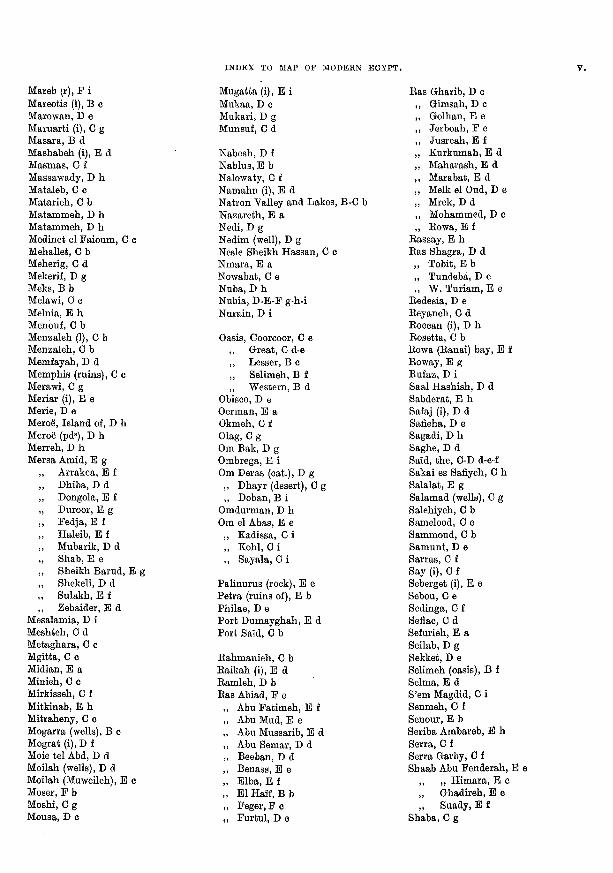
INDEX TO MAP OF MODERN E G Y P T .
Mareb (r), F i Mareotis (1), B c Marowan, D e Maruarti (i), G g Masara, B d Mashabeh (i), E d Masmas, 0 f Massawady, D h Mataleb, G c Matarieh, C b Matammeh, D h Matammeh, D h Medinet el Faioum, C c Mehallet, C b Meherig, C d Mekerif, D g Meks, B b Melawi, G c Melnia, E h Menouf, G b Menzaleh (1), G b Menzaleh, G b Memfayah, D d Memphis (ruins), C c Merawi, G g Meriar (i), E e Merie, D e Meroe, Island of, D h Meroe (pd^), D h Merreh, D h Mersa Amid, E g
Arrakea, E f Dhiba, D d Dongola, E f Duroor, E g Fedja, E f Haleib, E f Mubarik, D d Shab, E e Sheikh Barud, E g Shekeli, D d Sulakh, E f Zebaider, E d
Mesalamia, D i Meshteh, G d Metaghara, G c Mgitta, G 0 Midian, E a Minieh, G c Mirkisseh, G f Mitkinab, E h Mitraheny, C c Mogarra (wells), B c Mograt (i),D f Moie tel Abd, D d Moilah (wells), D d Moilah (Muweileh), E c Moser, F b Moshi, G g Mousa, D c
Mugatta (i), E i Mukaa, D c Mukari, D g Munsuf, G d
Nabesh, D f Nablus, E b Nalowaty, G f Namahn (i), E d Natron Valley and Lakes, B-G b Nazareth, E a Nedi, D g Nedim (well), D g Nesle Sheikh Hassan, C c Nmara, E a Nowabat, C e Nuba, D h Nubia, D-E-F g-h-i Nurain, D i
Oasis, Coorcoor, G e ,, Great, G d-e ,, Lesser, B c „ Selimeh, B f ,, Western, B d
Obisco, D e German, E a Okmeh, C f Olag, G g Om Bak, D g Ombrega, E i Om Deras (cat.), D g ,, Dhayr (desert), C g ,, Doban, B i
Omdurman, D h Om el Abas, E e
,, Kadissa, C i „ Kohl, G i ,, Sayala, C i
Palinurus (rock), E e Petra (ruins of), E b Philae, D e Port Dumayghah, E d Port Said, C b
Rahmanieh, G b Raikah (i), E d Ramleh, D b Ras Abiad, F e
Abu Fatimeh, E f Abu Mud, E e Abu Mussarib, E d Abu Semar, D d Beeban, D d Benass, E e Elba, E f El Half, B b Feger, F o Furtul, D c
Ras Gharib, D c Gimsah, D c Golhan, E e Jerboah, F e Jusreah, E f Kurkumah, E d Maharash, E d Marabat, B d Melk el Oud, D e Mrek, D d Mohammed, D c Rowa, E f
Rassay, E h Ras Shagra, D d „ Tobit, E b ,, Tundeba, D e „ W. Turiam, E e
Redesia, D e Reyaneh, C d Roccan (i), D h Rosetta, G b Rowa (Ranai) bay, E f Roway, E g Rufaz, D i Saal Hashish, D d Sabderat, E h Safaj (i), D d Safieha, D e
di, D h be, D d
Said, the, C-D d-e-f Sakai es Safiyeh, G h Salalat, E g Salamad (wells), G g Salehiyeh, C b Samelood, C c Sammoud, C b Samunt, D e Sarras, C f Say (i), G f Seberget (i), E e Sebou, C e Sedinga, G f Sefiac, G d Sefurieh, E a Seilab, D g Sekket, D e Selimeh (oasis), B f Selma, E d S'em Magdid, C i Senmeh, 0 f Senour, B b Seriba Ambareb, E h Serra, C f Serra Garby, C f Shaab Abu Fenderah, B e
,, ,, Himara, E e ,, Ghadireh, E e „ Suady, E f
Shaba, C g
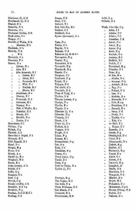
INDEX TO MAP OF MODEBN E G Y P T .
Shadwan (i), D d Shaibarah (i), E d Shaluf, D b Shamba, D h Sharona, G c Shebacat (wells), D h Sheb Alun, G e Shegat, C i Sheikh el Walia, D h
,, Hassan, D h Sheikieh, D h Shendy, D h
n D h Sherafeh, C c Shererat, F c Sherm, D c
Abban,B e Abu. B f Abu Amarah, E f
„ Datek, E f „ Ghat, E f ,, Jeseireh, E f „ Med, B e „ Nehleh, E f „ Shora, E f
Braikhah, F e Charar, E f Demerah, E d Gubeten, B f Hassey, E e Heb el Madfu, E e Kafafah, E d Shaab, E f Sheikh, B e Yenbo, F e
Shershare, C i Shiban, G g Shitah, C g Shobek, E b Shorofat e' Nejed, F d Shuwak, B d Sibil Bagadi, D i Sinai, D c Singat, E g Siout, C d Siwah, A e Siyall (i), E e Skaghab, E d Sneta, B c Soba (ruins), D h Soleib, G f Solib, C g Songari, G e Sori, G g Sortot, G g Sotahl (wells), G h Souakin, E-F f-g Souakin, B g Soudan, B-G-D-E-F i Souhag, 0 d
Suega, G d Suez, G b Suhani, E i Suk Abu Sin, E i Sukkot, C f Sulkhad, E a Syene (Assouan), D c
Tafa, D e Tahta, G b Tageta, D h Tahtah, 0 d Takazze (r), D-B-F i Tamagwet, D g Tamai, B g Tamaniat, D h Tamanib, B g Tambouk, B g Taneh, C c Tangoor, C f Tankassi, C g Tebuk,B c Teheyn, F d Tel Atrib, C b Tenedah, B d That el Hadj, B c Thebes, D d Theran (ruins), F g Thofya, F c Thulla, F c Thyale, D e Tiberias (1), E a Tiberias, E a Tinareh, G f Tineh, G b Tiran (i), D c Todluk, E h Toggan, E h Toogh, D d Tokar, F g Tomat, B i Tomantotal, D g Tor, D c Tosk, G f Trinkitat, F g Toura, G c Tuari (cat.), C g Tuoki, D f Tura, C g Turf en Ruku, D o Tyflah (i), F f
Umboge, D g Um Gegaz, B d Um Keis, B a Umm Bokhara, C d Um Shash, F d Umturef, D h Umurumah, E d
Urbi, C g Urikeis, B a
Wady Abu Gir, C g ,, Absa, d f ,, Allake, D f „ Allake, D f ,, Amadan, F d ,, Amai, D e ,, Amet, B g ,, Amur, D g ,, Arab, B g ,, Arabah, C c ,, Assiam, B f „ Daffelli, D f ,, Dehib, B f ,, Derunkad, B g „ Dimoka, D f ,, Dras, B g ,, el Ain, D c ,, ,, Akaba, D c ,, ,, Ammar, D h ,, ,, Arabah, B b-c n n Fag, D e „ ,, Fokari, F d ,, ,, Gar, F c ,, ,, Hodein, E e ,, ,, Humath, F d ,, ,, Kab, B c-g ,, „ Moaddan, F d ,, ,, Rararit, D e ,, ,, Sany, F d „ „ Shely, D i ,, „ Tarfeh, C c „ n Tyh, G c ,, en Nail, F c „ ,, Negar, E i ,, Esserba, D e ,, Ferah, D g ,, Ghadaghid, D e „ Gizzl, F d ,, Gluarundel, D c ,, Habob, E g „ Halfah, C f ,, Haratreb, B g ,, Jemal, D e ,, Karit, G c ,, Kurra, F d ,, Laemeb, D g ,, Langheb, E ,, Malik, B h ,, Mandera, D f ,, Margarit, D f ,, Mindet, E e ,, Mojeb, E b ,, Mokatteb, D c „ Mokattem, C g-h ,, Mousa (Petra), E b „ Nabeh, D f ,, Naham, D c
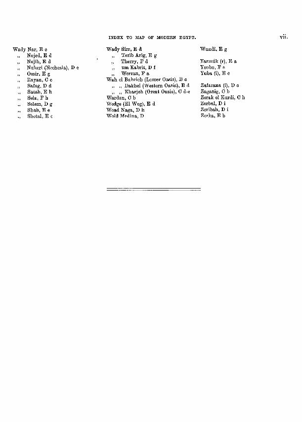
INDEX TO MAP OF MODERN EGYPT.
Wady Nar, E e Nejed, B d Nejib, B d Nukeri (Nechesia), D e Ossir, B g Ray an, C c Safag, D d Satab, B h Sela, F h Selem, D g Shab, B e Shetal, E e
Wady Sirr, B d ,, Terib Arig, B g ,, Therry, F d ,, um Kabrit, D f ,, Werran, F a
Wah el Bahrieh (Lesser Oasis), B c ,, ,, Dakhel (Western Oasis), B d ,, ,, Kharjeh (Great Oasis), C d-e
Wardan, C b Wedge (Bl Weg), B d Woad Naga, D h Wold Medina, D
Wundi, E g
Yarmiik (r), E a Yenbo, F e Yuba (i), E c
Zafarana (i), P c Zagazig, G b Zerak el Kurdi, C h Zerbul, D i Zeribah, D i Zerka, B b
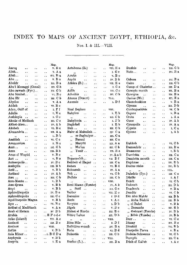
INDEX TO MAPS OF ANCIENT EGYPT, ETHIOPIA, &c. Nos. I. & III.—VIII.
Aareq AbtH Abtii Abu Abukir Abu'l Menaggi (Canal) Abu-rawash (Py r . ) . . Abu S imbe l . . Abu Sir Abydos Addeh Aden, Gulf of Adulis Aethiopia . . Ahn^s el Medineh Akhe t -Aten . . Aksheh Alexandria
>> Am^deh Ammonium Amt Amu Anas el Wogiid Ant Antaeopol i s . . Anthyl la Ant i Antinoe Anu Anu-Mentu Anu-Qema Anyt Aphroditopolis Aphroditopolis Apollinopolis Magna Apu . . Arabat el Madfuneh Arab el H e t a m Arabia Arko (Island) Arsinoe Arsinoe Asfun Asia Minor . . Asphynis . . Assyria
Map. V. B c V. A a
. III. B a V. B c
III. B a . III. G b . III. C b
VI. B c . III. C b
V. A a VI. B c
I. F f I. B e I. G e
III. G c IV. A b VI. B c III. A a
I. B b VI. C c
I. B c . III. C b , III. B b
V. B c V. B a
IV. B c . III. B b . V. B b
IV. A b . III. C b
V. B b . V. B b
V. B b IV. B c
. III. C c . V. B b
IV. B c V. A a
. 17 B b
. B F c-d-e
. VII. A c III. B c
. VIII.
V. B b • . 1 . B G D a
V. B b I. B a
Astaboras (R.)
} ) • * * '
Aswan Asyut Atbara (R.) . .
,, Atfih Athribis Atuma (Desert) Axumis
Baal Zephon Babylon
,, Babylonia . . Baghdad Bah B a h r el Mehalleh . .
,, es Sagha iye r . . ,, Fa r au i ,, Maryiit ,, Mu'izz „ Yusif . .
n n • • Begarawieh . . Behbeit el Haga r . . Behen Behneseh . . Bek Belb^s
,, Beni Hasan (Tombs)
„ SuM . . Berber Berenice Beris Berytus Bigeh Birket el Kurlin Bi t te r Lakes
,, ,, Blue Nile . . Bolbitine m o u t h . . Boon Bubast is
>) Bur lus ( L . ) . .
Map. . . VII. E e
I. G e V. B c
. . IV. B b . . VII. B e
I. C e III. C c
. . III. C b
. . VIII.
I. D f
. . VIII.
I. E b . . III. G b
I. F b I. E b
. . III. C b III G a III. C a III. C a III. A a
. . III. G b III. B c IV. A a-b
. . VII D f III. G a
. . VI. B d IV. A a
. . VI. C b
. . III. C b
. . VIII.
IV. A b III. C c
. . VII. B e I D d V. A c I. D b V. B c
III. B c . . m . D b . . VIII.
I. D f III. B a
. . VI. B d . . III. C b . . VIII.
III. B a
Busiris Buto
Gabasa Cairo Camp of Ghabrias . . Canopic mouth Canopus Gasius (Mt.) Ghenoboskion Clysma Gontrapselchis Coptos Greta CusaB Cynopolis . . Cyprus Cyrene
Dakkeh D a m a n h u r . . Damascus . . Damiet ta Damiet ta mouth . . Daphnae Darius stelse
)> ?j • •
Dahshur (Pyr.) Darfiir Debot Defeneh Dendereh . . Dendur D^r Abu Mak^r
,, Anba Bishoi . . „ el Bahr i ,, Ba ramus ,, Gebrawi (Tombs) „ Rifeh (Tombs) . .
Derr . . Dimay Dinshal Diospolis Parva Dodeca-Schoenus . . Dumyat Dush el Kal 'eh
Map. . . m . C b
III. B a
III. B a . . III. C b
III. D a III. B a III. B a III. E a
V. B a . . III. D b . . VI. C b
V. B a I. A a
IV. A b IV. A a
I. G a I. A b
. . VI. G b . . III. B a
I. D b III. G a III. G a
. . III. D b . . III. D b . . VIII.
III. C c I. A f
. . VI. G b
. . III. D b V. B a
. . VI. G b
. . III. B b
. . III. B b V. B b
. . III. B b
. . IV. B b
. . IV. B b VI. 0 c III. B c
. . III. B b V. B a
. . VI. C b III. C a
I. A c
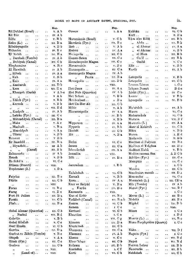
INDEX TO MAPS OF ANCIENT EGYPT, ETHIOPIA, ETC.
E d Dakhel (Road) . . E d D e r Edfu B d k u ( L . ) Bileithyapolis E k h m i m Bl A r i s h ,, Bersheh (Tombs) ,, Buhiyeh (Canal)
E lephant ine E l Hawateh „ Hibeh „ Kab „ Kais ,, Kanta reh ,, Kess „ Khargeh (Oasis)
,, ,, . . . . „ Kuleh (Pyr.) . . ,, Kurneh . .
) j » )
,, Kusiyeh . . ,, L a h u n (Pyr.) „ Mahmudyeh (Canal) . ,, Maks ,, Mashaik . . ,, Menshiyeh ,, Uksur
E r m e n t E r Raschid ,, R i y a s h ^ t . . ,, ,, (Canal)
E s h m u n e n . . Esneh E s Sebu'a E t h a m (Desert) Euph ra t e s (R.)
Fa iyum Fakus
,, F a r a s Fareg For t St Jul ien
Fostat Fiieh
Gebel Ahmar (Quarries) . ,, Barkal
Gebelen Gebel Silsileh Gerf Hus^n Gerrha Geziret ez Z^hin (Tombs) Girgeh Gizeh (Pyr.) Goshen
»» • • • • • ,, (Land o f ) . .
Map. V. A b
IV. A b . V. B b
III. B a V. B b
IV. B c III. E a IV. A b
. III. C b v. B c
IV A b IV. A a
. V. B b lY. A a
. i n . D b
. III. E a V A b-c V A b V. B b
. V. B b . VII. B d
IV. A b HI. G c III. B a
V. A c V. B a V. A a V. B b V B b
. III. B a III A b
. III. B b IV A b V. B b VI. G c
. vni . I. D a
III. B c . III. G b . VIII
VI. B c VI. B c
. III. B a . III. G b . III. B a
. III. G b . VII. B d
V. B b V. G c
. VI. G b . III. D a
V. B c V. A a
III. G c . III. C b . VIII.
. VIII .
Greece
H a m m a m a t (Road) H a w t e h (Pyr.) Heb Hebnu Heliopolis . . Henen-Seten Heracleopolis Magna Hermonth i s Hermopolis . . Hermopolis Magna
,, Parva . . Heroopolis . .
,, Het-Benu . . He t Nub (Quarries) He t Sefent . . He t S e s h e s t . . Het-Ta-Her-Ab Hibis Hieraconpolis
)) ,,
Hipponon . . Hypsele Horbet H u
Ibr im Iscum Iskenderieh Ismai l ia Itfu
Jerusa lem . .
Kalabsheh . . Karnak K a s a . . Kasr es Sa iyM
„ Kuriin Kassassin . . Kau el Kebir Kedabeh (Canal) . . Kemsa Kenem Kertassi Kha r tum
,, Khasuu Kha ta 'neh . . Khemenu . . Khemnu Khenu Khe r -Ahau Kolzum Kordofan Korti
Map. I. A a
V. C b III. B c
. . V. A b IV. A a
. . III. C b III. C c III. C c V. B e
III C a IV. A b III. B a
. . III. D b
. . VIII .
IV. A a IV A b V. B b V B a
. . III. C b V. A b
IV A a . . IV. B b
V. B b IV. A a
. . IV. B b . . Ill C b
V. B a
VI. G c III. C a III. A a
. . VIII .
IV. B c
I. D b
. . VI. C b V. B b IV A a
. . V. B a . . III. B c . , VIII .
IV. B c III. B a-b
. . VI. G b I G c
. . VI. C b I. G e
. . VII. G g
. . III. B a
. . III. G b III. G a IV. A b
. . V. G c . . III. G b . . III. D b
I. C f . . VI. C b
Kubban Kuft XAm Abu BillA
„ Afrin . . ,, el Ahmar ,, el Ahmar ,, el H i sn ,, Ga'if . . ,, Ombo
Ktis Kus^r
Latopolis Letopolis Leucos Limen Libyan Desert L ish t (Py r . ) . . Luxor Lycopolis
Ma'abdeh . . Maam Mahar rakeh Maraua Mareotis (L ) Masr el Kahi reh . . Matu Mecca Medamut Medinet el F a i y u m Meainet el Taiguna Medinet H a b u Mediterranean Sea Medum (Pyr.) Memphis
,, Mendes Mendesian mouth . . Men-nefer . . Menzaleh (L.) Mer (Tombs) Meroe (Pyr.)
,, Merur (L.) Metelis Migdol
5 1
Mines
,, Moeris (L.) Mons Porphyri tes (Qua
N a k a . . Napata (Pyr.)
,, . . . . Napet Nat ron Lakes Naucra t i s . . Nebesheh .
Map. . . VI. C b
V. B a . . III. B b . . III. B b
IV. A a . . V. B b . . III. B b . . Ill B b
V. G c . . V. B b
IV. A b
V. B b . . III. C b
I. G c B d-e
III G c . . V B b . . IV. B b
IV. A b VI. C c
. . VI. G b
. . VII. D f III. A a
. . III. C b . . V. B b
I . E d V. B b
III B c III. B c
. . V. B b . . A B G b
III. C c III. G c
I. G b . . III. G b
III. D a III. C c
. . III. CD a IV A b
. . VII. D f I. C c
III B c III. B a
. . III. D b
. . VIII.
I. C e I. D d
III. B c rry) i. G c
. . VII. D f I. G e
. . VII. B d
. . VII. B d
. . m . B b . . III. B b . . III. G b
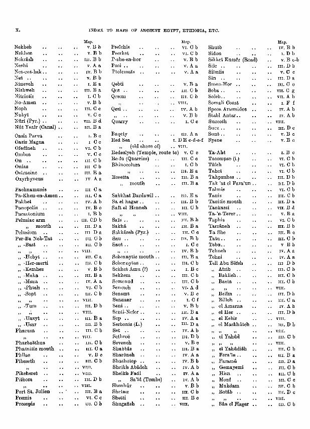
X . INDEX TO MAPS OF ANCIENT EGYPT, ETHIOPIA, ETC.
Nekheb Nekhen Nekr^sh Neshi Net-ent -bak. Net . . Nineveh Nishweh Nitriotis No-Amen Noph Nubyt Nuri (Pyr.) . Nut Yezir (Canal) .
Oasis Pa rva Oasis Magna Ofedineh Ombos On . . Onias Ostracine . Oxyrhyncus
P a c h n a m u n i s Pa -Khen-en-Amen . Pakhe t Panopolis . . Parae ton ium Pelusiac a r m
„ m o u t h Pelus ium Per-Ba Neb-Tat .
,, -Bast
J J »» • • •
,, -Hebyt . . „ -Her-mert i ,, -Kemhes ,, -Maka . ,, -Maza . ,, - P h t a h . „ -Sopt .
,, ,, „ -Tum .
?> ») •
„ -Uazyt . ,, -Usar
Phacusa
)> P h a r b a e t h u s Pha tn i t i c m o u t h . Phi lae Pibeseth
,, .. . Pikeheret . . P i thom
,, • • . Por t St. Ju l i en Premis Prosopis .
Map. V. B b V. B b
. III. B b V. A a
. IV. B b V. B b I. E a
III. B a I. G b V. B b
III. G c V. G c
. VII. B d III. B a
I. B c I G c
. VI. G b V. C o
. III. C b . Ill G b . III. E a
IV. A a
III. G a III. G a IV. A b IV. B c I. B b
. III. CD b III. D a III D a III. C b
. III. C b
. VIII. III. C a
. III. C b V. B b
III. B a IV. A a
. VI. C b
. III. G b
. VIII.
. i n . D b
. VIII. III. B a
. III. B b
. III. G b
. VIII.
. III. C b III. G a
V. B c . III. G b . VIII. . VIII. . III. D b . VIII.
III. B a VI. C c
. III. G b
Pselchis Pserket P-she-en-hor Psoi . . Ptolemais . .
Qebti Qes Qesem
, , . . o .
Qesi . .
,, . . . . . . Quarry
Raqety Red Sea
,, (old shore of) Redeslyeh (Temple, route Re-fu (Quarries) Rhinocolura
,, Rosetta
,, mou th
Sabkhat Bardawil . . Sa el hagar . . Saft el Henneh
,, ,, Sais . . Sakh^ Sakk§,reh (Pyr.) Sau Saut . .
,, .. Sebennytic mou th . . Sebennytus . . Sekhet Amu (?) . . Sekhem Semenud Semneh Senemt Sennaar Seni . . Senti-Nefer . . Sep Serbonis (L.) Set Sethroe Seveneh Shabbas Sharoneh . . Shashotep . . Sheikh AbMeh . . Sheikh Fad l
Sa'id (Tombs) Shenhur Shetnu Shet t i Shugafieh . .
Map. . VI. C b
. . VI. G b . V. B b
V. A a V. A a
V. B a . III. C b . III. G b . VIII.
IV. A b V. B b
I. G c
III. A a I. D E c-d-e-f
. . VIII. to) V. C c
III. C c I. G b
. . III. E a . . III. B a
III. B a
. III. B a . . III. B b . . III. C b . . VIII. . . III. B b
III. B a III. C c
. . III. B b I. G c
. . IV. B b III. B a
. . III. C b I. B e
. . III. G b
. . III. G b
. . VI. A d V. B c
I. G f . . V. B b . . III. B a
IV. A a . . n i . D a
IV. A b . . III. D b
V. B c III. B a IV. A a
. . IV. B b IV. A b IV. A a IV. A b V. B b
. . III. G b III. B c
. . VIII.
Shutb Sidon Sikket Kuss^r (Road) Sile Silsilis Sin Smen-Hor . . Soba . . Soleb Somali Coast Specs Artemidos . . Stabl A n t a r . . Succoth S u e z . . Sun t Syene
Ta-Aht Tacompso (i.) Tafeh Tahet Tahpanhes . . Tak 'at el F a r a ' u n . . Ta lmis Tanis Tani t ic mouth Tankass i Ta- 'n-Terer Taph i s Tar raneh Ta-She Ta tu Tebu Tehneh Tehni Tell Abu SMeh
, Atrib , Baklieh , Basta . .
, ,, . . . . , Belim , Billeh , el Amarna , el Her . . , el Kebir , el Maskhliteh . .
5 5? ) ) • • •
, e l Y a h u d
5 ) 5 ) 5 • • •
, e l Y a h u d i ^ h . . , Fera ' in . . , F a r a m a , Gemayemi , Hisn , Monf , Mukdam , Rotab . .
5 ) ) • • • • •
, Sdn el Hager . .
Map. . IV. B b
I. D b V. B c-b
. III. D b
. V. G c III. D a III. C c
. VII. C g . VII. A b
I. F f IV. A b IV. A b
. VIII. III. D c
V. B c V. B c
I. B c VI. G b
. VI. G b
. VI. C b
. III. D b
. III. D b
. VI. C b
. III. G b III. D a
. VII. B d V. B a
. VI. C b
. III. B b . III. B c . III. G b
V B b IV. A a IV. A a
. Ill D b
. III. G b
. III. C b
. III. G b
. VIII.
. III. D b
. III. G a IV. A b
. III. D b . VIII. . III. D b . VIII. . III. C b . VIII. . III. C b
III. B a . III. D a . III. C b . III. G b . III. C c . III. C b . III. D c . VIII. . III. C b
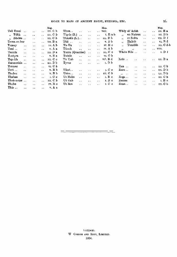
INDEX TO MAPS OF ANCIENT EGYPT, ETHIOPIA, ETC. XI.
Tell T m a i . . ,, T u k h . . ,, Zliel^n . .
Tema-en-her Temay Teni Tennis Tentyra Tep-Ah Terenuth is . . Termes Tert Thebes Thebae Theb-neter . . Thebu This
Map. . III. G b . III. G b . III. C b . III. B a
IV. A b V. A a
. III. D a V. B a
III. G c . III. B b . VI. G b
V. B b V. B b I. C c
. III. C b IV. B c V. A a
Thou Tigris (R.) Tims§,h(L.) Tud Tu-Ka T u n e h T u r r a (Quarries) . . Tutz is T u U a b Tyrus
U h a t U s i m . . U t M e h t U t U a b U t R e s
Map. . VIII.
I. B a-b . III. D b
V. B b IV. B c IV. A b III. G c
. VI. G b . vi i . B d
I. D b
I. C c . III. C b
I. B c I. B c I. C c
Wady el A r i s h ,, en Nat ron . . ,, es Sofra „ Half eh
„ Tumimt ,, ,,
Whi te Nile . .
Xois . .
Zan . . Zaru . .
,, .. Zeqa . . Zeszes Z o a n . .
Map. . . III. B a . . III. B b . . VII. D f . . VI. B d . . III. C d-b . . VIII.
I. D f
III. B a
. . III. C b
. . III. D b
. . III. D b
. . III. C b I. B c
. . III. G b
LONDON:
W GEIGGS AND SONS, L I M I T E D .
1894.
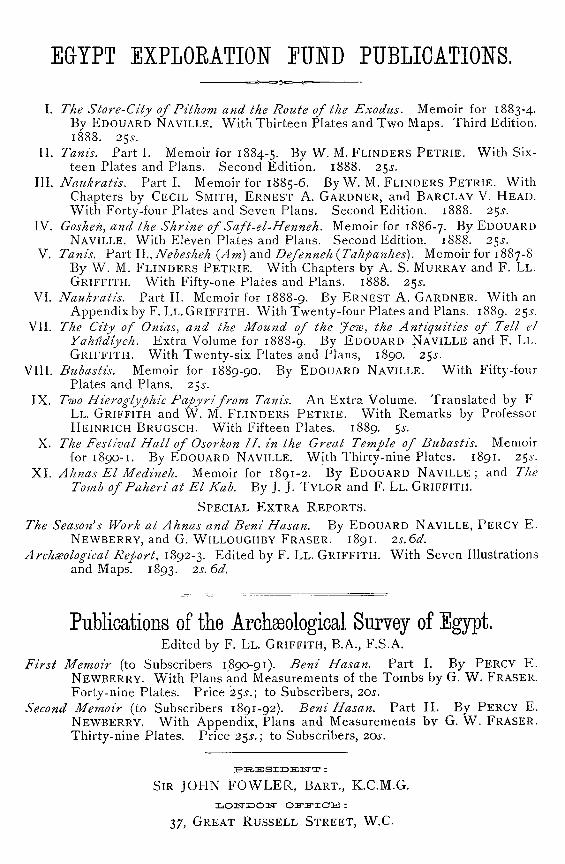
EGYPT EXPLOEATIOE" FUND PUBLICATIONS.
I. The Store-City of Pithom and the Route of the Exodus. Memoir for 1883-4. By EDOUARD NAVILLE. With Thirteen Plates and Two Maps. Third Edition. 1888. 255-.
II. Tanis. Part I. Memoir for 1884-5. By W. M. FLINDERS P E T R I E . V^ith Sixteen Plates and Plans. Second Edition. 1888. 2^s.
III. Naukratis. Part I. Memoir for 1885-6. By V/. M. FLINDERS PETRIE. With Chapters by CECIL SMITH, ERNEST A. GARDNER, and BARCLAY V. HEAD. With Forty-four Plates and Seven Plans. Second Edition. 1888. 2$s.
IV. Goshen, and the Shrine of Saft-el-Henneh. Memoir for 1886-7. By EDOUARD NAVILLE. With Eleven Plates and Plans. Second Edition. 1888. 2^s.
V. Tanis. Part ll., Nebesheh {Am) and Defejtneh {Tahpanhes). Memoir for 1887-8 By W. M. FLINDERS P E T R I E . With Chapters by A. S. MURRAY and F. LL . GRIFFITH. With Fifty-one Plates and Plans. 1888. 2^s.
VI. Naukratis. Part II. Memoir for 1888-9. By ERNEST A. GARDNER. With an Appendix by F. LL. G R I F F I T H . WithTwenty-four Plates and Plans. 1889. 2^s.
VII. The City of Onias, and the Mound of the Jew, the Antiquities of Tell el Yahudiyeh. Extra Volume for 1888-9. By EooUARD NAVILLE and F. LL.
G R I F F I T H . With Twenty-six Plates and Plans, 1890. 2$s. VIII. Bubastis. Memoir for 1889-90. By EDOUARD NAVILLE. With Fifty-four
Plates and Plans. 25 -. IX. Two Hieroglyphic Papyri from Tanis. An Extra Volume. Translated by F
LL. GRIFFITH and W. M. FLINDERS P E T R I E . With Remarks by Professor HEINRICH BRUGSCH. With Fifteen Plates. 1889. 5 -.
X. The Festival Hall of Osorkon / / . in the Great Temple of Bubastis. Memoir for 1890-1. By EDOUARD NAVILLE. With Thirty-nine Plates. 1891. 25.5-.
XI. Ahnas El Medineh. Memoir for 1891-2. By EDOUARD NAVILLE ; and The Tomb of Paheri at El Kab. By J. J. TYLOR and F. LL. GRIFFITH.
SPECIAL E X T R A R E P O R T S .
The Season's Work at Ahnas and Beni Hasan. By EDOUARD NAVILLE, PERCY E .
NEWBERRY, and G. WILLOUGHBY ERASER. 1891. 2s. 6d.
Archdsological Report, 1892-3. Edited by F. LL. GRIFFITH. With Seven Illustrations and Maps. 1893. 2s. 6d.
Publications of the Archaeological Survey of Egypt. Edited by F. LL. GRIFFITH, B.A., F.S.A.
First Memoir (to Subscribers 1890-91). Beni Hasan. Part I. By PERCY E. NEWBERRY. With Plans and Measurements of the Tombs by G. W. ERASER. Forty-nine Plates. Price 255-.; to Subscribers, 20s.
Second Memoir (to Subscribers 1891-92). Beni Hasan. Part II . By PERCY E. NEWBERRY. With Appendix, Plans and Measurements bv G. W. ERASER. Thirty-nine Plates. Price 2^s.; to Subscribers, 20 -.
SIR JOHN FOWLER, BART., K . C . M . G .
37, GREAT RUSSELL S T R E E T , W.C.