Embed Size (px)
Citation preview

~ 1
f
1
J
1
1
1
cor·-~TEt-~TS
: ~···!TR.1J:.:UC:T I or··.J
Clirr:ate
3 WORKING METHODS .-, ., ,,: •• ..!.
'=' --=· ·-' . .:..... :3. 3.
3.4 ~ ~
-::.·. ·-'
4.2
4.4
In troclt...:ct ion Air photo interpretation Field ·s.~ri1Pling
3.3.1 13eneral 3.3.2 Samples, environment and soil 3.3.3 Vegetation relevees Field sample processing Final map preparation
The seven main landscapes Agriculture and other landuse in the survey 2rea 4.2.1 Agriculture~ general 4.2.2 Annual crops 4.2.3 Perennial crops 4.2.4 Tree crops 4. 2. 5 !....i 1,,e·stoc:k (.~.2.G Fore-:.trv 4;2.7 Bee keeping
Sociological groups and plant communities
Description of the Mapping cnits
·• Ocotea usambarensis - Strombosia scheff!eri Ls 2 Croton megalocarpus - Coffea ar2bica Ls 3 Dombey~ rotundifolia - Mangifera indica Ls
LIBRARY 1
10 10 10 11 11 11 11 14
16 16 1 7
17 '~ .l. ...
19 ·1 Ç.t ..... -··
20
47
4? 4:3 49
4 Combretum zeyheri - Combretum binderianum Ls 50 5 Hyparrhenia sp. - Hetereropogon contortus Ls 6 Acacia senegal_ - Commiphora africana Ls 7 LISP 10 - Ochna ovata Ls
L.. I TEF~.ATL!RE
52
60
61
62
APF'Et'-~[) I C:ES; I Vegetation and Landuse + LE"; end
rn.3p 1:100,000
II Vegetation table !!! List of plant names r '-) Field sample form
1

Scanned from original by ISRIC - World Soil Information, as ICSU World Data Centre for Soils. The purpose is to make a safe depository for endangered documents and to make the accrued information available for consultatîon, following Fair Use Guidelines. Every effort is taken to respect Copyright of the materials within the archives where the identification of the Copyright helder is clear and, where feasible, to contact the originators. For questions please contact [email protected] indicating the item reference number concerned.
[
·- l .'.);
"' irn~ te in ~-Jes tern par t -<
'" .. ~i i2 .:i.rea
3e: '"'1 irnate i n e2stern par t of the area ~·
4 Rainfall uariation in eatern part of the area
5 Total rainfall compared with dailv rainfall in eastern part of the area
5 A-\) t.}e-:;etation strLlc:ture diagr.5;ns
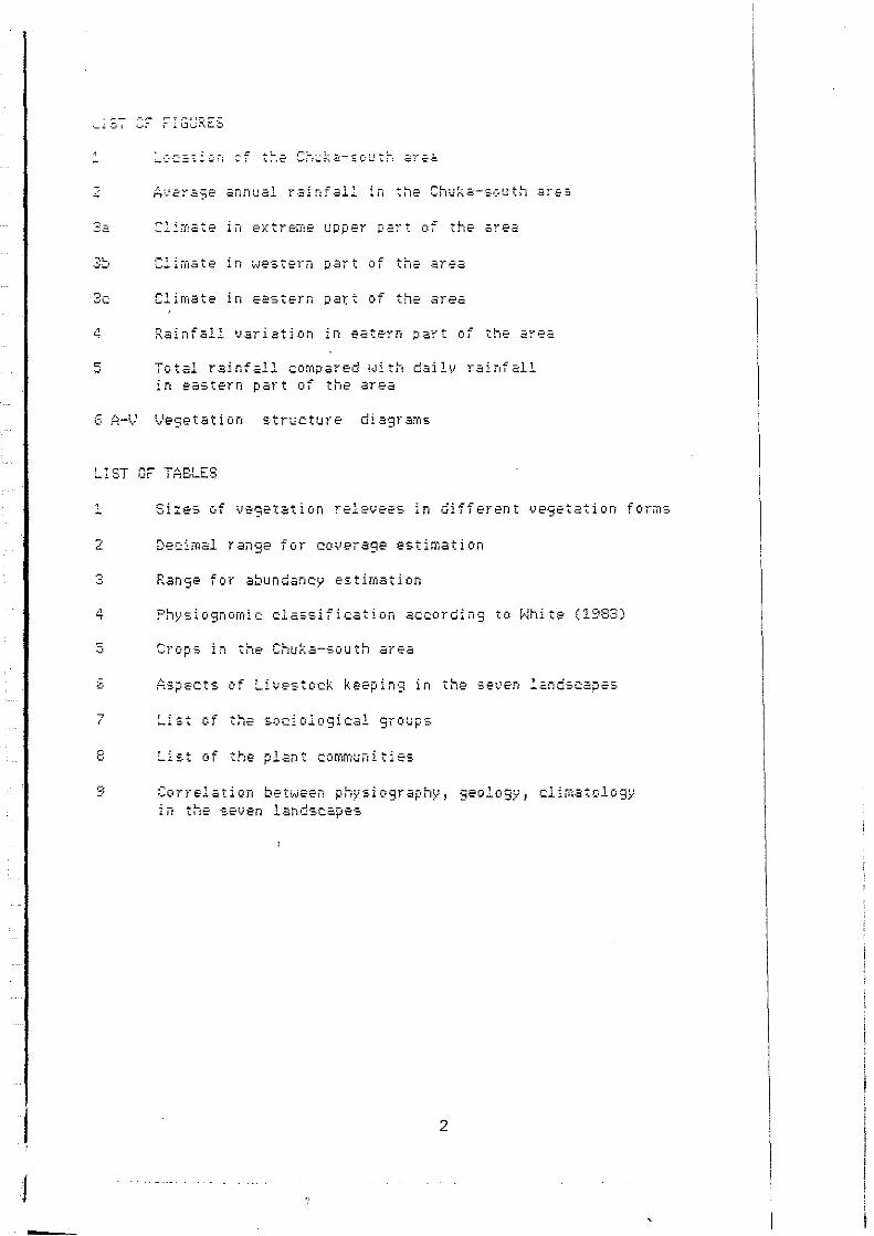
LIST OF TA8LES
' • Sizes of vegetation relevees in different uegetation forms
2 Decima! range for coverage estimation
3 Range for abundancy estimation
4 Physiognomic classification according to White (1983)
5 Crops in the Chuka-south area
G Aspects of Livestock keeping in the seven !andscap2s
7 List the soc:iolosical
8 List of the plant communities
9 Correlation between physiography, geology, climatology in tt-ie set; en landscape·:.
2

1
f
1 1
l
1 INTRODUCTI Cl-1
The Chuka-south area, the study area, is situated on the eastern slopes of Mt. Kenya (Eastern Province, Kenya), see figure 1. lt was selected because of the enviror1mental variation, dimatical it varies from humid to semi-arid 1 geological from volcanic to metamorphic and physiographical from Mountain Footslopes to Uplands.
In 1985 and 1986 the TPIP (Training Project in Pedology) of the Agriculture Universi t\' Wageningen in the Netherlands has conducted soil surveys and related surveys in the Chuka-south area, as a following up of previous projects in Kisii and Kilifi. In close cooperation with the Kenya Soil Survey a 1:100,000 soil map has been prepared. The work t-.•ill be finished wi th an overall land evaluation of the area.
A part of this work is the preparation of a Vegetation/Landuse map, scale 1:100,000, necessary for an sound landevaluation. The presented map and the descriptions of landscape, vegetation and landuse are based on interpretations of 1968 air photographs (1:50 1 000), corrected to the present situation. Four months of field work was spend to describe the interpretation units.
FIGURE 1: LOCAT!ON CHUKA-SOUTH AREA
SUDAN ETH!OP!A
KENYA UGANDA
1
.. ,------·- -------~~~~~~7-,~·------[-~,~~ CHUKA-SOUTH ARE;. \
300 r-M
SCAl.E
,,' ', T.:.NA
Nairobi
T.<'è'IZANIA
3
\ i \ i

,,_
2 GEOLOGY, PHYSIOGRAPHY AND CLIMATOLOGY
As an introduction to the next chapters a generalised image is given of the environmental factors of the area. For more details see the report Geology of the Chuka-south area by Veldkamp and Visser and the several soil reports by uarious authors.
2.1 Geology A major division can be made between the relatively young Kenya volcanics which dominate the western part of the Chuka-south area and the precambr i an Basement Sys tem whi ch domi nat es the eas tem part of the area, Going from the past to the present: In precambrian times (more than 500 million years ago) the metamorphic Mozambique belt was f.ormed. I t covers much of Eastern and Southern Africa. The Basement Svstem which dominates large areas of Kenya is part of it. It is formed by layers of sediments, later completely metamorphised. The majori ty of i t consists of uarious types of gneisses, south of Ishiara predominantly biotite and hornblende gneisses, in other parts Hornblende gnei sses predomi nate. In these gnei sses r1arrow amphi bol i te bel ts occur. The plagi oclase ( a f eldspar) in the weathering gneisses and amphiboli tes is the source of Ca in the secondary lime which accumulates especially near riuers. Locally in the cental and northern parts of the area, the 9neisses have been further metamorphised into granulites.
Two major types of intrusives are found in the Basement System rocks: a range of granitic intrusiues is found in the eastern part of the area. Mumoni is part of onè range , Kijege and '.1erere are of an other r.>nge (all SW-NE). Outside the area they continue. The nucleus of these intrusives is pure granite, but :~e peels are granitoid gneisses. They are formed several ':lometers. beloi,,,1 surface and finally appeared after c.Jeathering of sof ter layers. The surrounding gneisses are softer and more öen·;i tive for erosion. In this wa\' the grani te bodies remained and rose above the surroundings as "Inselbergs 11
• In the northern oart af the area seueral other intrusiues dominate the landscape. 7~eu differ largely of the Mumoni and Kijege range in consisting : ; ;oredominatly (ul tramafic) hornblende gabbros and granuli tes. ·'~ overal strike in the area is south west- north east. This
:an t•e easily s.een in th.e direction of the Tana riuer, especially '.~e •authern part of it, where it flows str2ight trough a belt of 'el2ti•;;; soft hornblende gneisses and avoids the surrounding ~ran1toid gneisses. :C :he <-.•es tem part of the area some small grani tic Hills can be ~cur,d, rernnants of Inselbergs like the eastern ones which are -••9ely couered by uolcanic deposits.
4

; l
Ouite recently major changes took place, preceded by the formation of the Rift Valley. Mt. Kenya , a volcano , was formed and 3.5-2 million years ago flows of Phonolite and especially Lahars (mud streams, a mixture of 1,;ater, pyroclastics phonoli te and other ei·oded rocks) covered the western part of the area. Often these flows were very fluid and could reach distances of up to 50 km. They covered the area, exept the peaks of the granitic Intrusives. At the end of the flows no real ~ltitude difference existed between the volcanic flows and the Basement System area. Due toa difference in erosivity, nowadays differences of more than 100 m can be found.
R.oughly at the same time as the activi ty of Mt. Kenya , craters of the Nyambeni range (north of the Chuka area) were active and basalt flows from there covered much land north of our area. A few basalt flows streamed through rivers like the Mutonga till the Tana river (the lowest part of the area). Nowadays remnants of these flows can be seen as plateaus. The surrounding Basement Svstem rocks eroded faster than the basalt (inversion),
7his volcanic activity changed the drainage pattern of the area con si derably. One of the most consp i ei ous aspects of the eas tern cart of the area are there fore the numerous river terraces (not "ll of them very easily detectable). The Tana terraces are rich in P\iroclastics, the terraces of the Thuchi and Ruguti rivers contain mixtures of as t>Jell Basement material as Phonoli tes.
Colluvium from the ~îlls rejuvenates ~ffects, especially
volcanic area and the numerous Mountains and locally the landscape. This has had large after the clearing of forests.

,------------------_ 1
i ' .l
2.2 Physio9raphy In this description all landform classification names are used as aefined by the Ken~ia Soil Survey in their internal communication nr 13, 1978.
Starting at the hi9hest point of the area (2100 m), the slopes of Mt. Kenya form a landscape which is called Mountain Footridges This landscape consists of more or less parallel ridges with a ;lope down towards the east. These ridges are seperated by •.!alleys, differin9 in depth and width. Four of them were bi9 enough to map, they have their origin in the alpine zone on Mt. ~'.enya.
In the southern part of the area these Mountain Footridges change ;t ± 1300 m altitude into a Plateau with a slope of a fe1,i percent to the east and very undulatin9 topo9raphy. The same major •;alleys di ssect thi s Plateau , they are however much smaller than cp•,;ards. Several other valleys are formed in this landscape and -:au-;e a much more dissected landscape. In the east the Plateau is ~ounded by a scarp of up to 100 m high. :;eorth of the Plateau the Mountain Footridges change : "olcanic) Uplands _ (1200 m) wi th an undulating to to:-"ography and wi th an average slope of more than 10~: ~o the east.
in to rolling
di rected
i~ere the boundary to the (Basement System) Uplands is qui te 3r.adual and is on several places interrupted by the a smooth transition to the Hill~ and Mountains of the (basic) lntrusives. : ::oom alti tude). They are of approximatel,, the same alti tude as "" "estern part of the (volcanic) Uplands, but rise more than
:c•o m above the (Basement) Uplands. Their topo9rapr1y is in :-?iieral hill~' or rnountaineous (slopes > 16%).
--e Uplands in the Basement S;•stem are 9ently u_ndulating to ·c·llir19 and are dissected by several relative small valleys
:·:·cnpared to upl-.1ards). Many small seasonal streams dissect the :~~d , relative deep (several meters). Many riverterrac:es with a ·:., to gently undulating topography are found near the rivers. :-iese r1tJers strearried in tr1e volcanic: landsc:apes more or less
:•rallel to each other. Here in the Uplands they flow to one :•otral point north of the Kianyongo Hills where they join and ;~ow in the Muton9a and finally in the Tana river. ·.:~=.~re qui te common, n-1ost of them rise a fe1".J hundred n1eters ~:ove the surroundings and have quite extended footslopes.
-co Tana ualley is surrounded by the Mountain range of Kijege and "_:,1or1i ~·hich rise up to 1500 m and some other Hills. Several • i lorneters wide, wi th an undulating topograph-y--the valley :cr-;i1nates the extrerne eastern part of the area. Riverterraces are :u1 te ièomrnon along the Tana, some of them are flat (north), in "'•• ö-üuth they have a slope of seueral percents (but much less '.c.an the other Uplands) and are dissected. Seueral wadis (very ,.;!oe r1 1Jers whie:h floi,..1 only a few davs a year) dissect the '_·:l:irids east of the Tana. The river bed. is sa~dy and flat.
6

2. 3 Cl imate :n general the climate in the Chuka-south area ranges from rr,ountaneous humid to semi-arid. Figure 2 shows the average annual rainfall in the area. The correlation between the amount of rainfall and altitude is very high. As a rule of the thumb one can say that the amount of rainfall in millimeters is the same as the altitude in meters. The dominating eastern wind is responsible for this and causes for a rising aroount of rainfall •o the west and spots of wet areas on the Mountains in the east.
Figure 3 shows the annual rainfall distribution for three cr,aracteristic places, Embu forestry station (1905 m) for the highest part of the area, Chuka (1470 m) for most of the western >•art of the area. Tharaka (914 m) is characteristic for the >?astern area,
'.n general two rainy seasons are present , one long (march, april •nd may) and one short (october and november). The amount of ·ainfall in each does not differ. High, in the extreme western :·art of the area, also rain is possible in the period of june :111 september. In january and february no rain falls.
-~ese figures show only the mean annual rainfall. Especially in --,e s.emi -ar id eas tern part of the Chuka-sou th area con si der able . •riation in annual rainfall is found. Figure 4 shows the amount ·• ,-ainfall ·in several years in Marimanti (15 km north of ~· 1 ·1:c.\.;3rige in a e:omparable environrnE-nt). '•:nfall measurements show (figure 5) that a considerable part of ·ce ra1n falls in one day • In two or three showers more than 70%
~r«:> total amount of rain falls!. These showers fall very .::•lly (due to the topography) and it aften happens that one : ~~:icular area does not receive such a shower at all. In this -~-· :t is a dry year for that area.
•:<nb the amoun t of rai nf all is important, al so the ·,:··'.·"~t1or" which depends on the temperature and humidi ty. The
·: :-~r the alti tude the lower is the temperature and even more : - : : ·· '. '" t, the lower is the amoun t of sunshi ne ( due to clouds) .
. - - - - 2: A'v'ERAGE ANNUAL RAINFALL IN CHUKA-SOUTH AREA
' ' '
7
/< - ! ~)
-'--1--r-- 'f\-.. / I i \::.f..
gerUj
O /

FIGURE 3A: CLIMATE EXTREME UPPER PART OF THE AREA
.::::::::::::= ., '. -,-,. ~co Il
se- r
C] /
LHl livl-m
Nr.: 9037077 Ernbu For. St.
0 2! S 37 29"( 190$m
ny vp 10 1976
av. 1992 mm 60 % 1739 mm
,__av. ternp 17 °c ~ 1
= " . ~ .
i " r ,-J L. - ----~ -
~--:-i r 1 1 1 1
u~
O.L..-Ll...1--U..-Ll...l--L-L-Ll-Llc..LLlJ.Jc..LLl-Ll-LLLJ_ __ J__j_o
Mc _ _;_A_;__'~·'--""'"'_J ___ A _ ___;s:__~,o:;__~N~,ilo---'-J-_.:,F
FIGURE 38: CL!MATE IN WESTERN PART OF THE AREA
r----~. ::::::---:-:~-------~:::::::::;::-------.mm '--. -~ UM 1 m/l+m/s
Nr.: 9037034 Chuka
0·20 S 37 38E
30y uo lo ;s76
14i0m
r-----, 1 •
!
l 1 -+- ----
r,', A \l J A s '-----590-----'
F D '-------520-----' 0 N
F"l GURE 3C: CLIMATE IN EASTERN PART OF THE AREA
Tharaka Chief"s Camp {Kilui D.)
o· 1a·s :ia·o2·E 914 m
,4 y VP I<> 197'5
-----
M A . '--295----'
. --.:- Average ra1ntall oer decade
A s 0 "-' D '---185~
ra1nfall surpassed in 6 ou1 of 10 years
--- Approx. pot. evaootranso1ra11on at a permanen1 erop
-- Aoorox. pot evapotransprratron of late mat. ma1z.e
F
>00
50
mm
·•00
'--- 1oao--· Ra1ntaU per indicated grow1ng period, surpassed m 6 out of 10 years
8

FI GURE 4: RAINFALL VARIATI ON IN EASTERN PART OF THE AREA
!i.o.J..~..!"~!l ,~1 .~ .. ,,..,
1,
"~
!910 l97S 1980 ""
FIGURE 5: TOTAL RAINFALL COMPARED eHTH DAILY RAINFALL IN EASTERN PART OF THE AREA
.. ~ mOv
-1 :1 d;J CL 1 g
::i ~ ' :1: 0 1
:j _, Q, - [1 .• J
_j = :j
""= Q . Rem .• J
~~ _J -j
=[~ .,.,j
1
"J
::J J1 ··j n .• J -J
~ -1
'"~ .• ,
1 , ' . '
"'l ". JH dJ Jb
'--...,,-, ~. \;;~~~, ...,--,--, • ~. • ,"?---, -
0 · rainf&.11 (mm/mon1h)
9

3 WORKING METHODS
3.1 Introduction In order to be able to map an area of this extend an efficient and convenient method is needed. We have chosen for the landscape 9uided (=physiographic) method as 'developed by the ITC (International Institute for Aerial Survey and Earth Sciences) (Zonneveld 1982). îhis method is based on the use of air photographs to landuni ts on physiographic basis and on a lower vegetation and landuse differences.
delineate level on
During the fieldwork these units are sampled in a so called s tr at i f i ed random way: sampling act i v i ty is di v i ded between all airphoto interpretated (API) units, with in principle an equal attention to each unit.
3.2 Air Photo Interpretation Air photographs on a scale of 1:50 1 000 were the basis for the interpretation map. A major problem was that these photos showed the :.i tuation in 1968. Major changes could be expected in a time span of nearly 20 years. More recent (1982) air photographs of a scale of 1:12,500 were available for only a very limited part of the area. We have used them occasionally to observe major changes '-•hich were observed in the field. A satelli te (landsat MSS) image, scale 1:250 1 00, was used for a rough impression of the extent of various landscapes.
Ïhe 1968 1: 50, 000 air pho togr aphs were in terpretated wi th as first di v i si on major landscape di ff erences ( based on gener al landforrr1 differenc:es in the terminolog~' of the Kenya Soil Survey). On a lower level differences in individual landforms and uegetation/landuse were used to differentiate API units. Same !andscapes could not be diuided in any detail (the Mountain Ra1n forest). There more attention had to be given during the '.1eld<A1ork to find correlations between air photograph characteristics and uegetation differences. Howeuer for the ~.ajori ty of the area no such problems were encountered. In this Wö\1 an API map of scale 1:100 1 000 t~as prepared and used to :•repare the fieldwork, (sample places and route~.).
10

3.3 Field sampling
3.3.1 General By car and motorcycle parts of the area were vi si ted and subsequent API units 1,1ere sampled. Especially those units i..1ere visi ted which were adjacent to each other (the clustered aspect of the method). This was not only efficient but also showed the tr an sit ion between the var i ous units very well and gave an impression of the validity of the boundaries. The samples were taken guided by the appearance of the vegetation, in genera! not too close near a road or an other disturbed area (unless that was the object). In general only a sample was taken when the area could be detected on the air pho togr aphs. Dur i ng the fieldwork the di ff erence of the vegetat ion and landuse bett.ieen 1968 and present (1985) became a problem. Especially in the eastern part of the area units could consist of high bushland which i..1ere previously bare farmland (and vice versa). In these cas;;s sampling was not that much related to the specific place as i t was el se wr1ere. Sometimes this was avoided and a non changed örea "''as sampled. However in genera! this did not cause any Droblem and the specific sample place was precisely noted on the <>ir photograph. In this way all units were sampled (at least 2 öamples in each unit), some very inaccesible parts (the tops of ine mountains in the eastern part of the area) could only be observed by glasses.
3.3.2 Samples: environment and soil H total of 180 samples have been made, distributed over 30 API units. Each of them c:onsists of a relevee of the vegetation, an öu·3erin9 and general remarks of the landscape and landuse. See oDC•endix nr IV for a sample form which has been used to registrate all data. As said before each sample was noted on the "r pho tographs and on the API map.
~.3.3 Vegetation relevees .'egetation relevees i..1ere of different sizes, dependant on the ·1nd of uegetation structure. Table 1 shows the sizes which have :een used for relevees in different physiognomic uegetation :yoes. Some releuees were made with a different size for tree•nd grass layer, especially in landscape 5 where a sparse and '."°P:?terogenous tree layer covers less than 10%. In order to
•e91strate that layer a relevee of more than_lOOO m2 ha~ to be :.-.aae, the grass la;•er can be descn bed in a s1 ze of 20 m .
;A8LE 1: SIZES OF VEGETATION RELEVEES IN DIFFERENT VEGETATION FORMS
VEGETATION STRUCTURE
Hoodland & Bushland Shrubland & Thicket Arable land Grassland Hooded Grassland
11
RELE\.1EE AREA M2
400 150-200 400 25 1000

Vegetation structure We usually started with describing the uegetation structure, see fiqures 8 A-V. In a scale of 0-3cm, 3-12.5cm, 12.5-25cm,25-50cm, 50~m-1m, 1-2m 1 2-4m, 4-Sm, 8-16m, 16-32m and 32-64m the external and internal coverage was noted. With both data the real coverage can be calculated:
real couerage (%) = external coueraqe (%) x internal coverase(%) 100
~:ternal coverage: is the coverage of the vertical projection of the plant
Internal coverage: is the part of that projection which covers the ground
Real coverage: is the total part covered by the plant.
In table 2 the decimal coverage estimation scale is given.
TAB LE 2: DECIMAL RANGE FOR COVER ESTIMATI ON
NOTATION RANGE OF COVERAGE cover age
external internal < 2%
00 0 2 - 5 % 01 1 5 - 1 C!'t'/ ..," 02 2 15 - 25% 03 3 25 - 35~;
04 4 35 - 45~4
05 5 45 - 55~~
06 6 55 - 6C!'t'/
"" 07 7 65 - 75% 08 8 75 - 85% 09 9 85 - 95% 10 10 95 -100%
~xternal couerage in first column, internal in the second
Floristic composition ln each relevee all plant species were noted and an estimation was made of the external- and internal coueraqe of the individual plantspecies with the decimal scale is shown-in table 2. Also notes h•ere made of the abundancy of the plants , see table 3.
12

TABLE 3: RANGE FOR ABUNDANCY ESTIMATION
NOTATION ABUNDANCY 1 1 per 1000 m2
2 1 per 100 ~2 3 1 per 10 !:9 4 1 per 1 m; 5 10 per 1 m 2 6 1 per 1 dm
2 7 10 per 1 dm
Naming plant species A major disadvantage of the floristic method is the difficulty "'i th naming the plantspecies. In a diverse area as the Chuka south area more than 2000 plantspecies can be expected (not all needed for a floristic classification). We have used several methods in order to over come this problem.
,;11 unknown species encountered in a relevee were collected in a quick herbarium and were given a nickname and a collection number. ;.je tried to reveal the local name from passers-by, who also taught us how to recognise the plants. This collecting took much 1ime especially in the eastern part of the area,where the plants were often dessicated and only vegetatiue. The local names could provide us the scientific names. In other .:ases the quick herbarium was determined by ourselves and by the East African Herbarium in Nairobi.

2.4 Field sample processing
.·~109nomic classification confusion exists in the numerous classifications, a term
·e sauanna is so often used in so many different ways that the ·-does not have much meaning anymore. We have chosen for the ·::le ph\isiognomic clasification as given by White 1983, see
·.:~e 4 fora description of the 10 units. This classification .sed in the legenda and the various descriptions only to give 'irst imoression. More detailed vegetation structure
:ss:fications as given by the Kenya Soil Survey are only given :or;,plete the image , for pratical use they are much too
:!:cated. In case of cultivated land not the physiognomic .:s1fication is used but the term Farmland and the degree of .. "3tîon.
··· · ·.: F'HYSIOGNOMIC CLASSIFICATION ACCORDING TO WHITE (1983)
">.! .o,.: i0SS
· "!'.tl lS/\L
''.0 -.,:
.' .,"~: :\ continuous ·.t:i.! ,-.: trees at least
·:1 :.1!!. thetr crowns · : ~~ .• "- i..in~.
.i · • ~:;.;ni!. :\n open · .1:":, .f ::-ces at least
• ··~ :.1:: u.1th a ca.nopy '"'. , ·f .!il pcr cent or ·~ :::~ f;cld layer .·,.1,;\ donunated
:.:.-: •• 1.-:..i. :\nopen • :->u~hes usuallv
·· -.,,, -~:: -~ ;~nd 7 m t3lÎ .. l::,,rv cover of .c:;: nr n1ore.
- ---•.r!. A ciosed ! '.-c:\be,.<; anà
. ..,..'.\ ~l\ll,i!Îy be· " .... :-. ' .:nJ ï m ta.11.
··c.:· .. :-:.i. :\nopen · .·,: \::tnd of
.. \ .. :' : ,) ::. :!}
5. Grassland. Land covered with grasses and other berbs, either 'Without woody plants or the latter not covering more than 10 per cent of the ground.
6. W ooded grassland. Land covered with grasses and ether herbs, wîth woody plants covering betwecn 10 and 40 per cent of the ground.
7. Desert. Arid landscapes with a sparse plant cover, except in depressions where water accumulates. The sandy, stony or rocky substrate contributes more to the appearance of the landscape than does the vegetation.
8. Afroaipine vegetation. Physiognomically mixed vegetation occurring on high mountains where night frosts are liable to occur throughout the year.
· -~:: :!assification
TR.ANsmONAL FORMATIONS
OF LOCAL EXTENT:
9. Scrub /oresz. Intermediatc between forest and busbland or thickct.
l 0. Transition woodland . Intermediate betwcen forest and wcxxlland.
11. Scrub woodland. Stunted wood.land less than 8 m tall or vegetation intermediate between woodland and bushland.
EDAPHIC FORMA TIONS:
12. Mangrove. Open or closcd stands of uces or busbes occurring on sbores between bigband low-water mark. Most mangrove species have pneumatophores or are viviparous.
13. Herbaceous fre.sh-waler swampand aqualic vegetation.
13. Halophytic vegelation (saline and braclcish swa.mp).
·:c2l le9end of the map is based on the floristic _:·::~tiori. Mapping units consist of (mostly) complexes of ··::c -cpe• which are characterised by sociological types. :• •uruey the relevee data were processed according to the
-:.:-.:.,;ïique-t tabulation method. A matrix wi th rows (plant and colums (relevees) is formed. These rows and colums
·•cr·•n9ed till a matrix of clusters of plots (vegetation . " .•. ,;,~.:·L•nt species (sociological groups) is obtained, see
14
FORMAî10N OFDISTTNCT
' PHYSIOGNOMY
BUT~CTED
~~7r"FoN,
UNNA 'RAL . '
VEGETAflON:
16. Ant1ropic landscapes.

3.5 Final map preparation -fter the fieldwork was done the entire area was reinterpretated "'the 1:50,000 air photographs. Some major differences were made :ornpared to the first interpretation. Especially in landscape 6 ··any units were changed. The preuious interpretation was too much ::ased on differenc:es in bush fallow stages. The final ::terpretation consists of larger units with many complexes of ::fferent vegetation types. Seueral boundaries between units were ··on9ed partly because of a better understanding of the area
-·d the photographs. . ··~ever one has to realise that air photographs of 1968 are the >:is of this map and that not all units could be adapted to the r•sent situation (takes too much time).
0 final map was preparated by reducing the interpretations by : ""'eans of a sketchmaster to a 1:100,000 map.
·" final legend is based on the importance of the different .,•tation types in the complex. A characteristic and a dominant
001 species is used to name the mapping unit. The physiognomic •ification as well as the physiographic classification is
.. ,, for each mapping unit. Genera! geology is given for the ·· landscape and for each mapping unit only when changes in ~· .1'} üc:cur.
15
4 tJEGETATI ON At,!D LAt·JDUSE
4.1 The seven main landscapes A total of seven landscapes were distinguished in the Chuka-sou
1h
area based on differences in vegetstion. landuse ard physiography. The landscapes are named after two plantspecief; the fir'st one is a c:haracteristic, the second a dominant species.
Landsc:.3p e l
Landscape :3
Lan d:.c:-:p e 5
L-3ncisc .. spe 6
L.3n dsc:ap e 7
Ocotea usambarensis - Strombosia sc:heffleri
Mountain Rain Forest on Mountain Foo:ridges, developed on Mt. Kenya volcanic:s. Only the lowest four kilometer of forest is exploitated (fuelwood, timber).
Croton megalocarpus - Coffea arabica
Very intensively cultivated land on Mountain Footridges~ developed on Mt.Kenya volcanic:s.
Dombeya rotundifolia - Mangifera indica
In tens.i 1.,iel~Y' (volc.3nic)
cult i i..Jated Up l .;in d';"
land on c1eveloped
Plate.31J .3, ij
on t·1t. ~(en}'-3 '.) Ct l C:2f'"1 Ï C:S-.
Combretum zeyheri - Combretum binderianum
cultivated Bushland and Woodland Plateau and (vo!c:anic) Uplands, ~:en y a vol c:an i es ..
Hyparrhenia sp. - Heteropogon contortus
n
Very extensively c:ultivated Wooded Grassland ~n
Hille and Mountains developped on (basirl) Intrusives in Basement System.
Acacia ·:e.2n23al - Cornrniphor.=i africana 1
Complex of extensively and intensively cultivated Tt-:ic:ket ~ Bu·;:;.hland, and 1,Joodland in L!pland·=·, de~.Jeloped on 8.2serr1ent svsten1.
LISP 10 - Ochna ovata
forest (r n t'îoun tai n·:., developed In trusi 1.,.1es in Ba-:.ernent Sv-.:-tern (granite-:. sr-3ni toides)
16

4.2 Agriculture and other Landuses in the survey area
It is not the aim of this report to deal with agriculture and other landuses in any detail. This chapter gives only an overview of agriculture and other landuses in the various landscapes as background for the vegetation and landuse description of the specific landunits. Detailed specialised studies involving farms, farmers, farming sys tems and f armi ng economy in the survey area is carr i ed out by fellow-project participants. In chapter 4.3 (E,F and S) agriculture is dealt with in LS II, II I and IV, by agr i culture the most i nf luenced landscapes.
4.2.1 Agriculture, genera! Apart from the cashcrops tea and coffee in LS Il and cotton in LS IJl ,IV and VI, farming in the survey area is characterised by low capita! input, land (family) labour and small acre (1-6) farms. Most important tool is the hoe. For tea and coffee f er til i zers and pest i ei des are mos tly used. Also they are small scale affair (1-3 acre). A list of agricultural crops is presented in table 5 o-•i th the occurence in the several LS wi th a scale of (1. ••• 5).
4.2.2 Annual Crops
together abundancy
Most important annual erop is maize (Zea mays) which is planted in Ls IJ and JIJ. In years with euerage rainfall it is optima! in Ls JIJ. In dry years the harvest might fail there. Sometimes it is grown near the homestead in Ls VI under irrigated condi tions. In Ls II the following starch crops are important: arrowroots (Colocasia anti quorum), which is gro~m only in vallEW bottoms, cassave (Manihot esculente), sweet potatoes (!pomoea batatas) and potatoes (Solanum tuberosum). The most important uegetable is sukuma-wiki (Brassica oleracea var.) which means: "To push wi thin 7 days'. Of the Papilionaceous crops, beans (phaseolus vulgaris), cowpies (Vigna unguiculata), pigeon pies (Cajanus cajan) and greengrams (Vigna aureus) are most important. Beans gro~J abundantly in Ls II. Kitheri, a mixture of with maize, beans and vegetables serves as peoples' most important food in Ls IJ. In Ls !II co1"pies and especiall\• pigeon pies are common. The~• better yield in marginal rainfall areas than beans. Greengrams is grown in the driest landscape, Ls VI. In Ls VI the cereals sorghum and millet are most common. They are very drought resistant and out yield maize under rainfed conditions. A fermented porridge is made of sorghum and millet. For millet and sorghum cult i vat ion bo th baboons and bi rds are a big problem, they plunder the gardens and unle•.s peo.ple chase them. People spend several months a year to protect the gardens and chase these animals away (by throwing stones with special made lassos).
17

The cultivation system in Ls VI is complex. Subsequent to (a period of years of-) cultivation, land remains fallow for several years, so that a secondary bush may develop. After the fallow period, the land is cultivated again (see description of Ls 6 for more details)
TABLE 5: CROPS IN THE CHUKA-SOUTH AREA
ANNUAL CROPS
NAME BOTANIC NAME FAMILY LANDSCAPE
Maize Zea mays Gramineae 114 1115 Cassava Mani hot esculente Euphorbiaceae 113 1113 Yam Di osc:orea spp. Dioscoreaceae 1 Il Potatoes Solanum tuberosum Solanac:eae 113 Sweet potatoes lpomoea batatas Convulvulae:eae 1I2 Beans Phaseolus vulgaris Papilionaceae 115 Cowpies Vigna unguiculata ' ' 1I14 Pigeon pies Cajanu:. cajan
'' !!15
Greengrams Vigna aureus '' Vl4
81ae:k9r ams ' ' roungo
'' Vil
Napier grass Pennisetum purpureum Gramineae II 4 ani mal Sugarcane Saccharum spp.
' ' 112
Sunflower Heli anthus annuus Compositae 1!!3 an imal Tobac:c:o Nicotiana tabacum Solanae:eae I 113
fodder
fodder
Co tton Gossypium hirsutum Malvaceae !!!3 IV2 Vl3 Millet Penniseturn typhoides Gramineae Vl5 Sorghum Sorghum spp. ' ' II 13 Vl3 Sukuma-wiki Br a:.s i c:a oleracea Brassic:aceae 114 Tornato Lycopersicon esculentum Solanaceae 112 On ion Alli um sepa var. Lil i ae:eae 112 Carro t Dauc:us c:arota Umbell i f era 112
PERENNIAL CROPS Cotton Gossypium sp. Malvae:eae IV4, Vl4 Cas tor Ri e:i nus comrnun is Euphorbiaceae II3 1Il2 Arrowroots Coloe:asia anti quorum 1I2 Passionfruit Passi flora spp. Passifloraceae !Il Ken af Hibiscus cannabinus Malvaceae I 12 Sisal Agave sisale Agavaceae II I 3 IV3
TREECROPS Tea Camelli a sinensis Theaceae II4 Coffee Coffea arabie:a Rubiaceae II 5 Mango Mangifera indie:a Anacardiaceae Il 3 II I 4 Ban an as Mu sa spp • Musaceae II 3 1II2 ürange/lemon Citrus spp. Rutaceae Il 3 II !3 Papaya Carie:a papaya Caricaceae 1I3 Avocado Persea amer i can urn Laurac:eae I 12 Calabash Gescentia cujete Cue:urbiae:eae 1II2 Mi r aa Catha edulis Celastraceae Il 1 11
18
' 1 l: i: ' i,
i;

4.2.3 Perennial Crops Cotton (Gossypium sp.) is the most important cashcrop in the drier parts of the area,with in contrast to coffee and tea farming low yields.
4.2.4 Tree Crops Most important cashcrop is coffee (coffea arabica) covering more than 1/4 of the area in Ls II. To prevent competition, intercropping with coffee is forbidden. Tea (Camellia sinensis) occurs at high altitudes of Ls II. Nowadays a tea farmer is relative prosperous, because of a good price for one kg tea (6 sh. per kg and about 5.000 kg yield per acre). Nowadays in the tea gardens no shadow trees are left, because of intensive cultivation practices (eg. fertilizers).
Mango (Mangi fera indica) occurs everywhere in Ls II and I II, although it is not an important cashcrop. The fruits are gathered haphazardly 1 sometimes sold at the local market. Banana trees (Musa spp.) are planted in valleys of Ls 1 I and II I on pure stands or with beans in the understorey. They are an important foodcrop.
4.2.5 Livestock Li ves tock is an important part of the f armi ng system in the Chuka-south area and is aften intensively connected with other agriculture activ1t1es. The same diver=.ity found in agriculture is also found in livestock keeping. Table 6 shows some clifferences in livestock keeping in the 7 landscapes. Descending the slopes of Mt.Kenya the importance of intensive, aften zero 9razin9 with improved dairy cattle decreases in faveur of extensive grazing by cattle and goats (and to a lesser extent sheep). Quite recently zero grazing has been propagated, especially wi th improved dairy breeds. The majori ty of the forage is Napi er gr ass ( Penn i se turn purpureum) whi ch is gro•"1n in pure ·stands and on the border of the gardens. Only in the upper part of Ls 2 1 improved dai ry cattle gr azes in small pas tures. Unimproved local zebu, goats (East Africa goats ) and (Masai fat tai led) sheep gr aze along the roads and on f allow spots. 1 n Ls 4, 5 and 6 extensiue 9razin9 is important and is no longer confined to small are.as, but has i t"s influence every where. El se where a description and ecological analysis of the extensive grazing s.y stem i s g i ven (Schol te 1986) .
19

TAB LE 6: ASPECTS OF LI VESTOCK KEEP I NG IN THE " LANDSCAPES '
Ls 1 Ls 2 Ls 3 Ls 4 Ls 5 Ls 6
Zero gr az i ng ++ + Improved breeds + + Importance of cattle + ++ + + ++ ++ Importance of goats + + ++ Importance of sheep + + + +
++ (relative) very important + (relative) important - : (relative) uniroportant
not important
4.2.6 Forestry Different types of forestry are practised in the Chuka-south area: In Mt.Kenya forest logging by forestry service is practised, mainly for timber. Some wood is collected near the boundaries for fuelwood, sometimes to make charcoal of it. In the intensively cultivated land a kind of agro-forestry is practised wi th as most important trees Grevillea robusta and Mangi f era i ndi ca. The\' form an important landuse sys tem wi th the foodcrops· (especially maize and beans) and provide the people shade and some fuelwood ( the majority of the energy is supplied by charcoal i.1hi ch is bought ). In the less intensively cultivated areas people gather their fuelwood in the "bush" and often earn some money (aften the only) 1,-Ji th the preparation of charcoal. The bags i.1i th charcoal are c:onspic:uous along the major roads in the eastern part of the area (uery well connected to the markets in the higher areas). The forests on mountains in the extreme eatern part of the area are pro tec:ted areas agai ns t erosi on.
4.2.7 Beekeeping More important than i t seems is bee keep ing. Al though no hone11 reaches the market, i t is highly appreciated, because i t is the source of local beer. Especially in the eastern areas all trees near the homes teads are occup i ed by bee hi ues. Only a very limited amount of beer is traded, the majority is privately used.
20
Ls 7

4.3 Sociolo9ical 9roups and plant communities
About 180 field samples (ve9etation relevees) were taken and processed accordin9 to the described method (3.4). This resulted in the formation of 30 sociological 9roups (see table 7) and 22 plant communities.
The sociolo9ical groups consists of species, similar in occurence in the seve1·a1 plant communi ties. This is bas.ed on the relevees and personal experience. Each sociological group consists of 3 or more plant species. Sorne exceptions were made wi th species, which have been placed in two different sociological 9roups (Combretum ze~>heri, Terminal ia browni i, Commiphora africana and Ocimum basilicum). This is done because these species occur in two or more landscapes in totally different ve9etation types.
TABLE 7: LIST OF THE SOCIOLOGICAL GROUPS
1 PODOCARPUS MILANJIANUS 2 OCOTEA USAMBARENSIS 3 STROMBOSIA SCHEFFLERI 4 PRUNUS AFRICANA 5 CAMELLIA SIMENSIS* 6 TAGETES MINUTA 7 COFFEA ARABICA* 8 CROTON MEGALOCARPUS 9 OXYGONUM SINUATUM 10 GRE'v'ILLEA ROBUSTA* 11 DOMBEYA ROTUNDIFOLIA 12 VERNONIA AEMULANS 13 COMBRETUM MOLLE 14 INDIGOFERA BINDER! 15 GARDENIA JOVIS-TONANTIS 16 COMBRETUM ZEYHERI 17 THEMEOA TRIANDRA 18 TEPHROSIA POLYPHYLLA 19 ACANTHOSPERMUM HISPIDUM 20 COMM 1 PHORA AFR 1 CANA 21 ACACIA TORTI Ll S 22 CAPPAR!S SEP!ARIA 23 STERCULIA RHYNCHOCARPA 24 ACACIA NILOTICA 25 OCHNA OVATA 26 CASSIA LONGIRACEMOSA 27 PENNISETUM TYPHOIDES* 28 LAWSONIA INERMIS 29 COMBRETUM SP. 30 LISP 10
* cultivated plants or not indigenous trees
21 -

L
The formation of the plant communities is related to geological and climatical conditions and to human influence. 10 Plant communi ties vJere found on the volcanic deposi ts of Mount Kenya , 10 on the Basement Systern Rocks and 2 on lntrusives.
TABLE 8: LIST OF THE PLANT CO~U1UNITIES
(On Mt. Kenya volcanics) A PODOCARPUS MILANJIANUS - GALINIERA COFFEOIDES B OCOTEA USAMBARENSIS STROMBOSIA SCHEFFLERI c PRUNUS AFRI CANA CELTIS AFRICANA D PTER IDI UM AQU 1 LI NUM CAM ELL! A SI NENS 1 S* El DIGITARIA SCALARUM COFFEA ARABICA* E2 NEWTONIA BUCHANI CROTOM MEGALOCARPUS F DOMBEYA ROTUNDIFOLIA MANGIFERA INDICA* G VERNONIA AEMULANS LANTANA CAMARA H COMBRETUM MOLLE COMBRETUM 8INDER1 ANUM J TERMINALIA BROWNII COMBRETUM ZEYHERI K THEMEDA TRIANDRA USP 2
(On Basement System Rocks) L TEPHROSIA UNIFLORA TEPHROSIA VILLOSA M PUPALIA LAPPACEA ARISTIDA ADSCENSIOMIS N COMMIPHORA AFRICANA ACACIA TORTI LIS 0 ACACIA BREVISPICA ACACIA TORTI LI S p DELONIX ELATA STERCULIA RHYNCHOCARPA Q ACACIA Nl LOT! CA TERMINALIA BROWNI I R HYPHAENE THEBAICA CASSIA LONGIRACEMOSA s PENNI SETUM TYPHOIDES* SORGHUM BICOLOR* T LAWSONIA INERMIS SPHAERANTHUS SP. u COMBRETUM SP. COMMIPHORA AFRICANA
(On lntrusives) 1 HYPARRHENIA SP. HETROPOGON CONTORTUS l) OCHNA O'JATA USP 10
22
1
1 l i
1
l 1:
l 1
I' f

L
The plant communi ties are described in detail as follot-Js:
A : PODOCARPUS MILANJIANUS - GALINIERA COFFEOIOES The most important species in the Podocarpus mi lanj i anus montane rain forest are:
NAME: trees: Podocarpus milanjianus
Ochna holstii Suregada procera Aningeria adolfi-friederici Olea hochstetteri Oco tea usarobarensi s
shrubs:Galiniera coffeoides Pauridiantha holstii
FAMILY: Podocarpaceae Ochnaceae Euphorbiaceae Sapotaceae Oleaceae Lauraceae Rubiaceae
''
This montane rainforest occurs in the coldest, wettest part in the extreme northwest of the survey area at an alti tude above 1950m. This is in landscape 1, unit 1.1.
Figure· GA: The characteristic structure diagram of the Podocarpus mi lanj i anus montane rai nf or est
ree].,. er:-. 10·~· ext. Ç."J fig
The trees of the evergreen upper stratum are 28-38m tall (Ocotea usarobarensis, Aningeria adolfi-friederici and Olea hochstetteri). Their crowns, which are not in lateral contact are raised well above the middle stratum and are wide spreading. The abundant Podocarpus milanjianus is the tree of the middle stratum at 16-28m. 1 ts crown is con i cal. The evergreen leaves are broader than the leaues of the European conifers and physiognomically the tree is intermediate between conifers and foliaged trees. The stwub stratum of 2-6m is dominated by Rubiaceae shrubs and especially by Galiniera coffeoides. The herb layer is sparse and consists largely of f or est gr asses and f erns. Epiphytic ferns are common especially on the stem of old Ocotea trees. Colonization of epiphytic ferns seems to be succesful late in the liue of the tree. lianas are not 1>ery abundant here. In East Africa Podocarpus milanjianus is confined to the wettest montane forests. The tree occupies less area than its drier counterparts Podocarpus gracilior and Juniperus procera.
23

8 OCOTEA USAMBAREt~SIS - STROMBOS!A SCHEFFLERI The most important trees in the Ocotea usambarensis
subn-1ontane rainforest are :
NAME: trees: Ocotea usambarensis
Strombosia scheffleri Xymalos monospora Tabernaemontana holsti i Fagaropsis angolense Olea hochstetteri Vi tex keniensis Cassipo_.urea malosana
shrubs:Galiniera coffeoides
FAMILY: Lauraceae Olacaceae r1onirniac:eae Apocynaceae Rutaceae Oleaceae Verbenae:eae Rhizophoraceae Rubiaceae
The Ocotea usambarensis submontane rain Forest is bordering A 3oin9 downwards in landscape 1, where it farms unit 1.2. It has a subtropical climate.
~igure 68: The characteristic structure diagram of the Oe:o tea usarnbarensi s subrnon tane rai nf or est
Strata
32-é.~
2é---"lC:
4-8 m
2-li. :n 1-c: l!l
5Cc:::.-l 25-50 12 -?.5 3-:.2
20 4:; 60 reaJ ... fi~. 8(' 1or. r:c::. .. ::o -
0{1
oo?
""' trees of tr1e upper stratum are 25-37m tall and they ':::~:ternally 70~~ of v..1hic:h Oc:otea usambarensis covers 35~~.
cover Other
_;:i•.,1ers are not distinguishable, bec:ause--there are no mature trees ,., the stratum of 6-25m. The shrub layer, 2-6m tall, is dominated
Galiniera coffeoides. The understorey is normally ope>n and ::,nsists of broad-leal.Jed forest grasses, several fern spec:ies :::-,;:; rejuvenation of trees. It is striking to see rnany :cuenile trees which are adult only at higher altitudes _
0•docarpus milanjianus and Ochna holstii).
:';,eciall~· old Ocotea tree>s harbour many epiphytic ferns (no :··chids). Compared to the> Podocarpus milanjianus montane ··:::nforest lianas are more abundant in this subn-1ontane :~1nforest. They can reach the 20m.
· ~ the big valleys tree f erns ( C~1athe>a mann i ani) and wild ban an as :c,setE? ventricosum) are more common. In the smaller valle>ys the ~·ee coroposition is the same as the composition of the mountain ">otridges. The vegetation in or just at the border of the>
24
.... ____ _

streams is qui te different, with a lot of ferns and without trees. Locally the ue9etation there has been destroyed by elephants and harbours secondary and ruderal species. In East Africa Ocotea usambarensis, the "camphor" tree, is the biggest tree (in width the baobab is wider). The tree occurs only in the wettest montane and submontane forests
c PRUNUS AFRICANA - CELTIS AFRICANA The most important trees in the wet forest are :
NAME trees: Prunus africana
Celtis africana Anthocleista grandiflora Zanthoxylum macrocalyx Polyscias kikuyuensis Myrianthus holstii Newtonia buchanani Albizia gummifera Ficus sp.
Prunus africana
FAMILY Rosaceae Ulrnaceae Moraceae Rutaceae Araliaceae Moraceae Mimosaceae Mimosaceae Moraceae
The Prunus africana wet forest occurs at the edge of Mt Kenya forest in landscape 1, where it farms unit 1.3. This forest is more influenced by human than the previous two rain forest communities.
Figure 6C: The characteristic structure diagram of the Prunus africana wet forest.
'tra t.a re.e 1 +-20 hQ éó 80 100 exr..C0 fig
;.::-6.:: .i l>S
!..:.--"- m
oû
lod 1 oo~~
0
The trees of the upper stratum are 25-32m tal!, less high than the preuious rairiforest communi ties wi th less tree ·species. Other layers are difficult to distinguish, because the total cover is very high, due to domestic cut for timber and firewood. The, 1-4m tal!, shrub layer and tr1e herb layer are also dense and make the forest nearly impenetrable. Stran9lin9 epiphytic trees
25

(Ficus sp.) and lianas are abundant. The leaves of the trees are semi-hy9romorph evergreen. New toni a buchanan i is the only (semi) deci duous tree. In Africa a transitional (rain)forest is a forest at an altitude where lowland (Newton ia buchanan i and Al bi z ia gummi f era), montane (Prunus africana and. Myrianthus holstii) and "in between" tree species (Celtis africana) occur together. In an undisturbed state the climax of this wet forest is a transition rainforest.
D PTERIDIUM AQLl!L!NUM - CAMELL!A S!NENS!S* The most important plant species in the Camellia sinensis (tea) communities are :
NAME: trees: Grev i llea robus ta*
Croton megalocarpus Croton macrostachyus Newtonia buchanani Eucalyptus camaldulensi s*
shrubs:Camellia sinensis* (tea) herbs :Spermacoce princei
Sida cuneifolia Richardia braziliensis Tagetes minuta Bidens pilosa Ageratum conyzoides Crassocephalum crepidioides
ferns: Pteridium aquilinum
FAM!LY: Proteae:eae Euphorbiaceae
' ' Mimosaceae Myrtaceae Theaceae Rubiaceae Malvaceae Rubi aceae Coroposi tae
" ' ' ' ' Pter i dophy tes
The Camellia sinensis (tea) communities are found in landscape Il from Mt Kenya forest downwards to about 1530m, which Jaetzold ( Jaetzold &. Schmidt, 1983) def i ned as the Tea-Di ary Zone and partly the Coffee-Tea Zone. The requirements of tea cultivation are met here. Fine quality tea requires to grow at high altitude and to recei ve a a hi 9h amoun t of rai nf all (>1500mm). Trees, 10-35m tall, are abundant in the Camellia sinensis communi ties. Externally they cover 10-15%. They t~eTe planted 25 years ago and are for a great deal exotic (Eucalyptus camaldulensis, Pinus radiata, P. elliotii, P. patula and Grevillea robusta). The indigenous trees (Newton ia buchanani, Anthocleista 9randiflora and Myranthus holstii) are remnants from the time that there was still a forest. Tea, if it is 9rowin9 properly, allows no weeds, because of its li tter and high cover age. Nevertheless there are specific weeds confined to unsuccesful tea plots and borders of tea plots. These weeds form sociological group 5.
26
1 1 1
l 1 :l
1
! ' l

l
l
l
l
1
1
1
1
1
1
1
l
1
I
El DIGITARIA SCALARUM - COFFEA ARABICA* E2 NEITTONIA BUCHANANI - CROTON MEGALOCARPLIS
The most important species in the Coffea arabica (coffee) /foodcrops communities are:
NAME: trees: Croton megalocarpus
,, macrostachyus Cordia abyssinica Newtonia buchanani Grevillea robusta*
shrubs:Coff ea arabica* (coffee) Musa sp.* (banana)
herbs: Galinsoga parviflora Bidens pilosa Tithonia diversifolia Ageratum conyzoides Phaseolus vulgaris* (beans) Triumphetta rhomboidea
grasses and cypers: Zea mays* (mai ze) Digitaria scalarum Cyperus esculentus
' ' rotundus
FAMILY: Euphorbiaceae
' ' Boraginaceae Mimosaceae Proteaceae Rubiaceae Musaceae Compositae
' ' ' ' ' ' Pap i li onaceae
Ti liaceae
Grami neae
' ' Cyperaceae
"
The Coffea arabica/foodcrop communities are found from Mount Kenya forest downwards to about 1200m, exclusive the Camellia sinensis (tea) communi ties. This is where Jaetzold defined the Main and the Marginal Coffee-Zone and partly the Coffee-Tea Zone. Because of i ts complexi ty community E is divided in to El and E2. El represents relevees made of the agricultural parcels with the major foodcrops and the cash erop coffee. It also represents relevees made of fallow land and road-sides. E2 represents relevees which are made only of the tree layer over a larger area. These trees include tree-crops such as orange, lemon, banana and mango trees, the not i ndi genous tree Grevillea robusta and indigenous trees such as Croton megalocarpus, Markhamia hildebrandtii and the conspicuous Newton ia buchanani. Newton ia buchanani, known as the "mukui", can reach 40m and is confined to the bi99er valleys (unit 2.4). In the Coffea arabica /foodcrops communi ties the scattered trees and fruit-trees cover externally 20%. The impo.rtant cashcrop coffee, a 3-5m tall shrub, is planted in 1-2 acre par cel s, These par cel s occupy abou t 30-40% of the Coffea arabica /foodcrops commun1t1es. Coffee is not intercropped, except by napier grass, which is grown for cows and for erosion prevention on the slopes. In the coffee plots there is a special weedy vegetation. These weeds form sociological group 7. Two cypers and one grass ( Cyperus esculen tus 1
C. rotundus and Digitaria scalarum) are the most troublesome weeds. Foodcrops are Most important
common because of the high population density. are mai ze and beans. They are of ten in tercropped.
27

! ;-:2 1 _- _;.
Figure 6 E1&2: two characteristic structure diagrams of the Coffea arabica/ foodcrops coromunities.
reel ... 2·J l..i": 60 8-" ~~)"" t"Xt.:O fig
1 u;-• i -! -l os3 l 0 J"
1 2.~
IG
.')tra ta
32-é<...
SCc:::-1 25-30 12-r:; ::.-:.2
0
re:~" 20 lt.::' 60 3': lOC'· fX:.,:o
The two structure diagraros present a clear picture of the comroun1 ties. Tr1e first (left) gives a structure diagram of a coffee plantation with two distinguishable layers, the coffee shrubs and a weedy vegetation. The second diagram i<characteristic for communi ties El and E2 together Hi th trees, tree-crops (4-Sm), coffee, the major foodcrops and t.ieeds.
F DOMBEYA ROTUNDIFOLIA - MANGIFERA INDICA* The most important species occuring in the Mangifera indica* ( rï1an go) e:omn1u n i t i es are:
NAME: trees: Dombeya rotundifolia
Mangifera indica* (mango) Faurea sali9na Erythrina abyssinica
(shrubby) herbs Cajanus cajan* (pigeon peas) Nicotiana tabacum* ( tobacco) Helianthus annuus* (sunflower) Senecio discifolius Agave sisalana* (sisal)
gr a:.ses :Zea roay s* (mai ze) Rhynchelytrum repens
28
FAMJLY: Sterculiaceae Anacardi ae:eae Proteceae Papilionaceae
Papilionaceae Solanaceae Compositae
' ' Agavaceae Gramineae
' '
1 ! t
1 1
r 1: L ;, I'
li ·1
11 i ·.;
:il
;_
'
1 1.

The Mangifera indica* (mango) cornrnun1t1es occupy landscape !IJ bett-Jeen 1100 and 1200m. Mango trees, maize and pigeon peas (Cajanus cajan) grow optimally here, cornpared to the rest of the survey area. The rainfall is fairly reliable, but too low for the cul tivation of coffee (1100-1200mm). Maize is. more favourable than the indigenous cereals because with satis-factory rainfall it has a higher yielding potential and it is not damaged by birds. Maize is often intercropped with pigeon peas (Cajanus cajan) and co>A• peas (Vigna unguiculata). Mango trees are common and cover externally nearl\• 5%. The frui ts are for own consumption or for the local market. Tobacco and especially cotton are the cash crops, but the\• cover less than the foodcrops.
Figure 6F: The characteristic structure diagram of the Mangifera indica communities.
st-rata
32-éli. i
2-4 m 1-é :;;_
SOc::.-::. 2S-50
;,-:2
20 uc 60 reaJ"
80 10~ €X~.:o fig
1 oc
lco·-
The structure diagram F does not differ much from the structure diagram E2, because in both communi ties there are scattered higher trees, scattered smaller tree-crops and between 0 ,5 and 2rn a lot of foodcrops. There is not much left of the original uegetation, besides the remnants of trees . up to 16m (Ei·ythrina abyssinica, Dombeya rotundifolia and Combretum species. Jt is striking that the leaves are big leather-like and that they fall down at the end of the dry season.
29
.,
"

G VERNONJA AEMULAMS - LA~·ffAMA CAMARA The most coromon species in the ruderal Lantana can·1ara comrouni ties are
NAME: FAMI LY: shrubs: Lan tana camara Verbenaceae
Euphorbia t i rucall i Euphorbiaceae herbs: Aspilia mossambicensis Compositae
Hern1ann ia exappendiculata Sterculiaceae Hibiscus cannabinus Malvaceae Haltheria indica Sterculiaceae Leucas roollis Labiatae '·)er non ia aemulans Coropositae Jndigofera arrecta Papilionaceae
srasses: Rhyn chel y truro repens Gramineae
The ruder al Lan tana camar a commun i ties are not f ormed by ~oroformance to structure but to floristic coroposition and ruderal c:haracter. These ruderal communities are found in landscape IV '·'~1ere the Combreteous savanna has been influenc:ed by people and :c1 landscape lil where an agric:ultural parc:el has been left ",;llow. :,, these si tuations Lantana c:amara, the most troublesome (shrub) -eed in Afric:a, c:an arise and bec:omes c:ompletely dominant. Jt "orms a 3m tall, impenetrable thicket.
- : gure 6 G1&2: two struc:ture diagrams of the ruderal Lantana caroara coromuni ties.
reel ... ~a L.0 60 80 ion <xt.co fig
! .)trata rea 1 ... 20 L.r: 60 8(' 10~ E xt. :;o fig
1 103 .
.
; ?_4 m
J - m
;ocir.-1 25-50 l.~ -?5
' ;-:..2
. •.)
The figure left sho•Js the structure of a Lantana camara .·:-oinanc:e. The figure right is an exemple of the oc:curenc:e of :~-l ruderal herbs such as Leuc:as mollis, Hermannia exappen·: .:-;,.;l.ata, Monec:hrria debile and A-:.pilia mossambicensis.
30
02.r
n " ' ' -~
I, 1
l I·
I' 1-
I:
11
1
i'
~

H COMBRETUM MOLLE - COMBRETUM BINDERIANUM The most corrffnon species in the Combreteous bushland are:
NAME: trees/ Combretum zeyheri shrubs: , , molle
,, binderianum Allophylus africanus Vitex payos Bridelia scleroneura Acacia seyal
dwarf shrubs: Harrisonia abyssinica Clerodendrum myricoides lndigofera binderi
herb: Vernonia aemulans grasses:Heteropogon contortus
FAMILY: Combretaceae
" '' Sapindaceae
Verbenaceae Euphorbiaceae Miroosaceae
Simaroubaceae Verbenaceae Papilionaceae Compositae Gr ami neae
Thi s bushland occupi es Ls IV at an alti tude of 1050-llOOm. l t is a major East African bushland and it is characterized by various broad-leaved Combretum species (C. zeyheri, C. molle and C. binderianum) and Terminal ia brownii, belonging to the same f arni ly. Hence i t is cal led the Combretum bushland.
Figure 6H: The characteristic structure diagram of the Cornbreteous bushland
Strata reel ... 2!) 4C 60 ar: 100 rxt.CO fi~
32-é!i .!é-'-
~-16
oz' oo'
0
The trees/shrubs do not exceed 6m and thei r ex ternal cover is 30,;. They have braad leather-like leaves which fall only late in the dry season. In the lower shrub layer, 0 .5-1.5m tall, there are some dwarf shrubs. The grass /herb layer consists of the perennial grass Heteropogon contortus and the Compositeous Vernon ia aernulans. Rap i dly growi ng herbs and bulbous rnonocotyledons (Gladiolus =·P· and Haernanthus sp.) flower at the onset of the rains before the leafy cover thickens. Heteropogon contortus which dominates this landscape (at least the nor thern part of i t) is a species !4hi ch is f avoured by regularly burning.
31

1
1
1
1
1
1
1
1
1
1
1
1
Reason for this resistence against fire is the fact that its seed becomes buried in the top half inch of the soil. Also the trees tolerate burning which is illustrated by the dark fire spots on their bark.
l HYPARRHENIA SP. - HETEROPOGON CONTORTUS The most characteristic species in the Heteropogon contortus Wooded grassland are:
NAME: shrubs:Heer.ia reticulata
Gardenia jovis-tonantis Harrisonia abyssinica Clerodend1·um myr i co i des lndigofera binderi
herbs Barleria grandicalyx Cassia mimosoides
grasses:Enteropogon macrostachys Heteropogon contortus Hyparrhen ia spp.
. FAMILY: Anacardiaceae Rubiaceae Simaroubaceae Verbenaceae Papil i o.naceae Acanthaceae
Caesalpiniaceae Gramineae
' ' ' '
The Heteropogon contortus Wooded grassland is found at two places. The grassland occupies landscape V, hills of 950-1050m elevation (100-250m above the surrounding area of Ls VI). lt is also found at some open places in Kijege forest and on the tops of Mutharanga forest, Munguni forest and Njuguni forest above 950-1050m.
Figure 61: The characteristic structure diagram of the Heteropogon Wooded grassland
Strata
1 ool 1-.:: :n 001 ;cc::-1 loet 1 25-50. 1 oor 12-25 5-:.2
The most char act er is tic aspects are the O. 75-2m very den se tall perennial grass layer and the scattered, always present, 2-4m tall shrubs of Gardenia jovis-tonantis and Heeria reticulata, cover i ng ex ternally 10%. These shrubs must be very f i re-teler an t because the high production of the tall grasses makes the temper ature of the f i res occur i ng each year ex tremel\• hl gh.
32

b
J TERMINALIA BROWNI l - COMBRETIJM ZEYHERI The most characteristic species in the Combretum zeyheri woodland are:
trees:
herbs:
NAME: Combretum zeyheri Terminalia brownii Bridelia taitense Hypoestes hildebrandtii Myosotis vestergrenii Cissus rotundifolia Triumphetta flavescens Melhania velutina Spermac:oe:e sp. Canthium phyllanthoideum Ocimum basilicum
grasses: Tetrapogon cenchriiformis Aristida adscensionis
FAMILY: Cornbr et aceae
'' Euphorbiaceae Acanthaceae Boraginac:eae Vitac:eae Tiliaceae Stercul i aceae Rubiaceae
'' Labiatae Gr aroi neae
' '
The Combretum zeyheri woodland is found on two plateaus. These plateaus belonging to LS IV are si tuated as islands 50m elevated above the dri er LS \il .
Figure 6J: The characteristic structure diagram of the Combretum zeyheri woodland at the end of the wet season.
!'!:'$: .~"'" 2~ ~~ EC ~~ _v. E~~- :o --~
-'::-"'..::.
! 021 ! i, O'll
1-
;-:.2
)
Cornbreturo zeyheri and Terminalia broi,..,1nii in the semi-evergreen tree-layer are 7-14m tall. Externally they cover 40%. In the understorey there is a large seasonal variety. In the rainy season i t is very dense, wi th herbs and annual and perennial grasses. In the dry season most gra-=:.:.es and herbs are c:onsuroed, desiccated or burned. Lianas and a shrub layer are absent. The structure of the Combretum zeyheri t-.•oodland resembles that of the Combretum bushlands in landscape IV. The plant spe ei es, excep t Combretum zeyher i , are speel es whi ch are found in the Acaci a-Commi phora landscape \il.
33
1
1 :~
î i l !
1

b
This "-'oodland is old, because of the well-developed trees. The absence of shrubs and lianas is caused by f ires. In this woodland Combretum zeyheri, a fire-tolerant species, also shows dark spots on the bark. At the end of the rainy season the Terminalia brownii trees flower and produce a smell resembling goats.
K THEMEDA TR 1 AN DRA - USP 2 The rnost c:haracteristic species in this Grassland con1rr1uni tie are:
herbs: NAME:
Dyschoriste depressa Rhynchosia nyasica
,, malacophylla Sida ovata Polygala liniiflora Ocimum basilicum USP 3 #
gr -~sses: IJSP 2 # Theme-da triandra
# (IJSP)= unidentified spe-cies
FAMILY: Acanthaceae Papilionac:eae
'' Malvaceae Polygalaceae Labiatae
Gr arni iieae
''
Triis community is found in landscape IV on vertisols. There is no tree laye-r and the herb layer is characterised by "'o Rhynchosia species, an unidentified grass (USP 2) and Themeda triandra. In the survey area these last two grasses are only f ound on vertisols
34

l l
b
L TEPHROSJA UNIFLORA - TEPHROSIA 'v'ILLOSA The most important species in the Tephrosia fallow shrubby herblands communities are :
NAME: herbs: Tephrosia
' ' ' '
uni flora polyphylla v i llosa
,, pumila Acanthospermum hispidum Oei mum basilicum Boerhavia erecta Endosternon tereticaulis
FAMILY: Papilionaceae
'' '' '' Acan t ho sperrr1uro
Labiatae N;•ctagi naceae Labiatae
The Tephrosia fallow communi ties occur scattered in landscape 'v'J. It is a herb uegetation in the beginning stage of regeneration following a period of millet or sorghum cultivation.
Figure 6L: The characteristic structure diagram of the Tephrosia fallow communities.
1 ! :::t:-a";;a
1 ~-- 0 i
c
Papilionaceous Tephrosia species are dorninating in the tall r1erb la\1er. Aromatic Labiateous species (Ocimum and Edostemon tereticaulis) and weeds (Ac:anthos.permuffa are al so e:ornrr10 n .
25-75crr1 basilicum hispidum)

1 !
1
1
1
1
1
1
1
1
1
1
1
1
1
1
1
M PUPALIA LAPPACEA - ARISTIDA ADSCENSIONIS The most important species in the Aristida adscensionis fallow Grassland are:
NAME: FAMILY: herbs: Boerhavia erecta
Pupalia lappacea Commelina sp.
grasses:Aristida adscensionis
N\1 c tag in aceae Amaranthaceae Commel inaceae Gr ami neae
The Aristida adscensionis fallow grassland r1as nearly the same structure as the Tephrosia fallow communities.
Figure M: The characteristic structure diagram of the Aristida adscensionis fallow grassland.
St:::-a"La
1
1
1 1 !
; - -" 1 i 1
l
lt occurs in landscape VI, scattered and couering bigger areas. Instead of Tephrosia species, i t is dominated by the perennial grass Aristida adscensionis which is not very digestible for cattle. The domination of this grass together with poverty of the soil preuents a quick bush development.
N ACACIA TORTILIS - COMMIPHORA AFRICANA The most characteristic species in the Acacia-Commiphora bushland are :
NAME: FAMILY: trees: Acacia tortilis Mimosaceae
Commiphora afr i cana Burseraceae shrubs: Acacia ser1e9al Mimosaceae
Lannea triphylla Anacardiaceae Combretum aculeatum Combretaceae Grewi a v i llosa Tili aceae Boscia coriac:ea Capparidaceae Maerua spp.
' '
36
(shrubby) herbs Ocimum basilicum Barleria eranthemoides
,, acanthoides Capitanya otostegioides Tri umphet ta f lavescer1s Paederia pospischilii
grasses: Aristida adcenscionis Eragrostis cilianencis Tetrapogon cenchriiformis Tragus beterionanus
Labiatae Acanthaceae
•• Labiatae Til i aceae Rubiaceae Gr ami neae . '
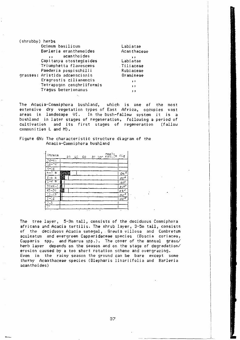
•• ' .
The Acacia-Commiphora bushland, which is one of the most extensive dry vegetation types of East Africa, occupies vast areas in landscape Vl. In thebush-fallow system it is a bushland in later stages of regeneration, following a period of cultivation and its first stages of regeneration (fallow communities Land M).
Figure 6N: The characteristic structure diagram of the Acacia-Commiphora bushland
3-:..2 1 1)0 S'
The tree layer, 5-9m tall, consists of the deciduous Commiphora africana and Acacia tortilis. The shrub layer, 3-5m tall, consists of the deci duous Acacia senegal, Grewi a v i llosa and Combretum aculeatum and evergreen Capparidaceae species (Boscia coriacea, Capparis spp. and Maerua spp.). The cover of the annual grass/ herb layer depends on the season and on the stage of degradation/ ei·osion caused by a too short rotation scheme and overgrazing. Even in the rainy season the ground can be bare except some thorny Acanthaceae species (Blepharis linariifolia ar1d Barleria acan tho i des)
37

0 ACACIA BREVISPICA - ACACIA TORTJLIS The most important species in the Acac:i.a e:ornmuni ties are
tree : shrubs:
MAME: Acaci a tor t i l i s
' ' Acacia
' '
brev i sp i ca sen eg al mellifera
Cassia singueana Ochna ovata Bauhinia tomentosa Adenium obesum Euphorbia nyikae GrevJia bicolor
(shrubby) herbs Canthium phyllanthoideum Dyschoriste thunbergiflora Cyphostemma maranguense Chascanum hi ldebr andt i i
grasses: Tragus berterionanus
FAMILY: Mimosaceae
' ' Mimosaceae
'' Caesal pin i aceae Ochnaceae Caesal pin i aceae Apocynaceae Euphorbiaceae Tiliaceae
Rubiaceae Acanthaceae Vitaceae Verbenaceae Gr ami neae
The Acacia communi ties have the domination of Acacia species in common.
-The first Acacia community occurs at the footslopes bet1,,,een LS IV and LS VI (Unit 6.1). Acacia brevispica forms with Grewia bi col or, Ochna ovata and Cassia singueana a 3-6m tall thicket (see figure 0 1). -The second Acacia community is a Acacia mellifera-Acacia senegal tt-dcket in degraded/eroded areas in LS VI. '"hen i t is cleared this thicket is very susceptible to erosion, because it has no gra=.s /herb layer and the soil lacks organic material. -The third Acacia dominated community forms unit 6.3 near lgambangombe. It is a woodland wi th lOm tall Acacia tortilis trees covering externally 30%. In the understorey , 0.25-lm tall, shr ubs are c:omrnon ( Cant h i Uff1 p hy l l an t ho i deuro and Tri ump het t a f l avescen-:.) .
38

P ALBIZIA ANTHELMINTICA - STERCULIA RHYNCHOCARPA The most important species in the wooded Sterculia r hirn cho car pa bu shl and are :
NAME: trees: Delonix elata
Sterculia rhynchocarpa Albizia anthelmintica Tern1inalia browniî Acacia tortilis Commi phora afr i cana
shrubs: Acacia mellifera Capparis sepiaria Combretum aculeatum
herbs: Dicliptera sp. Barleria eranthemoides Triumphetta flavescens Cissus quadrangularis
rotundifolia '' grasses:Tetrapogon cenchriiformis
FAMILY: Caesalpiniaceae Sterculiaceae Mi rno saceae Combretac:eae Mi rno sac:eae Burseraceae Mimosaceae Capparidaceae Cornbretaceae Acan t haceae
' ' Tiliac:eae Vitaceae
' ' Gr ami neae
The Sterculia rhynchocarpa wooded bushland resembles in structure and in flora the Acaci a-Commi phora bushl and. Onl\• thi s "'ooded bushland has scattered trees wi th well defined trunks which carry the crown above the Acacia-Commiphora canopy. They include Delonix elata, Sterculia rhynchocarpa, Albizia anthelmintica, Terminal ia browni i and Adansonia digi tata, the baobab. The\• attain a height of 10m. Only the baobab can reach 20m.
Figure 6P: The characteristic structure diagram of the Sterculia rhynchocarpa developed bushland at the end of the wet season.
Il~----- ree1" ~-~.,""~ ::".' l:.·"', Eü 3"'- 10·"'. (Xt.CO fig
! '.' '~"__._'-------------'----1 ~.::.
1 0 '
Most of these tree species attracted our attention. The baobab, a 20m tall huge stem succulent, points his mostly leaveless branches to the sky. Sterculia rhynchocarpa is also a stem succulent, although in lesser degree. In the dry season Delonix elata and Terminalia brownii are conspicuous. Delonix elata has beautiful big flowers and Terminalia has red winged fruits.
39
1 'l
.
1
"
I ·l
1
l
l 1 1 ' 1
~

l
1
1
1
J
1
1
1
1
1
1
1
1
1
1
l
1
' i
Q ACACIA NILOTICA - TERMINALIA BROWNI I The most important species in the Acacia nilotle:a Hooded bushland are:
NAME: trees: Acacia nilotica
Termlnalia brownii Bridelia taitense
shrubs: Grewia bicolor Maytenus sp. Canthium phyllanthoideum Pentas parvlflora
herbs: Acalypha lndlca Pentanisia ouranogyne Triumphetta flavescens
grasses:Tetrapogon cenchrilformls Arlstida adscenslonis
FAMILY: 1"1 i ff10 saceae Combretaceae Euphorbiaceae Tlliaceae Celastraceae Rubiaceae Rubiaceae Euphorbiaceae Rubiaceae Tiliaceae Gramineae
' '
The Acacia nilotica wooded bushland is found at the wetter places of Ls VJ. A wet type can be differentiated occuring on tops of hills with a deep soil and in the neighbourhood of Chiokariga near Kijege forest. The dry wooded bu=.hland type occurs in the neighbourhood of seasonal rivers and in former river beds. In both types Acacia nilotie:a and Terminalia brownii dominate in the tree layer of 8-lOm. It is striking to find Combretum zeyheri, a bushland species of Ls IV, se:attered in the 1.Jet t\•pe.
Figure 6 Q1&2: T"•o characteristic structure diagrams of the Acacia nllotle:a deuelope~ bushland. Left the dry, right the wet type.
; tra ta ree 1.1. fig Strata 20 4r, ·60 88 2or. f xt. :::o 20 40 60 80
)2-~I, 32-64 1
~---"><: 16..:.._"lc: 1
'~ -) 6 8-16 1 '1 _p.. m ll1 oir 4 •8 m 1
;- -4 m ozl 2-4 m 1
1-< m 01' l=<' m ';Oc1r. -1 " 101S ;ocm-1 1
=?;-50 1 0 ,. 25-50 1
l :· -r~5 01• 12-25 )-~2 OD r 3-12
• -3 0-3 ,. 0
In the understorey of both types there are annual perennial herbs and lm tall dwarf shrubs (Maytenus Canthium phyllanthoideum).
real ... )QO fX t. :,'.'.O
grasses, spp.and
Perennial grasses (Heteropog•)n contortus) oe:e:ur in the v,1et t\ipe cvhereas leave sue:e:ulents (2 Cissu·; spp. and the Ase:lepiadaceous Caralluma dummeri) are found in the dry type.
40
fi f,
02!
007
a 1 •
c:;·> CZ 6~
lcos-co•
·--------------------~~~--"~~_j__

J
1
1
1
1
1
1
1
J
1
1
1
1
1
1
1
1
R HYPHAENE THEBAICA - CASSIA LONGIRACEMOSA The most important species in the H~•phaene thebaica fallow communi ties are :
NAME: trees: Hyphaene thebaica shrubby herbs:
Cassia longiracemosa Heliotropium subulatum
herbs: Tephrosi a v i llosa Herrnanni a glandul i ger a Acanthospermum hispidum Solanum incanum
grasses: Aristida adscensionis
FAMILY: Palmae
Caesalpiniaceae Boraginaceae Papilionaceae Sterculiaceae Acanthaceae Solanaceae Gr aroi neae
The Hyphaene thebaica fallow communities occur on the river terraces of the Tana river and other perennial rivers in landscape VI. Compared to the fallow cornmuni ties L and M the Hyphaene thebaica fallow comrnunities have a much shorter rotation scherne with a fallow period of only 2-3 years, because on the river terraces the soil is deep and fertile. Cassia longi racemosa and Hyphaene thebaica , the doompàln1, are the characteristic species. Hyphaene thebaica and some other trees up to 12m are spared when cult i vat ing. They are up to 12m tall and cover about 5-10%. In the understorey Cassia longiracemosa, the perennial grass Aristida adscensionis and weeds ( Solanum in can urn and Acan thosperrnurn hi sp i durn) are common between 0. 3 and 1. 5m.
41
J
1
1
1
1
r
1
1
1
1
1
1
1
1
1
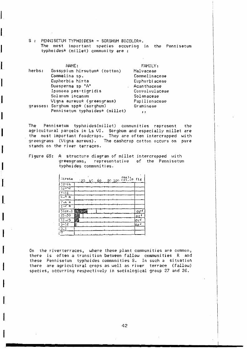
s PENNISETUM TYPHOIDES* - SORGHUM BICOLOR*. The roost important species occurin9 in the Penniseturo typhoides* (millet) community are :
NAME: herbs: Gossypium hirsutum* (cotton)
Commel i na sp. Euphorbia hirta Duo sperma sp 11 A" Ipomoea pes-tigridis Solanum incanuro Vigna aureus* (greengrams)
grasses: Sorghum spp* (sorghum) Pennisetum typhoides* (millet)
FAMI LY: Malvaceae Comroelinaceae Euphorbiaceae Acanthaceae Convolvulaceae Solanaceae Papil i onaceae Gr aroi neae
' '
The Penni setum typ hoi des(mi llet) commun i ties represen t the agricul tural parcels in Ls VI. Sorghum and esp.ecially millet are the most important foodcrops. They are often intercropped with greengrams (Vigna aureus). The cashcrop cotton occurs on pure stands on the river terraces.
Figure 68: A structure diagram of millet intercropped wi th greengrams, representative of the Pennisetum typhoides communities .
. "itrata
1 '?-}f [ "-" ro
. ;Gc:r.-1 1 25-50 l lë-i5 1 )-è2
.; .J-3
On the riverterraces, where these plant con1mun1 ties are common, there is of ten a tr an sit ion between f al low commun i ties R <ind these Pennisetum typhoides communi ties S. In such a si tuation there <ire agr i cul tur al crops as well as r i ver ter race ( f allo1-1) species, occurring respectively in sociological group 27 and 26.
42

1
1
1
1
1
1
1
1
1
1
T LAHSONIA INERMIS - SPHAERANTHUS SP. The most important species occurin9 in the Lawsonia inermis wadi communities are:
NAME: shrubs: Lawsonia inermis
Acacia nilotica herbs: Sphaeranthus sp.
Kohautia caespitosa Indi9ofera tinctoria Heliotropium subulatum Calotropis procera
grasses: LISP 9
FAMILY: Lythraceae Mimosaceae Compositae Rubiaceae Papilionaceae Boraginaceae Asclep i adaceae Gramineae
Lawsonia inermis, a 3m tall evergreen shrub is in and along the wadis the charactei-istic species. It also occurs at very small seasonal rivers. Along the wadis Acacia nilotica is the only Acacia shrub. Generally the shrub is a riuerine species.
Fi9ure 6T: A structure diag1·am of a hillock in the t.Jadi covered with Lawsonia inermis and Acacia nilotica shrubs.
-·- 1
')<: :..-_ _, -"·-oo•
. ' - __ ,
It is striking that the herbs have mostly woody sterns (Kohautia caespitosa and Indigofera tinctoria), an adaptation to protect themselves against streamin9 water. Calotropis procera, an Asclepiadaceous species, can survive in the wadi on sandy places as i t survives at the edge of sandy roads in landscape VI. There is a transi tion in the wadi from very dynamic to more statie situations; together with this the sand is becoming more fine. In these transi tions, there are ofter1 small cliffs, diuiding small plateaus at several altitudes. In Arabic countries Lawsonia ir1ennis, the 'henna' plant, is used for dying the hair and painting hands and feet.
43

--
U COMBRETUM SP. - COMMIPHORA AFR!CANA The most important species in the Commiphora africana Scrub forest are:
trees: shrubs:
herbs:
grass:
NAME Commi phor a afr i cana Combretum sp. Acalypha fruticosa Triumphetta flavescens Oei mum basilicum Ecbolium hamatum Dactyloctenium aegyptium
FAMILY Burseraceae Combretaceae Euphorbiaceae Ti li aceae Labiatae Acanthaceae Gr ami neae
The Commi phora af r i cana shrub fores t occurs in Ls VI 1 in the Nyamatu hills and near Mumoni forest. In this forest Commiphora afr i cana, a Combretum species and Acalypha fru t i.cosa are the most common species. These species form sociological group 29.
Figure 6U: The characteristic structure diagram of the Commiphora africana shrub forest.
i Sttata ree1T
40 60 8~ lOC PX"t.CO fi~
25-50 1 o;J
lê-25 1004' 3-:2 ' -0
The deciduous Commiphora africana forms the upper layer of 10-12m I ts ex ternal cover is 40%. The in ternal cover depends on the =·eason. Structure diagram 6U was made in the dry season. 1 n the «Jet season the real cover of the upper la\'er is (04x07=) 28%, instead of (04x04=)16% The Combretum sp. wi th medium sized evergreen leaves (mesomorph) dominates in the shrub layer of ?m. The dec:· uous Acalypha fruticosa is abundant in the lower shrub layer of :.5-4m. Strikin9 features of this shrub forest are the poverty in plant species, the dominance of 3 species and the absence of special live-farms such as lianas, thorns and ·succulents. It is easy to walk ttwough this forest without stooping and being pricked by thorns.
44

V USP 10 - OCHNA OVATA The most important species occurring in the Ochna ovata Scrub forest are:
NAME: FAMILY: trees: Ochna ovata Ochnaceae
Acacia brevispica Mimosaceae Cordi a ovali s Bor agi naceae Commiphora bo i v i ana Burseraceae
' ' holtziana ' ' USP 10
shrubs & lianas: Premna olichotricha Verbenaceae Capparis tomentosa Capparidaceae Bauhi n ia tomen to sa Caesalpiniaceae Dalbergia lactea Papil i onaceae Boscia angustifolia Capparidaceae USP 11 (liana) Papilionaceae
herbs: Crabbea velutina Acanthaceae I soglossa laxa
" Ecbolium hamatum ' ' Rhinacanthus gracilis ' ' .Leucas glabr ata Labiatae Commel i na sp. Commelinaceae
ferns: Pellaea longipilosa Pteridophytes Actiniopteris radiata
' '
The Ochna ovata shrub forest is found on the mountains of landscape VII; Kijege forest and Kierere forest in the northeast and Mumoni forest in the southeast of the survey ·area. The Ochna ovata shrub forest is a result of a law which 1,;as passed 40 years ago to pro tect the area agai ns t erosi on. Thi s lat~
forbade people to live on ~he mountains. Witness of the past (over) landuse are the big erosi on gull i es i r1 Mumon i f or est and the vegetation itself. The vegetation is dense and complicated. It is difficult to know from which stem a leave originates by the many 1 i an as and in ter twi n i ng bushes. Ochna ouata, a low growing tree wi th small leather like evergreen leaves, is very common and often dominating. Acacia brevispica is everywhere but never dominating. In the understorey 0.25-0.75 m tall Acan thaceae herbs are most common. Cordia ovalis, Commiphora boiviana, Commiphora holtziana, USP 11 (a Papilionaceous liana with big deciduous leaves) and USP 10 (a big tree, with a winged stem and older than 40 years) occur only in Mumoni forest. In Kijege forest two fern species are common.
45
1
1 1
' 1
1 ' 1
1
1
1 1 1 1
' 1
i
l 1 l i
t 1 ~

1
1
1
1
1
1
1
1
1
1
1
Figure 6V: The characteristic structure diagram of the Ochna .ovata shrub-forest in the dry season.
St!"ata
>=-}é 1.;._.g c
?-4 :: l-C:: ::
;oer.:..: 25-5C .:..:::-.-.;
3-:.2
0
20 i.:.C. 60 :-ea]" -''--• :!-': :0·~ t"X~.'.:°O
loot-loor 1-
1 n the s tructure diagram whi ch t-•as made in the dry season os4 · the two highest layers was found, which shol;lld be at least O~~ in the rainy season. In the second layer 03' is found, because the evergreen bushes and shrubs do not change much in cover per season ( Ochna ovata, Cap pari s tomentosa, Bosci a angus t i f ol ia and Bauhinia tomentosa).
46

4.4 Description of the mapping units
1 Ocotea usambarensis - Strombosia scheffleri Ls
Climate and Soil This Landscape is situated in the north-western part of the study area between 2100 and 1600 meter. Several hundred meters higher (outsi te our area) i t borders the Bamboo zone. lt is the wettest part of the area with an annual rainfall of 1800 - 2200 mm. The area is covered by several lahar flows (flow of a heterogeneous mixture of lava with mud), forming several layers causing a step-like appearance. Soils are deep-weathered Nitisols, with an decreasing humous topsoil 9oin9 downstairs.
Past, Present and Future The majority of the forest is still virgin and differs not much from the forest in the past. The forest border (mapping unit 1.3) and the forest near the tracks haue been heavily exploitated. Fo1·estry has practised intensive selectiue felling to cut timber trees like Campher (Ocotea) and Podo (Podocarpus)~ Only near the tracks suitable trees are cut, not beyond the fir•t deep valley. Near the tracks useless trees are left (often secondary species like Croton sp. or very old Camphers). Individual people are allowed to cut trees for fuelwood, which they gather in the lower parts of the forest. Al so farmers ~Ji th thei r nei ghbour i ng shambas put pressure up on the forest. They slowly moue the forest boundary back to start profitable tea plantations. Quite recently the Kenya government decided to allow farmers to move 100 meter in to the forest, The gouernmen t mo ti uated thi s deci si on by say i ng that the new plantations will provide a buffer between squatters and the forest (Redfern 1985).
Mappinq units
1.1 Podocarpus milanjianus - Galiniera coffeoides Vegetation types: A (80%), B (20%)
1. 2 Oco tea usambarensi s - Strombosi a scheff ler i lv'egetation types: 8 (80~n, A (10%) and C (10.~)
1.3 Prunus africana ~ Celtis africana Vegetation types: C (80%) and B (20%) Most influenced part of the Forest
1. 4 En se te ven tri cosum - Newton ia buchan i Vegetation types: c·(70%), 8 (20%) and A (10%) Only in the steepest valleys a different vegetation can be found (with slopes of over 100%). A large part of this unit is covered by the Prunus - Cel t is veg, type c~i th a Newton ia buchani Woodland along the rivers. Higher in tr1e Forest also uegetation types 8 and C occur. On the steepest slopes with shallow soils wild bananas (Ensete) and tree ferns (Cyathea sp. ) occur.
47

1
1
1
1
1
1
1
1
1
1
1
1
1
1
----
2 Croton megalocarpus - Coffea arabica Ls
Climate and Soil This landscape stretches from the boundaries of the Rainforest to the Combretum Woodland and spans an area wi th an ave1·a9e annual rainfall of 1200 - 1600 mm. Ecological more important is the length of the growi ng season. In the dry season in the 'Teazone' (which overlaps partly unit 2.1) the top soil contains s t i 11 more than 30% mo is ture (wei ght) . Only the upper few centimeter are dry. Downstairs in the area near Ls 3 this moisture content in the topsoil is less than 15%, too dry for most plants to grow optimally.
Obviously the soils in the cultivation area near the Forest have a darker topsoil than the soils in the lower part. Going down soils get more structure, shiny pedf aces are pronounced and f i nally, in the extreme eas tern part, the so il s are less deep.
Past,· Present and Fu ture The area near the Rainforest (at least unit 2.1) are quite recently (last century) deforestated. There used to be a forest like the Prunus africana - Celtis africana vegetation type. Wi th a population growth of 3-4% this landscape i.•ill change rapidly. Especially in unit 2.2 this might have tremendous efects when the present ecologically adapted landuse system has to change (see unit description).
Mappinqunits
2.1 Pteridium aquilinum - Camellia sinensis Vegetation types: D (85%), El and E2 (10%) and C (5%) The highest and wet test part of landscape 2 wi th a very typical landuse which is reflected in the name t4hich Jaetzold giues for this agro-ecoloigical zone: Tea - Dairy zorie. Near the homesteads, on the ridges, there are small pastures and gardens with foodcrops (maize, beans). On the vallei• slopes tea plantations are si tuated.
2.2 Croton megalocarpus - Coffea arabica Veg. type El and E2 (80%), c, D and F (20%) One of the most extended mapping units with a lot of variation in slopes, valleys and landuse. However a majc<r component is the typical building block of this landscape. Farmers grow their foodcrops near the homesteads on the ridges; coffee is planted on terraces on the often steep slopes; on the valley bottom bananas are planted. Especially near the homes teads trees are abundant ( E2).
2.3 Eucalyptus camaldulensis - Pinus raddiata Plantation forest which was planted ± 20 years ·ago
48

-
2. 4 Al bi z ia gummi f era - Newton ia buchan i Vegetatlon types: E 1/2 (50%), C (30%) and D (20%) Valleys with still an abundant tree vegetation, remnants of the farmer forest and comparable to the lower part of unit 1.4. Often forest is earlier cleared on the ridges than in the valleys.
2. 5 Albl z ia gummi f era - Newton ia buchan i Vegetation types: E 1/2 (50%), D (40%) and C (10%) The whole valley is cultiuated but remnants of the forest can be found along the rivers.
2.6 Musa sp. - Coffea arabica Vegetation types: E 1/2 (100%) Smaller valleys where even cult i vat ion, mai nly ban an as, is practised on the banks of the streams.
3 Dombeya rotundifolia - Hangifera indica Ls
Climate and Soil Subhumid climate, with an annual average rainfall of+ 1100-1300 mm and two long dry seasons. Nitisols dominate in the western part of this landscape, Acrisols dominate in the eastern part of this landscape.
Past , Present and Future In the past there was a forest, much opener and 101A•er than the present Rainforest. Tm-Jards the east this forest gradually became a kind of f~oodland wi th more drough resistent trees. Al though the land pressure is uery high, small ·areas can be f ound with a fallow vegetation of five or more years (veg. type H). But the majority of the land is cultivated,with in contrast to the previous landscape, falloi,_1 periods of up to two years (grass- or weed f allow) .
Mapoinq units
3.1 Mangifera indica - Zea mays Vegetation types: F (7föi), E 1/2 (25%) and G (15%)
3.2 Dombeya rotundifolia - Mangifera indica Vegetation types: F (50%), El/2 (30%) and G (20%)
3.3 Lantana camara - Zea mays Vegetation types: G (40%), F (30%) and E 1/2 (30%)
3.4 Albizia gummifera - Newtonia buchani Vegetation types: F (50%), E 1/2 (30%), C (10%) and G (10%)
3.5 Musa sp. - Zea mays Vegetation types: F (60%), El/2 (30%) and G (10%)
49

4 Combretum zeyheri - Combretum binderianum Ls
Climate and Soil The majori ty of this landscape is sub-humid wi th an average annual rainfall of ± 900-1200 mm and a prolonged dry season. The majority of the soils are qui te deep Acrisols with a moderate fertili ty and moderate physical properties. But near the edge of the plateau (in the southern part of the area) they become much shallower and gr avell i er. Wi thi n one meter depth murm (iron manganese concretions) can be found and finally the last kilometer of the plateau, the soils bee:ome less than 20 cm deep (lithosols). Although the majority of this landscape is of volcanie: origin, in some valleys Basement System roe:ks are the parent material for soil genesis, causing many similari ties wi th landscape 6.
Past, Present and Future Especially north of the Thuchi river (Meru district) this landscape is qui te extended. It is relatively undisturbed, whie:h is striking when going down · the slopes of Mt. Kenya through it's intensively cultivated land (landscapes 2, 3 and 6). This can be explained by it's buffer position between the countries of different (sub) tri bes: the Chuka ( hi ghlands, Ls 2 and 3) and the Tharaka (lowlands, Ls 6) people. Only recently this area became safe enough to start cultivation, but it's population density is still low. The uegetation is influenced by an extensiue burning
.regime which caused the dominance of Heteropogon e:ontortus but saued the tree layer (in contrast to Ls 5). In future mue:h more cultivation will be practised in the northern part of the landscape, in the southern part most of the sui table places are already cultiuated. A grazed Bushland is left, offering little opportunities to cultivate due to it's uery shallow soils.
Mapping units
4.1 Combretum zeyheri - Heteropogon contortus Vegetation types: H (70%) and F (30%)
4.2 Combretum zeyheri - Zea mays Vegetation types: H (50%) and F (50%)
4.3 Aloe secundiflora - Euphorbia nyikae
4.4 Heteropogon contortus - Euphorbia nyikae
4.5 Zornia apiculata - Ocimum basilicum On some places flo1-.1s of Lahar streamed further away from Mt. Kenya. One of these probably reached a depression in the Basement System and formed a plain. Developed soils are very shallow and moderately fertile. North of the Chukasou th area thi s landscape is much more common. Thi s area is heavily grazed and the shrubby herb Ocimum basilicum and Heteropogon contortus (grass) dominate. Zornia apiculata
·, is an indicator of heavy 9razin9 pressure.
50

Spots of heavy clay soils (Vertisols) occur, developed poorly drained environment as can be expected on these areas. Here a qui te different vegetation can be found In the dry season grazing cattle and goats concentrate the green vegetation,which grows on these spots.
4.6 Combretum zeyheri - Terminalia brownii Vegetation type: J (100%)
in a flat ( K) •
on
Thi s Woodlarrd is f ound on the Mater i basalt Plateau and on the Plain of lahar, where also unit 4.5 is si tuated. Both locations are surrounded by Landscape 6, which illustrates the importance of the parent material ( the assumption of the same climatic circumstances seems to be realist ic). Compared to unit 4. 5 thi s unit has a much less humani nf luenced vegetation type (especially burning).
4.7 Euphorbia nyikae - Acacia brevispica Vegetation types: F (60%), G (20%) and 01 <.20%) Valleys wi th locally shallow soils, which are partly de1·ived of Basement System rocks having it's influence relativelly far to the west.
4.8 Combretum binderianum - Combretum zeyheri Vegetation types: H (40%), G (30%) and S (30%) Mo Basement Sys tem i nf luences
57;

1
J
1
1
l
l
1
5 Hyparrhenia sp. - Heteropogon contortus Ls
Climate and Soil Volcanic influences no longer dominate in tr1e tr1ree eastern landscapes. This change in geology goes together with a steadily decreasing amount of rainfall, in this landscape± 1000 mm a year. Thi s landscape occurs only in the nor th e>as te>rn part of the> Chuka - south area and has slopes of over 20%. Soils are moderately deep, often with murm •
Past, Present and Future Probably this landscape used to be covered by a kind of Bushland, more or similar to unit 5.1. Fire is the main factor which has caused thi s Wooded Gr assl ar1d. The f i re tol er an t Heteropogon con tor tus domi nat es here. The high bi omass, ~Jhi ch is burn t and the time of burning (just before the onset of the rains) causes hot fire, which is reflected in the low tree coverage. Due to the steep slopes, shallow soils and demog1·aphic factors (see Ls4), this landscape has never been cultivated to any extend. Only on a few suitable spots and near the transition to the o ther landscapes ( especially the f oo tslopes) cult i vat ion is possible.
Main landuse i~- grazing (mainly cattle). During the dry season the Hilis are covered by a layer of "standing hay" with a uery low foodquality. Only below the irritating needles of Speargrass (Heteropogon contortus) some fresh leaves can be found or the nutricious le>ave>s of Indigofera binderi. However af ter burning during the rains a layer of green fresh grasses is formed, which is very palatable and nutricious. Till the flowering of Speargrass the Hyparrr1enia sp. - Heteropogon contonus Ls is heavily grazed. During flowering (dry season), the animals shift to the valleys and landscape 6 •..Jhere browse forms an important dry season forage resource.
Mappinq units
5.1 Gardenia jouis-tonantis - Heeria reticulata Vegetation typei: O (90%) and l (10%) Vegetation type Q is dominant, but some open (especially in the Mutharanga forest near Chiokarige) Fire is not important, only the fringe of the scrub is regular ly burned. Thi s is the only gr azed part unit.
5.2 Heeria reticulata - Heteropogon contortus Vegetation type: l (1001~)
5.3 Gardenia jouis-tonantis - Heeria reticulata Vegetation types: O (g0%) and l (10%)
5.4 Hyparrhenia sp. - Heteropogon contortus Vegetation type l (100%)
52
places occur. fores t
of the

! !
' 1 i
1
!
i __ _
. ·- -- -
6 Acacia senegal - Commiphora africana Ls
Climate and Soil This landscape occupies most of the eastern part of the Chukasouth area, the lowest and driest part of this area with an annual average rainfall of 600-900 mm. 1 t belongs to the Basement System which stretches several hundred kilometers to the east and is covered by an endless sea of thornbush. Each part of thi s area has once been cultivated, therefor vegetation is a reflection of the stage in the bush-fallow system.
The majori ty of the soils are Chromic Luvisols, developed of gneisses rich in ferro-magnesium minerals, which are qui te deep and moderate fertile (chemica!) but have a very low organic mat ter content. They are all eroded and ha,•e lost thei r humous topsoil. This caused the sealing of the exposing subsoil, which reduces the infiltration capacity very much (often more than 50~; of the rainwater runs off!). On spee:ific places, near rivers and streams, Calcic Luvisols occur compa1·able in chemical fertili ty to the Chromic Luvisols. However surface sealtng does not occur here. Especially near the Mountains and Hills other soils occur, formed of colluvium. In the river terraces·quite different soils occur, of which the parent material is both of volcanic and Basement System origin. These alluvial soils are deep, relatively fertile and have a good physie:al structure.
Past, Present and Future In 1938 Maher, then soil conseruation officer for Kenya wrote a report about Emqu district based on four weeks of field investigations. He wri tes about the Acacia senegal - Commiphora africana landscape: "Bare grani tic 1·ocks and scanty sands in semi-arid country situated at low altitudes reflect back a pi tiless sun. Stunted animals and poverty-strie:ken inhabi tants seek sustenance in a banen semi-desert where all hope of progress is fut i le and where f amine is ever t.•ai t i ng at the door -the most promising method of dealng with these people appears to be to move them, loek, stock and barrel, leav i ng thei r present land to regen er ate to bush and to become once agai n the haun t of the elephant, the rhinoceros and the buffalo - abandonment of the land to the slow but sure healing of Nature is the only praticable remedy'.(Maher, 1938, 1,'ol.1:2; Vol.l!:l,64, quoted by Brokensha and Riley 1980)
Nearly fifty years later the physical si tuation seems to be much the same. A newspaper wrote in an article about new funds which are provided for the EMI programme to help farmers in the dry par ts of Embu, Meru and J si olo dis tri cts. They wr i te abou t the area:'to assist (the farmers) with the task of earning a living from some of Kerwa's poorest and most arid land - to prevent further deterioration of the arid land and to boost agriculture, forestry and livestock product ion - They were hard hit by the drough last year and the population exploitation in Kenya has forced farmers to use the land more extensively wi th the resul ts that the soil does not recover' (Nat ion; januari, februari 1986) No discussion has to be held about the severity of the
53
"
1

1
1
1
1
1
1
1
1
1
1
1
1
1
1
1
1
--- .
degradation, but the report of 1938 leads to the posing of questions about the rate of it. Due to the availability of permanent water and easily exploitable land, this landscape has been cultivated already a long time ago. Shor tly af terwards degradat ion became more serious till the situation in 1938 and nowadays.• The situation before cultivation started can be reconstructed:
Older people remember the times (more than 50 years ago) that the northern part of this landscape (Tharaka, in Meru district) was cc0 vered by forests wi th hl gh trees and harboured abundant wildlife of lions, giraffes and antilopes. Especially the footslopes of the hills and mountains were covered by a Woodland of tall Acacia tortilis trees (mapping units 6.1 and 6.2). Remnants of the=-e can still be found near Kijege forest.
Probably the majority of the area (mapping units 6.4 and 6.5) was covered by a vegetation which nowadays can be found in Meru National Park, 40 Kilometer north-east of the Chuka-south area. Uncul tivated land remains there under comparable climatic and pedologi cal condi t i ons. Four lay ers can be dl s t i ngu i shed in the vegetation:
A ground layere 0 - O.Bm. wi th perennial grasses, especially Chloris roxburghiana and Enteropogon macrostachys.
A shrub la)-;er 1.2 - 1.7rn. with Grewia villosa, Cornbreturo aculeatum, Bauhinia taitensis and Triumfetta flavescens.
A high shrub or low tree layer ± 5m. with Commiphora africana, Acacia senegal and Acacia tortilis.
A tree layer ± 15m. c>1ith Acacia tortilis.
Here the humous top soil is± 25 cm thick in which all rain water can i nf il tr ate. However al so in thi s pro tected area spots of bare soil occur t-•i th species common in cultivated land, like Ocimum basilicum, Tetrapogon cencriiformis, Tragus berteronianus and even Blepharis linariifolius. They occur where animals gather, like tracks, elephant pools and on old termite mounds. This illustrates the sensi tivi ty of the ecosystem to erosion. The humous topsoil is lost exposing a subsoil which is easily sealed, causing a low infiltratior1 capaci t". Perennial grasses disappear and can be replaced by annual grasses, but more often they are replaced by a den se shrub lay er. · Thi s is the so called bush encroachment.
54

1
1
1
1
1
1
1
1
1
1
1
1
1
1
1
1
1
1
1
1
Present Landuse In the majority of the area a bush-fallow agriculture is practised. People start cultivation by clearing a particular bush, usually a few ha large. Not all trees are cut, especially Sterculia rhynchocarpa, Delonix elata and Adansonia digitata are spared, Commiphora and Acacia trees are often only cut remaining a one meter high stem. A few months after clearing all biomass is burned, usually just before the expected onset of the rains. Cultivation starts with as major foodcrops millet, sorghum and green grams and most important cash erop cotton. On spots receiving more rain, cotton is grown. Usually the gardens are protected against livestock by fences of thorny Acacia senegal or A. tortilis branches, but after the harvest in the harsh dry season animals are driven into the gardens to graze weeds and millet or sorghum stalks.
After two or three years of cultivation, land is left fallow. The first year only heavily grazed annual grasses and herbs grow. Trees which were spared during cultivation grow out and are the spots of a slowly recovering vegetation. Dependant of the amount of depletation of the soils and the grazing pressure, re9eneration can occur, or not. In the latter case the land remains bare, soil surface seals and any regeneraton will be very unlikely. The situation is often worsened due to grazing animals for which this area is very attractive.
The regenerating land slowly grows out of reach of cattle and goats and 'shoots' then several meters high. First i t farms dense thickets, but becoming older (more than 10 11ears?) trees grow higher and a kind of Scrub forest is formed (7m high trees). This s ta9e is har dl\' reached anymore, because bef ore that moment t1·ees are already cut for a new cultivation stage. Nowadays especially the transi tion from bare soils wi th outgrowing trees in to bushland is gradually hindered. More exhausted soils and a higher 9razin9 pressure are respons! ble for thi s" Al though landdeari ng as such is not accelerating, the amount of older A. senegal-C. africana bush decreases due to a decrease in developing of bush after cultivation. In a first visit one would be inclined to think that this ecosystem is deterio'rating. We have already seen that the way and the rate show that new 'equilibria' are formed. This means that overstrained measurements (like abandoning land, destocking etc) ~~ill not solve anything. No clear solutions can be offered but a few ideas are discussed elsewhere (Scholte '86b). The situation on more fauourable sites like the river terraces is quite different, see under unit descriptions for more details.
55

Mappinq units
6.1 Bauhinia tomentosa - Acacia brevispica Vegetation type 0 (100%) Thicket and Bushland on the footslopes of the scarp between Ls 4 and 6. This rather luxuriant vegetation contrasts with the spar se vegetation upwards (unit 4.3). Here the moisture availability is very high due to seepage of groundwater from the plateau.
6.2 Commiphora holziana - Commiphora africana Vegetation type N (100%) Mainly 8crubforest on a ridge in the centre of this landscape
6.3 Acacia senegal - Commiphora africana Vegetation typ2s 01 and 02 and P On a fel4 places extended areas of Bushland and J,.foodland can be found. This unit is very heterogenous, the majority consists of relative old bushland
6.4 Pennisetum typhoides - Commiphora africana Vegetation types: N(25%) ,8(20%) ,M(20%) ,P(15%) ,0(15%), F(5'!.) The most common mapping unit in this landscape
6.5 Pennisetum typhoides - Commiphora africana Vegetation types: N(40%), M(30%),8(20%), In many aspects comparable to unit conspicuous chess-board form of thicket
P(5%), L(5%),F(5%) 6.4, but not the and farmland
6.6 Pennisetum typhoides - Aristida adscensionis Vegetation types: 8(30%), N(30%), M(20%), 0(20%)
6.7 Pennisetum typhoides - Acacia tortilis Vegetat ion types: S( 40%), 0( 30%) , M( 15%), Farmland with Acacia tortilis Woodland courses and in gener al a high tree cover.
6.8 Terminal ia brot4ni i - H11phaene thebaica
L(15%) along the t4ater
Vegetation typeé: N(30%), 8(20%) 1 0(20%), Q(20%), M(10%)
6.9 Pennisetum typhoides - Gossypium sp. Vegetation types: S (50%), L (30%), M (10%) In many- aspects thi s unit reserobles the nex t one, bu t i t is not situated on a riverterrace.
6.10 Tephrosia sp.- Cassia longiracemosa Vegetation types: 8(60%), L(30%)and R(10%) Along sever al r i vers extended r i venerr aces formed, which due to their fertili ty are all cultiuated. The majority of this unit is cultivated or fallow (usually less than 2 year). patches of less intensively used land occcur.
56
have been intensively
presently Only small

--
6 .11 Acacia rovumae - Cas si a longi r acemosa Vegetat ion types: S( 40~~), L( 30%), R( 25~0 and T( 5%) Along the Tana ri ver extended r i verterr aces r1ave been formed. In the south i t is dissected and has a slope of ±5%, in the northern part it is flat and younger. The majority of this unit has been cultivated with short fallow periods ((5 years). The only older vegetation can be found on the banks of the r i ver whi ch are covered by a hl gh Hoodland. Acacia rovumae and Ficus sycomorus dominate in the southern part, Acacia elatior, Hyphaene thebaica and Ficus sycomorus dominate in the northern part. In the upper northern part of this unit a small island of ± 5 ha in the Tana river is situated (near the Grand Falls). A riverine forest is developed with the same species as on the riverbanks together with Pandanus and Phoenix palms.
6.12 Acacia mellifera - Acacia senegal Vegetation type: 02 (100%) Old riverterrace wi th Bushland, 5 m high, v,1i th a very low ground cover due to the heavy grazing pressure.
57

1
1
1
1
1
1
1
1
1
1
1
1
1
1
1
1
1
7 USP 10 - Ochna ovata Ls
Climate and Soil In the extreme eastern part of the Chuka-south area a range of mountains is si tuated, which rises more than 500 m above the surroundings. This altitude causes a lifting (eastern) air which is responsible for a nearly doubling of the annual rainfall (1200 •Jersus 700 of the surroundings). Of ten clouds were seen hanging around the summi ts of the mountains. They reduce the amount of evaporation and cause condensation at the vegetation. Soils range from shallow to moderately deep (especially on the footslopes), their fertili ty is moderate, In the footslopes soil moisture conditions are relative favourable.
Past, Pre~.ent and Future People living near the Kijege - Kiere Forest range remember the times that the presently uninhabited Mountains were densily populated and in ten si vely cult i vated. Baobabs (Adanson ia digitata) were the only trees which remained. These Mountains were especi ally at tr act i ve dur i ng the times that nomads crossed the area and the people fled into the Mountains and sta\1ed there long after. In 1945 the Bri tish colonial goverment decided to protect the heauily exploitated Mountains and forbad all cultivation and inhabitation of these Mountains (except the Kibiro hills). Most people t.iere chased away, but a few could escape the British. Kijege was one of them. He was a wi tch doctor, who could make himself invisible with special herbs and could continue to live in what is now called Kijege Forest. His son is still living in Chi okar i ge.
Striking is that after independance (1963) the forests remained unoccupied in contrast to an overall tendency in Kenya to neglect colonial anti-erosion measures. Up to the moment no cultiuation and gr az i ng has been pr act i sed in these gazet ted Moun tai ns. In these 40 years a den se Scrub Fore·;t developed above whi ch baobabs rise, remnants of the cultivation land. The Ki bi ro hi 11 s whi ch 1A•ere never gazet ted (why?) probably show the si tuation of all .the Mountains befo1·e gazetting. A stone-rich bare soil with an occasional shrub and no cultivation anymore. Only some grazing is practised by herds of people living near the Tana river. The boundary of the gazetted forests can be found back as sharp lines in the landscapes. On some spots i t looks like a fire lane. Long before the time of cultivation, these Mountains were covered bi1 a high forest. Especiall\' on the higher slopes this might have resembled the Mt .Kenya forest. Nowadays only on the highest peak of Mumoni forest "real' forest can be found (less than 5 acres). Due to it's inaccesibility we could not visit it, but it is possible that vegetation types like Prunus africana - Celtis africana occur there.
58

1
1
1
1
1
1
1
1
1
1
1
1
1
1
1
1
1
r
h
Not~adays the majori ty of this Scrub Forest is formed by the Ochna ovata- Acacia brevispica vegetation type, characteristic for a recover i ng environment wi th a not too shallow so il and slopes of less than 50%. Baobab trees form the upper layer (15m high). On steeper slopes other vegetation types occur. On the top of rock-faces (with a uery shallow soil) Euphorbia nyikae is dominant together "'i th some Commiphora trees. Under these rockfaces a dense tt-.icket, evergreen , ± 1.5 m high of an unknown species stands , benefit t i ng of the avai labi l i ty of rai n water running of the rocks.
Mapping units
7 .1 Ochna ovata - Acacia brevi sp i ca Vegetation type: V (100%) The majority of this landscape is formed by the USP 10 -Ochna ovata ueg. type which occurs on tr1e slopes. On the footslopes an Acacia tortilis Woodland can·be found. Patches of grassland occur, especi ally on the "'es tem si de of the range. They belong to the H)iparrhenia sp - Heteropogon contortus uegetation type, indicating that since the gazetting burning has been practised on a small scale.
7.2 USP 10- Ochna ovata Vegetation types: U (80%) and U (20%) The Scrub forest on Mumoni mountain differs from that of Kijege in having a slightly different species composition. Especially the presence of USP 10 (unknown species), a tree t~i th a winged stem was obuious. The majori ty of the footslopes have been cultivated in Mumoni forest, however no open patches occur. On the peak of Mumoni (1700 m) Mountain Rainforest occurs.
7 . 3 Can t h i um ~· hy 11 an to i deum - Bo er hav i a er ec t a Vegetation type M (100%) The only not gazetted "forest" shows clearly the effect of pro tect i ng dur i ng mo1·e than 40 years, al though one has to realise that protecting the Mountains increased the pressure on this Hill. Why the colonial gouerment excluded this Hill is not clear. Nowadays i t is covered wi th a spar se f al low vegetation and a few scattered bushes of Balantes aegyptica.
59
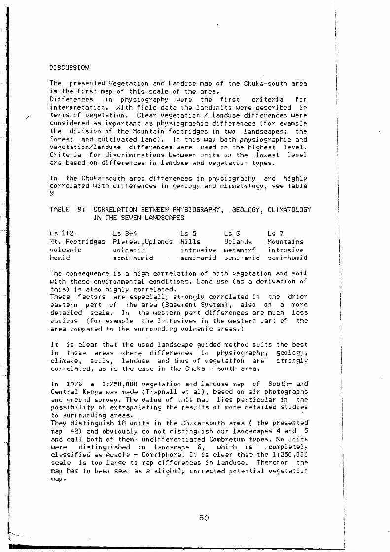
DISCUSSION
The presented Vegetation and Landuse map of the Chuka-south area is the first map of this scale of the area. Differences in physiography were the first cri ter ia for interpretation. With fièld data the landunits were described in
1 terms of vegetation. Clear vegetation / landuse differences were con si dered as important as physi ogr aphi c dl ff eren ces ( f or example the division of the Mountain footridges in two landscape&: the forest and cultivated land). In this way both physiographic and vegetation/landuse differences were used on the highest level. Criteria for discriminations between units on the lowest level are based on differences in landuse and vegetation types.
In the Chuka-south area differences in physiography are highly correlated wi th differences in 9eology and climatology, see table 9
TABLE 9: CORRELATI ON BETWEEN PHYS!OGRAPHY, GEOLOGY, CL!MATOLOGY IN THE SEVEN LANDSCAPES
Ls 1+2· Ls 3+4 Ls 5 Ls 6 Ls 7 Mt. Footridges Plateau,Uplands Hills Up lands Mountains lJolcanic volcanic in tru-:.i ve metamorf intrusive humid semi-humid semi-arid semi-arid semi-humid
The consequence is a high correlation of both vegetation and soil with these environmental conditions. Land ·use (as a derivation of this) is also highly correlated. These factors are especially strongly correlated in the drier eas tern part of the area (Basement Sys tem) , al so on a detailed scale. In the western part di fferences are much obvious (for example the Intrusives in the >Jestern part of
rr1or e less
the area compared to the surroundi ng volcanic areas.)
It is clear that in those areas climate, soils, correlated, as is
the used landscape guided method sui ts ~Jhere differences in physiography, landuse and thus of vegetatton are the case in the Chuka - south area.
the best geology, :.trongly
In 1976 a 1:250,000 vegetation and landuse map of South- and Central Kenya was made (Trapnall et al), based on air photographs and ground su1·vey. The value of thi s map lies parti cular in the possibility of extrapolating the results of more detailed studies to surrounding areas. They distinguish 18 units in the Chuka-south area ( the presented map 42) and obviously do not distinguish our landscape& 4 and 5 and call bo th of them · undi ff eren t i ated Combretum types. No units were distinguished in landscape 6, which is . completely classified as Acacia - Con-<~iphora. lt is clear that· the 1:250,000 scale is too large to map di ff ere;nces in landuse. Theref 01· the map ha:. to beE-n seen as a slightly corrected potential vegetation map.
60

1
1
1
1 1
~·· 1
1
L
[
L
' t
LITERATURE
Acland,J.D. 1971. East African crops. Longman, London.
Do i ng ~ H. 1.982./83. Syllabus colleges Resionale vegetatiekunde. Vegetatiekunde en Plantenoecologie. Agricultural University, Wageningen.
Gi!s.H.A.M.J.v. & Zonneveld,I.S. 1982. Vegetation and rangelant survey. Lecture ~otes ITC. Enschede.
I 1Jens, G .l ... J. 1967. East African Weeds and Their Control. Longman, London
Jaetzold ,R. & Schmidt,H. 1983. F.arm roanagernent handbook of Kenva. Vol. II l'Jatural c:onditions and farm rnanagen-1ent information. P-::a!·t C East Kenya (Eastern and Coast Provinces). Ministry of Agriculture, Nairobi.
Lind,E.M. & Morrison, M.E.S. 1974. Eas.t African Vegetation. Longrnan,London.
Oostveen, M.J. van 1986. Phytogeographisch onderzoek op de
en eio:=.tflank
vergelijkend van Mount Kenya
vegetatiekundig tu:.sen 600 en
3000m. Internal report Wageningen. Redfern, M. 1985. Kenya's forests uprooted for tea plantations.
t··.Jei--1 Se: i ent is t , 21 febr. '85 Scholte, P. 1986a.
Grazing in the Ishiara map ·::.heet • Internal TPIP,Wa9enin9en.
Sc:holte, P. 1986b. Sealed red soils in Eastern Kenya. Internal report l.-·Jagen i n·3ET:.
Trapnell, C.G., Sirc:h, W.R.., Brunt, M.A., t !...a1,Jton, R.~··1. !...Je'3e-:::ation and L.anduse Sur~,e~J of S.~~. Kenya,sheet 2 Governmental Printer.
Weg, R.F. u. 1978.
report
TPTC' '' ", '
Definitions of land forms in relation to soil mapping and map legend construction. Internal communication nr. 13. Kenya Soil Survey, Nairobi.
l.-.!hi te, F. 1983. The Vegetation of Africa. Unesco
Zonneveld, I.S. 1983. Lec:ture notes on Vegetation Sçienc:e Agriculture University, t.-jagen i ngen.
Agne1;..1,A.D.Q. 1972. Kenya Wild Upland Flowers. Oxford Uniuersity Press.
Bogd.:3n, A .'J. 1958. A revised li·:::.t of Kenya gras·=.es. t'lini·::.try of Agriculture, Govt. Printer, Nairobi
Dale,I.R. & Greenway, P.J. 1961. Ken~Ja Trees and Shrubs .t·~ai robi, Buc:hanan' s Ken}.i.a es tates Ltd., in association with Hatchard's, Londen.
Flora of Tropical East Africa. (several authors), 1952 in continuation. Crown Agents, London.
62

1
1
1
Appendix 1
U:.üEND OF THE VEGETATION AND LANDLISE MAP OF THE CHLIKA-SOLITH AREA
1 Ocotea usambarensis-Strombosia scheff leri Ls Mountain Rain Forest on Mountain Footridges, developed on Mt. Kenya volcanics
1.1 Podocarpus milanjianus - Galiniera coffeoides Montane Rain Forest (above 1950 m) on Mountain Footridges
1.2 Ocotea usambarensis - Strombosia scheffleri Sub-montane Raio Forest (1700-1950 m) on Mountain Footridges
1.3 Prunus africana - Celtis africana Transitional Rain Forest (+1600-1700 m) on Mountain Footridges
1.4 Ensete ventricosum - Newtonia buchani Forest in steep Valleys of Mountain Footridges
2 Croton megalocarpus - Coffea arabica Ls Very intensiuely cultiuated land on Mountain Footridges, developed on Mt. Kenya uolcanics
2.1 Pteridium aquilinum - Camellia sinensis Intensively cultiuated land with tea plantations and small dairy pastures on Mountain Footridges
2.2 Croton megalocarpus - Coffea arabica lntensiuely cultiuated land with coffee plantations, on Mountain Footridges
2.3 Eucalyptus camaldulensis - Pinus radiata Plantation Forest on Hills of (granitic) lntrusives.
2.4 Albizia gummifera - Newtonia buchani Hoodland along the river and scattered in the whole Valley v.•i th Farmland
2.5 Albizia gummifera - Newtonia buchani Farmland with Hoodland along rivers in Valleys
2.6 Musa sp. - Coffea arabica Farmland without trees in Valleys
1
1
1
1
1
1

1
1
1
1
1
1
1
1
1
' '
~ ' 1 ~ ' i
·~ 1
1
3 Dombeya rotundifolia - Mangitera indica Ls lntensively cultivated land on Plateaus and (volcanic) Uplands, developed on Mt. Ken\ia volcanic=·
3.1 Mangifera indica - Zea mays lntensively cultivated Farmland with a tree cover < 20% , on strongly dissected Plateaus
3.2 Dombeya rotundifolia - Mangifera indica Farmland , less intensively cultivated than 3.1, same tree cover on Plateaus
3.3 Lantana camara - Zea mays
Farmland and Fallow land in chess-board form, in volcanic Uplands
3.4 Ne•Jtonia buchani - Albizia gummitera Farmland and Woodland along rivers in Valley=.
3.5 Musa sp. - Zea mays Farmland in Valleys
4 Combretum zeyheri - Combretum binderianum Ls Exten=.ively cultivated Bushland and Woodland on Plateaus and vol can ic Up lands, developed on Mt. Kenya vol can i es
4.1 Combretum zeyheri - Heteropogon contortus Homogeneous Bushland, extensi•Jely cul tivated ( < 30% Farmland) on Plateaus and uolcanic Uplands
4. 2 Combretum zeyher i - Zea maps Farmland (1/2) and Bushland (1/2) in mosaic form in uolcanic Uplands
4.3 Aloe secundiflora - Euphorbia nyikae Thicket and Bushland on very shallow soils at the edge of the Plateau
4.4 Heteropogon cont6rtus - Euphorbia nyikae Complex of 4.1 (75 %) and 4.3 (25%)
4.5 Zornia apiculata - Ocimum basilicum Grassland wi th shrubby herbs on Plains (lahar) and Plateaus
4.6 Combretum zeyheri - Terminalia brownii Woodland on Plateaus (basalt) or Plains (lahar)
4.7
shallow so il s'
l 4.8 1
Euphorbia nyikae - Acacia brevispica Farmland and Thicket in Valleys with partly developed of Basement System
Combretum binderianum - Combretum zeyheri Bushland in Valleys
~ ' '
L 2

. 1
1 1
l
1
1
1
1
1
1
1
1
1
1
1
1
1
1
1 b
5 Hyparrhenia sp. - Heteropo9on contortus Ls Very extensively cultivated Wooded Grassland on Hills and Moun tai ns, developed on ( basi cl In trusi ves in Basement Sys tem
5.1 Gardenia jovis-tonantis - Heeria reticulata Scrub forest with a tree cover > 75'!., on Mountains or Hills
5.2 Heeria reticulata - Heteropogon contortus Wooded Grassland wi th a treecover < 25'!., on Mountains or Hills
5.3 Gardenia jovis-tonantis - Heeria reticulata Bushland on Footslopes, transition to landscape 6
5.4 Hyparrhenia sp. - Heteropogon contortus
6
Wooded Grassland on Footslopes, transition to landscape 6
Acacia senegal - Commiphora africana Ls Complex of extensively- and intensively Thicket and Hoodland in Uplands, developed
cultivated Farmland, of Ba~-ement System
6.1 Bauhinia tomentosa - Acacia brevispica Thicket on the Footslopes of the Plateau and areas which are hi ghly i nfluenced by the colluv i urn and ~Jat er from i t
6.2 Commiphora holziana - Commiphora africana Thicket on Hills and Mountains
6.3 Acacia tortilis - Commphora africana Thicket , Bushland , eloodland and Scrub forest in Uplands
6.4 Pennisetum typhoides - Commiphora africana Mosaic form of Farmland (50%) and Thicket (50l>J, typical bush-fallow system in Uplands
6.5 Pennisetum typhoides - Commiphora africana Thicket (50-75%) and Farmland (25-50%), no mosaic form in Uplands
6.6 Pennisetum typhoides - Aristida adscensionis Farmland and Bushland along streams
6.7 Pennisetum typhoides - Acacia tortilis Farmland (75%) , Bushland and eloodland, large areas of both types with a high treecover, in Uplands
6.8 Terminalia brownii - Hyphaene thebaica Farmland ( 75%) wi th a relat i ve high treecover, in_ Up lands
6.9 Pennisetum typhoides - Gossypium sp. lntensively cultivated Farmland in Uplands
6.10 Tephrosia sp. - Cassia longiracemosa lntensiuely cultivated Farmland on River terraces
3

1
1
1
1
1
1
1
1
1
1
l
l
l
1
1
1
1
1
1
1 ·-~ -.
6.11 Acacia rovumae - Hyphaene thebaica Farmland and Woodland on Tana river terrace
6.12 Acacia mellifera - Acacia senegal Bushland on River terrace
7 USP 10 - Ochna ovata Ls Scrub Forest on Mountains, lntrusives of granites and granitoides
7.1 Ochna ovata - Acacia brevispica Scrub Forest on Kijege - Kiere Mountains
7.2 USPlO - Ochna ovata Scrub Forest on Mumoni Mountains
7.3 Canthium phyllanthoideum - Boerhavia erecta Almost bare area on Mountains
4

!
1 1
j
APPENDIX IJl: List of plant species \ Scientific names with their families, landscapes (LS) where they occur with a scale of abundance ( l=rare, 2=occasional, 3=frequent, 4=abundant,
1 S=very abundant), vernacular names; Embu and Meru (Vern.) and sociological groups (Soc.).
Name
Abutilon fruticosum
'' ' '
hirtum longicuspe
,, mauritianum Acacia albida
'' ' ' ' ' '' ' ' ' ' ''
brev i sp i ca depranolabium el at i or mearnsi i melli fera nilotica podalyri i fol ia
, , rovumae , , senegal , , seyal , , tortilis
Acalypha fruticosa
'' indica
'' lanceolata
'' volkensi i Acanthospermum australe
, , hi spi dum ~canthus eminens Achyranthus aspera Achyrospermum radicans Achyrothalamus marginatus Actiniopteris radiata Adansonia digitata Adenia globosum Herva javanica
, , lanata Afrocrania volkensii Agave sisalana Ageratum conyzoides Albizla anthelmintica
,, gummifera ,:..lchemilla kiwuense Alectra parasitica Allophylus africanus
, , ferrugineus Aloe secundiflora '' sp.
Alternanthera pungens Arnaranthus graecizans Ananas comosus* Aneileroa aequinoctiale Anthocleista grandiflora
Family
Malvaceae
' ' ' ' ' ' Mimosaceae
' ' ' ' ' ' ' ' ' ' ' ' '' '' '' ' ' ' ' Euphorbiaceae
" ' ' ' ' Composi teae
'' Acanthaceae Amaranthaceae Labiatae Composi tae Pter i dophy tae Bombacaceae Passi floraceae Amaranthaceae
" Cornaceae
LS
VI2 Vl2 Vl2 Vl3 Vl2 VI3 Vil Vll !!2 Vl3 VI3 1 I1 Vl1 V14 IV3 VIS Vl3 Vl2 ll4 II 2
ll2 14
l I 2 12 Vl
Vll3 VI3 Vl2 U/3 VI3
12 Agavaceae II!3 Compositae !IS Mimosaceae VI3
'' 12 Rosaceae 12 Scrophulariaceae Vll Sapindaceae IV3 Sapindacea 12 Liliaceae VI2
' ' Amaranthaceae Amaranthaceae
Vil l 12 1I4
Bromeliaceae II2 Commelinaceae II3 Loganiaceae 12
1
Vern.
mugucii
V3 mugunga
VI !3
1113 Vl4
II 13 VI
Vll VI 12 baobab
kigubai
II2 mukorwe
I Ill
Soc.
25
23 24
21 14 21
24 7
19
22
30
23
11 6
23 8
13
7
4

Aningeria adolfi-friederici Sapotaceae !2 mu na 1 Apodytes dimidiata Icac in aceae Il Aristida adscensionis Gramineae VI4 19 Arundinaria alpina Gramineae 11 I Il Asparagus sp. Liliaceae Aspilia mossambicensis Compositae IV3 Vl2 12 Asplenium manni i Pteridophytes !3
' ' sandersonii ' ' !3 Astripomoea hyosciamoides Convolvulacea Vl Asystasia schimperi Acanthaceae I 13 Balanites aegyptica Simaroubaceae VI3 Bar ler ia ar gen tea Acanthaceae VI3 22 1
' ' acan t hoi des ' ' V!4 19
' ' eranthemoides ' ' Vl4 19
' ' grandicalyx ' ' V2 15
' ' mi er an tha ' ' VI2
' ' sp. A ' ' IVl
251 Bauhinia tomentosa Caesalpiniaceae VI3 VI !2 Begonia keniensis Begon i aci?ae !2 Berchemia discolor Rhamnaceae Vl2 Bidens pilosa Compositae Il 4 Il 2 6
·~ Blepharis linariifolia Acanthaceae Vl3 kithunguca
' ' maderaspatensis ' ' VI2 19
Boerhavia erecta Nyctaginaceae VI4 19
~ Borassus aethiopum Palmae V!l Boscia angustifolia Capparidaceae VI2 25
' ' coriacea ' ' V!4 muthio 25
Boswellia neglecta Burseraceae Vl2 23
1 Bougainvillea* Ill Breonadia microcephala Rubiaceae Bridelia scleroneura Euphobiaceae IV4 muce 13
1 ' ' taitensis ' ' VI3 VI !3 25
Caesalpinia decapetala Caesalpiniaceae Il I Il Cajanus cajan* Papilionaceae II 15 11 Calotropis procera As cl epi adaceae Vl2
1 Callistemon citrinus Myrtaceae lil Camelli a si nensi s* Theaceae I 12 5 Canthium gueinzii Rubiaceae !2
1 ' ' phyllanthoideum ' ' VI4 mutonga 21
Capitanya otostegioides Labiatae Vl2 20 Capparis sepiarea var.fischeri Capparidaceae V!3 mutambogo 22
' ' tomentosa ' ' VI2 VI !2 22
1 Caralluma dummeri Ascl epi adaceae Vll 14 Cardi osperma sp. Sapindaceae V!I2 Carissa edulis Apocynaceae Vl
1 Cari ca papaya* Caricaceae 1I3 I 1I2 10 Cassia absus Caesalpiniacea VI2 19
' ' didymobotrya "
1I2
1 ' ' longiracemosa ' ' VI3 26
' ' mimosoides "
IV2 V2 14
" occidentalis ' ' VI3 19
' ' singueana ' ' VI3 mugengetha 23
1 ' ' spectabile* ' ' vu Cassipourea malosana Rhizophoraceae !2 Catha edul is Celastraceae !Il miraa
1 2
L

~ 1
1 Cel tis africana Ulmaceae !3 4 Cenchrus ciliaris Gramineae Vl2
' Chascanum hildebrandtii Verbenaceae VI3 21 Chloris roxburghiana Gramineae VI2
' ' virgata ' ' VI2
l Chlorophytum 9allabatense Lil i aceae VI2 Chrysan thellum amer i canum Compositae
1 Cissampelos pareira Menispermaceae VI4 22
1 Cissus aphyllantha Vi taceae VI2 Cissus quadrangularis
' ' VI4 VI !3 21
' ' rotundifolia ' ' VI4 VI !3 21 Citrus sp.* Rutaceae II 3 III3 10
1 Cleome allamani i Capparaceae VI2 18
'' schimperi ' ' Clerodendrum johnstonii Verbenaceae !3
' ' myricoides ' ' IV3 V3 14
1 Clitoria ternata Pap il i onaceae Vl3 Clutia abyssinica Euphorbiaceae I2 Coffea arabica* Rubiaceae ll5 kahawa 7
1 Colocasia anti quorum* II 2 Combretum aculeatum Combretaceae VI4 VI !3 21
' ' binderianum ' ' IV4 muraba 13
1 ' ' molle ' ' IV4 13
' ' padoi des ' ' VI2 Vll2 22
' ' zeyheri ' ' IV4 VIl mu thi thi 13+24
' ' sp. '' VI I3 29
1 Commel i na benghalensi s Commelinaceae ll3
' ' di ffusa ' ' Vl3
' ' latifolia ' ' ll4 9
1 ' ' sp.
" VII4 30
Commicarpus plumbaneus Nyctaginaceae VIl Commiphora africana Burseraceae VI4 VI 13 mukau 20+29
1 '' holtziana
" VII2 muthegeyko
' ' madagascariensis ''
IV2 muthukundu
' ' boiviana ' ' VII2 mura 30
Conostomium quadrangulare Verbenaceae VI2 21
1 Conyza floribunda Compositae II 3 6 Cordia abyssinica Boraginaceae II 4 II I3 muringa 10
' ' ovalis ''
VI I2 30
1 Crabbea velutina Acanthaceae VI I3 30 Crassocephalum bojer i Compositae I2
'' crepidioides ' '
Il3 5
1 mann i i
' ' I2
'' mon tuosurn
' ' I2
' ' vitellinum ' ' !2 !!2
Crossandra subacauli s Acanthaceae VI2
i Crotalaria ax illar is Papilionaceae ll2
'' cephalotes ' ' IV2 13
'' emarginella ' ' VI2 20
1 '' goodiiformis ' '
Vl2 muchuguchugu Croton macrostachyus Euphorbiaceae I 14 1!!3 mutuntu 10
' ' megalocarpus '' I 14 muk i ndur i 8
1 Cucumis prophetarum Cucurbitaceae Vl2 Cyathea manniana Cyatheaceae Il Cynanchum defoliascens As cl epi adaceae Vll
l 1 .. 3

Cynodon dactylon Gramineae VI3 Cyperus esculentus Cyperaceae Il 4 7
' ' rotundus ''
II3 Cyphia glandulifera Campanulaceae IV2 Cyphostemma maranguense Vi taceae VI3 21
' ' nieren se ' ' II 2 9
Dactyloctenium aegyptium Gramineae VI3 19 Dalbergia lactea Papilionaceae VI2 VI I2 23 Dalechampia scandens Euphorbiaceae VI2 Datura sauveolens Solanaceae
'' stramonium
'' II3 9 Deinbollia cf.borbonica Sapindaceae VI 1 Delonix elata Caesalpiniaceae VI3 VII 2 mum ga 23 Desmodium repandum Papilionaceae !2 Dichrostachys cinerea Mimosaceae Vil Dicliptera sp. Acanthaceae VI2 23 Dicoma tomentosa Compositae VI3 19 Digera muricata Amaranthaceae VI2
~ Digitaria scalarum Gramineae II4 7
• Dioscorea sp • Dioscoreaceae I2 • sp. I Il ' ' ' ' Diospyros consolata Ebenaceae VI Il
1 Dombeya rotundifolia Sterculiaceae I II 4 n-1u too 11 Dracaena steudneri · Agavaceae II 2 muthare Drymaria· cordata Caryophyllaceae I2 113 9
! Drynaria volkensii Pteridophytes !2 Duosperma sp.A Acanthaceae Vll
' ' kilimandscharicum ' ' VI4
Dyschoriste depressa Acanthaceae IV2 16
1 ' ' perrottetii ' ' VI 1
' ' thunbergiflora ' '
VI2 23 Ecbolium hamatum
' ' VI2 VI !3 25
1 Ehretia cymosa Boraginaceae ll3 mulembu 8 Ekebergi a caper1sïs Mel i aceae Il Elaeodendron buchanan i i Celastraceae IV2 mura 15
1 Elatostema orientale Urticaceae I2 Eleusi ne i ndi ca Gramineae II 3 Endostemon camporum Labiatae IV2
' ' tereticaulis ' ' VI4 19
1 Ensete ventricosum Musaceae Il Enteropogon macrostachys Gramineae IV3 VI 3 15+22 Eragrostiella bifania
' ' VI 2
1 Eragrostis cilianensis ' ' VI3
Eragrostis macilenta '' VI3 Eryobotrya japonica* I 12 mucuc:a 9
1 Erytrina abyssinica Papilionaceae II 3 !1!4 mufuti 10 Erythrochlamys spectabilis Labiatae Vl2 20 Erythroxylum emarginatum Erythroxylaceae !2 Eucalyptus camaldulensis Myrtaceae II 3
1 Euclea divinorum Ebenaceae II Il Euphorbia candelabrum Euphorbiaceae Vil
'' cotinifolia ' '
1 ' ' cuneata ' ' VI2
'' geniculata '' II3 II I3 10
' ' ·heterochroma ' ' VI2
1 4
L

'' -,i.,i i" E::t?
'. :i u l..: -;er ... : ".'r.a*
"' •• '. ·- .::·~.5ropsi s 2n~::,ler:~-=
:.- ::u r ea sa.: i sn-=
. ' '' '.
capensi ·3
nat,,;lens: s s tut.lrr1~E'':: i vall i s-c:-:oud2:
.:er·:.tia .:fric..::ila .::il i nier a coff :?oi c~-=· -::ilinsoga par1,.::f1c~2
;srdenia jovis-tcn~-·tis :'?:1iosporun1 hildeb;--:=:nC:±i ·escentia cujete -~: rdrdini.= di1.:ersi f:-li.: ~loriosa simplex ·:".:mphocarpus f:uti::::·sus -:-~·ssvpiurn hirs·Jtum:Y ~revillea robusta* o:· e••i a bi col or
. '
. ' similis villosa
:::·i..:rnilea rr1e9is:osti ::.:2 ~·Jtenbergia co~dif·:.:.ia "ê!'2m-3nthus roul ~i f.!.c ..... Ls
~::Dlocoelun1 foliol:: =:.J:rn "::rrisonia abj1 s.sini :.2
"Srungan.:i mada":?asc:;-:=::=:;. -~~r1a reticulata ·~!ianthus ann~us*
··-=-l î o trop i urn sJrnal:-:- =-= -~liotropium steud;~~:.
'' undula::.::: . .:.:_~_ ~~rrnannia exappend~~~:a~E
, , glandul i =·'E- ..... :
~-?i:eropogon c:on tor~-- s -:biscus calyphyll~E
,, cannabinu~
-~·banthus fascicula~~s
', roic:r2nthc.: -i1 droc:otyle mannii ·'""'Jparrhenia sp. ~YPoestes hildebra~=~:: :..J,,r l . · '·· 1-' o ep l s spar si so ~ :. H~phaene thebaic:a Ilt:ox mitis Ic1di9ofera
'' '' " ''
arrecta atricep·s binder i lupatan.:: tinctori =
. ' ' ' ' ' ' ' '' '' '' Proteaceae
Moraceae
'' ' ' '' Labiatae
R.ubiaceae Compositae Rubiaceae Labiatae Cucurbi taceae Urticac:eae Liliaceae As cl epi adaceae Malvaceae Proteaceae Tiliaceae
' ' ' ' R.ubiaceae
Compositae Amaryllidaceae Sapindac:eae Simaroubac:eae :-iypericac:eae ~nac:ardiac:eae
:c;rr1posi tae 3oraginac:eae
' ' ' ' Sterculiac:eae
' ' ~rarnineae
~alvac:eae
' ' '-.,..:i olaceae
' ' J.r1belli ferae :;r arni neae ~~anthaceae
"'~eridophytes
=·21rnae ~quifoliac:eae
=~pilionaceae
'' ' ' ' ' ' '
5
113 11 1 3 1JI3 1d V!3 1
II1 VJ 11 l)J 1 113 1II4 11,
13 mukarakati 3 Il 13 ui 112 1113 mukuu 101
12 1112 1 1 112 muthanda
91 VIl 113
14 mu ho ha 2 114 7 V4 151
VJ2 VJ2 ui 1112
12 1l2 Vil
1113 Vl3 (cotton) 27 114 1113 muvarite mukima 10 VJ3 l)J 12 25 1
112 VJ3 VI 13 mubuu 21
13 mukomakoma 1 IV2
12 VJ2 VI2 23
V4 15 13 munyamwa
1;1 V4 mt...,iaî 1113 101 Vl2 VJ2 Vl3 lV3 \,.'! 2 12 VJ2 28 IV5 1v1I4 14
II J 3 12 VI 12 30 VI2
12 IV3 VJ4
13 VJ2 26
11 113 1II3 JV3 12 112 112 IV4 V4 mekione 14 VJ2 Vll 28
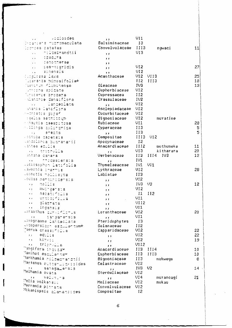
1
1
1
. ~ : = - : = = = - .::.::: 2
,~·-::,-,= ::::-:.::.a-
- '--:~·:·=:: = =::=:
:·:.:·_·.:.,;: ::=:--:-:-,::::. --~:--,·:.:.:..:.?">: = =-=--=--.::-:.: _:;-.~.-=-.a :::.:: ___ ;::.
' ' .... - : -=-= =: ~'- =: s
_.,."~=ï:ütis. -:::.:..:.:. =:.~=
•• L;~·::.:.:.::..:_ __
'• :r:~-::-:::::.:: - ~, ;· ~;1 t :-iu s .:. ..: -: _ : .: .:. : ..,.. _ =-
. . : ::- =-=-- =- =: s -:·xo9ra1nm.-= .:..=._- :.-=-:.:.::~
_·.-·::oper:=.i ..::: -- == =.._.:...:--- -::Jm* ·-·~-=-rud er.~:::.::.:..:.::
, " ed·_::..:: •1 ki~--~·:.:.
•.1 tr::-~,.:...:..:
2~1i::1fera :-:.::.? ":arr i hot es..:::..:.::--:~ "larkhamia :-~ - --=--~.:=.-- --~ ~ ."~:::.~.>t,__ .... 1'-= ..... ·------ -- ----
11:.i_ 1.._::;.- __ ::.-..:::ces
'' ~elhania 'J y-=. ~ . - - :=.
:'elia volk:::::_-~ -~~rre~ia p~:-.~~~=-, .1 kan l op sis -=..:..~-=-:::=-es
' ' Balsiminaceae Convolvulaceae
' ' ' ' ' ' '' ' ' Acanthaceae
Oleaceae Euphorbiaceae Cupressacea Crassulaceae
' ' Asclepiadaceae Cucurbitaceae Bignoniaceae Rubiaceae Cyperaceae
' ' Compositae Apocynaceae Anae:ardiaceae
' ' Verbenaceae
" Thymelaeaceae Lythraceae Labiatae
' ' ' ' ' ' ' ' ' ' ' ' ' ' Loranthaceae
' ' Pteridophytes Solanaceae Cappar i daceae
' ' ' ' ' ' Anacardiaceae
Euphorbiaceae Bignoniaceae Celastraceae
' ' Sterculiaceae
'' Meliaceae Convolvulaceae Composi tae
6
Vll !3
Il l 3 Vl3
Vl2 VI2 VI2 II 2 IV3 VI2 II2 IV2 VI2 VI2 'JI2 VI2 Vll !!3 !!3 I II3 !2
!!12 VI3 Il 3 !Vl I'Jl Vl2 l I 3 \JI 2 IV3 VI2 Il
Vll VI 12 tJI 1 VI2 Vll
!3 !!2 Vl2 Vl2 VI2 Vll2 II3 l I 3 l!3 V!2 Ilv13 Vl2 Vl4 lv'I2 Vl2
!2
ngwaci
\!! ! 3 !!!3
rnuratine
Vl2
muthumeke ki thar ara
l l l 4 l'J3
Vll
\!3
ll2
Il l 4 Ill3
mukwe90
V2
mur ancagi mukau
11
27
25 10 13
28 5 5
11 20 12
28
12
20
22 22 19
10 10
8
14
21

Millet t ia du ra Papilionaceae Momordica foetida Cucurbitaceae Monechma debile Acanthaceae 1 • ..JI 3 "rougarobanyoni 11 12 1 "muganj uk i 11 12 1 Mu sa sp*. Musac:eae I!3 I ll3 nrou tugat i Il 12 4 Myosotis vestergrenii Boraginaceae IV2 16 Myr i ,an thus holstii Morac:eae 12 mutuya 4 Myso-oxylon aethiopicum Celastraceae Neoboutonia macrocalyx Euphorbiacea.; 13 mutuntuki 3 Newtonia buchananii Mimosaceae 11 I 13 mukui 4 Nicotiana t abac:urn* Sol an ac:eae II 13 11 Nuxia congesta Loganiacea I1 mwangati Nymphaea caerulea Nympheaceae 1 I1
11 Ochna holstii Ochnaceae 13 mungarima
" ovata ' ' VI2 VI 13 muruti 251
Oei mum basilicum Labiatae IV4 Vl5 191
" lamiifolium ' ' IV2
61 " suave ' ' 113 1113 mukandu
' ' sp. ' ' 13 1
Ocotea usambarensi s Lauraceae I3 camp hor 21 Odontella fischeri Loranthaceae Vl2 (=Loranthus f.)
Oldenlandia herbacea Rubiaceae I!2 Olea hochstetteri Oleaceae 13 rï1ushar ag i 2 Op il ia campestris Opiliaceae Vl2 Oplismenis hirtellus Gramineae 13 Orni thogalum donaldson i i Lil i aceae Vil Oxalis latifolia Oxalidaceae I 13 5 Oxygonum sinuaturr1 Polygonaceae Il 4 ntaugu 9 Ozoroa insignis Anac:ardiac:eae II 2 mura 11 Pachycarpus schweinfurthi i Ascl epi adaceae !~)1 13 Paederia pospi schili i Rubiaceae lJJ 3 20 Pandanus erobuensi s Palr11ae VI1 Passiflora edul is* Passifloraceae !Il Pauridiantha holstii Rubi aceae !3 Pavetta tu tana Rubi aceae Pavonia ellenbecki i Malvaceae
' ' zeylanica ' '
l,)J 2 20 Pellaea longipilosa Pter i dophy te:. VI 12 30 Pennisetum clandestinum Grdmineae I!4 5
' ' purpureum ' ' I 14 9
' ' typhoides* ' ' VI4 (millet) 27
Pen tanasi a ouranogyne Rubiaceae Vl2 24 Pen tas lanceolata ' ' 113 6
' ' parvifolia '' IV3 14
PeperorÏfi a abyssinica Pteridoph~1tes 12 Phaseol is vulgaris* Papilionaceae l 14 10 Phoenix reel i nata Palmae VI1 Phyllan thus fischeri Euphorbiaceae 114 9
' ' roaderaE.patensi s ' ' VI3 19 Pilea johnstonii Urticaceae 12
' ' rivularis ' ' 12
Piliostigma thonni ngi i Caes.al pin i aceae 1113 lV3 V3 mukurah 15 Pinus elliotii* Pi r1ac:eae ll2
7

1 ' ' patula*
'' 112
1 " radiata*
' ' 112 Pi per c:apense Piperae:eae 15 Platye:er i urn angolense Pter i dophy tes 12 Plectranthus luteus Labiatae 12
1 " sylvestris
'' 13 Pleopel t is macroe:arpa Pteridophytes 13 Pleurostylia af r i cana Celastraceae
1 Plumbago zeylan i i Plumbaginaceae Vl2 23 Plumi era acutifolia Euphorbi aceae 111 Podoe:arpus mil anj i anus Podocarpaceae 13 po do 1
1 Polygala erioptera Polygalaceae IV2
' ' kilimandscharika ' '
Vil
" lini iflc<ra ' ' ' ' persicariifolia
' ' VI2 19
1 ' ' sadebee:k i an a ' ' VI2 19
Polyscias kikuyuensis Araliaceae !2 rriu cher ae:her o 4 Premna hildebrandti i Verbenaceae VI 12
1 ' ' oligotricha ' ' VJ2 VI 13 25
' ' resinosa ' ' VJ2
Pri va cordifolia Verbenae:eae VI2
1 Prunus africana Rosac:eae !2 rnuer ia 4 Pseudarthria hookeri Papilionaceae VI2 Pteridium aqu il i nurr1 Pteridophytes 12 !13 5 Pup alia lappacea Arnar an thaceae VJ4 19
1 Raphia ruffia Palmae 11 Rauvolfia mannii Apocynae:eae 13 Rhi n acanthus graci lis Ae:anthac:eae \.!13 VI 13 25
1 Rhus natalensis Anac:ardiae:eae IV1
' ' longi pes ' ' !Vl
Rhynchelytrum repens Gr ami neae Il3 1113 JV3 VI 2 12
1 Rhynchosia densiflora Papilionac:eae ')12
' ' malacophylla '' IV2
'' nyasic:a
'' IV3 14
' ' sublobata ' ' VJ2
1 " ~.p.
' ' '"..'I 2 Ri chardi a braziliensis Rubiaceae 1I3 5 Ri ei nus cornmun is Euphorbiaceae II3 II 12 9
1 Ruell ia patula Acanthac:eae l.JI 3 22 Salvadora persic:a Salvadorac:eae 1'\-112 Salvia e:oc:ci nea Labiatae Il3
1 Sanic:ula elata Umbelli ferae 12 Sansevieria ehrenbergi Lil i aceae Vl2 Schefflera volkensii Araliac:eae 13 Se:leroc:arya birrea Anacardiaceae VI2 'v'I I 2 mucomothi 25
1 Scutia myrtina Rhamnaceae 11 Securinega buc:hanan i E•Jphorbi aceae Vl3 21
'' vireisa
' ' VJ3 21
1 Senee:io discifolius Corr1posi tae 113 J II 4 10 Sesamothamnus rivae Pedaliaceae VI2 20 Sesbania quadrata Papilionaceae VI2
1 ' ' sesban ' ' ',)I 2
Si da cuneifolia Malvaceae 1!3 5
'' ovata
'' IV3 Vl3 10
Sigesbeckia ori en tal is Compositae 113 9
1 8
'

Solanuro incanuro Solanaceae 1!2 1113 Vl4 19
' ' n i grum
' ' 1!3 9
' ' tuberosum* ' '
113 9·,
Sonchus oler ae:eus Compositae !13 1II3 Vl2 10' Sorghurn vul gare* Gramineae 1113 . Vl4 27 Spathodea campanulata* Bignoniaceae II 3 8 Sperrnacoe:e pr i ncei Rubiaceae II 3 5
' ' senensis
' ' V!4 19
' ' sphaeros t i gma ' ' \)13 19
Sphaeranthus sp. Corr1posi tae Vl2 28 Sporob1Jlus f imbr i tus Gramineae 1JI3 19 Sterculia rhynchocarpa Sterculiaceae Vl2 n1ur ia 23 Streptocarpus montanus Gesneriae:eae 12 Strombosia scheff leri Olacaceae 14 n1userin9u 3 Strychnos madagascariensis Loganiaceae Vl Stylosanthes fru t i co sa Papilionaceae V!3 Suregada procera Euphobiaceae 12 rieme 1 Syzygium gu ineen se Myrtaceae 12 4 Tagetes minuta Compositae 114 rr1uvangi 6 Talinum portul·aci f ol i urn Portulacaceae Vl2 20 Taroarindus indica Caesalpiniaceae Vl2 muthithi Tabernaernontana holsti i Apocynaceae 13 mwerere 2 Tabernaemon tana johnstonii Apocynaceae 112 rnwerere Tapinanthus oehleri Lo1·anthaceae Vlll 30 Tarenna graveolens Rubiaceae Tephrosia elata Papilionaceae Vl2
' ' hildebrandti i ' ' 112 5
' ' polyphylla ''
Vl3 18
" pumi la ' ~ \!I 3 18
'' uniflora ' ' \JI 3 18
' ' v i llosa ' ' Vl3 18
Terminal ia brown i i Corobretaceae Vl3 VI 12 muhutu 16+24
' ' orbic:ularis ' ' Vl2
" prunioides
'' Vl4 n1u thun t i 24
' ' sp i no sa ' ' l.JI 2 Tetrapogon c:enchr i i f orroi s Grami neae Vl4 Themeda tri andr a Gr arïii neae IVl 17 Thunbergia alata Acanthaceae 113
1 ' ' garckeana ' ' Vll Tinospora caffra Men i spermaceae Vl2
1 Tithonia diversifolia Con1posi tae 114 kirurite 9
1 Tragia brev i pes Urt icaceae VI3 Tragus berteronianus Grarnineae Vl3 22 Tribulus terres tri s Zygophyllaceae lJJ 3 Trichilia roka Meliaceae 11 ll2 mururi 8
1 Tri chodesma zeylan i cum Boraginaceae l 12 l l l 3 10 Tri e:hornanes ri1elano tri e:hum Pteridophytes 12 Tridax pro e:urr1ben s Compositae 114 1113 IV3 12
1 Trifolium semi pi losufi1 Papilionaceae Triumphetta f l av esc:en s Tiliaceae Vl4 19
" macroph)•lla ' ' Il II2
1 ' ' rhomboidea ' ' l 14 l ll2 muri ndangurue 6 USP 1 Gr arrdneae IV 3 LISP ,,
IV1 17 ~ ' ' USP 3 ? IVl 17
l 9
1

1
J
1
IJSP 4 US? ~
..;
USP 6 USP 7 USP 8 USP 9 USP 10 USP 11 Van9ueria madagascariensis '.Jernoni a aemulans
'' '' ' ' '' '' :._.ii gna
")i tex
'.
auriculifera brachycalyx cinerascens lasiopus stenolepis
unguiculata* au reus* keniensis pay os strickeri
~~al:heria indica ~;~alos monospora :a~:hoxylum chalybeum
. , rnacrophyllurn ::--~ :"?iays* ::~~:a apiculata
Gr ami neae
'' Malvaceae Labiatae
? Gramineae
? Papilionaceae Rubiaceae Compositae
' ' ' ' ' ' ' ' ' ' Papilionaceae
'' Verbenaceae
' ' ' ' Sterculiaceae
Monimiaceae Rutaceae
' ' Gr an-1i neae Papilionaceae
10
Vl3 19 Vl3 19 Vl2 Vl2 Vl2 Vl2 VJ 12 30 VI 12 301
mupilu IV4 12 1!2 1 Vl
61 V2
l 13 muthatha Vll
1 l 1 l 4 thoroko 41 VI 3
12 IV3 mufru tri 13 !Vl IV4 VI3 12 !4 · mur i ndi 3
Vl 1 (=Fagara ch.) !2 4
l 14 l 115 (mai ze) 10 IV2 !3 19
~-----------____J____

Appendix I'J 1
AG?IC0T?ëRE U?-TIVE'RSI.,,-! (:~:t.GF"TT\\GE'r ,..,::-? ~,:E"'?-=-RI ~ -,~,..,..:g) - - - -- - -- - - . --- -- " ..... 1
RETY'JF? DA "f_l\ 5;.::sET DATF: NR: 1 VEG:STATION" DATA
1
\& . van Oostveen: D Scho He 1 • . rea.] ..1.. Strata 20 4C 60 8C ; O':' f·Xt. ;::;o f ig
'==·ho to: Run: ALTITl'.DE (~\ ' 32 64 1 Area:
~}apshe;t: 1 ,/" . _--.., c:.
1 -C .
Coordinates: 8-16 1
4 '-8 -.
1 1 DESCPIPTION OF SITE ""
L\l''f~)CSE m .
2-4 m 1 1
1-2 m 1
50cm-l . .
1 . 25-50
1
12-?.5 1 1
3-12 1
0-3 1
1
.
?.EIEVE? AREA: 'SPOT 'AREA: 0 i . ' PROV.VEG.UNIT iABORATORYI DATA -
TFRRAIN DATA 1
-}eological: 1 1 1
'ithology: SOII DPAINAGF ' 1
randform: 0 very poorly 0 poorly
b ?EI IÉF TYPE: 0 imperfectly almost flat(0-2) .:; hilly ( 16-30 \ 0 moderately well
RE(·~-t..RKS
r u:odulating ( 2-8' steeply 0 somewhat
0 excessively rolling ( 8-16) dissected (7301 0 excessively
Slope Exposition Soil type
1:.'icro 2.:r'~es.ore lief ' ' : "'°'0~ ION -1 - ".., - SUPFACF SEALING SOII. !·/ ft.P U~iIT ' ' 1
' ' 1 1
iëor. Depth(cm) ~onsistence 1 Ph Texture Dry colour Eoist colour ~/ottling P:C:l.-'- ' ,_
1
1 1
1 1
i 1
i
1 1 1
' 1
1
-. - - ·-
FINAL VEGETATION CT A.SSIFI CAT IN! 1 FINAI HAP mrrT

. ' 3 ' ···· 0 E
l ~T.KENYA
1 1.1
1
1
1
1
1.2
FOREST
1 1 1.1
2.1
1 . _.,,,..,. ... _... .
1
1
1
1
1
- . - . -
\ 1 =:::::::=:~~
1
~..#'
- ' 1
'~ \ _, -, _l _ -~ I~
2.2 0
/
2.2
&~~== .. ~3.1 0
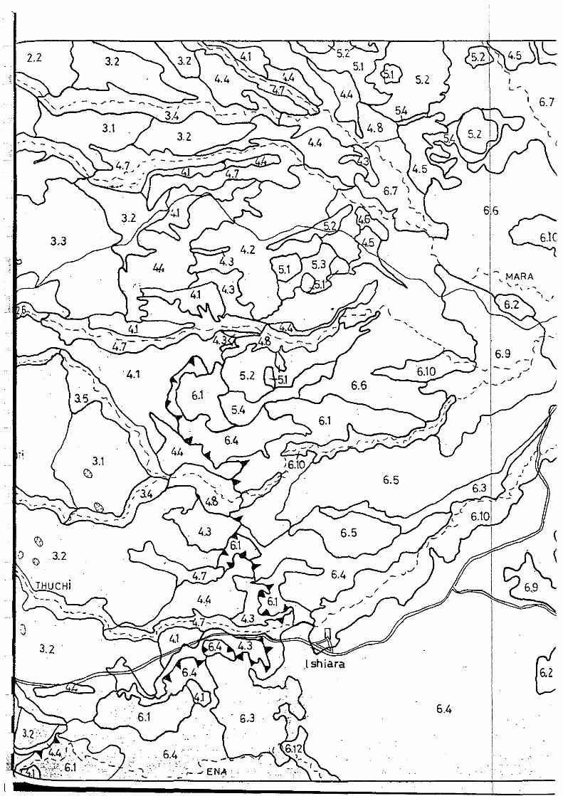
2.2
3.3
\0 -'.) 0 3.2
3.2
3.1 EJ
6.4
6.4 . -. - \---
~- • ·;.... J ENA •. - ..
"' ~ ~, MARA ~-~- ,_
" " l (
"'1-' •', ' '
1 1 . r ~ ~
1
6.9 < - r -1
~ - --'
'-1 /...r /
-- ;-' 1-1
(
<

:.7
l
<." \
6.~
Chiokarigc
.MUTONG.o(>.
6.5
. s.4!
KIJEGE FOREST
7.1
6.4
7.2
' 1
6.3
, 1
1
0°115' s
1 1 .
. ·. 1 ·
i . . ·o ·-1,--- ·, o ~o s ., .
. -·· .