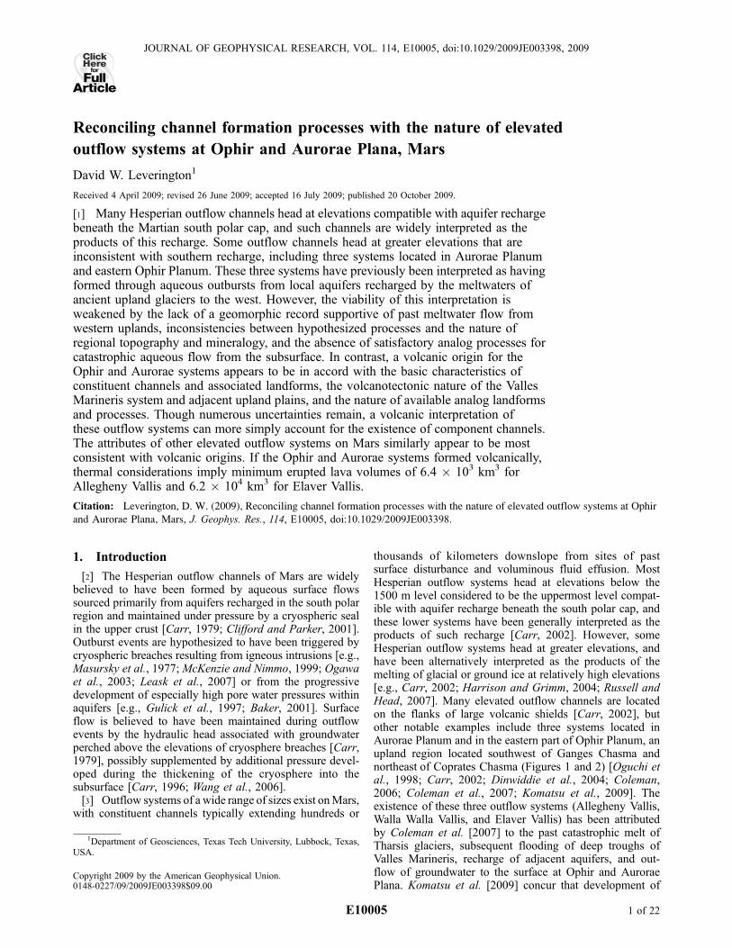
Embed Size (px)
Citation preview
Reconciling channel formation processes with the nature of elevated
outflow systems at Ophir and Aurorae Plana, Mars
David W. Leverington1
Received 4 April 2009; revised 26 June 2009; accepted 16 July 2009; published 20 October 2009.
[1] Many Hesperian outflow channels head at elevations compatible with aquifer rechargebeneath the Martian south polar cap, and such channels are widely interpreted as theproducts of this recharge. Some outflow channels head at greater elevations that areinconsistent with southern recharge, including three systems located in Aurorae Planumand eastern Ophir Planum. These three systems have previously been interpreted as havingformed through aqueous outbursts from local aquifers recharged by the meltwaters ofancient upland glaciers to the west. However, the viability of this interpretation isweakened by the lack of a geomorphic record supportive of past meltwater flow fromwestern uplands, inconsistencies between hypothesized processes and the nature ofregional topography and mineralogy, and the absence of satisfactory analog processes forcatastrophic aqueous flow from the subsurface. In contrast, a volcanic origin for theOphir and Aurorae systems appears to be in accord with the basic characteristics ofconstituent channels and associated landforms, the volcanotectonic nature of the VallesMarineris system and adjacent upland plains, and the nature of available analog landformsand processes. Though numerous uncertainties remain, a volcanic interpretation ofthese outflow systems can more simply account for the existence of component channels.The attributes of other elevated outflow systems on Mars similarly appear to be mostconsistent with volcanic origins. If the Ophir and Aurorae systems formed volcanically,thermal considerations imply minimum erupted lava volumes of 6.4 � 103 km3 forAllegheny Vallis and 6.2 � 104 km3 for Elaver Vallis.
Citation: Leverington, D. W. (2009), Reconciling channel formation processes with the nature of elevated outflow systems at Ophir
and Aurorae Plana, Mars, J. Geophys. Res., 114, E10005, doi:10.1029/2009JE003398.
1. Introduction
[2] The Hesperian outflow channels of Mars are widelybelieved to have been formed by aqueous surface flowssourced primarily from aquifers recharged in the south polarregion and maintained under pressure by a cryospheric sealin the upper crust [Carr, 1979; Clifford and Parker, 2001].Outburst events are hypothesized to have been triggered bycryospheric breaches resulting from igneous intrusions [e.g.,Masursky et al., 1977; McKenzie and Nimmo, 1999; Ogawaet al., 2003; Leask et al., 2007] or from the progressivedevelopment of especially high pore water pressures withinaquifers [e.g., Gulick et al., 1997; Baker, 2001]. Surfaceflow is believed to have been maintained during outflowevents by the hydraulic head associated with groundwaterperched above the elevations of cryosphere breaches [Carr,1979], possibly supplemented by additional pressure devel-oped during the thickening of the cryosphere into thesubsurface [Carr, 1996; Wang et al., 2006].[3] Outflow systems of a wide range of sizes exist onMars,
with constituent channels typically extending hundreds or
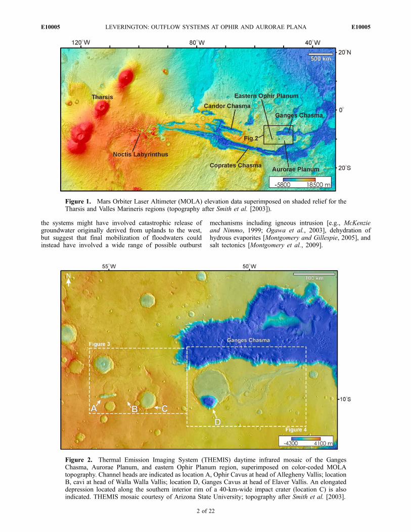
thousands of kilometers downslope from sites of pastsurface disturbance and voluminous fluid effusion. MostHesperian outflow systems head at elevations below the1500 m level considered to be the uppermost level compat-ible with aquifer recharge beneath the south polar cap, andthese lower systems have been generally interpreted as theproducts of such recharge [Carr, 2002]. However, someHesperian outflow systems head at greater elevations, andhave been alternatively interpreted as the products of themelting of glacial or ground ice at relatively high elevations[e.g., Carr, 2002; Harrison and Grimm, 2004; Russell andHead, 2007]. Many elevated outflow channels are locatedon the flanks of large volcanic shields [Carr, 2002], butother notable examples include three systems located inAurorae Planum and in the eastern part of Ophir Planum, anupland region located southwest of Ganges Chasma andnortheast of Coprates Chasma (Figures 1 and 2) [Oguchi etal., 1998; Carr, 2002; Dinwiddie et al., 2004; Coleman,2006; Coleman et al., 2007; Komatsu et al., 2009]. Theexistence of these three outflow systems (Allegheny Vallis,Walla Walla Vallis, and Elaver Vallis) has been attributedby Coleman et al. [2007] to the past catastrophic melt ofTharsis glaciers, subsequent flooding of deep troughs ofValles Marineris, recharge of adjacent aquifers, and out-flow of groundwater to the surface at Ophir and AuroraePlana. Komatsu et al. [2009] concur that development of
JOURNAL OF GEOPHYSICAL RESEARCH, VOL. 114, E10005, doi:10.1029/2009JE003398, 2009ClickHere
for
FullArticle
1Department of Geosciences, Texas Tech University, Lubbock, Texas,USA.
Copyright 2009 by the American Geophysical Union.0148-0227/09/2009JE003398$09.00
E10005 1 of 22
the systems might have involved catastrophic release ofgroundwater originally derived from uplands to the west,but suggest that final mobilization of floodwaters couldinstead have involved a wide range of possible outburst
mechanisms including igneous intrusion [e.g., McKenzieand Nimmo, 1999; Ogawa et al., 2003], dehydration ofhydrous evaporites [Montgomery and Gillespie, 2005], andsalt tectonics [Montgomery et al., 2009].
Figure 1. Mars Orbiter Laser Altimeter (MOLA) elevation data superimposed on shaded relief for theTharsis and Valles Marineris regions (topography after Smith et al. [2003]).
Figure 2. Thermal Emission Imaging System (THEMIS) daytime infrared mosaic of the GangesChasma, Aurorae Planum, and eastern Ophir Planum region, superimposed on color-coded MOLAtopography. Channel heads are indicated as location A, Ophir Cavus at head of Allegheny Vallis; locationB, cavi at head of Walla Walla Vallis; location D, Ganges Cavus at head of Elaver Vallis. An elongateddepression located along the southern interior rim of a 40-km-wide impact crater (location C) is alsoindicated. THEMIS mosaic courtesy of Arizona State University; topography after Smith et al. [2003].
E10005 LEVERINGTON: OUTFLOW SYSTEMS AT OPHIR AND AURORAE PLANA
2 of 22
E10005
[4] Although a catastrophic aqueous origin for the chan-nels of Ophir and Aurorae Plana would be consistent withpast interpretations of other outflow systems on Mars [e.g.,Mars Channel Working Group, 1983], key aspects of theaqueous model of Coleman et al. [2007] do not appear to beconsistent with the basic nature of these channels, theadjacent Valles Marineris canyon system, and the uplandsthat comprise the Tharsis region. In this paper, possibledifficulties with aqueous interpretations of the Ophir andAurorae systems are identified, and the origin of thesesystems is reconsidered on the basis of the congruencebetween channel characteristics and those expected ofvolcanic landforms. The potential of volcanic processes tomore generally account for the existence of other elevatedHesperian outflow systems is outlined.
2. Basic Characteristics of the Outflow Channelsof Ophir and Aurorae Plana
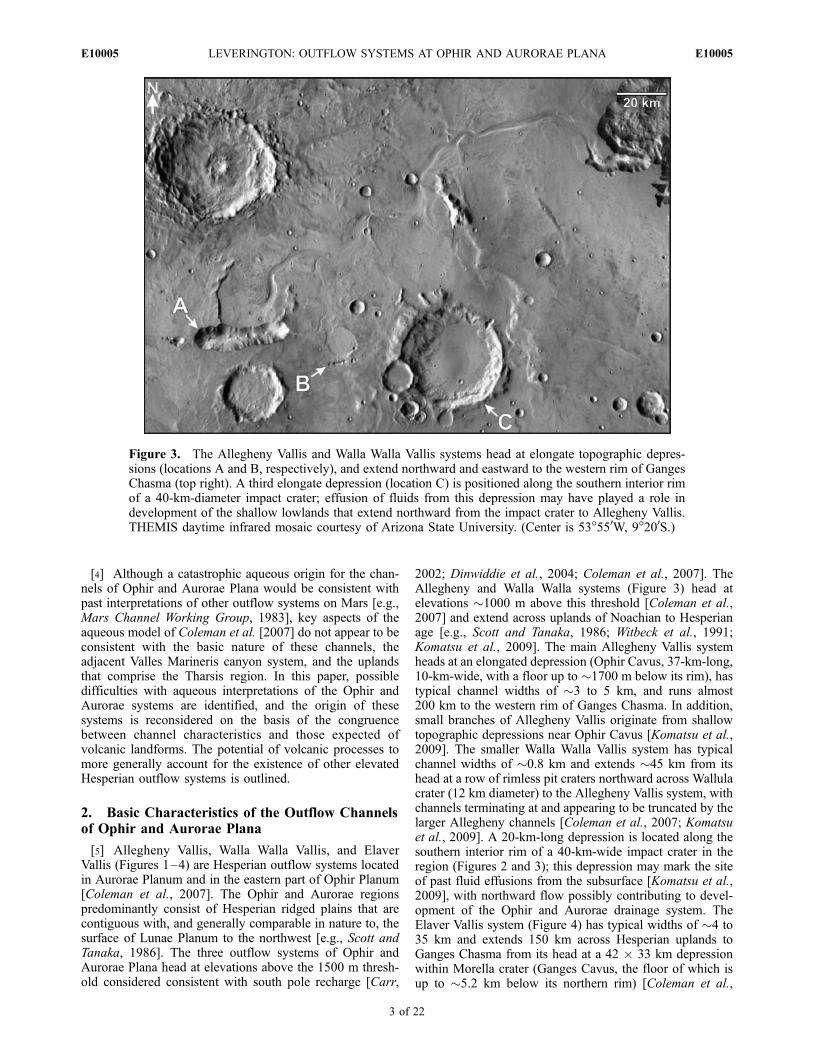
[5] Allegheny Vallis, Walla Walla Vallis, and ElaverVallis (Figures 1–4) are Hesperian outflow systems locatedin Aurorae Planum and in the eastern part of Ophir Planum[Coleman et al., 2007]. The Ophir and Aurorae regionspredominantly consist of Hesperian ridged plains that arecontiguous with, and generally comparable in nature to, thesurface of Lunae Planum to the northwest [e.g., Scott andTanaka, 1986]. The three outflow systems of Ophir andAurorae Plana head at elevations above the 1500 m thresh-old considered consistent with south pole recharge [Carr,
2002; Dinwiddie et al., 2004; Coleman et al., 2007]. TheAllegheny and Walla Walla systems (Figure 3) head atelevations �1000 m above this threshold [Coleman et al.,2007] and extend across uplands of Noachian to Hesperianage [e.g., Scott and Tanaka, 1986; Witbeck et al., 1991;Komatsu et al., 2009]. The main Allegheny Vallis systemheads at an elongated depression (Ophir Cavus, 37-km-long,10-km-wide, with a floor up to �1700 m below its rim), hastypical channel widths of �3 to 5 km, and runs almost200 km to the western rim of Ganges Chasma. In addition,small branches of Allegheny Vallis originate from shallowtopographic depressions near Ophir Cavus [Komatsu et al.,2009]. The smaller Walla Walla Vallis system has typicalchannel widths of �0.8 km and extends �45 km from itshead at a row of rimless pit craters northward across Wallulacrater (12 km diameter) to the Allegheny Vallis system, withchannels terminating at and appearing to be truncated by thelarger Allegheny channels [Coleman et al., 2007; Komatsuet al., 2009]. A 20-km-long depression is located along thesouthern interior rim of a 40-km-wide impact crater in theregion (Figures 2 and 3); this depression may mark the siteof past fluid effusions from the subsurface [Komatsu et al.,2009], with northward flow possibly contributing to devel-opment of the Ophir and Aurorae drainage system. TheElaver Vallis system (Figure 4) has typical widths of �4 to35 km and extends 150 km across Hesperian uplands toGanges Chasma from its head at a 42 � 33 km depressionwithin Morella crater (Ganges Cavus, the floor of which isup to �5.2 km below its northern rim) [Coleman et al.,
Figure 3. The Allegheny Vallis and Walla Walla Vallis systems head at elongate topographic depres-sions (locations A and B, respectively), and extend northward and eastward to the western rim of GangesChasma (top right). A third elongate depression (location C) is positioned along the southern interior rimof a 40-km-diameter impact crater; effusion of fluids from this depression may have played a role indevelopment of the shallow lowlands that extend northward from the impact crater to Allegheny Vallis.THEMIS daytime infrared mosaic courtesy of Arizona State University. (Center is 53�550W, 9�200S.)
E10005 LEVERINGTON: OUTFLOW SYSTEMS AT OPHIR AND AURORAE PLANA
3 of 22
E10005
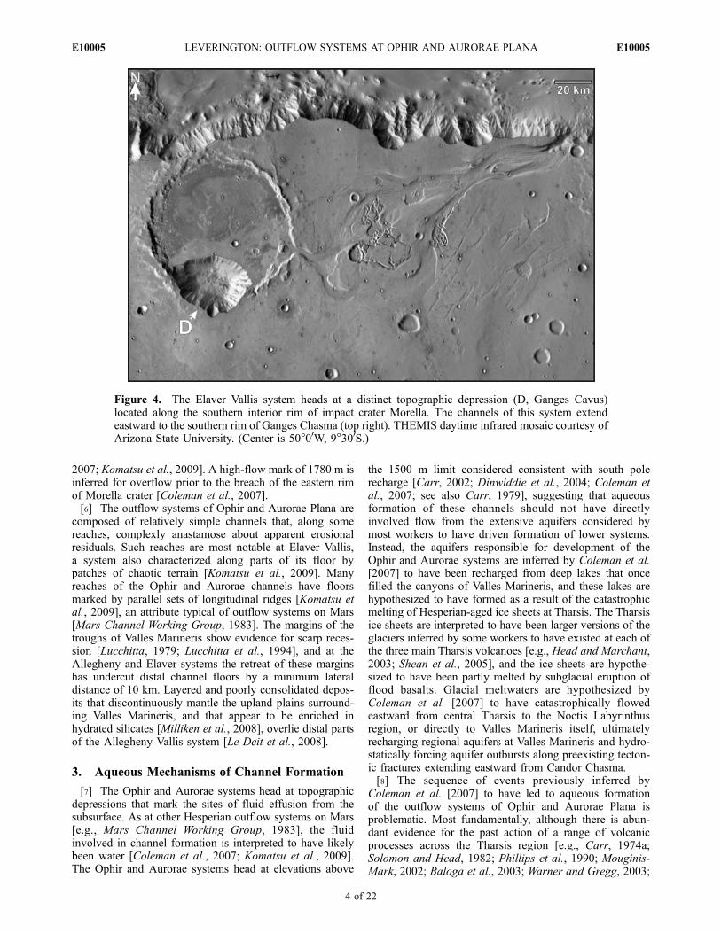
2007; Komatsu et al., 2009]. A high-flow mark of 1780 m isinferred for overflow prior to the breach of the eastern rimof Morella crater [Coleman et al., 2007].[6] The outflow systems of Ophir and Aurorae Plana are
composed of relatively simple channels that, along somereaches, complexly anastamose about apparent erosionalresiduals. Such reaches are most notable at Elaver Vallis,a system also characterized along parts of its floor bypatches of chaotic terrain [Komatsu et al., 2009]. Manyreaches of the Ophir and Aurorae channels have floorsmarked by parallel sets of longitudinal ridges [Komatsu etal., 2009], an attribute typical of outflow systems on Mars[Mars Channel Working Group, 1983]. The margins of thetroughs of Valles Marineris show evidence for scarp reces-sion [Lucchitta, 1979; Lucchitta et al., 1994], and at theAllegheny and Elaver systems the retreat of these marginshas undercut distal channel floors by a minimum lateraldistance of 10 km. Layered and poorly consolidated depos-its that discontinuously mantle the upland plains surround-ing Valles Marineris, and that appear to be enriched inhydrated silicates [Milliken et al., 2008], overlie distal partsof the Allegheny Vallis system [Le Deit et al., 2008].
3. Aqueous Mechanisms of Channel Formation
[7] The Ophir and Aurorae systems head at topographicdepressions that mark the sites of fluid effusion from thesubsurface. As at other Hesperian outflow systems on Mars[e.g., Mars Channel Working Group, 1983], the fluidinvolved in channel formation is interpreted to have likelybeen water [Coleman et al., 2007; Komatsu et al., 2009].The Ophir and Aurorae systems head at elevations above
the 1500 m limit considered consistent with south polerecharge [Carr, 2002; Dinwiddie et al., 2004; Coleman etal., 2007; see also Carr, 1979], suggesting that aqueousformation of these channels should not have directlyinvolved flow from the extensive aquifers considered bymost workers to have driven formation of lower systems.Instead, the aquifers responsible for development of theOphir and Aurorae systems are inferred by Coleman et al.[2007] to have been recharged from deep lakes that oncefilled the canyons of Valles Marineris, and these lakes arehypothesized to have formed as a result of the catastrophicmelting of Hesperian-aged ice sheets at Tharsis. The Tharsisice sheets are interpreted to have been larger versions of theglaciers inferred by some workers to have existed at each ofthe three main Tharsis volcanoes [e.g., Head and Marchant,2003; Shean et al., 2005], and the ice sheets are hypothe-sized to have been partly melted by subglacial eruption offlood basalts. Glacial meltwaters are hypothesized byColeman et al. [2007] to have catastrophically flowedeastward from central Tharsis to the Noctis Labyrinthusregion, or directly to Valles Marineris itself, ultimatelyrecharging regional aquifers at Valles Marineris and hydro-statically forcing aquifer outbursts along preexisting tecton-ic fractures extending eastward from Candor Chasma.[8] The sequence of events previously inferred by
Coleman et al. [2007] to have led to aqueous formationof the outflow systems of Ophir and Aurorae Plana isproblematic. Most fundamentally, although there is abun-dant evidence for the past action of a range of volcanicprocesses across the Tharsis region [e.g., Carr, 1974a;Solomon and Head, 1982; Phillips et al., 1990; Mouginis-Mark, 2002; Baloga et al., 2003; Warner and Gregg, 2003;
Figure 4. The Elaver Vallis system heads at a distinct topographic depression (D, Ganges Cavus)located along the southern interior rim of impact crater Morella. The channels of this system extendeastward to the southern rim of Ganges Chasma (top right). THEMIS daytime infrared mosaic courtesy ofArizona State University. (Center is 50�00W, 9�300S.)
E10005 LEVERINGTON: OUTFLOW SYSTEMS AT OPHIR AND AURORAE PLANA
4 of 22
E10005
Mouginis-Mark and Christensen, 2005; Bleacher et al.,2007a; Hiesinger et al., 2007; Baptista et al., 2008;Mangold et al., 2008a; Plescia and Baloga, 2008; Tysonet al., 2008], the geomorphic evidence for the past existenceof large Tharsis glaciers is equivocal [e.g., Mouginis-Markand Rowland, 2008], and there is no geomorphic recordsupportive of the hypothesized catastrophic flow of Hespe-rian meltwaters from Tharsis to Noctis Labyrithus orValles Marineris. The volume of modern Valles Marinerisis �3.6 � 106 km3 [Lucchitta et al., 1994], and thevolume of void space available for ancient aquifers at eastTharsis is estimated to have exceeded 1 � 107 km3 [Dohmet al., 2001]. The water volumes involved in aqueousscenarios may thus be comparable to the 5 � 106 km3
minimum estimate for total known water volume at highand middle latitudes today [Christensen, 2006], and the 3 �106 km3 minimum total volume estimated to have beenrequired to form the circum-Chryse outflow systems[Harrison and Grimm, 2004]. To be consistent with pre-sumed mechanisms of formation of the outflow channels
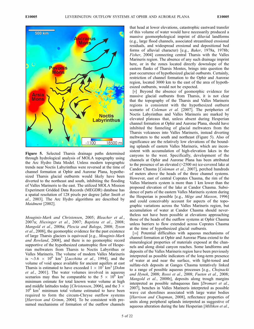
that head at lower elevations, catastrophic eastward transferof this volume of water would have necessarily produced amassive geomorphological imprint of diluvial landforms(e.g., large flood channels, associated streamlined erosionalresiduals, and widespread erosional and depositional bedforms of alluvial character) [e.g., Baker, 1978a, 1978b;Fisher, 2004] connecting central Tharsis with the VallesMarineris region. The absence of any such drainage imprinthere, or in the zones located directly downslope of theeastern flanks of Tharsis Montes, brings into question thepast occurrence of hypothesized glacial outbursts. Certainly,restriction of channel formation to the Ophir and Auroraeregion, located 3000 km to the east of the area of hypoth-esized outbursts, would not be expected.[9] Beyond the absence of geomorphic evidence for
massive glacial outbursts from Tharsis, it is not clearthat the topography of the Tharsis and Valles Marinerisregions is consistent with the hypothesized outburstscenario of Coleman et al. [2007]. The peripheries ofNoctis Labyrinthus and Valles Marineris are marked byelevated plateaus that, unless absent during Hesperianchannel formation at Ophir and Aurorae Plana, should haveinhibited the funneling of glacial meltwaters from theTharsis volcanoes into Valles Marineris, instead divertingmeltwaters to the south and northeast (Figure 5). Also ofsignificance are the relatively low elevations of the bound-ing uplands of eastern Valles Marineris, which are incon-sistent with accumulation of high-elevation lakes in thecanyons to the west. Specifically, development of thechannels at Ophir and Aurorae Plana has been attributedto the presence of an elevated (>2500 m) ice-covered lake atCandor Chasma [Coleman et al., 2007], perched hundredsof meters above the heads of the three channel systems.However, east of central Coprates Chasma, the rim of theValles Marineris system is more than 1 km lower than theproposed elevation of the lake at Candor Chasma. Subsi-dence of parts of the eastern Valles Marineris system duringthe Hesperian is possible [e.g., Mege and Masson, 1996]and could conceivably account for aspects of the topo-graphic variations across the Valles Marineris region, butaccumulation of water at Candor Chasma should never-theless not have been possible at elevations approachingthose of the heads of the outflow systems at Ophir Chasmaunless barriers to flow extended across Coprates Chasmaat the time of hypothesized glacial outbursts.[10] Potential difficulties with aqueous mechanisms of
channel formation at Ophir and Aurorae Plana extend to themineralogical properties of materials exposed at the chan-nels and along distal canyon reaches. Some landforms anddeposits of the Valles Marineris region have been previouslyinterpreted as possible indicators of the long-term presenceof water at and near the surface, with light-toned andsulfate-rich deposits at Ganges Chasma tentatively linkedto a range of possible aqueous processes [e.g., Chojnackiand Hynek, 2008; Rossi et al., 2008; Fueten et al., 2008;Mangold et al., 2008b], deposits along trough marginsinterpreted as possible subaqueous fans [Dromart et al.,2007], benches in Valles Marineris interpreted as possiblewave cut shorelines associated with large water bodies[Harrison and Chapman, 2008], reflectance properties ofunits along peripheral uplands interpreted as suggestive ofaqueous alteration during the late Hesperian [Milliken et al.,
Figure 5. Selected Tharsis drainage paths determinedthrough hydrological analysis of MOLA topography usingthe Arc Hydro Data Model. Unless modern topographictrends near Noctis Labyrinthus were reversed at the time ofchannel formation at Ophir and Aurorae Plana, hypothe-sized Tharsis glacial outbursts would likely have beendiverted to the northeast and south, inhibiting the floodingof Valles Marineris to the east. The utilized MOLA MissionExperiment Gridded Data Records (MEGDR) database hasa spatial resolution of 128 pixels per degree [after Smith etal., 2003]. The Arc Hydro algorithms are described byMaidment [2002].
E10005 LEVERINGTON: OUTFLOW SYSTEMS AT OPHIR AND AURORAE PLANA
5 of 22
E10005

2008], and deformation at Tharsis and Valles Marinerisinterpreted as consistent with the action of tectonic processesrelated to the presence of underlying salt deposits accumu-lated in Noachian drainage basins or aquifers [Montgomeryet al., 2009]. However, all three Ophir and Aurorae outflowsystems terminate at Ganges Chasma, a deep trough ofeastern Valles Marineris that, though partly mantled byunconsolidated materials, shows evidence for being flooredby flow units of basaltic composition and high thermalinertia [e.g., Mellon et al., 2000; Christensen et al., 2003;Edwards et al., 2008; Rossi et al., 2008]. A particular basaltunit near the floor of Ganges Chasma has been identified asolivine-rich on the basis of Thermal Emission Spectrometer(TES) hyperspectral data and Thermal Emission ImagingSystem (THEMIS) multispectral data [Christensen et al.,2003; Edwards et al., 2008] and is likely to be readilyaltered under aqueous conditions [e.g., Hausrath et al.,2008]. This olivine-rich unit forms a thick (�50 m) layerin the north and south walls of Ganges Chasma, withexposed outcrops appearing to be remnants of a oncecontinuous unit [Edwards et al., 2008], indicating thatemplacement of this unit likely substantially predatesdevelopment of the outflow systems of Ophir and AuroraePlana. In addition, olivine-rich units have been identified atMorella crater, which forms part of the head region of theElaver Vallis system, on the basis of analysis of TES data[Koeppen and Hamilton, 2008] and Observatoire pour laMineralogie, l’Eau, les Glaces et l’Activite (OMEGA)hyperspectral data [Komatsu et al., 2009]. Though uncer-tainties remain, the apparently pristine nature of the basaltunits exposed in the walls of Ganges Chasma is poten-tially incompatible with significant aqueous weathering[Christensen et al., 2003], and may not be easily recon-ciled with the past existence here of canyon-filling waterbodies, massive groundwater stores, and a water-saturatedcryospheric seal. Similarly, if the olivine-rich units near thehead of Elaver Vallis do not postdate development ofassociated channels, their presence may be incompatiblewith aqueous scenarios of channel growth involving thelonger-term presence of water at or near the surface[Komatsu et al., 2009].[11] The existence of an ice-rich cryospheric seal of
hemispheric or global extent is widely considered to havebeen necessary for pressurization and later discharge oflarge volumes of southern groundwater, processes presumedto have formed the most prominent Hesperian outflowsystems on Mars [e.g., Carr, 1979, 2002; Clifford, 1993;Rodriguez et al., 2005; Andrews-Hanna and Phillips, 2007;Leask et al., 2007; Harrison and Grimm, 2008]. Problem-atically, the deep infiltration of glacial floodwaters atTharsis and Valles Marineris hypothesized by Coleman etal. [2007] is inconsistent with the existence of such a seal.Coleman et al. [2007] acknowledge this difficulty, andsuggest that the pooling of water at Valles Marineris couldhave resulted in the thaw of a deep talik beneath canyonfloors, permitting local recharge of an underlying or adja-cent regional aquifer. However, this scenario remains incon-sistent with the absence of large channel systems linkingcentral Tharsis and Valles Marineris, and does not provide amechanism for corresponding thaw beneath the heads of theGanges Chasma systems. More fundamentally, it is unclearthat floodwaters would have had sufficient thermal energy
to flow several thousand kilometers across the Martiansurface, to pool at Valles Marineris, to thaw a thickcryospheric seal, and to deeply infiltrate before the watersthemselves became frozen (or were vaporized). Regardlessof the capacity of water to reach and pool at VallesMarineris, the thaw of a kilometers-thick ice-rich cryo-sphere at both Valles Marineris and at the sources of theOphir and Aurorae systems should not have taken place as acatastrophic event, since even magma-driven thawing of anice-rich Martian cryosphere has been estimated to require upto several million years for completion [e.g., McKenzie andNimmo, 1999; Ogawa et al., 2003], in part because the thawof any ice-rich body of permafrost is slowed by theabsorption of thermal energy related to the latent heat offusion of water [e.g., Williams and Smith, 1989].[12] Aqueous interpretations of the outflow systems of
Ophir and Aurorae Plana are based on the premise thatcatastrophic release of water from regional or hemisphericaquifers is a viable process that is likely to have operated inthis region and at the heads of numerous other outflowsystems on Mars. However, it is not clear that confidence inthis premise is warranted. Continued investigation intoproposed aqueous mechanisms of outflow channel forma-tion on Mars has served to highlight their many associatedlimitations. Perhaps most critically, the volumes and peakdischarge rates of hypothesized Martian floods remainunreconciled with the expected regional-scale permeabilitiesof even highly porous materials [e.g., Harrison and Grimm,2008]. Outburst models have been modified to reduce theimpact of these permeability issues through the propositionof widespread physical disruption of host aquifer materials[e.g., Carr, 1996], but these modified models neverthelessappear to be inconsistent with the sediment-water ratiosrequired for flow of disrupted materials to occur, and cannotaccount for the constraints on outflow rates imposed by thediffusion limits of intact aquifers surrounding disruptedzones [Andrews-Hanna and Phillips, 2007]. The hypothe-sized scenario of Coleman et al. [2007] for outflow channelformation at Ophir and Aurorae Plana is further complicatedby reliance upon the catastrophic nature of hypothesizedevents, with sudden outbursts from aquifers presumablypreceded by some form of catastrophic infiltration fromdeep Valles Marineris lakes to these aquifers.[13] Hypotheses for the existence of large cryosphere-
confined aquifers on ancient Mars were originally formu-lated as a means to account for the basic nature of outflowsystems on that planet [Carr, 1979], but, although efforts toidentify possible evidence for the past existence of largeMartian aquifers continue [e.g., Treiman, 2008; Mangold etal., 2008b], the past existence of such aquifers remainsuncertain [e.g., Russell and Head, 2002; Fassett and Head,2008]. Related hypotheses for the catastrophic aqueousdevelopment of Martian outflow systems continue to beweakened by the absence of satisfactory analog processesfor the sudden release of large volumes of water from thesubsurface. Although terrestrial landscapes such as theChanneled Scabland of Washington and the flood systemsof the Mongolian plateau have been cited as possibleanalogs to the terrain that characterizes outflow systemson Mars [e.g., Baker and Milton, 1974; Sharp and Malin,1975; Komatsu et al., 2004; Andrews-Hanna and Phillips,2007], including the channels of Ophir and Aurorae Plana
E10005 LEVERINGTON: OUTFLOW SYSTEMS AT OPHIR AND AURORAE PLANA
6 of 22
E10005
[Coleman et al., 2007], the mechanisms of formation ofterrestrial systems may offer little in the way of insight intothe root causes of outflow channel formation on Mars[Leverington, 2007]. Whereas outflow systems such asthose of Ophir and Aurorae Plana developed as a result ofvoluminous flow from the subsurface, the widely citedlandforms of the Channeled Scabland formed in responseto entirely different processes related to the release offloodwaters from an ice-dammed lake [e.g., Bretz et al.,1956; Baker, 1978a; Smith, 1993]. In the near term, sub-stantial progress in our understanding of Martian outflowsystems such as those of Ophir and Aurorae Plana maydepend upon identification of genuine analog processes tothose that initiated development of these systems.
4. A Volcanic Alternative to AqueousDevelopment of the Outflow Channels of Ophirand Aurorae Plana
[14] The difficulties associated with hypothesized aque-ous mechanisms of channel development at Ophir andAurorae Plana suggest that promising alternative processesshould be investigated. Although aeolian, glacial, and CO2-based processes of channel formation have been previouslyrejected for the Ophir and Aurorae systems [Coleman et al.,2007], volcanism [Cutts et al., 1978; Schonfeld, 1979;Leverington, 2004a, 2007] has not yet been closely exam-
ined as a possible mechanism for initiation and developmentof these systems. Significantly, a volcanic origin for thesesystems appears to be in accord with numerous basicconsiderations, including the volcanotectonic nature of theValles Marineris region, the likely development of much ofthe Ophir and Aurorae Plana region itself through extrusiveigneous processes, the consistency between properties oflocal channel deposits and those expected of volcanicmaterials, the correspondence between channel character-istics and those of volcanic analogs of the inner solarsystem, and the consistency between defining features ofthe Ophir and Aurorae Plana systems and recognizedvolcanic processes involving voluminous flow from thesubsurface.
4.1. Consistency of Channel Properties With VolcanicOrigins
[15] A volcanic origin for the outflow channels of Ophirand Aurorae Plana is consistent with the volcanotectonicnature of the Valles Marineris system. This system consistsof deep (�5 to 10 km) Hesperian-aged troughs that haveattributes congruous with formation by rift-like processesinvolving extension, normal faulting, and subsidence [e.g.,Plescia and Saunders, 1982; Lucchitta et al., 1992; Schultz,1995; Mege and Masson, 1996; Wilkins and Schultz, 2003;Borraccini et al., 2007]. Formation of the Valles Marinerissystem appears to have been at least partly related todevelopment of structural features oriented radially toTharsis [Carr, 1974a], a large volcanic province character-ized by an extended history (Noachian to Amazonian) ofigneous processes involving substantial crustal constructionand uplift [e.g., Carr, 1974a; Phillips et al., 1990; Okuboand Schultz, 2003; Williams et al., 2008; Jellinek et al.,2008]. Although mantling deposits of the interior of VallesMarineris consist in part of layered and partly erodedHesperian units of apparent sedimentary origin [e.g.,Komatsu et al., 1993a; Quantin et al., 2005; Fueten et al.,2008], as well as mass wasting deposits that have accumu-lated along trough flanks [e.g., McEwen, 1989; Lucchitta etal., 1994; Peulvast et al., 2001; Komatsu et al., 2009],exposed floor units consist at least partly of volcanic flows[e.g., Christensen et al., 2003] and the layered units ofcanyon walls have properties consistent with formationthrough extrusive and intrusive igneous processes [e.g.,Geissler et al., 1990; McEwen et al., 1999; Williams etal., 2003; Edwards et al., 2008].[16] Aurorae Planum and eastern Ophir Planum together
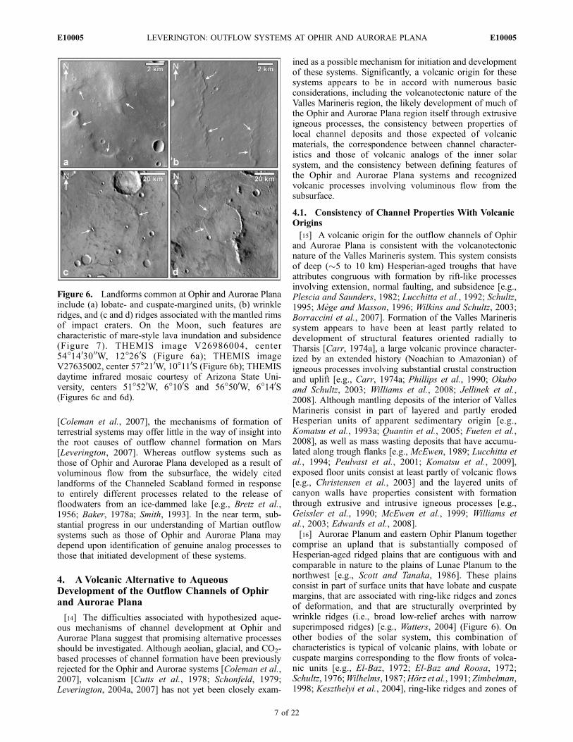
comprise an upland that is substantially composed ofHesperian-aged ridged plains that are contiguous with andcomparable in nature to the plains of Lunae Planum to thenorthwest [e.g., Scott and Tanaka, 1986]. These plainsconsist in part of surface units that have lobate and cuspatemargins, that are associated with ring-like ridges and zonesof deformation, and that are structurally overprinted bywrinkle ridges (i.e., broad low-relief arches with narrowsuperimposed ridges) [e.g., Watters, 2004] (Figure 6). Onother bodies of the solar system, this combination ofcharacteristics is typical of volcanic plains, with lobate orcuspate margins corresponding to the flow fronts of volca-nic units [e.g., El-Baz, 1972; El-Baz and Roosa, 1972;Schultz, 1976;Wilhelms, 1987;Horz et al., 1991; Zimbelman,1998; Keszthelyi et al., 2004], ring-like ridges and zones of
Figure 6. Landforms common at Ophir and Aurorae Planainclude (a) lobate- and cuspate-margined units, (b) wrinkleridges, and (c and d) ridges associated with the mantled rimsof impact craters. On the Moon, such features arecharacteristic of mare-style lava inundation and subsidence(Figure 7). THEMIS image V26986004, center54�1403000W, 12�260S (Figure 6a); THEMIS imageV27635002, center 57�210W, 10�110S (Figure 6b); THEMISdaytime infrared mosaic courtesy of Arizona State Uni-versity, centers 51�520W, 6�100S and 56�500W, 6�140S(Figures 6c and 6d).
E10005 LEVERINGTON: OUTFLOW SYSTEMS AT OPHIR AND AURORAE PLANA
7 of 22
E10005
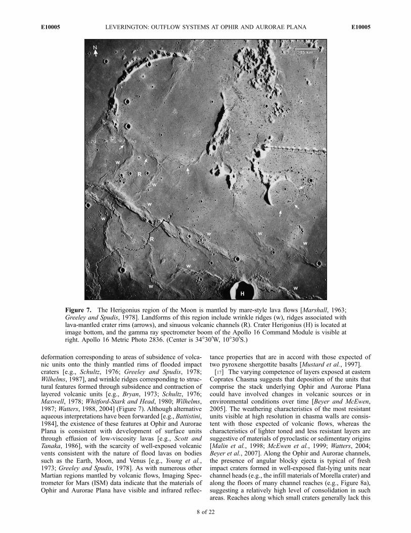
deformation corresponding to areas of subsidence of volca-nic units onto the thinly mantled rims of flooded impactcraters [e.g., Schultz, 1976; Greeley and Spudis, 1978;Wilhelms, 1987], and wrinkle ridges corresponding to struc-tural features formed through subsidence and contraction oflayered volcanic units [e.g., Bryan, 1973; Schultz, 1976;Maxwell, 1978; Whitford-Stark and Head, 1980; Wilhelms,1987; Watters, 1988, 2004] (Figure 7). Although alternativeaqueous interpretations have been forwarded [e.g., Battistini,1984], the existence of these features at Ophir and AuroraePlana is consistent with development of surface unitsthrough effusion of low-viscosity lavas [e.g., Scott andTanaka, 1986], with the scarcity of well-exposed volcanicvents consistent with the nature of flood lavas on bodiessuch as the Earth, Moon, and Venus [e.g., Young et al.,1973; Greeley and Spudis, 1978]. As with numerous otherMartian regions mantled by volcanic flows, Imaging Spec-trometer for Mars (ISM) data indicate that the materials ofOphir and Aurorae Plana have visible and infrared reflec-
tance properties that are in accord with those expected oftwo pyroxene shergottite basalts [Mustard et al., 1997].[17] The varying competence of layers exposed at eastern
Coprates Chasma suggests that deposition of the units thatcomprise the stack underlying Ophir and Aurorae Planacould have involved changes in volcanic sources or inenvironmental conditions over time [Beyer and McEwen,2005]. The weathering characteristics of the most resistantunits visible at high resolution in chasma walls are consis-tent with those expected of volcanic flows, whereas thecharacteristics of lighter toned and less resistant layers aresuggestive of materials of pyroclastic or sedimentary origins[Malin et al., 1998; McEwen et al., 1999; Watters, 2004;Beyer et al., 2007]. Along the Ophir and Aurorae channels,the presence of angular blocky ejecta is typical of freshimpact craters formed in well-exposed flat-lying units nearchannel heads (e.g., the infill materials of Morella crater) andalong the floors of many channel reaches (e.g., Figure 8a),suggesting a relatively high level of consolidation in suchareas. Reaches along which small craters generally lack this
Figure 7. The Herigonius region of the Moon is mantled by mare-style lava flows [Marshall, 1963;Greeley and Spudis, 1978]. Landforms of this region include wrinkle ridges (w), ridges associated withlava-mantled crater rims (arrows), and sinuous volcanic channels (R). Crater Herigonius (H) is located atimage bottom, and the gamma ray spectrometer boom of the Apollo 16 Command Module is visible atright. Apollo 16 Metric Photo 2836. (Center is 34�300W, 10�300S.)
E10005 LEVERINGTON: OUTFLOW SYSTEMS AT OPHIR AND AURORAE PLANA
8 of 22
E10005

Figure 8. (a) Blocky impact ejecta associated with a small (�70-m-diameter) impact crater in floormaterials of Elaver Vallis, and (b) the lobate periphery of a dark-toned unit that forms part of the infill ofMorella crater [Komatsu et al., 2009]. HiRISE images PSP_006229_1700 (Figure 8a) andPSP_005728_1705 (Figure 8b).
Figure 9. Mound and cone landforms of the interior of Morella crater, a component of the head regionof Elaver Vallis. The flanks of some landforms are partly composed of materials with a platy or slabbynature (e.g., Figures 9a, 9d, and 9e), and some cones have summit pits (e.g., Figures 9a and 9b). MarsOrbiter Camera (MOC) images (a) R0600262, (b) E0302359, and (c) E2001359, and HiRISE images(d) PSP_003183_1705 and (e) PSP_005728_1705.
E10005 LEVERINGTON: OUTFLOW SYSTEMS AT OPHIR AND AURORAE PLANA
9 of 22
E10005

blocky character include the head area of Allegheny Vallis,where THEMIS nighttime thermal imagery and cross-sectional exposures at Ophir Cavus suggest the presenceof a surface veneer of poorly consolidated materials.[18] Although not uniquely indicative of volcanic origins,
the properties of exposed channel materials at Ophir andAurorae Plana are compatible with those expected ofvolcanic materials and landforms. Surface layers presentat all three channel heads, and along some channel reaches,have raised and lobate margins (e.g., Figure 8b) that arebroadly consistent with the properties expected of flows of arange of possible types, including both mudflows andvolcanic flows [e.g., Mouginis-Mark, 1985; Squyres etal., 1987; Christiansen, 1989; De Hon, 1992; Burr et al.,2002; Wilson and Mouginis-Mark, 2003; Leverington andMaxwell, 2004; Williams and Malin, 2004]. Though otherpossibilities cannot be ruled out, the lobate margins, darktones, and apparent subsurface sources of deposits located atthe heads of the Walla Walla and Elaver systems areconsistent with volcanic origins [Komatsu et al., 2009]. Avolcanic origin for these and related deposits would becongruous with volcanic interpretations of mound and conelandforms associated with the infill deposits of Morellacrater. The diameters of these landforms (�200 to 1200 m)
exceed those of common terrestrial tumuli by more than anorder of magnitude [e.g., Walker, 1991; Duncan et al.,2004], but are, along with the summit pits that characterizesome cones (Figure 9), consistent with the properties ofcandidate volcanic cones located in other regions of Mars[e.g., Meresse et al., 2008]. The flanks of some mounds andcones at Morella crater have a distinctly platy or slabbynature that is consistent with volcanic origins involvingdisruption and heaving of chilled lava crusts by processesinvolving the dynamics of underlying magma bodies,though a range of other possible formation mechanisms ispossible, including subsidence of volcanic crusts upon thesurfaces of volcanically submerged landforms. Somemound and cone landforms associated with other Martianoutflow systems have previously been interpreted as possi-ble ice cored hills [e.g., Burr et al., 2005, 2009; Page andMurray, 2006] on the basis of morphological similarities toterrestrial pingos [e.g., Mackay, 1990]. Although at leastsome of the mounds of Morella crater possess the outward-dipping flanks that are commonly associated with pingos(e.g., Figure 9d), this characteristic is not unique to ice coredhills, and the long-term temperature and pressure conditionsexpected of low Martian latitudes [e.g., Farmer and Doms,1979] are not favorable here for development and preser-vation of ice cored landforms. Development of the Morellafeatures through spring-related processes or mud volcanism[e.g., Bourke et al., 2007; Skinner and Mazzini, 2009]cannot be ruled out, but the presence of unaltered olivine-rich units here and at Ganges Chasma [Edwards et al., 2008;Koeppen and Hamilton, 2008; Komatsu et al., 2009] may beincompatible with these mechanisms.[19] The fractured and disrupted characteristics of the
flanks of landforms at Morella crater are also typical ofassociated flat-lying and polygonally jointed infill units(Figure 10a), with the platy or slabby nature of Morellasurface units suggested by the tilting or lateral offset of aminority of polygonal facets in a manner suggestive of rigidcohesion. Materials sharing these properties are also foundin upland locations adjacent to the Ophir and Auroraechannels (Figure 10c), and across parts of the infill depositsof the 40-km-wide crater located southeast of the head ofWalla Walla Vallis (e.g., High Resolution Imaging ScienceExperiment (HiRISE) image PSP_010435_1700). Theslabby nature of the Ophir and Aurorae Plana materialsimplies that the polygonal texture here is unlikely to be theproduct of ice wedge development or freeze-thaw convec-tion in loose sediments. Polygonal fracture systems com-monly develop in the upper crusts of lava flows and lavalakes as a response to tensile stresses related to thermalcontraction, shear stresses related to lava flow and convec-tion, and crustal deformation related to processes includingflow inflation and subsidence [e.g., Peck and Minakami,1968; Hon et al., 1994; Dance et al., 2001]. Importantly, thepolygonal fractures and slabby nature of the Ophir andAurorae materials also characterize some Martian lava units,including those that extend across the Nili Patera caldera inSyrtis Major (Figure 10b). Also, cross-sectional exposuresof Ophir and Aurorae units characterized by the polygonalfractures (Figure 11) have a blocky character that suggestsconsolidation, and that is shared with lava flows located inother regions of Mars [e.g., Mouginis-Mark and Rowland,2008]. The fractured and blocky nature of the Ophir and
Figure 10. The fractured, slabby, and blocky character ofthe infill materials of (a) Morella crater is similar to that ofvolcanic flows that extend across the caldera of (b) NiliPatera. Patches of materials sharing this character are alsopresent along peripheral uplands to the heads and mainchannels of the Ophir and Aurorae systems, includinguplands located north of (c) Ophir Cavus. Nighttime thermaldata suggest a relatively high level of consolidation forthese materials (e.g., see THEMIS images of Morella crater,Nili Patera, and Allegheny Vallis uplands: I18306006,I08293012, and I16846011, respectively). The relativelydark line segments that define polygons are likely to becomposed mainly of loose sediments. HiRISE imagesPSP_005728_1705 (Figure 10a), PSP_005684_1890(Figure 10b), and ESP_011991_1700 (Figure 10c).
E10005 LEVERINGTON: OUTFLOW SYSTEMS AT OPHIR AND AURORAE PLANA
10 of 22
E10005
Aurorae units, and the relatively consolidated nature ofassociated materials as inferred from nighttime THEMISimages, distinguishes them from the poorly consolidatedand polygonally subdivided deposits that discontinuouslymantle upland plains in the Valles Marineris region and thatare believed to be enriched in hydrated silicates [Le Deit,2008; Milliken et al., 2008].[20] Units subdivided by fine polygonal surface patterns
are exposed along at least one reach of Allegheny Vallis,though the slabby property noted above is not evident here(Figure 12). The �3–5 m diameters of individual polygonsfall within the size ranges of fractures that commonlydevelop in lava flows and lava lakes [e.g., Peck andMinakami, 1968] but, as at Morella crater, there is no clear
evidence here for the subtle upbowing of polygon centersthat is sometimes associated with fractured volcanic units.Although the smallest terrestrial ice wedge polygons fallwithin the 1–5 m size range [e.g., Mollard and Janes,1984], and excellent examples of patterned ground of likelyperiglacial origin have been recognized on Mars at higherlatitudes [e.g., Seibert and Kargel, 2001; Kargel, 2004;Mangold, 2005; Mellon et al., 2008], development of icewedge polygons is generally not expected at the lowlatitudes of Ophir and Aurorae Plana. Desiccation and awide range of weathering processes can also result indevelopment of patterned ground with polygon sizes thatfall within this size range [e.g., Huddart and Bennett, 2000;
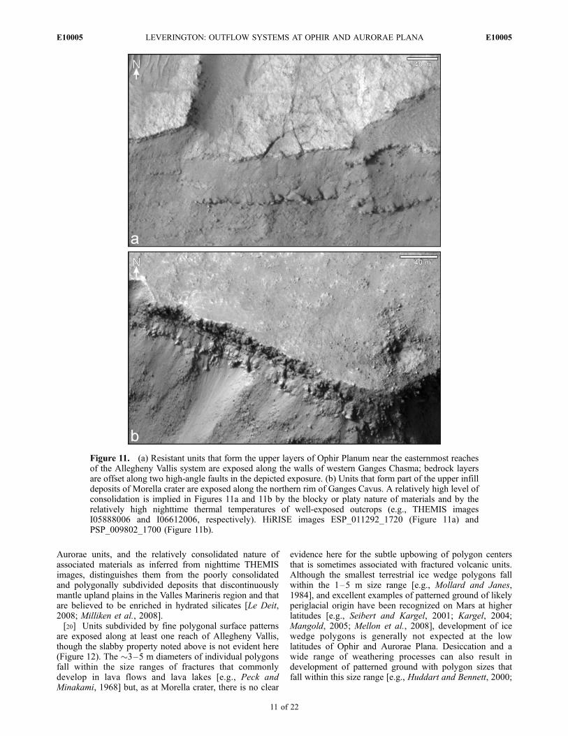
Figure 11. (a) Resistant units that form the upper layers of Ophir Planum near the easternmost reachesof the Allegheny Vallis system are exposed along the walls of western Ganges Chasma; bedrock layersare offset along two high-angle faults in the depicted exposure. (b) Units that form part of the upper infilldeposits of Morella crater are exposed along the northern rim of Ganges Cavus. A relatively high level ofconsolidation is implied in Figures 11a and 11b by the blocky or platy nature of materials and by therelatively high nighttime thermal temperatures of well-exposed outcrops (e.g., THEMIS imagesI05888006 and I06612006, respectively). HiRISE images ESP_011292_1720 (Figure 11a) andPSP_009802_1700 (Figure 11b).
E10005 LEVERINGTON: OUTFLOW SYSTEMS AT OPHIR AND AURORAE PLANA
11 of 22
E10005
Chan et al., 2008], and represent candidate mechanisms forformation of this surface texture.[21] Boulder-rich residual mantles are locally found
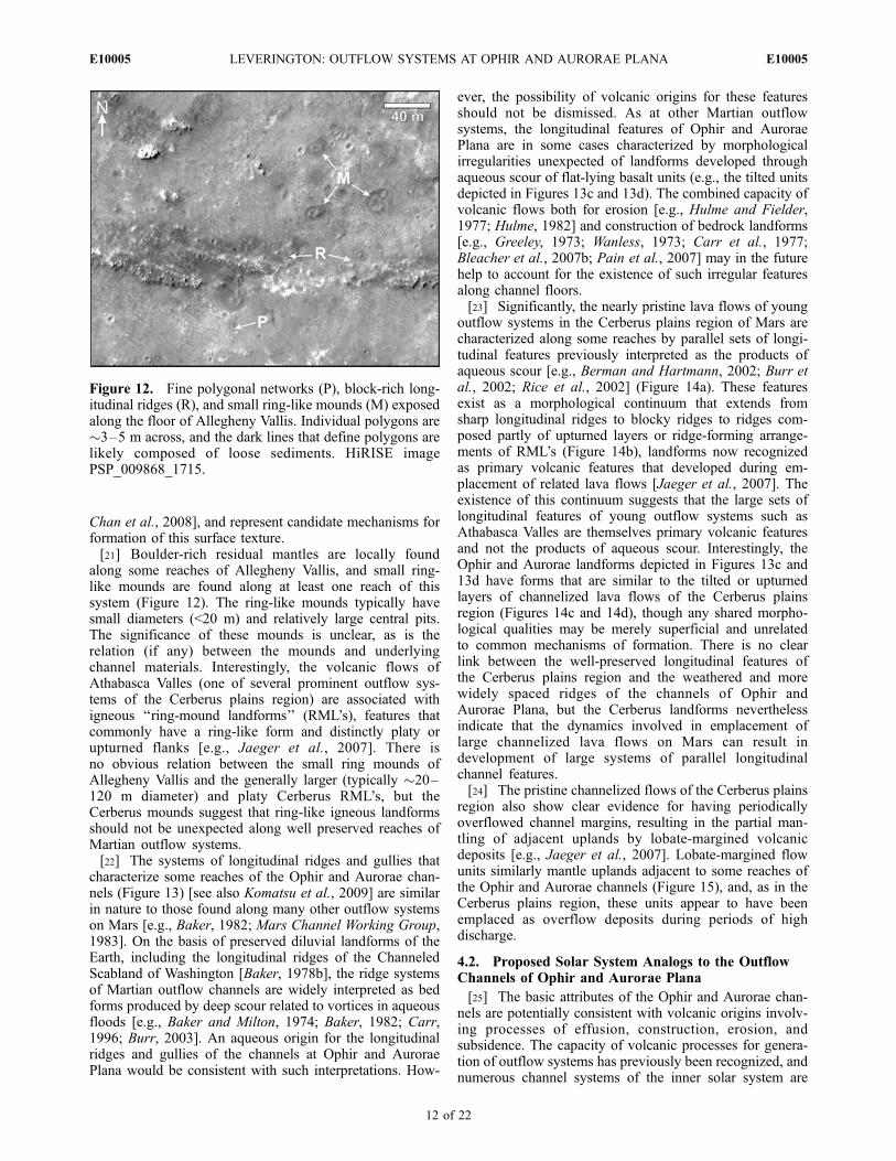
along some reaches of Allegheny Vallis, and small ring-like mounds are found along at least one reach of thissystem (Figure 12). The ring-like mounds typically havesmall diameters (<20 m) and relatively large central pits.The significance of these mounds is unclear, as is therelation (if any) between the mounds and underlyingchannel materials. Interestingly, the volcanic flows ofAthabasca Valles (one of several prominent outflow sys-tems of the Cerberus plains region) are associated withigneous ‘‘ring-mound landforms’’ (RML’s), features thatcommonly have a ring-like form and distinctly platy orupturned flanks [e.g., Jaeger et al., 2007]. There isno obvious relation between the small ring mounds ofAllegheny Vallis and the generally larger (typically �20–120 m diameter) and platy Cerberus RML’s, but theCerberus mounds suggest that ring-like igneous landformsshould not be unexpected along well preserved reaches ofMartian outflow systems.[22] The systems of longitudinal ridges and gullies that
characterize some reaches of the Ophir and Aurorae chan-nels (Figure 13) [see also Komatsu et al., 2009] are similarin nature to those found along many other outflow systemson Mars [e.g., Baker, 1982; Mars Channel Working Group,1983]. On the basis of preserved diluvial landforms of theEarth, including the longitudinal ridges of the ChanneledScabland of Washington [Baker, 1978b], the ridge systemsof Martian outflow channels are widely interpreted as bedforms produced by deep scour related to vortices in aqueousfloods [e.g., Baker and Milton, 1974; Baker, 1982; Carr,1996; Burr, 2003]. An aqueous origin for the longitudinalridges and gullies of the channels at Ophir and AuroraePlana would be consistent with such interpretations. How-
ever, the possibility of volcanic origins for these featuresshould not be dismissed. As at other Martian outflowsystems, the longitudinal features of Ophir and AuroraePlana are in some cases characterized by morphologicalirregularities unexpected of landforms developed throughaqueous scour of flat-lying basalt units (e.g., the tilted unitsdepicted in Figures 13c and 13d). The combined capacity ofvolcanic flows both for erosion [e.g., Hulme and Fielder,1977; Hulme, 1982] and construction of bedrock landforms[e.g., Greeley, 1973; Wanless, 1973; Carr et al., 1977;Bleacher et al., 2007b; Pain et al., 2007] may in the futurehelp to account for the existence of such irregular featuresalong channel floors.[23] Significantly, the nearly pristine lava flows of young
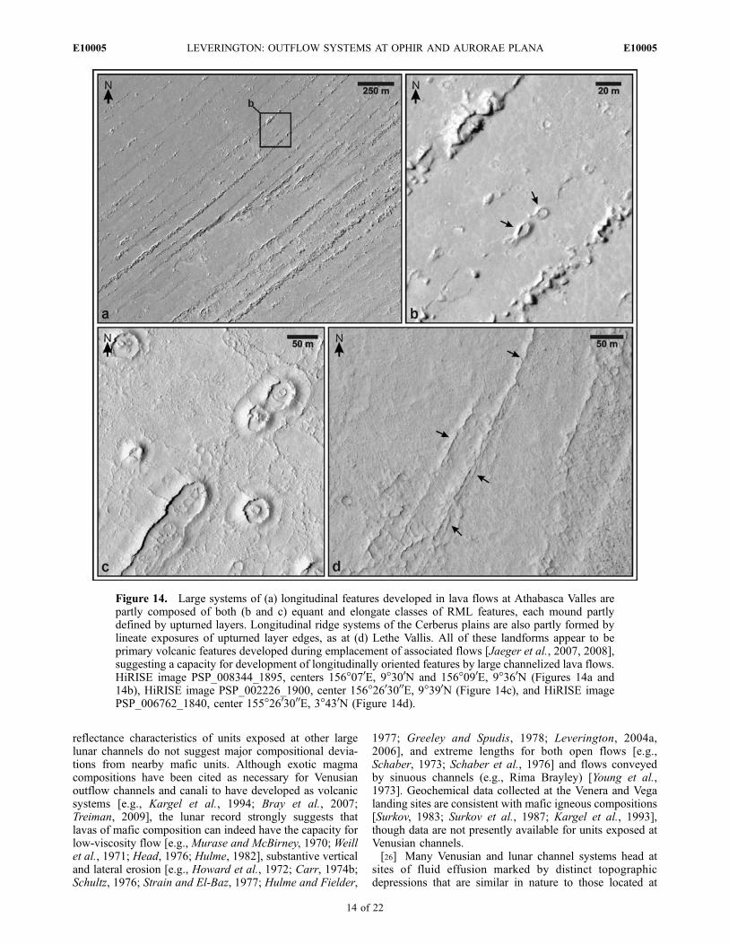
outflow systems in the Cerberus plains region of Mars arecharacterized along some reaches by parallel sets of longi-tudinal features previously interpreted as the products ofaqueous scour [e.g., Berman and Hartmann, 2002; Burr etal., 2002; Rice et al., 2002] (Figure 14a). These featuresexist as a morphological continuum that extends fromsharp longitudinal ridges to blocky ridges to ridges com-posed partly of upturned layers or ridge-forming arrange-ments of RML’s (Figure 14b), landforms now recognizedas primary volcanic features that developed during em-placement of related lava flows [Jaeger et al., 2007]. Theexistence of this continuum suggests that the large sets oflongitudinal features of young outflow systems such asAthabasca Valles are themselves primary volcanic featuresand not the products of aqueous scour. Interestingly, theOphir and Aurorae landforms depicted in Figures 13c and13d have forms that are similar to the tilted or upturnedlayers of channelized lava flows of the Cerberus plainsregion (Figures 14c and 14d), though any shared morpho-logical qualities may be merely superficial and unrelatedto common mechanisms of formation. There is no clearlink between the well-preserved longitudinal features ofthe Cerberus plains region and the weathered and morewidely spaced ridges of the channels of Ophir andAurorae Plana, but the Cerberus landforms neverthelessindicate that the dynamics involved in emplacement oflarge channelized lava flows on Mars can result indevelopment of large systems of parallel longitudinalchannel features.[24] The pristine channelized flows of the Cerberus plains
region also show clear evidence for having periodicallyoverflowed channel margins, resulting in the partial man-tling of adjacent uplands by lobate-margined volcanicdeposits [e.g., Jaeger et al., 2007]. Lobate-margined flowunits similarly mantle uplands adjacent to some reaches ofthe Ophir and Aurorae channels (Figure 15), and, as in theCerberus plains region, these units appear to have beenemplaced as overflow deposits during periods of highdischarge.
4.2. Proposed Solar System Analogs to the OutflowChannels of Ophir and Aurorae Plana
[25] The basic attributes of the Ophir and Aurorae chan-nels are potentially consistent with volcanic origins involv-ing processes of effusion, construction, erosion, andsubsidence. The capacity of volcanic processes for genera-tion of outflow systems has previously been recognized, andnumerous channel systems of the inner solar system are
Figure 12. Fine polygonal networks (P), block-rich long-itudinal ridges (R), and small ring-like mounds (M) exposedalong the floor of Allegheny Vallis. Individual polygons are�3–5 m across, and the dark lines that define polygons arelikely composed of loose sediments. HiRISE imagePSP_009868_1715.
E10005 LEVERINGTON: OUTFLOW SYSTEMS AT OPHIR AND AURORAE PLANA
12 of 22
E10005

interpreted as volcanic [e.g., Greeley, 1971, 1977; Greeleyand Spudis, 1978; Schultz, 1976; Wilhelms, 1987; Baker etal., 1992, 1997; Komatsu and Baker, 1994; Oshigami et al.,2009]. For the purposes of the present paper, channels arecategorized as ‘‘outflow systems’’ on the basis of theirdevelopment through voluminous fluid effusion from thesubsurface. Although alternative aqueous interpretationshave been proposed [e.g., Jones and Pickering, 2003;Waltham et al., 2008], the outflow systems of Venus andthe Moon are generally believed to have formed throughextrusive igneous processes in the absence of water [e.g.,Greeley, 1971; Wilhelms, 1987; Baker et al., 1992, 1997].
Igneous interpretations of these systems are based in partupon the widespread association of channel systems withvolcanic landscapes and flows, the apparently depletednature of Venus and the Moon with regard to bulk volatilecontents [e.g., Papike et al., 1991; Donahue and Russell,1997; Nimmo and McKenzie, 1998; Taylor, 2005], the likelylong-term instability of water at the surfaces of Venus andthe Moon [e.g., Wilhelms, 1987; Kargel et al., 1993; Taylor,2005], and the absence of associated landforms suggestiveof past wet conditions. Samples collected at lunar RimaHadley are predominantly of basaltic composition and lackaqueous alteration [e.g., Swann et al., 1972], and the
Figure 13. Longitudinal ridges exposed along channel reaches of (a–c) Elaver Vallis and (d) AlleghenyVallis. The landforms in Figures 13c and 13d have axes oriented parallel to the direction of paleoflow andappear to be partly composed of tilted or upturned layers; such landforms are unlikely to be the productsof aqueous scour of flat-lying units. THEMIS image V26886003, center 48�470W, 8�570S (Figure 13a),MOC image E0902605, center 48�190W, 8�550S (Figure 13b), HiRISE image PSP_005662_1700, center50�070W, 9�380 S (Figure 13c), and MOC image M0302478, center 53�380W, 8�360S (Figure 13d).
E10005 LEVERINGTON: OUTFLOW SYSTEMS AT OPHIR AND AURORAE PLANA
13 of 22
E10005
reflectance characteristics of units exposed at other largelunar channels do not suggest major compositional devia-tions from nearby mafic units. Although exotic magmacompositions have been cited as necessary for Venusianoutflow channels and canali to have developed as volcanicsystems [e.g., Kargel et al., 1994; Bray et al., 2007;Treiman, 2009], the lunar record strongly suggests thatlavas of mafic composition can indeed have the capacity forlow-viscosity flow [e.g., Murase and McBirney, 1970; Weillet al., 1971; Head, 1976; Hulme, 1982], substantive verticaland lateral erosion [e.g., Howard et al., 1972; Carr, 1974b;Schultz, 1976; Strain and El-Baz, 1977; Hulme and Fielder,
1977; Greeley and Spudis, 1978; Leverington, 2004a,2006], and extreme lengths for both open flows [e.g.,Schaber, 1973; Schaber et al., 1976] and flows conveyedby sinuous channels (e.g., Rima Brayley) [Young et al.,1973]. Geochemical data collected at the Venera and Vegalanding sites are consistent with mafic igneous compositions[Surkov, 1983; Surkov et al., 1987; Kargel et al., 1993],though data are not presently available for units exposed atVenusian channels.[26] Many Venusian and lunar channel systems head at
sites of fluid effusion marked by distinct topographicdepressions that are similar in nature to those located at
Figure 14. Large systems of (a) longitudinal features developed in lava flows at Athabasca Valles arepartly composed of both (b and c) equant and elongate classes of RML features, each mound partlydefined by upturned layers. Longitudinal ridge systems of the Cerberus plains are also partly formed bylineate exposures of upturned layer edges, as at (d) Lethe Vallis. All of these landforms appear to beprimary volcanic features developed during emplacement of associated flows [Jaeger et al., 2007, 2008],suggesting a capacity for development of longitudinally oriented features by large channelized lava flows.HiRISE image PSP_008344_1895, centers 156�070E, 9�300N and 156�090E, 9�360N (Figures 14a and14b), HiRISE image PSP_002226_1900, center 156�2603000E, 9�390N (Figure 14c), and HiRISE imagePSP_006762_1840, center 155�2603000E, 3�430N (Figure 14d).
E10005 LEVERINGTON: OUTFLOW SYSTEMS AT OPHIR AND AURORAE PLANA
14 of 22
E10005
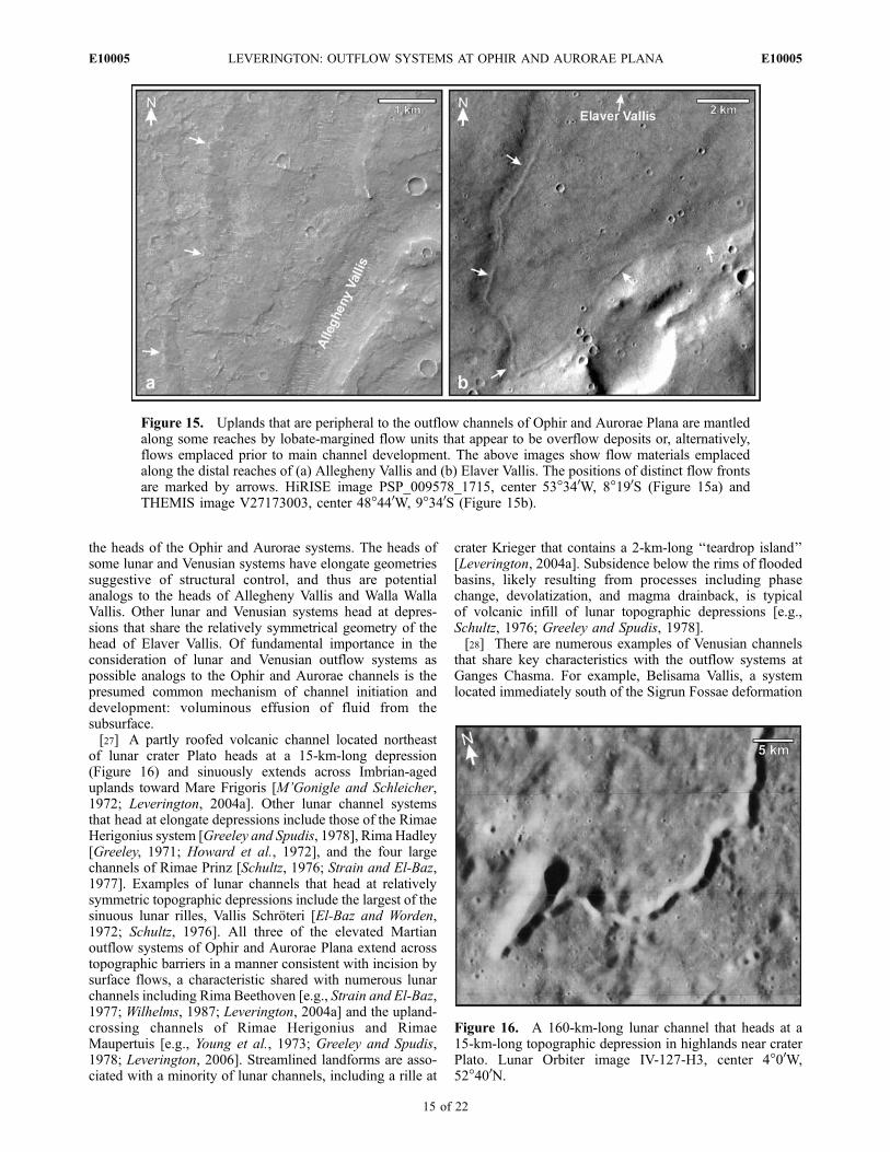
the heads of the Ophir and Aurorae systems. The heads ofsome lunar and Venusian systems have elongate geometriessuggestive of structural control, and thus are potentialanalogs to the heads of Allegheny Vallis and Walla WallaVallis. Other lunar and Venusian systems head at depres-sions that share the relatively symmetrical geometry of thehead of Elaver Vallis. Of fundamental importance in theconsideration of lunar and Venusian outflow systems aspossible analogs to the Ophir and Aurorae channels is thepresumed common mechanism of channel initiation anddevelopment: voluminous effusion of fluid from thesubsurface.[27] A partly roofed volcanic channel located northeast
of lunar crater Plato heads at a 15-km-long depression(Figure 16) and sinuously extends across Imbrian-ageduplands toward Mare Frigoris [M’Gonigle and Schleicher,1972; Leverington, 2004a]. Other lunar channel systemsthat head at elongate depressions include those of the RimaeHerigonius system [Greeley and Spudis, 1978], Rima Hadley[Greeley, 1971; Howard et al., 1972], and the four largechannels of Rimae Prinz [Schultz, 1976; Strain and El-Baz,1977]. Examples of lunar channels that head at relativelysymmetric topographic depressions include the largest of thesinuous lunar rilles, Vallis Schroteri [El-Baz and Worden,1972; Schultz, 1976]. All three of the elevated Martianoutflow systems of Ophir and Aurorae Plana extend acrosstopographic barriers in a manner consistent with incision bysurface flows, a characteristic shared with numerous lunarchannels including Rima Beethoven [e.g., Strain and El-Baz,1977; Wilhelms, 1987; Leverington, 2004a] and the upland-crossing channels of Rimae Herigonius and RimaeMaupertuis [e.g., Young et al., 1973; Greeley and Spudis,1978; Leverington, 2006]. Streamlined landforms are asso-ciated with a minority of lunar channels, including a rille at
crater Krieger that contains a 2-km-long ‘‘teardrop island’’[Leverington, 2004a]. Subsidence below the rims of floodedbasins, likely resulting from processes including phasechange, devolatization, and magma drainback, is typicalof volcanic infill of lunar topographic depressions [e.g.,Schultz, 1976; Greeley and Spudis, 1978].[28] There are numerous examples of Venusian channels
that share key characteristics with the outflow systems atGanges Chasma. For example, Belisama Vallis, a systemlocated immediately south of the Sigrun Fossae deformation
Figure 15. Uplands that are peripheral to the outflow channels of Ophir and Aurorae Plana are mantledalong some reaches by lobate-margined flow units that appear to be overflow deposits or, alternatively,flows emplaced prior to main channel development. The above images show flow materials emplacedalong the distal reaches of (a) Allegheny Vallis and (b) Elaver Vallis. The positions of distinct flow frontsare marked by arrows. HiRISE image PSP_009578_1715, center 53�340W, 8�190S (Figure 15a) andTHEMIS image V27173003, center 48�440W, 9�340S (Figure 15b).
Figure 16. A 160-km-long lunar channel that heads at a15-km-long topographic depression in highlands near craterPlato. Lunar Orbiter image IV-127-H3, center 4�00W,52�400N.
E10005 LEVERINGTON: OUTFLOW SYSTEMS AT OPHIR AND AURORAE PLANA
15 of 22
E10005
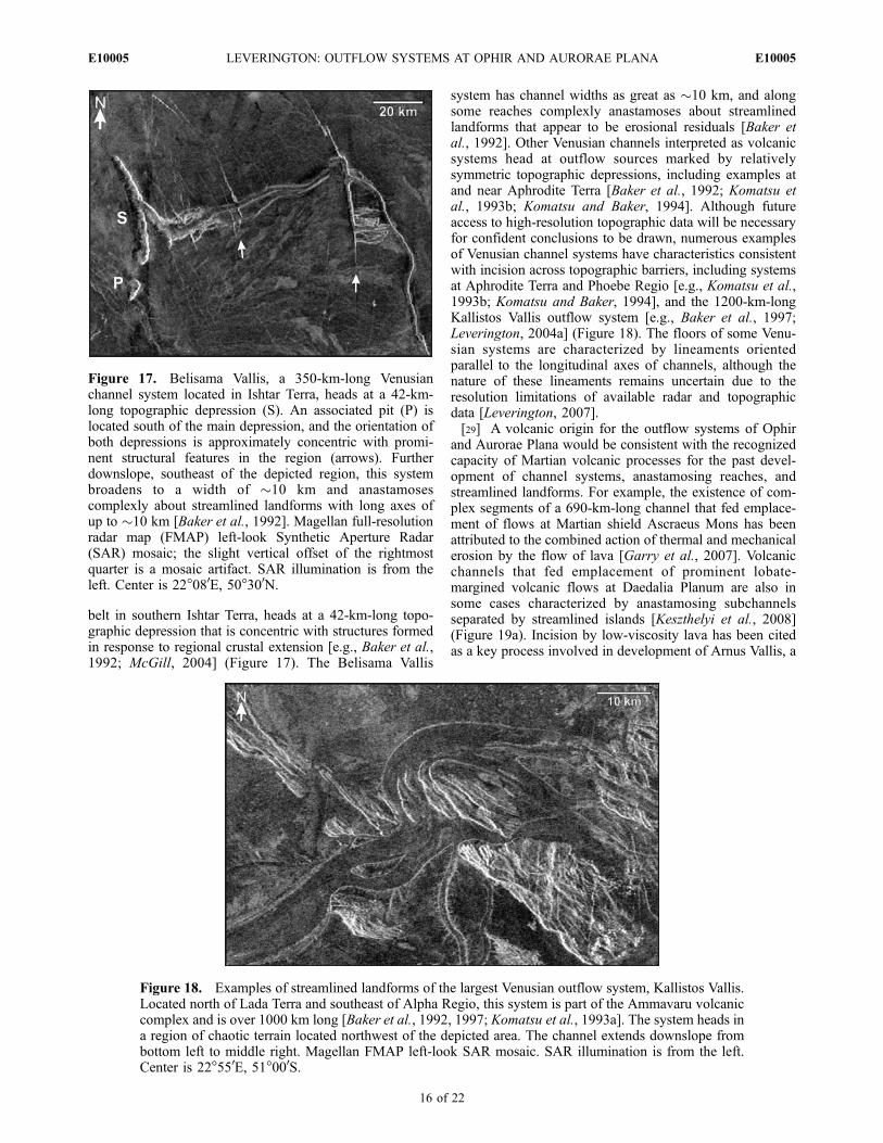
belt in southern Ishtar Terra, heads at a 42-km-long topo-graphic depression that is concentric with structures formedin response to regional crustal extension [e.g., Baker et al.,1992; McGill, 2004] (Figure 17). The Belisama Vallis
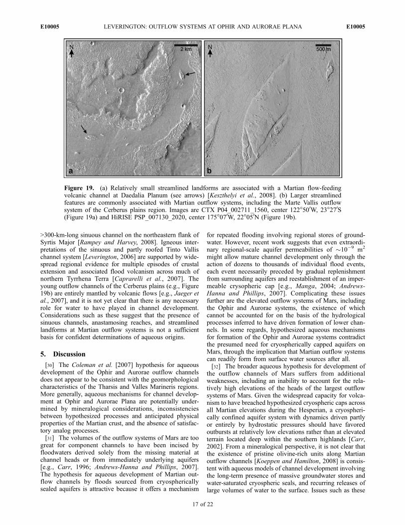
system has channel widths as great as �10 km, and alongsome reaches complexly anastamoses about streamlinedlandforms that appear to be erosional residuals [Baker etal., 1992]. Other Venusian channels interpreted as volcanicsystems head at outflow sources marked by relativelysymmetric topographic depressions, including examples atand near Aphrodite Terra [Baker et al., 1992; Komatsu etal., 1993b; Komatsu and Baker, 1994]. Although futureaccess to high-resolution topographic data will be necessaryfor confident conclusions to be drawn, numerous examplesof Venusian channel systems have characteristics consistentwith incision across topographic barriers, including systemsat Aphrodite Terra and Phoebe Regio [e.g., Komatsu et al.,1993b; Komatsu and Baker, 1994], and the 1200-km-longKallistos Vallis outflow system [e.g., Baker et al., 1997;Leverington, 2004a] (Figure 18). The floors of some Venu-sian systems are characterized by lineaments orientedparallel to the longitudinal axes of channels, although thenature of these lineaments remains uncertain due to theresolution limitations of available radar and topographicdata [Leverington, 2007].[29] A volcanic origin for the outflow systems of Ophir
and Aurorae Plana would be consistent with the recognizedcapacity of Martian volcanic processes for the past devel-opment of channel systems, anastamosing reaches, andstreamlined landforms. For example, the existence of com-plex segments of a 690-km-long channel that fed emplace-ment of flows at Martian shield Ascraeus Mons has beenattributed to the combined action of thermal and mechanicalerosion by the flow of lava [Garry et al., 2007]. Volcanicchannels that fed emplacement of prominent lobate-margined volcanic flows at Daedalia Planum are also insome cases characterized by anastamosing subchannelsseparated by streamlined islands [Keszthelyi et al., 2008](Figure 19a). Incision by low-viscosity lava has been citedas a key process involved in development of Arnus Vallis, a
Figure 17. Belisama Vallis, a 350-km-long Venusianchannel system located in Ishtar Terra, heads at a 42-km-long topographic depression (S). An associated pit (P) islocated south of the main depression, and the orientation ofboth depressions is approximately concentric with promi-nent structural features in the region (arrows). Furtherdownslope, southeast of the depicted region, this systembroadens to a width of �10 km and anastamosescomplexly about streamlined landforms with long axes ofup to �10 km [Baker et al., 1992]. Magellan full-resolutionradar map (FMAP) left-look Synthetic Aperture Radar(SAR) mosaic; the slight vertical offset of the rightmostquarter is a mosaic artifact. SAR illumination is from theleft. Center is 22�080E, 50�300N.
Figure 18. Examples of streamlined landforms of the largest Venusian outflow system, Kallistos Vallis.Located north of Lada Terra and southeast of Alpha Regio, this system is part of the Ammavaru volcaniccomplex and is over 1000 km long [Baker et al., 1992, 1997; Komatsu et al., 1993a]. The system heads ina region of chaotic terrain located northwest of the depicted area. The channel extends downslope frombottom left to middle right. Magellan FMAP left-look SAR mosaic. SAR illumination is from the left.Center is 22�550E, 51�000S.
E10005 LEVERINGTON: OUTFLOW SYSTEMS AT OPHIR AND AURORAE PLANA
16 of 22
E10005
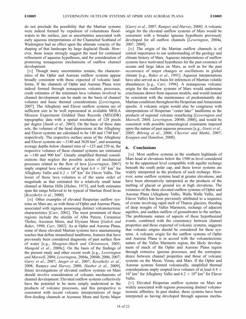
>300-km-long sinuous channel on the northeastern flank ofSyrtis Major [Rampey and Harvey, 2008]. Igneous inter-pretations of the sinuous and partly roofed Tinto Vallischannel system [Leverington, 2006] are supported by wide-spread regional evidence for multiple episodes of crustalextension and associated flood volcanism across much ofnorthern Tyrrhena Terra [Caprarelli et al., 2007]. Theyoung outflow channels of the Cerberus plains (e.g., Figure19b) are entirely mantled by volcanic flows [e.g., Jaeger etal., 2007], and it is not yet clear that there is any necessaryrole for water to have played in channel development.Considerations such as these suggest that the presence ofsinuous channels, anastamosing reaches, and streamlinedlandforms at Martian outflow systems is not a sufficientbasis for confident determinations of aqueous origins.
5. Discussion
[30] The Coleman et al. [2007] hypothesis for aqueousdevelopment of the Ophir and Aurorae outflow channelsdoes not appear to be consistent with the geomorphologicalcharacteristics of the Tharsis and Valles Marineris regions.More generally, aqueous mechanisms for channel develop-ment at Ophir and Aurorae Plana are potentially under-mined by mineralogical considerations, inconsistenciesbetween hypothesized processes and anticipated physicalproperties of the Martian crust, and the absence of satisfac-tory analog processes.[31] The volumes of the outflow systems of Mars are too
great for component channels to have been incised byfloodwaters derived solely from the missing material atchannel heads or from immediately underlying aquifers[e.g., Carr, 1996; Andrews-Hanna and Phillips, 2007].The hypothesis for aqueous development of Martian out-flow channels by floods sourced from cryosphericallysealed aquifers is attractive because it offers a mechanism
for repeated flooding involving regional stores of ground-water. However, recent work suggests that even extraordi-nary regional-scale aquifer permeabilities of �10�9 m2
might allow mature channel development only through theaction of dozens to thousands of individual flood events,each event necessarily preceded by gradual replenishmentfrom surrounding aquifers and reestablishment of an imper-meable crysopheric cap [e.g., Manga, 2004; Andrews-Hanna and Phillips, 2007]. Complicating these issuesfurther are the elevated outflow systems of Mars, includingthe Ophir and Aurorae systems, the existence of whichcannot be accounted for on the basis of the hydrologicalprocesses inferred to have driven formation of lower chan-nels. In some regards, hypothesized aqueous mechanismsfor formation of the Ophir and Aurorae systems contradictthe presumed need for cryospherically capped aquifers onMars, through the implication that Martian outflow systemscan readily form from surface water sources after all.[32] The broader aqueous hypothesis for development of
the outflow channels of Mars suffers from additionalweaknesses, including an inability to account for the rela-tively high elevations of the heads of the largest outflowsystems of Mars. Given the widespread capacity for volca-nism to have breached hypothesized cryospheric caps acrossall Martian elevations during the Hesperian, a cryospheri-cally confined aquifer system with dynamics driven partlyor entirely by hydrostatic pressures should have favoredoutbursts at relatively low elevations rather than at elevatedterrain located deep within the southern highlands [Carr,2002]. From a mineralogical perspective, it is not clear thatthe existence of pristine olivine-rich units along Martianoutflow channels [Koeppen and Hamilton, 2008] is consis-tent with aqueous models of channel development involvingthe long-term presence of massive groundwater stores andwater-saturated cryospheric seals, and recurring releases oflarge volumes of water to the surface. Issues such as these
Figure 19. (a) Relatively small streamlined landforms are associated with a Martian flow-feedingvolcanic channel at Daedalia Planum (see arrows) [Keszthelyi et al., 2008]. (b) Larger streamlinedfeatures are commonly associated with Martian outflow systems, including the Marte Vallis outflowsystem of the Cerberus plains region. Images are CTX P04_002711_1560, center 122�500W, 23�270S(Figure 19a) and HiRISE PSP_007130_2020, center 175�070W, 22�050N (Figure 19b).
E10005 LEVERINGTON: OUTFLOW SYSTEMS AT OPHIR AND AURORAE PLANA
17 of 22
E10005
do not preclude the possibility that the Martian systemswere indeed formed by expulsion of voluminous flood-waters to the surface, just as uncertainties associated withearly aqueous interpretations of the Channeled Scabland ofWashington had no effect upon the ultimate veracity of theshaping of that landscape by large deglacial floods. How-ever, these issues strongly suggest the need for continuedrefinement of aqueous hypotheses, and for consideration ofpromising nonaqueous mechanisms of outflow channeldevelopment.[33] Though many uncertainties remain, the character-
istics of the Ophir and Aurorae outflow systems appearbroadly consistent with those expected of volcanic land-forms. If the channels of Ophir and Aurorae Plana wereindeed formed through nonaqueous volcanic processes,crude estimates of the minimum lava volumes involved inchannel development can be made on the basis of channelvolumes and basic thermal considerations [Leverington,2007]. The Allegheny and Elaver outflow systems are ofsufficient size to be well represented in available MOLAMission Experiment Gridded Data Records (MEGDR)topographic data with a spatial resolution of 128 pixelsper degree [Smith et al., 2003]. On the basis of these datasets, the volumes of the head depressions at the Alleghenyand Elaver systems are calculated to be 140 and 1740 km3,respectively. The respective surface areas of the Alleghenyand Elaver systems are �1140 and 3620 km2, and assumingaverage depths below channel rims of �125 and 250 m, therespective volumes of these channel systems are estimatedas �140 and 900 km3. Greatly simplified thermal consid-erations that neglect the possible action of mechanicalprocesses related to the flow of lava [Leverington, 2007]imply erupted lava volumes of at least 6.4 � 103 km3 forAllegheny Vallis and 6.2 � 104 km3 for Elaver Vallis. Thelesser of these lava volumes is of the same order ofmagnitude as that estimated for a relatively small lunarchannel at Marius Hills [Hulme, 1973], and both estimatesspan the range believed to be typical of Martian flood lavas[Keszthelyi et al., 2000].[34] Other examples of elevated Hesperian outflow sys-
tems on Mars are, as with those of Ophir and Aurorae Plana,associated with regions possessing distinct volcanotectoniccharacteristics [Carr, 2002]. The most prominent of theseregions include the shields of Alba Patera, CerauniusTholus, Ascraeus Mons, and Elysium Mons [Gulick andBaker, 1990; Carr, 2002]. As at Ophir and Aurorae Plana,some of these elevated Martian systems have anastamosingreaches that define streamlined landforms, features that havepreviously been considered diagnostic of past surface flowof water [e.g., Mouginis-Mark and Christensen, 2005;Mangold et al., 2008c]. On the basis of the findings ofthe present study and other recent work [e.g., Leveringtonand Maxwell, 2004; Leverington, 2004a, 2004b, 2006, 2007;Garry et al., 2007; Jaeger et al., 2007; Keszthelyi et al.,2008; Rampey and Harvey, 2008; Hauber et al., 2009],future investigations of elevated outflow systems on Marsshould involve consideration of volcanic mechanisms ofchannel development. Elevated outflow systems collectivelyhave the potential to be more simply understood as theproducts of volcanic processes, and this perspective isconsistent with recent volcanic interpretations of largeflow-feeding channels at Ascraeus Mons and Syrtis Major
[Garry et al., 2007; Rampey and Harvey, 2008]. A volcanicorigin for the elevated outflow systems of Mars would beconsistent with a broader igneous hypothesis previouslydeveloped for all outflow channels [Leverington, 2004a,2007, 2009].[35] The origin of the Martian outflow channels is of
central importance to our understanding of the geology andclimate history of Mars. Aqueous interpretations of outflowsystems have motivated hypotheses for the past existence ofoceans and large lakes on Mars, as well as for the pastoccurrence of major changes or oscillations in globalclimate [e.g., Baker et al., 1991]. Aqueous interpretationshave also served as a basis for inferences of Martian volatileabundances [e.g., Carr, 1996]. A nonaqueous volcanicorigin for the outflow systems of Mars would undermineconclusions drawn from aqueous models, and would insteadbe consistent with the maintenance of predominantly dryMartian conditions throughout the Hesperian andAmazonianepochs. A volcanic origin would also be congruous withinterpretations of Hesperian ‘‘crater lake’’ landforms as theproducts of regional volcanic resurfacing [Leverington andMaxwell, 2004; Leverington, 2004b, 2006], and would beconsistent with possible mineralogical constraints imposedupon the nature of past aqueous processes [e.g., Goetz et al.,2005; Bibring et al., 2006; Chevrier and Mathe, 2007;Koeppen and Hamilton, 2008].
6. Conclusions
[36] Most outflow systems in the southern highlands ofMars head at elevations below the 1500 m level consideredto be the uppermost level compatible with aquifer rechargebeneath the south polar cap, and these lower systems arewidely interpreted as the products of such recharge. How-ever, some outflow systems head at greater elevations, andhave been alternatively interpreted as the products of themelting of glacial or ground ice at high elevations. Theexistence of the three elevated outflow systems of Ophir andAurorae Plana (Allegheny Vallis, Walla Walla Vallis, andElaver Vallis) has been previously attributed to a sequenceof events involving rapid melt of Tharsis glaciers, floodingof deep troughs of Valles Marineris, recharge of adjacentaquifers, and sudden outflow of groundwater to the surface.The problematic nature of aspects of these hypothesizedevents, combined with the consistency between channelproperties and those expected of volcanic systems, suggeststhat volcanic origins should be considered for these sys-tems. A volcanic origin for the outflow systems of Ophirand Aurorae Plana is in accord with the volcanotectonicnature of the Valles Marineris region, the likely develop-ment of much of the Ophir and Aurorae Plana regionthrough extrusive igneous processes, and the correspon-dence between channel properties and those of volcanicsystems on the Moon, Venus, and Mars. If the Ophir andAurorae systems formed volcanically, simplified thermalconsiderations imply erupted lava volumes of at least 6.4 �103 km3 for Allegheny Vallis and 6.2 � 104 km3 for ElaverVallis.[37] Elevated Hesperian outflow systems on Mars are
widely associated with regions possessing distinct volcano-tectonic affinities. In past studies, these systems have beeninterpreted as having developed through aqueous mecha-
E10005 LEVERINGTON: OUTFLOW SYSTEMS AT OPHIR AND AURORAE PLANA
18 of 22
E10005

nisms involving the melting of glacial or ground ice, but, asat Ophir and Aurorae Plana, these systems have the potentialto be more simply understood as the products of volcanicprocesses. Avolcanic origin for the elevated outflow systemsof Mars would be consistent with a broader igneous hypoth-esis previously developed for all outflow channels.
[38] Acknowledgments. The helpful comments of Goro Komatsuand an anonymous reader are appreciated. The author acknowledges theuse of Mars Orbiter Camera images processed by Malin Space ScienceSystems and Thermal Emission Imaging System images processed byArizona State University.
ReferencesAndrews-Hanna, J. C., and R. J. Phillips (2007), Hydrological modeling ofoutflow channels and chaos regions on Mars, J. Geophys. Res., 112,E08001, doi:10.1029/2006JE002881.
Baker, V. R. (1978a), Quaternary geology of the Channeled Scabland andadjacent areas, in The Channeled Scabland: A Guide to the Geomor-phology of the Columbia Basin, Washington, edited by V. R. Baker andD. Nummedal, pp. 17–35, NASA, Washington, D. C.
Baker, V. R. (1978b), Large-scale erosional and depositional features of theChanneled Scabland, in The Channeled Scabland: A Guide to the Geo-morphology of the Columbia Basin, Washington, edited by V. R. Bakerand D. Nummedal, pp. 81–115, NASA, Washington, D. C.
Baker, V. R. (1982), The Channels of Mars, Univ. of Tex. Press, Austin.Baker, V. R. (2001), Water and the Martian landscape, Nature, 412, 228–236, doi:10.1038/35084172.
Baker, V. R., and D. J. Milton (1974), Erosion by catastrophic floods onMars and Earth, Icarus, 23, 27–41, doi:10.1016/0019-1035(74)90101-8.
Baker, V. R., R. G. Strom, V. C. Gulick, J. S. Kargel, G. Komatsu, and V. S.Kale (1991), Ancient oceans, ice sheets, and the hydrological cycle onMars, Nature, 352, 589–594, doi:10.1038/352589a0.
Baker, V. R., G. Komatsu, T. J. Parker, V. C. Gulick, J. S. Kargel, and J. S.Lewis (1992), Channels and valleys on Venus: Preliminary analysis ofMagellan data, J. Geophys. Res., 97, 13,421 –13,444, doi:10.1029/92JE00927.
Baker, V. R., G. Komatsu, V. C. Gulick, and T. J. Parker (1997), Channelsand valleys, in Venus II, edited by S. W. Bougher et al., pp. 757–793,Univ. of Ariz. Press, Tucson.
Baloga, S. M., P. J. Mouginis-Mark, and L. S. Glaze (2003), Rheology of along lava flow at Pavonis Mons, Mars, J. Geophys. Res., 108(E7), 5066,doi:10.1029/2002JE001981.
Baptista,A.R.,N.Mangold,V.Ansan,D.Baratoux,P.Lognonne,E.I.Alves,Alves,Alves, D. A. Williams, J. E. Bleacher, P. Masson, and G. Neukum (2008),A swarm of small shield volcanoes on Syria Planum, Mars, J. Geophys.Res., 113, E09010, doi:10.1029/2007JE002945.
Battistini, R. (1984), Morphology and origin of ridges in low-latitude areasof Mars, Earth Moon Planets, 31(1), 49–61, doi:10.1007/BF00058111.
Berman, D. C., and W. K. Hartmann (2002), Recent fluvial, volcanic, andtectonic activity on the Cerberus Plains of Mars, Icarus, 159, 1 –17,doi:10.1006/icar.2002.6920.
Beyer, R. A., and A. S. McEwen (2005), Layering stratigraphy of easternCoprates and northern Capri Chasmata, Mars, Icarus, 179, 1 – 23,doi:10.1016/j.icarus.2005.06.014.
Beyer, R. A., C. M. Weitz, B. J. Thompson, J. M. Moore, A. S. McEwen,and the HiRISE Team (2007), HiRISE observations of Valles Marinerislayering, in Seventh International Conference on Mars, July 9–13, 2007,Pasadena CA [CD-ROM], LPI Contrib., 1353, Abstract 3310.
Bibring, J-P., et al. (2006), Global mineralogical and aqueous Mars historyderived from OMEGA/Mars Express Data, Science, 312, 400–404.
Bleacher, J. E., R. Greeley, D. A. Williams, S. R. Cave, and G. Neukum(2007a), Trends in effusive style at the Tharsis Montes, Mars, andimplications for the development of the Tharsis province, J. Geophys.Res., 112, E09005, doi:10.1029/2006JE002873.
Bleacher, J. E., R. Greeley, D. A. Williams, S. C. Werner, E. Hauber, andG. Neukum (2007b), Olympus Mons, Mars: Inferred changes in lateAmazonian aged effusive activity from lava flow mapping of MarsExpress High Resolution Stereo Camera data, J. Geophys. Res., 112,E04003, doi:10.1029/2006JE002826.
Borraccini, F., G. Di Achille, G. G. Ori, and F. C. Wezel (2007), Tectonicevolution of the eastern margin of the Thaumasia Plateau (Mars) asinferred from detailed structural mapping and analysis, J. Geophys.Res., 112, E05005, doi:10.1029/2006JE002866.
Bourke, M. C., J. Clark, M. Manga, P. Nelson, K. Williams, J. Fonesca, andB. Fobar (2007), Spring mounds and channels at Dalhousie, CentralAustralia, Lunar Planet. Sci., XXXVIII, Abstract 2174.
Bray, V. J., D. B. J. Bussey, R. C. Ghail, A. P. Jones, and K. T. Pickering(2007), Meander geometry of Venusian canali: Constraints on flowregime and formation time, J. Geophys. Res. , 112 , E04S05,doi:10.1029/2006JE002785.
Bretz, J. H., H. T. U. Smith, and G. E. Neff (1956), Channeled Scabland ofWashington: New data and interpretations, Geol. Soc. Am. Bull., 67,957–1049, doi:10.1130/0016-7606(1956)67[957:CSOWND]2.0.CO;2.
Bryan, W. B. (1973), Wrinkle-ridges as deformed surface crust on pondedmare lava, Proc. Lunar Sci. Conf., 4th, 93–106.
Burr, D. M. (2003), Hydraulic modelling of Athabasca Vallis, Mars,Hydrol. Sci. J., 48(4), 655–664, doi:10.1623/hysj.48.4.655.51407.
Burr, D. M., J. A. Grier, A. S. McEwen, and L. P. Keszthelyi (2002),Repeated aqueous flooding from the Cerberus Fossae: Evidence for veryrecently extant, deep groundwater on Mars, Icarus, 159, 53 – 73,doi:10.1006/icar.2002.6921.
Burr, D. M., R. J. Soare, J.-M. Wan Bun Tseung, and J. P. Emery (2005),Young (late Amazonian), near-surface, ground ice features near the equa-tor, Athabasca Valles, Mars, Icarus, 178, 56 – 73, doi:10.1016/j.icarus.2005.04.012.
Burr, D. M., K. L. Tanaka, and K. Yoshikawa (2009), Pingos on Earth andMars, Planet. Space Sci., 57, 541–555, doi:10.1016/j.pss.2008.11.003.
Caprarelli, G., M. Pondrelli, S. Di Lorenzo, L. Marinangeli, G. G. Ori,R. Greeley, and G. Neukum (2007), A description of surface featuresin north Tyrrhena Terra, Mars: Evidence for extension and lava flood-ing, Icarus, 191, 524–544, doi:10.1016/j.icarus.2007.05.009.
Carr, M. H. (1974a), Tectonism and volcanism of the Tharsis region ofMars, J. Geophys. Res., 79, 3943–3949, doi:10.1029/JB079i026p03943.
Carr, M. H. (1974b), The role of lava erosion in the formation of lunar rillesand Martian channels, Icarus , 22 , 1 – 23, doi:10.1016/0019-1035(74)90162-6.
Carr, M. H. (1979), Formation of Martian flood features by release of waterfrom confined aquifers, J. Geophys. Res., 84, 2995–3007, doi:10.1029/JB084iB06p02995.
Carr, M. H. (1996), Water on Mars, Oxford Univ. Press, New York.Carr, M. H. (2002), Elevations of water-worn features on Mars: Implica-tions for circulation of groundwater, J. Geophys. Res., 107(E12), 5131,doi:10.1029/2002JE001845.
Carr, M. H., R. Greeley, K. R. Blasius, J. E. Guest, and J. B. Murray (1977),Some Martian volcanic features as viewed from the Viking Orbiters,J. Geophys. Res., 82, 3985–4015, doi:10.1029/JS082i028p03985.
Chan, M. A., W. A. Yonkee, D. I. Netoff, W. M. Seiler, and R. L. Ford(2008), Polygonal cracks in bedrock on Earth and Mars: Implications forweathering, Icarus, 194, 65–71, doi:10.1016/j.icarus.2007.09.026.
Chevrier, V., and P. E. Mathe (2007), Mineralogy and evolution of thesurface of Mars: A review, Planet. Space Sci., 55, 289 – 314,doi:10.1016/j.pss.2006.05.039.
Chojnacki, M., and B. M. Hynek (2008), Geological context of water-altered minerals in Valles Marineris, Mars, J. Geophys. Res., 113,E12005, doi:10.1029/2007JE003070.
Christiansen, E. H. (1989), Lahars in the Elysium region of Mars, Geology,17, 203 –206, doi:10.1130/0091-7613(1989)017<0203:LITERO>2.3.CO;2.
Christensen, P. R. (2006), Water at the poles and in permafrost regions ofMars, Elements, 2, 151–155, doi:10.2113/gselements.2.3.151.
Christensen, P. R., et al. (2003), Morphology and composition of the sur-face of Mars: Mars Odyssey THEMIS results, Science, 300, 2056–2061,doi:10.1126/science.1080885.
Clifford, S. M. (1993), A model for the hydrologic and climatic behavior ofwater on Mars, J. Geophys. Res., 98, 10,973–11,016, doi:10.1029/93JE00225.
Clifford, S. M., and T. J. Parker (2001), The evolution of the Martianhydrosphere: Implications for the fate of a primordial ocean and thecurrent state of the northern plains, Icarus, 154, 40–79, doi:10.1006/icar.2001.6671.
Coleman, N. M. (2006), Formation of lakes in the ancestral Valles Mar-ineris in the epoch of Allegheny Vallis, Mars, Lunar Planet. Sci., XXXVII,Abstract 1879.
Coleman, N. M., C. L. Dinwiddie, and K. Casteel (2007), High outflowchannels on Mars indicate Hesperian recharge at low latitudes and thepresence of canyon lakes, Icarus, 189, 344 – 361, doi:10.1016/j.icarus.2007.01.020.
Cutts, J. A., W. J. Roberts, and K. R. Blasius (1978), Martian channelsformed by lava erosion, Lunar Planet. Sci., IX, Abstract 209.
Dance, M., P. L. Hancock, R. S. J. Sparks, and A. Wallman (2001), Fractureand surface crust development in a Holocene pahoehoe lava flow on theIsland of Tenerife, Canaries, J. Struct. Geol., 23, 165–182, doi:10.1016/S0191-8141(00)00089-4.
De Hon, R. A. (1992), Polygenetic origin of Hrad Vallis region of Mars,Proc. Lunar Planet Sci. Conf., 22nd, 45–51.
E10005 LEVERINGTON: OUTFLOW SYSTEMS AT OPHIR AND AURORAE PLANA
19 of 22
E10005
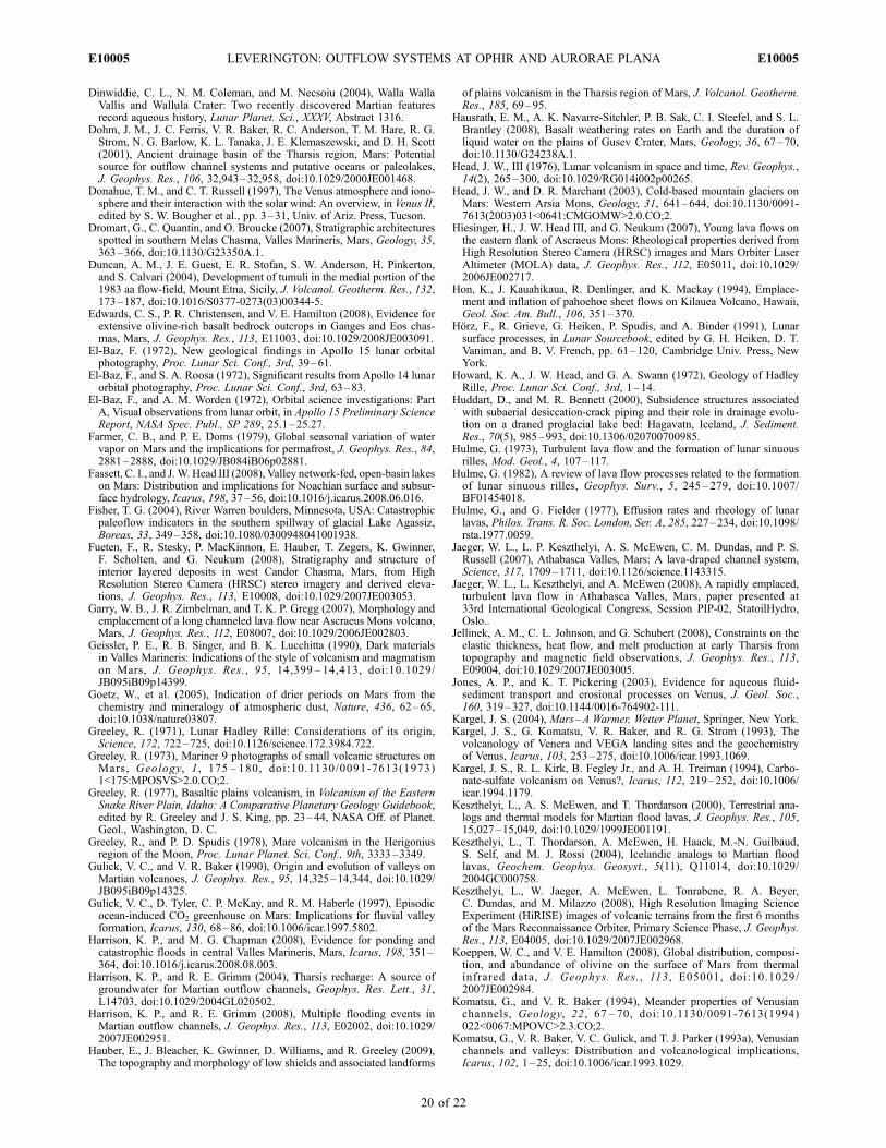
Dinwiddie, C. L., N. M. Coleman, and M. Necsoiu (2004), Walla WallaVallis and Wallula Crater: Two recently discovered Martian featuresrecord aqueous history, Lunar Planet. Sci., XXXV, Abstract 1316.
Dohm, J. M., J. C. Ferris, V. R. Baker, R. C. Anderson, T. M. Hare, R. G.Strom, N. G. Barlow, K. L. Tanaka, J. E. Klemaszewski, and D. H. Scott(2001), Ancient drainage basin of the Tharsis region, Mars: Potentialsource for outflow channel systems and putative oceans or paleolakes,J. Geophys. Res., 106, 32,943–32,958, doi:10.1029/2000JE001468.
Donahue, T. M., and C. T. Russell (1997), The Venus atmosphere and iono-sphere and their interaction with the solar wind: An overview, in Venus II,edited by S. W. Bougher et al., pp. 3–31, Univ. of Ariz. Press, Tucson.
Dromart, G., C. Quantin, and O. Broucke (2007), Stratigraphic architecturesspotted in southern Melas Chasma, Valles Marineris, Mars, Geology, 35,363–366, doi:10.1130/G23350A.1.
Duncan, A. M., J. E. Guest, E. R. Stofan, S. W. Anderson, H. Pinkerton,and S. Calvari (2004), Development of tumuli in the medial portion of the1983 aa flow-field, Mount Etna, Sicily, J. Volcanol. Geotherm. Res., 132,173–187, doi:10.1016/S0377-0273(03)00344-5.
Edwards, C. S., P. R. Christensen, and V. E. Hamilton (2008), Evidence forextensive olivine-rich basalt bedrock outcrops in Ganges and Eos chas-mas, Mars, J. Geophys. Res., 113, E11003, doi:10.1029/2008JE003091.
El-Baz, F. (1972), New geological findings in Apollo 15 lunar orbitalphotography, Proc. Lunar Sci. Conf., 3rd, 39–61.
El-Baz, F., and S. A. Roosa (1972), Significant results from Apollo 14 lunarorbital photography, Proc. Lunar Sci. Conf., 3rd, 63–83.
El-Baz, F., and A. M. Worden (1972), Orbital science investigations: PartA, Visual observations from lunar orbit, in Apollo 15 Preliminary ScienceReport, NASA Spec. Publ., SP 289, 25.1–25.27.
Farmer, C. B., and P. E. Doms (1979), Global seasonal variation of watervapor on Mars and the implications for permafrost, J. Geophys. Res., 84,2881–2888, doi:10.1029/JB084iB06p02881.
Fassett, C. I., and J.W. Head III (2008), Valley network-fed, open-basin lakeson Mars: Distribution and implications for Noachian surface and subsur-face hydrology, Icarus, 198, 37–56, doi:10.1016/j.icarus.2008.06.016.
Fisher, T. G. (2004), River Warren boulders, Minnesota, USA: Catastrophicpaleoflow indicators in the southern spillway of glacial Lake Agassiz,Boreas, 33, 349–358, doi:10.1080/0300948041001938.
Fueten, F., R. Stesky, P. MacKinnon, E. Hauber, T. Zegers, K. Gwinner,F. Scholten, and G. Neukum (2008), Stratigraphy and structure ofinterior layered deposits in west Candor Chasma, Mars, from HighResolution Stereo Camera (HRSC) stereo imagery and derived eleva-tions, J. Geophys. Res., 113, E10008, doi:10.1029/2007JE003053.
Garry, W. B., J. R. Zimbelman, and T. K. P. Gregg (2007), Morphology andemplacement of a long channeled lava flow near Ascraeus Mons volcano,Mars, J. Geophys. Res., 112, E08007, doi:10.1029/2006JE002803.
Geissler, P. E., R. B. Singer, and B. K. Lucchitta (1990), Dark materialsin Valles Marineris: Indications of the style of volcanism and magmatismon Mars, J. Geophys. Res., 95, 14,399 – 14,413, doi:10.1029/JB095iB09p14399.
Goetz, W., et al. (2005), Indication of drier periods on Mars from thechemistry and mineralogy of atmospheric dust, Nature, 436, 62–65,doi:10.1038/nature03807.
Greeley, R. (1971), Lunar Hadley Rille: Considerations of its origin,Science, 172, 722–725, doi:10.1126/science.172.3984.722.
Greeley, R. (1973), Mariner 9 photographs of small volcanic structures onMars, Geology, 1 , 175 – 180, doi:10.1130/0091-7613(1973)1<175:MPOSVS>2.0.CO;2.
Greeley, R. (1977), Basaltic plains volcanism, in Volcanism of the EasternSnake River Plain, Idaho: A Comparative Planetary Geology Guidebook,edited by R. Greeley and J. S. King, pp. 23–44, NASA Off. of Planet.Geol., Washington, D. C.
Greeley, R., and P. D. Spudis (1978), Mare volcanism in the Herigoniusregion of the Moon, Proc. Lunar Planet. Sci. Conf., 9th, 3333–3349.
Gulick, V. C., and V. R. Baker (1990), Origin and evolution of valleys onMartian volcanoes, J. Geophys. Res., 95, 14,325–14,344, doi:10.1029/JB095iB09p14325.
Gulick, V. C., D. Tyler, C. P. McKay, and R. M. Haberle (1997), Episodicocean-induced CO2 greenhouse on Mars: Implications for fluvial valleyformation, Icarus, 130, 68–86, doi:10.1006/icar.1997.5802.
Harrison, K. P., and M. G. Chapman (2008), Evidence for ponding andcatastrophic floods in central Valles Marineris, Mars, Icarus, 198, 351–364, doi:10.1016/j.icarus.2008.08.003.
Harrison, K. P., and R. E. Grimm (2004), Tharsis recharge: A source ofgroundwater for Martian outflow channels, Geophys. Res. Lett., 31,L14703, doi:10.1029/2004GL020502.
Harrison, K. P., and R. E. Grimm (2008), Multiple flooding events inMartian outflow channels, J. Geophys. Res., 113, E02002, doi:10.1029/2007JE002951.
Hauber, E., J. Bleacher, K. Gwinner, D. Williams, and R. Greeley (2009),The topography and morphology of low shields and associated landforms
of plains volcanism in the Tharsis region of Mars, J. Volcanol. Geotherm.Res., 185, 69–95.
Hausrath, E. M., A. K. Navarre-Sitchler, P. B. Sak, C. I. Steefel, and S. L.Brantley (2008), Basalt weathering rates on Earth and the duration ofliquid water on the plains of Gusev Crater, Mars, Geology, 36, 67–70,doi:10.1130/G24238A.1.
Head, J. W., III (1976), Lunar volcanism in space and time, Rev. Geophys.,14(2), 265–300, doi:10.1029/RG014i002p00265.
Head, J. W., and D. R. Marchant (2003), Cold-based mountain glaciers onMars: Western Arsia Mons, Geology, 31, 641–644, doi:10.1130/0091-7613(2003)031<0641:CMGOMW>2.0.CO;2.
Hiesinger, H., J. W. Head III, and G. Neukum (2007), Young lava flows onthe eastern flank of Ascraeus Mons: Rheological properties derived fromHigh Resolution Stereo Camera (HRSC) images and Mars Orbiter LaserAltimeter (MOLA) data, J. Geophys. Res., 112, E05011, doi:10.1029/2006JE002717.
Hon, K., J. Kauahikaua, R. Denlinger, and K. Mackay (1994), Emplace-ment and inflation of pahoehoe sheet flows on Kilauea Volcano, Hawaii,Geol. Soc. Am. Bull., 106, 351–370.
Horz, F., R. Grieve, G. Heiken, P. Spudis, and A. Binder (1991), Lunarsurface processes, in Lunar Sourcebook, edited by G. H. Heiken, D. T.Vaniman, and B. V. French, pp. 61–120, Cambridge Univ. Press, NewYork.
Howard, K. A., J. W. Head, and G. A. Swann (1972), Geology of HadleyRille, Proc. Lunar Sci. Conf., 3rd, 1–14.
Huddart, D., and M. R. Bennett (2000), Subsidence structures associatedwith subaerial desiccation-crack piping and their role in drainage evolu-tion on a draned proglacial lake bed: Hagavatn, Iceland, J. Sediment.Res., 70(5), 985–993, doi:10.1306/020700700985.
Hulme, G. (1973), Turbulent lava flow and the formation of lunar sinuousrilles, Mod. Geol., 4, 107–117.
Hulme, G. (1982), A review of lava flow processes related to the formationof lunar sinuous rilles, Geophys. Surv., 5, 245 – 279, doi:10.1007/BF01454018.
Hulme, G., and G. Fielder (1977), Effusion rates and rheology of lunarlavas, Philos. Trans. R. Soc. London, Ser. A, 285, 227–234, doi:10.1098/rsta.1977.0059.
Jaeger, W. L., L. P. Keszthelyi, A. S. McEwen, C. M. Dundas, and P. S.Russell (2007), Athabasca Valles, Mars: A lava-draped channel system,Science, 317, 1709–1711, doi:10.1126/science.1143315.
Jaeger, W. L., L. Keszthelyi, and A. McEwen (2008), A rapidly emplaced,turbulent lava flow in Athabasca Valles, Mars, paper presented at33rd International Geological Congress, Session PIP-02, StatoilHydro,Oslo..
Jellinek, A. M., C. L. Johnson, and G. Schubert (2008), Constraints on theelastic thickness, heat flow, and melt production at early Tharsis fromtopography and magnetic field observations, J. Geophys. Res., 113,E09004, doi:10.1029/2007JE003005.
Jones, A. P., and K. T. Pickering (2003), Evidence for aqueous fluid-sediment transport and erosional processes on Venus, J. Geol. Soc.,160, 319–327, doi:10.1144/0016-764902-111.
Kargel, J. S. (2004), Mars–A Warmer, Wetter Planet, Springer, New York.Kargel, J. S., G. Komatsu, V. R. Baker, and R. G. Strom (1993), Thevolcanology of Venera and VEGA landing sites and the geochemistryof Venus, Icarus, 103, 253–275, doi:10.1006/icar.1993.1069.
Kargel, J. S., R. L. Kirk, B. Fegley Jr., and A. H. Treiman (1994), Carbo-nate-sulfate volcanism on Venus?, Icarus, 112, 219–252, doi:10.1006/icar.1994.1179.
Keszthelyi, L., A. S. McEwen, and T. Thordarson (2000), Terrestrial ana-logs and thermal models for Martian flood lavas, J. Geophys. Res., 105,15,027–15,049, doi:10.1029/1999JE001191.
Keszthelyi, L., T. Thordarson, A. McEwen, H. Haack, M.-N. Guilbaud,S. Self, and M. J. Rossi (2004), Icelandic analogs to Martian floodlavas, Geochem. Geophys. Geosyst., 5(11), Q11014, doi:10.1029/2004GC000758.
Keszthelyi, L., W. Jaeger, A. McEwen, L. Tonrabene, R. A. Beyer,C. Dundas, and M. Milazzo (2008), High Resolution Imaging ScienceExperiment (HiRISE) images of volcanic terrains from the first 6 monthsof the Mars Reconnaissance Orbiter, Primary Science Phase, J. Geophys.Res., 113, E04005, doi:10.1029/2007JE002968.
Koeppen, W. C., and V. E. Hamilton (2008), Global distribution, composi-tion, and abundance of olivine on the surface of Mars from thermalinfrared data, J. Geophys. Res., 113 , E05001, doi:10.1029/2007JE002984.
Komatsu, G., and V. R. Baker (1994), Meander properties of Venusianchannels, Geology, 22, 67 – 70, doi:10.1130/0091-7613(1994)022<0067:MPOVC>2.3.CO;2.
Komatsu, G., V. R. Baker, V. C. Gulick, and T. J. Parker (1993a), Venusianchannels and valleys: Distribution and volcanological implications,Icarus, 102, 1–25, doi:10.1006/icar.1993.1029.
E10005 LEVERINGTON: OUTFLOW SYSTEMS AT OPHIR AND AURORAE PLANA
20 of 22
E10005
Komatsu, G., P. E. Geissler, R. G. Strom, and R. B. Singer (1993b), Strati-graphy and erosional landforms of layered deposits in Valles Marineris,Mars, J. Geophys. Res., 98, 11,105–11,121, doi:10.1029/93JE00537.
Komatsu, G., J. M. Dohm, and T. M. Hare (2004), Hydrogeologic processesof large-scale tectonomagmatic complexes in Mongolia-southern Siberiaand on Mars, Geology, 32, 325–328, doi:10.1130/G20237.2.
Komatsu, G., G. Di Achille, C. Popa, S. Di Lorenzo, A. P. Rossi, and J. A. P.Rodgriguez (2009), Paleolakes, paleofloods, and depressions in Auroraeand Ophir Plana, Mars: Connectivity of surface and subsurface hydrolo-gical systems, Icarus, 201, 474–491, doi:10.1016/j.icarus.2009.01.010.
Leask, H. J., L. Wilson, and K. L. Mitchell (2007), Formation of MangalaFossa, the source of the Mangala Valles, Mars: Morphological develop-ment as a result of volcano-cryosphere interactions, J. Geophys. Res.,112, E02011, doi:10.1029/2005JE002644.
Le Deit, L., O. Bourgeois, S. Le Mouelic, C. Quantin-Nataf, D. Mege,C. Sotin, M. Masse, and V. Sarago (2008), Morphology, composition,age and spatial extent of a layered superficial formation covering theplains around Valles Marineris, Mars, paper presented at 3rd EuropeanPlanetary Science Congress, Abstract 00327, Eur. Planet. Network,Munster, Germany.
Leverington, D. W. (2004a), Volcanic rilles, streamlined islands, and theorigin of outflow channels on Mars, J. Geophys. Res., 109, E10011,doi:10.1029/2004JE002311.
Leverington, D. W. (2004b), Volcanic resurfacing as an alternative mechan-ism for formation of Martian ‘‘crater lake’’ features, Eos Trans. AGU,85(17), Jt. Assem. Suppl., Abstract P33D–08.
Leverington, D. W. (2006), Volcanic processes as alternative mechanismsof landform development at a candidate crater-lake site near YtrrhenaPatera, Mars, J. Geophys. Res., 111, E11002, doi:10.1029/2004JE002382.
Leverington, D.W. (2007),Was theMangalaValles system incised by volcanicflows?, J. Geophys. Res., 112, E11005, doi:10.1029/2007JE002896.
Leverington, D. W. (2009), Potential implications of a common origin foroutflow systems on Venus, Mars, and the Moon, paper presented atInternational Conference on Comparative Planetology: Venus–Earth–Mars, Abstract P2.06, Eur. Space Agency, Noordwijk, Netherlands.
Leverington, D. W., and T. A. Maxwell (2004), An igneous origin forfeatures of a candidate crater-lake system in western Memnonia, Mars,J. Geophys. Res., 109, E06006, doi:10.1029/2004JE002237.
Lucchitta, B. K. (1979), Landslides in Valles Marineris, Mars, J. Geophys.Res., 84, 8097–8113, doi:10.1029/JB084iB14p08097.
Lucchitta, B. K., A. S.McEwen, G. D. Clow, P. E. Geissler, R. B. Singler, R. A.Schultz, and S. W. Squyres (1992), The canyon system on Mars, in Mars,edited by H. H. Kieffer et al., pp. 453–492, Univ. of Ariz. Press, Tucson.
Lucchitta, B. K., N. K. Isbell, and A. Howington-Kraus (1994), Topogra-phy of Valles Marineris: Implications for erosional and structural history,J. Geophys. Res., 99, 3783–3798, doi:10.1029/93JE03095.
Mackay, J. R. (1990), Seasonal growth bands in pingo ice, Can. J. EarthSci., 27(8), 1115–1125.
Maidment, D. (Ed.) (2002), Arc Hydro–GIS for Water Resources, ESRIPress, Redlands, Calif.
Malin, M. C., et al. (1998), Early views of the Martian surface from theMars Orbiter Camera of Mars Global Surveyor, Science, 279, 1681–1685, doi:10.1126/science.279.5357.1681.
Manga, M. (2004), Martian floods at Cerberus Fossae can be produced bygroundwater discharge, Geophys. Res. Lett., 31, L02702, doi:10.1029/2003GL018958.
Mangold, N. (2005), High latitude patterned grounds on Mars: Classifica-tion, distribution and climatic control, Icarus, 174, 336 – 359,doi:10.1016/j.icarus.2004.07.030.
Mangold, N., A. Gendrin, B. Gondet, S. LeMouelic, C. Quantin, V. Ansan,J.-P. Bibring, Y. Langevin, P. Masson, and G. Neukum (2008a), Spectraland geological study of the sulfate-rich region of west Candor Chasma,Mars, Icarus, 194, 519–543, doi:10.1016/j.icarus.2007.10.021.
Mangold, N., et al. (2008b), Mineralogy of west Tithonium-Noctis Labyr-inthus, Mars: Putative volcanism on Noctis Canyons floors, Lunar Planet.Sci., XXXIX, Abstract 1592.
Mangold, N., V. Ansan, D. Baratoux, F. Costard, L. Dupeyrat, H. Hiesinger,Ph. Masson, G. Neukum, and P. Pinet (2008c), Identification of a newoutflow channel on Mars in Syrtis Major Planum using HRSC/MEx data,Planet. Space Sci., 56, 1030–1042.
Mars Channel Working Group (1983), Channels and valleys on Mars, Geol.Soc. Am. Bull., 94, 1035 – 1054, doi:10.1130/0016-7606(1983)94<1035:CAVOM>2.0.CO;2.
Marshall, C. H. (1963), Geologic map and sections of the Letronne regionof the Moon, in Geologic Atlas of the Moon, sheet I-385, scale ,1:1,000,000, U.S. Geol. Surv., Menlo Park, Calif.
Masursky, H., J. M. Boyce, A. L. Dial, G. G. Schaber, and M. E. Strobell(1977), Classification and time of formation of Martian channels basedon Viking data, J. Geophys. Res., 82, 4016 – 4038, doi:10.1029/JS082i028p04016.
Maxwell, T. A. (1978), Origin of multi-ring basin ridge systems: An upperlimit to elastic deformation based on a finite-element model, Proc. LunarPlanet. Sci. Conf., 9th, 3541–3559.
McEwen, A. S. (1989), Mobility of large rock avalanches: Evidence fromValles Marineris, Mars, Geology, 17, 1111–1114, doi:10.1130/0091-7613(1989)017<1111:MOLRAE>2.3.CO;2.
McEwen, A. S., M. C. Malin, M. H. Carr, and W. K. Hartmann (1999),Voluminous volcanism on early Mars revealed in Valles Marineris, Nat-ure, 397, 584–586, doi:10.1038/17539.
McGill, G. E. (2004), Geologic map of the Bereghinya Planitia Quadrangle(V-8), Venus, scale , 1:5,000,000, U.S. Geol. Surv., Misc. Geol. Invest.Map I-2794.
McKenzie, D., and F. Nimmo (1999), The generation of Martian floods bythe melting of ground ice above dikes, Nature, 397, 231 – 233,doi:10.1038/16649.
Mege, D., and P. Masson (1996), Amounts of crustal stretching in VallesMarineris, Mars, Planet. Space Sci., 44, 749–782, doi:10.1016/0032-0633(96)00013-X.
Mellon, M. T., B. M. Jakosky, and P. R. Christensen (2000), High-resolutionthermal inertia mapping from theMars Global Surveyor Thermal EmissionSpectrometer, Icarus, 148, 437–455, doi:10.1006/icar.2000.6503.
Mellon, M. T., R. E. Arvidson, J. J. Marlow, R. J. Phillips, and E. Asphaug(2008), Periglacial landforms at the Phoenix landing site and the northernplains of Mars, J. Geophys. Res., 113, E00A23, doi:10.1029/2007JE003039.
Meresse, S., F. Costard, N. Mangold, P. Masson, G. Neukum, and HRSCCo-I Team (2008), Formation and evolution of the chaotic terrains bysubsidence and magmatism: Hydraotes Chaos, Mars, Icarus, 194, 487–500, doi:10.1016/j.icarus.2007.10.023.
M’Gonigle, J. W., and D. Schleicher (1972), Geologic map of the PlatoQuadrangle of the Moon, in Geologic Atlas of the Moon, sheet I-701,U.S. Geol. Surv., Menlo Park, Calif.
Milliken, R. E., et al. (2008), Opaline silica in young deposits on Mars,Geology, 36, 847–850, doi:10.1130/G24967A.1.
Mollard, J. D., and J. R. Janes (1984), Airphoto Intrepretation and theCanadian Landscape, Energy, Mines, and Resour. Canada, Hull, Quebec,Canada.
Montgomery, D. R., and A. Gillespie (2005), Formation of Martian outflowchannels by catastrophic dewatering of evaporite deposits, Geology, 33,625–628, doi:10.1130/G21270.1.
Montgomery, D. R., S. M. Som, M. P. A. Jackson, B. C. Schreiber, A. R.Gillespie, and J. B. Adams (2009), Continental-scale salt tectonics onMars and the origin of Valles Marineris and associated outflow channels,Geol. Soc. Am. Bull., 121, 117–133.
Mouginis-Mark, P. J. (1985), Volcano/ground ice interactions in ElysiumPlanitia, Mars, Icarus, 64, 265–284, doi:10.1016/0019-1035(85)90090-9.
Mouginis-Mark, P. J. (2002), Prodigious ash deposits near the summit ofArsia Mons volcano, Mars, Geophys. Res. Lett., 29(16), 1768,doi:10.1029/2002GL015296.
Mouginis-Mark, P. J., and P. R. Christensen (2005), New observations ofvolcanic features on Mars from the THEMIS instrument, J. Geophys.Res., 110, E08007, doi:10.1029/2005JE002421.
Mouginis-Mark, P. J., and S. K. Rowland (2008), Lava flows at ArsiaMons, Mars: Insights from a graben imaged by HiRISE, Icarus, 198,27–36, doi:10.1016/j.icarus.2008.06.015.
Murase, T., and A. R. McBirney (1970), Viscosity of lunar lavas, Science,167, 1491–1493, doi:10.1126/science.167.3924.1491.
Mustard, J. F., S. Murchie, S. Erard, and J. Sunshine (1997), In situ com-positions of Martian volcanics, J. Geophys. Res., 102, 25,605–25,615,doi:10.1029/97JE02354.
Nimmo, F., and D. McKenzie (1998), Volcanism and tectonics on Venus,Annu. Rev. Earth Planet. Sci., 26, 23 – 51, doi:10.1146/annurev.earth.26.1.23.
Ogawa, Y., Y. Yamagishi, and K. Kurita (2003), Evaluation of meltingprocess of the permafrost on Mars: Its implication for surface features,J. Geophys. Res., 108(E4), 8046, doi:10.1029/2002JE001886.
Oguchi, T., G. Komatsu, and V. R. Baker (1998), Channels on the plateausalong the Valles Marineris and their paleohydrological implications,Lunar Planet. Sci., XXIX, Abstract 1056.
Okubo, C. H., and R. A. Schultz (2003), Thrust fault vergence directions onMars: A foundation for investigating global-scale Tharsis-driven tectonics,Geophys. Res. Lett., 30(22), 2154, doi:10.1029/2003GL018664.
Oshigami, S., N. Namiki, and G. Komatsu (2009), Depth profiles ofVenusian sinuous rilles and valley networks, Icarus, 199, 250–263,doi:10.1016/j.icarus.2008.10.012.
Page, D. P., and J. B. Murray (2006), Stratigraphical and morphologicalevidence for pingo genesis in the Cerberus plains, Icarus, 183, 46–54,doi:10.1016/j.icarus.2006.01.017.
Pain, C. F., J. D. A. Clarke, and M. Thomas (2007), Inversion of relief onMars, Icarus, 190, 478–491, doi:10.1016/j.icarus.2007.03.017.
E10005 LEVERINGTON: OUTFLOW SYSTEMS AT OPHIR AND AURORAE PLANA
21 of 22
E10005
Papike, J., L. Taylor, and S. Simon (1991), Lunar minerals, in LunarSourcebook, edited by G. H. Heiken et al., pp. 121–181, CambridgeUniv. Press, New York.
Peck, D. L., and T. Minakami (1968), The formation of columnar joints inthe upper part of Kilauean lava lakes, Hawaii, Geol. Soc. Am. Bull., 79,1151–1166, doi:10.1130/0016-7606(1968)79[1151:TFOCJI]2.0.CO;2.
Peulvast, J.-P., D. Mege, J. Chiciak, F. Costard, and P. L. Masson (2001),Morphology, evolution and tectonics of Valles Marineris wallslopes (Mars),Geomorphology, 37, 329–352, doi:10.1016/S0169-555X(00)00085-4.
Phillips, R. J., N. H. Sleep, and W. B. Banerdt (1990), Permanent uplift inmagmatic systems with application to the Tharsis region of Mars,J. Geophys. Res., 95, 5089–5100, doi:10.1029/JB095iB04p05089.
Plescia, J. B., and S. Baloga (2008), Tharsis low shields: Morphometry,structural control, and statistical analysis, Lunar Planet. Sci., XXXIX,Abstract 1888.
Plescia, J. B., and R. S. Saunders (1982), Tectonic history of the Tharsisregion, Mars, J. Geophys. Res., 87, 9775 – 9791, doi:10.1029/JB087iB12p09775.
Quantin, C., P. Allemand, N. Mangold, G. Dromart, and C. Delacourt(2005), Fluvial and lacustrine activity on layered deposits in MelasChasma, Valles Marineris, Mars, J. Geophys. Res., 110, E12S19,doi:10.1029/2005JE002440.
Rampey, M. L., and R. P. Harvey (2008), Volcanology of Arnus Vallis,Mars, Icarus, 196, 49–62, doi:10.1016/j.icarus.2008.03.004.
Rice, J. W., Jr., T. J. Parker, A. J. Russel, and O. Knudsen (2002),Morphology of fresh outflow channel deposits on Mars, Lunar Planet.Sci., XXXIII, Abstract 2026.
Rodriguez, J. A. P., S. Sasaki, R. O. Kuzmin, J. M. Dohm, K. L. Tanaka,H.Miyamoto, , K. Kurita, G. Komatsu, A. G. Fairen, and J. C. Ferris (2005),Outflow channel sources, reactivation, and chaos formation, Xanthe Terra,Mars, Icarus, 175, 36–57, doi:10.1016/j.icarus. 2004.10.025.
Rossi, A. P., G. Neukum, M. Pondrelli, S. van Gasselt, T. Zegers, E. Hauber,A. Chicarro, and B. Foing (2008), Large-scale spring deposits on Mars?,J. Geophys. Res., 113, E08016, doi:10.1029/2007JE003062.
Russell, P. S., and J. W. Head III (2002), The Martian hydrosphere/cryo-sphere system: Implications of the absence of hydrologic activity at Lyotcrater, Geophys. Res. Lett., 29(17), 1827, doi:10.1029/2002GL015178.
Russell, P. S., and J. W. Head III (2007), The Martian hydrologic system:Multiple recharge centers at large volcanic provinces and the contributionof snowmelt to outflow channel activity, Planet. Space Sci., 55, 315–332.
Schaber, G. G. (1973), Lava flows in Mare Imbrium: Geological evaluationfrom Apollo orbital photography, Proc. Lunar Sci. Conf., 4th, 73–92.
Schaber, G. G., J. M. Boyce, and H. J. Moore (1976), The scarcity ofmappable flow lobes on the lunar maria: Unique morphology of theImbrium flows, Proc. Lunar Sci. Conf., 7th, 2783–2800.
Schonfeld, E. (1979), Origin of Valles Marineris, Proc. Lunar Planet. Sci.Conf., 10th, 3031–3038.
Schultz, P. H. (1976), Moon Morphology, Univ. of Tex. Press, Austin.Schultz, R. A. (1995), Gradients in extension and strain at Valles Marineris,Mars, Planet. Space Sci., 43, 1561 – 1566, doi:10.1016/0032-0633(95)00111-5.
Scott, D. H., and K. L. Tanaka (1986), Geologic map of the western equa-torial region of Mars, scale , 1:15,000,000, U.S. Geol. Surv. Misc. Invest.Map I-1802-A.
Seibert, N. M., and J. S. Kargel (2001), Small-scale Martian polygonalterrain: Implications for liquid surface water, Geophys. Res. Lett., 28,899–902, doi:10.1029/2000GL012093.
Sharp, R. P., andM.C.Malin (1975), Channels onMars,Geol. Soc. Am. Bull.,86, 593–609, doi:10.1130/0016-7606(1975)86<593:COM>2.0. CO;2.
Shean, D. E., J.W. Head, and D. R.Marchant (2005), Origin and evolution ofa cold-based tropical mountain glacier on Mars: The Pavonis Mons fan-shaped deposit, J. Geophys. Res., 110, E05001, doi:10.1029/2004JE002360.
Skinner, J. A., and A. Mazzini (2009), Martian mud volcanism: Terrestrialanalogs and implications for formational scenarios, Mar. Pet. Geol.,doi:10.1016/j.marpetgeo.2009.02.006, in press.
Smith, D., G. Neumann, R. E. Arvidson, E. A. Guinness, and S. Slavney(2003), Mars Global Surveyor Laser Altimeter Mission ExperimentGridded Data Record, MGS-M-MOLA-MEGDR-L3–V1.0, NASAPlanet. Data Syst., Greenbelt, Md.
Smith, G. A. (1993), Missoula flood dynamics and magnitudes inferredfrom sedimentology of slack-water deposits on the Columbia Plateau,Washington, Geol. Soc. Am. Bull., 105, 77–100, doi:10.1130/0016-7606(1993)105<0077:MFDAMI>2.3.CO;2.
Solomon, S. C., and J. W. Head (1982), Evolution of the Tharsis provinceof Mars: The importance of heterogeneous lithospheric thickness andvolcanic construction, J. Geophys. Res., 87, 9755–9774, doi:10.1029/JB087iB12p09755.
Squyres, S. W., D. E. Wilhelms, and A. C. Moosman (1987), Large-scalevolcano-ground ice interactions on Mars, Icarus, 70, 385 – 408,doi:10.1016/0019-1035(87)90085-6.
Strain, P. I., and F. El-Baz (1977), Topography of sinuous rilles in theHarbinger Mountains region of the Moon, Moon, 16, 221 – 229,doi:10.1007/BF00596727.
Surkov, Y. A. (1983), Studies of Venus rocks by Veneras 8, 9, and 10, inVenus, edited by D. M. Hunten et al., pp. 154–158, Univ. of Ariz. Press,Tucson.
Surkov, Y. A., F. F. Kirnozov, V. N. Glazov, A. G. Dunchenko, L. P. Tatsy,and O. P. Sobornov (1987), Uranium, thorium, and potassium in theVenusian rocks at the landing sites of Vega 1 and 2, Proc. Lunar Planet.Sci. Conf. 17th, Part 2, J. Geophys. Res., 92, suppl., E537–E540,doi:10.1029/JB092iB04p0E537.
Swann, G. A., et al. (1972), Preliminary geologic investigations of theApollo 15 landing site, in Apollo 15 Preliminary Science Report, NASASpec. Publ., SP 289, 5.1–5.112.
Taylor, S. R. (2005), Lunar science: An overview, J. Earth Syst. Sci.,114(6), 587–591, doi:10.1007/BF02715941.
Treiman, A. H. (2008), Ancient groundwater flow in the Valles Marinerison Mars inferred from fault trace ridges, Nat. Geosci., 1, 181–183,doi:10.1038/ngeo131.
Treiman, A. H. (2009), Canali-forming magmas: Generation of carbonate-sulfate melts on Venus, Lunar Planet. Sci., XXXX, Abstract 1347.
Tyson, S., L. Wilson, and P. J. Mouginis-Mark (2008), Morphology anderuptive processes of three volcanic rift vents in the Tharsis Province,Mars, Lunar Planet. Sci., XXXIX, Abstract 1246.
Walker, G. P. L. (1991), Structure, and origin by injection of lava under surfacecrust, of tumuli, ‘‘lava rises,’’ ‘‘lava-rise pits,’’ and ‘‘lava-inflation clefts’’ inHawaii, Bull. Volcanol., 53, 546–558, doi:10.1007/BF00298155.
Waltham, D., K. T. Pickering, and V. J. Bray (2008), Particulate gravitycurrents on Venus, J. Geophys. Res., 113, E02012, doi:10.1029/2007JE002913.
Wang, C., M. Manga, and J. C. Hanna (2006), Can freezing cause floods onMars?, Geophys. Res. Lett., 33, L20202, doi:10.1029/2006GL027471.
Wanless, H. R. (1973), Pimoe, in Aerial Stereo Photographs, Hubbard,Northbrook, Ill.
Warner, N. H., and T. K. P. Gregg (2003), Evolved lavas on Mars?Observations from southwest Arsia Mons and Sabancaya volcano, Peru,J. Geophys. Res., 108(E10), 5112, doi:10.1029/2002JE001969.
Watters, T. R. (1988), Wrinkle ridge assemblages on the terrestrial planets,J. Geophys. Res., 93, 10,236–10,254, doi:10.1029/JB093iB09p10236.
Watters, T. R. (2004), Elastic dislocation modeling of wrinkle ridges onMars, Icarus, 171, 284–294, doi:10.1016/j.icarus.2004.05.024.
Weill, D. F., R. Grieve, I. S. McCallum, and Y. Bottinga (1971), Mineralogy-petrology of lunar samples: Microprobe studies of samples 12021 and12022; viscosity of melts of selected lunar compositions, Proc. LunarSci. Conf., 2nd, 413–430.
Whitford-Stark, J. L., and J. W. Head III (1980), Stratigraphy of OceanusProcellarum basalts: Sources and styles of emplacement, J. Geophys.Res., 85, 6579–6609, doi:10.1029/JB085iB11p06579.
Wilhelms, D. E. (1987), The geologic history of the Moon, U. S. Geol.Surv. Prof., 1348.
Wilkins, S. J., and R. A. Schultz (2003), Cross faults in extensional settings:Stress triggering, displacement localization, and implications for the ori-gin of blunt troughs at Valles Marineris, Mars, J. Geophys. Res., 108(E6),5056, doi:10.1029/2002JE001968.
Williams, J.-P., D. A. Paige, and C. E. Manning (2003), Layering in thewall rock of Valles Marineris: Intrusive and extrusive magmatism, Geo-phys. Res. Lett., 30(12), 1623, doi:10.1029/2003GL017662.
Williams, J.-P., F. Nimmo, W. B. Moore, and D. A. Paige (2008), Theformation of Tharsis on Mars: What the line-of-sight gravity is tellingus, J. Geophys. Res., 113, E10011, doi:10.1029/2007JE003050.
Williams, P. J., and M. W. Smith (1989), The Frozen Earth–Fundamentalsof Geocryology, Cambridge Univ. Press, New York.
Williams, R. M. E., and M. C. Malin (2004), Evidence for late stage fluvialactivity in Kasei Valles, Mars, J. Geophys. Res., 109, E06001,doi:10.1029/2003JE002178.
Wilson, L., and P. J. Mouginis-Mark (2003), Phreatomagmatic explosiveorigin of Hrad Vallis, Mars, J. Geophys. Res., 108(E8), 5082,doi:10.1029/2002JE001927.
Witbeck, N. E., K. L. Tanaka, and D. H. Scott (1991), Geologic map of theValles Marineris region, Mars, U.S. Geological Survey Misc. Invest. MapI-2010.
Young, R. A., W. J. Brennan, R. W. Wolfe, and D. J. Nichols (1973),Analysis of lunar mare geology from Apollo photography, Proc. LunarSci. Conf., 4th, 57–71.
Zimbelman, J. R. (1998), Emplacement of long lava flows on planetarysurfaces, J. Geophys. Res., 103, 27,503–27,516, doi:10.1029/98JB01123.
�����������������������D. W. Leverington, Department of Geosciences, Texas Tech University,
Lubbock, TX 79409, USA.
E10005 LEVERINGTON: OUTFLOW SYSTEMS AT OPHIR AND AURORAE PLANA
22 of 22
E10005