Embed Size (px)
Citation preview
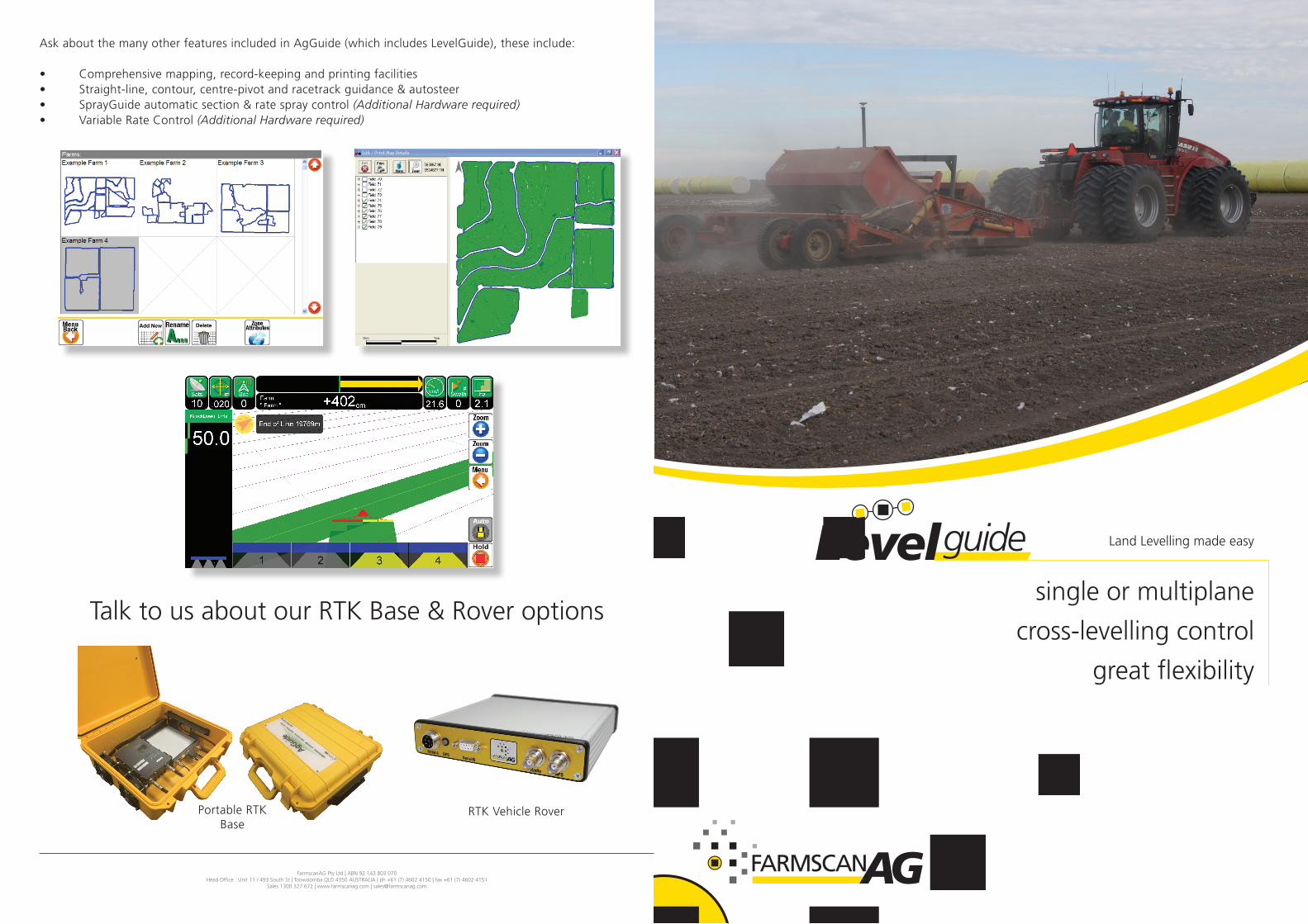
single or multiplane
cross-levelling control
great flexibility
Land Levelling made easy
FarmscanAG Pty Ltd | ABN 92 143 803 070Head Office : Unit 11 / 493 South St | Toowoomba QLD 4350 AUSTRALIA | ph +61 (7) 4602 4150 | fax +61 (7) 4602 4151
Sales 1300 327 672 | www.farmscanag.com | [email protected]
Levelguide
Ask about the many other features included in AgGuide (which includes LevelGuide), these include:
• Comprehensivemapping,record-keepingandprintingfacilities• Straight-line,contour,centre-pivotandracetrackguidance&autosteer• SprayGuideautomaticsection&ratespraycontrol(Additional Hardware required)• VariableRateControl(Additional Hardware required)
TalktousaboutourRTKBase&Roveroptions
Portable RTK Base
RTKVehicleRover
Introducing LevelGuide, Farmscan Ag’s land levelling and contour generation system integrated within the comprehensive AgGuide mapping and guidance software. One program provides the ability to:
• Easilycreatesingleplane,orworkwithmulti-planedesigns• Easilycreatecontourbanks-Cross-levellingcontrol• Recordterrainheightsbeforeandaftereachoperation• Showareascovered,andmaintainjobareasandtimes• Markrunlinesforvisualguidanceorauto-steercapability• Markspecialfeatures• Maintainmultiplefarm,fieldandjobcharacteristicsforfullrecord-keeping
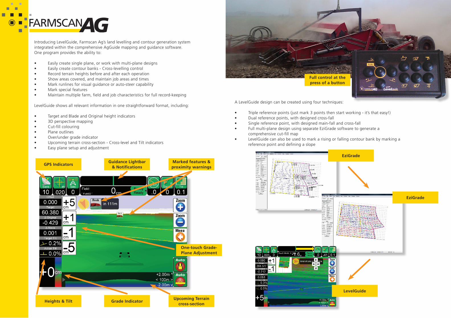
LevelGuide shows all relevant information in one straightforward format, including:
• TargetandBladeandOriginalheightindicators• 3Dperspectivemapping• Cut-fillcolouring• Planeoutlines• Over/undergradeindicator• Upcomingterraincross-section-Cross-levelandTiltindicators• Easyplanesetupandadjustment
A LevelGuide design can be created using four techniques:
• Triplereferencepoints(justmark3pointsthenstartworking-it’sthateasy!)• Dualreferencepoints,withdesignedcross-fall• Singlereferencepoint,withdesignedmain-fallandcross-fall• Fullmulti-planedesignusingseparateEziGradesoftwaretogeneratea comprehensive cut-fill map• LevelGuidecanalsobeusedtomarkarisingorfallingcontourbankbymarkinga reference point and defining a slope
Guidance Lightbar & Notifications
Grade Indicator
GPS Indicators
Heights & Tilt
Marked features & proximity warnings
EziGrade
EziGrade
Full control at the press of a button
LevelGuide
Upcoming Terrain cross-section
One-touch Grade-Plane Adjustment