Embed Size (px)
Citation preview
2
77
1
1
77
2
4
9
3
11
17
78
5051
18
47
5352
17
57
5662
13
4
67
19
6
5
25
62
44
21
57
54
7
64
55
84
70
69
63
27
72
20
40
40
1
4526
71
65
28
22
39
6668
8
63
23
23
73
74
63
29
6
3823 23
25
25
23
23
37
36
35
23
32
75
3075
32
34
76
49
46
48
50
51
23
24
79
33
31
10
10
15 41
58
42
43
5983
58
60
42
17
17
17
82
58
58
84
84
65
66
69
61
16
81
12
14
80
17
17
17
101. Arctic Coastal Plain
102. Arctic Foothills
103. Brooks Range
104. Interior Forested Lowlands
and Uplands
105. Interior Highlands
106. Interior Bottomlands
107. Yukon Flats
108. Ogilvie Mountains
109. Subarctic Coastal Plains
110. Seward Peninsula
111. Ahklun and Kilbuck Mountains
112. Bristol Bay-Nushagak
Lowlands
113. Alaska Peninsula Mountains
114. Aleutian Islands (Western portion
not shown)
115. Cook Inlet
116. Alaska Range
117. Copper Plateau
118. Wrangell Mountains
119. Pacific Coastal Mountains
120. Coastal Western Hemlock-Sitka
Spruce Forests
101
104
103
102
105
106
106
107
108
104
109
110
111
112
113
113
116
117118
119
120
115
114
0 100 200 300 400 Mi
0 200 400 600 Km
Scale 1:16,000,000
Albers Equal Area Projection
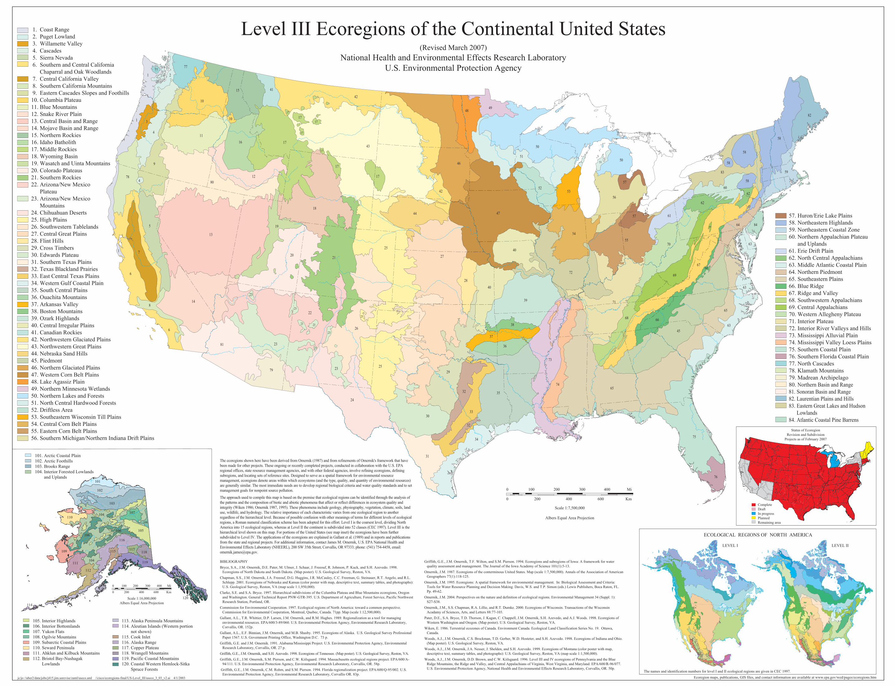
1. Coast Range
2. Puget Lowland
3. Willamette Valley
4. Cascades
5. Sierra Nevada
6. Southern and Central California
Chaparral and Oak Woodlands
7. Central California Valley
8. Southern California Mountains
9. Eastern Cascades Slopes and Foothills
10. Columbia Plateau
11. Blue Mountains
12. Snake River Plain
13. Central Basin and Range
14. Mojave Basin and Range
15. Northern Rockies
16. Idaho Batholith
17. Middle Rockies
18. Wyoming Basin
19. Wasatch and Uinta Mountains
20. Colorado Plateaus
21. Southern Rockies
22. Arizona/New Mexico
Plateau
23. Arizona/New Mexico
Mountains
24. Chihuahuan Deserts
25. High Plains
26. Southwestern Tablelands
27. Central Great Plains
28. Flint Hills
29. Cross Timbers
30. Edwards Plateau
31. Southern Texas Plains
32. Texas Blackland Prairies
33. East Central Texas Plains
34. Western Gulf Coastal Plain
35. South Central Plains
36. Ouachita Mountains
37. Arkansas Valley
38. Boston Mountains
39. Ozark Highlands
40. Central Irregular Plains
41. Canadian Rockies
42. Northwestern Glaciated Plains
43. Northwestern Great Plains
44. Nebraska Sand Hills
45. Piedmont
46. Northern Glaciated Plains
47. Western Corn Belt Plains
48. Lake Agassiz Plain
49. Northern Minnesota Wetlands
50. Northern Lakes and Forests
51. North Central Hardwood Forests
52. Driftless Area
53. Southeastern Wisconsin Till Plains
54. Central Corn Belt Plains
55. Eastern Corn Belt Plains
56. Southern Michigan/Northern Indiana Drift Plains
57. Huron/Erie Lake Plains
58. Northeastern Highlands
59. Northeastern Coastal Zone
60. Northern Appalachian Plateau
and Uplands
61. Erie Drift Plain
62. North Central Appalachians
63. Middle Atlantic Coastal Plain
64. Northern Piedmont
65. Southeastern Plains
66. Blue Ridge
67. Ridge and Valley
68. Southwestern Appalachians
69. Central Appalachians
70. Western Allegheny Plateau
71. Interior Plateau
72. Interior River Valleys and Hills
73. Mississippi Alluvial Plain
74. Mississippi Valley Loess Plains
75. Southern Coastal Plain
76. Southern Florida Coastal Plain
77. North Cascades
78. Klamath Mountains
79. Madrean Archipelago
80. Northern Basin and Range
81. Sonoran Basin and Range
82. Laurentian Plains and Hills
83. Eastern Great Lakes and Hudson
Lowlands
84. Atlantic Coastal Pine Barrens
The ecoregions shown here have been derived from Omernik (1987) and from refinements of Omernik's framework that have
been made for other projects. These ongoing or recently completed projects, conducted in collaboration with the U.S. EPA
regional offices, state resource management agencies, and with other federal agencies, involve refining ecoregions, defining
subregions, and locating sets of reference sites. Designed to serve as a spatial framework for environmental resource
management, ecoregions denote areas within which ecosystems (and the type, quality, and quantity of environmental resources)
are generally similar. The most immediate needs are to develop regional biological criteria and water quality standards and to set
management goals for nonpoint source pollution.
The approach used to compile this map is based on the premise that ecological regions can be identified through the analysis of
the patterns and the composition of biotic and abiotic phenomena that affect or reflect differences in ecosystem quality and
integrity (Wiken 1986; Omernik 1987, 1995). These phenomena include geology, physiography, vegetation, climate, soils, land
use, wildlife, and hydrology. The relative importance of each characteristic varies from one ecological region to another
regardless of the hierarchical level. Because of possible confusion with other meanings of terms for different levels of ecological
regions, a Roman numeral classification scheme has been adopted for this effort. Level I is the coarsest level, dividing North
America into 15 ecological regions, whereas at Level II the continent is subdivided into 52 classes (CEC 1997). Level III is the
hierarchical level shown on this map. For portions of the United States (see map inset) the ecoregions have been further
subdivided to Level IV. The applications of the ecoregions are explained in Gallant et al. (1989) and in reports and publications
from the state and regional projects. For additional information, contact James M. Omernik, U.S. EPA National Health and
Environmental Effects Laboratory (NHEERL), 200 SW 35th Street, Corvallis, OR 97333; phone: (541) 754-4458, email:
BIBLIOGRAPHY
Bryce, S.A., J.M. Omernik, D.E. Pater, M. Ulmer, J. Schaar, J. Freeouf, R. Johnson, P. Kuck, and S.H. Azevedo. 1998.
Ecoregions of North Dakota and South Dakota. (Map poster). U.S. Geological Survey, Reston, VA.
Chapman, S.S., J.M. Omernik, J.A. Freeouf, D.G. Huggins, J.R. McCauley, C.C. Freeman, G. Steinauer, R.T. Angelo, and R.L.
Schlepp. 2001. Ecoregions of Nebraska and Kansas (color poster with map, descriptive text, summary tables, and photographs):
U.S. Geological Survey, Reston, VA (map scale 1:1,950,000).
Clarke, S.E. and S.A. Bryce. 1997. Hierarchical subdivisions of the Columbia Plateau and Blue Mountains ecoregions, Oregon
and Washington. General Technical Report PNW-GTR-395. U.S. Department of Agriculture, Forest Service, Pacific Northwest
Research Station, Portland, OR.
Commission for Environmental Cooperation. 1997. Ecological regions of North America: toward a common perspective.
Commission for Environmental Cooperation, Montreal, Quebec, Canada. 71pp. Map (scale 1:12,500,000).
Gallant, A.L., T.R. Whittier, D.P. Larsen, J.M. Omernik, and R.M. Hughes. 1989. Regionalization as a tool for managing
environmental resources. EPA/600/3-89/060. U.S. Environmental Protection Agency, Environmental Research Laboratory,
Corvallis, OR. 152p.
Gallant, A.L., E.F. Binnian, J.M. Omernik, and M.B. Shasby. 1995. Ecoregions of Alaska. U.S. Geological Survey Professional
Paper 1567. U.S. Government Printing Office, Washington D.C. 73 p.
Griffith, G.E. and J.M. Omernik. 1991. Alabama/Mississippi Project. U.S. Environmental Protection Agency, Environmental
Research Laboratory, Corvallis, OR. 27 p.
Griffith, G.E., J.M. Omernik, and S.H. Azevedo. 1998. Ecoregions of Tennessee. (Map poster). U.S. Geological Survey, Reston, VA.
Griffith, G.E., J.M. Omernik, S.M. Pierson, and C.W. Kiilsgaard. 1994. Massachusetts ecological regions project. EPA/600/A-
94/111. U.S. Environmental Protection Agency, Environmental Research Laboratory, Corvallis, OR. 58p.
Griffith, G.E., J.M. Omernik, C.M. Rohm, and S.M. Pierson. 1994. Florida regionalization project. EPA/600/Q-95/002. U.S.
Environmental Protection Agency, Environmental Research Laboratory, Corvallis OR. 83p.
Griffith, G.E., J.M. Omernik, T.F. Wilton, and S.M. Pierson. 1994. Ecoregions and subregions of Iowa: A framework for water
quality assessment and management. The Journal of the Iowa Academy of Science 101(1):5-13.
Omernik, J.M. 1987. Ecoregions of the conterminous United States. Map (scale 1:7,500,000). Annals of the Association of American
Geographers 77(1):118-125.
Omernik, J.M. 1995. Ecoregions: A spatial framework for environmental management. In: Biological Assessment and Criteria:
Tools for Water Resource Planning and Decision Making. Davis, W.S. and T.P. Simon (eds.) Lewis Publishers, Boca Raton, FL.
Pp. 49-62.
Omernik, J.M. 2004. Perspectives on the nature and definition of ecological regions. Environmental Management 34 (Suppl. 1):
S27-S38.
Omernik, J.M., S.S. Chapman, R.A. Lillie, and R.T. Dumke. 2000. Ecoregions of Wisconsin. Transactions of the Wisconsin
Acadamy of Sciences, Arts, and Letters 88:77-103.
Pater, D.E., S.A. Bryce, T.D. Thorson, J. Kagan, C. Chappell, J.M. Omernik, S.H. Azevedo, and A.J. Woods. 1998. Ecoregions of
Western Washington and Oregon. (Map poster). U.S. Geological Survey, Reston, VA.
Wiken, E. 1986. Terrestrial ecozones of Canada. Environment Canada. Ecological Land Classification Series No. 19. Ottawa,
Canada.
Woods, A.J., J.M. Omernik, C.S. Brockman, T.D. Gerber, W.D. Hosteter, and S.H. Azevedo. 1998. Ecoregions of Indiana and Ohio.
(Map poster). U.S. Geological Survey, Reston, VA.
Woods, A.J., J.M. Omernik, J.A. Nesser, J. Shelden, and S.H. Azevedo. 1999. Ecoregions of Montana (color poster with map,
descriptive text, summary tables, and photographs): U.S. Geological Survey, Reston, VA (map scale 1:1,500,000).
Woods, A.J., J.M. Omernik, D.D. Brown, and C.W. Kiilsgaard. 1996. Level III and IV ecoregions of Pennsylvania and the Blue
Ridge Mountains, the Ridge and Valley, and Central Appalachians of Virginia, West Virginia, and Maryland. EPA/600/R-96/077.
U.S. Environmental Protection Agency, National Health and Environmental Effects Research Laboratory, Corvallis, OR. 50p.
jc/jo //uber2/data/jobs/j415.jim.usrevise/zaml/useco.aml //cisco/ecoregions-final/US-Level_III/useco_3_03_v2.ai 4/1/2003 Ecoregion maps, publications, GIS files, and contact information are available at www.epa.gov/wed/pages/ecoregions.htm
Level III Ecoregions of the Continental United States(Revised March 2007)
National Health and Environmental Effects Research Laboratory
U.S. Environmental Protection Agency
0 100 200 300 400 Mi
0 200 400 600 Km
Scale 1:7,500,000
Albers Equal Area Projection
The names and identification numbers for level I and II ecological regions are given in CEC 1997.
LEVEL II LEVEL I
ECOLOGICAL REGIONS OF NORTH AMERICA
Complete
Draft
In progress
Planned
Remaining area
Status of Ecoregion
Revision and Subdivision
Projects as of February 2007