Embed Size (px)
Citation preview
A Predictive Analysis of Differential Attenuation on Adjacent Satellite Paths Including
Rain Height Effects
JOHN D. KANELLOWULOS, DIONYSIOS MARGETIS Division of Electroscience Department of Electrical and Computer Engineering
National Technical University of Athens 9 Iroon Polytechniou Street, Zografou, GR-15773 Athens - Greece
Abstract. Interference between adjacent Earth-space paths can be caused by propagation effects due to differential rain attenu- ation. In the present paper, a modification of an existing method to predict the rain differential attenuation statistics is pro- posed. The modified method takes into account a more complicated but realistic model for the description of the rain height. The present results are compared with the available simulation data for the differential attenuation over pairs of paths in the Montreal area. The difference between the existing predictive results and the deduced ones after use of the modified proce- dure. for various geographic latitudes and climatic zones, is also examined.
1. INTRODUCTION
An interesting problem in the design of a satellite communication system can arise when two satellites operating at the same frequency are separated from one another by a small angle 8 as viewed from an Earth sta- tion (Fig. 1). Because of the spatial inhomogeneity in the precipitation, periods of time can exist in which the wanted signal may suffer a large attenuation, due to heavy rain while, at the same time, the unwanted signal may experience a much lower attenuation in weaker rain. When this difference in attenuation becomes sufficiently large, then the signal from the adjacent satellite can cause interference. The analysis of the above interference, due to differential rain attenuation between adjacent paths, leads to the consideration of the joint effects of rain attenuation A, of the intended signal and the rain attenua- tion A, of the potential interfering signal. For interference calculations, the conditional distribution of AA = A, - A, under the condition 0.5 dB < A, < M, where M is the maximum allowed attenuation of the wanted signal, should be used. In this sense, Rogers et al [ l ] have first proposed an empirical model for the differential rain attenuation AA at the 1% conditional probability level, valid for the frequency range from 11 to 30 GHz, for ele- vations from 5" to 30". angular separations from 2" to 9", and system margins from 2 to 10 dB. The above model, although simple is provisional and must be used with caution [2]. Further, Kanellopoulos and Houdzoumis [3] suggested a predictive method for the differential attenu-
ation statistics based on a model of convective raincells and the lognormal model for the point rainfall rate statis- tics. More recently, a revised version of this predictive technique has been presented [4] by considering different elevation angles for the two slant paths. It is worthwhile to notice here, that other problems of this type arising in the satellite communication analysis and regarding the differential attenuation interference from an adjacent ter- restrial system, have also been handled by employing the latter technique [5 ,6 ] .
The predictive procedure under discussion, is quite flexible and is oriented to be applicable to any location of the world where the above assumptions are satisfied. A fundamental consideration of the predictive methodology is also concerned with the estimation of the rain height. For this reason, a constant rain height equal to the height of the 0°C isotherm, dependent upon the latitude of the location [7] has been used throughout the analysis there.
Towards this direction, it is our intention to consider here for our interference prediction problem, a more realistic model for the effective rain height suggested by Stutzman and Dishman [8], consisting of using the 0°C isotherm height for low rainrates and adding a rainrate dependent term to the 0°C isotherm height for higher rain- rates. This is consistent with the radar reflectivity profiles given by Goldhirsh and Katz [9], where it is shown that the rain height is equal to the height of the 0°C isotherm for low rainrates. As rainrate increases, the rain height indicated by the reflectivity profiles also increases. This increase is due to the structure of convective raincells in
Vol. 8. No. 2 Much - April 1997 141
Earth Surface Fig. 1 - Configuration of the problem.
which liquid water may be carried well above the 0°C iso- therm level by updrafts. The rain height model under dis- cussion has already been employed [8] for the develop- ment of an effective technique for the estimation of the rain induced attenuation along earth-space paths with very good performance in the important region of low percent- ages of time, compared to experimental data from all over the world. Further, the same novel assumptions for the effective rain height have been used for the analysis of the outage performance of a multiple site diversity Earth- space system [lo]. It is worthwhile to notice here that another consideration for the rain height model has also recently been adopted. Following this consideration, the rain height was assumed to be a random variable uncorre- lated to rainrate, whose median annual value depends on rainrate. This model was applied to a similar problem, that is the prediction of the interference due to hydrometeor scatter on satellite communication links [ 1 I]. However, Olsen et al [12] denote that neither the fixed rain height model nor that of random rain height unconelated to rain- rate seem universally realistic physically.
In the present paper, the modified analysis for the pre- diction of differential rain attenuation is developed, by taking into account the model suggested by Stutzman and Dishman [8] for the rain height. Numerical results taken from the proposed procedure are compared with the only existing set of simulated data from the Montreal area. In addition, the difference between the existing predictive results and the deduced ones due to employment of the novel assumptions for the rain height, for various geo- graphic latitudes and climatic zones, is finally examined.
2. THE ANALYSIS
The analytical configuration of the problem is shown in Fig. 1 . The two satellites have different elevation angles cp,, cp1 and they are separated from one another
by a small angle 0 as viewed from the Earth station. AY is also the projected differential angle between the slant paths under consideration. The description of the parameters He,. He2 and H is given in subsection 2.1. The main point of the interference analysis is the evalu- ation of the differential attenuation statistics given by
P ( A A 2 1-10.5 2 A, 2 M ) =
P(AA 2 r, 0.5 I A,. I M ) P(0.5 I A, I M )
where A, is the attenuation of the desired signal, A, the attenuation of the potential interfering signal, r the exceeded differential attenuation level and M the system margin available for rain attenuation.
2.1. General considerations
The following considerations which are required for the analysis are taken into account.
1) Crane's simplified consideration for the vertical vari- ation of the rainfall structure is first employed [7]. This leads to the assumption of uniform rain structure from the ground up to an effective rain height He. As men- tioned previously, we will consider here the model pro- posed by Stutzman and Dishman [8] for the determina- tion of the rain height H,. According to this considera- tion, the latter parameter is dependent not only on A (geographic latitude of the specific location) but also upon the value of the corresponding point rainfall rate R. As a result, we have
I H, = H for R I l O m m / h
H e = H + l o g ( $ ) for R>lOmm/h
where
H = 4.8 km 1 A 1 530') (3)
It should be noted here that another expression for the mean seasonal value H as a function of A, is also valid [13], but the results are the same. Let us now consider the configuration of the satellite path i (i =1, 2) (Fig. I). We define now two points characteristic for the further analysis: Ai and A,,,, which are the section points of the slant path ES, and the levels H and He,, respectively. The effective rain height He," is evaluated by means of eq. (2 ) and is related to some maximum observed rain- fall rate (say 150 - 200 &). The rain height He varies generally with rain rate and as a direct result the effec- tive slant path length is also a function of the rainrates referring to all points inside the part A; A,ii (Fig. 1) for rainrates between 10 and R, mm/h. The application of
I42 E-fT
the above consideration leads to cumbersome and very complicated calculations but this situation can be avoid- ed by assuming the homogeneity of the rainfall medium inside the part A; A&. Following this assumption the effective lengths of the satellite paths are given by
(4)
where the level Hei depends upon the point rainrate RAi with respect to Ai. This assumption can be shown to be valid for elevation angles greater than about lo", leading to projected straightline parts A; A& of the order of a few kilometers. Moreover, H, is the average height above sea level of the Earth station.
According to the assumption of uniform vertical rain structure, the single and joint exceedance probabilities (eq. (1)) can be obtained as
and c
where
and A;.. A; are the attenuations referring to hypothetical terrestrial links which are the projections of'the slant paths affected by the rain medium, with path lengths
L,, = Ls, cos (pi (i = 1, 2) (8)
2) All the other assumptions are similar to those employed for the analysis of the previous [3, 41 metho- dology using the constant rain height model and they are briefly presented here.
The lognormal form for the unconditional (including non raining time) point rainfall rate R and attenuation A distributions is first adopted.
Next, the specific rain attenuation (in d B h ) is con- sidered to be given by the following expression
where G is a characteristic parameter depending on the spatial structure of the rainfall medium for the specific location.
2.2. Evaluation of the diferentiai attenuation probability
As mentioned previously, the difference of the present contribution with respect to earlier work [3,4] is that this paper attempts at taking into account a more realistic description of the rain height during rain conditions [8]. Since this appears to be the only difference, the expres- sions relating the probabilities (5) and (6) to the lognor- mal statistical parameters A,,, S,, and Am2, S, of the attenuations corresponding to wanted and interfenng sig- nals as well as the logarithmic correlation coefficient p,,,, between them, remain the same. A reference to [3, 41 is considered sufficient. On the other hand, the influence of the novel rain height considerations upon the calculation of the above statistical parameters is very crucial. The evaluation of the A,,, S,, and A,,, S,, in this case can proceed by expressing these parameters as [ 151
in terms of the mean values (pAi) and standard deviations (oAi) of the variables A; and A;, respectively. Following a cumbersome but straightforward analysis the pAi and oAi have been expressed by means of the lognormal statisti- cal parameters R, (median value) and S, (standard devia- tion) of the point rainfall distribution, the constants a and b of the specific attenuation (Ao = aRb) and the charac- teristic distance G (section 2.1), as
( i = 1,2) A o = a R b (9)
where where R is the rainrate and the constants a and b depend upon frequency, incident polarization, temperature and raindrop size distribution.
The convective raincell model proposed by Lin [I41 is finally employed, for the description of the horizontal variation of the rainfall medium. According to this model, the spatial correlation coefficient po (d) of atten- uation gradient A , between two points of the rain medi- um is given by
H- H, L. =- ' tanq,
Vol. 8. Nu. 2 March- April 1997
en (IOIR,,,) u, =
and
3,
where
and the analytical expressions for 1;d and ldd; can be found in [ 101, where the same novel assumptions for the effective rain height have been used for the analysis of the improvement due to the employment of the multiple site diversity technique.
Moreover, the calculation of the pnlr which is the loga- rithmic correlation coefficient between the attenuations 4 and P; follows quite similar steps. Generally, we have [4]
and the path correlation pI2 is expressed as
Following again a similar statistical analysis as before for the pA, and a,, , one gets
E(A: A ; ) = K12 + K i d + K , d + K d d (25)
where
K,, = a2 4 H2 + a2 m i L, h (26)
and the analytical derivation of H 2 can be found else- where [4]. As far as the other terms of (25) ore con- cerned, we have
a* log'e K - Rib . dd - 2 tan 'pI tan (p2
(27)
where
and the analytical expressions for [(L,, L,, A"), I&, S, and K can also be found in [lo].
{>,
3. NUMERICAL RESULTS AND DISCUSSION
In this section, an application of the above analysis for the prediction of the differential attenuation prob- ability, is presented. First, the proposed predictive pro- cedure has been applied to the simulated data for the differential rain attenuation taken from Montreal [ 11. More particularly, forty hours of observations of the three-dimensional radar reflectivity structure of rain in the Montreal area were used to simulate the attenuations occuring simultaneously over a multitude of earth-space propagation paths. It is worthwhile to notice here that the same data base was used in an earlier radar-radiom- eter comparison [ 161, which demonstrated that the attenuation statistics generated synthetically by integrat- ing the measured radar reflectivity over earth-space propagation paths were in good agreement with inde- pendently measured attenuation statistics for the same paths. The compilation of statistics on differential atten- uation on adjacent paths was succeeded by simulating a large number of pairs of paths for a variety of viewing directions, frequencies, elevation angles, angular separ- ations, and taking values of attenuation occuring simul- taneously over the paths computed at 5 min intervals. Further details concerning this matter are given in [ I ] . On the other hand. the implementation of the proposed
procedure requires the knowledge of the parameters H, H,,, a , b, G, R,, and S, with respect io the Montreal data under consideration. A list of appropriate numerical val-
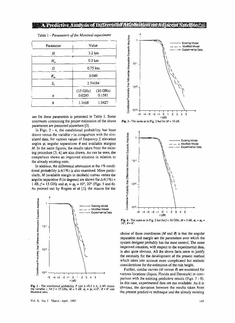
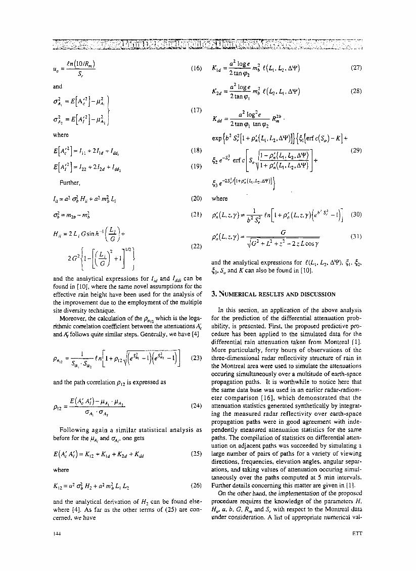
Table 1 - Parameters of the Montreal experiment
Parameter
H
H o
G
Rrn
s r
a
b
I I I Value
3.2 km
0.2 km
0.75 km
0.049
1.74194
(1 5 GHz) (30 GHz) 0.0295 0.1581
1.1418 1.0427
ues for these parameters is presented in Table 1. Some comments concerning the proper estimation of the above parameters are presented elsewhere [3].
In Figs. 2 - 4, the conditional probability has been drawn versus the variable r in comparison with the sim- ulated data, for various values of frequencyf, elevation angles cp, angular separations 0 and available margins M. In the same figures, the results taken from the exist- ing procedure [3,4] are also drawn. As can be seen, the comparison shows an improved situation in relation to the already existing ones.
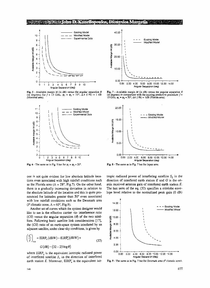
In addition, the differential attenuation at the 1% condi- tional probability AA( 1 %) is also examined. More partic- ularly, M (available margin in decibels) curves versus the angular separation 8 (in degrees) are shown for AA( 1%) = 1 dB,f= 15 GHz and cpl = q+ = lo", 20" (Figs. 5 and 6). As pointed out by Rogers et a1 [l], the reason for the
a t Existing Model
- - - Modified Model - - - Experimental Data
9
Y \
-5 - 4 - 3 - 2 - 1 0 1 2 3 4 5
Fig. 2 - The conditional probability P (AA 2 d0.5 5 A, 5 M) versus the vanable r. f o r f = 15 GHz. M = 5 dB. cpI = cp_ =lo", 8 = 6" and Montreal area.
r (dB)
I Existing Model - - - Modified Model
- - - Experimental Data
5 - 4 - 3 - 2 - 1 0 1 2 3 4 5 r (dB)
Fig. 3 - The same as in Fig. 2 but for M = 10 dB.
Existing Model - - - Modified Model - - - Experimental Data 8
- 5 4 - 3 - 2 - 1 0 1 2 3 4 5 r (dB)
Fig. 4 - The same as in Fig. 2 but forf= 30 GHz, M = 5 dB. cp, = g+ = lo", 8 = 6".
choise of these coordinates (M and 8) is that the angular separation and margin are the parameters over which the system designer probably has the most control. The same improved situation, with respect to the experimental data, is also quite obvious. All the above facts seem to justify the necessity for the development of the present method which takes into account more complicated but realistic considerations for the estimation of the rain height.
Further, similar curves (M versus 0) are examined for various locations (Japan, Florida and Denmark) in com- parison with the existing predictive results (Figs. 7 - 9). In this case, experimental data are not available. As it is obvious, the deviation between the results taken from the present predictive technique and the already existing
Vol. 8. No. 3- March - April 1997 145
10 - Existing Model
I I - - - ModifiedModel
4
- Existing Model - - - Modified Model
---- I *
0 1 2 3 4 5 6 7 8 9 10 Angular Separation (deg)
Fig. 5 - Available margin M (in dB) versus the angular separation 0 ( i n degrees) f o r f = 15 CHz, 'p, = 'pz = lo", A A (1%) = 1 dB (Montreal area).
14.00 -
12.00 - BlO.00 - 9 I .& 8.00 -
6.00 - P 2 4.00 -
A
Fig. 6 - The same as in Fig. 5 but for ql = & = 20"
one is not quite evident for low absolute latitude 1 ca- tions even associated with high rainfall conditions such as the Florida area (A = 28", Fig.7). On the other hand, there is a gradually increasing deviation in relation to the absolute latitude of the location and this is quite pro- nounced for latitudes greater than 50" even associated with low rainfall conditions such as the Denmark area ( F climatic zone, A = 60°, Fig.9).
Another set of curves which the system designer would like to see is the effective carrier -to- interference ratio (C/O versus the angular separation (0) of the two satel- lites. Following basic satellite link considerations [ 171, the (C/O ratio of an earth-space system interfered by an adjacent satellite, under clear-sky conditions, is given by
($) = EIRP, (dBW) - EIRP,'(dBW) + C.S (32)
G(dB)-(32-25log8)
where EIRP, is the equivalent isotropic radiated power of interfered satellite S, in the direction of interfered earth station E. Moreover, EIRP; is the equivalent iso-
I46
40m i - - - Existing Model Modified Model
C I .-
P I \ \ \ . - - - - _ _ - _ - _
0.00 ! * 0.00 2.00 4.00 6.00 8.00 10.00 12.00 14.00
Angular Separation (deg)
Fig. 7 - Available margin M (in dB) versus the angular separation -9 (in degrees) in comparison with the existing predictive procedure: f= 15 GHz, 'p, = = 30". M (1%) = 1dB (Florida area).
2 0 m j I
- - - Wistiq Model - Modified Model - 15.00 % 5 I I
I
0.00 4 0.00 2.00 4.00 6.00 8.00 10.00 12.00 14.00
Angular Separation (deg)
Fig. 8 - The same as in Fig. 7 but for Japan area.
tropic radiated power of interfering satellite S, in th direction of interfered earth station E and G is the on- axis received antenna gain of interfered earth station E. The last term of the eq. (32) specifies a sidelobe enve- lope level relative to the normalized peak gain (0 dB)
- - - Existing Model I - Modified Model I I I I I \ \ \ \ \ \ . . . -
0.00 ! * 0.00 2.00 4.W 6.00 8.00 10.00 12.00 14.00
Angular Separation (deg)
Fig. 9 - The same us in Fig. 7 but for Denmark area ( F climatic zone).
ETT
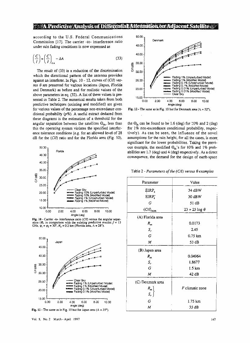
according to the U.S. Federa l Communications Commission [ 171. The carrier -to- interference ratio under rain fading conditions is now expressed as
(33)
The result of (33) is a reduction of the discrimination which the directional pattern of the antenna provides against an interferer. In Figs. 10 - 12, curves of (C/o ver- sus 0 are presented for various locations (Japan, Ronda and Denmark) as before and for realistic values of the above parameters in eq. (32). A list of these values is pre- sented in Table 2. The numerical results taken from both predictive techniques (existing and modified) are given for various values of the percentage non-exceedance con- ditional probability @%). A useful extract deduced from these diagrams is the estimation of a threshold for the angular separation between the satellites Oth, less than this the operating system violates the specified interfer- ence tolerance conditions (e.g. for an allowed level of 28 dB for the (C/O ratio and for the Florida area (Fig. lo),
50"'001 Florida 45.00
40.00
35.00
5 - 30.00 9
25.00
20.00
15.00
Clear Sky -- Fading 10% (Unperturbed Model) - Fading 10% (Modified Model) ..we Fading 1 % (Unperturbed Model) nnao Fading 1 % (Modified Model)
0.00 2.00 4.00 6.00 8.00 10.00 Angle (deg)
Fig. 10 - Carrier -to- interference ratio (C/o versus the angular separ- ation (e), in comparison with the existing predictive results:j= 15 GHz, cp, = = 30". H, = 0.2 km (Florida area, A = 28').
45.00
40.00
- 35.00 3 5 30.00
25.00
20.00
-- Fading 1 % (Unperturbed Model) - Fading 1 % (Modified Model) - Fading 0.1 % (Modified Model) Fading 0.1 % (Unperturbed Model)
15.00 1 0.00 2.00 4.00 6.00 8.00 10.00
Angle (deg) Fig. 11 - The same as in Fig. 10 but for Japan area ( A = 35").
50'00 3 Denmark
45.00
40.00
B - 35.00 30.00
25.00
20.00
-- Fading 1 % (Unperturbed Mode0 - Fading 1 % (Modified Model) en- Fading 0.1% (Unperturbed Model) awee Fading 0.1 % (Modified Model) - Fading 0.01 % (Modified Model) U b h b Fading 0.01 % (Unperturbed Model)
Clear Skv
the 0, can be found to be 1.6 (deg) for 10% and 2 (deg) for 1 % non-exceedance conditional probability, respec- tively). As can be seen, the influence of the novel assumptions for the rain height, for all the cases, is more, significant for the lower probabilities. Taking the previ- ous example, the modified 0,'s for 10% and 1 % prob- abilities are 1.7 (deg) and 4 (deg) respectively. As a direct consequence, the demand for the design of earth-space
Table 2 - Parameters of the (C/I) versus 8 examples
Parameter
EIRP, EIRP,'
G
(C'o"0m
Rln Sr
(A) Florida area
G M
(B) Japan area
R m
Sr
G M
(C) Denmark area
G M
Value
34 dB W 30 dB W 51 dB
23 + 25 log 8
0.0173 2.45
0.75 km 53 dB
0.04964 1.8677 1.5 km 42 dB
F climatic zone
1.75 km 35 dB
Vol. 8. No. 2 March- April 1997
systems less interfered by other adjacent operating satel- lite links leads inevitably to the consideration of more accurate descriptions for the rain height.
As a final remark, we should note that motivation still exists for the further improvement of the analysis, by tak- ing into account the anisotropic behaviour of the spatial rainfall correlation function which is quite significant for several locations around the world [18], or other models (except lognormal), such as a modified gamma form [ 191, for the representation of the point rainfall statistics.
4. CONCLUSIONS
Differential rain attenuation is considered to be one of the main propagation effects on interference between adjacent Earth-space paths. In this paper, a modification of an already existing systematic proce- dure for the prediction of the differential rain attenua- tion, is presented. The modified procedure takes into
account a more complicated but realistic model for the description of the rain height. The results of the pro- posed procedure are compared with simulated data taken from Montreal. The comparison shows an improved situation in relation to the existing method. Moreover, the difference between the existing results and the deduced ones after use of the novel assump- tions for the rain height, for various geographic lati- tudes and climatic zones, is also considered.
It is generally shown that the induced modification is quite significant for problems associated with locations of high absolute latitude even for dry climatic zones. On the other hand, independent of climatic zone and lati- tude of the location, the need for design of earth-space systems suffering least interference problems due to dif- ferential rain attenuation, leads to the inevitable use of more realistic considerations for the rain height.
Manuscript received on May 30, 1995.
REFERENCES
[ I ] R. R. Rogers, R. L. Olsen, I. L. Strickland. G. M. Coulson: Statistics of differential rain attenuation on adjacent Earth- space propagation paths. "Ann. Telecommun.", Vol. 37, No. 11-12. 1982. p. 445-452.
[2] CCIR: P ropagation data required for evaluating interference
Report 885' (MOD I), Doc. 5 (1047-E), Int. Telecommunication Union, 1985, Geneva.
(31 J. D. Kanellopoulos, V. A. Houdzoumis: A model for the predic- tion of differential rain atrenuation on adjacent Earth-space propagation parhs. "Radio Sci.". Vol. 25. No. 5. 1990. p. 853- PCA
lire rain attenuation modeling. "IEEE Tnns. Antennas Prop.", Vol. AP-27. NO. 3, 1979. p. 413-415.
[ 101 J. D. Kanellopoulos. S. N. Livieratos: A modified analysis for the prediction of multiple site diversity performance in ,!Zarth- space communication. "lour of Elec. Waves and Appl. , Vol.
[ 1 I] COST 2 10 Management Committee Commission of European Communities: Influence of the amsphere on intetjkence between radio communications system at frequencies above I CHz. Cat. No CDNA-13407-EN-C, ISBN 92-826-2400-5. 1991, BNSSek.
1121 R. L. Olsen. D. V. Rozers. R. A. Hulavs. M. M. Z. Kharadlv:
between stations in space and those on the surface of the Earth. I I. 1997. p. 483-5 10.
O W .
I. D. Kanellopoulos, S. Ventouras, C. N. Vuzouras: A revised model for the Drediction of differential rain artenuation on adja- cent Ehh-space propag&npaths. "Radio Sci.". Vol. 28. NO. 6. 1993, p. 1071-1086.
J. D. Kanellopoulos, S. Ventouras. S. C. Koukoulas: A model for rhe prediction of the differential rain attenuation between a sat- ellite path and an adjacent terrestrial microwave system based on the two-dimensional gamma distriburion. "lour. of Elec. Waves and Appl.". Vol. 8. No. 5. 1994. p. 557-574.
I. D. Kanellopoulos. C. Sofras: Predictive analysis of the dife- rential rain atrenuation between a satellite path and an a4acent terrestrial microwave system. "Tnns. on the IElCE of Japan",
R. K. Crane: Prediction of attenuation by rain. "IEEE Trans. Commun.". Vol. COM-28, 1980, p. 1717-1733.
Vol. E76-B, NO. 7. 1993, p. 768-776.
W. L. Stutzman, W. K. Dishman: A simple model for the estima- tion of rain-induced attenuation along rorth-space pciths at mil- limeter wavelengths. "Radio Sci.". Vol. 17. No. 6, 1982. p. 1465- 1474.
1. Goldhirsh. I. Katz: Useful e.rperimentrr1 results for earth-scrtel-
-~ Interference due to-Hydrometeor-Scatter on Satelliie Communication Links. "Proc. o f the IEEE". Vol. 81. No. 6. 1993, p. 914-922.
[I31 CCIR: Radiometeorological data. Report 563-2. Int. Telecommunication Union, 1982, Geneva.
[ 141 S. H. Lin: A method for calcularing rain attenuation distribution on microwave paths. "Bell Syst. Tech. J.", Vol. 54. No. 6, 1975,
[ 151 A. Papoulis: Probability, Random Variables and Stochastic Processes. Mc Craw-Hill, 1965. New York.
[ 161 R. R. Rogers, S. Radhakant. 0. Massambani: New radar studies of slant-path attenuarion due to rain. "Ann. Telecommun.", Vol.
[I71 T. T. Ha: Digital satellite communications. Mac Millan, 1986, New York.
[I81 D. C. Hogg. T. S. Chu: The role of rain in satellite communica- tions. "Proc. IEEE. Vol. 63. No. 9. 1975. p. 1308-1331.
1191 F. Mouofouma: Model of rtiinfnll-rote distribution for radio
p. 1051-1086.
36. NO. 1-2, 1981. p. 40-47.
. . system design. "Roc. Inst: Eleck. Eng. Part H", Vol. 132. NO. I . 1985. p. 39-43.