Embed Size (px)
Citation preview
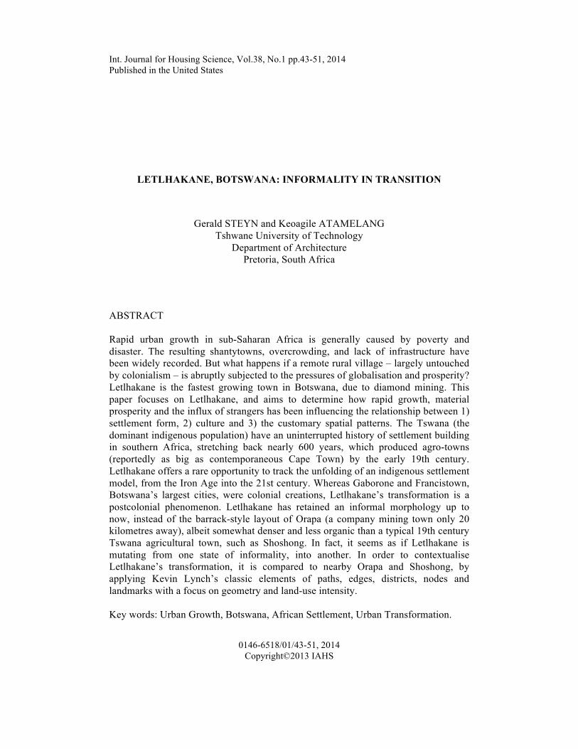
Int. Journal for Housing Science, Vol.38, No.1 pp.43-51, 2014 Published in the United States
0146-6518/01/43-51, 2014 Copyright©2013 IAHS
LETLHAKANE, BOTSWANA: INFORMALITY IN TRANSITION
Gerald STEYN and Keoagile ATAMELANG Tshwane University of Technology
Department of Architecture Pretoria, South Africa
ABSTRACT Rapid urban growth in sub-Saharan Africa is generally caused by poverty and disaster. The resulting shantytowns, overcrowding, and lack of infrastructure have been widely recorded. But what happens if a remote rural village – largely untouched by colonialism – is abruptly subjected to the pressures of globalisation and prosperity? Letlhakane is the fastest growing town in Botswana, due to diamond mining. This paper focuses on Letlhakane, and aims to determine how rapid growth, material prosperity and the influx of strangers has been influencing the relationship between 1) settlement form, 2) culture and 3) the customary spatial patterns. The Tswana (the dominant indigenous population) have an uninterrupted history of settlement building in southern Africa, stretching back nearly 600 years, which produced agro-towns (reportedly as big as contemporaneous Cape Town) by the early 19th century. Letlhakane offers a rare opportunity to track the unfolding of an indigenous settlement model, from the Iron Age into the 21st century. Whereas Gaborone and Francistown, Botswana’s largest cities, were colonial creations, Letlhakane’s transformation is a postcolonial phenomenon. Letlhakane has retained an informal morphology up to now, instead of the barrack-style layout of Orapa (a company mining town only 20 kilometres away), albeit somewhat denser and less organic than a typical 19th century Tswana agricultural town, such as Shoshong. In fact, it seems as if Letlhakane is mutating from one state of informality, into another. In order to contextualise Letlhakane’s transformation, it is compared to nearby Orapa and Shoshong, by applying Kevin Lynch’s classic elements of paths, edges, districts, nodes and landmarks with a focus on geometry and land-use intensity. Key words: Urban Growth, Botswana, African Settlement, Urban Transformation.
44 Steyn And Atamelang
Introduction When Botswana became independent from Britain in 1966, it was one of the poorest countries in the world. However, since the discovery of diamonds just a year later, Botswana has emerged as the largest producer of diamonds, in the world, with one of the highest economic growth rates. Letlhakane was a quiet, traditional rural village consisting primarily of thatched round huts with mud walls. But, due to its locality within 15-20 kilometres of the three biggest diamond mines (operated by Debswana, a joint venture between De Beers and the Botswana government), it soon evolved as the fastest growing town in Botswana. The recent nearby discovery of one of the largest uranium deposits in the world, is assuring Letlhakane’s prosperity well into the future. The apparently organic and informal layouts of the traditional Tswana village, including those in the 19th century, are deceiving. The forms of these towns were based on a precise conceptual model, reflecting the cultural construct (botho in Setswana) with its rules of precedence, demarcation of gender roles and conventions of social interaction, as well as the centrality of cattle. Internal conflict and the expansion of white settlers, obliterated these traditional villages in present-day South Africa. But, in the British Protectorate of Bechuanaland, established in 1885, these villages continue to exist even to this day – in some instances they flourished. Botho is a particularly resilient, complex and encompassing culture, evolving in time and space by responding to climate, geo-political threats and opportunities, and availability of resources. The traditional ethics and social norms remain intrinsic characteristics of social behaviour throughout Botswana, and so do the spatial patterns in rural villages such as Mochudi, Gabane and Shoshong. Shantytowns and slums are visible demonstrations of what African people can achieve without official intervention or sanction, and so the terms ‘informal settlement’ and ‘informality’ have over time become associated with all bottom-up, self-help products and processes. However, Letlhakane is neither a shantytown nor a slum, but rather the culmination of a very long evolution of residential and urban patterns.
Origins Letlhakane is situated in Central Botswana, and only evolved as a village in 1939 because it offered water for crop production and good grazing for cattle, while other parts were suffering from a severe drought. The mines have affected Letlhakane village in many ways, both positive and negative. Until the discovery of diamonds, the morphology of the village was similar to that of Shoshong and many other current traditional villages in Botswana. A number of dwellings (malapa), usually belonging to related families, were clustered in a horseshoe-shaped layout around a cattle kraal and a ‘kgotla’ (traditional meeting place), constituting a ward (dikgoro). The ‘dikgoro’ is an ancient institution and has social, physical and spatial implications. Houses were mostly round huts, called ‘ntlo’ (the house of a wife or married woman), constructed of daga (a mixture of mud and cow dung) with thatched roofs, and were
Informality in Transition 45
mainly built by women. Open courtyards (lolwapa) were the true living spaces. In the 1940s, even the school had daga walls and thatched roofs [1]. Cattle are still central to Tswana culture. They signify wealth, but also serve as bride wealth (bogadi), compensation for damages, and are given as presents to show gratitude (or influence people). Cattle are slaughtered at funerals, weddings, birthdays and most celebrations [2]. When the mines started their operations in the early 1970s, many people migrated to Letlhakane in the hope of finding employment. The population expanded rapidly, and that had a number of profound and interlinked impacts on the morphology. First, homeowners quickly recognised a lucrative rental market and built small backyard rooms on their properties, to accommodated single men and small families. Second, due to the increase and densification of people, the livestock that was kept within the settlement was moved away from the village. This changed the village in two ways. Traditional mud houses now became difficult to construct, because cow dung was not readily available. The locals were subsequently introduced to a new and different way of house construction; concrete masonry blocks and metal roof sheeting. Such houses were built by specialised and commercialised craftsmen working in teams, and not by women anymore. Land concessions granted to the mines, restricted the territorial expansion of the village. With the cattle kraals gone, the open space defined by the horseshoe pattern was quickly filled in with dwelling plots, in most cases also offering backyard accommodation. However, the layout clearly remains organic and informal. Orapa, just 27km from Letlhakane, is the quintessential ‘new town’. It was built from scratch after the discovery of diamonds. It is surrounded by security fences, and with strict access control only residents and visitors with permits are allowed in. Most residents seem to enjoy the safety and security and the high level of services and amenities. The town offers excellent facilities to its residents, who include a high proportion of expatriates. Facilities include schools for employees' children, a 100-bed hospital, clinics, restaurants and sports clubs. An airport serves Debswana aircraft. A 22 000 hectare game park is intended for recreation, education, conservation and the promotion of biodiversity [3]. Shoshong is situated 234km from Letlhakane by road. It was founded in the early 1840s, by the Ngwato as their new capital, after they had fled under pressure from Mzilikazi’s raiders, from their previous lands further east. At one stage Shoshong had a population of approximately 30 000 (including several European missionaries and traders), which (because of a severe drought) shrunk to only 6 000 in 1889. The town recovered very slowly, but remains a ‘stronghold of Tswana traditionalism’ [4]. It retains the horseshoe-shaped homestead pattern.
Infrastructure and Amenities Some inhabitants are complaining that Debswana neglected Letlhakane. Orapa, similar to most company towns, probably has better quality facilities, but Letlhakane is unquestionably well resourced when compared with Shoshong and most other
46 Steyn And Atamelang
traditional villages. It has five primary schools, two junior secondary schools, one senior secondary school and one private senior secondary school, all in good condition. Annual scholarships provided by Debswana, are available for higher education at the University of Botswana, and others outside the country. The village has a new and well constructed tarred road network, a reliable public transport system and a police station, all of which are under the administration of the sub-district council. The incidence of crime is low. The inhabitants have access to free health care at one medium-sized hospital and two clinics, funded by the government and the mining companies. Letlhakane has no public areas like parks, but the locals use school sports grounds for 'Sunday soccer', an activity that is slowly becoming a custom. There are a few pubs and taverns in the village. Taxi cabs are mainly used as public transport, while mini buses and coaches are used for long distances. Donkey carts are still used by the locals who cannot afford cars. Whereas people lived simple, quiet and apparently quite comfortable lives of agriculture and animal production, they are now confronted with all the accoutrements of contemporary capitalism-based consumerism. The mines have been attracting investors, developers and entrepreneurs. There are vehicle service stations, reputable supermarkets and stores, and a number of international banks. There is even a local shoe manufacturing company, and a number of small concrete block producers.
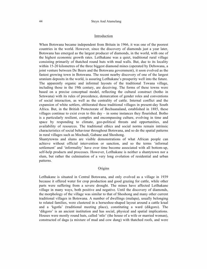
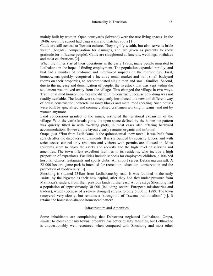
Comparing the Numbers Figure 1 shows that Letlhakane has a bigger footprint than Orapa and Shoshong, but it also has a significantly larger population. The graphs in Figure 2 reveal some of the dynamics. Shoshong, largely able to maintain its agro-town economy, grew steadily at a consistent rate. Orapa, with its capacity dictated by the human resources required by the mines, expanded rapidly until it could accommodate the planned number of people. It then maintained a constant population level. The population of Letlhakane initially grew just as fast as that of Orapa, but while Orapa had reached its intended limit of growth, Letlhakane continued to grow rapidly [5].
Form and Fabric
Letlhakane is a linear form of settlement due to its locality along the now-dry river channel. The traditional Tswana residential model is a compound, often housing several closely related family groups. Until the 1990s, much of the urban housing followed the traditional pattern of separate round huts surrounding a courtyard. This is becoming increasingly rare. Because most huts are single-room structures rarely exceeding a six metre diameter, the scale is small and the fabric homogeneous. The rectangular cement block structures that are now becoming prevalent, retain the single-cell pattern, especially for rental accommodation, which now crowds many yards. The result is that both the small scale of the fabric and its uniformity are
Informality in Transition 47
retained. Regrettably, the influx of outsiders and the increasing number of Western style houses, result in the disappearance of both the ‘kgotla’ as a formal meeting place, and the ‘lolwapa’, which promotes interaction between family members living in the same compound. However, the lucrative business of letting has lead to the creation of small outdoor interaction spaces.
FIG 1. Town plans compared (drawing by the Author).
FIG 2. Population growth comparison (source: CSO 2012). Government and some private companies provide some housing. Plan forms are rectangular and features all spatial functions under one roof, the quintessential European residential model. A significant number of locals are also building such freestanding suburban houses for themselves.
48 Steyn And Atamelang
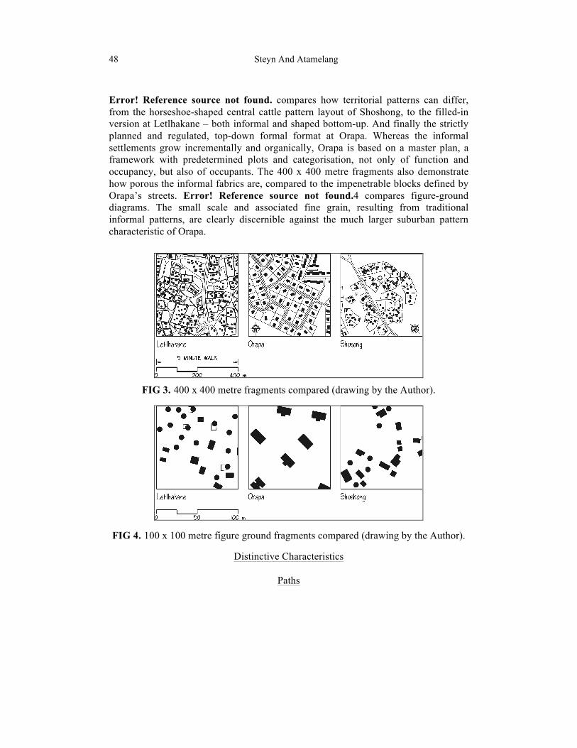
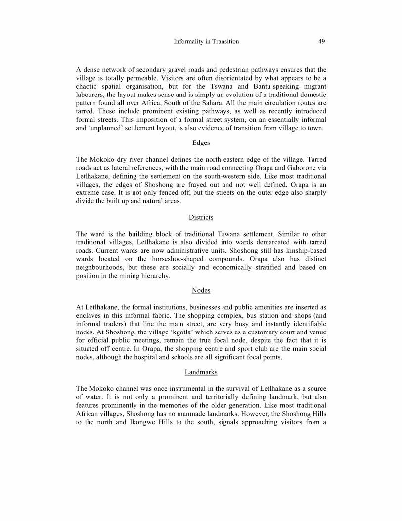
Error! Reference source not found. compares how territorial patterns can differ, from the horseshoe-shaped central cattle pattern layout of Shoshong, to the filled-in version at Letlhakane – both informal and shaped bottom-up. And finally the strictly planned and regulated, top-down formal format at Orapa. Whereas the informal settlements grow incrementally and organically, Orapa is based on a master plan, a framework with predetermined plots and categorisation, not only of function and occupancy, but also of occupants. The 400 x 400 metre fragments also demonstrate how porous the informal fabrics are, compared to the impenetrable blocks defined by Orapa’s streets. Error! Reference source not found.4 compares figure-ground diagrams. The small scale and associated fine grain, resulting from traditional informal patterns, are clearly discernible against the much larger suburban pattern characteristic of Orapa.
FIG 3. 400 x 400 metre fragments compared (drawing by the Author).
FIG 4. 100 x 100 metre figure ground fragments compared (drawing by the Author).
Distinctive Characteristics
Paths
Informality in Transition 49
A dense network of secondary gravel roads and pedestrian pathways ensures that the village is totally permeable. Visitors are often disorientated by what appears to be a chaotic spatial organisation, but for the Tswana and Bantu-speaking migrant labourers, the layout makes sense and is simply an evolution of a traditional domestic pattern found all over Africa, South of the Sahara. All the main circulation routes are tarred. These include prominent existing pathways, as well as recently introduced formal streets. This imposition of a formal street system, on an essentially informal and ‘unplanned’ settlement layout, is also evidence of transition from village to town.
Edges The Mokoko dry river channel defines the north-eastern edge of the village. Tarred roads act as lateral references, with the main road connecting Orapa and Gaborone via Letlhakane, defining the settlement on the south-western side. Like most traditional villages, the edges of Shoshong are frayed out and not well defined. Orapa is an extreme case. It is not only fenced off, but the streets on the outer edge also sharply divide the built up and natural areas.
Districts The ward is the building block of traditional Tswana settlement. Similar to other traditional villages, Letlhakane is also divided into wards demarcated with tarred roads. Current wards are now administrative units. Shoshong still has kinship-based wards located on the horseshoe-shaped compounds. Orapa also has distinct neighbourhoods, but these are socially and economically stratified and based on position in the mining hierarchy.
Nodes At Letlhakane, the formal institutions, businesses and public amenities are inserted as enclaves in this informal fabric. The shopping complex, bus station and shops (and informal traders) that line the main street, are very busy and instantly identifiable nodes. At Shoshong, the village ‘kgotla’ which serves as a customary court and venue for official public meetings, remain the true focal node, despite the fact that it is situated off centre. In Orapa, the shopping centre and sport club are the main social nodes, although the hospital and schools are all significant focal points.
Landmarks The Mokoko channel was once instrumental in the survival of Letlhakane as a source of water. It is not only a prominent and territorially defining landmark, but also features prominently in the memories of the older generation. Like most traditional African villages, Shoshong has no manmade landmarks. However, the Shoshong Hills to the north and Ikongwe Hills to the south, signals approaching visitors from a
50 Steyn And Atamelang
considerable distance. So do the multi-storey FISH (Fully Integrated Sort House) and the CARP (Completely Automated Recovery Plant) at Orapa.
Conclusion The traditional Setswana culture is called ‘botho’. ‘Botho’ is based on rules of precedence, the demarcation of gender roles, and conventions of social interaction. Loosely translated, ‘botho’ means a ‘person is a person through other people’. This concept emphasises the obligations of the individual towards the community. Botho is also entrenched as a fundamental principle in Botswana’s strategy for the future, called Vision 2016. The tenets of ‘botho’, like those of all cultures, have been dictating the form and spatial organisation of the traditional Tswana homestead and village. The relationship between the kgosi’s dwelling, the cattle kraal and ‘kgotla’, and the relationship between this central byre and the associated dwellings, and then the relationship between the huts and their ‘lolwapa’, have all been culturally entrenched. Finally, the relationship between the ‘kgosing’ (the chief’s compound) and the other compounds that make up the village, are just as codified. The first Tswana agro-towns were circular and elliptical patterns, with houses fully encircling the centre ‘kgotla’ and kraal. All construction was circular or curvilinear. Straight lines and rectangles were introduced only after exposure to early missionaries, defining both the territorial boundaries of individual dwellings within the horseshoe-shaped ensemble, and the geometry of the ‘lolwapa’. Interestingly, the ‘kgotla’ remained circular, and remains so in many places, to this day. When the focus of the ward-compound (the cattle kraal) was removed and the open space claimed for occupation, the pattern changed again. With rectangular rental rooms and Western-style freestanding houses now increasingly popular, another form of informality is clearly evolving. Shoshong will probably face similar challenges to those of Letlhakane, because of the discovery of significant uranium deposits near Shoshong, in 2010. With the ‘kgotla’ and cattle kraals gone, it is not surprising that older inhabitants complain that development and the influx of strangers have diluted the cultural and spatial order of Letlhakane. They lament that the youth of today cannot even explain the purpose of the ‘kgotla’, or the construction methods behind a typical mud hut. The sceptics must realise, however, that form and spatial organisation is the product of the complex interaction between social, cultural, economic and physical factors. Before the discovery of diamonds, Letlhakane was shaped by strict farming rules and the need for collective action in times of drought and scarcity. The motive was survival. Currently the need to accommodate and service migrant workers, provides an economically mutually beneficial arrangement. Most of the basic traits and spatial concepts of the Tswana settlement pattern are gradually vanishing, but they are being replaced by another pattern, one that remains in the spirit of ‘botho’, responsive to the welfare of the community.
Informality in Transition 51
References
[1] Zowa Development Trust. 2012. Challenges in Our Community, <http://zowadevelopmenttrust.wordpress.com/history-of-zowa> (accessed 20 Jan 2013).
[2] Denbow, J. and Thebe, P. – Culture and Customs of Botswana. Westport, Connecticut: Greenwood, 2006.
[3] De Beers. 2012. Orapa, (accessed 23 January 2013). <https://www.debeersgroup.com/Operations/Mining/Mining-Operations/Debswana/Orapa>
[4] Reid, A.; Lane, P.; Segobye, A.; Borjeson, L.; Mathibidi,N.; Sekgarametso, P. – Tswana Architecture and Responses to Colonialism, in World Archaeology. Vol. 28, No.3, (1997), pp.370-392.
[5] Central Statistics Office (CSO), Republic of Botswana, 2012, Population stats 1991, 2001, 2011, <http://www.citypopulation.de/Botswana.html> (accessed 10 Dec 2012).