Embed Size (px)
Citation preview
This material is based upon work supported by the National Aeronautics and Space Administration under Grant/Contract/Agreement No. NNX10AB51A issued through the Global Climate Change Education (GCCE): Research Experiences, Teaching and Learning.
Copyright© Challenger Center for Space Science Education
1
Lesson: Mt. Pinatubo and the Lithosphere
STUDENT WORKSHEET | Mt. Pinatubo 1991: The Blast Heard ‘Round the World
BackgroundMost days, the Philippine island of Luzon is a center of activity. It is home to the country’s capital and major businesses. On April 2, 1991, however, things were different. All of the usual activity of the island—the market, busy streets, and farmers hard at work—was nothing compared to the activity taking place underneath the land. One of the world’s most active volcanoes, Mt. Pinatubo, had decided to wake, alerting the two local United States Air Force bases, and drawing U.S. geologists to the scene.
Volcanologists from the Philippines and the United States worked together. It took them ten weeks to successfully forecast what would happen. In situations like these, the scientists examine the data to decide which of three possibilities is the most likely to occur. In the first possibility, the volcano might show signs of tectonic plates sliding back and forth across each other. This could result in earthquakes, but not volcanic eruptions. In the second possibility, the volcano could be venting a build-up of underground gases that have accumulated over many years. In this situation, the pressure from the gases is released and then the volcano settles back down. In the third possibility, scientists are looking for signs of a major explosive eruption — the kind that is quick and disastrous. This last possibility was the most consistent with the past history of the volcano, which showed that Mt. Pinatubo had perhaps hundreds of major explosions over the centuries.
Collecting data from a live volcano is dangerous work. When you think of dangerous jobs, a geologist is probably not what comes to mind. Nonetheless, many scientists have been killed while studying volcanoes. Back in 1991, seismometers were placed in key areas to record the underground activity. The data from the equipment had to be collected, oftentimes daily, by driving and hiking to each unit.
Image courtesy United States Geological Surveyhttp://vulcan.wr.usgs.gov/Volcanoes/Philippines/Pinatubo/images.html
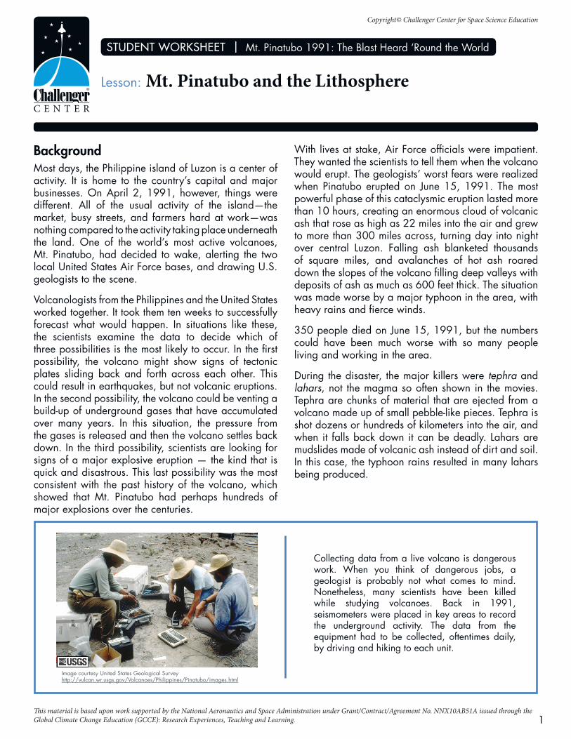
With lives at stake, Air Force officials were impatient. They wanted the scientists to tell them when the volcano would erupt. The geologists’ worst fears were realized when Pinatubo erupted on June 15, 1991. The most powerful phase of this cataclysmic eruption lasted more than 10 hours, creating an enormous cloud of volcanic ash that rose as high as 22 miles into the air and grew to more than 300 miles across, turning day into night over central Luzon. Falling ash blanketed thousands of square miles, and avalanches of hot ash roared down the slopes of the volcano filling deep valleys with deposits of ash as much as 600 feet thick. The situation was made worse by a major typhoon in the area, with heavy rains and fierce winds.
350 people died on June 15, 1991, but the numbers could have been much worse with so many people living and working in the area.
During the disaster, the major killers were tephra and lahars, not the magma so often shown in the movies. Tephra are chunks of material that are ejected from a volcano made up of small pebble-like pieces. Tephra is shot dozens or hundreds of kilometers into the air, and when it falls back down it can be deadly. Lahars are mudslides made of volcanic ash instead of dirt and soil. In this case, the typhoon rains resulted in many lahars being produced.
Copyright© Challenger Center for Space Science Education
STUDENT WORKSHEET | Mt. Pinatubo and the Lithosphere
2
Images courtesy United States Geological Surveyhttp://vulcan.wr.usgs.gov/Volcanoes/Philippines/Pinatubo/images.html
Review1. Geologists were looking for three possible causes for the earthquakes. What were the three causes and the
possible consequences of each?
2. What did they find to be the real problem with the mountain?
3. Which were the two primary killers from the eruption?
4. Describe the types of risks that volcanologists might take to help protect property and save lives.
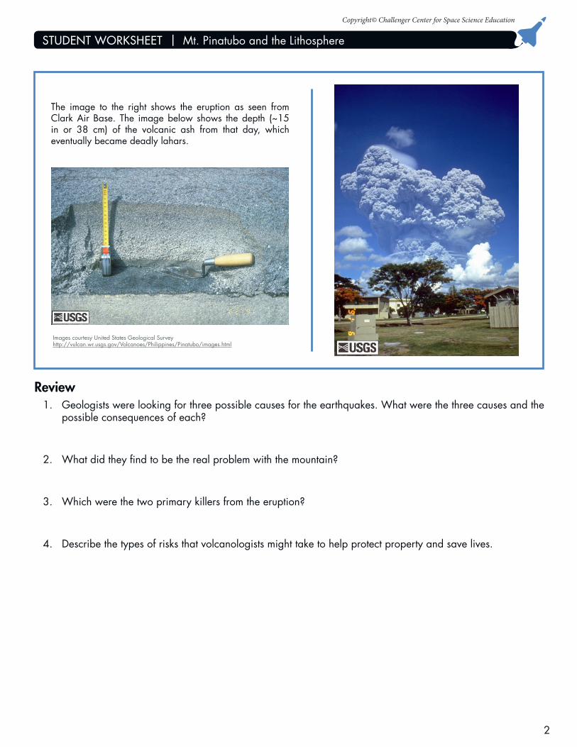
The image to the right shows the eruption as seen from Clark Air Base. The image below shows the depth (~15 in or 38 cm) of the volcanic ash from that day, which eventually became deadly lahars.
Copyright© Challenger Center for Space Science Education
STUDENT WORKSHEET | Mt. Pinatubo and the Lithosphere
3
Name:___________________________________________ Date:______________________
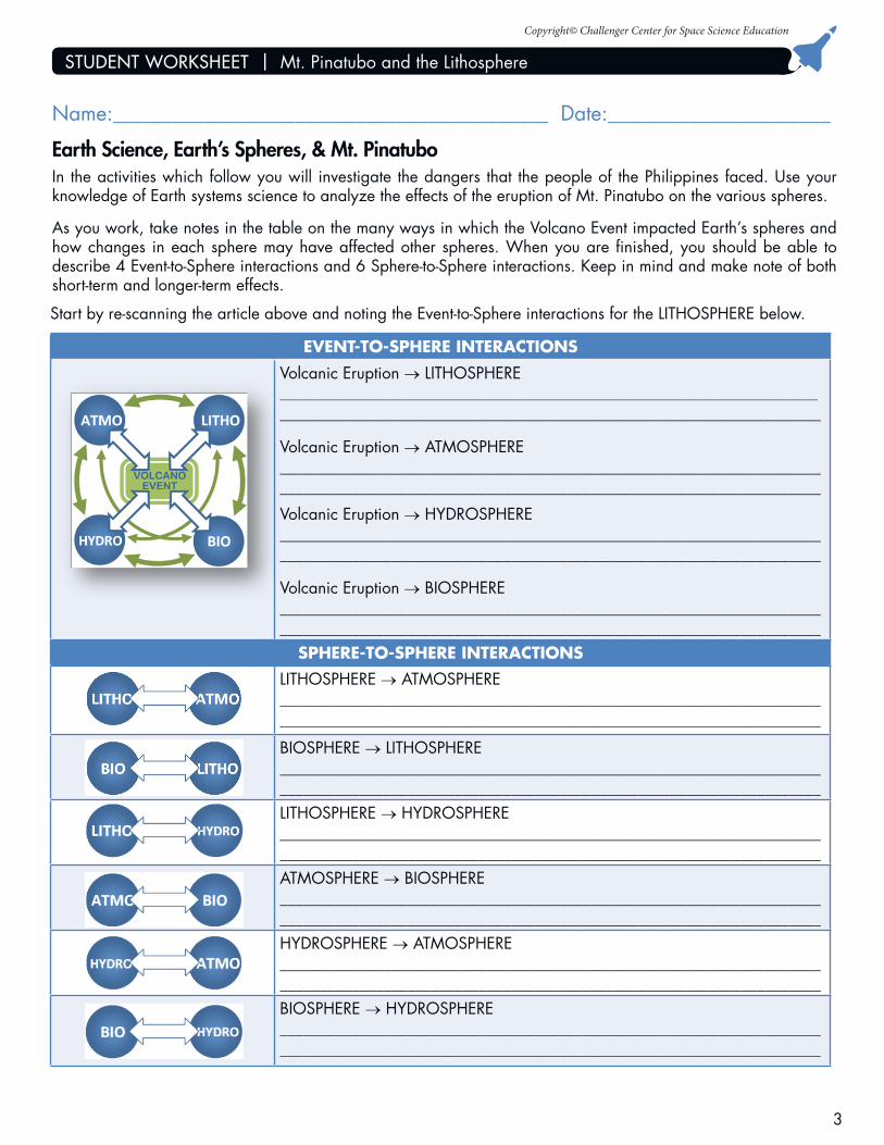
Earth Science, Earth’s Spheres, & Mt. PinatuboIn the activities which follow you will investigate the dangers that the people of the Philippines faced. Use your knowledge of Earth systems science to analyze the effects of the eruption of Mt. Pinatubo on the various spheres.
As you work, take notes in the table on the many ways in which the Volcano Event impacted Earth’s spheres and how changes in each sphere may have affected other spheres. When you are finished, you should be able to describe 4 Event-to-Sphere interactions and 6 Sphere-to-Sphere interactions. Keep in mind and make note of both short-term and longer-term effects.
Start by re-scanning the article above and noting the Event-to-Sphere interactions for the LITHOSPHERE below.
EVENT-TO-SPHERE INTERACTIONS
Volcanic Eruption → LITHOSPHERE_____________________________________________________________________________________________
____________________________________________________________________
Volcanic Eruption → ATMOSPHERE____________________________________________________________________ ____________________________________________________________________
Volcanic Eruption → HYDROSPHERE____________________________________________________________________ ____________________________________________________________________
Volcanic Eruption → BIOSPHERE____________________________________________________________________ ____________________________________________________________________
SPHERE-TO-SPHERE INTERACTIONS
LITHOSPHERE → ATMOSPHERE____________________________________________________________________ ____________________________________________________________________
BIOSPHERE → LITHOSPHERE____________________________________________________________________ ____________________________________________________________________LITHOSPHERE → HYDROSPHERE____________________________________________________________________ ____________________________________________________________________ATMOSPHERE → BIOSPHERE____________________________________________________________________ ____________________________________________________________________HYDROSPHERE → ATMOSPHERE____________________________________________________________________ ____________________________________________________________________BIOSPHERE → HYDROSPHERE____________________________________________________________________ ____________________________________________________________________
Copyright© Challenger Center for Space Science Education
STUDENT WORKSHEET | Mt. Pinatubo and the Lithosphere
4
Volcanoes: Constructive Or Destructive?Volcanoes have been erupting on Earth since its creation. Evidence shows they have erupted on other planets and moons in our solar system as well. They are most unpredictable. For hundreds of years volcanic mountains sit quietly—regal backdrops for the people who live in their shadows. Then they come alive, perhaps spewing only small amounts of ash, steam, and gas into the atmosphere; perhaps erupting in great violence.
A volcano is an opening or a crack in the surface of the earth from which pours gases, steam, molten rock, and rock debris. As pressure builds under the surface, a volcano works as a giant vent—allowing these pent-up, super-hot materials to escape to the surface. Over many years, this oozy and rocky material accumulates around this vent. It becomes taller and taller resulting in the classic volcano shape.
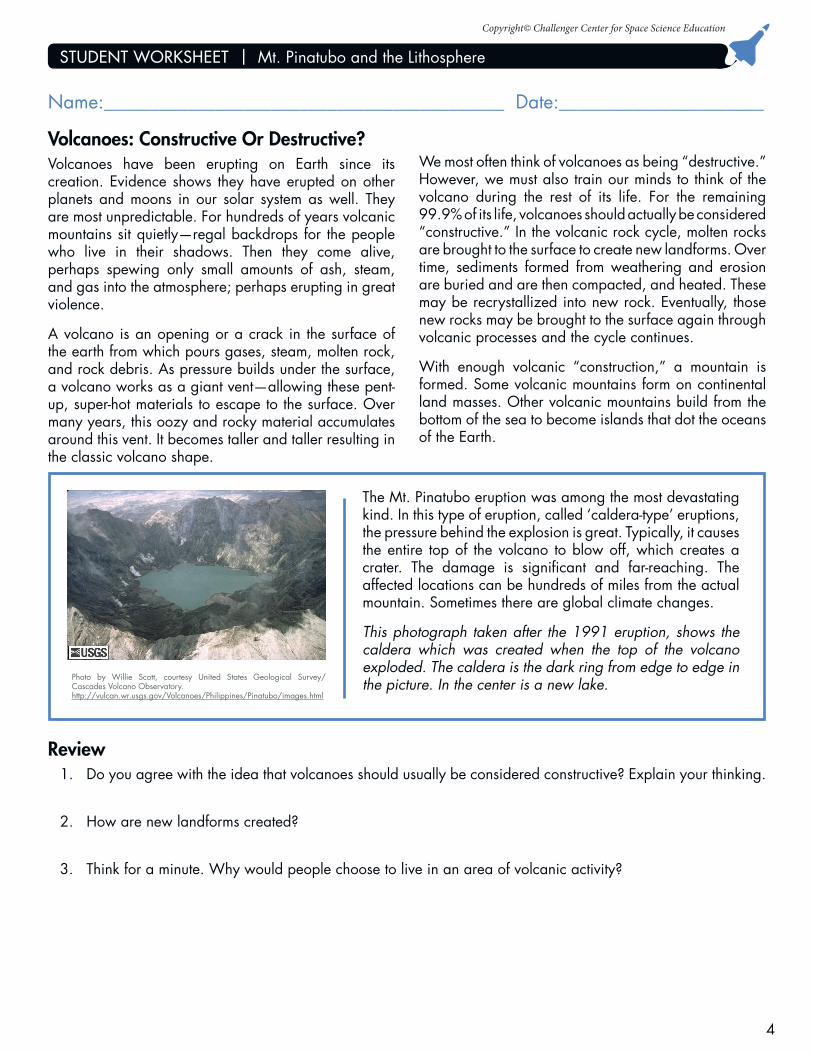
The Mt. Pinatubo eruption was among the most devastating kind. In this type of eruption, called ‘caldera-type’ eruptions, the pressure behind the explosion is great. Typically, it causes the entire top of the volcano to blow off, which creates a crater. The damage is significant and far-reaching. The affected locations can be hundreds of miles from the actual mountain. Sometimes there are global climate changes.
This photograph taken after the 1991 eruption, shows the caldera which was created when the top of the volcano exploded. The caldera is the dark ring from edge to edge in the picture. In the center is a new lake.
We most often think of volcanoes as being “destructive.” However, we must also train our minds to think of the volcano during the rest of its life. For the remaining 99.9% of its life, volcanoes should actually be considered “constructive.” In the volcanic rock cycle, molten rocks are brought to the surface to create new landforms. Over time, sediments formed from weathering and erosion are buried and are then compacted, and heated. These may be recrystallized into new rock. Eventually, those new rocks may be brought to the surface again through volcanic processes and the cycle continues.
With enough volcanic “construction,” a mountain is formed. Some volcanic mountains form on continental land masses. Other volcanic mountains build from the bottom of the sea to become islands that dot the oceans of the Earth.
Photo by Willie Scott, courtesy United States Geological Survey/ Cascades Volcano Observatory.http://vulcan.wr.usgs.gov/Volcanoes/Philippines/Pinatubo/images.html
Review1. Do you agree with the idea that volcanoes should usually be considered constructive? Explain your thinking.
2. How are new landforms created?
3. Think for a minute. Why would people choose to live in an area of volcanic activity?
Name:___________________________________________ Date:______________________
Copyright© Challenger Center for Space Science Education
STUDENT WORKSHEET | Mt. Pinatubo and the Lithosphere
5
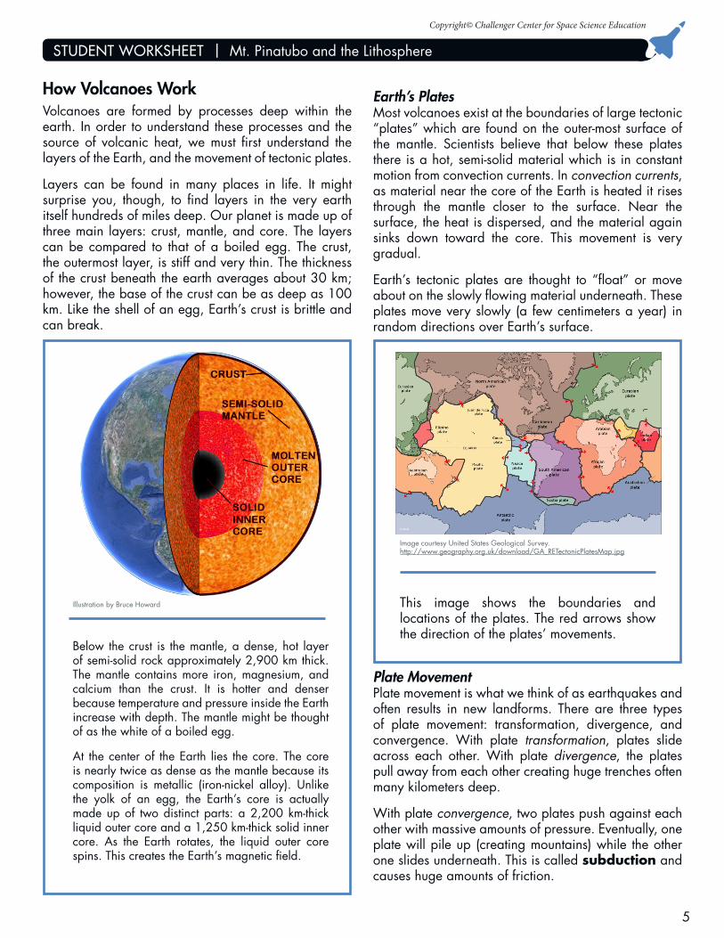
How Volcanoes WorkVolcanoes are formed by processes deep within the earth. In order to understand these processes and the source of volcanic heat, we must first understand the layers of the Earth, and the movement of tectonic plates.
Layers can be found in many places in life. It might surprise you, though, to find layers in the very earth itself hundreds of miles deep. Our planet is made up of three main layers: crust, mantle, and core. The layers can be compared to that of a boiled egg. The crust, the outermost layer, is stiff and very thin. The thickness of the crust beneath the earth averages about 30 km; however, the base of the crust can be as deep as 100 km. Like the shell of an egg, Earth’s crust is brittle and can break.
Earth’s PlatesMost volcanoes exist at the boundaries of large tectonic “plates” which are found on the outer-most surface of the mantle. Scientists believe that below these plates there is a hot, semi-solid material which is in constant motion from convection currents. In convection currents, as material near the core of the Earth is heated it rises through the mantle closer to the surface. Near the surface, the heat is dispersed, and the material again sinks down toward the core. This movement is very gradual.
Earth’s tectonic plates are thought to “float” or move about on the slowly flowing material underneath. These plates move very slowly (a few centimeters a year) in random directions over Earth’s surface.
Below the crust is the mantle, a dense, hot layer of semi-solid rock approximately 2,900 km thick. The mantle contains more iron, magnesium, and calcium than the crust. It is hotter and denser because temperature and pressure inside the Earth increase with depth. The mantle might be thought of as the white of a boiled egg.
At the center of the Earth lies the core. The core is nearly twice as dense as the mantle because its composition is metallic (iron-nickel alloy). Unlike the yolk of an egg, the Earth’s core is actually made up of two distinct parts: a 2,200 km-thick liquid outer core and a 1,250 km-thick solid inner core. As the Earth rotates, the liquid outer core spins. This creates the Earth’s magnetic field.
Illustration by Bruce Howard
Plate MovementPlate movement is what we think of as earthquakes and often results in new landforms. There are three types of plate movement: transformation, divergence, and convergence. With plate transformation, plates slide across each other. With plate divergence, the plates pull away from each other creating huge trenches often many kilometers deep.
With plate convergence, two plates push against each other with massive amounts of pressure. Eventually, one plate will pile up (creating mountains) while the other one slides underneath. This is called subduction and causes huge amounts of friction.
This image shows the boundaries and locations of the plates. The red arrows show the direction of the plates’ movements.
Image courtesy United States Geological Survey.http://www.geography.org.uk/download/GA_RETectonicPlatesMap.jpg
Copyright© Challenger Center for Space Science Education
STUDENT WORKSHEET | Mt. Pinatubo and the Lithosphere
6
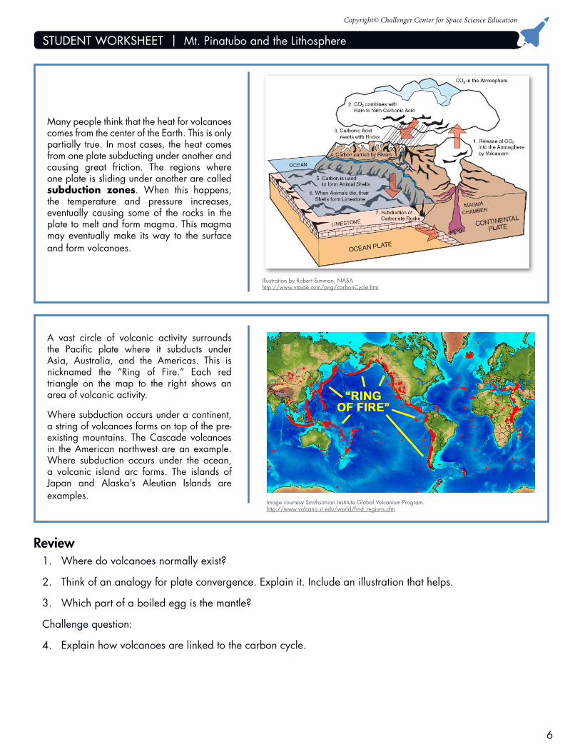
Many people think that the heat for volcanoes comes from the center of the Earth. This is only partially true. In most cases, the heat comes from one plate subducting under another and causing great friction. The regions where one plate is sliding under another are called subduction zones. When this happens, the temperature and pressure increases, eventually causing some of the rocks in the plate to melt and form magma. This magma may eventually make its way to the surface and form volcanoes.
Illustration by Robert Simmon, NASAhttp://www.vtaide.com/png/carbonCycle.htm
Image courtesy Smithsonian Institute Global Volcanism Program.http://www.volcano.si.edu/world/find_regions.cfm
Review1. Where do volcanoes normally exist?
2. Think of an analogy for plate convergence. Explain it. Include an illustration that helps.
3. Which part of a boiled egg is the mantle?
Challenge question:
4. Explain how volcanoes are linked to the carbon cycle.
A vast circle of volcanic activity surrounds the Pacific plate where it subducts under Asia, Australia, and the Americas. This is nicknamed the “Ring of Fire.” Each red triangle on the map to the right shows an area of volcanic activity.
Where subduction occurs under a continent, a string of volcanoes forms on top of the pre-existing mountains. The Cascade volcanoes in the American northwest are an example. Where subduction occurs under the ocean, a volcanic island arc forms. The islands of Japan and Alaska’s Aleutian Islands are examples.
Copyright© Challenger Center for Space Science Education
STUDENT WORKSHEET | Mt. Pinatubo and the Lithosphere
7
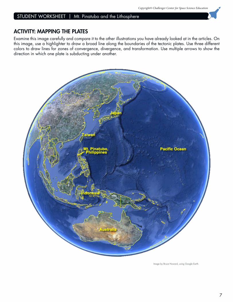
ACTIVITY: MAPPING THE PLATESExamine this image carefully and compare it to the other illustrations you have already looked at in the articles. On this image, use a highlighter to draw a broad line along the boundaries of the tectonic plates. Use three different colors to draw lines for zones of convergence, divergence, and transformation. Use multiple arrows to show the direction in which one plate is subducting under another.
Image by Bruce Howard, using Google Earth.
Copyright© Challenger Center for Space Science Education
STUDENT WORKSHEET | Mt. Pinatubo and the Lithosphere
8
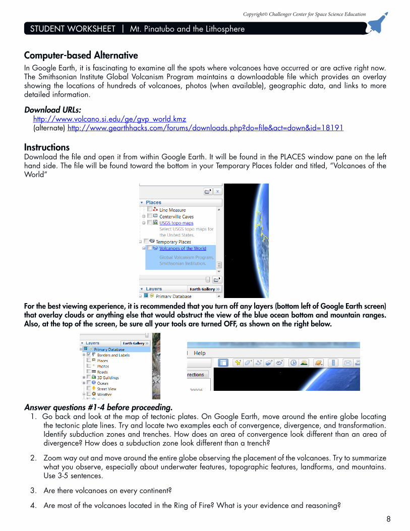
Computer-based AlternativeIn Google Earth, it is fascinating to examine all the spots where volcanoes have occurred or are active right now. The Smithsonian Institute Global Volcanism Program maintains a downloadable file which provides an overlay showing the locations of hundreds of volcanoes, photos (when available), geographic data, and links to more detailed information.
Download URLs:http://www.volcano.si.edu/ge/gvp_world.kmz (alternate) http://www.gearthhacks.com/forums/downloads.php?do=file&act=down&id=18191
InstructionsDownload the file and open it from within Google Earth. It will be found in the PLACES window pane on the left hand side. The file will be found toward the bottom in your Temporary Places folder and titled, “Volcanoes of the World”
For the best viewing experience, it is recommended that you turn off any layers (bottom left of Google Earth screen) that overlay clouds or anything else that would obstruct the view of the blue ocean bottom and mountain ranges. Also, at the top of the screen, be sure all your tools are turned OFF, as shown on the right below.
Answer questions #1-4 before proceeding.1. Go back and look at the map of tectonic plates. On Google Earth, move around the entire globe locating
the tectonic plate lines. Try and locate two examples each of convergence, divergence, and transformation. Identify subduction zones and trenches. How does an area of convergence look different than an area of divergence? How does a subduction zone look different than a trench?
2. Zoom way out and move around the entire globe observing the placement of the volcanoes. Try to summarize what you observe, especially about underwater features, topographic features, landforms, and mountains. Use 3-5 sentences.
3. Are there volcanoes on every continent?
4. Are most of the volcanoes located in the Ring of Fire? What is your evidence and reasoning?
Copyright© Challenger Center for Space Science Education
STUDENT WORKSHEET | Mt. Pinatubo and the Lithosphere
9
Synthesizing ObservationsUse what you have learned here to write one paragraph to a person less-knowledgeable than yourself. Explain what scientific processes caused these five volcanoes to become so dangerous.
NOTE: You may now want to go back and fill in more of your Event-to-Sphere and Sphere-to-Sphere worksheet.
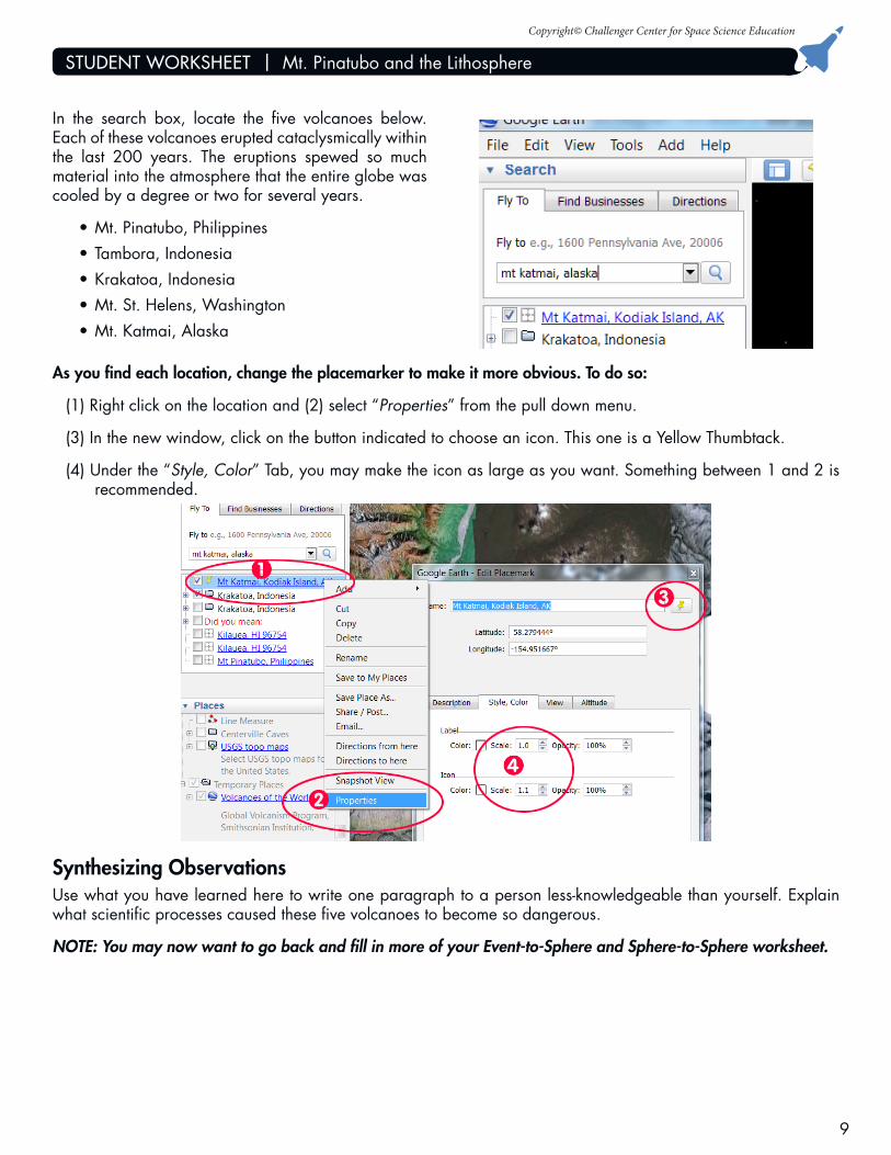
In the search box, locate the five volcanoes below. Each of these volcanoes erupted cataclysmically within the last 200 years. The eruptions spewed so much material into the atmosphere that the entire globe was cooled by a degree or two for several years.
•Mt.Pinatubo,Philippines•Tambora,Indonesia•Krakatoa,Indonesia•Mt.St.Helens,Washington•Mt.Katmai,Alaska
As you find each location, change the placemarker to make it more obvious. To do so:
(1) Right click on the location and (2) select “Properties” from the pull down menu.
(3) In the new window, click on the button indicated to choose an icon. This one is a Yellow Thumbtack.
(4) Under the “Style, Color” Tab, you may make the icon as large as you want. Something between 1 and 2 is recommended.

Copyright© Challenger Center for Space Science Education
STUDENT WORKSHEET | Mt. Pinatubo and the Lithosphere
10
Extension: Qualitative Data AnalysisIn May and throughout June and July, scientists collected seismic data on Mt. Pinatubo. Some types of data were quantitative, and other types were qualitative. Quantitative data is the type you most often see in bar graphs, or line charts. It is numerical. It typically comes from some sort of measurement. In the case of volcanoes, quantitative data might be the number of earthquakes as measured by a seismometer, or ash plume height as measured by trained observers. Qualitative data is typically visual in nature or descriptive of a situation. It is usually describing something of importance which cannot be easily measured with instruments. It is subjective, or based on the observer’s perspective. Qualitative data for a volcano might be the size of an increasing dome of rock; a description of the size, type, and color of a cloud produced; or the sound or smell nearby.
For this activity, you will learn to make use of qualitative data to draw conclusions. Other than earthquakes or ash cloud heights, you want to answer the question:
“How did the quality of everything around the volcano change as a result of the eruption?”
You need to study these four topics (you may want to form a group of four or pairs and divide them up):
•Everythingabove the ground before the eruption
•Everythingbelow the ground before the eruption
•Everythingabove the ground after the eruption
•Everythingbelow the ground after the eruption
Visit these three websites and fill in the following chart ONCE for EACH of the four topics above. You do not have to fill in every row. You are filling in anything of a qualitative nature that was observed from above the ground and below the ground. Your observations should lead to a logical and well-informed answer to the scientific question above.
•http://vulcan.wr.usgs.gov/Volcanoes/Philippines/Pinatubo/Publications/Wolfe/wolfe_report.html
•http://pubs.usgs.gov/fs/1997/fs113-97/
•http://www.volcano.si.edu/world/volcano.cfm?vnum=0703-083&volpage=var#bgvn_1605
Name:___________________________________________ Date:______________________
Some of the observations have been filled in for you as an example.
Copyright© Challenger Center for Space Science Education
STUDENT WORKSHEET | Mt. Pinatubo and the Lithosphere
11
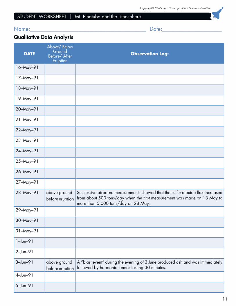
DATE
Above/ Below Ground
Before/ After Eruption
Observation Log:
16–May–91
17–May–91
18–May–91
19–May–91
20–May–91
21–May–91
22–May–91
23–May–91
24–May–91
25–May–91
26–May–91
27–May–91
28–May–91 above groundbefore eruption
Successive airborne measurements showed that the sulfur-dioxide flux increased from about 500 tons/day when the first measurement was made on 13 May to more than 5,000 tons/day on 28 May.
29–May–91
30–May–91
31–May–91
1–Jun–91
2–Jun–91
3–Jun–91 above groundbefore eruption
A “blast event” during the evening of 3 June produced ash and was immediately followed by harmonic tremor lasting 30 minutes.
4–Jun–91
5–Jun–91
Qualitative Data AnalysisName:___________________________________________ Date:______________________
Copyright© Challenger Center for Space Science Education
STUDENT WORKSHEET | Mt. Pinatubo and the Lithosphere
12
6–Jun–91
7–Jun–91
8–Jun–91
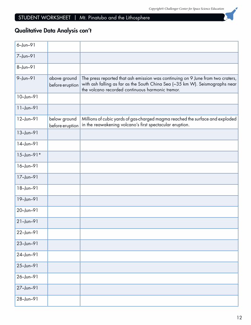
9–Jun–91 above groundbefore eruption
The press reported that ash emission was continuing on 9 June from two craters, with ash falling as far as the South China Sea (~35 km W). Seismographs near the volcano recorded continuous harmonic tremor.
10–Jun–91
11–Jun–91
12–Jun–91 below groundbefore eruption
Millions of cubic yards of gas-charged magma reached the surface and exploded in the reawakening volcano’s first spectacular eruption.
13–Jun–91
14–Jun–91
15–Jun–91*
16–Jun–91
17–Jun–91
18–Jun–91
19–Jun–91
20–Jun–91
21–Jun–91
22–Jun–91
23–Jun–91
24–Jun–91
25–Jun–91
26–Jun–91
27–Jun–91
28–Jun–91
Qualitative Data Analysis con’t

Copyright© Challenger Center for Space Science Education
STUDENT WORKSHEET | Mt. Pinatubo and the Lithosphere
13
29–Jun–91
30–Jun–91
1–Jul–91
2–Jul–91
3–Jul–91
4–Jul–91
5–Jul–91
6–Jul–91
7–Jul–91
8–Jul–91
9–Jul–91
10–Jul–91
11–Jul–91
12–Jul–91
13–Jul–91
14–Jul–91
15–Jul–91
Qualitative Data Analysis con’t