Embed Size (px)
Citation preview

To reduce traffic through townthe local authority for theGerman town of Traunsteindecided to build a bypass roadstarting in spring 2009 andincluding a new tunnel underthe Munich – Salzburg railwayline. The track owner, DeutscheBahn AG (DB), stipulated con-tinuous monitoring of thestretch of rail affected by thetunneling operations. Lead consultant Bernd Gebauer GmbHdecided to install a track posi-tion monitoring system andengaged consulting engineersing Traunreut GmbH for thetask. The system of freely com-binable measurement sensorsfrom Leica Geosystems in con-junction with the Leica GeoMoSor GeoMoS Web monitoringsoftware proved to be perfectlysuited to this task.
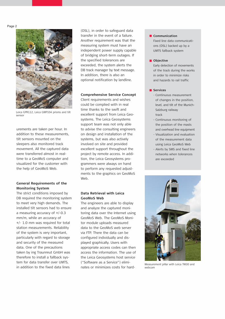
The installed measuring system
not only uses Leica TCA1800 Total
Stations but is also testing the
new Leica TM30, a total station
specially developed for monitoring.
These motorized sensors ensure
that measurements to 100 prisms
attached directly to the structure
are taken and recorded continu-
ously, around the clock. Also in-
stalled are meteorological sensors,
a webcam, and 38 tilt sensors.
The total stations were set up on
two pillars, each about three
meters tall, in a settlement-free
area and protected from the
weather, vandalism, and theft by
a specially manufactured housing.
The highly accurate total stations
automatically measure the 100
prisms in specified measurement
cycles from two positions per
cycle. Two complete sets of meas-
Companying Traunreut GmbH, Germanywww.ing-ingenieure.de
ChallengeTrack monitoring of the Munich-Salzburg railway line during the con-struction of the Ettendorf Tunnel(crossing under the tracks)
CustomerFederal Republic of Germany (StateBuilding Authority, Traunstein)
Project periodJune 2009 to June 2010
Location
Project summaryHardwareLeica TCA1800Leica TM30Leica GPR112 monitoring prisms Leica GMP104 mini prisms Tilt sensorsMeteorological sensorsWebcam (panTerra.tv)SoftwareLeica GeoMoS MonitorLeica GeoMoS AnalyzerLeica GeoMoS WebWeb service panTerra.tvSMS delivery function aspsms.com
Leica Geosystems TruStoryTrack Monitoring Traunstein, Germany
Munich-Salzburg railway line above the tunnel site
urements are taken per hour. In
addition to these measurements,
tilt sensors mounted on the
sleepers also monitored track
movement. All the captured data
were transferred almost in real-
time to a GeoMoS computer and
visualized for the customer with
the help of GeoMoS Web.
General Requirements of theMonitoring SystemThe strict conditions imposed by
DB required the monitoring system
to meet very high demands. The
installed tilt sensors had to ensure
a measuring accuracy of +/-0.3
mm/m, while an accuracy of
+/- 1.0 mm was required for total
station measurements. Reliability
of the system is very important,
particularly with regard to storage
and security of the measured
data. One of the precautions
taken by ing Traunreut GmbH was
therefore to install a fallback sys-
tem for data transfer over UMTS,
in addition to the fixed data lines
(DSL), in order to safeguard data
transfer in the event of a failure.
Another requirement was that the
measuring system must have an
independent power supply capable
of bridging short-term outages. If
the specified tolerances are
exceeded, the system alerts the
DB track manager by text message.
In addition, there is also an
optional notification by landline.
Comprehensive Service ConceptClient requirements and wishes
could be complied with in real
time thanks to the swift and
excellent support from Leica Geo-
systems. The Leica Geosystems
support team was not only able
to advise the consulting engineers
on design and installation of the
systems, but was also actively
involved on site and provided
excellent support throughout the
project by remote access. In addi-
tion, the Leica Geosystems pro-
grammers were always on hand
to perform any requested adjust-
ments to the graphics on GeoMoS
Web.
Data Retrieval with LeicaGeoMoS WebThe engineers are able to display
and analyze the captured moni-
toring data over the Internet using
GeoMoS Web. The GeoMoS Moni-
tor module uploads measured
data to the GeoMoS web server
via FTP. There the data can be
configured individually and dis-
played graphically. Users with
appropriate access codes can then
access the information. The use of
the Leica Geosystems host service
(“Software as a Service”) elimi-
nates or minimizes costs for hard-
Page 2
Communication
Fixed line data communicati-
ons (DSL) backed up by a
UMTS fallback system
Objective
Early detection of movements
of the track during the works
in order to minimize risks
and hazards to rail traffic
Services
- Continuous measurement
of changes in the position,
level, and tilt of the Munich-
Salzburg railway
track
- Continuous monitoring of
the position of the masts
and overhead line equipment
- Visualization and evaluation
of the measurement data
using Leica GeoMoS Web
- Alerts by SMS and fixed line
networks when tolerances
are exceeded
Leica GPR112, Leica GMP104 prisms and tiltsensor
Measurement pillar with Leica TM30 andwebcam

ware, software, and IT. New fea-
tures are always made immediate-
ly available to all users and do not
require any further installation on
the customer's computer, while
the encrypted web service looks
after the secure transfer of data
over the Internet. The customer
gains access to the graphics on
GeoMoS Web from a login screen.
Once logged in, he can analyze
the data, e.g. by changing the
time frame or extracting the results
from one of more points or sen-
sors. By installing a high-resolution
webcam ing Traunreut offers cus-
tomers the additional benefit of a
quick overview of the actual site
conditions through GeoMoS Web.
By installing a high-resolution web-
cam from panterra.tv (German mo-
dule partner of Leica Geosystems),
ing Traunreut GmbH was also able
to offer its customer the addition-
al option of obtaining a quick
overview of the actual conditions
on site through GeoMoS Web.
Changes in Track PositionWith GeoMoS Web, the client can
get information about current
changes in track position at any
time during the works. Some of
the larger movements were
observed in particular during tun-
nel shield driving in Phase 2. On
two occasions it was necessary to
carry out track rectification after a
depression with a vertical dis-
placement of up to 25 mm
appeared in a length of track.
Since the start of track monitor-
ing, the track has settled up to 5
cm. However, not just tracks are
affected: movements were also
observed in the overhead line
masts. A tilt of almost 7 mm/m
developed in a mast foundation,
which translated into a displace-
ment of the overhead line of 3 to
4 cm and meant that the position
of the overhead line on the south-
ern mast had to be corrected. All
settlements were detected at an
early stage by the monitoring sys-
tem. This allowed appropriate
early corrective measures to be
implemented before reaching a
stage where notification of the
track maintenance manager would
have been necessary - which
would have triggered an expensive
temporary closure of that com-
plete section. Instead corrective
work could be carried out
between trains or required only a
temporary closure of the track in
one direction.
Test Phase with Leica TM30Since the start of the project the
ing Traunreut engineers used two
Leica TCA1800 total stations for
monitoring. These traditional
monitoring instruments impressed
the engineers with their robust-
ness and reliability. To prepare for
future monitoring projects with
similar or higher requirements,
ing Traunreut GmbH decided to
test the new Leica TM30 moni-
toring sensor in this role. After
completion of the first monitoring
phase, one of the TCA1800s was
replaced by a Leica TM30. The
new model remained in operation
throughout the entire second
monitoring phase, during which
time it made a big impression,
measuring almost silently with its
new piezo drive capable of higher
rotation speeds, whilst achieving
improved accuracy over a longer
range. It also offers two very use-
Page 3
Graphics Leica GeoMoS Web (track distortion)

Page 4
ful functions in TargetView and
TargetCapture. Using TargetView,
the instrument can select the
correct prism from several others
in the immediate vicinity. The
TargetCapture function stores a
digital image of the field of view
for target-point documentation
purposes. This not only allows the
causes of obstructed visibility,
such as mist, to be identified, it
can also be combined with a web-
cam. Compared with the TCA1800,
in the same time the Leica TM30
measured twice as many points
with a higher accuracy. Even
though the TCA1800 total station
fulfils the requirements of this
project for the time being, in the
future the Leica TM30 could take
over this role on monitoring proj-
ects. ConclusionThis project shows yet again how
important and worthwhile a moni-
toring system is for site supervi-
sion. The measurement and analy-
sis of track deformation, including
fast reactions to the changes,
would not have been possible
without such a system. Damage to
existing infrastructure, and possi-
bly to passengers and site staff,
could have had grave conse-
quences.
Leica Geosystems AGHeinrich-Wild-Strasse CH-9435 Heerbrugg Switzerland Phone +41 71 727 31 31
www.leica-geosystems.com
The graph shows the longitudinal profile with the measurement series V prisms.The measurements from P506 to P511 clearly show the formation of the sag in the track.
Installation of pipe canopy tunnel lining (monitoring phase II)